national functional classification - michigan.gov€¦ · state of michigan national functional...
TRANSCRIPT

STATE OF MICHIGAN
National Functional Classification Post-2010 Census Statewide Review
8/29/2014
Prepared by Michigan Department of Transportation, Bureau of Transportation Planning, Asset Management Section August 2014

NFC Post-2010 Census Statewide Review Prepared by MDOT, Asset Management Section, August 2014 Page 1
Table of Contents 1. Introduction .................................................................................................................... 3
• Emphasis Area 1 ...................................................................................................... 3
• Emphasis Area 2 ...................................................................................................... 3
• Summary .................................................................................................................. 4
2. Functional Classification Review Process ..................................................................... 5
• Beginning the Review ............................................................................................. 5
• Process Steps ........................................................................................................... 5
3. Supporting Information .................................................................................................. 8
• Definitions ............................................................................................................... 8
• Regulations .............................................................................................................. 9
• Act 51 of Public Act 1951 ..................................................................................... 10
• Non-Trunkline Other Principal Arterials ............................................................... 10
• FHWA Percentage Guidelines............................................................................... 11
• Application of Percentage Guidelines ................................................................... 11
• Rural City and Villages ......................................................................................... 12
• Responsible Local Official Notification ................................................................ 12
• Cooperation and Data ............................................................................................ 13
• Michigan's Transportation Asset Management Council ........................................ 13
• Mapping NFC, NHS and ACUB ........................................................................... 13
• HPMS Re-assessment ............................................................................................ 13
• Federal-Aid Design Standards ............................................................................... 13
• Future Routes ......................................................................................................... 14
• Traffic Count and Data Collection Requirements ................................................. 14
• Act 51 Coordination .............................................................................................. 15
• The Current FHWA Highway FC Guidance (2013) Link: .................................... 16
• MDOT NFC Web Site: .......................................................................................... 16

NFC Post-2010 Census Statewide Review Prepared by MDOT, Asset Management Section, August 2014 Page 2
• Other MDOT Web Sites Related to NFC: ............................................................. 16
• FHWA National Highway System (NHS) Web Site: ............................................ 17
• MDOT NFC Web Mapping Application: .............................................................. 17
• Post NFC Statewide Review Re-classification Process ........................................ 17
4. Attachments .................................................................................................................. 18
• 1. MAB/MPO and RPA Boundary Map ................................................................ 18
• 2. MI-Format Summary ......................................................................................... 18
• 3. MI-Format Detail ............................................................................................... 18
• 4. Resolution .......................................................................................................... 18
• 5. NFC Worksheet ................................................................................................. 18
• 6a and 6b Attachments - NFC Review Process Workflows .................................. 18
• 7. FHWA February 19, 2014 Memorandum ......................................................... 18

NFC Post-2010 Census Statewide Review Prepared by MDOT, Asset Management Section, August 2014 Page 3
1. Introduction The Highway Functional Classification is a federal grouping system for public roads. The Michigan Department of Transportation (MDOT) continues to refer to it as the National Functional Classification (NFC). After the 2010 Decennial United States Census and urban area adjustment, the Federal Highway Administration (FHWA) has the state coordinate a statewide review of the entire NFC system with the responsible public road agency officials. All NFC designations must have FHWA approval. There are NFC individual revisions and the NFC statewide review. Individual revisions are usually initiated by the local agency between statewide reviews and are for a specific route. The statewide review invites all appropriate agencies to participate and review all their NFC values. MDOT plans to continue processing individual NFC revisions after the statewide review. The FHWA descriptive criteria are the primary deciding factors in NFC classification. Data may be used, but it is secondary in NFC determination as metrics overlap functional classes and vary by geographical location. When assigning NFC, generally the higher the mobility, trip distance, speed limit and traffic volume, the higher the NFC function. Inadequate funding or a route in need of repair does not justify a higher NFC. Due to extensive revisions during the post-2000 Census NFC statewide review back in 2004-2006 and many individual revisions since, the state’s current NFC is thought to only need fine tuning. For the statewide review, two main emphasis areas have been determined; they are due to the mileage percentages in the new 2013 FHWA Highway Functional Classification guidance and a February 19, 2014 FHWA memorandum (see enclosure). Agencies should limit their selection to the best qualified routes.
• Emphasis Area 1 MDOT and Metropolitan Planning Organizations (MPO) are asked to review all existing urban Other Principal Arterials to determine if any act as Minor Arterial and propose those revisions. If a NFC revision is proposed from an Other Principal Arterial, then an appropriate revision to the National Highway System (NHS) should be considered. Support: The Feb 19, 2014, FHWA memo and FHWA guidance for “all states” shows urban Other Principal Arterial mileage between 4.0% and 5.0%. Michigan is above this range at 6.2%.
• Emphasis Area 2 Agencies are asked to review all rural Major Collectors to determine if any act as Minor Collector or Minor Arterial and propose those revisions. It is suggested to review Major Collectors that are non-paved or have low Annual Average Daily Traffic).

NFC Post-2010 Census Statewide Review Prepared by MDOT, Asset Management Section, August 2014 Page 4
Support: FHWA guidance for “all states” shows rural Major Collector mileage between 9.0% and 19.0%. Michigan is above this range at 19.8%.
• Summary The statewide review process can be summed up as group meeting, review, submitting proposal materials to MDOT, MDOT review, MDOT proposals to FHWA, FHWA decision and incorporation into MDOT official maps/databases. Below is the process timeline.
o Regional Planning Agencies (RPA)
coordinated MDOT group meetings September 2014 – April 2015 o Other Principal Arterial/NHS proposals Due April 30, 2015 o Remaining NFC Revision Proposals Due Sept 1, 2015 o FHWA approvals (estimated) May 2015 – November 2015 o Local notification and Michigan Geographic
Framework (MGF) mapping June 2015 – January 2016 A public NFC web mapping application is under development to aid in decision making, communication, and viewing of revision status.
This document in electronic form can be obtained from sub-links at the MDOT NFC public website; http://www.michigan.gov/mdot/0,1607,7-151-9622_11033_11155---,00.html

NFC Post-2010 Census Statewide Review Prepared by MDOT, Asset Management Section, August 2014 Page 5
2. Functional Classification Review Process This section explains how to do the agency review and prepare the materials required to propose NFC revisions. A graphical flowchart of this process is included for non-MPO and MPO agencies respectively in attachments 6a and 6b (see enclosures).
• Beginning the Review You may be new to the concept of NFC or perhaps haven't looked at NFC in a while. A suggested first step for this review is to study the enclosed NFC map. If you are familiar with the roads in your area and know the various routes commuters use to go to and from work, school and other travel, review the maps and use the legend to see how they are classified. Michigan has over 122,000 miles of public roadways and the great majority of these already have the appropriate NFC. As you study the map you can gain an idea of what arterials, collectors, and NFC local roads "look and behave like."
With your knowledge of the local area, the second step is to be aware of changes that have occurred since the last NFC statewide review (2004-2006) and how those changes have affected traffic. These changes, if significant, may have affected the functional classification of the route. For example, in an undeveloped area, perhaps a shopping mall, industrial park, major new residential developments or a new school has been built. Or, the opposite may be true, expected development did not occur or the area experienced a reduction in population or closing of traffic generators. For the routes serving the areas of these major changes, a NFC re-classification may be appropriate.
• Process Steps These steps assume use of the supplied paper maps. If you wish to use GIS, contact the MDOT coordinator to obtain an acceptable GIS file and instructions.
1. Appropriate officials should review all the sent materials plus the new 2013 FHWA Highway Functional Classification guidance through the provided link (see page 16). MPO’s will work within their structure to contact and invite all appropriate agencies.
2. Contact your RPA to attend a group meeting at an MDOT region or Transportation Service Center (TSC) office with the MDOT NFC coordinator.
3. At the group meeting, review the NFC of your system paying particular attention to the relevant emphasis area(s) of the statewide review. Determine major changes that occurred in the last 10 years that can affect the function of the roads and mark where and what they are on the map. Look at all roads in your area, not just your jurisdiction and determine how they function together. Select routes that are improperly classified to discuss with the MDOT NFC coordinator.

NFC Post-2010 Census Statewide Review Prepared by MDOT, Asset Management Section, August 2014 Page 6
4. At the group meeting or after, clearly highlight the proposed NFC route revision(s) on the supplied map. Mark each NFC proposal with a “Map ID” of your choosing to correspond with the “Map ID” in the NFC worksheet (attachment 5). Date the paper map(s). For MPO’s, it is recommended to create a separate proposal package for any proposed Other Principal Arterials and NHS revisions. Send one copy of everything to MDOT; keep a copy for your agency.
5. Fill out a NFC worksheet (attachment 5) for each NFC route revision request that is referenced by the “Map ID” you created and identified on the map. 6. For each proposed functional classification revision upgrade, if the State of Michigan’s Non-Trunkline Federal-Aid (NTFA) count http://www.mcgi.state.mi.us/ntfa/ is unknown or from a traffic count collection year prior to 2013, supply electronic MI-Format traffic counts by email to [email protected] (see attachments 6a and 6b). 7. The mailed “package” of proposal materials you supply to MDOT will include a letter from your responsible local official. The letter will include a list of the proposed NFC changes adopted through your local/MPO process. The list will reference the dated map(s) and dated worksheet(s). Proposed routes should be listed with full street names, to and from descriptions, current NFC, proposed NFC, and length (miles). Return the letter, worksheet(s), map(s), and a signed resolution (attachment 4). There is a check box option if you do not have any changes; this is to show that you reviewed the system.
If you are a MPO and have proposed revisions to OPAs, it is your option to place the NFC OPA proposals to another “proposal package.” Whenever an OPA is reclassified, a corresponding revision to the NHS should be considered. FHWA requires NHS proposals to be a separate request from NFC so for your OPA NFC upgrade or downgrade proposal, please include a corresponding NHS proposal. For any upgrades to OPA/NHS, the NHS proposal should include references to all NHS requirements listed in Title 23 CFR §470.107-109, §470.113 and Appendix D to Subpart A of Part §470 (discussed in greater detail on page 10). Proposed downgrades and removal from OPA/NHS requests should answer Appendix D numbers 3, 6-8 and why it no longer functions as an OPA.
All OPA/NHS proposals are due April 30, 2015, and will be reviewed together by MDOT and FHWA. See attachment 7.
The due date for all other NFC proposals is September 1, 2015.

NFC Post-2010 Census Statewide Review Prepared by MDOT, Asset Management Section, August 2014 Page 7
8. Send all printed materials to MDOT by U.S. mail to:
Michael Toth, Transportation Planner Michigan Department of Transportation Asset Management Division 425 West Ottawa Street P.O. Box 30050 Lansing, Michigan 48909 Mail Code: B340 Email electronic MI-Format and GIS files to: [email protected] 9. MDOT will review the requests and notify the agency if MDOT does not concur or if relevant information is missing or unclear. All requests that MDOT concurs with will be sent to FHWA as proposed NFC revisions.
10. MDOT will notify the agency of FHWA’s decision and enter approved revisions into the MGF, MDOT databases, and the future NFC mapping Web application.

NFC Post-2010 Census Statewide Review Prepared by MDOT, Asset Management Section, August 2014 Page 8
3. Supporting Information This section goes into the background, practices and details of the statewide review.
• Definitions Here is Title 23 USC, FHWA and MDOT definitions related to the Highway Functional Classification statewide review.
National Functional Classification (NFC) – NFC is a MDOT term for the Highway Functional Classification values. FHWA developed the highway functional classification method for all public roads. The higher functions emphasize mobility, the lower functions have more property access. The values from the highest mobility function down to the lowest include: Interstate, Other Freeways, Other Principal Arterials, Minor Arterials, Major Collectors, Minor Collectors, and Local. Adjusted Census Urban Boundary (ACUB) – At MDOT, it is the resulting area from adjusting the U.S. Census decennial urban areas over 5,000 populations outward in a cooperative process by transportation agencies following federal guidelines. The roads, cities and villages within or on the boundary are urban, the roads, cities and villages outside the ACUB are rural. Federal-aid Highways – Defined in Title 23 CFR §470.101(5) defines the term “federal-aid highway” as public roads “other than a highway classified as a local road or rural minor collector.” Federal-aid Highway Systems - Defined in Title 23 CFR §470.103 to mean” the NHS and the Dwight D. Eisenhower National System of Interstate and Defense Highways (the “Interstate System”).” Federal-aid Eligible – At MDOT, it is a term for a road that is fully eligible or has limited eligibility for federal Surface Transportation Program (STP) road funds, this currently includes rural minor collectors. This eligibility is determined by a combination of the roads NFC, urban/rural designation, and current federal legislation. Federal-aid or Federal-aid Systems – These terms are not legally defined. At MDOT, they are used most commonly to refer to federal-aid eligible routes. National Highway System (NHS) – FHWA states the NHS consists of roadways important to the nation’s economy, defense, and mobility. Below is a list of NFC values with a general description. At the highest level function is the Interstate, where mobility is the prime function; at the other end of the hierarchy is the Local functional classification where property access is the main function. The intermediate values are a blend of mobility vs. access. Some other criteria that NFC classification takes into account are relative regional importance, geography, speed limits, NFC mileage percentages, traffic, access management, connectivity, spacing, lanes, design, and traffic generators.
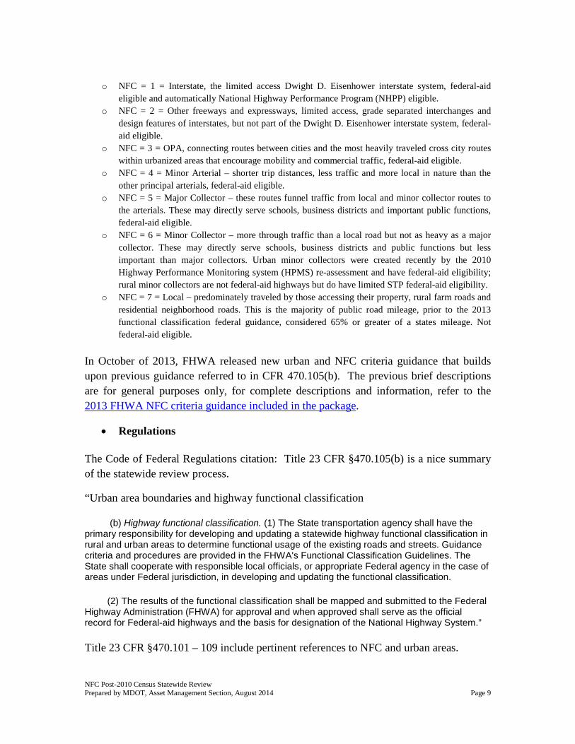
NFC Post-2010 Census Statewide Review Prepared by MDOT, Asset Management Section, August 2014 Page 9
o NFC = 1 = Interstate, the limited access Dwight D. Eisenhower interstate system, federal-aid
eligible and automatically National Highway Performance Program (NHPP) eligible. o NFC = 2 = Other freeways and expressways, limited access, grade separated interchanges and
design features of interstates, but not part of the Dwight D. Eisenhower interstate system, federal-aid eligible.
o NFC = 3 = OPA, connecting routes between cities and the most heavily traveled cross city routes within urbanized areas that encourage mobility and commercial traffic, federal-aid eligible.
o NFC = 4 = Minor Arterial – shorter trip distances, less traffic and more local in nature than the other principal arterials, federal-aid eligible.
o NFC = 5 = Major Collector – these routes funnel traffic from local and minor collector routes to the arterials. These may directly serve schools, business districts and important public functions, federal-aid eligible.
o NFC = 6 = Minor Collector – more through traffic than a local road but not as heavy as a major collector. These may directly serve schools, business districts and public functions but less important than major collectors. Urban minor collectors were created recently by the 2010 Highway Performance Monitoring system (HPMS) re-assessment and have federal-aid eligibility; rural minor collectors are not federal-aid highways but do have limited STP federal-aid eligibility.
o NFC = 7 = Local – predominately traveled by those accessing their property, rural farm roads and residential neighborhood roads. This is the majority of public road mileage, prior to the 2013 functional classification federal guidance, considered 65% or greater of a states mileage. Not federal-aid eligible.
In October of 2013, FHWA released new urban and NFC criteria guidance that builds upon previous guidance referred to in CFR 470.105(b). The previous brief descriptions are for general purposes only, for complete descriptions and information, refer to the 2013 FHWA NFC criteria guidance included in the package.
• Regulations The Code of Federal Regulations citation: Title 23 CFR §470.105(b) is a nice summary of the statewide review process.
“Urban area boundaries and highway functional classification
(b) Highway functional classification. (1) The State transportation agency shall have the primary responsibility for developing and updating a statewide highway functional classification in rural and urban areas to determine functional usage of the existing roads and streets. Guidance criteria and procedures are provided in the FHWA's Functional Classification Guidelines. The State shall cooperate with responsible local officials, or appropriate Federal agency in the case of areas under Federal jurisdiction, in developing and updating the functional classification.
(2) The results of the functional classification shall be mapped and submitted to the Federal Highway Administration (FHWA) for approval and when approved shall serve as the official record for Federal-aid highways and the basis for designation of the National Highway System.”
Title 23 CFR §470.101 – 109 include pertinent references to NFC and urban areas.

NFC Post-2010 Census Statewide Review Prepared by MDOT, Asset Management Section, August 2014 Page 10
Title 23 CFR §470.105 – 115 and Appendix D to Subpart A of Part §470 include pertinent references to the NHS.
Federal-aid highway routes have full federal-aid eligibility for STP funds. Rural minor collectors were extended limited federal-aid eligibility under MAP-21.
• Act 51 of Public Act 1951 The Michigan Transportation Fund, commonly known as Act 51 is a Michigan law that defines all public roads and the Michigan public transportation agencies that have jurisdiction over them. Only Act 51 public roads are assigned a NFC, non-certified public roads are not.
• Non-Trunkline Other Principal Arterials MDOT will continue its past practice that non-trunkline OPA can only occur in urbanized areas (population over 50,000). In general, OPA’s should favor mobility over access, allow commercial truck traffic, be rated all-season and be paved.
A memorandum from FHWA on February 19, 2014, was sent to the states (attachment 7). The memo allows the state to review all OPA in regards to the NHS. MDOT will review all OPA’s in cooperation with local officials at the NFC statewide review group meetings. Once all OPA/NHS proposals are in by April 30, 2015, MDOT will review the proposals with FHWA. All OPA highways on the NHS must comply with applicable federal regulations. These requirements include meeting design standards during reconstruction, contract administration, State-FHWA oversight procedures, HPMS reporting, National Bridge Inventory reporting, national performance measures data collection, and outdoor advertisement/junkyard control.

NFC Post-2010 Census Statewide Review Prepared by MDOT, Asset Management Section, August 2014 Page 11
• FHWA Percentage Guidelines MDOT will refer to the “Mileage Extent for All States” guidance percentages. Table 1.1 below, is extracted from tables 3-5 and 3-6 in the FHWA 2013 NFC guidance.
Table 1.1 All States\NFC (1)
Interstate (2) Other Freeway
(3) Other Principal Arterial
(4) Minor Arterial
(5) Major Collector
(6) Minor Collector
(7) Local
rural mileage max 2 % 2 % 6 % 7 % 19 % 15 % 75 % rural mileage min 1 % 0 % 2 % 3 % 9 % 4 % 64 % urban mileage max 3 % 2 % 5 % 14 % 15 % 15 % 75 % urban mileage min 1 % 0 % 4 % 7 % 7 % 7 % 63 %
Below, table 1.2 shows Michigan’s current NFC percentages. This is calculated using the Oct 31, 2013, approved ACUBs incorporated into the MGF.
Table 1.2 Mileage\NFC (1)
Interstate (2) Other Freeway
(3) Other Principal Arterial
(4) Minor Arterial
(5) Major Collector
(6) Minor Collector
(7) Local
Rural Mileage 0.7% 0.4% 2.6% 5.9% 19.8% 5.2% 65.5% Urban Mileage 1.8% 0.4% 6.2% 13.1% 10.3% 0.1% 67.6%
• Application of Percentage Guidelines Revising routes to be within mileage percentage guidelines was a past practice of the NFC statewide review. With the release of the new 2013 FHWA functional classification guidance, achieving statewide percentages within the 2013 guidance ranges is not a requirement. However, extending past the maximum of the guidance range is not encouraged; agencies should limit the selection to the best qualified routes. MDOT will calculate NFC mileage by rural county and ACUB areas within the state. If individual county and urban area percentages are above the FHWA guidance regardless of state percentages, MDOT may use this information to limit additions. This is to help create a more equitable and consistent distribution of federal-aid eligible routes within the state.

NFC Post-2010 Census Statewide Review Prepared by MDOT, Asset Management Section, August 2014 Page 12
• Rural City and Villages A past practice has been that Act 51 city and village agencies that are not within an ACUB follow rural NFC spacing guidelines and must have the county road agency concur. There are hundreds of Michigan cities and villages that: (1) have a census population less than 5,000; and, (2) are located outside any ACUB. FHWA calls these "rural cities" and as the name implies the spacing of collectors and higher in these areas follow rural guidelines. In general, the system of collectors and higher need to serve a "rural city or village," that is, provide access in and out. The ability to add additional collectors and higher within a "rural city or village" is subject to the following:
o The addition will not cause statewide or local percentage guidelines for rural collectors to be exceeded.
o The addition has the support of the county road agency. o The addition serves an important community function or strong commercial
purpose. o The proposed route is generally less than a mile in total length. o Generally, no more than one such "additional" collector or higher will be included
in the NFC system for any one "rural city or village.”
• Responsible Local Official Notification MDOT maintains the Act 51 Distribution and Reporting System (ADARS) database. This database contains the public road Act 51 local officials recognized to do business with MDOT. If applicable, it is the duty of the local ADARS official to notify their elected official(s) of the process. For the statewide review, MDOT directly contacts the Act 51 agencies outside of the MPO’s Metropolitan Area Boundary (MAB) minus the rural city and villages. In addition to Act 51 agencies, Sovereign Tribal Governments and public transit agencies are invited to participate in the process. Title 23 CFR §470.109 System Procedures—General “(c) …In urbanized areas, the local officials shall act through the metropolitan planning organizations designated for such areas under 23 U.S.C. 134.”
For any NFC proposed revision within a MPO, MDOT works through the MPO, not the ADARS officials. It is the MPO that will coordinate with the responsible local officials plus Sovereign Tribal Governments and public transit agencies within their process.

NFC Post-2010 Census Statewide Review Prepared by MDOT, Asset Management Section, August 2014 Page 13
• Cooperation and Data Supplying data required for federal or state reporting is considered an on-going annual cooperation process that local agencies make with MDOT and FHWA upon a route being established as federal-aid. The emphasis on cooperation between MDOT and MPO’s has been elevated to a higher level with MAP-21and NHPP measures.
• Michigan's Transportation Asset Management Council “Federal-aid” routes are linked to the Transportation Asset Management Council (TAMC) Program through Public Act 499 of 2002 (amended by P.A. 199 of 2007). Through TAMC, the Pavement Surface Evaluation and Rating (PASER) condition must be collected for all paved “federal-aid” routes.
• Mapping NFC, NHS and ACUB PDF maps of NFC and ACUBs are available on the MDOT public Website. Go to www.michigan.gov/mdot , on the left-side margin, click “Maps & Publications,” and then click “Maps,” then click “Federal-aid Highways.” Click on the desired link(s) in the lower right hand corner under “Maps.” It is possible for a collector or higher route to appear on your map, even though the road or street is permanently closed, or that the MGF line work is wrong. Please point these corrections out. Although the NFC statewide review is not an official process to update the MGF, the MDOT NFC coordinator will submit corrections to CSS to incorporate into the next version of MGF.
• HPMS Re-assessment The HPMS 2010 re-assessment replaced the NFC 1-19 classification values with NFC values 1-7. Urban and rural distinctions within NFC no longer exist and one can no longer look at the NFC value of a road and determine if the road is urban or rural. Roads that lie on the border or within an ACUB are considered urban.
NFC information - route extent and traffic - is reported by Michigan to FHWA via HPMS and is then used in allocation formulas decided by Congress for distributing federal-aid among the states. This adds importance to achieving an accurate representation of NFC.
• Federal-Aid Design Standards Any re-construction project using federal-aid dollars should follow the American Association of State Highway and Transportation Officials design requirements. MDOT has material posted on the Web below that contains information divided into two

NFC Post-2010 Census Statewide Review Prepared by MDOT, Asset Management Section, August 2014 Page 14
categories of design requirements, 3R and 4R:
http://mdotcf.state.mi.us/public/design/files/englishroadmanual/erdm03.pdf
The entire manual can be found at the following link:
http://mdotcf.state.mi.us/public/design/englishroadmanual/
Standards for 3R (resurfacing, restoration and rehabilitation) projects are tabulated in section 3.09.02A for NHS and 3.09.02B for non-NHS.
Standards for 4R (new construction and reconstruction) are tabulated in Appendix 3A. Please contact your agency engineer or your local MDOT TSC for additional information.
Additional design requirements for NHS are listed in Title 23 CFR §625.1- 4 – Design Standards for Highways – design and re-construction for NHS routes.
• Future Routes FHWA guidelines permit a ''future" collector or higher to be proposed. In this way, funding the construction of the "future" roadway can become a federal-aid eligible project.
"Future" collectors and higher should only be requested if the future route will function as a federal-aid highway, has local funding secured for the match, the project is in an approved Statewide Transportation Improvement Program (STIP), and it is expected to be under construction within the STIP timeframe of four years or less. Please inform MDOT during this process if routes displayed as future in the supplied maps have been built or are un-likely to be built.
Section 1.1.2 of the new highway functional classification guidance addresses future routes and is the basis for the future NFC re-classification.
Section 1.1.2 - “States should assign functional classifications according to how the roadway is functioning in the current year only. With regard to future routes, roads should be functionally classified with the existing system if they are included in an approved Statewide Transportation Improvement Program (STIP) and are expected to be under construction within the STIP timeframe of 4 years or less…"
• Traffic Count and Data Collection Requirements To facilitate the process of collecting and reporting traffic counts to meet federal requirements, the MI-Format has been created. The MI-Format is described in attachments 2 and 3. The MI-Format consists of both summary and detail files with an

NFC Post-2010 Census Statewide Review Prepared by MDOT, Asset Management Section, August 2014 Page 15
Average Daily Traffic value.
RoadSoft is publically funded transportation asset management software created for Michigan’s local road agencies to assist them in proper asset management. MDOT has worked with RoadSoft and the RoadSoft Users Group to implement the MI-Format file export function. In RoadSoft, once your data is entered, go to “File” – “Export” – “Export Traffic Count Data…”
The RoadSoft software is available free to all of Michigan’s public road agencies including support and instruction. The MI-Format files will be entered into the NTFA Traffic count program at MDOT.
NTFA is the official source of federally reported non-trunkline traffic data. You can tell what year the traffic count data was collected by checking the proposed route in the NTFA web mapping application http://www.mcgi.state.mi.us/ntfa/. Zoom into the proposed route and use the “Identify” tool to click on the route. The “count year” is displayed in the information box. If the NTFA traffic “count year” was taken prior to 2013 or there is no info, you must submit traffic counts from 2013 or later in MI-format for each proposed NFC upgrade to minor collector or higher.
Details on assigning traffic counts and uniform traffic segments can be explained by the MDOT NTFA coordinator. The contact information is on the public Website at:
http://www.michigan.gov/mdot/0,4616,7-151-9621_15757_60302---,00.html
• Act 51 Coordination In Michigan, the Michigan Transportation Fund (MTF) known as Act 51, has its own road classification system which is not the same as NFC. The Act 51 classification system is referred to as “legal system” by MDOT and is broken down into five categories.
o Trunkline o County Primary o County Local o City Major o City Local
The Act 51 classification or legal system divides the MTF funds up among Michigan’s 617 road jurisdictions using formulas. The legal system classifications of county primary and city major are both deemed routes that are most important to that jurisdiction and follow the “Annual Road Mileage Certification for Cities and Villages Act 51 Public Act of 1951 as Amended” or “Annual Road Mileage Certification for Counties Act 51 Public

NFC Post-2010 Census Statewide Review Prepared by MDOT, Asset Management Section, August 2014 Page 16
Act of 1951 as Amended” instructions. Primary and Major routes have similarities to federal-aid highway functional classifications, but they are not the same. NFC Local and Act 51 city or county local have similarities, but they are not the same despite both being called local. With slight differences in qualifications, it is unlikely that the two systems would have a one to one correspondence. Each route must be looked at independently and justified by the FHWA functional guidance and not by a blanket decision to make all Act 51 county primary or city major a federal-aid NFC or vice-versa. Generally, federal-aid highways and the primary or major classifications should be paved or have plans to pave them.
The Act 51 legal system is an attribute on the MGF. However, the MGF is not the legal source for Act 51 mileage or certification and Act 51 changes may occur at any time during the year. If you have any questions about Act 51 designations in your area, refer to the certified Act 51 map(s) from the jurisdictional agency.
• The Current FHWA Highway FC Guidance (2013) Link:
http://www.fhwa.dot.gov/planning/processes/statewide/related/highway_functional_classifications/index.cfm The 2013 FHWA guidance document explains how to distinguish between the different highway functional classifications or NFC.
• MDOT NFC Web Site: http://www.michigan.gov/mdot/0,1607,7-151-9622_11033_11155---,00.html
• Other MDOT Web Sites Related to NFC: PR & CS Finder – Under map search, use the NFC link http://www.mcgi.state.mi.us/prfinder/ NTFA traffic count program http://www.mcgi.state.mi.us/ntfa
ACUB http://www.mcgi.state.mi.us/acub/
TAMC Dashboard http://mcgiwebuat.mcgi.state.mi.us/mitrp_dashboards/Data/PaserDashboard.aspx

NFC Post-2010 Census Statewide Review Prepared by MDOT, Asset Management Section, August 2014 Page 17
Truck Operators Map and Trunkline all-season routes http://www.michigan.gov/mdot/0,1607,7-151-9622_11033_32060---,00.html
• FHWA National Highway System (NHS) Web Site: http://www.fhwa.dot.gov/planning/national_highway_system/
• MDOT NFC Web Mapping Application:
This site is under development and expected to be operational sometime after the statewide review starts.
http://www.mcgi.state.mi.us/nfc/
• Post NFC Statewide Review Re-classification Process Once the post-2010 statewide NFC review concludes, MDOT plans to accept proposed individual NFC re-classifications. Forms and processes are subject to change and they will be made available on the MDOT federal-aid highway Website upon completion of the NFC statewide review.

NFC Post-2010 Census Statewide Review Prepared by MDOT, Asset Management Section, August 2014 Page 18
4. Attachments
• 1. MAB/MPO and RPA Boundary Map
• 2. MI-Format Summary – csv file of traffic counter location. This file is required when requesting a NFC upgrade and the reported NTFA count was taken before 2013 or does not exist in the NTFA program.
• 3. MI-Format Detail – Detailed information for above format. It is a csv file of hourly or 15 minute traffic count data over 48 hours and ADT value. If your agency agrees to store this data – in any format– and agrees to have it available for three years for federal or state auditing purposes, it is optional to send.
• 4. Resolution – To be signed by the responsible official(s) even if the agency has
no proposed NFC changes. This verifies that the NFC of all routes has been reviewed and your agency was invited to participate in the process.
• 5. NFC Worksheet – This is a two page worksheet. One worksheet is required for each NFC proposal. An electronic version is available on the MDOT NFC website http://www.michigan.gov/mdot/0,1607,7-151-9622_11033_11155---,00.html under “More NFC Information”. Click the “MDOT NFC Work Sheet” link.
• 6a and 6b Attachments - NFC Review Process Workflows
• 7. FHWA February 19, 2014 Memorandum


Attachment 2
MI-Format Summary
Type Description numeric ADT date ADT Date/Time numeric AADT numeric AADT Year decimal Factor date Based on ADT numeric Station PR Number character Station PR Name decimal Station Milepoint character Duration numeric Percent Commercial character Jurisdiction character Framework Map Version numeric FIPS Code true/false Notice whether user accepts storage
responsibility Traffic Count Data MUST be electronic and in csv file format. The last 4 columns will be the same for all rows when exported from a local RoadSoft user. Framework map version is usually numeric, but can have a letter included like it did with 13a. Comma Separated Value (csv), fields can be any number of characters separated by a comma.

Attachment 3 MI-Format Detail
Record Length = Characters Blocking Factor = Records
Site ID = 15 characters Character 1-2 County Number (1st 2 characters of control section, col. 1-2 above) Character 3-6 Station Number (station number in col. 11-14 above) Character 7-10 Machine Number (machine number in col. 45-48 above) Character 11-11 Day of Week (Day of Week in col. 35 above) Character 12-12 Type of count (Type of Count in col. 39 above) Character 13-13 Construction Code (Construction code in col. 44 above) Character 14-15 Direction (Direction of Travel in col. 36-37 above) Lane code (col. 38), ending hour of the first count period (col. 40-43), Date (col. 33-34) is taken from machine. *Fields required for Non-Trunkline Federal-Aid (NTFA) traffic counts. Traffic Count Data MUST be electronic and in csv file format.
Columns Length Description 1-2* 2 CO (County) MDOT county code, differs from rest of state. 3-5 3 CS_ (Rest of control section) 6-10* 5 Milepoint (Mile Point, 99.999 implied) 11-14* 4 Stat (Station Number) 15-21* 7 PRNUM (Primary Route Number) 22-26* 5 P.R. Mile Point 99.999 implied 27-30* 4 Year 31-32* 2 MO (Month) 33-34* 2 DA (Day) 35* 1 DW (Day of Week Code: Sunday = 1, Saturday = 7) 36-37* 2 Dir (Direction of Travel: 01= N., 02 = N.E., 09 = N.S., 10 = E.W., etc.) 38* 1 LN (Lane Code: 0= All lanes in a direction, 1 = drive lane, 2 = 2nd lane, etc.) 39 1 Cnttyp (Type of Count: (STWD, Operation, A.Q., etc.) 40-43* 4 StartHR (Ending Time of the 1st count period) 44 1 Cnstrcode (Construction Code) 45-48 4 Machine (Machine number that did the counting) 49* 1 HR_15 (Code: 1 = Hourly Counts, 2 = 15 Minute Counts) 50-53* 4 HOA (First 15 minute recording, blank for hourly) 54-57* 4 HOB (Second 15 minutes, blank for hourly) 58-61* 4 HOC (Third 15 minutes, blank for hourly) 62-66* 5 H1 (Fourth 15 minute period or First hourly recording) 67-457* 4 Repeats columns 48-457 for a total of 96 15 minute periods or 24 hourly periods 458-459 2 MO0 (Start Month Block ID) 460-461 2 DA0 (Start Date Block ID) 462-464 3 HRS (Total Hours in Block) 465-467 3 Filler

Attachment 4
MICHIGAN DEPARTMENT OF TRANSPORTATION
STATEMENT OF AGREEMENT FOR
NATIONAL FUNCTIONAL CLASSIFICATION UPDATE AND REVISION
Section 470.105(b) (1) of Title 23 - Code of Federal Regulations state that “the State transportation agency [Michigan Department of Transportation] shall have the primary responsibility for developing and updating a statewide highway functional classification in rural and urban areas to determine functional usage of the existing roads and streets…The state shall cooperate with responsible local officials…in developing and updating the functional classification.” The undersigned hereby certify that these provisions have been complied with in developing and updating the highway functional classification for (insert names as needed) or certify no changes in functional classification are required at this time: ☐ Proposed NFC revisions have been requested. ☐ After reviewing the materials and the current NFC, no revisions are proposed. _______________________________ ______________________________
City or Village County OR
____________________________________
Metropolitan Planning Organization \
[copy and add more pages as needed]
Name Title/Agency Date
Name Title/Agency Date
Name Title/Agency Date
Name Title/Agency Date

Attachment 5 Worksheet: Worksheet Date: _______________ National Functional Classification (NFC) Part 1: Basic Data Worksheet: Request to Revise NFC Worksheet and NFC Revision Process
Agencies Michigan Department of Transportation (MDOT) Federal Highway Administration (FHWA)
> Completes Parts 1 and 2 of the worksheet > Provide meeting minutes or letterhead of approval from all involved agencies of request. > Provides additional information to MDOT upon request
> Reviews the worksheet, requests additional information if needed, provides statewide system analysis as appropriate > CONCURS with request: Forwards worksheet and supporting information to FHWA > DOES NOT CONCUR with request: Provides a written explanation to Responsible Official. > Notifies Responsible Official, and other affected parties, of FHWA action > Updates official NFC maps and databases with FHWA approved NFC revisions
> Reviews the worksheet and other supporting information > > Approves or denies the request to revise NFC
For more information, contact Michael Toth, Transportation Planner, MDOT, at 517-335-2932 or [email protected] or write to Mike Toth at MDOT, Asset Management Section, 425 West Ottawa St, Lansing MI 48909 Responsible Official: Metropolitan Planning Organization (MPO) or County Road Commission (CRC) including for rural Act 51 City/Village’s or the Act 51 agency not in prior two choices.
Responsible Official/Contact Person Mailing Address Telephone Number/Email
Act 51 Agency/Contact Person Mailing Address Telephone Number/Email
ROUTE NAME* From To Length
*One revision per worksheet. Route may be a series of connected road names forming one route. Please hit your “Enter” button after the “box” to add more. Existing NFC Proposed NFC Map ID Future (unbuilt) Road?
Yes No (it is an existing road) Please hit your “Enter” button after the “box” to add more lines. TRAFFIC VOLUME INFORMATION – Recent 48 hour classification counts per route with hourly breakdown.** Average Daily Traffic (ADT) Percent Commercial Other (e.g., count duration, direction(s) – N only, N/S etc.)
Year Location (or mark on map as needed) Source (e.g., agency, consultant, etc.)
**Traffic count summary and detail electronic files must be submitted in MI-Formats. SUPPORTING INFORMATION Maps Other

Attachment 5 Worksheet: Worksheet Date: _______________ National Functional Classification (NFC) Part 2: Justification Worksheet: Request to Revise NFC Add more Part 2 pages as needed. Provide a narrative description of how the road or route functions according to its proposed NFC. Include details specific and/or unique to this road or route. This is the justification for the proposed NFC. Example: “72nd Ave./Industrial Dr./6th St. Route: The proposed rural minor collector route serves the Village Industrial Park. This park has 19 businesses currently in operation, mostly in the areas of light industry and manufacturing. Township traffic from the northwest enters the Village along Industrial Drive at 72nd Avenue. This traffic continues along 6th Street to County Drive, in order to access the business district, medical facilities, and the public school system. Commercial traffic from the Industrial Park uses 72nd Avenue both for ingress and egress, given its proximity to the interchange of Village Road with US-31. Planned improvements to Industrial Drive and 72nd Avenue will increase the use of this route as it attracts more growth to the area. The rural minor collector designation is suggested for this route since this will form a continuation of the rural minor collector route along Woodrow Road (6th Street within the Village). This designation also serves to contrast the more local nature of the 72nd Ave./Industrial Dr./6th St. route with the county-wide rural major collector routes along Village Road and County Drive.” Statewide System Analysis - MDOT use only
Appropriate to type of area (rural, urban, etc.) and
proposed function Connectivity
Yes No (explain) Spacing Yes No (explain) Traffic Volumes Yes No (explain) Service Provided Yes No (explain) Statewide/Local Percentage Guidelines Within Exceed (explain) / Within Exceed (explain)
Future Route Funding Yes No (explain)
Act 51 Legal System State trunkline County Primary City Major Other (explain) FHWA Action Date of FHWA Action
Approved Not Approved Other (Explain)


