n pepillo - dominican republic · glide number: n/a!(north atlantic ocean caribbean sea sargasso...
TRANSCRIPT
GLIDE number: N/A
!(
NORTHATLANTIC
OCEAN
CaribbeanSea
SargassoSea
Pepillo Salcedo
AzuaBahoruco
Barahona
ElSeybo
Espaillat
LaVega
Pe rav ia
PuertoPlata
Samaná
SanJuan
SánchezRamírez
SantiagoSantiago
Rodríguez
MonseñorNouel Hato
Mayor
Centre
Nord-Est
PuertoRico
06 07
09 10
1112
15 ^
CubaHaiti Dominican
Republic
NORTHATLANTIC
OCEAN
CaribbeanSea
SantoDomingo
Cartographic Information
Grid: WGS 1984 UTM Zone 19N map coordinate system
Full color ISO A1, medium resolution (200 dpi)
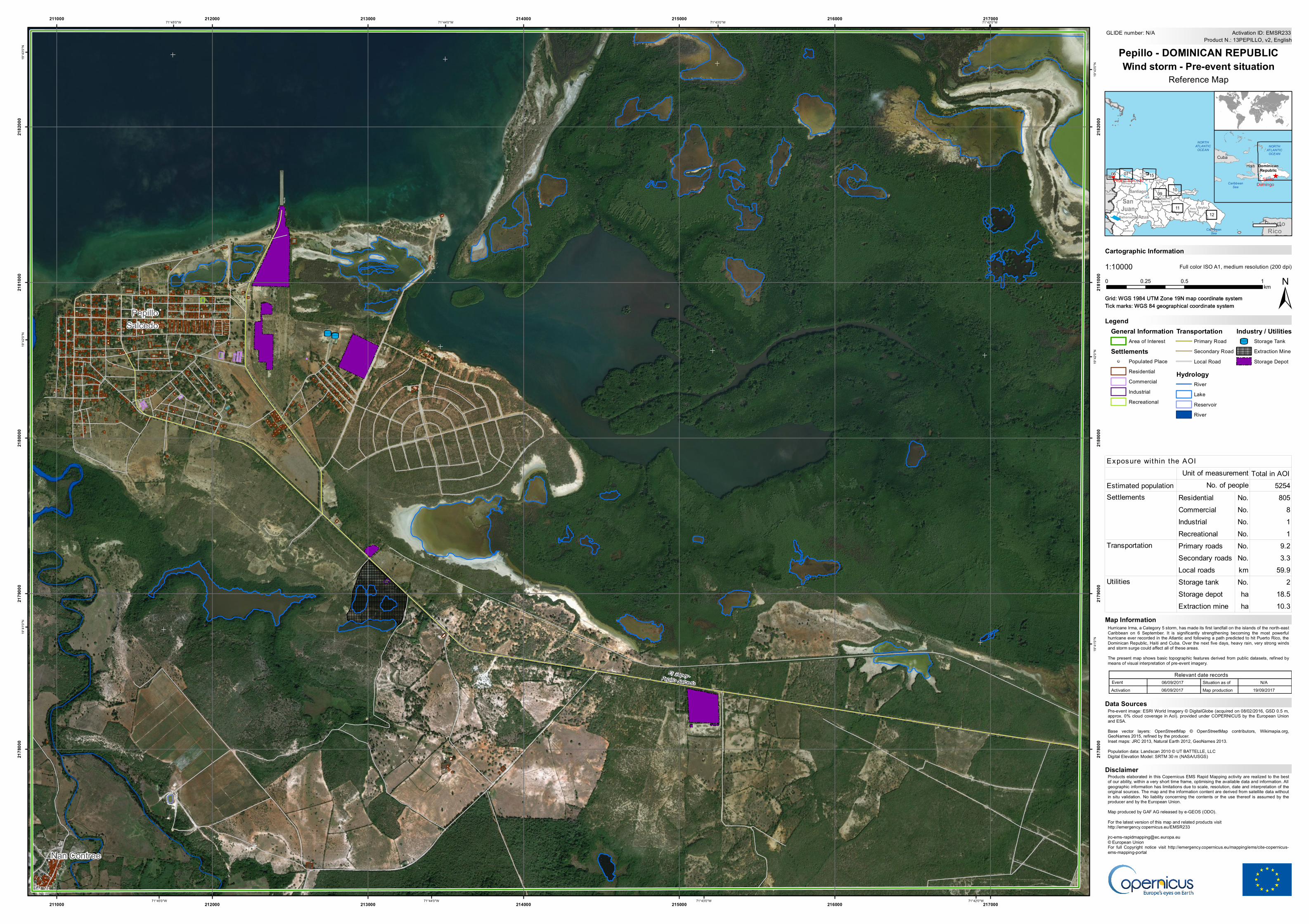
Hurricane Irma, a Category 5 storm, has made its first landfall on the islands of the north-eastCaribbean on 6 September. It is significantly strengthening becoming the most powerfulhurricane ever recorded in the Atlantic and following a path predicted to hit Puerto Rico, theDominican Republic, Haiti and Cuba. Over the next five days, heavy rain, very strong windsand storm surge could affect all of these areas.The present map shows basic topographic features derived from public datasets, refined bymeans of visual interpretation of pre-event imagery.
Products elaborated in this Copernicus EMS Rapid Mapping activity are realized to the bestof our ability, within a very short time frame, optimising the available data and information. Allgeographic information has limitations due to scale, resolution, date and interpretation of theoriginal sources. The map and the information content are derived from satellite data withoutin situ validation. No liability concerning the contents or the use thereof is assumed by theproducer and by the European Union.Map produced by GAF AG released by e-GEOS (ODO).For the latest version of this map and related products visithttp://emergency.copernicus.eu/[email protected]© European UnionFor full Copyright notice visit http://emergency.copernicus.eu/mapping/ems/cite-copernicus-ems-mapping-portal
LegendTick marks: WGS 84 geographical coordinate system
Product N.: 13PEPILLO, v2, EnglishActivation ID: EMSR233
Pre-event image: ESRI World Imagery © DigitalGlobe (acquired on 08/02/2016, GSD 0.5 m,approx. 0% cloud coverage in AoI). provided under COPERNICUS by the European Unionand ESA.Base vector layers: OpenStreetMap © OpenStreetMap contributors, Wikimapia.org,GeoNames 2015, refined by the producer.Inset maps: JRC 2013, Natural Earth 2012, GeoNames 2013.Population data: Landscan 2010 © UT BATTELLE, LLCDigital Elevation Model: SRTM 30 m (NASA/USGS)
Pepillo - DOMINICAN REPUBLICWind storm - Pre-event situation
Reference Map
Relevant date recordsEvent Situation as of06/09/2017 N/AActivation Map production06/09/2017 19/09/2017
Disclaimer
Data Sources
75km
Map Information
UTUT
!
!
El Copey-Pepillo Salcedo
Nan Contree
PepilloSalcedo
Source: Esri, DigitalGlobe, GeoEye, Earthstar Geographics, CNES/Airbus DS, USDA, USGS, AeroGRID, IGN, and the GIS User Community71°42'0"W
71°42'0"W
71°43'0"W
71°43'0"W
71°44'0"W
71°44'0"W
71°45'0"W
71°45'0"W19
°43'0
"N
19°4
3'0"N
19°4
2'0"N
19°4
2'0"N
19°4
1'0"N
19°4
1'0"N
211000
211000
212000
212000
213000
213000
214000
214000
215000
215000
216000
216000
217000
217000
2178
000
2178
000
2179
000
2179
000
2180
000
2180
000
2181
000
2181
000
2182
000
2182
000
General InformationArea of Interest
Settlements! Populated Place
ResidentialCommercialIndustrialRecreational
TransportationPrimary RoadSecondary RoadLocal Road
HydrologyRiverLakeReservoirRiver
Industry / UtilitiesUT Storage Tank
Extraction MineStorage Depot
1:10000
±Grid: WGS 1984 UTM Zone 19N map coordinate systemTick marks: WGS 84 geographical coordinate system
0 0.5 10.25km
Total in AOIEstimated population 5254
Residential No. 805Commercial No. 8Industrial No. 1Recreational No. 1Primary roads No. 9.2Secondary roads No. 3.3Local roads km 59.9Storage tank No. 2Storage depot ha 18.5Extraction mine ha 10.3
Transportation
Utilities
Exposure within the AOIUnit of measurement
No. of peopleSettlements