muskegon river fishing access site information - michigan€¦ · michigan department of natural...
TRANSCRIPT

Michigan Department of Natural Resources Fisheries Division
Muskegon River Fishing Access Site Information
This document provides angler access site information for the entire mainstem of the Muskegon River from the headwaters at Higgins Lake to Lake Michigan at Muskegon (Figure 1) Primarily public access sites are included (may not be a complete list)The site information is separated into river sections from Muskegon upstream to Higgins Lake and includes the types of fishing and directions to the site with GPS coordinates and internet links when available The county location provided for each site can be used to obtain travel information for the area by searching the Pure Michigan or county websites The Muskegon River system provides very diverse fisheries in the lakes impoundments and various river sections over the 214 miles of river between Higgins Lake and Lake Michigan The types of fish commonly caught in the river are summarized in Tables 1 amp 2
Fishing information Michigan fishing information httpwwwmichigangovdnr045707-153-10364---00html Includes fishing rules and regulations license information fish stocking information inland lake depth contour maps and weekly fishing reports
Local information State wide travel information can be obtained from the Pure Michigan web site The fishing site information in this document includes the county location and local travel information can be obtained by searching the county websites County locations can be viewed with the interactive map on the Pure Michigan travel website Pure Michigan travel information httpwwwmichiganorg Muskegon County Visitors Guide httpwwwvisitmuskegonorg Newaygo County Visitors Guide (httpwwwbingcomsearchq=newaygo+county+visitor+centerampsrc=IE-SearchBoxampFORM=IE10SR) Mecosta County Visitors Guide httpwwwbigrapidsorg Osceola County Clare County Visitors Bureau httpwwwclarecountynet Missaukee County Roscommon County
Muskegon River Fishing Access Information 12172015 1
Michigan Department of Natural Resources Fisheries Division
Site Information
Muskegon Lake Channel to Lake Michigan and Piers (Muskegon County) Muskegon Lake has good fishing during summer and winter for largemouth and smallmouth bass panfish yellow perch northern pike walleye channel catfish and freshwater drum Seasonal fishing occurs for Chinook salmon during August and September in Muskegon Lake The channel to Lake Michigan and piers have fall and spring fishing for salmon steelhead brown trout whitefish yellow perch channel catfish walleye and freshwater drum Smallmouth and largemouth bass can be caught along the channel wall Muskegon Lake is stocked with walleye and Great Lakes muskellunge stocking began in 2013
Cottage Grove boat access httpwwwmcgistatemiusmrbismcgiaspx search City of Muskegon Site A-61-010 43215244 -86315407 Muskegon Lake SW Directions From the intersection of I-96 and US-31 take US-31 BR north 52 miles to Laketon Avenue then travel west (left) 30 miles to the access site
Lake Michigan Channel and Pier south side 43226771 -863375392 Directions From the intersection of I-96 and US-31 take BR US-31 north 52 miles to Laketon Avenue then west (left) 45 miles to the Lake Michigan beach pier and channel
Grand Trunk boat access and fishing pier httpwwwmcgistatemiusmrbismcgiaspx search City of Muskegon Site A-61-012 43217178 -86294576 Muskegon Lake SW There is a small wooden fishing pier at this site where panfish and bass can be caught Directions From the intersection of I-96 and US-31 take US-31 BR north 52 miles to Laketon Avenue then travel west (left) 19 miles to the access site in Lakeside (at the intersection with McCracken Street)
Hartshorne Marina boat access and shore fishing httpwwwmcgistatemiusmrbismcgiaspx search City of Muskegon Site A-61-006 43231245 -86269594 Muskegon Lake SE Shore fishing for panfish and bass is available adjacent the boat ramp and on the west peninsula Directions From the intersection of I-96 and US-31 take US-31 BR North 59 miles to W Western Avenue then travel west (left) 02 miles to Hartshorne Marina
Giddings Street (Fishermanrsquos Landing) boat access httpwwwmcgistatemiusmrbismcgiaspx search City of Muskegon Site A-61-007 43243842 -86243081 Muskegon Lake SE Camping facilities are available Directions From the intersection of I-96 and US-31 take US-31 north 56 miles to US-31 BR South then travel west (left) 22 miles to Marquette Avenue (stoplight) then turn right 1 block to Ottawa Street then turn left and travel 04 miles to Giddings Street and turn right to the access site 1 block
Snug Harbor boat access and fishing pier in Muskegon State Park httpwwwmcgistatemiusmrbismcgiaspx search City of Muskegon Site A-61-004 43249300 shy86330329 Muskegon Lake NW There is a small shore fishing pier at this site where panfish and bass can be caught Directions From the intersection of I-96 and US-31 take US-31 north 8 miles to M-120 (Holton Road) then travel west (left) 18 miles to the Giles Road (stoplight) then turn right and travel 5 miles to Petersen Road then south (left)1 mile to Memorial Drive then right 2 blocks to the Snug Harbor access site
Muskegon River Fishing Access Information 12172015 2
Michigan Department of Natural Resources Fisheries Division
North Side of the Lake Michigan Channel in Muskegon State Park 43231649 -86333334 Muskegon County Fully accessible (barrier free) fishing platforms are located at various locations along the channel wall Directions From the intersection of I-96 and US-31 take US-31 north 8 miles to M-120 (Holton Road) then travel west (left) 18 miles to the Giles Road (stoplight) then turn right and travel 5 miles to Petersen Road then south (left) 1 mile to Memorial Drive then right 1 mile to Scenic Drive then left 1 mile to the channel parking lots past the beach in the State Park
Muskegon River from Muskegon Lake upstream to Croton Dam This section of the Muskegon River is located in Muskegon and Newaygo counties and has very good fishing for Chinook salmon during September and October Lake Michigan brown trout can be captured in about the lower 10 miles (downstream of Felch Street) of stream during October and November Excellent steelhead fishing occurs throughout this river section from late October through June Some walleye fishing occurs from spring through mid-summer Good smallmouth bass fishing occurs throughout this stream section Northern pike fishing is moderate in the lower section near Muskegon Lake and marsh Large numbers of rainbow trout and brown trout are stocked between Newaygo and Croton Dam Fishing for the stocked trout is good throughout the year on any type of gear Sucker fishing occurs throughout this segment during spring and redhorse are available all year This river segment is stocked with steelhead Chinook salmon walleye brown trout and rainbow trout
The section of stream between Muskegon Lake and Newaygo is relatively deep and best for boat fishing Caution is advised for motor boats because of submerged wood The section between the City of Newaygo and Croton Dam is shallower with a mixture of sand cobble and boulder substrate This segment provides good shorewading fishing This is a big river with swift currents that requires some caution and wading generally occurs only along the edges of the river Propeller driven boats can have difficulty in this section of river Drift boats and boats with jet motors are generally used
Sheridan Road Muskegon State Game Area boat access 43260393 -861837306 Muskegon County There is a gravel road entrance and parking lot The distance downstream to Muskegon Lake is approximately 5 river miles Directions From the intersection of US-31 and M-46 (Apple Avenue) in Muskegon on M-46 travel east 1 mile to Sheridan Road then north 18 miles to the access site at the river
Mill Iron Road end 43268893 -861504711 Muskegon County There is a gravel ramp and parking for about 8 cars and trailers along the road The distance to the next downstream boat access at Sheridan Road is 2 river miles Directions From the intersection of US-31 and M-46 (Apple Avenue) in Muskegon on M-46 travel east 25 miles to Mill Iron Road then north 25 miles to the access site at the river
Holton-Duck Lake Road DNR Muskegon State Game Area boat and shore access 432979916 shy860789742 Muskegon County This site has a dirt road entrance and parking lot The distance to the next downstream boat access at Mill Iron Road is 46 river miles Directions From the intersection of US-31 and M-46 (Apple Avenue) in Muskegon on M-46 travel east 7 miles to Maple Island Road (B31) then north 68 miles (crossing over the river) to Sweeter Road then west 21miles to Holton-Duck Lake Road then south 17 miles to the access site at the end of the road
Muskegon River Fishing Access Information 12172015 3
Michigan Department of Natural Resources Fisheries Division
Maple Island DNR boat access httpwwwmcgistatemiusmrbismcgiaspx search Bridgeton Site Ashy62-017 43318397 -86033468 Newaygo County The distance to the next downstream boat access at Holton-Duck Lake Road is 29 river miles Directions From the intersection of US-31 and M-46 (Apple Avenue) in Muskegon on M-46 travel east 7 miles to Maple Island Road (B31) then north 67 miles (crossing over the river) to W 128th Street then east 025 miles to the boat access entrance
Warner Road (Bridgeton Township) boat access 43346871 -859397569 Newaygo County This site has a dirt road entrance and parking lot The distance to the next downstream boat access at Maple Island Road is 64 river miles Directions From the intersection of M-37 and M-82 on the north side of Newaygo on M-82 travel 72 miles west to Warner Road then 55 miles south to the bridge crossing and boat access
Felch Street (Anderson Flats) DNR boat access httpwwwmcgistatemiusmrbismcgiaspx search Garfield Township (last reference) Site A-62-014 43388805 -85828582 Newaygo County This site has a dirt parking lot and concrete ramp There is a steep grade on Felch Street leading to the access site The distance to the next downstream boat access at Warner Road is 103 river miles Directions From the intersection of M-37 and M-82 on the south side of Newaygo on M-37 travel south 39 miles to 112th Street then west 05 miles to Gordon Avenue then north 1mile to 104th Street then west 05 miles to Felch Street then north 18 miles to the boat access site
Bridge Street DNR boat access and shore fishing in the City of Newaygo httpwwwmcgistatemiusmrbismcgiaspx search Newaygo Site A-62-004 43415229 -85811405 This site has a dirt parking lot and a concrete ramp There is a small area available for shore fishing at the access site The distance to the next downstream boat access site at Felch Street is 37 river miles Directions From the intersection of M-37 and M-82 on the south side of Newaygo on M-37 travel north 1 mile to Bridge Street then west 02 miles (crossing over the river) to Sarell Street then left one block to the access site
Newaygo Riverfront Park shore access (City of Newaygo) 43417953 -85806805 This park is located on Bridge Street across the river from the DNR Bridge Street Access There is a walkway along the entire river from Bridge Street to the M-37 Bridge that provides shore fishing Directions From the intersection of M-37 and M-82 on the south side of Newaygo on M-37 travel north 1 mile to Bridge Street then left (west) two blocks to the City Park
Henning Park boat access and shore fishing (Newaygo County Parks) httpwwwmcgistatemiusmrbismcgiaspx search Newaygo Site A-62-018 43418988 -85789999 This site has a paved parking lot and boat ramp There is good shore fishing access upstream and downstream of the boat ramp The distance to the next downstream boat access at Bridge Street is 15 river miles Directions From the intersection of M-37 and M-82 (Croton Drive) on the north side of Newaygo on Croton Drive travel east 04 miles to Henning Park
Muskegon River Fishing Access Information 12172015 4
Michigan Department of Natural Resources Fisheries Division
DNR Croton Drive shore fishing access 4342587 -857723869 Newaygo County There is about a 100 foot drop down a couple of hills along the trail to the river The public land access is downstream of the mouth of Bigelow Creek Directions From the intersection of M-37 and M-82 (Croton Drive) on the north side of Newaygo on Croton Drive travel east 14 miles to the intersection of Basswood Drive from the north then turn right into the dirt parking lot then follow the dirt walking path south 05 miles to the river
DNR Thornapple Street (High Rollway) boat access and shore fishing httpwwwmcgistatemiusmrbismcgiaspx search Brooks Township Site A-62-013 43414845 -85719017 Newaygo County There is about 025 miles of shore fishing access downstream of the boat ramp The distance to the next downstream boat ramp at Henning Park is 64 river miles Directions From the intersection of M-37 and M-82 (Croton Drive) on the south side of Newaygo on Mshy82 travel east 45 miles to the intersection of Thornapple Street then turn left (north) and travel 09 miles to Timberview Drive then turn left and travel 05 miles to the access site
DNR Thornapple Street shore fishing access 43428114 -857024378 Newaygo County Directions From the intersection of M-37 and M-82 (Croton Drive) on the south side of Newaygo on Mshy82 travel east 45 miles to the intersection of Thornapple Street then turn left (north) and travel 16 miles to E 70th Street then turn right and travel 05 miles to the road end and dirt parking lot The last 025 miles of two-track is rough and can be impassable in wet weather There is a 025 mile walk to the river from the dirt parking area
DNR Pine Street boat access and shore fishing httpwwwmcgistatemiusmrbismcgiaspx search Croton Township Site A-62-015 43423439 -85675479 Newaygo County There is a small area that can be fished from shore by wading The distance to the next downstream boat access at Thornapple Street is 67 river miles Directions From the intersection of M-37 and M-82 (Croton Drive) on the north side of Newaygo on Croton Drive travel east 5 miles to the intersection of Pine Street from the south then turn right and travel 11 miles to the access site entrance
DNR 72nd Street shore fishing access 43422816 -856950964 Newaygo County Directions From the intersection of M-37 and M-82 (Croton Drive) on the north side of Newaygo on Croton Drive travel east 5 miles to the intersection of Pine Street from the south then turn right and travel 1 mile to 72nd Avenue then west (right) 05 miles until the road ends then take the two-track south 025 miles to the end of the road Take the path about 025 miles to the river There is parking for about 5 vehicles at the end of the two-track The two-track is very rough and sometimes impassable during wet weather
Muskegon River Fishing Access Information 12172015 5
Michigan Department of Natural Resources Fisheries Division
Charles Besemer Muskegon River Park boat access and shore fishing at Croton Dam (Consumers energy and Croton Township) 43435561 -8566678 Newaygo County On the west side of Croton Drive there is a steep paved boat launch with trailer parking on both the west and east sides of the road There is shore fishing on both sides of the road with a good walkway under the road bridge The North Country trail provides shore fishing access to about frac34 mile of public land downstream of the boat ramp In the parking area west of Croton Drive there is a barrier free path down the hill to the river just below Croton Dam and a barrier free fishing platform There is also a fishing pier just below the dam on the south side of the river that can be accessed by traveling a short distance on Croton Drive south of the bridge The distance to the next downstream boat access at Pine Street is 13 river miles Directions From the intersection of M-37 and M-82 (Croton Drive) on the north side of Newaygo on Croton Drive travel east 6 miles to the bridge over the river just downstream of Croton Dam There is an access road downstream of the bridge on the northwest side of the bridge and access upstream of the bridge from Swan Road on the northeast side of the bridge
Croton Impoundment Croton Impoundment is 1380 surface acres in size Fishing is good for yellow perch panfish and bass Fisheries for walleye and northern pike are moderate Fishing occurs during summer and winter periods
Al duChemin Jr Park-Croton Dam boat access (Consumers Energy and Croton Township) 43449N shy85666W Newaygo County Directions From the intersection of M-37 and M-82 (Croton Drive) on the north side of Newaygo on Croton Drive travel east 6 miles to Swan Road then left 05 miles to the access (the turn is before the bridge over the Muskegon River)
Hardy Impoundment Hardy Impoundment is 3971 acres in size and is located in Newaygo and Mecosta Counties Fishing occurs during summer and winter and is good for bass panfish yellow perch and moderate for walleye and northern pike
Hardy Dam Marina (Newaygo County Parks) 4349108N -8563681N Directions From the intersection of M-46 and US-131 on US-131travel north 5 miles to the Jefferson Road (Morley) exit then left (west) 74 miles (turns into E 36th Street then jogs onto Croton-Hardy Drive) to E 36th Street then right for 06 miles and over Hardy Dam to the Hardy Dam Marina access on the right
Sandy Beach boat access (Newaygo County Parks) 4350028N -8563151W Directions From the intersection of M-46 and US-131 on US-131 travel north 5 miles to the Jefferson Road (Morley) exit then left (west) 74 miles (turns into E 36th Street then jogs onto Croton-Hardy Drive) to E 36th Street then right for 11 miles and over Hardy Dam to Elm Avenue then right 08 miles to E 30th Street then right 07 miles to park
Newaygo State Park boat access httpwwwmcgistatemiusmrbismcgiaspx search Big Prairie Township Site A-62-020 43504221N -85586417W Directions From the intersection of M-46 and US-131 on US-131travel north 5 miles to the Jefferson Road (Morley) exit then left (west) 52 miles (turns into E 36th Street) to Beech street then right 1 mile to the park
Muskegon River Fishing Access Information 12172015 6
Michigan Department of Natural Resources Fisheries Division
Brower Park boat access (Mecosta County Parks) httpwwwmcgistatemiusmrbismcgiaspx search Mecosta Township Site A-54-022 43559630 -85549003 Directions From the intersection of US-131 and M-20 west (south of Big Rapids) on M-20 travel west 06 miles to Old Road then left 2 miles to Polk Road the right 15 miles to the park
Davis Bridge (8-Mile Road) boat access (Mecosta County Parks) 435840 -855267 Directions From the intersection of US-131 and M-20 west (south of Big Rapids) on M-20 travel west 2 miles to park entrance on the right just before the bridge
US 131 DNR boat access httpwwwmcgistatemiusmrbismcgiaspx search Mecosta Township Site A-54-025 43608643 -85493531 Mecosta County Directions From the intersection of US-131 and M-20 west (8 mile Road south of Big Rapids) on 8 Mile Road travel east 11 miles to Northland Drive then left 28 miles to Hayes Road in Rogers Heights then left 05 miles to 205th Avenue then left 09 miles to the access site
Rogers Impoundment Rogers Impoundment is 610 acres in size and fishing occurs during summer and winter Fishing is good for panfish and bass with occasional catches of walleye
Rogers Dam shore access (Consumers Energy) 436139 -854775 Mecosta County Directions From the intersection of US-131 and M-20 west (8 mile Road south of Big Rapids) on 8 Mile Road travel east 11 miles to Northland Drive then left 19 miles to Lincoln Road then right 1 mile to 190th Avenue then left 05 miles to 10 Mile Road then left 075 miles to the access site
Rogers Pond DNR boat access httpwwwmcgistatemiusmrbismcgiaspx search Mecosta Township Site A-54-002 43623090 -85473129 Mecosta County Directions From the intersection of US-131 and M-20 (8 mile Road south of Big Rapids) on 8 Mile Road travel east 11 miles to Northland Drive then left 3 miles to Park Road in Rogers Heights then right 05 miles to the access site
Muskegon River from 12 Mile Road (River Bend Bluff) to M-66 This river segment is 46 miles in length and is suitable for navigation primarily by canoes and small boats The river is relatively shallow with substantial stone cobble and boulder substrate Fishing is good for smallmouth bass and moderate for walleye and northern pike This river segment is stocked with walleye Recent catches of juvenile Great Lakes Muskellunge have occurred in this river section that resulted from stocking in upstream locations Trout are occasionally caught that have migrated to the river from tributaries
DNR River Bend Bluffs canoe access httpwwwmcgistatemiusmrbismcgiaspx search Colfax Township Site A-54-010 43642058N -85442817W Mecosta County The river is very shallow and sandy at this location Directions From the intersection of US-131 and M-20 (8 mile Road south of Big Rapids) on 8 Mile Road travel east 11 miles to Northland Drive then left 44 miles to 12 Mile Road then right 1 mile to 190th Avenue then left 05 miles to Garfield Road then right 075 miles to the dead end at 183rd Avenue then right 05 miles to the canoe access site
Muskegon River Fishing Access Information 12172015 7
Michigan Department of Natural Resources Fisheries Division
Big Rapids Parks shore fishing and canoe access South Park ndash 437019N -854805W North Park ndash 437238N -854904W Mecosta County Directions (South Park) From the intersection of US-131 and M-20 east (Big Rapids exit) on M-20 (BR US-131) travel east 17 miles to State Street then left 075 miles to Maple Street (M-20 east) then right 02 miles to Warren Street then left 025 miles to the Park at Mitchell Creek Directions (North Park) From the intersection of US-131 and M-20 east (Big Rapids exit) on M-20 (BR US-131) travel east 17 miles to State Street then left 15 miles to Baldwin Street then right 025 miles to 4th Street then left 06 miles to the Park There is also a parking area at the Baldwin Street Bridge and connecting trails along this entire section of river
Paris Park shore fishing and canoe access (Mecosta County Parks) httpwwwmcgistatemiusmrbismcgiaspx search Green Township Site A-54-023 Mecosta County 43787455N -85499554W Camping is also available Directions From the intersection of US-131 and 19 Mile Road (BR US-131) north of Big Rapids on 19 Mile Road travel east 12 miles to Northland Drive then left 31 miles to Paris Park
Hersey canoe and shore fishing access 438476N -854329W Osceola County Camping is also available at the Village of Hersey park adjacent the river Directions From the intersection of US-131 and US-10 on US-10 travel east 43 miles to 180th Avenue then right 175 miles to East 4th Street (Hersey Road) then left 05 miles to the canoe access at the bridge
Evart Park boat and shore fishing access (City of Evart) httpwwwmcgistatemiusmrbismcgiaspx search Evart Site A-67-019 43895675 -85257482 Osceola County Directions From the intersection of US-131 and US-10 on US-10 travel east 12 miles to Main Street in the City of Evart then right 02 miles to 9th Street then left one block to the park and small boat access
DNR Crawford Park (M-66) boat access httpwwwmcgistatemiusmrbismcgiaspx search Sylvan Township Site A-67-020 43946851 -85149897 Osceola County Directions From the intersection of US-131 and US-10 on US-10 travel east 18 miles to M-66 then left (north) 32 miles to Park Drive on the left before the bridge
Muskegon River from M-66 upstream to Reedsburg Dam This river segment is 87 miles long and is accessible by canoe The river has low gradient with predominantly sand bottom and abundant trees that have fallen into the river Access sites are mostly road crossings and sites that require a short walk to the river The predominant species of fish in this river segment are suckers and redhorse with some northern pike Great Lakes Muskellunge stocking began in 2012 at M-55 and Leota Between Reedsburg Dam and M-55 fishing for panfish is moderate (these are fish that migrate from Reedsburg Impoundment into the river)
M115 canoe and shore fishing access 439861N -850902W Osceola County A canoe livery is located upstream of the bridge and public land downstream of the bridge Directions From the intersection of US-127 and US-10 at Clare on US-10 travel west 7 miles to M-115 then on M-115 north 13 miles to the bridge over the river
Muskegon River Fishing Access Information 12172015 8
Michigan Department of Natural Resources Fisheries Division
Temple State Forest Campground canoe and shore fishing access httpwwwmcgistatemiusmrbismcgiaspx search Redding Township Site A-18-017 44023063 shy85038700 Clare County Directions From the intersection of US-127 and M-61 north of Clare on M-61 travel west 14 miles to Cook Avenue in Temple then left (south) 04 miles to Ashley Street then right 2 blocks to S Dewey Street then left 05 miles to the access site (Dewey Street turns into Main Street then Thornapple Trail)
Leota Park canoe and shore fishing access 441385N -848983W Clare County Directions From the intersection of US 127 and M-55 near Houghton Lake on M-55 travel west 4 miles to S Jeffs Road then south 138 miles to the intersection with E South County Line Road than jog southeast for 15 miles to Muskegon Road then west 24 miles to the bridge in Leota
Jonesville Road shore fishing access 441539N -848604W Clare County Directions From the intersection of US 127 and M-55 near Houghton Lake on M-55 travel west 4 miles to S Jeffs Road then south 138 miles to the intersection with E South County Line Road then jog southeast for 08 miles to the bridge
Wolf Creek Road shore fishing access 442188N -848589W Roscommon County Directions From the intersection of US 127 and M-55 near Houghton Lake on M-55 travel west 4 miles to S Jeffs Road then south 98 miles to the Wolf Creek Road then east 10 miles to the river Ben Jeffs Road jogs and continues onto Dolph Road before it intersects with Wolf Creek Road
Dolph Road shore fishing access 442252N -848752W Missaukee County Directions From the intersection of US 127 and M-55 near Houghton Lake on M-55 travel west 4 miles to S Jeffs Road then south 82 miles to the bridge Ben Jeffs Road jogs and continues onto Dolph Road
Cadillac Road shore fishing access 442486N -848965W Missaukee County Directions From the intersection of US 127 and M-55 near Houghton Lake on M-55 travel west 4 miles to S Jeffs Road then south 62 miles to Cadillac Road then west 02 miles to the bridge
Kelly Road shore fishing access 442916N -848933W Missaukee County Directions From the intersection of US 127 and M-55 near Houghton Lake on M-55 travel west 4 miles to S Jeffs Road then south 31 miles to Kelly Road then west 02 miles to the bridge
Ben Jeffs Park on M-55 small boat and shore fishing access (Missaukee County Parks) 443351N shy848898W Directions From the intersection of US 127 and M-55 near Houghton Lake on M-55 travel west 41 miles to Ben Jeffs Park at the river crossing
Muskegon River Fishing Access Information 12172015 9
Michigan Department of Natural Resources Fisheries Division
Reedsburg Impoundment Reedsburg Impoundment is 572 acres in size Water depths are mostly shallow with the deepest area near the dam Fishing is moderate for panfish bass and northern pike There is a boat ramp suitable for launching small boats
DNR Reedsburg Dam State Forest Campground boat access and shore fishing httpwwwmcgistatemiusmrbismcgiaspx search Roscommon County Site A-57-008 44350306 shy84859187 Directions From the intersection of US 127 and M-55 near Houghton Lake on M-55 travel west 25 miles to County Road 300 then north 17 miles to the State Forest campground entrance
Dead Stream Flooding (Meads Landing) boat access on Reedsburg Impoundment httpwwwmcgistatemiusmrbismcgiaspx search Lake Township Site A-57-008 44378620 shy84843188 Roscommon County Directions From the intersection of US 127 and M-55 near Houghton Lake on M-55 travel west 25 miles to County Road 300 then north 33 miles to Michelson Road then left 075 miles to the access
Houghton Lake Houghton Lake is 20075 acres in size and provides excellent summer and winter fishing The lake is relatively shallow with abundant aquatic vegetation growing throughout the lake Fishing is very good for panfish yellow perch bass walleye and northern pike There are five large boat access sites on this lake
DNR East Shore boat access httpwwwmcgistatemiusmrbismcgiaspx search Roscommon County Site A-72-004 43338938 -84663554 Directions From the intersection of US 127 and M-55 near Houghton Lake on M-55 travel east 87 miles to the Junction with M-18 then follow M-18 north 15 miles to East Houghton Lake Drive then left 3 miles to the access site
Denton Township Park boat access httpwwwmcgistatemiusmrbismcgiaspx search Roscommon County Site A-72-008 44300086 -84652866 Directions From the intersection of US 127 and M-55 near Houghton Lake on M-55 travel east 87 miles to the Junction with M-18 then left 01 miles on Gladwin Street to the access site
DNR South Shore boat access httpwwwmcgistatemiusmrbismcgiaspx search Roscommon County Site A-72-001 44300935 -84731444 Directions From the intersection of US 127 and M-55 near Houghton Lake on M-55 travel east 47 miles to Town Line Road then left 01 miles to the access site
DNR West Shore boat access httpwwwmcgistatemiusmrbismcgiaspx search Roscommon County Site A-72-003 44342806 -84792279 Directions From the intersection of US 127 and M-55 near Houghton Lake on M-55 travel east 06 miles to Harrison Road then left 05 miles to the access site
Muskegon River Fishing Access Information 12172015 10
Michigan Department of Natural Resources Fisheries Division
DNR North Shore boat access and State Forest Campground httpwwwmcgistatemiusmrbismcgiaspx search Roscommon County Site A-72-007 44400278 shy84772219 Directions From the intersection of US 127 and M-55 near Houghton Lake on M-55 travel east 06 miles to Harrison Road then left 5 miles to Bradford Drive then right 04 miles to E Houghton Lake Drive then left 05 miles to the State Forest Campground
Higgins Lake Higgins Lake is 10186 acres in size and provides excellent summer and winter fishing Higgins Lake is very deep (120 feet) and is fished primarily by boat during summer Fishing is very good for lake trout rock bass yellow perch and rainbow smelt The abundance of yellow perch and rainbow smelt are cyclic and usually alternate in this lake (when one is high the other is low) Northern pike abundance is moderate but large fish are present Rainbow trout fishing and lake whitefish fishing is moderate Ciscoes (lake herring) are also captured occasionally The lake is annually stocked with lake trout and rainbow trout There are three large boat access sites on this lake South Higgins Lake State Park also has a fishing pier on Marl Lake that provides shore fishing access for panfish
DNR South Higgins Lake State Park boat access httpwwwmcgistatemiusmrbismcgiaspx search Gerrish Township Site A-72-012 44426559 -84680300 Roscommon County Directions From the intersection of US 127 and CR104 (West Higgins Lake Road) north of Houghton Lake on CR104 travel east 6 miles to the State Park
DNR South Higgins Lake State Park fishing pier on Marl Lake httpwwwmcgistatemiusmrbismcgiaspx search Gerrish Township Site A-72-006 44423776 shy84674797 Roscommon County Directions From the intersection of US 127 and CR104 (West Higgins Lake Road) north of Houghton Lake on CR104 travel east 6 miles to the State Park
DNR North Higgins Lake State Park boat access httpwwwmcgistatemiusmrbismcgiaspx search Lyon Township Site A-20-003 44511240 -84760852 Roscommon County Directions From the intersection of US 127 and North Higgins Lake Road north of Houghton Lake on North Higgins Lake Road travel east 06 miles to the State Park
DNR West Higgins Lake boat access httpwwwmcgistatemiusmrbismcgiaspx search Lyon Township Site A-20-005 44479648 -84778399 Roscommon County Directions From the intersection of US 127 and North Higgins Lake Road north of Houghton Lake on North Higgins Lake Road travel east 02 miles to Old US-27 then south 25 miles to the access site
Muskegon River Fishing Access Information 12172015 11
Michigan Department of Natural Resources Fisheries Division
Table 1 The estimated number of fish harvested annually and average harvest rate per hour at 11 locations within the mainstem of the Muskegon River based on angler surveys conducted from 1999 ndash 2008
Species Higgins Houghton Reedsburg Reedsburg Dolph R Temple- Hardy Croton Croton Dam Newaygo- Muskegon Lake Lake Imp Dam-Dolph R -Temple Rogers Dam Imp Imp -Newaygo Muskegon Lake Total
Bass Largemouth 340 819 57 1 61 17 4 118 1417 Bass Smallmouth 7196 1888 454 168 382 158 50 169 10464 Bass Rock 14777 23469 13 68 248 934 56 302 2656 42523 Bluegill 152237 2633 14554 797 2886 20544 75297 268948 Bullheads 128 128 Catfish Channel 18 308 326 Crappie Black 26108 83 1421 3743 619 884 2181 35039 Drum Freshwater 131 131 Musky Northern 20 20 Perch Yellow 343405 49292 11 550 49 3455 7234 926 86144 491066 Perch White 17 17 Pike Northern 181 9291 72 44 4 740 391 37 62 1832 12655 Pumpkinseed 42 105129 1786 644 202 11804 119607 Redhorse all 313 8 321 Salmon Chinook 4976 762 993 6731 Salmon Coho 92 92 Smelt Rainbow 318490 318490 Sucker all 429 268 23 84 54 25 883 Trout Brook 10 10 Trout Brown 455 3027 40 278 3800 Trout Lake 3811 3811 Trout Rainbow 2212 72 20182 2883 14 25364 Walleye 18265 12 344 1523 525 176 310 2082 23237 Whitefish Lake 1180 1180 Whitefish Cisco 77 77 Total 692254 386287 3632 16706 313 5770 10325 31990 30529 4367 184161 1366334 Harvest per hour 27584 07740 02879 14705 06107 01815 01063 06335 01158 00800 10227 09273
Muskegon River Fishing Access Information 12172015 13
Michigan Department of Natural Resources Fisheries Division
Table 2 The estimated number of fish released annually and average release rate per hour at 11 locations within the mainstem of the Muskegon River based on angler surveys conducted from 1999 - 2008
Species Higgins Houghton Reedsburg Reedsburg Dolph Rshy Temple- Hardy Croton Croton Dam Newaygo- Muskegon Lake Lake Imp Dam-Dolph R Temple Rogers Dam Imp Imp -Newaygo Muskegon Lake Total
Bass Largemouth 9 925 2192 766 74 1234 986 38 4305 10529 Bass Smallmouth 233 1161 108 102 56 5069 15423 7769 1411 217 2838 34387 Bass Rock 48 103 474 213 4013 135 2396 7382 Bass White 148 148 Bluegill 7286 29671 11 1 9536 6171 50808 103484 Bowfin 49 8 298 355 Bullheads 73 12 85 Carp 6 184 190 Catfish Channel 6 55 61 Crappie Black 79 4106 1050 606 181 6022 Perch Yellow 104816 170 1227 4904 3579 38194 152890 Pike Northern 2700 1568 461 11 289 12903 4959 10 58 5046 28005 Pumpkinseed 1 12 6351 6364 Redhorse all 36 156 588 780
Salmon Chinook 11263 274 14 11551 Sucker all 37 6 91 26 364 60 584 Trout Brook 7 7 Trout Brown 17 8 11603 95 11723 Trout Lake 1066 1066 Trout Rainbow 17 61 66905 1338 68321 Walleye 1585 7 934 5650 733 546 8 654 10118 Whitefish Lake 240 240 Total 106466 6371 11555 36863 319 8442 54478 24902 91777 1990 111112 454276 Release per hour 04242 00128 09159 32449 06238 02656 05611 04932 03480 00365 06171 03083
Muskegon River Fishing Access Information 12172015 14
Michigan Department of Natural Resources Fisheries Division
Muskegon River Fishing Access Information 12172015 15

Michigan Department of Natural Resources Fisheries Division
Charles Besemer Muskegon River Park boat access and shore fishing at Croton Dam (Consumers energy and Croton Township) 43435561 -8566678 Newaygo County On the west side of Croton Drive there is a steep paved boat launch with trailer parking on both the west and east sides of the road There is shore fishing on both sides of the road with a good walkway under the road bridge The North Country trail provides shore fishing access to about frac34 mile of public land downstream of the boat ramp In the parking area west of Croton Drive there is a barrier free path down the hill to the river just below Croton Dam and a barrier free fishing platform There is also a fishing pier just below the dam on the south side of the river that can be accessed by traveling a short distance on Croton Drive south of the bridge The distance to the next downstream boat access at Pine Street is 13 river miles Directions From the intersection of M-37 and M-82 (Croton Drive) on the north side of Newaygo on Croton Drive travel east 6 miles to the bridge over the river just downstream of Croton Dam There is an access road downstream of the bridge on the northwest side of the bridge and access upstream of the bridge from Swan Road on the northeast side of the bridge
Croton Impoundment Croton Impoundment is 1380 surface acres in size Fishing is good for yellow perch panfish and bass Fisheries for walleye and northern pike are moderate Fishing occurs during summer and winter periods
Al duChemin Jr Park-Croton Dam boat access (Consumers Energy and Croton Township) 43449N shy85666W Newaygo County Directions From the intersection of M-37 and M-82 (Croton Drive) on the north side of Newaygo on Croton Drive travel east 6 miles to Swan Road then left 05 miles to the access (the turn is before the bridge over the Muskegon River)
Hardy Impoundment Hardy Impoundment is 3971 acres in size and is located in Newaygo and Mecosta Counties Fishing occurs during summer and winter and is good for bass panfish yellow perch and moderate for walleye and northern pike
Hardy Dam Marina (Newaygo County Parks) 4349108N -8563681N Directions From the intersection of M-46 and US-131 on US-131travel north 5 miles to the Jefferson Road (Morley) exit then left (west) 74 miles (turns into E 36th Street then jogs onto Croton-Hardy Drive) to E 36th Street then right for 06 miles and over Hardy Dam to the Hardy Dam Marina access on the right
Sandy Beach boat access (Newaygo County Parks) 4350028N -8563151W Directions From the intersection of M-46 and US-131 on US-131 travel north 5 miles to the Jefferson Road (Morley) exit then left (west) 74 miles (turns into E 36th Street then jogs onto Croton-Hardy Drive) to E 36th Street then right for 11 miles and over Hardy Dam to Elm Avenue then right 08 miles to E 30th Street then right 07 miles to park
Newaygo State Park boat access httpwwwmcgistatemiusmrbismcgiaspx search Big Prairie Township Site A-62-020 43504221N -85586417W Directions From the intersection of M-46 and US-131 on US-131travel north 5 miles to the Jefferson Road (Morley) exit then left (west) 52 miles (turns into E 36th Street) to Beech street then right 1 mile to the park
Muskegon River Fishing Access Information 12172015 6
Michigan Department of Natural Resources Fisheries Division
Brower Park boat access (Mecosta County Parks) httpwwwmcgistatemiusmrbismcgiaspx search Mecosta Township Site A-54-022 43559630 -85549003 Directions From the intersection of US-131 and M-20 west (south of Big Rapids) on M-20 travel west 06 miles to Old Road then left 2 miles to Polk Road the right 15 miles to the park
Davis Bridge (8-Mile Road) boat access (Mecosta County Parks) 435840 -855267 Directions From the intersection of US-131 and M-20 west (south of Big Rapids) on M-20 travel west 2 miles to park entrance on the right just before the bridge
US 131 DNR boat access httpwwwmcgistatemiusmrbismcgiaspx search Mecosta Township Site A-54-025 43608643 -85493531 Mecosta County Directions From the intersection of US-131 and M-20 west (8 mile Road south of Big Rapids) on 8 Mile Road travel east 11 miles to Northland Drive then left 28 miles to Hayes Road in Rogers Heights then left 05 miles to 205th Avenue then left 09 miles to the access site
Rogers Impoundment Rogers Impoundment is 610 acres in size and fishing occurs during summer and winter Fishing is good for panfish and bass with occasional catches of walleye
Rogers Dam shore access (Consumers Energy) 436139 -854775 Mecosta County Directions From the intersection of US-131 and M-20 west (8 mile Road south of Big Rapids) on 8 Mile Road travel east 11 miles to Northland Drive then left 19 miles to Lincoln Road then right 1 mile to 190th Avenue then left 05 miles to 10 Mile Road then left 075 miles to the access site
Rogers Pond DNR boat access httpwwwmcgistatemiusmrbismcgiaspx search Mecosta Township Site A-54-002 43623090 -85473129 Mecosta County Directions From the intersection of US-131 and M-20 (8 mile Road south of Big Rapids) on 8 Mile Road travel east 11 miles to Northland Drive then left 3 miles to Park Road in Rogers Heights then right 05 miles to the access site
Muskegon River from 12 Mile Road (River Bend Bluff) to M-66 This river segment is 46 miles in length and is suitable for navigation primarily by canoes and small boats The river is relatively shallow with substantial stone cobble and boulder substrate Fishing is good for smallmouth bass and moderate for walleye and northern pike This river segment is stocked with walleye Recent catches of juvenile Great Lakes Muskellunge have occurred in this river section that resulted from stocking in upstream locations Trout are occasionally caught that have migrated to the river from tributaries
DNR River Bend Bluffs canoe access httpwwwmcgistatemiusmrbismcgiaspx search Colfax Township Site A-54-010 43642058N -85442817W Mecosta County The river is very shallow and sandy at this location Directions From the intersection of US-131 and M-20 (8 mile Road south of Big Rapids) on 8 Mile Road travel east 11 miles to Northland Drive then left 44 miles to 12 Mile Road then right 1 mile to 190th Avenue then left 05 miles to Garfield Road then right 075 miles to the dead end at 183rd Avenue then right 05 miles to the canoe access site
Muskegon River Fishing Access Information 12172015 7
Michigan Department of Natural Resources Fisheries Division
Big Rapids Parks shore fishing and canoe access South Park ndash 437019N -854805W North Park ndash 437238N -854904W Mecosta County Directions (South Park) From the intersection of US-131 and M-20 east (Big Rapids exit) on M-20 (BR US-131) travel east 17 miles to State Street then left 075 miles to Maple Street (M-20 east) then right 02 miles to Warren Street then left 025 miles to the Park at Mitchell Creek Directions (North Park) From the intersection of US-131 and M-20 east (Big Rapids exit) on M-20 (BR US-131) travel east 17 miles to State Street then left 15 miles to Baldwin Street then right 025 miles to 4th Street then left 06 miles to the Park There is also a parking area at the Baldwin Street Bridge and connecting trails along this entire section of river
Paris Park shore fishing and canoe access (Mecosta County Parks) httpwwwmcgistatemiusmrbismcgiaspx search Green Township Site A-54-023 Mecosta County 43787455N -85499554W Camping is also available Directions From the intersection of US-131 and 19 Mile Road (BR US-131) north of Big Rapids on 19 Mile Road travel east 12 miles to Northland Drive then left 31 miles to Paris Park
Hersey canoe and shore fishing access 438476N -854329W Osceola County Camping is also available at the Village of Hersey park adjacent the river Directions From the intersection of US-131 and US-10 on US-10 travel east 43 miles to 180th Avenue then right 175 miles to East 4th Street (Hersey Road) then left 05 miles to the canoe access at the bridge
Evart Park boat and shore fishing access (City of Evart) httpwwwmcgistatemiusmrbismcgiaspx search Evart Site A-67-019 43895675 -85257482 Osceola County Directions From the intersection of US-131 and US-10 on US-10 travel east 12 miles to Main Street in the City of Evart then right 02 miles to 9th Street then left one block to the park and small boat access
DNR Crawford Park (M-66) boat access httpwwwmcgistatemiusmrbismcgiaspx search Sylvan Township Site A-67-020 43946851 -85149897 Osceola County Directions From the intersection of US-131 and US-10 on US-10 travel east 18 miles to M-66 then left (north) 32 miles to Park Drive on the left before the bridge
Muskegon River from M-66 upstream to Reedsburg Dam This river segment is 87 miles long and is accessible by canoe The river has low gradient with predominantly sand bottom and abundant trees that have fallen into the river Access sites are mostly road crossings and sites that require a short walk to the river The predominant species of fish in this river segment are suckers and redhorse with some northern pike Great Lakes Muskellunge stocking began in 2012 at M-55 and Leota Between Reedsburg Dam and M-55 fishing for panfish is moderate (these are fish that migrate from Reedsburg Impoundment into the river)
M115 canoe and shore fishing access 439861N -850902W Osceola County A canoe livery is located upstream of the bridge and public land downstream of the bridge Directions From the intersection of US-127 and US-10 at Clare on US-10 travel west 7 miles to M-115 then on M-115 north 13 miles to the bridge over the river
Muskegon River Fishing Access Information 12172015 8
Michigan Department of Natural Resources Fisheries Division
Temple State Forest Campground canoe and shore fishing access httpwwwmcgistatemiusmrbismcgiaspx search Redding Township Site A-18-017 44023063 shy85038700 Clare County Directions From the intersection of US-127 and M-61 north of Clare on M-61 travel west 14 miles to Cook Avenue in Temple then left (south) 04 miles to Ashley Street then right 2 blocks to S Dewey Street then left 05 miles to the access site (Dewey Street turns into Main Street then Thornapple Trail)
Leota Park canoe and shore fishing access 441385N -848983W Clare County Directions From the intersection of US 127 and M-55 near Houghton Lake on M-55 travel west 4 miles to S Jeffs Road then south 138 miles to the intersection with E South County Line Road than jog southeast for 15 miles to Muskegon Road then west 24 miles to the bridge in Leota
Jonesville Road shore fishing access 441539N -848604W Clare County Directions From the intersection of US 127 and M-55 near Houghton Lake on M-55 travel west 4 miles to S Jeffs Road then south 138 miles to the intersection with E South County Line Road then jog southeast for 08 miles to the bridge
Wolf Creek Road shore fishing access 442188N -848589W Roscommon County Directions From the intersection of US 127 and M-55 near Houghton Lake on M-55 travel west 4 miles to S Jeffs Road then south 98 miles to the Wolf Creek Road then east 10 miles to the river Ben Jeffs Road jogs and continues onto Dolph Road before it intersects with Wolf Creek Road
Dolph Road shore fishing access 442252N -848752W Missaukee County Directions From the intersection of US 127 and M-55 near Houghton Lake on M-55 travel west 4 miles to S Jeffs Road then south 82 miles to the bridge Ben Jeffs Road jogs and continues onto Dolph Road
Cadillac Road shore fishing access 442486N -848965W Missaukee County Directions From the intersection of US 127 and M-55 near Houghton Lake on M-55 travel west 4 miles to S Jeffs Road then south 62 miles to Cadillac Road then west 02 miles to the bridge
Kelly Road shore fishing access 442916N -848933W Missaukee County Directions From the intersection of US 127 and M-55 near Houghton Lake on M-55 travel west 4 miles to S Jeffs Road then south 31 miles to Kelly Road then west 02 miles to the bridge
Ben Jeffs Park on M-55 small boat and shore fishing access (Missaukee County Parks) 443351N shy848898W Directions From the intersection of US 127 and M-55 near Houghton Lake on M-55 travel west 41 miles to Ben Jeffs Park at the river crossing
Muskegon River Fishing Access Information 12172015 9
Michigan Department of Natural Resources Fisheries Division
Reedsburg Impoundment Reedsburg Impoundment is 572 acres in size Water depths are mostly shallow with the deepest area near the dam Fishing is moderate for panfish bass and northern pike There is a boat ramp suitable for launching small boats
DNR Reedsburg Dam State Forest Campground boat access and shore fishing httpwwwmcgistatemiusmrbismcgiaspx search Roscommon County Site A-57-008 44350306 shy84859187 Directions From the intersection of US 127 and M-55 near Houghton Lake on M-55 travel west 25 miles to County Road 300 then north 17 miles to the State Forest campground entrance
Dead Stream Flooding (Meads Landing) boat access on Reedsburg Impoundment httpwwwmcgistatemiusmrbismcgiaspx search Lake Township Site A-57-008 44378620 shy84843188 Roscommon County Directions From the intersection of US 127 and M-55 near Houghton Lake on M-55 travel west 25 miles to County Road 300 then north 33 miles to Michelson Road then left 075 miles to the access
Houghton Lake Houghton Lake is 20075 acres in size and provides excellent summer and winter fishing The lake is relatively shallow with abundant aquatic vegetation growing throughout the lake Fishing is very good for panfish yellow perch bass walleye and northern pike There are five large boat access sites on this lake
DNR East Shore boat access httpwwwmcgistatemiusmrbismcgiaspx search Roscommon County Site A-72-004 43338938 -84663554 Directions From the intersection of US 127 and M-55 near Houghton Lake on M-55 travel east 87 miles to the Junction with M-18 then follow M-18 north 15 miles to East Houghton Lake Drive then left 3 miles to the access site
Denton Township Park boat access httpwwwmcgistatemiusmrbismcgiaspx search Roscommon County Site A-72-008 44300086 -84652866 Directions From the intersection of US 127 and M-55 near Houghton Lake on M-55 travel east 87 miles to the Junction with M-18 then left 01 miles on Gladwin Street to the access site
DNR South Shore boat access httpwwwmcgistatemiusmrbismcgiaspx search Roscommon County Site A-72-001 44300935 -84731444 Directions From the intersection of US 127 and M-55 near Houghton Lake on M-55 travel east 47 miles to Town Line Road then left 01 miles to the access site
DNR West Shore boat access httpwwwmcgistatemiusmrbismcgiaspx search Roscommon County Site A-72-003 44342806 -84792279 Directions From the intersection of US 127 and M-55 near Houghton Lake on M-55 travel east 06 miles to Harrison Road then left 05 miles to the access site
Muskegon River Fishing Access Information 12172015 10
Michigan Department of Natural Resources Fisheries Division
DNR North Shore boat access and State Forest Campground httpwwwmcgistatemiusmrbismcgiaspx search Roscommon County Site A-72-007 44400278 shy84772219 Directions From the intersection of US 127 and M-55 near Houghton Lake on M-55 travel east 06 miles to Harrison Road then left 5 miles to Bradford Drive then right 04 miles to E Houghton Lake Drive then left 05 miles to the State Forest Campground
Higgins Lake Higgins Lake is 10186 acres in size and provides excellent summer and winter fishing Higgins Lake is very deep (120 feet) and is fished primarily by boat during summer Fishing is very good for lake trout rock bass yellow perch and rainbow smelt The abundance of yellow perch and rainbow smelt are cyclic and usually alternate in this lake (when one is high the other is low) Northern pike abundance is moderate but large fish are present Rainbow trout fishing and lake whitefish fishing is moderate Ciscoes (lake herring) are also captured occasionally The lake is annually stocked with lake trout and rainbow trout There are three large boat access sites on this lake South Higgins Lake State Park also has a fishing pier on Marl Lake that provides shore fishing access for panfish
DNR South Higgins Lake State Park boat access httpwwwmcgistatemiusmrbismcgiaspx search Gerrish Township Site A-72-012 44426559 -84680300 Roscommon County Directions From the intersection of US 127 and CR104 (West Higgins Lake Road) north of Houghton Lake on CR104 travel east 6 miles to the State Park
DNR South Higgins Lake State Park fishing pier on Marl Lake httpwwwmcgistatemiusmrbismcgiaspx search Gerrish Township Site A-72-006 44423776 shy84674797 Roscommon County Directions From the intersection of US 127 and CR104 (West Higgins Lake Road) north of Houghton Lake on CR104 travel east 6 miles to the State Park
DNR North Higgins Lake State Park boat access httpwwwmcgistatemiusmrbismcgiaspx search Lyon Township Site A-20-003 44511240 -84760852 Roscommon County Directions From the intersection of US 127 and North Higgins Lake Road north of Houghton Lake on North Higgins Lake Road travel east 06 miles to the State Park
DNR West Higgins Lake boat access httpwwwmcgistatemiusmrbismcgiaspx search Lyon Township Site A-20-005 44479648 -84778399 Roscommon County Directions From the intersection of US 127 and North Higgins Lake Road north of Houghton Lake on North Higgins Lake Road travel east 02 miles to Old US-27 then south 25 miles to the access site
Muskegon River Fishing Access Information 12172015 11
Michigan Department of Natural Resources Fisheries Division
Table 1 The estimated number of fish harvested annually and average harvest rate per hour at 11 locations within the mainstem of the Muskegon River based on angler surveys conducted from 1999 ndash 2008
Species Higgins Houghton Reedsburg Reedsburg Dolph R Temple- Hardy Croton Croton Dam Newaygo- Muskegon Lake Lake Imp Dam-Dolph R -Temple Rogers Dam Imp Imp -Newaygo Muskegon Lake Total
Bass Largemouth 340 819 57 1 61 17 4 118 1417 Bass Smallmouth 7196 1888 454 168 382 158 50 169 10464 Bass Rock 14777 23469 13 68 248 934 56 302 2656 42523 Bluegill 152237 2633 14554 797 2886 20544 75297 268948 Bullheads 128 128 Catfish Channel 18 308 326 Crappie Black 26108 83 1421 3743 619 884 2181 35039 Drum Freshwater 131 131 Musky Northern 20 20 Perch Yellow 343405 49292 11 550 49 3455 7234 926 86144 491066 Perch White 17 17 Pike Northern 181 9291 72 44 4 740 391 37 62 1832 12655 Pumpkinseed 42 105129 1786 644 202 11804 119607 Redhorse all 313 8 321 Salmon Chinook 4976 762 993 6731 Salmon Coho 92 92 Smelt Rainbow 318490 318490 Sucker all 429 268 23 84 54 25 883 Trout Brook 10 10 Trout Brown 455 3027 40 278 3800 Trout Lake 3811 3811 Trout Rainbow 2212 72 20182 2883 14 25364 Walleye 18265 12 344 1523 525 176 310 2082 23237 Whitefish Lake 1180 1180 Whitefish Cisco 77 77 Total 692254 386287 3632 16706 313 5770 10325 31990 30529 4367 184161 1366334 Harvest per hour 27584 07740 02879 14705 06107 01815 01063 06335 01158 00800 10227 09273
Muskegon River Fishing Access Information 12172015 13
Michigan Department of Natural Resources Fisheries Division
Table 2 The estimated number of fish released annually and average release rate per hour at 11 locations within the mainstem of the Muskegon River based on angler surveys conducted from 1999 - 2008
Species Higgins Houghton Reedsburg Reedsburg Dolph Rshy Temple- Hardy Croton Croton Dam Newaygo- Muskegon Lake Lake Imp Dam-Dolph R Temple Rogers Dam Imp Imp -Newaygo Muskegon Lake Total
Bass Largemouth 9 925 2192 766 74 1234 986 38 4305 10529 Bass Smallmouth 233 1161 108 102 56 5069 15423 7769 1411 217 2838 34387 Bass Rock 48 103 474 213 4013 135 2396 7382 Bass White 148 148 Bluegill 7286 29671 11 1 9536 6171 50808 103484 Bowfin 49 8 298 355 Bullheads 73 12 85 Carp 6 184 190 Catfish Channel 6 55 61 Crappie Black 79 4106 1050 606 181 6022 Perch Yellow 104816 170 1227 4904 3579 38194 152890 Pike Northern 2700 1568 461 11 289 12903 4959 10 58 5046 28005 Pumpkinseed 1 12 6351 6364 Redhorse all 36 156 588 780
Salmon Chinook 11263 274 14 11551 Sucker all 37 6 91 26 364 60 584 Trout Brook 7 7 Trout Brown 17 8 11603 95 11723 Trout Lake 1066 1066 Trout Rainbow 17 61 66905 1338 68321 Walleye 1585 7 934 5650 733 546 8 654 10118 Whitefish Lake 240 240 Total 106466 6371 11555 36863 319 8442 54478 24902 91777 1990 111112 454276 Release per hour 04242 00128 09159 32449 06238 02656 05611 04932 03480 00365 06171 03083
Muskegon River Fishing Access Information 12172015 14
Michigan Department of Natural Resources Fisheries Division
Muskegon River Fishing Access Information 12172015 15
Michigan Department of Natural Resources Fisheries Division
Brower Park boat access (Mecosta County Parks) httpwwwmcgistatemiusmrbismcgiaspx search Mecosta Township Site A-54-022 43559630 -85549003 Directions From the intersection of US-131 and M-20 west (south of Big Rapids) on M-20 travel west 06 miles to Old Road then left 2 miles to Polk Road the right 15 miles to the park
Davis Bridge (8-Mile Road) boat access (Mecosta County Parks) 435840 -855267 Directions From the intersection of US-131 and M-20 west (south of Big Rapids) on M-20 travel west 2 miles to park entrance on the right just before the bridge
US 131 DNR boat access httpwwwmcgistatemiusmrbismcgiaspx search Mecosta Township Site A-54-025 43608643 -85493531 Mecosta County Directions From the intersection of US-131 and M-20 west (8 mile Road south of Big Rapids) on 8 Mile Road travel east 11 miles to Northland Drive then left 28 miles to Hayes Road in Rogers Heights then left 05 miles to 205th Avenue then left 09 miles to the access site
Rogers Impoundment Rogers Impoundment is 610 acres in size and fishing occurs during summer and winter Fishing is good for panfish and bass with occasional catches of walleye
Rogers Dam shore access (Consumers Energy) 436139 -854775 Mecosta County Directions From the intersection of US-131 and M-20 west (8 mile Road south of Big Rapids) on 8 Mile Road travel east 11 miles to Northland Drive then left 19 miles to Lincoln Road then right 1 mile to 190th Avenue then left 05 miles to 10 Mile Road then left 075 miles to the access site
Rogers Pond DNR boat access httpwwwmcgistatemiusmrbismcgiaspx search Mecosta Township Site A-54-002 43623090 -85473129 Mecosta County Directions From the intersection of US-131 and M-20 (8 mile Road south of Big Rapids) on 8 Mile Road travel east 11 miles to Northland Drive then left 3 miles to Park Road in Rogers Heights then right 05 miles to the access site
Muskegon River from 12 Mile Road (River Bend Bluff) to M-66 This river segment is 46 miles in length and is suitable for navigation primarily by canoes and small boats The river is relatively shallow with substantial stone cobble and boulder substrate Fishing is good for smallmouth bass and moderate for walleye and northern pike This river segment is stocked with walleye Recent catches of juvenile Great Lakes Muskellunge have occurred in this river section that resulted from stocking in upstream locations Trout are occasionally caught that have migrated to the river from tributaries
DNR River Bend Bluffs canoe access httpwwwmcgistatemiusmrbismcgiaspx search Colfax Township Site A-54-010 43642058N -85442817W Mecosta County The river is very shallow and sandy at this location Directions From the intersection of US-131 and M-20 (8 mile Road south of Big Rapids) on 8 Mile Road travel east 11 miles to Northland Drive then left 44 miles to 12 Mile Road then right 1 mile to 190th Avenue then left 05 miles to Garfield Road then right 075 miles to the dead end at 183rd Avenue then right 05 miles to the canoe access site
Muskegon River Fishing Access Information 12172015 7
Michigan Department of Natural Resources Fisheries Division
Big Rapids Parks shore fishing and canoe access South Park ndash 437019N -854805W North Park ndash 437238N -854904W Mecosta County Directions (South Park) From the intersection of US-131 and M-20 east (Big Rapids exit) on M-20 (BR US-131) travel east 17 miles to State Street then left 075 miles to Maple Street (M-20 east) then right 02 miles to Warren Street then left 025 miles to the Park at Mitchell Creek Directions (North Park) From the intersection of US-131 and M-20 east (Big Rapids exit) on M-20 (BR US-131) travel east 17 miles to State Street then left 15 miles to Baldwin Street then right 025 miles to 4th Street then left 06 miles to the Park There is also a parking area at the Baldwin Street Bridge and connecting trails along this entire section of river
Paris Park shore fishing and canoe access (Mecosta County Parks) httpwwwmcgistatemiusmrbismcgiaspx search Green Township Site A-54-023 Mecosta County 43787455N -85499554W Camping is also available Directions From the intersection of US-131 and 19 Mile Road (BR US-131) north of Big Rapids on 19 Mile Road travel east 12 miles to Northland Drive then left 31 miles to Paris Park
Hersey canoe and shore fishing access 438476N -854329W Osceola County Camping is also available at the Village of Hersey park adjacent the river Directions From the intersection of US-131 and US-10 on US-10 travel east 43 miles to 180th Avenue then right 175 miles to East 4th Street (Hersey Road) then left 05 miles to the canoe access at the bridge
Evart Park boat and shore fishing access (City of Evart) httpwwwmcgistatemiusmrbismcgiaspx search Evart Site A-67-019 43895675 -85257482 Osceola County Directions From the intersection of US-131 and US-10 on US-10 travel east 12 miles to Main Street in the City of Evart then right 02 miles to 9th Street then left one block to the park and small boat access
DNR Crawford Park (M-66) boat access httpwwwmcgistatemiusmrbismcgiaspx search Sylvan Township Site A-67-020 43946851 -85149897 Osceola County Directions From the intersection of US-131 and US-10 on US-10 travel east 18 miles to M-66 then left (north) 32 miles to Park Drive on the left before the bridge
Muskegon River from M-66 upstream to Reedsburg Dam This river segment is 87 miles long and is accessible by canoe The river has low gradient with predominantly sand bottom and abundant trees that have fallen into the river Access sites are mostly road crossings and sites that require a short walk to the river The predominant species of fish in this river segment are suckers and redhorse with some northern pike Great Lakes Muskellunge stocking began in 2012 at M-55 and Leota Between Reedsburg Dam and M-55 fishing for panfish is moderate (these are fish that migrate from Reedsburg Impoundment into the river)
M115 canoe and shore fishing access 439861N -850902W Osceola County A canoe livery is located upstream of the bridge and public land downstream of the bridge Directions From the intersection of US-127 and US-10 at Clare on US-10 travel west 7 miles to M-115 then on M-115 north 13 miles to the bridge over the river
Muskegon River Fishing Access Information 12172015 8
Michigan Department of Natural Resources Fisheries Division
Temple State Forest Campground canoe and shore fishing access httpwwwmcgistatemiusmrbismcgiaspx search Redding Township Site A-18-017 44023063 shy85038700 Clare County Directions From the intersection of US-127 and M-61 north of Clare on M-61 travel west 14 miles to Cook Avenue in Temple then left (south) 04 miles to Ashley Street then right 2 blocks to S Dewey Street then left 05 miles to the access site (Dewey Street turns into Main Street then Thornapple Trail)
Leota Park canoe and shore fishing access 441385N -848983W Clare County Directions From the intersection of US 127 and M-55 near Houghton Lake on M-55 travel west 4 miles to S Jeffs Road then south 138 miles to the intersection with E South County Line Road than jog southeast for 15 miles to Muskegon Road then west 24 miles to the bridge in Leota
Jonesville Road shore fishing access 441539N -848604W Clare County Directions From the intersection of US 127 and M-55 near Houghton Lake on M-55 travel west 4 miles to S Jeffs Road then south 138 miles to the intersection with E South County Line Road then jog southeast for 08 miles to the bridge
Wolf Creek Road shore fishing access 442188N -848589W Roscommon County Directions From the intersection of US 127 and M-55 near Houghton Lake on M-55 travel west 4 miles to S Jeffs Road then south 98 miles to the Wolf Creek Road then east 10 miles to the river Ben Jeffs Road jogs and continues onto Dolph Road before it intersects with Wolf Creek Road
Dolph Road shore fishing access 442252N -848752W Missaukee County Directions From the intersection of US 127 and M-55 near Houghton Lake on M-55 travel west 4 miles to S Jeffs Road then south 82 miles to the bridge Ben Jeffs Road jogs and continues onto Dolph Road
Cadillac Road shore fishing access 442486N -848965W Missaukee County Directions From the intersection of US 127 and M-55 near Houghton Lake on M-55 travel west 4 miles to S Jeffs Road then south 62 miles to Cadillac Road then west 02 miles to the bridge
Kelly Road shore fishing access 442916N -848933W Missaukee County Directions From the intersection of US 127 and M-55 near Houghton Lake on M-55 travel west 4 miles to S Jeffs Road then south 31 miles to Kelly Road then west 02 miles to the bridge
Ben Jeffs Park on M-55 small boat and shore fishing access (Missaukee County Parks) 443351N shy848898W Directions From the intersection of US 127 and M-55 near Houghton Lake on M-55 travel west 41 miles to Ben Jeffs Park at the river crossing
Muskegon River Fishing Access Information 12172015 9
Michigan Department of Natural Resources Fisheries Division
Reedsburg Impoundment Reedsburg Impoundment is 572 acres in size Water depths are mostly shallow with the deepest area near the dam Fishing is moderate for panfish bass and northern pike There is a boat ramp suitable for launching small boats
DNR Reedsburg Dam State Forest Campground boat access and shore fishing httpwwwmcgistatemiusmrbismcgiaspx search Roscommon County Site A-57-008 44350306 shy84859187 Directions From the intersection of US 127 and M-55 near Houghton Lake on M-55 travel west 25 miles to County Road 300 then north 17 miles to the State Forest campground entrance
Dead Stream Flooding (Meads Landing) boat access on Reedsburg Impoundment httpwwwmcgistatemiusmrbismcgiaspx search Lake Township Site A-57-008 44378620 shy84843188 Roscommon County Directions From the intersection of US 127 and M-55 near Houghton Lake on M-55 travel west 25 miles to County Road 300 then north 33 miles to Michelson Road then left 075 miles to the access
Houghton Lake Houghton Lake is 20075 acres in size and provides excellent summer and winter fishing The lake is relatively shallow with abundant aquatic vegetation growing throughout the lake Fishing is very good for panfish yellow perch bass walleye and northern pike There are five large boat access sites on this lake
DNR East Shore boat access httpwwwmcgistatemiusmrbismcgiaspx search Roscommon County Site A-72-004 43338938 -84663554 Directions From the intersection of US 127 and M-55 near Houghton Lake on M-55 travel east 87 miles to the Junction with M-18 then follow M-18 north 15 miles to East Houghton Lake Drive then left 3 miles to the access site
Denton Township Park boat access httpwwwmcgistatemiusmrbismcgiaspx search Roscommon County Site A-72-008 44300086 -84652866 Directions From the intersection of US 127 and M-55 near Houghton Lake on M-55 travel east 87 miles to the Junction with M-18 then left 01 miles on Gladwin Street to the access site
DNR South Shore boat access httpwwwmcgistatemiusmrbismcgiaspx search Roscommon County Site A-72-001 44300935 -84731444 Directions From the intersection of US 127 and M-55 near Houghton Lake on M-55 travel east 47 miles to Town Line Road then left 01 miles to the access site
DNR West Shore boat access httpwwwmcgistatemiusmrbismcgiaspx search Roscommon County Site A-72-003 44342806 -84792279 Directions From the intersection of US 127 and M-55 near Houghton Lake on M-55 travel east 06 miles to Harrison Road then left 05 miles to the access site
Muskegon River Fishing Access Information 12172015 10
Michigan Department of Natural Resources Fisheries Division
DNR North Shore boat access and State Forest Campground httpwwwmcgistatemiusmrbismcgiaspx search Roscommon County Site A-72-007 44400278 shy84772219 Directions From the intersection of US 127 and M-55 near Houghton Lake on M-55 travel east 06 miles to Harrison Road then left 5 miles to Bradford Drive then right 04 miles to E Houghton Lake Drive then left 05 miles to the State Forest Campground
Higgins Lake Higgins Lake is 10186 acres in size and provides excellent summer and winter fishing Higgins Lake is very deep (120 feet) and is fished primarily by boat during summer Fishing is very good for lake trout rock bass yellow perch and rainbow smelt The abundance of yellow perch and rainbow smelt are cyclic and usually alternate in this lake (when one is high the other is low) Northern pike abundance is moderate but large fish are present Rainbow trout fishing and lake whitefish fishing is moderate Ciscoes (lake herring) are also captured occasionally The lake is annually stocked with lake trout and rainbow trout There are three large boat access sites on this lake South Higgins Lake State Park also has a fishing pier on Marl Lake that provides shore fishing access for panfish
DNR South Higgins Lake State Park boat access httpwwwmcgistatemiusmrbismcgiaspx search Gerrish Township Site A-72-012 44426559 -84680300 Roscommon County Directions From the intersection of US 127 and CR104 (West Higgins Lake Road) north of Houghton Lake on CR104 travel east 6 miles to the State Park
DNR South Higgins Lake State Park fishing pier on Marl Lake httpwwwmcgistatemiusmrbismcgiaspx search Gerrish Township Site A-72-006 44423776 shy84674797 Roscommon County Directions From the intersection of US 127 and CR104 (West Higgins Lake Road) north of Houghton Lake on CR104 travel east 6 miles to the State Park
DNR North Higgins Lake State Park boat access httpwwwmcgistatemiusmrbismcgiaspx search Lyon Township Site A-20-003 44511240 -84760852 Roscommon County Directions From the intersection of US 127 and North Higgins Lake Road north of Houghton Lake on North Higgins Lake Road travel east 06 miles to the State Park
DNR West Higgins Lake boat access httpwwwmcgistatemiusmrbismcgiaspx search Lyon Township Site A-20-005 44479648 -84778399 Roscommon County Directions From the intersection of US 127 and North Higgins Lake Road north of Houghton Lake on North Higgins Lake Road travel east 02 miles to Old US-27 then south 25 miles to the access site
Muskegon River Fishing Access Information 12172015 11
Michigan Department of Natural Resources Fisheries Division
Table 1 The estimated number of fish harvested annually and average harvest rate per hour at 11 locations within the mainstem of the Muskegon River based on angler surveys conducted from 1999 ndash 2008
Species Higgins Houghton Reedsburg Reedsburg Dolph R Temple- Hardy Croton Croton Dam Newaygo- Muskegon Lake Lake Imp Dam-Dolph R -Temple Rogers Dam Imp Imp -Newaygo Muskegon Lake Total
Bass Largemouth 340 819 57 1 61 17 4 118 1417 Bass Smallmouth 7196 1888 454 168 382 158 50 169 10464 Bass Rock 14777 23469 13 68 248 934 56 302 2656 42523 Bluegill 152237 2633 14554 797 2886 20544 75297 268948 Bullheads 128 128 Catfish Channel 18 308 326 Crappie Black 26108 83 1421 3743 619 884 2181 35039 Drum Freshwater 131 131 Musky Northern 20 20 Perch Yellow 343405 49292 11 550 49 3455 7234 926 86144 491066 Perch White 17 17 Pike Northern 181 9291 72 44 4 740 391 37 62 1832 12655 Pumpkinseed 42 105129 1786 644 202 11804 119607 Redhorse all 313 8 321 Salmon Chinook 4976 762 993 6731 Salmon Coho 92 92 Smelt Rainbow 318490 318490 Sucker all 429 268 23 84 54 25 883 Trout Brook 10 10 Trout Brown 455 3027 40 278 3800 Trout Lake 3811 3811 Trout Rainbow 2212 72 20182 2883 14 25364 Walleye 18265 12 344 1523 525 176 310 2082 23237 Whitefish Lake 1180 1180 Whitefish Cisco 77 77 Total 692254 386287 3632 16706 313 5770 10325 31990 30529 4367 184161 1366334 Harvest per hour 27584 07740 02879 14705 06107 01815 01063 06335 01158 00800 10227 09273
Muskegon River Fishing Access Information 12172015 13
Michigan Department of Natural Resources Fisheries Division
Table 2 The estimated number of fish released annually and average release rate per hour at 11 locations within the mainstem of the Muskegon River based on angler surveys conducted from 1999 - 2008
Species Higgins Houghton Reedsburg Reedsburg Dolph Rshy Temple- Hardy Croton Croton Dam Newaygo- Muskegon Lake Lake Imp Dam-Dolph R Temple Rogers Dam Imp Imp -Newaygo Muskegon Lake Total
Bass Largemouth 9 925 2192 766 74 1234 986 38 4305 10529 Bass Smallmouth 233 1161 108 102 56 5069 15423 7769 1411 217 2838 34387 Bass Rock 48 103 474 213 4013 135 2396 7382 Bass White 148 148 Bluegill 7286 29671 11 1 9536 6171 50808 103484 Bowfin 49 8 298 355 Bullheads 73 12 85 Carp 6 184 190 Catfish Channel 6 55 61 Crappie Black 79 4106 1050 606 181 6022 Perch Yellow 104816 170 1227 4904 3579 38194 152890 Pike Northern 2700 1568 461 11 289 12903 4959 10 58 5046 28005 Pumpkinseed 1 12 6351 6364 Redhorse all 36 156 588 780
Salmon Chinook 11263 274 14 11551 Sucker all 37 6 91 26 364 60 584 Trout Brook 7 7 Trout Brown 17 8 11603 95 11723 Trout Lake 1066 1066 Trout Rainbow 17 61 66905 1338 68321 Walleye 1585 7 934 5650 733 546 8 654 10118 Whitefish Lake 240 240 Total 106466 6371 11555 36863 319 8442 54478 24902 91777 1990 111112 454276 Release per hour 04242 00128 09159 32449 06238 02656 05611 04932 03480 00365 06171 03083
Muskegon River Fishing Access Information 12172015 14
Michigan Department of Natural Resources Fisheries Division
Muskegon River Fishing Access Information 12172015 15

Michigan Department of Natural Resources Fisheries Division
Big Rapids Parks shore fishing and canoe access South Park ndash 437019N -854805W North Park ndash 437238N -854904W Mecosta County Directions (South Park) From the intersection of US-131 and M-20 east (Big Rapids exit) on M-20 (BR US-131) travel east 17 miles to State Street then left 075 miles to Maple Street (M-20 east) then right 02 miles to Warren Street then left 025 miles to the Park at Mitchell Creek Directions (North Park) From the intersection of US-131 and M-20 east (Big Rapids exit) on M-20 (BR US-131) travel east 17 miles to State Street then left 15 miles to Baldwin Street then right 025 miles to 4th Street then left 06 miles to the Park There is also a parking area at the Baldwin Street Bridge and connecting trails along this entire section of river
Paris Park shore fishing and canoe access (Mecosta County Parks) httpwwwmcgistatemiusmrbismcgiaspx search Green Township Site A-54-023 Mecosta County 43787455N -85499554W Camping is also available Directions From the intersection of US-131 and 19 Mile Road (BR US-131) north of Big Rapids on 19 Mile Road travel east 12 miles to Northland Drive then left 31 miles to Paris Park
Hersey canoe and shore fishing access 438476N -854329W Osceola County Camping is also available at the Village of Hersey park adjacent the river Directions From the intersection of US-131 and US-10 on US-10 travel east 43 miles to 180th Avenue then right 175 miles to East 4th Street (Hersey Road) then left 05 miles to the canoe access at the bridge
Evart Park boat and shore fishing access (City of Evart) httpwwwmcgistatemiusmrbismcgiaspx search Evart Site A-67-019 43895675 -85257482 Osceola County Directions From the intersection of US-131 and US-10 on US-10 travel east 12 miles to Main Street in the City of Evart then right 02 miles to 9th Street then left one block to the park and small boat access
DNR Crawford Park (M-66) boat access httpwwwmcgistatemiusmrbismcgiaspx search Sylvan Township Site A-67-020 43946851 -85149897 Osceola County Directions From the intersection of US-131 and US-10 on US-10 travel east 18 miles to M-66 then left (north) 32 miles to Park Drive on the left before the bridge
Muskegon River from M-66 upstream to Reedsburg Dam This river segment is 87 miles long and is accessible by canoe The river has low gradient with predominantly sand bottom and abundant trees that have fallen into the river Access sites are mostly road crossings and sites that require a short walk to the river The predominant species of fish in this river segment are suckers and redhorse with some northern pike Great Lakes Muskellunge stocking began in 2012 at M-55 and Leota Between Reedsburg Dam and M-55 fishing for panfish is moderate (these are fish that migrate from Reedsburg Impoundment into the river)
M115 canoe and shore fishing access 439861N -850902W Osceola County A canoe livery is located upstream of the bridge and public land downstream of the bridge Directions From the intersection of US-127 and US-10 at Clare on US-10 travel west 7 miles to M-115 then on M-115 north 13 miles to the bridge over the river
Muskegon River Fishing Access Information 12172015 8
Michigan Department of Natural Resources Fisheries Division
Temple State Forest Campground canoe and shore fishing access httpwwwmcgistatemiusmrbismcgiaspx search Redding Township Site A-18-017 44023063 shy85038700 Clare County Directions From the intersection of US-127 and M-61 north of Clare on M-61 travel west 14 miles to Cook Avenue in Temple then left (south) 04 miles to Ashley Street then right 2 blocks to S Dewey Street then left 05 miles to the access site (Dewey Street turns into Main Street then Thornapple Trail)
Leota Park canoe and shore fishing access 441385N -848983W Clare County Directions From the intersection of US 127 and M-55 near Houghton Lake on M-55 travel west 4 miles to S Jeffs Road then south 138 miles to the intersection with E South County Line Road than jog southeast for 15 miles to Muskegon Road then west 24 miles to the bridge in Leota
Jonesville Road shore fishing access 441539N -848604W Clare County Directions From the intersection of US 127 and M-55 near Houghton Lake on M-55 travel west 4 miles to S Jeffs Road then south 138 miles to the intersection with E South County Line Road then jog southeast for 08 miles to the bridge
Wolf Creek Road shore fishing access 442188N -848589W Roscommon County Directions From the intersection of US 127 and M-55 near Houghton Lake on M-55 travel west 4 miles to S Jeffs Road then south 98 miles to the Wolf Creek Road then east 10 miles to the river Ben Jeffs Road jogs and continues onto Dolph Road before it intersects with Wolf Creek Road
Dolph Road shore fishing access 442252N -848752W Missaukee County Directions From the intersection of US 127 and M-55 near Houghton Lake on M-55 travel west 4 miles to S Jeffs Road then south 82 miles to the bridge Ben Jeffs Road jogs and continues onto Dolph Road
Cadillac Road shore fishing access 442486N -848965W Missaukee County Directions From the intersection of US 127 and M-55 near Houghton Lake on M-55 travel west 4 miles to S Jeffs Road then south 62 miles to Cadillac Road then west 02 miles to the bridge
Kelly Road shore fishing access 442916N -848933W Missaukee County Directions From the intersection of US 127 and M-55 near Houghton Lake on M-55 travel west 4 miles to S Jeffs Road then south 31 miles to Kelly Road then west 02 miles to the bridge
Ben Jeffs Park on M-55 small boat and shore fishing access (Missaukee County Parks) 443351N shy848898W Directions From the intersection of US 127 and M-55 near Houghton Lake on M-55 travel west 41 miles to Ben Jeffs Park at the river crossing
Muskegon River Fishing Access Information 12172015 9
Michigan Department of Natural Resources Fisheries Division
Reedsburg Impoundment Reedsburg Impoundment is 572 acres in size Water depths are mostly shallow with the deepest area near the dam Fishing is moderate for panfish bass and northern pike There is a boat ramp suitable for launching small boats
DNR Reedsburg Dam State Forest Campground boat access and shore fishing httpwwwmcgistatemiusmrbismcgiaspx search Roscommon County Site A-57-008 44350306 shy84859187 Directions From the intersection of US 127 and M-55 near Houghton Lake on M-55 travel west 25 miles to County Road 300 then north 17 miles to the State Forest campground entrance
Dead Stream Flooding (Meads Landing) boat access on Reedsburg Impoundment httpwwwmcgistatemiusmrbismcgiaspx search Lake Township Site A-57-008 44378620 shy84843188 Roscommon County Directions From the intersection of US 127 and M-55 near Houghton Lake on M-55 travel west 25 miles to County Road 300 then north 33 miles to Michelson Road then left 075 miles to the access
Houghton Lake Houghton Lake is 20075 acres in size and provides excellent summer and winter fishing The lake is relatively shallow with abundant aquatic vegetation growing throughout the lake Fishing is very good for panfish yellow perch bass walleye and northern pike There are five large boat access sites on this lake
DNR East Shore boat access httpwwwmcgistatemiusmrbismcgiaspx search Roscommon County Site A-72-004 43338938 -84663554 Directions From the intersection of US 127 and M-55 near Houghton Lake on M-55 travel east 87 miles to the Junction with M-18 then follow M-18 north 15 miles to East Houghton Lake Drive then left 3 miles to the access site
Denton Township Park boat access httpwwwmcgistatemiusmrbismcgiaspx search Roscommon County Site A-72-008 44300086 -84652866 Directions From the intersection of US 127 and M-55 near Houghton Lake on M-55 travel east 87 miles to the Junction with M-18 then left 01 miles on Gladwin Street to the access site
DNR South Shore boat access httpwwwmcgistatemiusmrbismcgiaspx search Roscommon County Site A-72-001 44300935 -84731444 Directions From the intersection of US 127 and M-55 near Houghton Lake on M-55 travel east 47 miles to Town Line Road then left 01 miles to the access site
DNR West Shore boat access httpwwwmcgistatemiusmrbismcgiaspx search Roscommon County Site A-72-003 44342806 -84792279 Directions From the intersection of US 127 and M-55 near Houghton Lake on M-55 travel east 06 miles to Harrison Road then left 05 miles to the access site
Muskegon River Fishing Access Information 12172015 10
Michigan Department of Natural Resources Fisheries Division
DNR North Shore boat access and State Forest Campground httpwwwmcgistatemiusmrbismcgiaspx search Roscommon County Site A-72-007 44400278 shy84772219 Directions From the intersection of US 127 and M-55 near Houghton Lake on M-55 travel east 06 miles to Harrison Road then left 5 miles to Bradford Drive then right 04 miles to E Houghton Lake Drive then left 05 miles to the State Forest Campground
Higgins Lake Higgins Lake is 10186 acres in size and provides excellent summer and winter fishing Higgins Lake is very deep (120 feet) and is fished primarily by boat during summer Fishing is very good for lake trout rock bass yellow perch and rainbow smelt The abundance of yellow perch and rainbow smelt are cyclic and usually alternate in this lake (when one is high the other is low) Northern pike abundance is moderate but large fish are present Rainbow trout fishing and lake whitefish fishing is moderate Ciscoes (lake herring) are also captured occasionally The lake is annually stocked with lake trout and rainbow trout There are three large boat access sites on this lake South Higgins Lake State Park also has a fishing pier on Marl Lake that provides shore fishing access for panfish
DNR South Higgins Lake State Park boat access httpwwwmcgistatemiusmrbismcgiaspx search Gerrish Township Site A-72-012 44426559 -84680300 Roscommon County Directions From the intersection of US 127 and CR104 (West Higgins Lake Road) north of Houghton Lake on CR104 travel east 6 miles to the State Park
DNR South Higgins Lake State Park fishing pier on Marl Lake httpwwwmcgistatemiusmrbismcgiaspx search Gerrish Township Site A-72-006 44423776 shy84674797 Roscommon County Directions From the intersection of US 127 and CR104 (West Higgins Lake Road) north of Houghton Lake on CR104 travel east 6 miles to the State Park
DNR North Higgins Lake State Park boat access httpwwwmcgistatemiusmrbismcgiaspx search Lyon Township Site A-20-003 44511240 -84760852 Roscommon County Directions From the intersection of US 127 and North Higgins Lake Road north of Houghton Lake on North Higgins Lake Road travel east 06 miles to the State Park
DNR West Higgins Lake boat access httpwwwmcgistatemiusmrbismcgiaspx search Lyon Township Site A-20-005 44479648 -84778399 Roscommon County Directions From the intersection of US 127 and North Higgins Lake Road north of Houghton Lake on North Higgins Lake Road travel east 02 miles to Old US-27 then south 25 miles to the access site
Muskegon River Fishing Access Information 12172015 11
Michigan Department of Natural Resources Fisheries Division
Table 1 The estimated number of fish harvested annually and average harvest rate per hour at 11 locations within the mainstem of the Muskegon River based on angler surveys conducted from 1999 ndash 2008
Species Higgins Houghton Reedsburg Reedsburg Dolph R Temple- Hardy Croton Croton Dam Newaygo- Muskegon Lake Lake Imp Dam-Dolph R -Temple Rogers Dam Imp Imp -Newaygo Muskegon Lake Total
Bass Largemouth 340 819 57 1 61 17 4 118 1417 Bass Smallmouth 7196 1888 454 168 382 158 50 169 10464 Bass Rock 14777 23469 13 68 248 934 56 302 2656 42523 Bluegill 152237 2633 14554 797 2886 20544 75297 268948 Bullheads 128 128 Catfish Channel 18 308 326 Crappie Black 26108 83 1421 3743 619 884 2181 35039 Drum Freshwater 131 131 Musky Northern 20 20 Perch Yellow 343405 49292 11 550 49 3455 7234 926 86144 491066 Perch White 17 17 Pike Northern 181 9291 72 44 4 740 391 37 62 1832 12655 Pumpkinseed 42 105129 1786 644 202 11804 119607 Redhorse all 313 8 321 Salmon Chinook 4976 762 993 6731 Salmon Coho 92 92 Smelt Rainbow 318490 318490 Sucker all 429 268 23 84 54 25 883 Trout Brook 10 10 Trout Brown 455 3027 40 278 3800 Trout Lake 3811 3811 Trout Rainbow 2212 72 20182 2883 14 25364 Walleye 18265 12 344 1523 525 176 310 2082 23237 Whitefish Lake 1180 1180 Whitefish Cisco 77 77 Total 692254 386287 3632 16706 313 5770 10325 31990 30529 4367 184161 1366334 Harvest per hour 27584 07740 02879 14705 06107 01815 01063 06335 01158 00800 10227 09273
Muskegon River Fishing Access Information 12172015 13
Michigan Department of Natural Resources Fisheries Division
Table 2 The estimated number of fish released annually and average release rate per hour at 11 locations within the mainstem of the Muskegon River based on angler surveys conducted from 1999 - 2008
Species Higgins Houghton Reedsburg Reedsburg Dolph Rshy Temple- Hardy Croton Croton Dam Newaygo- Muskegon Lake Lake Imp Dam-Dolph R Temple Rogers Dam Imp Imp -Newaygo Muskegon Lake Total
Bass Largemouth 9 925 2192 766 74 1234 986 38 4305 10529 Bass Smallmouth 233 1161 108 102 56 5069 15423 7769 1411 217 2838 34387 Bass Rock 48 103 474 213 4013 135 2396 7382 Bass White 148 148 Bluegill 7286 29671 11 1 9536 6171 50808 103484 Bowfin 49 8 298 355 Bullheads 73 12 85 Carp 6 184 190 Catfish Channel 6 55 61 Crappie Black 79 4106 1050 606 181 6022 Perch Yellow 104816 170 1227 4904 3579 38194 152890 Pike Northern 2700 1568 461 11 289 12903 4959 10 58 5046 28005 Pumpkinseed 1 12 6351 6364 Redhorse all 36 156 588 780
Salmon Chinook 11263 274 14 11551 Sucker all 37 6 91 26 364 60 584 Trout Brook 7 7 Trout Brown 17 8 11603 95 11723 Trout Lake 1066 1066 Trout Rainbow 17 61 66905 1338 68321 Walleye 1585 7 934 5650 733 546 8 654 10118 Whitefish Lake 240 240 Total 106466 6371 11555 36863 319 8442 54478 24902 91777 1990 111112 454276 Release per hour 04242 00128 09159 32449 06238 02656 05611 04932 03480 00365 06171 03083
Muskegon River Fishing Access Information 12172015 14
Michigan Department of Natural Resources Fisheries Division
Muskegon River Fishing Access Information 12172015 15
Michigan Department of Natural Resources Fisheries Division
Temple State Forest Campground canoe and shore fishing access httpwwwmcgistatemiusmrbismcgiaspx search Redding Township Site A-18-017 44023063 shy85038700 Clare County Directions From the intersection of US-127 and M-61 north of Clare on M-61 travel west 14 miles to Cook Avenue in Temple then left (south) 04 miles to Ashley Street then right 2 blocks to S Dewey Street then left 05 miles to the access site (Dewey Street turns into Main Street then Thornapple Trail)
Leota Park canoe and shore fishing access 441385N -848983W Clare County Directions From the intersection of US 127 and M-55 near Houghton Lake on M-55 travel west 4 miles to S Jeffs Road then south 138 miles to the intersection with E South County Line Road than jog southeast for 15 miles to Muskegon Road then west 24 miles to the bridge in Leota
Jonesville Road shore fishing access 441539N -848604W Clare County Directions From the intersection of US 127 and M-55 near Houghton Lake on M-55 travel west 4 miles to S Jeffs Road then south 138 miles to the intersection with E South County Line Road then jog southeast for 08 miles to the bridge
Wolf Creek Road shore fishing access 442188N -848589W Roscommon County Directions From the intersection of US 127 and M-55 near Houghton Lake on M-55 travel west 4 miles to S Jeffs Road then south 98 miles to the Wolf Creek Road then east 10 miles to the river Ben Jeffs Road jogs and continues onto Dolph Road before it intersects with Wolf Creek Road
Dolph Road shore fishing access 442252N -848752W Missaukee County Directions From the intersection of US 127 and M-55 near Houghton Lake on M-55 travel west 4 miles to S Jeffs Road then south 82 miles to the bridge Ben Jeffs Road jogs and continues onto Dolph Road
Cadillac Road shore fishing access 442486N -848965W Missaukee County Directions From the intersection of US 127 and M-55 near Houghton Lake on M-55 travel west 4 miles to S Jeffs Road then south 62 miles to Cadillac Road then west 02 miles to the bridge
Kelly Road shore fishing access 442916N -848933W Missaukee County Directions From the intersection of US 127 and M-55 near Houghton Lake on M-55 travel west 4 miles to S Jeffs Road then south 31 miles to Kelly Road then west 02 miles to the bridge
Ben Jeffs Park on M-55 small boat and shore fishing access (Missaukee County Parks) 443351N shy848898W Directions From the intersection of US 127 and M-55 near Houghton Lake on M-55 travel west 41 miles to Ben Jeffs Park at the river crossing
Muskegon River Fishing Access Information 12172015 9
Michigan Department of Natural Resources Fisheries Division
Reedsburg Impoundment Reedsburg Impoundment is 572 acres in size Water depths are mostly shallow with the deepest area near the dam Fishing is moderate for panfish bass and northern pike There is a boat ramp suitable for launching small boats
DNR Reedsburg Dam State Forest Campground boat access and shore fishing httpwwwmcgistatemiusmrbismcgiaspx search Roscommon County Site A-57-008 44350306 shy84859187 Directions From the intersection of US 127 and M-55 near Houghton Lake on M-55 travel west 25 miles to County Road 300 then north 17 miles to the State Forest campground entrance
Dead Stream Flooding (Meads Landing) boat access on Reedsburg Impoundment httpwwwmcgistatemiusmrbismcgiaspx search Lake Township Site A-57-008 44378620 shy84843188 Roscommon County Directions From the intersection of US 127 and M-55 near Houghton Lake on M-55 travel west 25 miles to County Road 300 then north 33 miles to Michelson Road then left 075 miles to the access
Houghton Lake Houghton Lake is 20075 acres in size and provides excellent summer and winter fishing The lake is relatively shallow with abundant aquatic vegetation growing throughout the lake Fishing is very good for panfish yellow perch bass walleye and northern pike There are five large boat access sites on this lake
DNR East Shore boat access httpwwwmcgistatemiusmrbismcgiaspx search Roscommon County Site A-72-004 43338938 -84663554 Directions From the intersection of US 127 and M-55 near Houghton Lake on M-55 travel east 87 miles to the Junction with M-18 then follow M-18 north 15 miles to East Houghton Lake Drive then left 3 miles to the access site
Denton Township Park boat access httpwwwmcgistatemiusmrbismcgiaspx search Roscommon County Site A-72-008 44300086 -84652866 Directions From the intersection of US 127 and M-55 near Houghton Lake on M-55 travel east 87 miles to the Junction with M-18 then left 01 miles on Gladwin Street to the access site
DNR South Shore boat access httpwwwmcgistatemiusmrbismcgiaspx search Roscommon County Site A-72-001 44300935 -84731444 Directions From the intersection of US 127 and M-55 near Houghton Lake on M-55 travel east 47 miles to Town Line Road then left 01 miles to the access site
DNR West Shore boat access httpwwwmcgistatemiusmrbismcgiaspx search Roscommon County Site A-72-003 44342806 -84792279 Directions From the intersection of US 127 and M-55 near Houghton Lake on M-55 travel east 06 miles to Harrison Road then left 05 miles to the access site
Muskegon River Fishing Access Information 12172015 10
Michigan Department of Natural Resources Fisheries Division
DNR North Shore boat access and State Forest Campground httpwwwmcgistatemiusmrbismcgiaspx search Roscommon County Site A-72-007 44400278 shy84772219 Directions From the intersection of US 127 and M-55 near Houghton Lake on M-55 travel east 06 miles to Harrison Road then left 5 miles to Bradford Drive then right 04 miles to E Houghton Lake Drive then left 05 miles to the State Forest Campground
Higgins Lake Higgins Lake is 10186 acres in size and provides excellent summer and winter fishing Higgins Lake is very deep (120 feet) and is fished primarily by boat during summer Fishing is very good for lake trout rock bass yellow perch and rainbow smelt The abundance of yellow perch and rainbow smelt are cyclic and usually alternate in this lake (when one is high the other is low) Northern pike abundance is moderate but large fish are present Rainbow trout fishing and lake whitefish fishing is moderate Ciscoes (lake herring) are also captured occasionally The lake is annually stocked with lake trout and rainbow trout There are three large boat access sites on this lake South Higgins Lake State Park also has a fishing pier on Marl Lake that provides shore fishing access for panfish
DNR South Higgins Lake State Park boat access httpwwwmcgistatemiusmrbismcgiaspx search Gerrish Township Site A-72-012 44426559 -84680300 Roscommon County Directions From the intersection of US 127 and CR104 (West Higgins Lake Road) north of Houghton Lake on CR104 travel east 6 miles to the State Park
DNR South Higgins Lake State Park fishing pier on Marl Lake httpwwwmcgistatemiusmrbismcgiaspx search Gerrish Township Site A-72-006 44423776 shy84674797 Roscommon County Directions From the intersection of US 127 and CR104 (West Higgins Lake Road) north of Houghton Lake on CR104 travel east 6 miles to the State Park
DNR North Higgins Lake State Park boat access httpwwwmcgistatemiusmrbismcgiaspx search Lyon Township Site A-20-003 44511240 -84760852 Roscommon County Directions From the intersection of US 127 and North Higgins Lake Road north of Houghton Lake on North Higgins Lake Road travel east 06 miles to the State Park
DNR West Higgins Lake boat access httpwwwmcgistatemiusmrbismcgiaspx search Lyon Township Site A-20-005 44479648 -84778399 Roscommon County Directions From the intersection of US 127 and North Higgins Lake Road north of Houghton Lake on North Higgins Lake Road travel east 02 miles to Old US-27 then south 25 miles to the access site
Muskegon River Fishing Access Information 12172015 11
Michigan Department of Natural Resources Fisheries Division
Table 1 The estimated number of fish harvested annually and average harvest rate per hour at 11 locations within the mainstem of the Muskegon River based on angler surveys conducted from 1999 ndash 2008
Species Higgins Houghton Reedsburg Reedsburg Dolph R Temple- Hardy Croton Croton Dam Newaygo- Muskegon Lake Lake Imp Dam-Dolph R -Temple Rogers Dam Imp Imp -Newaygo Muskegon Lake Total
Bass Largemouth 340 819 57 1 61 17 4 118 1417 Bass Smallmouth 7196 1888 454 168 382 158 50 169 10464 Bass Rock 14777 23469 13 68 248 934 56 302 2656 42523 Bluegill 152237 2633 14554 797 2886 20544 75297 268948 Bullheads 128 128 Catfish Channel 18 308 326 Crappie Black 26108 83 1421 3743 619 884 2181 35039 Drum Freshwater 131 131 Musky Northern 20 20 Perch Yellow 343405 49292 11 550 49 3455 7234 926 86144 491066 Perch White 17 17 Pike Northern 181 9291 72 44 4 740 391 37 62 1832 12655 Pumpkinseed 42 105129 1786 644 202 11804 119607 Redhorse all 313 8 321 Salmon Chinook 4976 762 993 6731 Salmon Coho 92 92 Smelt Rainbow 318490 318490 Sucker all 429 268 23 84 54 25 883 Trout Brook 10 10 Trout Brown 455 3027 40 278 3800 Trout Lake 3811 3811 Trout Rainbow 2212 72 20182 2883 14 25364 Walleye 18265 12 344 1523 525 176 310 2082 23237 Whitefish Lake 1180 1180 Whitefish Cisco 77 77 Total 692254 386287 3632 16706 313 5770 10325 31990 30529 4367 184161 1366334 Harvest per hour 27584 07740 02879 14705 06107 01815 01063 06335 01158 00800 10227 09273
Muskegon River Fishing Access Information 12172015 13
Michigan Department of Natural Resources Fisheries Division
Table 2 The estimated number of fish released annually and average release rate per hour at 11 locations within the mainstem of the Muskegon River based on angler surveys conducted from 1999 - 2008
Species Higgins Houghton Reedsburg Reedsburg Dolph Rshy Temple- Hardy Croton Croton Dam Newaygo- Muskegon Lake Lake Imp Dam-Dolph R Temple Rogers Dam Imp Imp -Newaygo Muskegon Lake Total
Bass Largemouth 9 925 2192 766 74 1234 986 38 4305 10529 Bass Smallmouth 233 1161 108 102 56 5069 15423 7769 1411 217 2838 34387 Bass Rock 48 103 474 213 4013 135 2396 7382 Bass White 148 148 Bluegill 7286 29671 11 1 9536 6171 50808 103484 Bowfin 49 8 298 355 Bullheads 73 12 85 Carp 6 184 190 Catfish Channel 6 55 61 Crappie Black 79 4106 1050 606 181 6022 Perch Yellow 104816 170 1227 4904 3579 38194 152890 Pike Northern 2700 1568 461 11 289 12903 4959 10 58 5046 28005 Pumpkinseed 1 12 6351 6364 Redhorse all 36 156 588 780
Salmon Chinook 11263 274 14 11551 Sucker all 37 6 91 26 364 60 584 Trout Brook 7 7 Trout Brown 17 8 11603 95 11723 Trout Lake 1066 1066 Trout Rainbow 17 61 66905 1338 68321 Walleye 1585 7 934 5650 733 546 8 654 10118 Whitefish Lake 240 240 Total 106466 6371 11555 36863 319 8442 54478 24902 91777 1990 111112 454276 Release per hour 04242 00128 09159 32449 06238 02656 05611 04932 03480 00365 06171 03083
Muskegon River Fishing Access Information 12172015 14
Michigan Department of Natural Resources Fisheries Division
Muskegon River Fishing Access Information 12172015 15

Michigan Department of Natural Resources Fisheries Division
Table 1 The estimated number of fish harvested annually and average harvest rate per hour at 11 locations within the mainstem of the Muskegon River based on angler surveys conducted from 1999 ndash 2008
Species Higgins Houghton Reedsburg Reedsburg Dolph R Temple- Hardy Croton Croton Dam Newaygo- Muskegon Lake Lake Imp Dam-Dolph R -Temple Rogers Dam Imp Imp -Newaygo Muskegon Lake Total
Bass Largemouth 340 819 57 1 61 17 4 118 1417 Bass Smallmouth 7196 1888 454 168 382 158 50 169 10464 Bass Rock 14777 23469 13 68 248 934 56 302 2656 42523 Bluegill 152237 2633 14554 797 2886 20544 75297 268948 Bullheads 128 128 Catfish Channel 18 308 326 Crappie Black 26108 83 1421 3743 619 884 2181 35039 Drum Freshwater 131 131 Musky Northern 20 20 Perch Yellow 343405 49292 11 550 49 3455 7234 926 86144 491066 Perch White 17 17 Pike Northern 181 9291 72 44 4 740 391 37 62 1832 12655 Pumpkinseed 42 105129 1786 644 202 11804 119607 Redhorse all 313 8 321 Salmon Chinook 4976 762 993 6731 Salmon Coho 92 92 Smelt Rainbow 318490 318490 Sucker all 429 268 23 84 54 25 883 Trout Brook 10 10 Trout Brown 455 3027 40 278 3800 Trout Lake 3811 3811 Trout Rainbow 2212 72 20182 2883 14 25364 Walleye 18265 12 344 1523 525 176 310 2082 23237 Whitefish Lake 1180 1180 Whitefish Cisco 77 77 Total 692254 386287 3632 16706 313 5770 10325 31990 30529 4367 184161 1366334 Harvest per hour 27584 07740 02879 14705 06107 01815 01063 06335 01158 00800 10227 09273
Muskegon River Fishing Access Information 12172015 13
Michigan Department of Natural Resources Fisheries Division
Table 2 The estimated number of fish released annually and average release rate per hour at 11 locations within the mainstem of the Muskegon River based on angler surveys conducted from 1999 - 2008
Species Higgins Houghton Reedsburg Reedsburg Dolph Rshy Temple- Hardy Croton Croton Dam Newaygo- Muskegon Lake Lake Imp Dam-Dolph R Temple Rogers Dam Imp Imp -Newaygo Muskegon Lake Total
Bass Largemouth 9 925 2192 766 74 1234 986 38 4305 10529 Bass Smallmouth 233 1161 108 102 56 5069 15423 7769 1411 217 2838 34387 Bass Rock 48 103 474 213 4013 135 2396 7382 Bass White 148 148 Bluegill 7286 29671 11 1 9536 6171 50808 103484 Bowfin 49 8 298 355 Bullheads 73 12 85 Carp 6 184 190 Catfish Channel 6 55 61 Crappie Black 79 4106 1050 606 181 6022 Perch Yellow 104816 170 1227 4904 3579 38194 152890 Pike Northern 2700 1568 461 11 289 12903 4959 10 58 5046 28005 Pumpkinseed 1 12 6351 6364 Redhorse all 36 156 588 780
Salmon Chinook 11263 274 14 11551 Sucker all 37 6 91 26 364 60 584 Trout Brook 7 7 Trout Brown 17 8 11603 95 11723 Trout Lake 1066 1066 Trout Rainbow 17 61 66905 1338 68321 Walleye 1585 7 934 5650 733 546 8 654 10118 Whitefish Lake 240 240 Total 106466 6371 11555 36863 319 8442 54478 24902 91777 1990 111112 454276 Release per hour 04242 00128 09159 32449 06238 02656 05611 04932 03480 00365 06171 03083
Muskegon River Fishing Access Information 12172015 14
Michigan Department of Natural Resources Fisheries Division
Muskegon River Fishing Access Information 12172015 15
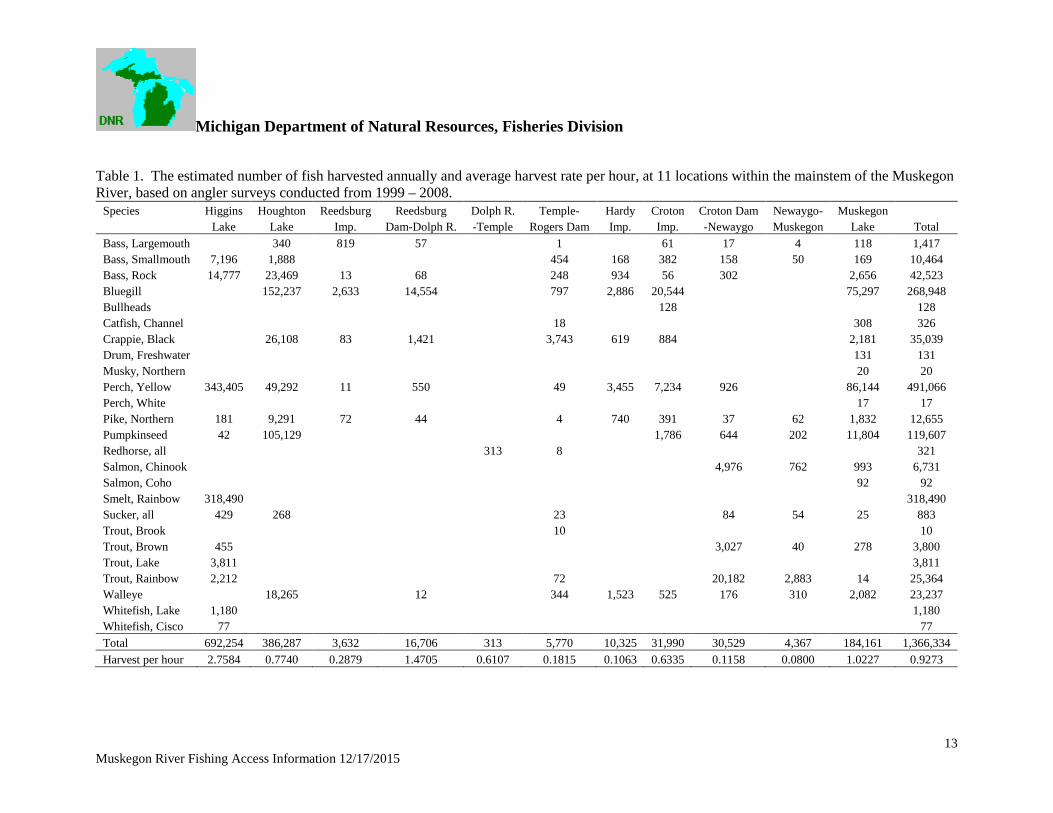
Michigan Department of Natural Resources Fisheries Division
Muskegon River Fishing Access Information 12172015 15