muscle shoals reservation pond creek levee …
TRANSCRIPT

Document Type: EA-Administrative Record Index Field: Environmental Assessment Project Name: Muscle Shoals Reservation
Pond Creek Levee Project Project Number: 2014-22
MUSCLE SHOALS RESERVATION POND CREEK LEVEE
ENVIRONMENTAL ASSESSMENT Colbert County, Alabama
Prepared by: TENNESSEE VALLEY AUTHORITY
Knoxville, Tennessee
July 2014

This page intentionally left blank

Environmental Assessment
1
The Proposed Decision and Need
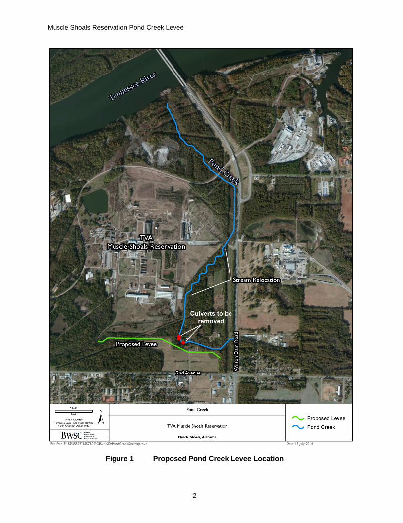
In 1973, the Tennessee Valley Authority (TVA) executed an agreement with the City of Muscle Shoals to maintain the Pond Creek levee located in the southeast corner of the Muscle Shoals Reservation (MSR) in Colbert County, Alabama. The levee consists of 2,400 linear feet of constructed earthen embankment and 3,200 linear feet of an abandoned railroad track embankment. Recent research for the future sale of a portion of the MSR indicated that the levee is in poor condition and is in need of repair to function as intended. Because of environmental concerns associated with restoring the existing levee, TVA is proposing to construct a new levee 75 to 150 feet south of the existing Pond Creek Levee on the MSR (Figure 1). Soil excavated during the Pond Creek Relocation project (downstream) would be used to construct the proposed levee. The levee construction would include the installation of a through-drainage system using pipes and one-way check valves. TVA is also proposing to reduce flooding upstream of Roosevelt Drive by removing three structures (i.e., culverts) (Figure 1). If needed, TVA would provide sufficient land rights on the MSR (i.e., permanent easement) to the city of Muscle Shoals to facilitate its maintenance of the new levee.
The proposed levee is necessary to fulfill TVA’s commitments in the 1973 agreement with the City of Muscle Shoals. The proposed removal of three culverts and the construction of the new levee would also reduce flooding upstream of Roosevelt Drive. This improvement would meet the Federal Emergency Management Agency (FEMA) requirements for the 100-year flood event.
Scope of Environmental Review
TVA has prepared this EA to comply with the National Environmental Policy Act (NEPA) and its implementing regulations. TVA considered the possible environmental effects of the proposed action and determined that potential effects to the environmental resources listed below were relevant to the decision to be made. Thus, potential effects to surface water, floodplains, cultural resources, wetlands, threatened and endangered species, aquatic ecology, and terrestrial ecology (vegetation and wildlife) are addressed in detail in this EA.
TVA also considered potential effects related to socioeconomics and environmental justice; health and safety; natural areas, solid and hazardous waste; recreation; air quality; visual resources; geology and soils; navigation; groundwater; noise; transportation; and global climate change. TVA found these potential effects to be absent or minor; thus, these resources do not require further evaluation.
The disposal and redevelopment of the MSR and the relocation of Pond Creek are outside the scope of this EA, but were evaluated in the MSR Redevelopment Final EIS (TVA 2011) and the Solid Waste Management Unit 108 – Pond Creek Relocation Final EA (TVA 2013), respectively. However, consistent with the Council of Environmental Quality’s regulations and guidance, TVA has assessed the cumulative impacts of these projects.
Muscle Shoals Reservation Pond Creek Levee
2
Figure 1 Proposed Pond Creek Levee Location
Environmental Assessment
3
Other Environmental Reviews and Documentation
Documents that influenced the scope of this EA include:
Solid Waste Management Unit 108 – Pond Creek Relocation Final Environmental Assessment (TVA 2013), documented the potential environmental effects of the reshaping and relocation of a half-mile section of Pond Creek away from the eastern side of solid waste management unit 108 on the MSR. The proposed action being reviewed in this EA would utilize the excavated material from the Pond Creek Relocation for the construction of the new levee. TVA would also relocate the excavated material not used in the levee construction to two different stockpile locations.
Muscle Shoals Reservation Redevelopment Final Environmental Impact Statement (TVA 2011). This EIS documented the potential environmental effects of the proposed sale of 1,400 acres of land on the MSR in Colbert County, Alabama. The proposed project area being reviewed in this EA is located within the area evaluated in the EIS.
Permits, Licenses, and Approvals
The proposed action would be subject to the following environmental permit requirements and regulations.
Alabama Department of Environmental Management General National Pollutant Discharge Elimination System (NPDES) Permit for stormwater discharge associated with construction activity.
ADEM Construction Best Management Practices Plan (CBMPP) to outline effective erosion and sediment controls for the General NPDES Permit.
U.S. Army Corps of Engineers (USACE) Section 404 Permit for discharge of fill material in waters of the United States (Pond Creek).
Water quality certification under Section 401 of the Clean Water Act.
Alternatives
Preliminary internal scoping by TVA has determined that from the standpoint of NEPA, there are two alternatives available to TVA: the No Action Alternative and the Proposed Action Alternative
No Action Alternative Under the No Action Alternative, TVA would not construct a new Pond Creek levee. TVA would also not remove three culverts along Pond Creek to improve flooding upstream or use excavated material from the relocation project. The existing Pond Creek levee would remain as is, which would violate TVA’s 1973 agreement with the City of Muscle Shoals. The current flooding that occurs upstream of Roosevelt Drive would also continue. The excavated material from the Pond Creek relocation project would be placed in the 9-acre stockpile location as originally proposed in the 2013 EA. Although TVA would not knowingly violate its agreement with the City of Muscle Shoals, TVA has chosen to characterize the current state of the existing levee without restoration or maintenance as

Muscle Shoals Reservation Pond Creek Levee
4
the No Action Alternative to provide a benchmark to compare the environmental effects of the Proposed Action Alternative.
Proposed Action Alternative Under the Proposed Action Alternative, TVA would construct a new levee 75 to 150 feet south of the existing levee (Attachment A). In April 2014, TVA performed a soil investigation to determine if soil contamination may be encountered during the excavation and relocation of Pond Creek (BWSC 2014). The results of the report indicated that the excavated soil can be treated as non-hazardous and can be stored or used elsewhere on the MSR. Therefore, TVA would use approximately 29,000 cubic yards of excavated soil from the Pond Creek Relocation project to construct the new levee. The new levee would have a 10-foot wide crest with side slopes having a 2:1 (horizontal to vertical) ratio (Figure 2). The levee height varies with a maximum height of approximately 10 feet. TVA would accommodate drainage through the existing levee and railroad embankment by installing a through-drainage system using pipes and one-way check valves. TVA would also breach the existing levee in several locations to prevent water from collecting between the existing levee and the proposed levee. The area of disturbance would be approximately 11.5 acres. TVA would remove obstructions, trees, shrubs, and other woody vegetation within the area of disturbance. The vegetation would be removed to a depth of 18 inches below surface or to the depth at which roots are less than 2 inches in diameter, whichever is greater. All depressions caused by clearing and grubbing activities would be filled with soil material. A vegetative cover using noninvasive, native species would be placed on the newly constructed levee for erosion and sediment control.
Figure 2 Typical Levee Section
The new levee would be constructed to meet FEMA requirements for certified levees. TVA would also contact the local floodplain administrator to determine the actions necessary to ensure compliance with local floodplain regulations.
TVA would also remove and demolish three culverts downstream of the new levee. The removal of culverts would require excavation within Pond Creek and the placement of rip-rap of 2:1 side slopes to stabilize the area. TVA would obtain the necessary state and federal permits for the proposed action. TVA is also proposing to place the excavated soil from the Pond Creek Relocation project not used for construction of the levee in two stockpile locations on the MSR (Figure 3). Placing the soil in these locations is different than what was evaluated in the MSR Pond Creek 2013 EA. The stockpile locations have

Environmental Assessment
5
been sited outside floodplains and wetlands limits. The stockpiles would be approximately 15 feet or less in height. TVA would establish vegetation on the stockpiles by seed. The stockpiles would also be stabilized and TVA would use proper BMPs for erosion and sediment control.
TVA would need to remove an undetermined amount of vegetation, including trees and other plant material due to the levee construction within the limits of disturbance. Marketable timber would be salvaged where feasible; otherwise, woody debris and other vegetation would be piled and burned, chipped, taken off site or used on-site to serve as erosion protection and sediment control. No state burn permit is required, but TVA would follow local requirements prior to burning and ensure no trash is burned (TVA 2012).
Figure 3 Proposed Stockpile Locations
Other Alternatives Not Considered in Detail TVA performed an alternatives analysis in April 2014 and identified the three options listed below to honor its commitment to the City of Muscle Shoals (Stantec 2014). TVA also considered restoring the existing levee; however, because the levee was not salvageable due to tree overgrowth (deep roots) and environmental concerns, this option was considered impractical and was dismissed. All options included the use of the soil excavated from the Pond Creek Relocation project (downstream) for construction of a new levee.
1) Remove the existing levee/railroad embankment and construct a new levee along same alignment.

Muscle Shoals Reservation Pond Creek Levee
6
2) Leave the existing levee/railroad embankment and construct a new levee 75 to 150 feet south of the existing levee. The new levee would have a 12-foot wide crest with 3:1 (horizontal to vertical) side slopes.
3) Leave the existing levee/railroad embankment and construct a new levee 75 to 150 feet south of existing levee. The new levee would have a 10-foot wide crest with 2:1 (horizontal to vertical) side slopes.
Option 1 would involve the removal of the existing levee, which would require more clearing of trees and increased potential for wetland impacts. There is also a risk of flooding during construction of the new levee under this option. Implementing Option 2 would likely avoid impacts to wetlands, but construction cost was high and area of disturbance was larger compared to Option 3. Thus, TVA has identified Option 3 as the preferred option. Analysis and documentation of potential effects was based on Option 3.
TVA also conducted an alternatives analysis to determine the best option for the improvement of flooding upstream of Roosevelt Drive (BWSC 2014). TVA considered the following four options.
1) Remove the existing Roosevelt Drive culvert.
2) Replace the existing culvert with a bridge
3) Add a culvert at Roosevelt Drive.
4) Increase the height of proposed levee and remove the three existing culverts.
Option 1 would provide the largest flood reduction upstream, but there would be a permanent loss of access to the MSR from Wilson Dam Road. Option 1 also involves a high cost associated with construction and permitting. Implementation of Option 2 would incur the highest cost and longest construction time. Option 3 would afford the smallest upstream benefits with a potential for clogging of the newly constructed culvert. Implementing Option 4 involves the lowest cost, would maintain access to the MSR, and would increase the 500-year flood elevation approximately 1 to 1.5 feet. Based on cost and upstream benefits, TVA identified Option 4 as the preferred option for improvement of flooding upstream of Roosevelt Drive.
Site Description
The proposed project area is located in the southeast corner of the MSR. It is bounded on the east by Wilson Dam Road, on the south by Second Street, on the west by the existing levee, and on the north by Roosevelt Drive, from about Pond Creek Mile 1.4 to Mile 2.7 (Figure 1). As seen in Figure 1, and according to the MSR final EIS, the project area contains deciduous forest, grassland/herbaceous vegetation, and an area used for pasture/hay. Deciduous forests contain American elm, hackberry, sweetgum, black cherry, and various oaks and hickories. Common understory vegetation includes Japanese honeysuckle, Chinese privet, Virginia creeper, greenbriers, and poison ivy. The pasture/hay field contains grasses such as Bermuda, fescue, Johnsongrass and orchardgrass. The two proposed stockpile locations contain pasture/hay fields. Field surveys of the project area were performed during the development of the final EIS in 2010/2011 and again in 2014 for the proposed project.

Environmental Assessment
7
Affected Environment and Evaluation of Impacts
Under the No Action Alternative there would be no changes to the existing environment. Therefore, no changes to surface water, cultural resources, wetlands, threatened and endangered species, aquatic ecology, and terrestrial ecology (vegetation and wildlife) would occur under this alternative. The existing levee would offer some flood protection, but it would neither function as intended nor would it fulfill the 1973 agreement between TVA and the City of Muscle Shoals. Potential impacts from the implementation of the Proposed Action Alternative are discussed in detail below for each resource.
Surface Water
Affected Environment
Pond Creek is located slightly north of the proposed levee and could be affected by the proposed action. Pond Creek flows north through the eastern section of the MSR. This stream had no historical surface connection to the Tennessee River until the 1940s when TVA and the USACE attempted to alleviate local flooding problems. A channel was constructed across the MSR property and connected the stream directly to the Tennessee River approximately 1 mile downstream of Wilson Dam at Tennessee River Mile (TRM) 258.
Sections 305(b) and 303(d) of the Clean Water Act direct states to monitor and report the condition of their water resources. Pond Creek is listed on the most recent 303(d) list for impairment due to organic enrichment and metals (arsenic, cyanide, and mercury) (ADEM 2012). Pond Creek was previously evaluated by ADEM for the former Muscle Shoals Wastewater Treatment Plant (NPDES Permit No. AL0024180). ADEM indicated that the organic enrichment and metals impairment did not appear to be related to nutrient loading. The probable sources for both the organic enrichment and metals impairments are listed as non-irrigated crop production, urban runoff/stream sewers, and natural/wildlife (TVA 2011). For more information about Pond Creek, see Section 3.3.2 in TVA’s 2013 EA.
Environmental Consequences
Proposed Action Alternative Because this proposed project deals with construction activities, constituents naturally occurring in the soil, sediment, and any waste streams produced by construction activities would be the primary potential pollutants to surface water for this project. Additionally, because Pond Creek is an impaired stream, particular attention would need to be given to avoid making poor water quality conditions worse or contaminating the new stream location.
The proposed action would include clearing approximately 11 acres to construct the new levee. Soil disturbances associated with construction activities could potentially result in water quality impacts because exposed soils are more prone to erosion from rainfall and wind. If not controlled by appropriate construction BMPs, excess runoff could enter nearby surface waters, causing siltation and a degradation of water quality. The proposed actions would be performed in a manner to minimize these potential impacts.
The removal of three culverts would require excavation and the placement of rip-rap within Pond Creek. BMPs would be implemented to ensure the removal of culverts and the stockpiled sediment would not adversely impact surface water. TVA would comply with all appropriate local, state, and federal permit requirements. More specifically, a Notice of Intent would be submitted to ADEM for coverage under the General NPDES Permit for

Muscle Shoals Reservation Pond Creek Levee
8
Discharges of Stormwater Associated with Construction Activities. As part of this application, a CBMPP would be developed and implemented to control and confine sediment to the project area. This plan would identify specific BMPs to address construction-related activities that would be adopted to minimize storm water impacts. The BMPs that would be utilized for this project would include, but not be limited to, the following measures.
• Construction entrances and exits would be constructed or an existing road would be utilized at all points of entry and exit from the site to reduce any sediment leaving the site on vehicle tires.
• Silt fencing, rip rap check dams, and buffer zones would be utilized as perimeter and outlet protection.
• Vegetative cover would be established on all denuded areas. Where soil disturbance would occur, the area would be stabilized and vegetated with native or non-native, non-invasive grasses and mulched, as described in A Guide for Environmental Protection and Best Management Practices for Tennessee Valley Authority (TVA 2012).
With the performance of the construction activities in accordance with all permit requirements, the associated impact on the quality of the receiving waters would be minimized. The proposed action is not expected to increase any pollutant contamination currently listed on the 303(d) list for this area. Under the Proposed Action Alternative, the construction activities and placement of excavated soil is expected to result in minor and temporary direct and indirect impacts to surface waters during construction. Any discharges/waste streams into surface waters would comply with all ADEM permit limits.
Floodplains
Affected Environment
A floodplain is the relatively level land area along a stream or river that is subjected to periodic flooding. The area subject to a one percent annual chance of flooding (100-year flood) in any given year is normally called the 100-year floodplain. For certain “Critical Actions”, the minimum floodplain of concern is the area subject to inundation from a 500-year (0.2 percent annual chance) flood. “Critical Actions” are those for which even a slight chance of flooding would be too great.
Pond Creek has a drainage area of about 22 square miles (TVA 2011), and enters Pickwick Reservoir at TRM 258. Portions of the proposed project would cross the 100 year floodplain of Pond Creek (Attachment B). Based on Map Number 01033C0144D of the February 17, 2010, Colbert County Flood Insurance Rate Map, the three culverts to be removed and portions of the proposed levee would be located within the 100-year floodplain of Pond Creek. Colbert County participates in the National Flood Insurance Program, and any development must be consistent with these regulations.
Environmental Consequences
As a federal agency, TVA is subject to the requirements of EO 11988, Floodplain Management. The objective of EO 11988 is “…to avoid to the extent possible the long- and short-term adverse impacts associated with the occupancy and modification of floodplains and to avoid direct and indirect support of floodplain development wherever there is a

Environmental Assessment
9
practicable alternative” (United States Water Resources Council 1978). The EO is not intended to prohibit floodplain development in all cases, but rather to create a consistent government policy against such development under most circumstances. The EO requires that federal agencies avoid the 100-year floodplain unless there is no practicable alternative. For certain “Critical Actions”, the minimum floodplain of concern is the area subject to inundation from a 500-year (0.2 percent annual chance) flood.
Proposed Action Alternative The proposed soil stockpiles would be located outside the 100-year floodplain. Removing the culverts and constructing the levee are not considered to be repetitive actions in the 100-year floodplain; however, they are functionally-dependent uses of the floodplain. Thus there is no practicable alternative to performing these actions in the floodplain. TVA published a no practicable alterantive notice in the local paper and received no comments.
TVA would accommodate drainage through the existing levee by installing a through-drainage system using pipes and one-way check valves. Removing the three culverts would reduce 100 year flood elevations at Roosevelt Drive. The new levee would be constructed to meet FEMA requirements for certified levees. Therefore, the proposed project would be consistent with EO 11988. However, no levee can absolutely guarantee protection from flooding. There is always the chance that a levee will fail and flooding will occur (ASCE 2010). Structures south of Second Street may be impacted by a levee failure.
The cumulative floodplain impacts of the proposed project would be beneficial. By conforming to FEMA requirements, the levee would reduce flood risk for homes, businesses, and infrastructure south of Second Street. TVA would contact the local floodplain administrator to determine the actions necessary to ensure compliance with local floodplain regulations.
Based upon compliance with federal and local floodplain regulations, the proposed construction of a new levee just south of the existing levee, removal of three culverts, and two soil stockpiles would have beneficial and no adverse impacts on floodplains.
Wetlands
Affected Environment
In February 2012, a field survey and wetland assessment was completed for the entire MSR as part of the redevelopment project (Figure 4). Twenty-one wetlands were identified within the boundaries of the MSR. These areas are primarily forested wetlands associated with low-lying areas and floodplains. There are no wetlands located in the project area.
Environmental Consequences
Proposed Action Alternative The proposed Pond Creek levee and soil stockpiles have been sited to avoid wetlands. There would be indirect effects to wetlands associated with removal of the three downstream culverts. The potential wetland impacts from the removal of the culverts would be temporary, and offset by the floodplain/riparian wetlands that will be created in association with the mitigation requirements for the Pond Creek relocation project. There would be minor indirect impacts associated with the implementation of the Proposed Action Alternative.

Muscle Shoals Reservation Pond Creek Levee
10
Figure 4 Delineated Wetlands Located on the Muscle Shoals Reservation

Environmental Assessment
11
Aquatic Ecology
Affected Environment
As previously stated, Pond Creek is located just north of the proposed new levee. Currently Pond Creek is classified as Agricultural and Industrial Water Supply by ADEM and identified as a tier 1 stream with no total maximum daily load limits. It is also listed on the ADEM 303(d) list for impairment. Impaired waters are those that do not presently fully support their designated uses. The most recent TVA aquatic life survey of Pond Creek (TVA unpublished data 2007) and a 2014 field survey of the new levee location support this listing. While Pond Creek has adequate physical habitat, both the fish and benthic macroinvertebrate community conditions indicated severe impairment of this stream. No invasive fish or other aquatic life is known from or reported from Pond Creek.
Environmental Consequences
Proposed Action Alternative The construction of the proposed new levee would occur on backlying land and no direct impacts to Pond Creek are anticipated. The new levee would include the installation of a through-drainage system using pipes and one-way check valves. Therefore, impacts to water flow would be minor. Direct and indirect impacts to the stream channel and stream banks of Pond Creek would occur from the removal of the three downstream culverts and bank stabilization via riprap and re-sloping. However, ground disturbance would be minimized and all work done in accordance to BMPs as outlined in federal and state permit conditions. The proposed actions would not contribute to the spread of exotic or invasive aquatic species or unique/important aquatic habitats. Minor impacts to aquatic life would occur under the Proposed Action Alternative.
Vegetation
Affected Environment
As previously stated, the project area contains deciduous forest, grassland/herbaceous vegetation, and an area used for pasture/hay. Much of the native vegetation within the project area has been altered by previous land use history. According to EDDMaps (2013), there are 73 invasive species reported from Colbert County. Commonly encountered species include cogongrass, kudzu, mimosa, Chinese privet, crown vetch, Japanese honeysuckle, callery pear, and tree-of-heaven. No uncommon plant communities are known from the vicinity and no rare plant communities occur in the project area.
Environmental Consequences
Proposed Action Alternative The proposed project would involve clearing deciduous forest habitat in order to construct the new levee. Trees proposed for removal are common and representative of this community type. Therefore, impacts to this community type, while adverse, would be minor. The proposed action would not significantly contribute to the spread of exotic or invasive species because the project area currently contains a sizable proportion of non-native, invasive species. These non-native, invasive species are distributed widely throughout the region, and implementation of the proposed project would not change this situation.
The MSR redevelopment project and the relocation of Pond Creek would also result in additional long term loss of forest in certain areas on the MSR. Therefore, there is a

Muscle Shoals Reservation Pond Creek Levee
12
potential for minor contribution of cumulative impacts to botanical resources as a result of the proposed action.
Wildlife
Affected Environment
The project area is surrounded by early successional fields, industrial buildings, fragments of forest, residential neighborhoods, and transportation corridors. The proposed stockpiles are located in early successional fields and developed areas surrounded by industrial development in the center of the MSR.
The project area contains habitat used by common terrestrial species identified and discussed in the 2011 final EIS and the 2013 EA. The Pond Creek riparian corridor serves as habitat for both resident and migrant species of birds. Bat surveys were performed by TVA staff in July 2007 over this section of Pond Creek (Figure 3-27 of 2011 final EIS). Species captured included big brown bat, gray bat, northern red bat, and tricolored bat.
A July 2013 review of the TVA Natural Heritage database indicated that five caves are reported within three miles of the project area. The closest of these is approximately 0.9 miles away from the project area. There are no records of heronries within 3.0 miles of the project area. No habitats unique or important to terrestrial animals are known from within three miles of the proposed project.
Environmental Consequences
Proposed Action Alternative The proposed project would involve clearing forested habitat in order to construct the new levee. This action would displace breeding birds and resident mammals, reptiles, and amphibians utilizing the site. Suitable habitat exists for these animals in nearby parcels of forest on and off the MSR. The new levee would be re-vegetated with non-invasive, native grasses. Overall, minor temporary direct and indirect impacts to the local wildlife community are anticipated under the Proposed Action Alternative.
Activities associated with the proposed project would not impact unique or important terrestrial habitats. Activities associated with the proposed project would not affect wading bird colonies or other aggregations of migratory birds. Based on review of the actions and site location information, the proposed project would not contribute to the spread of exotic or invasive terrestrial animal species.
Threatened and Endangered Species The Endangered Species Act (ESA) requires federal agencies to conserve listed species and to determine the effects of their proposed actions on endangered and threatened species and their critical habitat. Endangered species are those determined to be in danger of extinction throughout all or a significant portion of their range. Threatened species are those determined to be likely to become endangered within the foreseeable future. Section 7 of the ESA requires federal agencies to consult with the U.S. Fish and Wildlife Service (USFWS) when their proposed actions may affect endangered or threatened species and their critical habitats.

Environmental Assessment
13
Affected Environment
Aquatic Species
According to the 2013 EA, 28 federally listed endangered species, two proposed endangered species, one proposed threatened species, one federally listed threatened species, and 48 additional state-listed species are known to occur within a ten-mile radius of the project area (Table 1 of Attachment C). No suitable habitat for any listed species occurs within the project area.
Wildlife Species
A July 2014 review of the TVA Natural Heritage Database indicated that one state listed, one federally protected, and one federally listed species have been documented within three-miles of the project area (Table 2 of Attachment C). One additional federally listed species has been reported from Colbert County, Alabama. The USFWS has determined that the federally endangered Indiana bat and the northern long-eared bat (proposed for listing as federally endangered) both have the potential to occur in northern Alabama. Thus, potential impacts to these species were evaluated.
Alligator snapping turtle is protected by the state of Alabama. This aquatic species is restricted to drainages, floodplains, swamps, and oxbow lakes associated with large rivers, only emerging from water for nesting and basking. Suitable habitat for this species does not exist within the project area.
Bald eagles are protected under the Bald and Golden Eagle Protection Act. They are associated with large mature trees capable of supporting their massive nests. These nests are usually found near larger waterways where the eagles forage. The nearest bald eagle nest record occurs 1.4 miles from the project area (USFWS 2007). No bald eagle nests were observed within or near the project footprint during recent site visits in the area.
The gray bat is a federally endangered species associated year round with caves and roosts in various caves throughout the year. This species emerges from roost sites at dusk to forage for insects along waterways. Three gray bat records exist around the project area, the closest of which is from a 2007 capture approximately 270 feet from the project footprint. These three records are from 2007 mist-net surveys over a stream corridor and in rights-of-way. The nearest cave record occurs 0.9 miles from the project area.
Red-cockaded woodpeckers are a federally endangered species that inhabit open, mature, pine forests with dense, grassy groundcover. Any remaining fragments of this habitat are critical to the recovery of this species. Suitable habitat for red-cockaded woodpeckers does not exist within the project area, and the occurrence record of this species within Colbert County is historical.
Indiana bats inhabit caves during winter and migrate to roost under exfoliating bark and within cavities of trees (typically greater than or equal to 5 inches in diameter) during summer. Foraging occurs along riparian areas and along the tops of trees such as along a forested edge or tree line. Some habitat requirements overlap between Indiana bat and northern long-eared bat, which roosts in caves or cave-like structures in winter, and utilizes cave-like structures as well as live and dead trees with exfoliating bark and crevices in the summer. Northern long-eared bat was proposed in October 2013 for listing as federally endangered by the USFWS. Both bat species have the potential to occur in Colbert County, Alabama, although neither species has been documented in this county or within

Muscle Shoals Reservation Pond Creek Levee
14
10 miles of the proposed project area. Neither species was captured during 2007 bat surveys in the surrounding area. No suitable summer roosting or winter hibernacula habitat exists in the project footprint for either species.
Plant Species
A June 18, 2014 review of the TVA Heritage Database indicated that no federally listed plant species and four state rare plant species are known from within five miles of the project area (Table 3 of Attachment C). Two federally listed plants are known from Colbert County, Alabama. Field work conducted on the MSR in the spring of 2012 indicated that the vast majority of habitat within the project area has been heavily disturbed and is incapable of supporting state or federally listed plant species.
Environmental Consequences
Proposed Action Alternative Aquatic Species
Although several federal and state-listed aquatic species are known from within a 10-mile radius of the proposed project area, none of the species listed in Table 1 of Attachment C is known to occur within Pond Creek. Impacts to species within the Tennessee River (Pickwick Reservoir) would be protected by implementing BMPs and the almost 2.0 miles of Pond Creek that would not be disturbed. With proper implementation of BMPs and the distance to the Tennessee River, no direct, indirect or cumulative impacts to any federal or state-listed aquatic species would occur.
Wildlife Species
No suitable habitat for the alligator snapping turtle, bald eagle, or red-cockaded woodpecker exists within the project area; therefore, no impact to these species would occur. Project activities would not affect gray bat foraging habitat over streams or other bodies of water. No winter hibernacula for this species would be impacted by proposed actions. This species would not be impacted by proposed actions.
Some trees that may offer suitable foraging habitat for Indiana bat and northern long-eared bat species would be removed as part of the proposed action. However, similar habitat is plentiful in the area, and any effects from loss of foraging habitat would be indiscernible. The proposed actions would not affect Indiana bat. While the northern long-eared bat is proposed for listing, federal action agencies are required to make determinations with respect to whether proposed actions would result in jeopardy to the species based on guidance provided by the USFWS in January 6, 2014. Based on the nature and scope of the project, proposed actions are not anticipated to affect northern long-eared bat.
Plant Species
The state-listed species previously reported from within 5 miles of the project area occupy rich wooded slopes, a habitat not found in the project area. Federally listed species known from Colbert County occur in association with cedar glades, which are typified by exposed limestone bedrock in areas that are naturally devoid of trees. This habitat does not occur within the project area. Therefore, the proposed action would not directly, indirectly or cumulatively affect federal or state-listed plant species.

Environmental Assessment
15
Cultural Resources Historic and cultural resources, including archaeological resources, are protected under various federal laws, including: the Archaeological Resources Protection Act, the Native American Graves Protection and Repatriation Act, and the National Historic Preservation Act (NHPA). Some cultural resources are identified as “historic properties.” A historic property is any prehistoric or historic district, site, building, structure, or object included in or eligible for inclusion in the National Register of Historic Places (NRHP). Section 106 of the NHPA requires federal agencies to consult with the respective State Historic Preservation Officer (SHPO) when proposed federal actions could affect these resources.
Affected Environment
TVA has determined that the area of potential effects (APE) is the footprint of all ground disturbance activities including the location of the proposed levee, culvert removals, and the two stockpile locations. A Phase I cultural resources survey was conducted in the APE for a previous undertaking (D’Angelo et al. 2007). Two non-eligible (1CT574 and 1CT573) and one eligible (1CT575) archaeological sites and NRHP eligible historic structures associated with the MSR and Nitrate Plant were identified near the current APE. However, the APE contains no historic properties listed on, or eligible for, inclusion in the NRHP.
Environmental Consequences
Proposed Action Alternative A Phase I cultural resources survey was conducted for the APE for a previous undertaking (D’Angelo et al. 2007). No historic properties were identified within the APE and the nature of the undertaking is such that it would have no indirect visual effect to historic properties. Pursuant to regulations (36 CFR Part 800) implementing Section 106 of the NHPA, TVA previously consulted with the Alabama SHPO and federally recognized tribes regarding the findings of the 2007 Phase I survey report. The current APE also falls within the larger APE covered in the Memorandum of Agreement between TVA and the Alabama SHPO executed in 2011 for the disposal of land on TVA’s MSR. No direct, indirect or cumulative effects to historic or archaeological resources are anticipated under the Proposed Action Alternative.
Cumulative Impacts The cumulative impacts analysis includes the proposed action, the Pond Creek Relocation project, and the future redevelopment of the MSR. Cumulatively, the projects would alter much of the MSR. The future redevelopment of the MSR would involve clearing vegetation and the construction of buildings, parking lots and other infrastructure. The redevelopment would also involve some preservation of wetlands and forested areas.
Cumulative impacts are discussed for each resource above. Resources that could be affected cumulatively by the proposed action are surface water, floodplains, and terrestrial ecology (vegetation and wildlife). The projects would result in minor cumulative impacts to terrestrial ecology. In order to avoid contribution to degradation of surface water, TVA would use erosion-control BMPs during the proposed action. The implementation of the Proposed Action Alternative would provide beneficial cumulative floodplain impacts.
Mitigation Measures No mitigation measures were identified for the implementation of the Proposed Action Alternative.

Muscle Shoals Reservation Pond Creek Levee
16
Preferred Alternative TVA’s preferred alternative is the Proposed Action Alternative, under which TVA would construct a new Pond Creek levee south of the existing levee and remove three culverts downstream of the levee.
TVA Preparers Elizabeth C. Burton, Terrestrial zoology, Threatened and Endangered Animal species Adam J. Dattilo, Botany, Threatened and Endangered Plant Species Carrie C. Mays, P.E., Floodplains Loretta A. McNamee, Document Preparation and NEPA Compliance Craig L. Phillips, Aquatic ecology, Threatened and Endangered Aquatic Species Kim Pilarski-Hall, Wetlands
Public Involvement TVA published a no-practicable alternative notice in the local newspaper (TimesDaily) on July 9, 2014. The notice described potential wetland and floodplain impacts associated with the proposed action (Attachment D) and provided the public ten days to comment. No comments were received.
References Alabama Department of Environmental Management (ADEM). 2012. Alabama 2012
303(d) List. May 21, 2012. Montgomery, Alabama: ADEM, Water Division, Water Quality Branch. Available online: <http://adem.alabama.gov/programs/water/wquality/2012AL303dList.pdf> (accessed July 6, 2014)
American Society of Civil Engineers (ASCE). 2010. ASCE pamphlet “So, You Live Behind a Levee!” 17 pp.
Barge, Waggoner, Summer and Cannon, Inc. (BWSC). 2014. Report of Pond Creek Relocation Site Excavation Area Soil Profile Sampling TVA Muscle Shoals Reservation, Muscle Shoals, Alabama. April 2014. Prepared for TVA. BWSC Project Number: 3557803
D’Angelo, J.D., G. Henry, and J. Holland. 2007. Cultural Resources Survey of 1,040-Acre Muscle Shoals LUP Tract in Colbert County, Alabama. Atlanta, Georgia: TRC. Report submitted to TVA.
EDDMaps. 2013. Early Detection & Distribution Mapping System. The University of Georgia – Center for Invasive Species and Ecosystem Health. Available online: <http://www.addmaps.org> (accessed June 24, 2014).
U.S. Water Resources Council. 1978. Floodplain Management Guidelines For Implementing E.O. 11988, U.S. Water Resources Council, 43 FR 6030, February 10, 1978.
Stantec 2014. Pond Creek Levee Restoration Alternatives. April 29, 2014.

Environmental Assessment
17
Tennessee Valley Authority. 2011. Muscle Shoals Redevelopment Final Environmental Impact Statement. Available online: <http://www.tva.gov/environment/reports/muscle_shoals/index.htm> (accessed June 15, 2014).
______. 2012. A Guide for Environmental Protection and Best Management Practices for Tennessee Valley Authority Transmission Construction and Maintenance Activities. Revision 2.1- 2012. Tennessee Valley Authority Technical Note TVA/LR/NRM 92/1, Norris, Tennessee.
______. 2013. Solid Waste Management Unit 108 – Pond Creek Relocation Final Environmental Assessment. Available online: <http://www.tva.gov/environment/reports/solid_waste_management/index.htm> (accessed June 15, 2014).
U.S. Fish and Wildlife Service (USFWS). 2007. National Bald Eagle Management Guidelines. May 2007. Available online: <http://www.fws.gov/southdakotafieldoffice/NationalBaldEagleManagementGuidelines.pdf> (accessed July 1, 2014)
Attachments A – Pond Creek Levee Drawings
B - Muscle Shoals Reservation Floodplain Maps
C - Threatened and Endangered Species List
D – No Practicable Alternative Public Notification