mtbaker culvert eia w08
TRANSCRIPT

8/14/2019 MtBaker Culvert EIA W08
http://slidepdf.com/reader/full/mtbaker-culvert-eia-w08 1/40
Environmental Impact AssessmentFor
Mt. Baker Highway Culvert ReplacementAddressing WSDOT-Identified Chronic Environmental Deficiencies
Prepared by
Krista Chavez
Nate Lundgren
Erin Smart
Jake Sullivan
This report represents a class project that was carried out by the students of Western Washington
University – Huxley College. It has not been undertaken at the request of any persons
representing local government or private individuals. Nor does it necessarily represent the
opinion or position of individuals from government or the private sector.

8/14/2019 MtBaker Culvert EIA W08
http://slidepdf.com/reader/full/mtbaker-culvert-eia-w08 2/40
Table of Contents
DEAR CONCERNED CITIZEN LETTER…………………………………………….....3
FACT SHEET……………………………………………………………………………..4
INTRODUCTION………………………………………………………………………...6
PROJECT AREA SITE MAP…………………………………………………………..…7
TOPOGRAPHIC MAP OF PROJECT AREA…………………………………………....8
PROPOSED ACTION AND ALTERNATIVES…………………………………………9
EROSION MITIGATION……………………………………………………………….10
ENVIRONMENTAL MATRIX…………………………………………………………13
PLANS AND PROFILES…………………………………………………………..……14
SCOPING PROCESS……………………………………………………………………19
NATURAL ENVIRONMENT………………………………………………………..…20
Earth……………………………………………………………………………...20
Air……………………………………………………………………………..…22
Water…………………………………………………………………………..…23
Plants…………………………………………………………………………..…25
Animals………………………………………………………………………..…26
Environmental Health……………………………………………………………29
BUILT ENVIRONMENT………………………………………………………….……31
Aesthetics……………………………………………………………………...…31
Public Services and Utilities……………………………………………………..32
Transportation……………………………………………………………………33
LIST OF TECHNICAL TERMS…………………………………………………...……34
APPENDIX A: Fauna species list…………..………………………………………...…36
APPENDIX B: Flora species list………………………………………………………...37
REFERENCES………………………………………………………………………..…38
2

8/14/2019 MtBaker Culvert EIA W08
http://slidepdf.com/reader/full/mtbaker-culvert-eia-w08 3/40
March 5, 2008
ESCI 436
Mt. Baker Culvert Replacement Team
Huxley College of the Environment
Concerned Citizens
Whatcom County, Washington
Dear Concerned Citizen,
The following Environmental Impact Assessment (EIA) was developed by students of Huxley
College of the Environment at Western Washington University. Although official State studies
were used in compiling the information, by no means is this an official document. An EIA is
meant to emulate an Environmental Impact Statement; a document of research required by the
state Environmental Policy Act to assess the impacts of a proposed measure.
This EIA addresses the current work being done by the Washington State Department of Transportation (WSDOT) in an effort to replace stream culverts on Mt. Baker Highway in
Whatcom County, Washington. Our study focuses specifically on the present and proposed
culverts over Bruce and Baptist Creek. We attempted to address all potential concerns regardingthe public and environmental habitat fully. Included in this EIA are discussions on the proposed
actions of WSDOT and possible alternatives that can improve upon both existing conditions and
future environmental and social impacts. Our hope is that this document might clarify and
expand upon the work being done by the WSDOT.
Sincerely,
The Mt. Baker Highway Culvert Replacement Team
Krista Chavez
Nate Lundgren
3

8/14/2019 MtBaker Culvert EIA W08
http://slidepdf.com/reader/full/mtbaker-culvert-eia-w08 4/40
Erin Smart
Jake Sullivan
Fact Sheet
Project Name
Mt. Baker Highway Culvert Replacement: Addressing WSDOT-identified Chronic
Environmental Deficiencies
Project Description
This project includes road safety improvements, culvert replacement, and stream
realignment at two separate locations on SR 542 in Whatcom County.
Description of Location
Location 1 includes Bruce Creek located 2.25 miles east of Maple Falls and extends from
mile post (MP) 27.90 to MP 28.10.
Location 2 includes Baptist Creek and located 3.00 miles east of Maple Falls and extends
from MP 28.66 to MP 28.73.
Proposer
Washington State Department of Transportation – Northwest Region
Lead Agency
ESCI 436 Environmental Impact Assessment students of Huxley College at Western
Washington University
Permits
Hydraulic Project Approval WA Dept. of Fish & Wildlife
NPDES General Construction Permit WA Dept. of Ecology
Section 404 Permit US Army Corps of Engineers
Section 401 Water Quality Certification WA Dept. of EcologyClearing Permit Whatcom County
Critical Areas Review Whatcom County
4
8/14/2019 MtBaker Culvert EIA W08
http://slidepdf.com/reader/full/mtbaker-culvert-eia-w08 5/40
Contributors Krista Chavez: earth, aesthetics, mitigation efforts
Nate Lundgren: water, animals, introduction
Erin Smart: environmental health, air, traffic, photos, maps, editor Jake Sullivan: plants, public services and utilities
Public Hearing Held
Community Food Co-op Community Building – 1220 N. Forest
March 10, 2008 at 2:00 pm
Special Thanks to
Alan Soicher, contact personMaria Mayrhofer, Environmental Coordinator III, NWR Environmental ProgramWSDOT
Leo Bodensteiner
5

8/14/2019 MtBaker Culvert EIA W08
http://slidepdf.com/reader/full/mtbaker-culvert-eia-w08 6/40
Introduction
Bruce Creek and Baptist Creek are small tributary streams to the North Fork of the
Nooksack River in Whatcom County. Both of the creeks run underneath SR 542, a well
used roadway with year-round access to recreation opportunities at the Mt. Baker Ski
area and the Mt. Baker-Snoqualmie National Forest. The creeks are two of many thathave been redirected through culverts since the road was built. At the time of
construction, there were few environmental concerns regarding the diversion and
manipulation of streams and rivers. With the science available today it is clear that thereare serious impacts on the stream ecology and morphology due to such activities and
these impacts were not considered when the culverts were put in place. Of particular
importance today in Washington is the restoration of native salmon populations whichincludes reestablishment of the species to their historical range. Removal of migration
barriers such as the culverts on Bruce Creek and Baptist Creek that restrict the movement
of salmonids is part of the strategy to improve the overall health of salmon stocks in
Washington.
In 1991 Washington State Department of Transportation created the Fish Passage Barrier
Removal Program with the goal of identifying and removing fish passage barriersthroughout the state (WSDOT 2008a). The Baptist Creek culvert has been identified as
such a barrier and is scheduled for replacement under the program. In 2004 another
Department of Transportation program named the Chronic Environmental Deficiencies program was established. The purpose is to identify roadway structures along state
highways where frequent maintenance of the structure has had harmful effects on fish
habitat (WSDOT 2008b). Bruce Creek falls under this program as it requires frequentdredging to maintain proper flow through the culvert. Replacing these two culverts will
improve the ecosystem health and restore proper morphological functions of the creeks
and the Nooksack River watershed as a whole.
6

8/14/2019 MtBaker Culvert EIA W08
http://slidepdf.com/reader/full/mtbaker-culvert-eia-w08 7/40
Project Area Site Map
7

8/14/2019 MtBaker Culvert EIA W08
http://slidepdf.com/reader/full/mtbaker-culvert-eia-w08 8/40
8

8/14/2019 MtBaker Culvert EIA W08
http://slidepdf.com/reader/full/mtbaker-culvert-eia-w08 9/40
Proposed Action and Alternatives
Proposed Action
Bruce Creek The project will remove the existing culvert and replace it with a box culvert. The new
box culvert will be placed in the historical alignment of Bruce Creek (80 feet west of
existing culvert), before the current culvert was put in place. The box culvert that is to be put in place is approximately 65 feet in length and will result in 450 feet of stream being
realigned. The realignment will result in an increased grade, allowing for more substrate
to pass downstream without obstruction. The current culvert is at too low of a grade, and
is placed below the existing creek grade. Repeated dredging is required to remove the bed load that accumulates from the bottleneck created by this culvert. The replacement
has the potential to allow fish to access the habitat above SR 542 which is currently
inaccessible. SR 542 will be realigned for approximately 900 feet to accommodate the
new culvert. A six-foot shoulder on the westbound side and a ten-foot shoulder on theeastbound side will be constructed to upgrade the area for pedestrian use. Because
17,830 square feet of impervious surfaces are to be created from this project storm water treatment will be included. Best management practices for storm water treatment include
biofiltration swales, ecology embankments and infiltration trenches, all of which will be
used to treat the runoff from these impervious surfaces.
Baptist Creek
The culvert replacement on Baptist Creek will remove the existing concrete pipe and
replace it with a box culvert. The current culvert is not a barrier to fish passage, but the box culvert that is to be put in its place will increase the amount of sediment allowed to
pass, and will mitigate the increased peak flows created by the current 18 inch diameter
pipe. One tributary of Baptist Creek runs along SR542 for about 250 feet, this sectionlacks riparian vegetation and receives untreated runoff from SR542. This section of
stream is to be moved 40 feet to the north, within the private property of the Baptist
Camp. No impervious surface is to be added during this project because the new culvertis in the same place as the existing one, and no road realignment will be necessary.
Alternatives
Alternative A: Bridge
Alternative A would consist of replacing the culverts on Bruce Creek and Baptist Creek
with bridges. Washington Department of Fish and Wildlife prefers this approach as bridges generally have less of a detrimental effect on fish and the stream ecology in
general. A bridge becomes a more reasonable option for wider streams or streams of a
steeper gradient. Though a bridge is generally less deleterious for a given stream or river than a culvert is, installation of a bridge is not without environmental impacts and
mitigation measures would still need to be taken. Of particular concern is the possibility
that after a culvert is removed the upstream portion of the channel may be vulnerable to
9

8/14/2019 MtBaker Culvert EIA W08
http://slidepdf.com/reader/full/mtbaker-culvert-eia-w08 10/40
erosion. Sediment and debris that have accumulated in front of the culvert over time can
become unstable and give way, necessitating some type of grade control (WDFW 2003).
Alternative B: No Action
Alternative B would allow Bruce and Baptist Creek to persist in their present state. Both
creeks could potentially perform important ecosystem functions that are not taking placeat this time. Concern over salmonid fish is a major consideration regarding the direction
of this project. Many salmonid populations in Western Washington are in jeopardy and
three species are listed as threatened. Both creeks have historically provided suitablehabitat for certain species of salmon and trout but currently Bruce Creek is impassable for
fish and Baptist Creek is only partially fish passable (Maria Mayrhofer, WSDOT, pers.
comm. 2008). As well as allowing the creeks ecological capabilities to remain
unrealized, no action would also require that time and money continue to be spentdredging sediment from the stream beds to prevent the culverts from clogging during
rainstorms (WSDOT 2007).
Erosion Mitigation
The construction practices involved in culvert replacement and road realignment require
invasive activity within fragile ecosystem boundaries. All activities in these areas will
create temporary to long term habitat deficiencies. According to a study on Marylandconstruction runoff, construction sites with no erosion or sediment controls have an
increase of over 1000 times the rate of erosion compared to natural conditions (WSDOT
Training Manual, 2005). It is necessary to address practices which will allow for themitigation of adverse erosive impacts caused by construction.
Various Best Management Practices have already been cited for use by WSDOT.Currently, the project plans regarding the proposal for Bruce Creek involves the additionof over 17,000 square feet of impervious surface to the area. Any action involving the
addition of more than 2,000 square feet of impervious surface is subject to creating a
Temporary Erosion and Sediment Control Plan (TESC). A TESC consists of twelveelements which can be seen in Table 1 and are to be followed throughout the duration of
construction action. The following are various cited mitigation measures and brief
explanations for the proposed actions involved in the culvert replacements on Bruce andBaptist Creek. They do not represent a complete or official TESC, but is to be used as an
aid in understanding the processes and carefully thought out plans to carry out the
proposals.
In an effort to curb impacts from the movement of machinery to and from the
construction site, WSDOT will practice stabilizing construction entrances (WSDOT,
2007). Stabilized entrances generally require the use of stones to provide stability at theloading, and unloading location. The rocks reduce the amount of contact between the
machinery and the soil faces which benefits the environment in two key areas. First, by
reducing the amount of soil on the machinery as it leaves the work site decreases theamount of soil transplanted on the highway surface thus reducing the amount of potential
10
8/14/2019 MtBaker Culvert EIA W08
http://slidepdf.com/reader/full/mtbaker-culvert-eia-w08 11/40
sedimentation into the nearby stream (WSDOT Training Manual, 2005). The second key
benefit to using stones at the construction entry way is the increased surface area of the
soil particles in the topsoil and increased permeability will improve drainage—decreasing potential for rutting and saturation of the immediate topsoil (Schaetzle, 2005).
The next measure of erosion mitigation proposed is the use of rock check dams. Thesedams are utilized to reduce the velocity of water flows that become concentrated in
drainage ditches (Salt Lake County, 1999). During construction, flows become
increasingly full of sediment due to excavations and soil exposure. By reducing thevelocity and creating small pools in the stream, these check dams enable the sediment to
successfully settle behind the dam, thus removing it from the drainage flow before it
enters into fragile species habitat. Figure1, taken from an erosion training manual of the
WSDOT, shows the design of a rock check dam. The dams would be created out of washed gravel. Unwashed gravel would only add sediment into the flow upon contact
with the stream (WSDOT Training Manual, 2005). WSDOT also cites the use of a
temporary bypass system in combination with a rock check dam to ensure that none of
the water from Bruce or Baptist Creek would be entering into the work site duringconstruction (WSDOT, 2007).
The use of silt fences to protect the surrounding wetlands is a common measure to
mitigate erosion and is one of the proposed practices to be used during construction
(WSDOT, 2007). These fences are created out of a geotextile fabric which are highly
permeable for water movement, but stop the movement of sediment from passing beyondthe barrier (Rhul, et al. AEX-304-97). Silt fences are also very effective in reducing the
velocity of water flow which decreases the potential for scouring or other degradations in
the wetland (WSDOT Training Manual, 2005).
Protecting exposed soils is one of the most important mitigation measures to be utilized
in any project. These soils are completely unshielded to the erosive potential of rainfall,compaction, incoming surface runoff, and soil saturation. The placement of mulch or silt
blankets is commonly used to negate harsh effects caused by the lack of cover and
absence of the stability derived from roots within the soil. The Best ManagementPractice (BMP) to address the issue of exposed soils is to be a plastic blanket covering
(WSDOT, 2007). The benefits from these coverings are two-fold. Placing a non-
permeable layer over the bare soils will prevent rainfall from falling and eroding away
layers of the topsoil into the runoff. These coverings also channel the water into adifferent area with the use of berms so that the soil does not become saturated and prone
to landslide events.
The BMP did not clearly cite whether or not the plastic covering would a clear or a dark,
opaque color. Due to the context to which this material will be placed, the benefits of a
clear covering vastly outweigh the opaque covering. Following construction the areasurrounding Bruce and Baptist Creeks will be replanted with native vegetation. Placing a
clear covering onto the soil will not only allow the transfer of light into the covering, but
provides a greenhouse-like effect which is conducive to the growth of seedlings
(WSDOT Training Manual, 2005). Any seeds or plants currently beneath the soils during
11

8/14/2019 MtBaker Culvert EIA W08
http://slidepdf.com/reader/full/mtbaker-culvert-eia-w08 12/40
construction will profit from the presence of this covering as it could increase growth
rates and ultimately the stability of the soil.
The BMP for Habitat Protection gives a timeline for the amount of time an area of soil
can be exposed during wet and dry seasons. Construction done during the months of
October to June is allowed only two days of exposure before soil is subject to anincreased risk of erosion. During the dryer months, July through September, the soils
may remain exposed for up to seven days (WSDOT, 2005). However, the projected
timeline for our project is slated for anytime between March and August, meaning avariable exposure time. To simplify mitigation processes and reduce overall erosion we
suggest a blanket timeframe of a two-day exposure limit during the duration of
construction.
Finally, the BMP have cited the use of straw mulch or wattles for stormwater filtration
(WSDOT 2007). According to the Erosion Training Manual, wattles, which consist of
various plant materials, can reduce erosion potentials by a factor of four (WSDOT
Training Manual, 2007). As the water flows across the landscape it is intercepted byeither a blanket of straw or a structure composed of straw which forces the water to flow
through the organic material. As it flows though the suspended sediment is filtered out of the water, which reduces the amount of sediment which could potentially degrade a
species habitat. The practice of using straw, specifically in the wattle formation, slows
the velocity of water by breaking the slope into smaller subsections.
Table 1 Temporary Erosion and Sediment Control Plan ElementsWSDOT Training Manual, 2005
Element
Number
Description
1 Mark Clearing Limits
2 Establish Construction Access
3 Control Flow Rates
4 Install Sediment Controls
5 Stabilize Soil
6 Protect Slopes
7 Protect Drain Inlets
8 Stabilize Channels and Outlets
9 Control Pollutants
10 Control Dewatering
11 Maintain Best Management Practices
12 Manage the Project
12

8/14/2019 MtBaker Culvert EIA W08
http://slidepdf.com/reader/full/mtbaker-culvert-eia-w08 13/40
Figure 1 Diagrams the profile and cross section of a rock check dam
(Used WSDOT Training Manual, 2005 as reference)
Environmental Matrix
Proposed Action Alternative A Alternative BHabitat Quality +Improved +Improved Maintained
Ground Water Maintained Maintained Maintained
Water Quality Maintained* Maintained* Maintained
Soil Stability Maintained* Maintained* Maintained
Soil Movement +Improved +Improved -DegradedAesthetics +Improved +Improved -Degraded
Light Maintained Maintained Maintained
Air Maintained* Maintained* Maintained
Environmental Health Maintained* Maintained* Maintained
Plants +Improved* +Improved* -Degraded
Fish Species +Improved* +Improved* -DegradedListed Mammals/Birds Maintained Maintained Maintained
* = temporarily degraded
13

8/14/2019 MtBaker Culvert EIA W08
http://slidepdf.com/reader/full/mtbaker-culvert-eia-w08 14/40
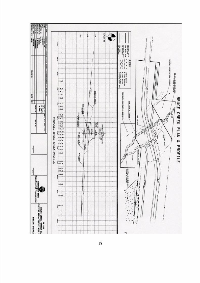
Baptist Camp Creek and Bruce Creek
Locations,
Plans and ProfilesBruce Creek
Baptist Creek
14

8/14/2019 MtBaker Culvert EIA W08
http://slidepdf.com/reader/full/mtbaker-culvert-eia-w08 15/40
15

8/14/2019 MtBaker Culvert EIA W08
http://slidepdf.com/reader/full/mtbaker-culvert-eia-w08 16/40
16

8/14/2019 MtBaker Culvert EIA W08
http://slidepdf.com/reader/full/mtbaker-culvert-eia-w08 17/40
17
8/14/2019 MtBaker Culvert EIA W08
http://slidepdf.com/reader/full/mtbaker-culvert-eia-w08 18/40
18

8/14/2019 MtBaker Culvert EIA W08
http://slidepdf.com/reader/full/mtbaker-culvert-eia-w08 19/40
Scoping Process
Elements of the Environment
A) Natural Environment
i) Earth
ii) Air
iii) Water
iv) Plants
v) Animals and Their Habitat
vi) Environmental Health
B) Built Environment
i) Aesthetics
a) Aesthetics
b) Light and Glare
c) Historic and Cultural Preservation
ii) Public Services and Utilities
iii) Transportation
19

8/14/2019 MtBaker Culvert EIA W08
http://slidepdf.com/reader/full/mtbaker-culvert-eia-w08 20/40
A) Natural Environment
i) EARTH
Geology
The area surrounding the Bruce Creek culvert and Baptist Creek culvert is composed of
unconsolidated sediments, specifically quaternary alluvium and Pleistocene continentalDrift (Schuster, 2005). The quaternary alluvium was deposited by streams or rivers that
once passed through the area during the Pliocene epoch. Their presence along the Nooksack riparian area suggests that the ancient streams developed the river bed that thecurrent stream travels though. The Pleistocene continental drift is from the last major
advance and retreat of the Fraser glacier, which ended about 10,000 years ago
(Easterbrook,1973).
Soils
The soil type surrounding the present Bruce Creek culvert is composed mainly of
Winston Loam while the soil around the creek as it enters into the Nooksack isSnoqualmie gravelly loamy sand. Baptist Creek is composed of three small channels.
The soil surrounding westernmost channel, which runs through the former Baptist Bible
Camp, is Kline gravelly sandy loam. The soil surrounding the middle and easternmostchannel and the culvert is Barneston very gravelly loam (USDA, 1992).
Winston Loam is known for being very deep and well-drained, as with most loams. It is
composed of volcanic ash and loess on top of glacial outwash. The hazard for water erosion in this soil is slight due to the moderate water capacity and moderate to rapid
permeability. The Snoqualmie gravelly loamy sand that surrounds the Nooksack and
immediate riparian area is characterized by its excessively drained soils. The potential
for water erosion is characterized as severe due to slow runoff and the flooding and
20

8/14/2019 MtBaker Culvert EIA W08
http://slidepdf.com/reader/full/mtbaker-culvert-eia-w08 21/40
channeling of the nearby Nooksack River. The water table is 3 to 5 feet in depth from
November to April (USDA, 1992).
Kline gravelly sandy loam is formed on alluvial fans and is characterized by mixedalluvium. This soil is moderately well-drained and is very deep. The upper 11inches are
composed of extremely gravelly loamy sand. The lower 60 inches are composed of a
very gravelly loamy sand and very gravelly sand. The large soil particle sizecharacterized by the soils in both of these layers is very conducive to drainage due to
decreased surface area and largely interconnectedness of interstitial pores. The high
drainage abilities of the soil and low clay content means there is also a very low water capacity. As with the Snoqualmie soil, the water table for the Kline soil is placed at a
depth of about 3 to 5 feet during January to March. The potential for water erosion is
only slight because most of the soil is only subject to occasional and brief floods (USDA,
1992).Barneston very gravelly loam is formed in a mixture of loess and volcanic ash over
glacial outwash typically found on outwash terraces or the slopes between the terraces.
The soil is characterized by excessive-drainage capabilities. Permeability is moderately
rapid in the upper portion, which is composed of very gravelly loam. The lower portionhas very rapid permeability due to the composition of extremely gravelly sand (USDA,
1992). Sand is known for its excellent drainage capabilities due to the high porosity and permeability.
Topography
The slopes mapped around the Bruce Creek culvert are generally low, ranging from 0 to 3 percent. The slopes around Baptist Creek are up to 15 percent (WSDOT, 2007). The
low gradient classifies these slopes as Class 1, indicating that they are stable under most
natural conditions. Further North from Mt. Baker Highway the topography of the land isclassified as Class 3, meaning the ground is marginally stable, but has the potential to
slide along the inclined bedding. The South bank of the Nooksack, in the immediate
vicinity of these two culverts, is a designated Class 4 area. Class 4 slopes are prone tolandslides and are composed of slopes which have previously failed (Easterbrook, 1973).
ENVIRNOMENTAL IMPACTS
The steep slopes on the South bank of the Nooksack suggests that any work done in the
area involving tributary stream flow in the area could possibly have an affect on the
erosive potential of the area in the riparian zone. However, the low stream flows for bothof these creeks will not be enough input to create a hazard for a landslide. According to
the USDA soil survey of the area, the soils in the immediate vicinity of the culvert
replacement have a slight potential for erosion (USDA, 1992).Road construction is a very invasive process. Any soils exposed by a project for an
extended period of time could be subject to erosive forces by rainfall action, which would
increase the surface runoff. Heavy machinery could also increase this risk by compactingthe soil beneath them. The removal of any vegetation during construction would also an
immediate destabilizing effect due to the soil holding capacity of the plan roots. A
reduction in vegetation will also influence the water capacity of the soil and could result
in water erosion.
21
8/14/2019 MtBaker Culvert EIA W08
http://slidepdf.com/reader/full/mtbaker-culvert-eia-w08 22/40
Many construction practices involving road alterations require the use of fill material. In
the event of intense seismic activity, fill material can liquefy and cause a landslide event
or a road failure. Road construction also commonly results in increased impervioussurfaces. Impervious surfaces cause extreme stream-loading and surface runoff during
storm events and could cause water erosion on the soils upslope of the Nooksack.
1) Proposed action
The plans to realign Bruce Creek and Mt. Baker Highway will create obvious
improvements compared to the current conditions. The size of the culvert and grade of the stream is sufficient to allow sediment transport downstream without creating a barrier
to migrating fish species. However, rechanneling the creek greatly increases the potential
for an erosive event. The plans to utilize the excavated material from the new stream bed
as the fill for the old stream bed will ensure that no new, adverse infiltration effectshappen
2) Alternative A: bridge
This proposal is the best in terms of allowing the natural flow of alluvial sedimentsdownstream. However, this project would also require more impervious surfaces and
therefore more opportunities for runoff to erode the surrounding area. Building a bridgewould also require more vegetation to be removed and could result in increased soil
erosive potential.
3) Alternative B: no actionTaking no action would cause the culvert areas to be continually filled with sediment and
require scheduled dredging. The act of dredging could allow fine sediment to wash
downstream and change the streambed properties.
ii) AIR
The site for this project is on a well traveled highway for commuters, workers, and
recreationalists. The air on the highway has increased emissions due to this travel, but
according to the EPA, Washington is at a ‘good’ level of principal pollutants, which are
many fine particles. Construction projects occur often on SR 542, which add to theseemissions. However, due to the remoteness of the site, the air quality is quite good,
especially because of the mountains and river close by to increase air flow through the
area.
ENVIRNOMENTAL IMPACTS
1) Proposed Action
If the proposed action of the culverts were to occur, construction activities could
temporarily increase dust particles due to ground disturbance and engine emission from
construction equipment. However, there are no permanent air quality impacts anticipatedas a result of this project. The contractor will be required to adhere to all applicable
federal, state, and local air quality regulations. These regulations cover temporary
construction conditions such as dust, smoke, and emissions.
22
8/14/2019 MtBaker Culvert EIA W08
http://slidepdf.com/reader/full/mtbaker-culvert-eia-w08 23/40
2) Alternative A: bridge
If a bridge were to be built, the construction activities could temporarily increase dust particles due to ground disturbance and engine emission from construction equipment.
3) Alternative B: no actionIf no action were to take place, the air quality would not be affected.
iii) WATER
Stream Characteristics
Bruce Creek is an approximately 1.5 mile long, second order stream within the Nooksack
River watershed. It is seasonal and is usually dry by late summer. It runs from north tosouth with the headwaters at an elevation of 2,000 feet on the southern side of Black
Mountain. The creek flows through a culvert underneath Highway 542 and continues for
about 0.25 miles before emptying in the Nooksack River at a 600 foot elevation. Near
the headwaters of Bruce Creek the elevation change is very abrupt but becomes moregradually sloped towards the mouth.
Baptist Creek consists of three small tributary streams that converge just north of Highway 542 before running through a culvert underneath the road. One of these
tributary streams runs through the Baptist Camp and is connected to a small pond on the
property. Once crossing the highway the creek continues for 0.25 miles to the Nooksack River.
Habitat Quality
Both of the creeks suffer from degraded riparian and instream habitat. Near the highway
Bruce Creek is periodically dredged due to the accumulation of sediment and debrisdirectly upstream of the culvert (WSDOT 2007). This action prevents the establishmentof diverse habitat structures such as pools. The streambed substrate has been impaired by
the introduction of fine sediments including silt and sand that have entered the watershed
due to forestry activities (WSDOT 2007). Baptist Creek is noticeably lacking in habitat
diversity. Just upstream of the culvert the creek is little more than a roadside ditch,running alongside the highway. Canopy cover is sparse or non-existent and the riparian
zone is dominated by grasses and Himalayan blackberry (Rubus armeniacus).
Ground Water
In Article V under the Whatcom County Critical Areas Ordinance, the watershed area
around the lower reaches of Bruce and Baptist Creek are listed as being within a surficialaquifer of moderate and high susceptibility (WCPDS 2005). The main concern regarding
degradation of groundwater in Whatcom County comes from farming practices which
may introduce nitrates and other contaminants associated with agriculture into the aquifer
(USGS 2006). Such construction projects as culvert replacement would not impactground water, even within a sensitive aquifer.
23

8/14/2019 MtBaker Culvert EIA W08
http://slidepdf.com/reader/full/mtbaker-culvert-eia-w08 24/40
Water Quality
Most of the land within the Bruce and Baptist Creek watersheds is zoned by Whatcom
County as either rural or commercial forestry (WCPDS 2008). Due to past forestryactivities upstream of the creeks, the watersheds have been negatively impacted. Clear-
cut logging reduces the natural ability of the forest to dissipate precipitation and absorb
moisture. This can lead to excess runoff carrying high levels of sediment into the creeks.Primitive logging roads in the area are also likely to contribute to this phenomenon as
mass wasting occurs, washing soil and debris into the stream. It is likely that the water in
Bruce and Baptist Creek both suffer from elevated turbidity, especially during times of heavy rain.
Water quality degradation due to chemical contaminants has not been measured (WSDOT
2007). Because the creeks are located in areas away from human habitation typicallyresponsible for chemical contamination, it is unlikely that Bruce Creek or Baptist Creek
suffer from elevated levels of such contaminants.
CulvertsThere are two culverts in place at the proposed project site, one on Baptist Creek and one
on Bruce Creek. Culverts have the potential to degrade the instream habitat. The water passing through a culvert is restricted by the dimensions of the structure. This reduction
in volume concentrates the flow of the stream and can greatly increase the force of the
water leaving the culvert. This high velocity water has the potential to erode stream
banks and scour the stream beds, carrying and depositing sediment downstream. Besideschanging the stream morphology, these processes can harm aquatic organisms directly or
disrupt their life cycles (WDFW 2003).
ENVIRNOMENTAL IMPACTS
1) Proposed ActionThe construction activities involved in the proposed action are likely to temporarily
degrade the water quality. The heavy equipment used may introduce some sediment into
the creek. This would be mitigated by implementing best management practices (BMPs)during the process such as putting a temporary fence around the stream to keep workers
and equipment out (Maria Mayrhofer, WSDOT, pers. comm. 2008). Habitat restoration
in the riparian zone including planting of native vegetation and the addition of large
woody debris and boulders will help to stabilize the stream banks and improve habitat for the future. In the long-term, water quality will likely be maintained at levels similar to
pre-construction activities and the habitat quality will be improved. It is possible that a
better designed culvert would lead to a slight improvement in the water quality, however most of the factors contributing to any decline in water quality of Bruce and Baptist
Creek probably stem from activities associated with forestry practices further upstream
and not at the site of the culverts at Highway 542. Any improvement could be the resultof less scouring and bank erosion due to the introduction of a properly constructed and
maintained culvert.
24

8/14/2019 MtBaker Culvert EIA W08
http://slidepdf.com/reader/full/mtbaker-culvert-eia-w08 25/40
2) Alternative A: Bridge
If a bridge were put in place rather than a culvert, it is probable that the temporaryenvironmental deterioration associated with that construction process would be greater
than in the culvert alternative. The amount of roadway involved in building a bridge
would simply be greater than the amount used for a culvert. As with the culvertalternative, the water quality would eventually be restored and preserved at levels similar
to pre-construction activities. A bridge however would have the added benefit of
maintaining a higher quality of riparian habitat as the creeks run underneath the highway.
3) Alternative B: No Action
No action would perpetuate the current conditions at the creeks. In the present state, both
creeks are providing less than ideal habitat and habitat functions which could beimproved by stream restoration and replacement of the culvert.
iv) PLANTS
The project area is able to support tree species such as Douglas fir ( Pseudotsugamenziesii
), western redcedar (Thuja plicata)
, western hemlock (Tsuga heterophylla)
, andgrand fir (Abies grandis). These tree species are the dominant types and typical of the
western hemlock vegetation zone. The understory species consist of but is not limited to
salmonberry (Rubus spectabilis), Indian plum (Oemleria cerasiformis), sword fern(Polystichum munitum), and bracken fern (Pteridium aquilinun). Though these aretypical plant species to find in a coniferous forest in the northwest, non-native plants like
reed canarygrass (Phalaris arundinacea) and Himalayan blackberry (Rubus armeniacus)
have invaded the project site and the riparian zone of the streams. (WSDOT 2007)
25
8/14/2019 MtBaker Culvert EIA W08
http://slidepdf.com/reader/full/mtbaker-culvert-eia-w08 26/40
The riparian zone surrounding these streams suffers from logging within the watershed
that has taken place in the past. Reduced large woody debris recruitment and increased
debris flooding are two major side effects of this. Bank erosion and increased sedimentload result from these alluvial processes and have put the streamside vegetation at risk.
The loss in bank stability and the increased peak flows have an amplified effect on
riparian structure and function. With more vegetation loss and increased peak flows,more bank erosion and sediment loading will take place, and a positive feedback has been
established. This loss of a structural habitat has negative effects on the stream itself, but
also reduces the amount of habitat available for both plant and animal species.
ENVIRNOMENTAL IMPACTS
1) Proposed action
The project will effect the riparian vegetation that is currently in the position of the new
culvert for Bruce Creek. Estimated construction processes will affect no more than 20
riparian trees that are greater than 6 inches in diameter, and following the project nativevegetation will be replanted in place of removed vegetation and in place of where the
current culvert is. For Baptist Creek, the only area affected is an open grass field, whichdoes not have the characteristics of a normal riparian zone, thus the impacts of changes
this landscape are negligible. The replanting of native vegetation in this riparian zone
will actually help restore the riparian area of Baptists Creek.
2) Alternative A: bridge – the construction process will likely cause more damage to the
riparian zone. Sediment flow below the bridge will be re-established to historical levels,
and no fish barrier will be present. Road construction and traffic diversion can beexpected to take longer for the construction of a bridge.
3) Alternative B: no action – Substrate will continue to build up at the exit of the BruceCreek culvert and repeated public services will be required to make sure that these
substrate traps be removed and no barrier is present. No riparian functions will be
restored and culvert grade will continue to be insufficient.
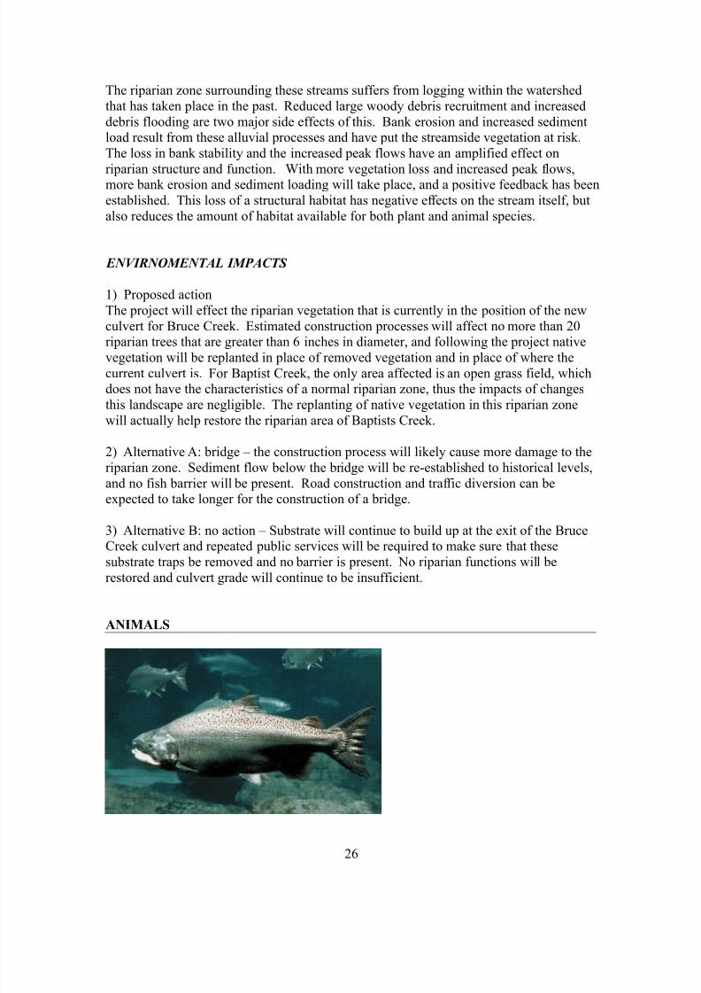
ANIMALS
26

8/14/2019 MtBaker Culvert EIA W08
http://slidepdf.com/reader/full/mtbaker-culvert-eia-w08 27/40
Unique Species: Salmonids
All five species of Pacific salmon including Chinook (Oncorhynchus tshawytscha), coho
(O. kisutch), sockeye (O. nerka), pink (O. gorbuscha), and chum (O. keta) are known to
occur on the North Fork of the Nooksack River. In addition cutthroat trout (O. clarki),steelhead and resident rainbow trout (O. mykiss), and bull trout (Salvelinus confluentus)
are found on the North Fork and the tributary streams in the area (WSR 2003). Of these,
the Chinook, steelhead, and bull trout are listed as threatened species. All of the aboveare salmonid species that are either exclusively anadromous or may have anadromous
forms. These fish complete their life cycles by migrating from the saltwater environment
into the Nooksack watershed in order to lay eggs. Small tributary streams are often used
as spawning grounds by fish returning to spawn. In addition to providing an area for developing eggs, tributary streams serve as important habitat for juvenile fish. They are
often used as refuges to escape from fast-moving water in the main channel during times
of high flow. Tributary streams are also nurseries for growing salmonids, providing
shelter and food for young fish that may not be able to withstand the downstreamenvironment. Aside from concerns regarding the movements of migratory salmon, non-
anadromous fish such as resident rainbow, bull, and cutthroat trout display patterns of movement within a given watershed (Gresswell and Hendricks 2007). When considering
their life-history, it is clear that unrestricted access to all reaches of a given stream is
important for these species.
Listed Species
Chinook salmon (Oncoryhnchus tshawytscha)
On March 24, 1999 Puget Sound Chinook were listed as a threatened species under the
endangered species act. The designated critical habitat listed for Chinook salmon does
not include Bruce or Baptist Creek although the North Fork of the Nooksack is listed. Neither of the creeks provide suitable spawning habitat and although the creeks may be
used by juvenile Chinook salmon this would occur during the high flows of winter and
not during the time of construction (WSDOT 2007).
Steelhead (Oncoryhnchus mykiss)
The Puget Sound steelhead was listed as a threatened species on May 7, 2007. Criticalhabitat for the species is still being developed at this time. Bruce and Baptist creeks
provide potential habitat for the species and it is presumed that the streams were used in
the past (WSR 2003). The creeks would not be used as spawning habitat in their currentstate and it would be very unlikely that steelhead would be present during the
construction phase.
Bull Trout (Salvelinus confluentus)
Puget Sound bull trout received a threatened species listing on November 1, 1999.
Critical habitat for the species does not include Bruce or Baptist creek (USFWS 2005).
Presently, neither creek would provide adequate spawning habitat for bull trout nor it
27

8/14/2019 MtBaker Culvert EIA W08
http://slidepdf.com/reader/full/mtbaker-culvert-eia-w08 28/40
would be likely that juvenile or adult trout would use the area during the time of
construction.
Gray wolf (Canis lupis)
Gray wolves were listed as endangered in the lower 48 states on March 11, 1967.
Although they are assumed to be very few in number, wolves are present in Washington.Confirmed sightings nearest to the project area include wolves in Ross Lake National
Recreation Area and other isolated regions of the North Cascades (NPS 2004). Wolves
prefer remote areas away from major roads and human activity so it is extremely unlikelythat they would be in the area. Furthermore wolves are generally stationary during the
summer months when construction will be taking place, decreasing the likelihood that
wolves might be migrating through the area.
Grizzly bear (Ursus arctos)
Grizzly bears are listed as threatened in the lower 48 states as of July 28, 1975. Grizzly
bears possibly present near the area may include individuals from the North Cascades
Recovery Zone, a small population in north central Washington assumed to consist of lessthan 20 animals (USFWS 2007). Wild grizzlies are very sensitive to human activities and
would likely be present only in the most remote regions within the North Cascades.Grizzly bears also readily avoid roads and would be very unlikely to venture within the
vicinity of Highway 542.
Marbled murrelet (Brachyramphus marmoratus marmoratus)
The marbled murrelet was listed as a threatened species on October 1, 1992. Critical
habitat for the species was later assigned in 1996 with the closest habitat being about five
miles from the project site. The birds prefer more mature forests with large coniferoustrees as habitat. The land surrounding the project area has been logged relatively recently
and the present forest would be unlikely to provide habitat for the species.
Spotted owl (Strix occidentalis)
On June 26, 1990 the spotted owl was listed as threatened. Critical habitat for the species
was designated on January 15, 1992 and the closest such habitat is five miles from thesite. Like the marbled murrelet, spotted owls need mature forests and the previously
logged land surrounding the proposed construction site is not suitable for the species.
ENVIRNOMENTAL IMPACTS
For the listed bird and mammal species, the proposed project and the alternatives pose no
significant effects on these animals. The habitat within the project area does not include
any habitat suitable for the listed species. Other terrestrial species that may be presentwill not likely be displaced or disturbed by any of the construction activities at the site.
State route 542 is a well-used highway and most animals would avoid the area in the first
place.
1) Proposed Action
A properly designed culvert can preserve some of the functions of a creek important for
fish. When maintained and functioning properly, a culvert need not be a detriment to fish
28
8/14/2019 MtBaker Culvert EIA W08
http://slidepdf.com/reader/full/mtbaker-culvert-eia-w08 29/40
species. The culvert can be placed in such a way that the downstream end is not perched
above the creek. Providing adequate water depth through the structure is important in
allowing fish to pass through. Installing a culvert in such a way that water velocities arenot too high will also aid in fish passage. The Washington Department of Fish and
Wildlife has outlined culvert designs with criteria for proper fish passage (WDFW 2003).
A new culvert adhering to these regulations would make the culvert replacementalternative a cost-effective and viable solution with regards to wildlife.
Construction activities proposed by the Department of Transportation may have someeffects on salmonid species. Bruce Creek is seasonal and at the time of construction it
will most likely be dry and there will be no fish present. Similarly Baptist Creek will be
experiencing low flows and the chances that salmonids would be present during the
construction phase are slim. Consequently, the activities at the time of construction arenot likely to disturb salmon or trout species that may use the habitat during specific times
of the year. There is the potential that culvert replacement and stream realignment would
temporarily add sediment to the streams which could diminish water quality for fish
further downstream in the Nooksack River. This is being mitigated by limiting theconstruction activities to the low flow season and by using best management practices
during construction such as erosion control and regulation of certain equipment types toreduce the sediment entering the streambed (Maria Mayrhofer, WSDOT, pers. comm.
2008).
2) Alternative A: BridgeIn terms of fish and other aquatic species, the bridge alternative would be the most
favored. A bridge would allow unrestricted access between the downstream and
upstream creek sections separated by Highway 542. With a bridge there would be astream bank performing important riparian functions. Large woody debris recruitment
could continue, vegetation could grow and stabilize the bank, and the creeks would
generally exhibit more habitat complexity. These characteristics are indicative of ahealthy stream ecosystem and ideal fish habitat.
3) Alternative B: No actionConventional culverts present problems for fish. They are often times impassable for
certain species and restrict their spatial distribution. This can lead to genetic isolation or
eliminate fish from otherwise suitable habitat. Currently the Bruce Creek culvert is
impassable for fish and the Baptist Creek culvert is only partially passable for fish (MariaMayrhofer, WSDOT, pers. comm. 2008). The habitat upstream of the culverts has the
potential to be utilized by fish, especially if stream restoration work is done to improve
the riparian zone. A no action alternative would continue to negatively impact fish populations on both streams.
vi) ENVIRONMENTAL HEALTH
Hazards
The risk for an environmental incident is always present during construction work, but
the standard construction practices and safety measures will be used to minimize the risk
29

8/14/2019 MtBaker Culvert EIA W08
http://slidepdf.com/reader/full/mtbaker-culvert-eia-w08 30/40
of anything happening. As far as emergency services, it will be the responsibility of the
construction contractor. The contractor could require the assistance of the Washington
Department of Ecology, Fish and Wildlife, or other agencies depending upon the severityof a spill, the risk to people, and the environment. In order to reduce hazards the
contractor will be required to prepare an emergency Spill Prevention, Control and
Countermeasures Plan (SPCC). Standard construction practices, safety measures, andtraffic control measures will be required of the contractor to minimize the risk of an
incident. Discovered potentially hazardous waste will be handled in accordance with
Environmental Protection Agency, Department of Ecology, and local health regulations.
Noise
There is currently no noise in the area that might affect the project. Due to the nature of
the project, construction will take place which might temporarily increase due toequipment and construction activities during regular daytime hours. Though on
completion, noise will return to pre-project levels. In order to reduce noise, the
contractor will be required to adhere to all federal, state and local noise regulations
governing construction activities.
ENVIRNOMENTAL IMPACTS
1) Proposed action
The proposed action would create the usual potential construction hazards to
environmental health, but no unnecessary risks would be taken. The noise levels may behigh during daytime hours, which could potentially disrupt the surrounding habitats
throughout the construction. However, the construction would only take place along an
existing highway where noise is already prevalent, so the environment may not be altereddramatically by the increase in noise.
2) Alternative A: bridgeIf the alternative of a bridge occurred, the usual potential construction hazards to
environmental health, but no unnecessary risks would be taken. The noise levels may be
high during daytime hours, which could potentially disrupt the surrounding habitatsthroughout the construction. However, the construction would only take place along an
existing highway where noise is already prevalent, so the environment may not be altered
dramatically by the increase in noise.
3) Alternative B: no action
If no action were to be taken, the environmental health would not be put at risk. As well,
noise levels would not be raised, which would leave the existing environment at it currentlevel.
30

8/14/2019 MtBaker Culvert EIA W08
http://slidepdf.com/reader/full/mtbaker-culvert-eia-w08 31/40
B. Built Environment
i) AESTHETICS
a) Aesthetics
The invasive nature of road construction would cause for a removal of natural vegetationwhich is aesthetically displeasing to passersby. Because culvert replacements take place
beneath the existing roadway there are usually minimal effects to the aesthetics of the
area. Passing traffic while be affected only temporarily while vegetation re-grows andconstruction is taking place. Because there are no residents in the general vicinity, there
is less chance of affecting a large number of people.
b) Light and Glare
Aesthetically displeasing effects from light and glare caused by this project would only
be temporary during the time of construction. Construction is usually done during the
daytime to reduce effects on nearby habitats and therefore is not a problem for civiliansusing the roadway.
c) Historical and Cultural PreservationCultural resource surveys conducted by the Department of Transportation did not indicate
any areas for preservation in the area. The work is being done on a scenic highway
through rural forested area so there are not many, if any surrounding historic
establishments. Baptist Creek runs through the former Baptist Bible Camp, a historic siteof the Conservation Corps Camp, which sits on milepost 28.3.
ENVIRNOMENTAL IMPACTS
1) Proposed action
The Proposed action would ultimately be an aesthetically pleasing project. As the nativevegetation recovers from construction and stream realignment the area will return to a
31

8/14/2019 MtBaker Culvert EIA W08
http://slidepdf.com/reader/full/mtbaker-culvert-eia-w08 32/40
more natural environment. Larger roadways near the Bruce Creek culvert would instill
an increased sense of security to drivers and bikers along the Mt. Baker Highway. Due to
the lack of detour options, the road will remain open during construction, allowing passing traffic to be visually affected by the work. This displeasing effect would only be
temporary until work crews finish. The culvert replacement will not affect the integrity
of the former Baptist Bible camp as construction will focus solely on the culvert beneaththe highway.
2) Alternative A: bridgeBuilding a bridge for the streams to flow under would increase construction time greatly.
The construction practices would be more invasive to the surrounding area and would
take longer to complete, therefore the surrounding community and those that utilize Mt.
Baker Highway would be affected by the presence for an extended period of time.Building a bridge would also require the removal of more vegetation which could cause a
negative aesthetic impact.
3) Alternative B: no actionThose that utilize Mt. Baker Highway would not be affected by any large project during
its time of construction and would not have to view and area returning to a more naturalenvironment. However, not replacing the culverts would require continued presence of
construction to dredge out the build-up of sediment.
ii) PUBLIC SERVICES AND UTILITIES
The public services and utilities around the project are minimal; the culvert replacementsonly address issues to travel along SR 542. The projects are presumed to only last 45
days, and traffic will be one lane at the time of construction. SR 542 is the only route toaccess two major recreational sites: the Snoqualmie-Mt. Baker national forest and the Mt.Baker ski area. Travel at the time of construction will be restricted and patrons utilizing
these areas should expect delays. There is a Baptist camp which owns land functions as
the riparian zone to tributaries of Baptist Creek. Part of the construction will be done on
the private property of the Baptist camp. Maintenance crews are required to repeatedlydredge out substrate build up blocking off the outflow from the current culvert for Bruce
Creek.
ENVIRNOMENTAL IMPACTS
1) Proposed ActionThis will affect the travel of police, fire trucks, and persons using the road to access
recreational destinations such as the Mt. Baker ski area and the Mt. Baker-Snoqualmie
National Forest. The maintenance required to remove sediment build at the exit of the
current Bruce Creek will no longer be an issue. The new culvert will allow for muchmore sediment to pass without building up because of an increased slope on the new
culvert.
32

8/14/2019 MtBaker Culvert EIA W08
http://slidepdf.com/reader/full/mtbaker-culvert-eia-w08 33/40
2) Alternative A: bridge
The amount of time required for a bridge construction is greater. Access for Police,
Firemen, and persons using the recreational facilities will be more difficult if notrestricted for bridge construction. The maintenance required on the Bruce Creek culvert
will be alleviated and the natural stream bed characteristics will be restored.
3) Alternative B: no action
No change in the public services will take place if no action is taken. Maintenance crews
will still be required to repeatedly dredge out the build up on the outflow from the BruceCreek culvert.
iii) TRANSPORTATION
SR 542, also known as the Mount Baker Scenic Byway, is the only route serving the
project area, and there is no public transit out to the site. This byway is a relatively short57 miles, but the attractions and scenery found along the Mount Baker Highway are
numerous. Mount Baker Highway begins just west of Bellingham and winds up to
spectacular Artist Point, the end of the highway. The highway is home to whatever visitors are searching for from solitude and beauty, to fun and recreation, to the dazzling
experience of all that Mount Baker has to offer. Unlike many byways, this road does not
lead to another location or area.
ENVIRNOMENTAL IMPACTS
1) Proposed Action
If the proposed action occurs the SR 542 road section within the Bruce Creek projectlimits will be realigned as described in the project description. The project claims that itwill not generate additional traffic to the area, but since there is no public transit, and
construction workers will need to arrive on the job, some additional traffic should be
expected. Along with that, there is no parking along the highway, so the contractor will
have to find locations along the road that do not interfere with the surroundingenvironment. A traffic control plan would be implemented to minimize disruptions to
traffic during construction activities.
2) Alternative A: bridge
If bridges are built instead of new culverts then it too will create additional traffic with
construction workers and machinery. Along with that, there is no parking along thehighway, so the contractor will have to find locations along the road that do not interfere
with the surrounding environment. A traffic control plan would be implemented to
minimize disruptions to traffic during construction activities.
3) Alternative B: no action
If no action occurs, then transportation will not be affected.
33

8/14/2019 MtBaker Culvert EIA W08
http://slidepdf.com/reader/full/mtbaker-culvert-eia-w08 34/40
List of Technical Terms
Aesthetics The theory and perception of beauty on an individual level
Alluvium Sediment deposited by rivers or streams around the riparian zone
Anadromous In terms of fish, these are species which migrate from the sea to freshwater streams to spawn
Aquifer Subterranean layer of earth yielding groundwater
Barrier A physical structure which prevents the migration of salmon species
Chronic Environmental
Deficiencies
According to the WS Department of Transportation, these are the areas alongthe state's highway system which cause impact to fish habitat
Coniferous Forest Cone-bearing trees, commonly referred to as 'Evergreen' trees
Culvert A means of transporting water beneath a roadway system. These havehistorically been constructed using steel tubing and have been the subject of many stream restoration projects
Ecosystem The biotic and abiotic factors of a specific area and their relationships witheach other
Endangered Species
Act
US environmental law to protect threatened and endangered species beforethey are subject to extinction
Erosion The degradation of the land surface by natural or anthropogenic forces
Fauna Animal life which is characteristic to a particular area
Fine Fraction In terms of soil particles, the fine fraction are composed of clays and silts.These particles are less than 2mm in size
Floodplain region of land adjacent to a river or stream that is periodically inundated withwater during flood events
Flora Characteristic plant life of a particular area
Gradient A graded change in a particular unit of measure
Impervious surfaces Ground cover which prevents the infiltration of water. These surfaces are
generally characterized by paved roads made of concrete, asphalt, stone, or bricks
Instream Pertaining to an area within the stream channel
Interstitial pores Void spaces between soil particles which commonly hold soil air or water
Large woody debris Also known as 'course woody debris'. Large piece of tree which has adiameter greater or equal to 10 cm. These pieces protrude into streams andincrease stream habitat complexity
34

8/14/2019 MtBaker Culvert EIA W08
http://slidepdf.com/reader/full/mtbaker-culvert-eia-w08 35/40
Loam A soil texture which is characterized by an equal amount of sands, silts andclays
Loess Commonly silt-sized soil particles transported and deposited through winderosion
Mass wasting Erosional movement of the landscape down a slope through the force of gravity
Permeability The measure of interconnectedness of pores, and the ease of water and air movement through the soil
Porosity The volume of void spaces within the soil
Riparian zone The zone of interaction between terrestrial and aquatic ecosystems typicallycharacterized by rivers or streams
Salmonid fish of the salmonidae family including salmon, trout, char, and whitefishes
Sedimentation An accumulation of fine particulate matter in streams which degrade salmonspawning habitat
Tributary Any water body which flows into a larger stream or body of water
Water Capacity The amount of water which can be held within the soil
Water quality Physical, biological and chemical properties of a water system in relation to aset of predefined parameter limits
Watershed The specific area that drains water into a river system framed by anelevational border
35
8/14/2019 MtBaker Culvert EIA W08
http://slidepdf.com/reader/full/mtbaker-culvert-eia-w08 36/40
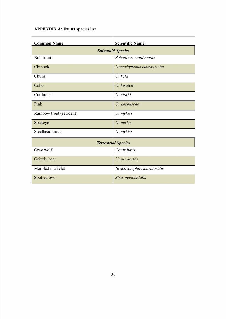
APPENDIX A: Fauna species list
Common Name Scientific Name
Salmonid Species
Bull trout Salvelinus confluentus
Chinook Oncorhynchus tshawytscha
Chum O. keta
Coho O. kisutch
Cutthroat O. clarki
Pink O. gorbuscha
Rainbow trout (resident) O. mykiss
Sockeye O. nerka
Steelhead trout O. mykiss
Terrestrial Species
Gray wolf Canis lupis
Grizzly bear Ursus arctos
Marbled murrelet Brachyamphus marmoratus
Spotted owl Strix occidentalis
36

8/14/2019 MtBaker Culvert EIA W08
http://slidepdf.com/reader/full/mtbaker-culvert-eia-w08 37/40
APPENDIX B: Flora species list
Common Name Species Name
Dominant Tree Species
Big Leaf Maple Acer macrophyllum
Black cottonwood Populus balsamifera
Douglas fir Pseudotsuga menziesii
Grand fir Abies grandis
Red alder Alnus rubra
Western hemlock Tsuga heterophylla
Western red cedar Thuja plicata
Understory Species
Bracken fern Pteridium aquilinun
Indian plum Oemleria cerasiformis
Salmonberry Rubus spectabilis
Sword fern Polystichum munitum
Thimbleberry Rubus parvifloris
Invasive Species
Himalayan blackberry Rubus armeniacus
Reed canarygrass Phalaris arundinacea
37
8/14/2019 MtBaker Culvert EIA W08
http://slidepdf.com/reader/full/mtbaker-culvert-eia-w08 38/40
References
Best Management Practices for ESA & 4(d) Habitat Protection. March 2004.Washington State Department of Transportation – Maintenance and Operations Division.
Construction Site Erosion and Sediment Control Training Manual. 2005. WS Departmentof Transportation
Easterbrook, D.J. 1973. Environmental Geology of Western Whatcom County, WA.
Department of Geology – Western Washington University
Engineering Division of Salt Lake County.1999. BMP: Rock Check Dams -- Stormwater
Discharge Management from Construction Activities.
Environmental Checklist . June 2007. Washington State Department of Transportation –
Northwest Region.
Gresswell RE and Hendricks SR. January 2007. Population-scale movement of coastal
cutthroat trout in a naturally isolated stream network. Transactions of the AmericanFisheries Society 136 (1): 238-253.
Merril, B.R., Casaday, E. 2001. Best management Practices – Culvert Replacement .
California State Parks – North Coast Redwoods District: Roads Trails and ResourcesMaintenance Section.
National Park Service (NPS). March 30, 2004. Wolves in the North Cascades:
Questions and Answers. http://www.nps.gov/archive/noca/wolf.htm. (2/29/08).
Schaetzle, R., Anderson, S. 2005. Soils: Genesis and Geomorphology. CambridgeUniversity Press. New York.
Ruhl, S., Overmoyer, J., Barker, D., Brown, L.C. AEX-304-97. Using Geotextile Fabric
in Livestock Operations. Ohio State University Fact Sheet: Food, Agricultural and
Biological Engineering. Accessed March 8, 2008 from http://ohioline.osu.edu/aex-
fact/0304.html
Schuster, J.E. 2005. Geologic Map of Washington State. Washington State Department of
Natural Resources. Washington Division of Geology and Earth Resources. Map accessed
March 8, 2008 from http://ngmdb.usgs.gov/Info/dmt/docs/schuster07b.pdf
Soil Survey of Whatcom County Area, Washington. 1992. US Department of Agriculture –
Soil Conservation Service.
United States Fish and Wildlife Service (USFWS). September 26, 2005. Endangered and Threatened Wildlife and Plants; Designation of Critical Habitat for the Bull Trout;
Final Rule.
38

8/14/2019 MtBaker Culvert EIA W08
http://slidepdf.com/reader/full/mtbaker-culvert-eia-w08 39/40
http://www.fws.gov/pacific/bulltrout/final/pdf/Bull%20Trout%20CH%20FR%20notice.p
df. (2/27/08).
United States Fish and Wildlife Service (USFWS). 2007. Grizzly Bear Recovery.
http://www.fws.gov/mountain-prairie/species/mammals/grizzly/index.htm. (2/29/08).
United States Geological Survey (USGS). January 5, 2006. Whatcom County Project
Page. http://wa.water.usgs.gov/projects/whatcom/index.htm. (2/20/08).
Washington Department of Fish and Wildlife (WDFW). 2003. Design of Road Culverts
for Fish Passage. http://wdfw.wa.gov/hab/engineer/cm/culvert_manual_final.pdf.
(3/1/08).
Washington State Department of Transportation (WSDOT). March 2007. Biological
Assessment: SR 542 Bruce Creek culvert replacement and realignment, and Baptist Creek culvert replacement and realignment. (Prepared by: Northwest Region Environmental
Services Biology Program) WIN# A54230C
Washington State Department of Transportation (WSDOT). 2008a. Environment- Fish
Passage: Fish Passage Facts.
http://wsdot.wa.gov/Environment/Biology/FP/fishpassagefacts.htm. (3/4/08).
Washington State Department of Transportation (WSDOT). 2008b. Environment- Fish
Passage: Chronic Environmental Deficiences.
http://wsdot.wa.gov/Environment/Biology/FP/CEDretrofits.htm. (3/4/08).
Whatcom County Planning and Development Services (WCPDS). February 25, 2008.
Whatcom County- Title 20 Zoning Designations.
http://www.co.whatcom.wa.us/pds/pdf/planning/gis/t20zon8.pdf. (2/21/08).
Whatcom County Planning and Development Services (WCPDS). September 2005.Whatcom Critical Areas Ordinance- Critical Aquifer Recharge Areas.
http://www.co.whatcom.wa.us/pds/planning/CAO_September/CAO_CARA.pdf.
(2/20/08).
Whatcom Salmon Recovery (WSR). 2003. Maps: Fish Presence.http://www.whatcomsalmon.wsu.edu/maps-fishpresence.html. (2/23/08).
References for Figures, Tables
Figure 1, and Table 1 (erosion mitigation)
Washington State Department of Transportation (WSDOT). 2005. Construction Site
Erosion and Sediment Control Training Manual.
References for Photos
39
8/14/2019 MtBaker Culvert EIA W08
http://slidepdf.com/reader/full/mtbaker-culvert-eia-w08 40/40
Page 1: WSDOT Projects: SR 542, Wells Creek Road to Mount Baker Vicinity – Photos.
http://www.wsdot.wa.gov/Projects/SR542/WellsCreek_MtBaker/photos.htm
Page 13: Erin Smart
Page 20: http://www.photoseek.com/flora.html
Page 25: http://en.wikipedia.org/wiki/Image:Pseudotsuga_menziesii_28236.JPG#file
And http://en.wikipedia.org/wiki/Salmonberry
Page 26: http://wildernessclassroom.com/superior/2006/09/20/
Page 31: WSDOT Projects: SR 542, Wells Creek Road to Mount Baker Vicinity –
Photos. http://www.wsdot.wa.gov/Projects/SR542/WellsCreek_MtBaker/photos.htm