mt read volcanics contents styles of ore deposits/a8246a77.pdf · mt read volcanics contents ......
TRANSCRIPT

i
Mt Read Volcanics
CONTENTS
Age and tectonic/structural setting
Volcanic Architecture
Styles of ore deposits
Exhalites
Alteration facies
Hydrothermal geochemistry
Source of fluids, sulfur and metals
Subvolcanic intrustions
Hydrogeological modelling
Exploration criteria
Research strengths for your VMS district
List of twelve key references

77
Mount Read Volcanics, TasmaniaGlobal comparison of massive sulfides
GEODE
Team:Ron Berry*Tony Crawford*Garry Davidson*Bruce Gemmell*Cathryn Gifkins*Walter Herrmann*Ross Large*Andrew McNeill#Jocelyn McPhie*Mike Solomon*Jianwen Yang*Khin Zaw** University of Tasmania# Pasminco Exploration
4.1 Age and tectonic/structural setting
4.1.1 What is the age of your VMS district?• Extent, type and precision of geochronolgy? (belt scale and deposit scale)• Palaeontological control
Zircon dating of syn-mineralisation volcanics was reported by Perkins and Walshe (1993) and Black et al(1997). The Perkins and Walshe data are based on standard SL13 and should be adjusted up by 1.3% tomatch the later data, which was relative to the QGNG standard. Stratigraphically, footwall rocks have anaverage age of 503 Ma and hanging wall rocks have an average age of 506 Ma. Measurement error formost samples is ~ 7 Ma, so the fact that the footwall rocks appear younger than hanging wall rocks is notsignificant. At the precision of SHRIMP dating these ages are identical.
Palaeontological control on ages is summarised by Laurie et al. (1995). In all cases the VHMS deposits(excluding Henty) are overlain by Middle Cambrian rocks. Que and Hellyer are overlain by the Que RiverShale, with an Floran (504-505 Ma on the AGSO time scale) to Undillan fauna. Mt Lyell is overlain byTyndall Group with a Undillan fauna. Rosebery and Hercules are more difficult, but stratigraphic correlationsplace them substantially lower than Idamean (Late Cambrian) strata and probably below Boomerangian(late Middle Cambrian. There is no fossil evidence for the maximum age of these deposits but in mostcases the fossils are from just above the deposits and should be close to the actual age. The Henty Depositis in the Tyndall Group, which is late Middle Cambrian in age (Undillan and Boomerangian).
The time scale developed by AGSO as reported in Laurie et al 1995, suggests Floran is 504-505 Ma andthus the zircon SHRIMP dates are consistent with mineralisation occurring in a short period in the MiddleCambrian.
Black, L.P., Seymour, D.B., Corbett, K.D., Cox, S.E., Streit, J.E., Bottrill, R.S., Calver, C.R., Everard, J.L.,Green, G.R., McClenaghan, M.P., Pemberton, J., Taheri, J., Turner, N.J., Dating Tasmania’s oldestgeological events, AGSO Record 1997/15 (1997) 57pp.
Perkins, C., Walshe, J.L., Geochronology of the Mount Read Volcanics, Tasmania, Australia, Econ. Geol. 88(1993) 1176-1197.
Laurie JR, Jago JB and Bao J-S, 1995. Review of Cambrian biostratigraphy. AGSO Record 1995/69

78
Fig 1.1: Location of major deposits in the Mt Read Volcanics, Tasmania.
4.1.2 What is the current interpretation of the tectonic setting of your VMS district? (include
Table 1.1: Dates for MRV Volcanics.
Reference Original Adjusted
PandW 1993 Mount Black Dacite 495 9 501 ?footwall Rosebery
Black et al 1997 Bond Range Porphyry 505 7 ?Footwall Hellyer
Black et al 1997 Mt Jukes Lava 503 7 Footwall Mt Lyell
Average 503
PandW 1993 Comstock Tuff 495 8 501 Hanging wall Mt Lyell
PandW 1993 Tyndall Group
Volcaniclastics
503 7 509 Hanging wall Mt lyell
PandW 1993 Anthony Road Andesite 502 7 509 Hanging wall Mt lyell
PandW 1993 Mt Charter Group 503 8 510 Hanging wall Hellyer
Black et al 1997 Winterbrook Lava 500 7 ?post mineralisation
stage
Black et al 1997 Tyndall Ignimbrite 506 4 Hanging wall
Hellyer/Que River
Average 506

79
a time-sequence diagram if available.)
A tectonic model for the setting of Mt Read Volcanics (MRV) magmatism was presented by Crawford andBerry (1992). A 2-stage cartoon showing the stages of development of western Tasmania from 600Ma to500Ma (Fig. 1) is based on the Crawford and Berry model, and shows the MRV as a post-collisional suite,being erupted in half-graben developed in recently assembled crustal collage of an arc-continent collisionzone. A 600Ma-old east-facing volcanic passive margin, represented by the Rocky Cape block of NWTasmania, collided with the forearc section of a west-facing intra-oceanic arc probably about 510Ma. Thisresulted in west-directed emplacement of large, forearc-derived allochtonous sheets of boninite-dominatedophiolitic rocks and some parautochthonous basement slices, onto the passive margin. The latter musthave been very attenuated crust, like the leading edge of many modern passive margins, as post-collisionalmagmatism was largely submarine, implying that large collision-related mountain ranges were not producedin this rather ‘passive’ collision.
In the latter stages of collision exhumation of some of the underthrust (sub-ophiolite) passive margincrystalline crust imposed a structural control on the appearance of post-collisional magmatism, restrictingMRV largely to half graben west of the actively exhuming crystalline crust that eventually formed the Tyennannucleus of Tasmania. There is no compelling evidence that the MRV are associated contemporaneoussubduction. However, major crustal extension is recorded in the progression of magma types throughoutthe life of the MRV, with a late change from primitive shoshonitic basalts to tholeiites (most as dykes).Cessation of extension is recorded by the sudden demise of mafic magmatism, and the felsic ‘flare-up’ atthe end of MRV magmatism, coupled with the sudden appearance of extensive black shales above themafic volcanics.

80
Fig 1.2: Schematic Late Proterozioc-Cambrian tectonic evolution of Western Tasmaniafrom Crawford and Berry (1992)
4.1.3 What is the tectonic interpretation based upon:• structural mapping and interpretation? (quality of mapping?)

81
• gravity and/or magnetic data (has it been used?)• any seismic sections ?• chemistry of volcanic rocks? What geochemical-tectonic classification was used?
The Crawford and Berry (1992) model and interetation of the MRV as a post-collisional suite was deducedin large part from lithostratigraphic information provided by regional mapping and structural studies, andpetrological-geochemical evidence.
The whole of the Mt Read Volcanics has been mapped at 1:25,000. Near mineralisation, 1:5000 maps areavailable. The level of vegetation cover and paucity of outcrop means that these maps are not as good asmight otherwise be expected, but they represent a major resource and more lithological mapping can onlybe attempted where drillcore support is available.
Structural data is available on these maps. More structural data has been obtained and a structuralinterpretation produced along a number of sections (Berry 1999 and unpublished). The structure is dominatedby Devonian folding and thrusting so that the Cambrian structure is very poorly known except in a few localareasGravity is dominated by Devonian granites and has not been useful in determining the structural controlson mineralisation. Magnetics has been affected by a number of processes but has been used to recognisedsome Cambrian intrusives
A high resolution seismic section was attempted across parts of the region but the lack straight roads,complex geology (with steep dips and complex variations in layering has hampered interpretation of thisdata. At present the only public interpretations are to simple to be any help in structural interpretation. Thedeep seismic sections have no resolution in the top few km and have not been integrated with the surfacegeology.
A very large database of high quality analyses of MRV (see below) has enabled thorough studies of thegeochemical affinities of the lava suites constituting the MRV (Crawford et al., 1992). Medium- and high-Kcalc-alkaline and shoshonitic lavas are best represented, based on detailed trace element data includingREE patterns and comparisons with modern suites.
4.1.4 Is there a comprehensive and high quality database of volcanic geochemistry toassist with tectonic interpretation?
• how many whole-rock/trace analyses on least-altered rocks?• type and quality of trace element data?• what isotope data are available?
More than 500 wholerock major and trace element analyses are available, including data for all recognisedmagmatic suites within the MRV. Data available before 1992 are summarised by Crawford et al., (1992),and considerably more data has derived from several AMIRA projects, for which confidentiality restrictionshave expired. Approximately half of these analyses are of rocks in which alteration is either insignificant, orunlikely to have affected useful geochemical discriminators. All analyses are by XRF for major elementsand about 13 trace elements (Rb, Ba, Sr, Ni, Cr, V, Sc, Zr, Nb, Y, Cu, Pb, Zn). About one quarter of theseanalyses are complemented by more detailed trace element data, including for most of these REE, Th, U,Hf , (and more precise Nb data) by ICP-MS. Presently, about 15 Nd-Sr isotope analyses are availableacross the range of lithostratigraphic units represented in the MRV. Work in progress (P. Hollings, T. Crawford)is focussing on the felsic rocks within the MRV, to determine approximately what proportion of these arecrustal melts, and how much are the products of extensive AFC from more mafic parental magmas. Otherstudies in progress (G Davidson, W Herrmann) are assembling further Sr-Nd isotopic data to elucidatealteration pathways and budgets. A small unpublished database of Pb isotopic data for the Hellyer basaltsand associated rocks also exists.
Crawford, A. J., Corbett K.D., and Everard, J., 1992. Geochemistry and tectonic setting of a CambrianVMS-rich volcanic belt: the Mount Read Volcanics, W Tasmania. Economic Geologyy, v.87,p.597-619.Crawford, A.J. and Berry R.F., 1992, Tectonic implications of Late Proterozoic - early Palaeozoic igneousrock associations in W Tasmania. Tectonophysics 214, p.37-56.
4.1.5 Have the district-scale and deposit-scale ore-fluid plumbing structures beenidentified? Size of structures? How were they defined (mapping?, alteration?,

82
aeromagnetics? geochemistry? Isotopes?)
No. See also 9.3.
4.1.6 Have detailed structural studies of the deposits been undertaken? Which deposits?
HellyerThe Devonian and Cambrian structural environment well defined.Downs, R.C., 1993, Syn-depositional fault controls on the Hellyer volcanic-hosted massive sulphide deposit.
(M Econ Geol Thesis, University of Tasmania, Unpubl.)
Que RiverThe Devonian structure relatively well known. No serious attempt to understand the Cambrian structuralcontrols on mineralisationLarge, R.R, McGoldrick, P.J., Berry, R.F. and Young C.H., 1988. A tightly-folded, gold-rich massive sulfide
deposit: Que River Mine, Tasmania. Economic Geology. V.83, p.681-693.
RoseberyA very extensive literature. The Devonian structure is well described. The intense Devonian faulting makes
resolving Cambrian structure difficult but some attempts have been made (Berry and Keele 1997 andR Allen unpublished reports.)
Aerden, D.G.A.M., 1991, Foliation-boudinage control on the formation of the Rosebery Pb-Zn orebody,Tasmania. J Struct. Geol. 13, p.759-775.
Brathwaite, R.L., 1974, The geology and origin of the Rosebery ore deposit. Economic Geology v.69,p.1086-1111.
Berry, R.F., 1991, Structure of the Rosebery Deposit. Structure and mineralisation of western Tasmania.CODES: AMIRA project P291, Report No. 3, November 1991: 1–21.
Berry, R.F., 1992, Geochemical evidence for the structure of the Rosebery deposit. Structure andmineralisation of western Tasmania. CODES: AMIRA Project P.291 report 4. University of Tasmania:51–66.
Berry, R.F., and Keele, R.A., 1997, Cambrian tectonics and mineralisation in Western Tasmania. AusIMM3rd International Mining Conference, November 1997, p13-16.
HerculesA few general papers showing the late structural history of the deposit. Lots of unpublished data on thegeometry and genesis. The interpretation of this relatively inaccessible data remains to be done.
Mt LyellVery extensive literature. The late structure and mapping is well constrained. The Cambrian geometry andcontrols on mineralisation have been investigated but remain highly contentious.Arnold, G.O., and Carswell, J.T., 1990, The Mt Lyell deposits. In: Geological aspects of the discovery of
some important mineral deposits in Australia. Glasson, K.R., and Rattigan, J.H., (eds.) MonographSeries - Australasian Institute of Mining and Metallurgy. 17; 135-139. 1990.
Cox, S.F., 1981, The stratigraphic and structural setting of the Mt Lyell volcanic-hosted sulfide deposit.Econ. Geol. 76, 231-245.
Solomon, M., 1967, Fossil gossans (?) at Mt Lyell, Tasmania. Econ Geol 53, 757-772.Berry, R.F., 1992. Mount Lyell Mine Leases: Summary. Structure and mineralisation of western Tasmania.
CODES: AMIRA Project P.291 report 4. University of Tasmania: 67–76.
HentyDevonian structure well constrained. Evidence for structural control on mineralisation limited.Halley, S.W., and Roberts, R.H., 1997, Henty; a shallow-water gold-rich volcanogenic massive sulfide depositin western Tasmania. Economic Geology v.92, p.438-447.
4.1.7 What further research is needed to improve the tectonic interpretation?
One major consideration that would improve our understanding of many aspects of the Mt Read Volcanicswould be the availability of a geochronological technique that could date rocks with a relative error of ±

83
1m.y., rather than the 5 m.y. error currently given on SHRIMP zircon dates. No suitable technique is currentlyavailable to match this precision.
We do not know what underlies the main section (Central Volcanic Complex) of the Mt Read Volcanicsalong the length of the belt. To test this, one or more drill holes in excess of 3km depth would be required.Deep seismic reflection presently available does not provide adequate resolution at shallow crustal levels(<5km) to answer questions relating to the basement of the Mt Read Volcanics.
Finally, whereas detailed structural and volcanological data are available for near-mine sequences, a morebelt-wide synthesis of the structural and volcanological data, together with ‘filling-in’ of obvious gaps alongthe belt, would certainly contribute to an enhanced understanding of the tectonic setting of this importantbelt.
4.1.8 List key references
See above.
4.2. Volcanic architecture
4.2.1 What are the scales of geological maps available for the district and the deposits?Has a comprehensive systematic stratigraphy been established for the district?
High quality 1:25,000 regional geological maps were produced by Mineral Resources Tasmania during the1980s, taking advantage of new HEC roads and excavations. These maps cover the central portion of theMRV and surrounding formations, giving information on lithology, stratigraphy, structure, and alteration.These maps also introduced systematic lithostratigraphic terminology for the region. Some of the mapshave accompanying reports in which the geology is described in detail. Unpublished maps of geology andalteration at widely varying but generally larger scales have been produced for the major massive sulfidedeposits and prospects by mining and exploration companies previously and currently active in the area.An additional unpublished geological map resource exists in research theses at the University of Tasmania.
The Mount Read Volcanics have been divided into four regionally mappable lithostratigraphic units thatcomprise a range of volcanic and sedimentary facies (Corbett and Lees, 1987; Corbett, 1992). The principallithostratigraphic units are: the Eastern quartz-phyric sequence, the Central Volcanic Complex, the Westernvolcano-sedimentary sequence (comprising the Dundas Group, Mount Charter Group and Yolande RiverSequence) and the Tyndall Group (Corbett, 1992). There are in addition locally important, separatelynamed volcanic successions that can be distinguished on the basis of lithology and/or composition (e.g.Que-Hellyer Volcanics, Anthony Road Andesite). North-south elongate Cambrian granites (Darwin Granite,Murchison Granite) intrude the succession, mainly along the eastern side. Some ambiguity remains as tothe relative timing of these lithostratigraphic units. Also, although some lithostratigraphic units (eg. TyndallGroup) or parts of units (e.g. Dundas Group, Mount Charter Group) have been formally defined, most havenot.
4.2.2 How do the VMS deposits relate to volcanic facies? Provide some sketch diagramsif available . Do the VMS deposits occur at a single stratigraphic position? Do theVMS deposits occur in proximal or distal volcanic facies? Percentage of volcaniclasticrocks versus coherent flows or intrusions?
The main massive sulfide ore deposits in the Mount Read Volcanics occur in successions composed ofdiverse volcanic and non-volcanic sedimentary rocks (Corbett and Lees, 1987; Corbett, 1992). They arenot restricted to a single stratigraphic unit although the largest (Rosebery and Mount Lyell) occur in theCentral Volcanic Complex (Corbett and Solomon, 1989). Footwall and hangingwall volcanic facies includelavas, syn-volcanic sills, volcaniclastic and sedimentary facies (McPhie and Allen, 1992; Waters and Wallace,1992; Allen and Cas, 1990; Large et al., 2001). The lavas and sills comprise both coherent and autoclastic(autobreccia, hyaloclastite, resedimented hyaloclastite and peperite) facies (McPhie and Allen, 1992). Thevolcaniclastic facies include massive to graded beds of rhyolitic pumice breccia, massive to diffusely stratified

84
crystal-rich sandstone, massive to graded beds of polymictic volcanic conglomerate or breccia, and massiveor laminated shard-rich siltstone (Allen and Cas, 1990; McPhie and Allen, 1992; White and McPhie, 1997;Corbett, 1992; Corbett and Lees, 1987). Sedimentary facies include black pyritic mudstone, and Precambrianbasement-derived micaceous mudstone and lithic sandstone (McPhie and Allen, 1992).
The Hellyer and Que River massive sulfide ore deposits are hosted in the Que-Hellyer Volcanics, animportant interval of mainly andesitic volcanic facies apparently near the base of the Mount Charter Groupin the northern Mount Read Volcanics (Corbett and Komyshan, 1989). The massive sulfides occur above afootwall comprising feldspar-phyric andesitic and basaltic lava and sills, together with associated autoclasticbreccia (mainly hyaloclastite) and peperite (Waters and Wallace 1992) . The hangingwall is dominated bybasalt (Hellyer Basalt). The abundance of basalt-mudstone peperite indicates that most of the basalt unitsare sills that intruded black mudstone (Que River Shale). Very thick, graded units of rhyolitic pumiceousand volcanic lithic breccia interbedded with turbidites and mudstone occur in the upper parts of thehangingwall (Southwell Subgroup). The two ore bodies are quite separate but apparently occur at thesame stratigraphic position. At Hellyer, the ore position is marked by coarse polymictic volcanic breccia,sandstone and mudstone. At Que River, dacitic lavas and domes and dacite-derived volcanic breccia arethe dominant facies at the ore position.
Trilobites in the Que River Shale, very thick sections of black mudstone and the abundance of gradedmass-flow units collectively indicate that the Hellyer massive sulfide formed in a deep (>1000 m?) submarinesetting. The volcanic facies association indicates proximity to intrabasinal vents for effusive, basaltic andandesitic eruptions and syn-volcanic intrusions.
The Rosebery and Hercules massive sulfide lenses occur in part of the Central Volcanic Complex dominatedby very thick, weakly graded units of feldspar-phyric rhyolitic pumice breccia. The ore lenses are located inthe stratified pumiceous sandstone and mudstone top (“host rock”) of very thick pumice breccia that formsmost of the footwall (Allen and Cas, 1990). The hangingwall comprises thick graded beds of variablycrystal-rich and pumiceous sandstone (“hangingwall pyroclastics”) interbedded with black mudstone.
A below-wave-base submarine setting for the Rosebery-Hercules succession is clear from the presence ofvery thick graded beds and black mudstone but there are no features that provide more precise constraints.The volcanic facies association is dominated by syn-eruptive pumiceous mass-flow deposits generated bya voluminous rhyolitic explosive eruption. This area was a major depocentre in proximity to active ventsalthough no vent positions have been identified within the area encompassed by existing exposures.
The Mount Lyell massive sulfide ore bodies also occur in the Central Volcanic Complex (Corbett, 1992;Cox, 1981). However, understanding of the stratigraphic context of these deposits has been inhibited bythe difficulty of facies identification and interpretation in the large areas of intense hydrothermal alteration.The host succession is dominated by massive or locally flow-banded, feldspar-phyric, rhyolitic lavas, domesand intrusions intercalated with thick intervals of feldspar-phyric pumice breccia. The volcanic facies providefew clear constraints on the depositional setting. Very thin intervals of laminated shard-rich mudstone andmixed-provenance mudstone are consistent with a below-wave-base setting. The thick felsic lavas anddomes are probably products of intrabasinal vents and essentially occupying source positions. Thick bedsof pumice breccia could be derived from the similar intrabasinal vents or else, from more remote ventsoutside the existing exposures.
The Henty gold deposit is the Tyndall Group which is the youngest lithostratigraphic unit in the MRV (Corbett,1992). At Henty, the lower part of the Tyndall Group comprises crystal-rich volcanic sandstone, volcanicbreccia, quartz-phyric rhyolitic lava and autoclastic breccia, welded ignimbrite, mudstone and hematiticfossiliferous limestone (White and McPhie, 1996, 1997; Halley and Roberts, 1997). The upper part isdominated by very thickly bedded, polymictic volcanic and mixed-provenance conglomerate and sandstone.The mineralised zone is stratabound and occurs at the base of the Tyndall Group. The immediate hostfacies is an intensely altered assemblage of carbonate, silica, albite and phyllosilicates.
The Tyndall Group differs from other lithostratigraphic units in the MRV in containing evidence for depositionin relatively shallow water (shelf, up to few hundred metres). In particular, it includes limestone with ashallow marine fossil assemblage (Jago et al., 1972) and in situ welded ignimbrite (White and McPhie,1997), and overlies an unconformity surface involving substantial erosion of older MRV lithostratigrsphicunits. The Tyndall Group may also be significantly younger (up to 5 Ma) than the rest of the MRV (Perkinsand Walshe, 1993). At Henty, the volcanic succession includes the proximal products of intrabasinal vents

85
(rhyolite lava and breccia) and also a more distal association of reworked and resedimented volcaniclasticfacies generated by felsic, mainly explosive volcanic centres ignimbrite (White and McPhie, 1996).
In summary, VHMS mineralisation in the Mount Read Volcanics occurs in diverse volcanic facies and bothat seafloor positions (Hellyer and Que River, Gemmell and Large, 1992) and as shallow sub-seafloorreplacement (Rosebery and Hercules, Allen and Hunns, 1990; Khin Zaw and Large, 1992). Rosebery andHercules both occur in a distinctive pumice breccia-dominated facies association at more or less the samestratigraphic position, probably near the top of the Central Volcanic Complex. The hangingwall successionsat Rosebery-Hercules and Hellyer-Que River are very similar, comprising black shale interbedded withquartz-bearing volcaniclastic mass-flow units. Correlation of these two successions would imply that themassive sulfide ore bodies formed approximately contemporaneously, or at least during a fairly narrow timeinterval coinciding with a hiatus in the accumulation of volcanic facies (McPhie and Allen, 1992). Thisspeculation cannot presently be extended to include the Mount Lyell ore bodies as existing stratigraphicconstraints are inadequate. The Henty ore deposit is clearly younger, occurring in the Tyndall Group whichunconformably overlies the Central Volcanic Complex.
4.2.3 What is the composition (rhyolite?, basalt?) of the VMS host package? Is there achange in volcanic composition at, or close to, the ore position?
Geochemical research in the MRV has been biased toward lavas and intrusions, with little attempt tosample and analyse the diverse and voluminous volcaniclastic facies present. Nevertheless, the dataclearly show that medium to high K calc-alkaline rhyolite and dacite are predominant, with locally abundantandesite and basalt (Crawford et al., 1992).
At Hellyer and Que River, the footwall volcanic succession is dominated by andesite and basaltic andesite,with only very minor dacite. Dacitic lavas and lava-derived breccia are important at the level of the orebodies, especially at Que River. The hangingwall comprises black pyritic mudstone intruded by basalticand basaltic andesite sills termed the Hellyer Basalt (Corbett and Komyshan, 1989; Whitford et al., 1989;Waters and Wallace, 1992). The Hellyer Basalt has a distinctive geochemical signature, ranging from highK calc-alkaline to shoshonitic in character (Crawford et al., 1992). Higher parts of the hangingwall successionare rhyolitic, including quartz-phyric pumice breccia and minor lavas.The Rosebery and Hercules ore bodies are hosted by a rhyolitic and dacitic volcanic succession (Corbett,1992). The ore lenses occur in the fine-grained stratified top of a very thick interval of feldspar-phyricpumice breccia (Allen and Cas, 1990). Most of the footwall pumice breccias are rhyolitic (Ti/Zr ~ 6), howeverpumice breccia at the ore position is dacitic (Ti/Zr ~ 11) (Large et al., 2001). Volcaniclastic units in thehangingwall are also rhyolitic but distinctive in being quartz(+feldspar)-phyric (Lees, 1987; Lees et al.,1990).
Most of the Mt Lyell ore bodies occur in strongly altered, rhyolitic to dacitic volcanic rocks of the CentralVolcanic Complex. However the Comstock ore body is hosted in an interval of andesitic lavas and brecciasstratigraphically between the Central Volcanic Complex and the Tyndall Group (Corbett, 1992).
The Henty Gold deposit occurs in part of the Tyndall Group dominated by calc-alkaline rhyolite (Corbett,1992; Crawford et al., 1992). In some places, crystal-rich volcaniclastic sandstone at the base of theTyndall Group (Lynchford Member; White and McPhie, 1996) reflects an andesitic to dacitic provenance.
In summary, in most cases, there is no clear pattern involving a distinct change in geochemistry coincidentwith the massive sulfide ore bodies in the Mount Read Volcanics. A possible exception occurs at Hellyerwhere footwall and hangingwall compositions show the most marked differences.
4.2.4 What is the interpreted range of water depth during deposition of the volcanicsuccession, and immediate host rocks? What criteria were used to estimate waterdepth (eg. volcanic facies, sedimentary structures, fossils, fluid inclusions)?
A below-wave base, submarine environment of deposition is interpreted for most of the lithostratigraphicunits in the Mount Read Volcanics, based on the presence of trilobites and other marine fossils, thicksuccesions of turbidites and black pyritic mudstone in the sedimentary facies association. This interpretationis consistent with the presence of very thick (tens of metres) volcaniclastic mass-flow units, hyaloclastite,

86
peperite and pillow lava in the volcanic facies association. Although neither the sedimentary nor the volcanicfacies associations give precise depth limits, the Central Volcanic Complex, Western Volcano-sedimentarysequence and Eastern quartz-phyric sequence were probably deposited in a relatively deep-waterenvironment (>1000 m?). The occurrence of limestone, shallow marine fossils and welded ignimbrite in theTyndall Group suggests that it was deposited in a shallower water, shelf setting, at or just below storm wavebase (Jago et al., 1972; White and McPhie, 1997). Thus, the Rosebery, Hercules, Hellyer, Que River andMount Lyell ore bodies probably all formed in a deep submarine environment, whereas the Henty golddeposit formed in a shallower submarine environment.
4.2.5 What further research is needed to define the relationship between ore formationand volcanic architecture?
Additional geochronology, preferably U/Pb in zircon dates. The current data are high quality but too few.This is especially critical for the Tyndall Group, recently recognised as prospective for gold-rich mineralisation.
A combination of geochemistry and volcanic facies analysis could clarify and refine correlations among theprincipal lithostratigraphic units. The best facies to target would be large-volume, thick pumiceous mass-flow units that present mapping suggests were originally widespread. Similar units have already beenidentified in parts of the Western Volcano-sedimentary sequences (Southwell Sub-group, Yolande RiverSequence and White Spur Formation) and the Rosebery-Hercules hangingwall. Correlation of thes unitswould greatly advance understanding of the timing of massive sulfide formation.
The massive sulfide deposits of the Mount Lyell field are the least well understood in terms of volcanicfacies context. Strong alteration has discouraged any serious attempt at volcanic facies analysis. However,facies research on surrounding, less strongly altered areas could significantly improve knowledge of thehost succession and enable an extension of facies analysis into the more altered areas.
Stratigraphic relationships among the main lithostratigraphic units are in most cases poorly constrained.Poor exposure, rugged terrain and alteration. Investment in carefully positioned, deep, diamond drill holeswould provide stratigraphic information not otherwise available and of key importance in understanding thegeological framework of the massive sulfide deposits.
4.2.6 List key references*indicates key references
*Allen, R.L. and Cas, R.A.F., 1990. The Rosebery controversy: Distinguishing prospective submarineignimbrite-like units from true subaerial ignimbrites in the Rosebery-Hercules Zn Cu Pb massive sulphidedistrict, Tasmania. 10th Australian Geological Convention. Geological Society of Australia, Abstractsv.25, 31-32.
Allen, R.L. and Hunns, S.R., 1990. Geology of the Hercules and South Hercules Ore Bodies. ExcursionGuide.
Corbett, K.D., 1986. The Geological Setting of Mineralisation in the Mt. Read Volcanics. In R.R. Large (Ed.)“The Mount Read Volcanics and Associated Ore Deposits”. p 1-10.
*Corbett, K.D., 1992. Stratigraphic-volcanic setting of massive sulfide deposits in the Cambrian MountRead Volcanics, Tasmania. Economic Geology, v.87, 564-586.
*Corbett, K.D., and Lees, T.C., 1987. Stratigraphic and structural relationships and evidence for Cambriandeformation at the western margin of the Mt Read Volcanics, Tasmania, Australia. Australian Journalof Earth Science, v.34, 45-67.
Corbett, K.D., and Solomon, M., 1989. Cambrian Mt Read Volcanics and Associated Mineral Deposits. InBurrett, C.F. and Martin, E.L. (eds.) 1989, Geology and Mineral Resources of Tasmania. SpecialPublication Geological Society of Australia 15, 84-153.
Cox, S.F., 1981. The stratigraphic and structural setting of the Mt Lyell volcanic-hosted sulfide deposit.Econ. Geol. 76, 231-245.
*Crawford, A.J., Corbett, K.D. and Everard, J.L., 1992. Geochemistry of the Cambrian volcanic-hostedmassive sulfide-rich Mount Read Volcanics, Tasmania, and some tectonic implications. EconomicGeology, v.87, 597-619.
Gemmell, J.B. and Large, R.R., 1992, Stringer system and alteration zones underlying the Hellyervolcanogenic massive sulfide deposit, Tasmania, Australia: Economic Geology, v.87, no.3. p.620-649.
*Halley, S.W. and Roberts, R.H., Henty: A shallow water, gold rich VMS deposit in Western Tasmania,Economic Geology, v.92, pp.438-447.

87
Jago, J.B., 1977. Late Middle Cambrian fauna from the Que River beds, western Tasmania. Royal Soc.Tasmania Papers Proc., v.111, 41-57.
Jago, J.B. and Brown, A.V., 1989. Middle to Upper Cambrian fossiliferous sedimentary rocks. Geol. Soc.Aust. Spec. Publ. 15, 74-83.
Jago, J.B., Reid, K.O., Quilty, P.G., Green, G.R. and Daily, B., 1972. Fossiliferous Cambrian limestone fromwithin the Mt Read Volcanics, Mt Lyell mine area, Tasmania. Journal of Geological Society of Australia,v.19, 379-382.
Lees, T.C., 1987. Geology and Mineralisation of the Rosebery-Hercules area, Tasmania. Unpublished MastersThesis.
Lees, T., Khin Zaw, Large, R.R. and Huston, D.L., 1990. Rosebery and Hercules Copper-Lead-Zinc Deposits.In Geology of the Mineral Deposits of Australia and Papua New Guinea (Ed. Hughes, F.E.), 1241-1247.
*McPhie, J., and Allen, R.L., 1992. Facies Architecture of Mineralised Submarine Volcanic Sequences:Cambrian Mount Read Volcanics, Western Tasmania. Economic Geology, v.87, 587-596.
Pemberton, J., and Corbett, K.D., 1992. Stratigraphic-facies associations and their relationship tomineralisation in the Mount Read Volcanics. Bull. geol. Surv. Tasm., v.70, 167-176.
*Perkins, C. and Walshe, J.L., 1993. Geochronology of the Mount Read Volcanics, Tasmania, Australia.Economic Geology, v.88, 1176-1197.
*Waters, J.C., and Wallace, B.D., 1992. Volcanology and Sedimentology of the Host Succession to theHellyer and Que River Volcanic-Hosted Massive Sulfide Deposits, Northwestern Tasmania. EconomicGeology, v. 87, 650-666.
White, M.J., and McPhie, J., 1996. Stratigraphy and Palaeovolcanology of the Cambrian Tyndall Group, MtRead Volcanics, western Tasmania. Australian Journal of Earth Sciences, v.43, 147-159.
*White, M.J., and McPhie, J., 1997. A submarine welded ignimbrite-crystal-rich sandstone facies associationin the Cambrian Tyndall Group, western Tasmania, Australia. Journal of Volcanology and GeothermalResearch, v.76, 277-295.
Khin Zaw and Large, R. R., 1992, The precious metal-rich South Hercules mineralisation, western Tasmania:A possible subsea-floor replacement volcanic-hosted massive sulfide deposit: ECONOMIC GEOLOGY,Special Issue on Australian VHMS deposits, v. 87, p. 931-952.
4.3 Styles of ore deposits
4.3.1 Provide a table of tonnes and grade for major deposits (>1 million tonnes) (includeeconomic and sub-economic or barren massive sulfides). How many additionaldeposits of less than 1 million tonnes are known in the district?
Source of data: Large (1992), Mineral Resources Tasmania, July 2000.*The Mt Lyell field includes 22 Cu-Au deposits that form part of the one large hydrothermal system.
A further thirty or so VMS prospects of < 1 million tonnes are known in the MRV.
4.3.2 What is the degree of metamorphism, deformation and recrystallisation in the ore?Does it vary from deposit to deposit in the district?
Degree of metamorphism varies from prehnite-pumpellyte facies to lower greenschist facies. Metamorphismand deformation generally decrease passing northwards from Mt Lyell to Hellyer. The shape of the ore
Deposit Tonnes
MT
Cu % Zn % Pb % Ag ppm Au ppm Type Status
Mt Lyell* 312 1.0 0.3 Cu-Au Mine
Henty 1.7 11.3 Au Mine
Hellyer 16.0 0.4 13.0 7.0 160 2.3 Zn-Pb-Cu Closed
Que
River
3.1 0.6 13.5 7.5 200 3.4 Zn-Pb-Cu Closed
Rosebery 31.7 0.6 14.3 4.4 146 2.3 Zn-Pb-Cu Mine
Hercules 3.42 0.42 17.3 5.4 169 2.8 Zn-Pb-Cu closed

88
lenses and sulfide textures in the ores have been variably modified by deformation during the early Devonian.At Rosebery the ores have suffered firstly from early Devonian deformation and secondly from metasomatismrelated to intrusion of mid Devonian granites at depth (Khin Zaw et al., 1999). Further details on the effectof deformation on the ores are given in the table below.
Table 3.1: Metamorphic and textural features on some deposits in the Mt Read Volcanics.
4.3.3 What VMS deposit types occur within the belt (eg polymetallic Zn-Pb-Cu-type, Cu-
Zn-type, Cu-type, Au-only, barite-only, pyrite-only)? Give a cartoon model of eachtype present, showing simple geology, morphology of the deposit and metal zones.Do not use genetic classifications such as kuroko type or Cyprus type, but usemetal content and ratios – Cu/(Cu+Zn) and Zn/(Zn+Pb). (eg. Large , 1992 : ECON.GEOL. V87, p 473 ).
There are a range of VMS deposit types as follows:
Cu-type: Deposits in the Mt Lyell field.Au-only: Henty deposit.Zn-Pb-Cu-type: Rosebery, Hellyer, Que River, Hercules.Pyrite-only: Chester.
Simplified geological cross sections of some the major deposits are shown in figure 3.1. Pre-deformationschematic reconstructions are shown in figure 3.2
Ore
Deposit
Metamorphic
Grade
Metamorphic textures Primary
textures
Remobalised
sulfides
Shape of
orebody with
respect to
deformation
Mt Lyell
Cu-Au
Lower greenschist Abundant recystallised
sulfides, aligned within
cleavage
None
recognised
Devonian vein py-
cpy-qtz-cb common
Elongate parallel to
major cleavage
Henty
Au
Lower greenschist Abundant recystallised
sp-ga textures. Pyrite
recrystallised
None
recognised
Sulfides and gold
remobalised into
micro fractures
Strongly effected by
deformation
Rosebery
Zn-Pb-Cu-
Ag-Au
Lower greenschist
(with Devonian
granite overprint to
upper greenschist)
Annealed sp-ga
textures. Pyrite
recrystallised.
Banding in
massive ore.
Rare colloform
pyrite
Coarse cpy-ga
recrystalisation in
places. Granite
related mag-po-
tourn overprint atdepth
Modified by
deformation
Que River
Zn-Pb-Cu-Ag-Au
Prehnite-pumpellyite Annealed sp-ga textures Colloform py
common. Zonesp and cpy
driease textures
Minor, small scale Strongly effected by
folding
Hellyer
Zn-Pb-Cu-Ag-Au
Prehrite-pumpellyite Annealed sp-ga less
common
Colloform py
common.Primary sp and
ga textures
abundant
Minor Modified by faulting
89
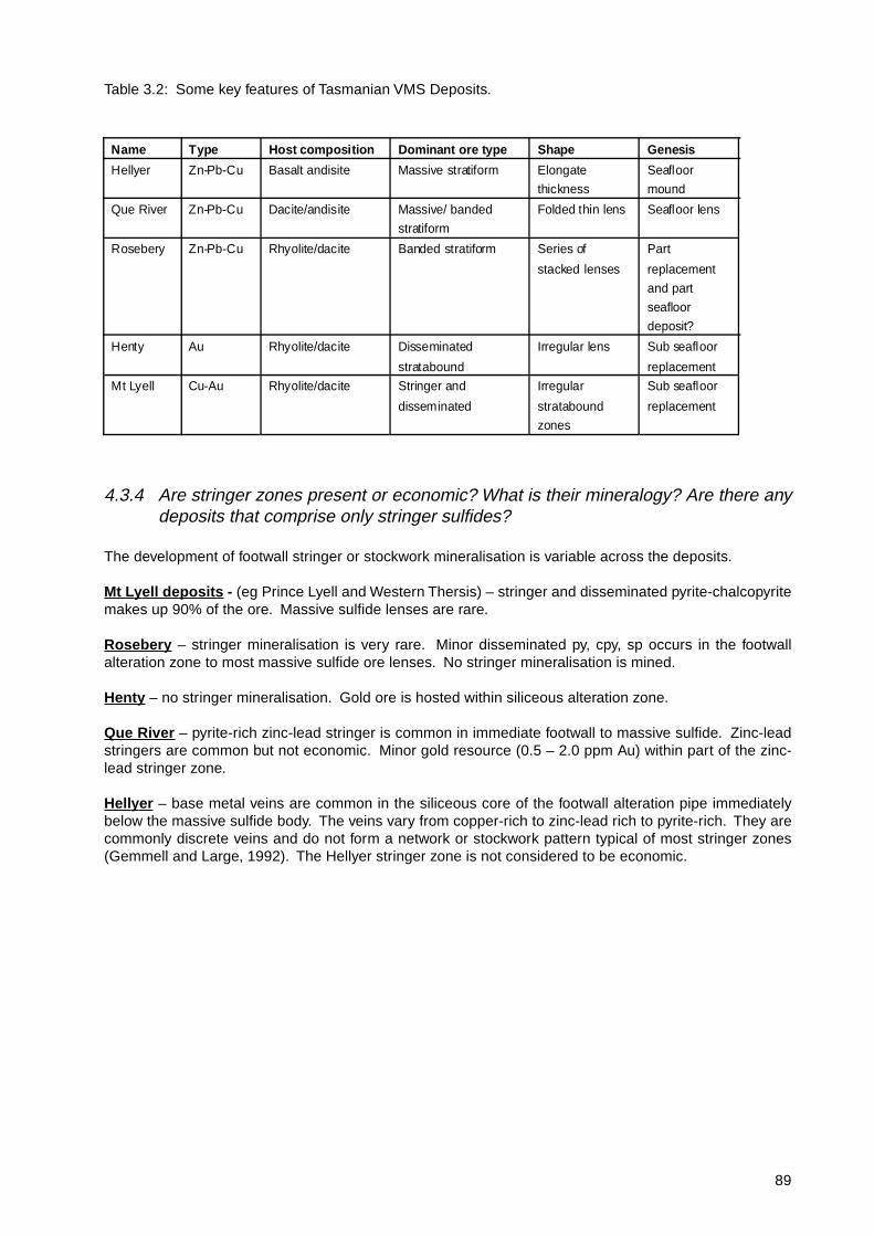
Table 3.2: Some key features of Tasmanian VMS Deposits.
4.3.4 Are stringer zones present or economic? What is their mineralogy? Are there anydeposits that comprise only stringer sulfides?
The development of footwall stringer or stockwork mineralisation is variable across the deposits.
Mt Lyell deposits - (eg Prince Lyell and Western Thersis) – stringer and disseminated pyrite-chalcopyritemakes up 90% of the ore. Massive sulfide lenses are rare.
Rosebery – stringer mineralisation is very rare. Minor disseminated py, cpy, sp occurs in the footwallalteration zone to most massive sulfide ore lenses. No stringer mineralisation is mined.
Henty – no stringer mineralisation. Gold ore is hosted within siliceous alteration zone.
Que River – pyrite-rich zinc-lead stringer is common in immediate footwall to massive sulfide. Zinc-leadstringers are common but not economic. Minor gold resource (0.5 – 2.0 ppm Au) within part of the zinc-lead stringer zone.
Hellyer – base metal veins are common in the siliceous core of the footwall alteration pipe immediatelybelow the massive sulfide body. The veins vary from copper-rich to zinc-lead rich to pyrite-rich. They arecommonly discrete veins and do not form a network or stockwork pattern typical of most stringer zones(Gemmell and Large, 1992). The Hellyer stringer zone is not considered to be economic.
Name Type Host composition Dominant ore type Shape Genesis
Hellyer Zn-Pb-Cu Basalt andisite Massive stratiform Elongate
thickness
Seafloor
mound
Que River Zn-Pb-Cu Dacite/andisite Massive/ banded
stratiform
Folded thin lens Seafloor lens
Rosebery Zn-Pb-Cu Rhyolite/dacite Banded stratiform Series of
stacked lenses
Part
replacement
and part
seafloor
deposit?
Henty Au Rhyolite/dacite Disseminated
stratabound
Irregular lens Sub seafloor
replacement
Mt Lyell Cu-Au Rhyolite/dacite Stringer and
disseminated
Irregular
stratabound
zones
Sub seafloor
replacement

90
4.3.5 What are the major textures in the massive sulfides – massive featureless, banded,brecciated? Are these textures interpreted to be primary or deformation-related.Key evidence?
Table 3.3: Textures in the ores are tabulated below:
Evidence for primary textures is hard to find in most deposits, but includes; clastic sulfide textures, colloformtextures (may occur in massive ore or veins), and sulfide banding parallel to volcanic stratification.
4.3.6 Did most deposits form on the seafloor or by replacement below the seafloor or acombination of both? Key evidence? If sub-seafloor, how far below the seafloor?Evidence?
There is a spectrum of deposits from those that principally formed by replacement below the seafloor (egMt Lyell deposit), to those that probably involved both sub-seafloor replacement and seafloor deposition(eg Rosebery and Henty) to those that are dominantly seafloor sulfide deposits (eg Que River and Hellyer).At Mt Lyell, speculation by Walshe and Solomon 1981, and Corbett (in press) indicates that the disseminatedpy-cpy lenses may have developed up to 1km below the seafloor, with patchy alteration and mineralisationextending up to the seawater-rock interface. At Rosebery, on the other hand, the sulfide replacement mayhave occurred only ten’s of metres below the seafloor, with related exhalation and barite-rich sulfide lensesdeposited on the seafloor.
Evidence for sub-seafloor replacement is provided by replacement textures (sulfides replacing primaryvolcanic textures) within the massive ore lenses and especially at the margins of the lenses.
4.3.7 Did the seafloor deposits form in brine pools, or as mounds, or are both typesrepresented, or did they form by some other mechanism? Key evidence? Is theregeneral agreement on the mechanism of formation?
There is no general agreement in the literature or amongst current researchers about the process of seafloorsulfide accumulation at either Hellyer or Rosebery.
Name Dominant sulfide ore type Comment of origin of texture Other comments
Mt Lyell Disseminated and vein
sulfides of py-cpy±bn
Combination of primary
stringer zone with deformation
related overprint veining
Very minor massive py-sp-ga in
uppermost ore lenses (eg
Comstock)
Henty Disseminated and micro
veinlet sulfides in the gold
zone
All sulfide textures are now
deformation related
Some minor lenses of massive
py and py-sp-ga commonly
stratigraphically above gold
zone
Rosebery • massive sulfide
• banded sulfide parallel to
stratification in the host
volcaniclastics
Although sulfides are
recystallised, banding is
probably primary
Pyrrhotite and magnetite
replacement occurs in deep
southern end of mire related to
Devonian granite metasomatic
fluids
Que River • massive sulfide
• banded sulfides
Banding in sp-ga rich ore
zones is parallel to cleavage
and probably related to
deformation (Large et al., 1986
Hellyer • massive sulfides
• banded sulfides
• brecciated sulfides

91
Most previous workers agree that the massive sulfide ores at Rosebery and Hellyer formed at or just belowthe seafloor (e.g. Green et al., 1981, Solomon and Groves, 1997, Allen, 1994, Gemmell and Large, 1992,McArthur, 1996, Khin Zaw and Solomon, 1999). In both cases it is considered likely that the ores formed inseafloor depressions or small basins adjacent to fault controlled hydrothermal feeder systems. Howeverthe precise nature of sulfide deposition and ore deposit evolution has been the subject of considerabledebate.
At Hellyer, McArthur, (1989), Large and Gemmell, (1992), Large, (1992) and McArthur, (1996) considerthat the massive sulfide orebody grew as a mound in a seafloor depression, with metal zonation developedby hydrothermal zone refining, in a similar fashion to that described for many Kuroko deposits by Eldridgeet al., (1983). Solomon and Khin Zaw, (1999), on the other hand, argue that the fluid inclusion evidencesuggests that the ore fluid was too dense to enable mound growth, and that the metal sulfides precipitatedwithin a brine pool ponded within a seafloor depression.
Solomon and Walshe, (1979) and Solomon and Groves, (1994) consider that the sheet-like form, stratiformsulfide banding, large size and high Zn-Pb metal content of the Rosebery deposit sets it apart from theclassical mound style Kuroko massive deposits. They argue that Rosebery is more like the large VHMSdeposits in the Bathurst district, Canada, than the Kuroko deposits of Japan. In these respects Roseberycould be considered to possess some of the features of a SEDEX deposit located within a volcanic ratherthan sedimentary setting.
Solomon and Groves, (1994) propose that Rosebery and similar sheet-like, banded, large tonnage/gradeVHMS deposits formed within a brine pool from relatively high salinity fluids which underwent reversebuoyancy on mixing with seawater. In marked contrast to this model, Allen, (1994) and Allen, (in prep)provides volcanological and textural evidence to suggest that the sheet-like form and mineral banding insome of the Rosebery ore lenses is due to sub-seafloor replacement of particularly pumice-rich unitsbelow impermeable quartz-porphyritic rhyodacitic synvolcanic sills.
In summary, the jury is still out on the exact process of formation of Rosebery and Hellyer, but most workersagree that the ores are synvolcanic and formed on, or just below the seafloor, from moderate to high salinityore fluids (5 to 15 wt % NaCl and 160° to 320°C, Khin Zaw et al., 1996).
4.3.8 List key references for each deposit
Mt Lyell deposits:
Blainey, G., 1967, The Peaks of Lyell: Melb. Univ. Press. Third Edition, 341p.
Connolly, H.J.C., 1974, Geology in exploration: Mt Lyell example: Australasian Institute of Mining andMetallurgy Proc., v.147, p.1-22.
Corbett, K.D., in press, A field study of the hydrothermal alteration zone at Mt Lyell, Tasmania: EconomicGeology.
Cox, S.F., 1981, The stratigraphic and structural setting of the Mt Lyell volcanic-hosted sulfide deposits:Economic Geology., v.76, p.231-245.
Huston, D.L. and Kamprad, J., in press, Zonation of alteration facies at Western Tharsis: implications for thegenesis of Cu-Au deposits in the Mt Lyell field, western Tasmania: Economic Geology.
Large, R., Doyle, M., Raymond, O., Cooke, D., Jones, A. and Heasman, L., 1996 Evaluation of the role ofCambrian granites in the genesis of world class VHMS deposits in Tasmania: Ore Geology Reviews,v.10, p.215-230.
Reid, K.O. 1975, Mount Lyell copper deposits: in C.L. Knights (ed) Economic geology of Australia andPapua New Guinea: Australasian Institute Mining Wade and Solomon, M., 1958. Geology of the Mt Lyellmines, Tasmania: Economic Geology., v.53, p.367-416.Walshe, J.L. and Solomon, M., 1981, An investigation into the environment of formation of the volcanic-solid-solution model: Economic Geology., v.76, p.246-284.

92
Henty - AuBeckton, J., 1999, Gold distribution within the Zone 96 gold deposit, western Tasmania: influence of protolith
and structural remobilisation. Unpubl. M. Econ. Geol. Research Thesis, CODES, University of Tasmania.Callaghan, T. in press, Geology and host rock alteration of the Henty and Mt Julia deposits, western Tasmania:
Economic Geology.Callaghan, T.J, 1998, Geology and Alteration of the Mt Julia Deposit, Henty Goldmine, Tasmania. Unpublished
M. Econ. Geol. Thesis. CODES, University of Tasmania.Halley, S.W. and Roberts, R.H., Henty: A shallow water, gold rich VMS deposit in Western Tasmania, Economic
Geology, v.92, pp.438-447.Large. C., 1989, Stratigraphy and alteration of the Tyndall Group at Henty. Unpubl. BSc Hons Thesis.Taheri, J. and Green. G.R., 1991, The origin of the gold mineralisation at the Henty prospect, Department of
Resources and Energy, Division of Mines and Mineral Resources, Report (unpublished).
White, M.J. and McPhie, J., 1996, Stratigraphy and palaeovolcanology of the Cambrian Tyndall Group, Mt.Read Volcanics, western Tasmania, Australian Journal of Earth Sciences, 43:147-159.
Hellyer – Zn-Pb-CuDowns, R.C., 1993, Syn-depositional fault controls on the Hellyer volcanic-hosted massive sulfide deposit:
Unpublished MSc thesis, University of Tasmania, 63p.Eadie, E.T., Silic. J., and Jack, D.J., 1985, The application of geophysics to the discovery of the Hellyer ore
deposit, Tasmania: Exploration Geophysics, v.16, no.2/3, p.207-209.Gemmell, J.B., and Large, R.R., 1990, Geologic evolution of the stringer zone underlying the Hellyer
volcanogenic sulfide deposit, Tasmania: Proceedings of Pacific Rim Congress 90, v.2, May 1990,p.385-392.
Gemmell, J.B., and Large, R.R., 1992, Stringer system and alteration zones underlying the Hellyervolcanogenic massive sulfide deposit, Tasmania, Australia: Economic Geology, v.87, no.3. p.620-649.
Gemmell, J.B., and Large, R.R., 1993, Evolution of a VHMS hydrothermal system, Hellyer deposit, Tasmania,Australia: sulphur isotope evidence: Resource Geology, no.17, p.108-119.
Gemmell, J.B., and Fulton, R., in press, Geological and geochemical characteristics of the footwall andhanging wall alteration, Hellyer VHMS deposit, Tasmania, Australia: Economic Geology.
Jack, D.J., 1989, Hellyer host rock alteration: Unpublished, MSc thesis, University of Tasmania. p.182.Khin Zaw, Gemmell, J.B., Large, R.R., Mernagh, T. and Ryan, C.G., 1996, Micreothermometry and
geochemistry of fluid inclusions in the stringer zone, Hellyer VHMS deposit, Tasmania. Australia: OreGeology Reviews, v.10, no.3-6., p.251-278.
Large, R.R., 1992, Australian volcanic-hosted massive sulfide deposits: features, styles, and genetic models:Economic Geology, v.87, p.471-510.
McArthur, G.J., 1989, Hellyer, in Burrett, C.F. and Martin, E.L., eds. Geology and Mineral Deposits of Tasmania:Geological Society of Australia, Special Publication 15, p.144-148.
McArthur, G. J., Textural Evolution of the Hellyer massive sulphide deposit. PhD Thesis, University ofTasmania.
McArthur, G. J., and Dronseika, E.V., 1990, Que River and Hellyer zinc-lead deposits, in Hughes, F.E., ed.,Geology of the Mineral Deposits of Australia and Papua New Guinea, Australia Institute of Mining andMetallurgy, p.1331-1339.
Schardt, C., Cooke, D.R., Gemmell, J.B. and Large, R.R., in press, Geochemical modelling of the footwallalteration assemblages of the Hellyer VHMS deposit, western Tasmania, Australia: Economic Geology.
Solomon, M. and Khin Zaw, 1997, Formation on the seafloor of the Hellyer volcanogenic massive sulfidedeposit: Economic Geology, v.92, p.686-695.
Staff, Aberfoyle Resources Ltd, 1990, Geology and discovery of the Que River and Hellyer polymetallicsulphide ores, Tasmania: Australian Institute of Mining and Metallurgy Monograph Series no.17, p.187-196.
Waters, J.C. and Wallace, D.B., 1992, Volcanology and sedimentology of the host succession to the Hellyerand Que River volcanic-hosted massive sulfide deposits, western Tasmania: Economic Geology, v.87,p.650-666.
Rosebery – Zn-Pb-CuAerden, D.A.M., 1991, Foliation boudinage control on the formation of the Rosebery Pb-Zn orebody,
Tasmania: Journal of Structural Geology, v.13, p.759-775.Allen, R.L., 1994, Syn-volcanic, subseafloor replacement model for Rosebery and other massive sulfideores: Contentious Issues in Tasmanian Geology Symposium, Geological Society of Autralia Tasmanian

93
Division, v.Extended Abstracts volume, p.89-91.Allen, R.L., in prep, Genesis of the Rosebery Zn-Pb-Cu massive sulfide deposit, Tasmania, by sub seafloorreplacement of pumiceous strata.Braithwaite, R.L., 1974, The geology and origin of the Rosebery Ore Deposit, Tasmania: Economic Geology,v.69, p.1086-1101.Green, G.R., and Iliff, G.D., 1989, Rosebery: In: Burrett and Martin (eds) Geology and Mineral Resourcesof Tasmania: Geol. Soc. Australia, v. Special Publication 15, p.132-137.Green, G.R., Solomon, M., and Walshe, J.L., 1981, The formation of the volcanic-hosted massive sulfideore deposit at Rosebery, Tasmania: Economic Geology, v.76, p.304-338.Huston, D.L., and Large, R.R., 1987, The distribution, mineralogy and geochemistry of gold and silver inthe north end orebody, Rosebery Mine, Tasmania: Economic Geology, v.83, p.1181-1192.Khin Zaw, Huston, D.L., and Large, R.R., 1999, A chemical model for the Devonian remobilisation processin the Cambrian Volcanic-Hosted Massive Sulfide Rosebery deposit, western Tasmania: Economic Geology,v.94, p529-546.Large, R.R., Allen, R.L., Blake, M.D., and Herrmann, W, in press, Alteration halo model and volatile elementhalos for the Rosebery K lens VHMS deposit, western Tasmania: Economic Geology.

94
HELLYER MT LYELL SYSTEM
from Gemmell and Large (1992)
from Large et al., (1996)
QUE RIVER
from Large et al., (1988)
HENTY
from Callaghan (in press)
Fig 3.2: Some speculativereconstructions of the morphologyof deposits prior to deformation.

95
PRINCE LYELL QUE RIVER
from Large et al., (1996) from Large et al., (1988)
HELLYERFig 3.1: Some typical cross sections ofTasmanian VMS deposits.
from Huston and Large (1989) from Gemmell and Large (1992)
ROSEBERY

96

97
4.4 Exhalites
4.4.1 Are “exhalites” (Fe, Si or Mn, units) present at the same stratigraphic level as theores? Are other styles of ore-equivalent horizons developed, eg; sulfide-bearingepiclastics, pyritic black shales, limestones? Are the exhalites true seafloorprecipitates or simply alteration (silicification?) of tuffaceous sediments? Key criteria?
Exhalites (other than the massive sulphide ± barite bodies) are very poorly developed within the lower MRVcompared to other VHMS provinces, and are absent from the peripheries of all the major VHMS deposits.All major deposits in the MRV occur in volcanic successions that are succeeeded by carbonaceous shales(mostly < 1 wt. % C) that appear from C-S relationships to have been deposited in oxic ocean waters (Gee,1970). Above the Hellyer orebody they appear to contain a small hydrothermal S component.
The upper MRV, within the Tyndall Group, contains rocks that may be exhalative, including hematite-barite-carbonate at Howards Anomaly (Eastoe et al., 1988), and possibly carbonate lenses and relict hematiticchert near the Henty Au deposit (Callaghan, 1998). Subsurface replacement and void-fill hematitic chertoccurs in conglomerates at Specimen Creek, and interdigitated with Anthony Road andesite on the shoresof Lake Newton (Jones pers. comm. 1996). The latter is interpreted by Jones (pers. comm., 1996) as partialreplacement of volcanics within metres of the seafloor. This occurrence contains some positive Eu REEanomalies, and in many respects, including very high Fe/Mn ratios, geochemically resembles ferruginouscherts from the Mt Windsor Volcanics (Duhig et al., 1992). Like these Queensland cherts, Jones alsoobserved fossilised microbial filaments.
These comprise thin hematitic cherts, associated carbonate alteration, and discrete fossilerous carbonatelenses, which are isotopically inconsistent with a seawater origin for carbon and oxygen (Callaghan, 1998).It has not yet been determined if all the Si and C –rich beds are true exhalites, or formed by infiltrationduring diagenesis, but the fossilerous units are evidence for some deposition at the sediment-water interface.The fossils themselves are typical Cambrian faunal assemblages rather than specialised vent fauna, andso if an exhalative association is to be sustained, it must be on the basis that the typical fauna was moreabundant and preservable in the vent vicinity. This is observed around modern seafloor vents, such as thePacmanus field adjacent to New Guinea.
4.4.2 Are exhalites developed at other stratigraphic levels above or below the ore position?How far above or below?
No, see above.
4.4.3 Can the exhalites be mapped along strike from the deposit (how far?), and are theyuseful for exploration? How do you distinguish ore-associated exhalites from barrenexhalites?
No, see above.
4.4.4 Is there a geochemical database for exhalites in your belt (how many samples,REE data, isotope data)?
Answered above.
4.4.5 List key references
Callaghan, T., (1998). Geology and alteration of the Mt. Julia deposit, Henty gold mine, Tasmania. UnpublishedM. Econ. Geol. thesis, University of Tasmania, 78 p.
Duhig N.C., Stolz J., Davidson G.J., and Large R.R., (1992) Cambrian microbial and silica gel texturespreserved in silica-iron exhalites of the Mt Windsor Volcanic Belt, Australia: their petrography,

98
geochemistry, and origin. Economic Geology (special issue: Australian VMS deposits and their volcanicenvironment) 87: 764–784.
Eastoe, C. J., Solomon, M., and Walshe, J. L., 1987. District-scale alteration associated with massive sulfidedeposits in the Mount Read Volcanics, western Tasmania: Economic Geology, v. 82, p. 1239-1258.
Jones, A., 1996, Chapter 8 The Lake Newton Ironstone. Personal communication (draft thesis chapter)held by G.J. Davidson.
4.5 Alteration facies
4.5.1 Have hydrothermal, regional diagenetic, and regional metamorphic mineralassemblages and textures been identified? Criteria used for discrimination?
The regionally distributed diagenetic and metamorphic alteration mineral assemblages and textures havebeen documented in detail in a number of recent works (Gifkins and Allen, in press).The Mt Read Volcanics were regionally metamorphosed to lower greenschist facies during Devonian orogeny.Felsic rocks were transformed to assemblages of quartz-albite-seriicte-chlorite±carbonate and maficvolcanics to albite-chlorite±epidote-actinolite-carbonate. The diagenetic precursors to these assemblagesare interpreted to have included clays, zeolites, k-feldspar, albite, chlorite, hematite and carbonates.
Diagenetic alteration is widespread in this dominantly submarine volcanic belt, but no regional zonationhas been recognised. The diagenetic alteration has variable intensity and patchy distribution that is dependenton primary rock composition, texture (particularly permeability and proportion of volcanic glass) and physicalconditions such as temperature and depth of burial.
Discrimination of diagenetic and metamorphic alteration from deposit scale hydrothermal alteration is basedon texture, mineralogy, distribution and chemical composition (Gifkins and Allen, in press, Large et al., inpress). Diagenetic alteration involves only minor changes in texture and chemical composition. Metamorphicalteration is likewise nearly iso-chemical, regionally extensive and usually associated with development ofcleavage or foliation.
4.5.2 What (if any) is the immediate footwall alteration mineralogy and zonation? Is thefootwall alteration more commonly in stratabound zones or as pipes? What is thedepth extent and surface area relative to the deposit?
Footwall Alteration Zones in the MRV are dominated by quartz-sericite-pyrite assemblages with locallyprominent amounts of chlorite and carbonate. They exhibit diverse morphologies and assemblages relatedto the variations in deposit styles.

99
Table 5.1:
The thin stratabound sulfide lenses of the Rosebery deposit are underlain by an extensive, stratiform,quartz-sericite-pyrite zone up to 150m thick that thins out and extends up to several hundred metres laterallybeyond ore (Large et al., in press). In contrast, the mound-like Hellyer deposit overlies a vertical, elongate,concentrically zoned footwall alteration system that was focussed by intersecting synvolcanic faults in thelargely coherent footwall volcanic sequence (Gemmell and Large, 1992). Chlorite-carbonate rich alterationzones exist immediately below, or envelop, ore in parts of both the Rosebery and Hellyer deposits. However,the pipe like chloritic footwall alteration zones characteristic of some Canadian deposits (eg. Norandadistrict) are not prominent in the MRV.
Several deposits, particularly south east of the Henty Fault, (eg. Mt Lyell, Western Tharsis) have proximalalteration assemblages that include pyrophyllite or kaolinite, or very siliceous zones with low alkali andalumina contents (eg. Henty). Recent interpretations suggest that these are magmatic related high sulfidationor hybrid high sulfidation - VHMS deposits (e.g. Huston and Kamprad, in press).
4.5.3 What (if any) is the extent and mineralogy of hangingwall alteration? Givemorphology, dimensions and mineral zonation.
Deposit Style Footwall alterationform and extent
Footwall alterationzonation
Alterationindices andvectors
Hangingwallalteration
Rosebery(Zn-Pb-Cu-Ag-Au)
Stratiform,strataboundmultiple thinlenses
Stratiform. Co-extensive with orelenses and up to150m down intofootwall; thinninglaterally andextending at leastseveral hundredmetres beyond ore.
Proximal: chlorite -MnFe carbonate ±sericite.Medial-distal: quartz-sericite-pyrite andsericite-chlorite ±carbonate.
AI, CCPI, Si/Na,Ba/Sr, Tl, Zn,Mn.
Weak, patchy:sericite-chlorite-calcite.
Hellyer(Zn-Pb-Cu-Ag-Au)
Singlee longatemound orsub basin.
Discordant, vertical,elongate ellipticalpipe related tosynvolcanic fault.Lateral extent andshape is similar toore body. Verticalextent >550m,narrowingdownwards.
Concentrically zoned:inner core of quartz-pyrite ± sericite ±chlorite gradingoutwards throughchlorite and sericitedominated zones tosericite-quartz at themargins. Smallchlorite-dolomitezones exist in upperpart of chlorite zoneimmediately belowsulfides.
AI, Na, S, basemetals, Sb, Bain muscovite, _34
S, _18O
Complex zonesextending 100mabove and severalhundred metreslaterally beyondore. A proximalfuchsi te zone isenveloped bycarbonate,chlorite-carbonateand peripheralquartz-albitezones.
Mt Lyell(Cu-Au)
Disseminated ; minormassivesulfidelenses
Large, semi-concordant zone:6km strike length,>1.5km lateral(down dip) and>1km stratigraphicdepth extent.
Central zone ofsericite-chlorite-pyrite(± pyrophyllite)grading out to sericitepyrite. Local upperzones quartz-pyr ite.
No publisheddata for entireMt Lyell field.WesternTharsis: Cu, As,Mo, S, Ba, Sr, K,white mica (lessphengitictowards ore).
None recorded.
Henty-MtJulia(Au)
Strataboundadjacent tomajor fault.Massive,d isseminated and ve inletstyle sulfides
Stratabound; up to100m thick, >1kmstrike length, ~300mdown dip.Truncated up dip byHenty Fault.
Lenses of massivemicrocrystallinequartz enveloped inzones of quartz-sericite-pyrite gradingout to quartz-sericite--chlorite-pyrite.
Intense texturallydestructive quartz-albite alteration,stratabound up to100m thickimmediatelyabove ore andthinning laterallyup dip.
100
Hangingwall Alteration zones are not prominent in the Rosebery deposit but are well developed at Hellyerand Henty. Quartz-albite zones exist above and lateral to ore at both these deposits, although they havevery different hangingwall volcanic sequences (mafic and felsic, respectively) (Gemmell and Fulton, inpress; Callaghan, in press). The mafic hangingwall volcanics at Hellyer contain zones of fuchsite, chlorite,carbonate (calcite), quartz-albite and sericite above the orebody. Empirically, it seems that hangingwallalteration is most prominent in deposits associated with synvolcanic faults.
4.5.4 What particular alteration indices (vectors to ore) have been tested or proposed?
Alteration Indices and vectors have been identified by an extensive CODES-AMIRA research project (P439- studies of VHMS related alteration: geochemical and mineralogical vectors to mineralisation, 1995-1998).A number of wholerock major element based indices have been shown to be effective as deposit scaleexploration vectors in footwall alteration zones.These include AI = [100*(MgO+K
2O)/(MgO+K
2O+CaO+Na
2O)], CCPI = [100*(FeO+MgO)/
(FeO+MgO+K2O+Na
2O)] and S/Na
2O.
An innovative graphical combination of the AI and CCPI (Large et al., in press) enables discriminationbetween diagenetic and hydrothermal alteration and mineralogically distinct zones associated with VHMSdeposits. Tl, Sb and Ba/Sr are useful trace element vectors to zinc rich deposits including Rosebery andHellyer but not in the Cu-Au systems. Tl and Sb exist at anomalous levels for up to several hundred metresabove the deposits and 2km laterally and therefore are geochemical vectors that can be applied in districtscale exploration.
4.5.5 Has a single database of alteration geochemistry been compiled for the district?(number of samples?). By whom? and is it available?
A Geochemical Database was compiled by CODES-AMIRA project P439, 1995-1998. The database includesapproximately 3927 samples analysed for wholerock major and trace elements.
4.5.6 Is there a database of whole rock oxygen isotopes? (number of samples?) Is dataavailable on H or C isotopes?
An Isotopic Database is currently being compiled in a CODES-SPIRT research project. The database todate contains approximately 210 wholerock and 100 silicate _18O analyses. Also approximately 400 paired_18O and _13C analyses of carbonate minerals. There are practically no hydrogen isotopic data. Thisdatabase remains confidential to the project sponsors until 2003, but much of the data has been publishedor reported elsewhere.
4.5.7 Have deep semi-conformable alteration zones been identified? What is theirdimension, mineralogy, and chemical characteristics? Is there evidence for metaldepletion?
Deep semi conformable alteration zones have not been mapped out or identified to date except for thoseassociated with syn-volcanic intrusions (see section 8). However alteration containing epidote-quartz, albite,quartz, hematite and disseminated chlacopyrite, sphaerite and galena have been identified in lithologiesapproximately 600 m into the footwall below Hellyer. A similar alteration assemblage, without the basemetal sulphides, is observed in andesites/dacites approximately 1 km below the mineralised horizon in theRosebery district rocks.
4.5.8 Is alteration geochemistry used to assist exploration in the district?
Alteration lithogeochemistry and isotope geochemistry has been used in VHMS exploration for about thepast 15 years (e.g. Green and Taheri, 1992). The techniques have been applied mainly in prospect scale,rather than regional, exploration programs (eg: Boco, White Spur, South Henty).

101
4.5.9 List key references
Gemmell, J.B. and Large, R.R., 1992, Stringer system and alteration zones underlying the Hellyervolcanogenic massive sulfide deposit, Tasmania, Australia: Economic Geology, v.87, no.3. p.620-649.
Gifkins, C.C., and Allen R.L., (in press) Textural and chemical characteristics of diagenetic and hydrothermalalteration in glassy volcanic rocks: examples from the Mount Read Volcanics, Tasmania.
Green, G.R., and Taheri, J., 1992, Stable isotopes and geochemistry as exploration indicators. GeologicalSurvey Bulletin 70, p.84-91
Halley, S.W. and Roberts, R.H., Henty: A shallow water, gold rich VMS deposit in Western Tasmania, EconomicGeology, v.92, pp.438-447.
Huston, D.L. and Kamprad, J., in press, Zonation of alteration facies at Western Tharsis: implications for thegenesis of Cu-Au deposits in the Mt Lyell field, western Tasmania: Economic Geology.
Large, R.R., Allen, R.L., Blake, M.D., and Herrmann, W., in press, Alteration halo model and volatile elementhalos for the Rosebery K lens VHMS deposit, western Tasmania: Economic Geology.
Large, R.R., Gemmell, J.B., Paulick, H., and Huston, D.L., (in press), The alteration box plot: a singleapproach to understanding the relationship between alteration mineralogy and lithogeochemistryassociated with VHMS deposits. Economic Geology
McPhie, J., Doyle, M., and Allen, R., 1993, Volcanic Textures – A guide to the interpretation of textures involcanic rocks. CODES SRC Publication, University of Tasmania.
Note : A Special Issue of Economic Geology concentrating on hydrothermal alteration in Australian VHMSdeposits is due for release mid 2001.
4.6 Hydrothermal geochemistry
4.6.1 Are there systematic published studies on the mineralogy, mineral paragenesisand mineral chemistry of the ores and altered host rocks. Which deposits?
Various studies have been conducted on the deposits in terms of these apsects.
Mt Lyell – Walshe and Solomon (1981), Raymond (1992, 1996), Huston and Kamprad (in press).
Rosebery – Green et al., (1981), Huston and Large (1987), Khin Zaw et al., (1999), Large et al., (in press)
Hellyer – Gemmell and Large (1992), Khin Zaw et al., (1996), McArthur (PhD Thesis), Solomon et al., (inprep).
Que River – Offler and Whitford (1992), Large et al., (1988), McGoldrick and Large (1992).
4.6.2 Are the temperature, salinity and chemistry of the ore fluid well constrained fromdeposit data? What is the quality of primary fluid inclusion data?
Temperature, salinity and chemistry of ore fluids have been well constrained for the Hellyer stringer systemapplying microthermometry, laser Raman spectroscopy, microprobe SEM/EDS and proton-induced X-rayEmission (PIXE) techniques (Khin Zaw et al., 1996). The Hellyer VHMS deposit has three synmineralisationvein stages. The primary nature of the Type I, liquid-vapour inclusions in the vein stages are evident by theoccurrence of these inclusions along growth planes of crustiform quartz crystals or within colour banding ofzoned sphalerite. These inclusions are 10-15 µm in size, and yielded homogenisation temperatures of170-220°C in early 2A veins, 165-322°C in main-stage 2B veins and 190-256°C in late-stage 2C veins.These data suggest a waxing and waning thermal history. However, the average salinity remained between8 and 11 NaCl equiv. wt % in all Stage 2 veins. Chalcopyrite-bearing primary fluid inclusions have beenalso recognised in the Stage 2B veins. Some temperature-salinity data were recorded in Solomon andKhin Zaw (1997).
The presence of CO2 (<1 mole %) in the Stage 2B veins has been also confirmed by Laser Raman
spectroscopic analysis. Semi-quantitative SEM/WDS microprobe analyses of fluid inclusion decrepitatesindicate that the Hellyer ore fluid was enriched in potassium and calcium but depleted in magnesium relative

102
to seawater. PIXE microanalysis of fluid inclusions in quartz indicates the presence of significant basemetals in the Stage 2B ore fluids compared to the Stage 2A veins.
At the South Hercules deposit, Khin Zaw (1991) and Khin Zaw and Large (1992) recognised two groups offluids: a low temperature (125o–210oC), low salinity (<4.2 NaCl equiv. wt %) fluid, and a variable temperature(125o–300oC), higher salinity (up to 15.0 NaCl equiv. wt %), CO
2-bearing fluid. The low-temperature, low-
salinity fluids are texturally associated with early Type I, two-phase fluid inclusions and are interpreted as
Cambrian fluids of volcanic origin.
Offler and Whitford (1992) recorded homogenisation temperatures of 220-310oC from two-phase, primaryfluid inclusions in quartz from the alteration zone of the P/Q lens, at the Que River deposit, but no salinitydata were given.
Inclusions in quartz from the Chester mine ranged in homogenisation temperature up to 373°C (but mostare between 115 and 160°C), with salinities between about 14 and 18 wt. % NaCl equivalent (Boda, 1991).
4.6.3 Is there any evidence for fluid boiling, give details?
Detailed petrographic investigation indicates no unequivocal fluid inclusion evidence of fluid boiling duringthe development of the VHMS deposits in the Mt. Read volcanic belt. Fluid inclusion studies at the Hellyerdeposit (Khin Zaw et al., 1996), Que River deposit (Offler and Whitford, 1992) and the VHMS deposits inthe Rosebery-Hercules area (Khin Zaw, 1991; Khin Zaw and Large, 1992) note no evidence of fluid boiling(e.g. co-existence of vapour-rich inclusions and liquid-rich inclusions in the same healed fracture). Vapour-rich inclusions that homogenise into vapour phase have also not been found.
4.6.4 What hydrothermal thermodynamic modelling has been attempted? What modellingsoftware was used (if any)?
Walshe et al., (1981) has undertaken thermodynamic modelling of the Mt Lyell Cu-Au system, withtemperature constrained by chlorite chemistry. Green et al., (1981) attempted preliminary thermodynamicmodelling of the Rosebery VHMS. Modelling to explain base metal and gold deposition for Rosebery wascarried out by Huston and Large (1988, 1989). Schardt et al., (in press) has undertaken the first detailedthermodynamic modelling of fluid/rock interaction in the hydrothermal alteration pipe below the Hellyerdeposit. Schardt reproduced the alteration zonation at Hellyer by reacting a hydrothermal fluid with andesiteusing the CHILLER software package.
4.6.5 What additional information is required to develop robust geochemical models?
Further research on mineral paragenesis, mineral zonation, fluid inclusions and stable isotopes is requiredin all deposits in order to develop robust thermodynamic models. This work is limited by the effects of laterdeformation and recrystallisation of the ores. The best deposits for further thermodynamic modelling areHellyer, Rosebery K lens and Western Tharsis (Mt Lyell).
4..6.6 List key references
Boda, S.P., 1991. The geology, structural setting and genesis of the Chester mine, northwest Tasmania.Unpublished Honours B.Sc. Thesis, Australian National University, 111pp.
Khin Zaw, 1991. The effect of Devonian metamorphism and metasomatism on the mineralogy andgeochemistry of the Cambrian VMS deposits in the Rosebery-Hercules district, western Tasmania.Unpub. Ph.D. thesis, Univ. Tasmania, 302pp.
Khin Zaw and Large, R.R., 1992, The precious metal-rich South Hercules mineralisation, western Tasmania:A possible subsea-floor replacement volcanic-hosted massive sulfide deposit: Economic Geology,Special Issue on Australian VHMS deposits, v.87, p.931-952.
Khin Zaw, Gemmell, J.B., Large, R.R., Mernagh, T.P. and Ryan, C.G., 1996, Evolution and source of orefluids in the footwall stringer zone, Hellyer VHMS deposit, western Tasmania: evidence from fluidinclusion microthermometry and geochemistry: Ore Geology Review, v.10, p.251-278.
Offler, R. and Whitford, D.J., 1992, Wall-rock alteration and metamorphism of a volcanic-hosted massive

103
sulphide deposits at Que River, Tasmania: Petrology and mineralogy. Special Issue on AustralianVHMS deposits: Economic Geology, v.87, p.686–705.
Schardt, C., Cooke, D.R., Gemmell, J.B., and Large, R.R., (in press), Geochemical modelling of the zonedfootwall alteration pipe to the Hellyer VHMS deposit, Western Tasmania, Australia: Economic Geology(in press).
Solomon, M., and Khin Zaw, 1997, Formation of the Hellyer volcanogenic massive sulfide deposit on thesea floor. Economic Geology, v.92, p.686-695.
4.7 Source of fluids, sulfur and metals
4.7.1 How extensive is the S isotope database on ores, sulfates and host rocks (numbersof analyses)? What is the range of del 34S? Do the massive sulfides and stringerzones have the same mean value and range? What is the interpreted source(s) ofsulfur?
The sulfur database is perhaps the largest of any isotope database collected in the MRV (n = 1661).However, it is strongly biased towards the known deposits and prospects (Solomon et al. 1998), with only asmall population of hostrocks, and these are probably altered. No KIBA extractions have been undertakenon MRV volcanics, which might yield primary igneous compositions from fresh rocks. A background variationof 4–8‰ for felsic rocks is inferrred by comparison to compositions in analogue basins. Instead, thebackground variation in acid soluble sulfur has been established away from deposits, and been found to behighly variable (-20–+26‰), reflecting a range of fractionation processes (biological reduction, deep inorganicsulfate reduction, etc) operating during diagenesis and fluid flow. All of the quoted data is inferred to beCambrian in origin; there is little evidence of alteration of sulfur isotope compositions during Devoniandeformation or magmatism.

104
Table 1.1:
Gemmell and Large (1993), Green et al. (1983), and Davidson et al. (2000) have all shown that stringerveins in VHMS systems in the MRV mainly have similar isotopic ranges to overlying massive sulfide lenses.However, the isotopic composition of disseminated and vein footwall pyrite which occurs lateral to distinctalteration, or is paragenetically later than main-phase ore veins, can be significantly heavier than ore sulfide(up to 45‰).
Barites in VHMS systems have____S values ~10‰ or higher than coeval Cambrian seawater, which hasbeen attributed to an origin by partial reduction of seawater in the deep circulatory system (e.g. Green etal., 1981). Such reduction also occurred in and marginal to shallow footwall alteration at Hellyer, Que Riverand Rosebery (Gemmell and Large 1993; Davidson et al. 2000), with pyrite values more positive than thatof the upwelling fluid. These pyrites are inferred to form within marginal circulation cells that were sites ofpartial reduction of Cambrian seawater sulphate.
Barites within parts of the Mt Lyell system have _34S values ≤ 30‰, thought by Solomon et al. (1988) tohave been derived by leaching and oxidation of previously precipitated sulphides, but possibly of directmagmatic origin.
The two dominant sources of sulfur in the MRV province are thought to be igneous, derived by leaching ofhostrock sulfur or from reduction of magmatic SO
2, and reduced Cambrian seawater sulphate. Although
there is evidence for circulation of seawater-derived fluids into the basement (see below), there is no directevidence as yet for contributions of sulfur from this source.
4.7.2 How extensive is the Pb isotope database on ores and host rocks (number ofanalyses and range of 206/204Pb and 207/204Pb ratios on ores?). What is theinterpreted source of metals?
Lead isotopes have been extensively applied in MRV mineral exploration, following the pioneering work ofGulson and Porritt (1987) and Gulson et al., (1987) in differentiating Devonian from Cambrian galena. Thedatabase of 603 values is therefore dominated by the compositions of small systems (410 values total),analysed to determine their affinities and suitability for further work by mineral exploration companies.There is a strong spatial variation in the isotopic composition of the systems from north to south, withHellyer-Que River at (Pb206/Pb204 =18.3–18.4; Pb207/Pb204 = 15.58–15.65), compared to the most southernexplored MRV prospects (Elliott bay) with (Pb206/Pb204 =18.05–18.26; Pb207/Pb204 = 15.56–15.65). All MRVdeposits have ‘incorrect’ Pb model ages of ~300 Ma (Gulson et al. 1991), which is an atypical characteristicfor Australian massive sulfide deposits. Gulson et al. (1991) concluded this to be evidence that Tasmaniawas not joined to mainland Australia in the Cambrian, and suggested that Pb isotopes would be useful forplacing Tasmania in a tectonic context. It is not clear if MRV deposits have anomalously young ages becauseMRV hostrocks have high µ values, or whether this is a feature of basement that was incorporated into thedeposits following deep fluid circulation. The north to south trend is likely to reflect systematically varying
Smallsystems
Henty-like
Henty Hercules Rosebery Mt Lyell-like
QueRiver
Hellyer Back-ground
Pyrite S(total S n =1661)
100 41 58 13 49 177 131 140 179
Barite S(n = 159) 12 10 1 15 48 9 64Pb (n =603) 410 36 1 3 18 107 12 17C-O(n = 376) 58 50 71 7 90 6 94Barite Sr (n= 23) 3 3 10 2 5Host-rockSr
yes yes

105
mixing of two components, as has been inferred for Lachlan foldbelt isotopic compositions generally byCarr et al. (1995).
4.7.3 Is there any other isotopic data (Os/Ir, Sm/Nd, Sr) that may assist in determiningthe source of metals?
Limited Sr data is available for the MRV (Whitford et al. 1992), and provides an important constraint to fluidcirculation. Although numbers of samples are not quoted, initial ratios (calculated at 500 Ma) for felsicvolcanics (CVC; 87Sr/86Sr = 0.7070–0.7094) and mafic-intermediate volcanics (Que-Hellyer sequence; 87Sr/86Sr = 0.7063–0.7080) are provided. The Sr isotope compositions of barites in the major deposits exceedboth these values (give 81S/86S), and also the composition of Cambrian seawater. Whitford et al. (1992)concluded this to be evidence for circulation of hydrothermal fluids into the basement to leach old continentalSr sources.
4.7.4 Is there any evidence for magmatic fluid/metal input? If so what is the key evidence?
The high salinities recorded in fluid inclusions from Hellyer (Khin Zaw et al., 1996) and Chester (Boda1991) indicate a magmatic source for the halides, because there is no evidence that evaporites existed inthe deep footwall rocks during fluid circulation associated with VHMS mineralization (Solomon, Gemmelland Yang, in prep.). The high REE contents and presence of apatite in the disseminated Prince Lyell ore atMount Lyell may also indicate a magmatic source (Large et al., 1996).
4.7.5 What further research is required to determine the source of fluids, sulfur and metals?
Determine Sr,Nd and other isotopic ratios in the fluid inclusions from the Hellyer vein sequence. Investigatealteration and mineralization associated with intrusion of Cambrian plutons apparently coeval with VHMSdeposits. More detailed anlayses of fluids in the Hellyer and Chester deposits.
4.7.6 List key references
Callaghan, T., 1998, Geology and alteration of the Mt. Julia deposit, Henty gold mine, Tasmania. UnpublishedM. Econ. Geol. Thesis, University of Tasmania, 78p.
Carr G.R., Dean J.A., Suppel D.J., Heithersay P.S., 1995. Precise lead isotope fingerprinting of hydrothermalactivity associated with Ordovician to Carboniferous metallogenic events in the Lachlan fold belt ofNew South Wales. Economic Geology v.80, p.1467–1505.
Davidson, G.J., Garven. G., Kitto, P, Berry, R.F., 2000. Geochemically discrete fluid bodies formed byconvection at the heated edge of porous seafloor aquifer. In: J.D Woodhead, J.M. Hergt, W.P. Nobleeds. Beyond 2000: New Frontiers in Isotope Geoscience, Lorne, 2000; Abstracts and proceedings,p.39–40.
Duhig N.C., Stolz J., Davidson G.J. and Large R.R., 1992. Cambrian microbial and silica gel texturespreserved in silica-iron exhalites of the Mt Windsor Volcanic Belt, Australia: their petrography,geochemistry, and origin. Economic Geology (special issue: Australian VMS deposits and their volcanicenvironment) v.87, p.764–784.
Eastoe, C.J., Solomon, M., and Walshe, J.L., 1987. District-scale alteration associated with massive sulfidedeposits in the Mount Read Volcanics, western Tasmania: Economic Geology, v.82, p.1239-1258.
Gee, C.E., 1970. The geochemistry of some black shales in relation to the origin of certain stratiformorebodies in Tasmania. Unpublsihed PhD. thesis, University of Tasmania, 153p.
Gemmell, J.B., and Large, R.R., 1993. Evolution of a VHMS hydrothermal system, Hellyer deposit, Tasmania,Australia: sulfur isotope evidence. Resource Geology Special Issue 17, p.108-119.
Green, G.R., Solomon, M., and Walshe, J.L., 1981. The formation of the volcanic-hosted massive sulfideore deposit at Rosebery, Tasmania: Economic Geology, v.76, p.304-338.
Gulson B., and Porritt P.M., 1987 Base metal exploration of the Mount Read Volcanics, western Tasmania:Pt. II. Lead isotope signatures and genetic implications. Economic Geology v.82, p.291–307.
Gulson, B., Large, R. R., and Porritt, P.M., 1987, Base metal exploration in the Mount Read Volcanics,Western Tasmania: Pt. III. Application of lead isotopes at Elliott Bay. Economic Geology v.82, p.308-327.
Gulson, B.L., Solomon, M., Vaasjoki, M. and Both, R., 1991, Tasmania adrift? Geological Note, Australian

106
Journal of Earth Science v.38, p.249–250.Jones, A., 1996. Chapter 8 The Lake Newton Ironstone. Personal communication (draft thesis chapter)
held by G.J. Davidson.Solomon, M., Eastoe, C.J., Walshe, J.L., and Green, G.R., 1988, Mineral deposits and sulfur isotope
abundances in the Mount Read Volcanics between Que River and Mount Darwin, Tasmania: EconomicGeology, v.83, p.1307-1328.
Whitford D.J., Korsch M.J. and Solomon M., 1992. Strontium isotope studies of barites: implications for theorigin of base metal mineralization in Tasmania. Economic Geology v.87, p.953–959.
4.8. Subvolcanic intrusions
4.8.1 Have syn-volcanic intrusions been identified and are they associated with VMSdeposits? What is their composition and are they composite?
A series of granite sill-like intrusions occur at depth along the eastern margin of the Mount Read Volcanics.Research in the 1970’s and 1980’s by Mike Solomon and his students (Solomon, 1976, Polya et al., 1986,and Eastoe et al., 1987) proposed a relationship between syn-volcanic granite emplacement, district scalealteration, seawater accumulation and massive sulfide formation. More recently Large et al., (1996)suggested the possibility of a direct input of magmatic fluids carrying gold, copper, iron and phosphorous toform the copper-gold VHMS deposits in the Mt Lyell district.
Geophysical evidence (magnetics and gravity) indicate that the granite(s) form a narrow discontinuousbody about 60km long and 2-4km wide toward the base and eastern margin of the volcanic pile that hoststhe deposits (Large et al., 1996, Fig 4 attached). The two outcropping parts of the elongate compositegranite body (the Murchison and Darwin granites) are strongly altered, high K, magnetite series granites.The Murchison granite varies in composition from diorite to granite (58-78 wt% S
2O
2, Polya et al., 1986)
while the Darwin granite is composed of two highly fractured phases (Jones, 1993) with SiO2 content from
74-78 wt%).
4.8.2 Classify them as shallow (<1000 m from the lowest VMS horizon), epizonal (1000-3000 m) or deep (>3000 m). Is there more than one level present? What is theirgeometry and dimensions.
The depth of the granite below the lowest VMS horizon is difficult to determine due to later structural events.Various reconstructions place the granites at a depth of 3 to 7km below the ore horizon. As stated abovethe granite is sill-like and discontinuous for 60km along strike with a thickness of 2 to 4km.
4.8.3 Are they hosted by comagmatic volcanics? Underlying basement?
The granites are hosted by comagmatic volcanics.
4.8.4 Are they identified as comagmatic to VMS-hosting strata by: a) geology; b) igneousgeochemistry, and/or c) geochronology?
The co-magmatic nature is based on geology (Polya et al., 1986, Corbett, 1992, Jones, 1993), geochemistry(Crawford et al., 1992, Wyman, 2000) and geochronology (Perkins and Walshe, 1993). The age of thegranite is 508±6 compared to the age range of the MRV of 501 to 510±7 (Perkins and Walshe, 1993).
4.8.5 Are they related to district-scale alteration zones? Key evidence?
Distinct scale alteration related to the syn-volcanic intrusions has been discussed by Polya et al., (1986),Eastoe et al., (1987), Large et al., (1996) and Wyman (2000).
Well-developed zones of hydrothermal alteration have been mapped around the margins of the Murchisonand Darwin granites. Polya et al., (1986) noted that the Murchison Granite has suffered potassic alteration,chloritisation and late calcite-edidote alteration. They recorded a zonation in alteration mineralogy from the

107
western margin (top?) of the granite, up through the volcanic section to the Farrell slates (about 2.5km ofstratigraphic section) as follows: potassic zone (K-feldspar, chlorite, epidote, calcite, pyrite, magnetite);epidote zone (epidote, chlorite, calcite, magnetite); chlorite zone (chlorite, sericite, albite, calcite); sericitezone (dominantly sericite, quartz). Eastoe et al., (1987) and Jones (1993) record potassic, chloritic andsericitic phases of alteration in the Darwin Granite and the Central Volcanic Complex to the immediate westand north of the granite. Although no clear regional zones of alteration were defined, Eastoe et al., (1987)notes that the alteration assemblages are similar to those around the contact of the Murchison Granite, andare considered to related to hydrothermal fluid circulation associated with granite emplacement nd cooling.Magnetite and tourmaline veins and breccias are localised within and adjacent to the Darwin Granite,demonstrating that magmatic-hydrothermal fluids were exsolved from the granite during crystallisation.
At the Jukes Pty prospect 12km south of Mt Lyell a minor zone of k-feldspar-magnetite alteration aroundthe margins of the granite is overprinted by a more extensive zone of chlorite-magnetite±K-feldspar±pyrite±chalcopyrite, which gives way to an outermost zone of sericite±chlorite alteration whichextend vertically and laterally away from the granite (Doyle, 1990, Large et al., 1996). Large et al., (1996)proposes that the chlorite-magnetite and sericite alteration zones around the granite are related to, andprobably connected to, chlorite-magnetite-apatite, and rela†ed sericite alteration zones around the Mt Lyelltype Cu-Au deposit.
4.8.6 Do they contain extensive areas of alteration? Do they contain base-metal and/orgold occurrences?
The granite themselves are extensively altered, especially along their margins. Early K-feldspar-magnatitealteration is commonly overprinted by chlorite-magnetite±pyrite alteration. Minor Cu-Au prospects areassociated with the second stage chlorite-magnetite alteration (Wyman, 2000), in the Darwin-Jukes area tothe south of Mt Lyell.
4.8.7 List key references
Doyle, M.G., 1990, The geology of the Jukes Proprietary prospect, Mt Read Volcanics, Unpubl. HonoursThesis, University of Tasmania, 114pp.
Eastoe, C.J., Solomon, M., and Walshe, J.L., 1987, District-scale alteration associated with massive sulfidedeposits in the Mt Read Volcanics, western Tasmania. Economic Geology, v.82, p.1239-1258.
Hunns, S.R., 1987, Mineralisation of the Lake Selina prospect. Unpubl. Masters Qualifying Thesis, Universityof Tasmania.
Jones, A,T., 1993, The geology, geochemistry and structure of the Mt Darwin – South Darwin Peak area,western Tasmania. Unpubl. Honours Thesis, University of Tasmania, 120pp.
Large, R. R., Doyle, M., Raymond, O., Cooke, D., Jones, A., Heasman, L., 1996, Evaluation of the role ofCenturian granite in the genesis of world class VHMS deposits in Tasmania: Ore Geology Reviews,v.10, p.215-230.
Leaman, D.E., and Richardson, R.G., 1989, The granites of west and north-west Tasmania – a geophysicalinterpretation. Tasmania Department of Mines, Hobart; Geol. Surv. Bull. 66, p.471-510.
Perkins, C., and Walshe, J.L., 1993, Geochronology of the Mt read Volcanics, Tasmania, Australia. EconomicGeology, v.88, p.1176-1197.
Polya, D.A., Solomon, M., Eastoe, C.J., and Walshe, J.L., 1986, The Murchison Gorge, Tasmania – apossible cross-section through a Cambrian massive sulfide system. Economic Geology, v.76, p.1341-1355.
Raymond, O., 1992, Geology and mineralisation of the Southern Prince Lyell Deeps, Queenstown, Tasmania.Unpubl. M.Sc Thesis, University of Tasmania, 161pp.
Solomon, M., 1976, ‘Volcanic’ massive sulphide deposits and their host rocks – a review and an explanation.in K. H., Wolf (ed), Handbook of Strata-bound and Stratiform Ore Deposits: II: Regional Studies andSpecific Deposits. Amsterdam. Elsevier, 320pp.
Solomon, M., Eastoe, C.J., Walshe, J.L., and Green, G.R., 1988, Mineral depsoits and sulfur isotopeabundances in the Mt Read Volcanics between Que River and Mt Darwin, Tasmania. Economic Geology,v.83, p,1307-1328.
Wyman, W.F., 2000, Cambrian Granite-Related Hydrothermal Alteration and Cu-Au Mineralisation in theSouthern Mt Read Volcanics, Western Tasmania, Australia. Unpulb. PhD Theses, University of Tasmania.

108
4.9. Hydrogeological modelling
4.9.1 Are there any published or unpublished hydrogeological models for the district orfor individual deposits? What software package was used?
Qualitative convection experiments using a Hele-Shaw cell were used in an attempt to explain the spacingbetween the major and minor Mount Read deposits (Solomon et al., 1987). The major deposits are not lessthan 20km apart, those of about one order of magnitude smaller tonnage lie within a few km of the major,and smaller deposits are even more closely spaced (e.g. between Rosebery and Hercules). Solomon etal., (1987) found in experiments that during development of large convection cells there were periods ofincreasing duration in which smaller cells operated, their magnitude and period of stability increasing withtime.
There are no formally published hydrogeological numerical models that are directly related to VHMS depositsin the Mount Read Volcanics. However, two recent conference papers are closely relevant. Jianwen Yangand Jocelyn McPhie (2000) investigated the influence of typical volcanic facies architecture in the MountRead Volcanics on hydrothermal fluid migration. Mike Solomon and Jianwen Yang (2000) established acomputational model to explain the variation in VHMS from the likely role of fractures, deep footwallpermeability and rock buffering capacity. In addition, Christian Schardt is currently working on his Ph.D.project entitled hydrothermal fluid migration in volcanic facies architecture: implications to massive sulfidedeposits. All these modelling studies have employed our own developed finite element computer software(Yang et al, 1998).
4.9.2 Are there any data on the original porosity and permeability of the volcanic andsedimentary facies in the succession?
No data on the original porosity and permeability except some limited qualitative estimates.
4.9.3 Have regional or local hydrothermal fluid pathways been defined? Using what dataor criteria?
It has been speculated that the major longitudinal (?) rift faults (Henty Fault, Mt Lyell Fault and RoseberyFault), and associated transfers (which are poorly defined) have acted as fluid conducts.
4.9.4 Have any heat sources or fluid driving mechanisms been defined?
Seawater convection was first proposed for the Mount Read and other ores by Solomon (1976), and thegranitic bodies that crop out on the eastern margin of the Mount Read province (e.g. Darwin, Murchisongranites) were later suggested as the heat sources (Solomon, 1981). Study of the alteration in volcanicrocks overlying the Murchison Granite (Polya et al., 1986) failed to establish flow paths. A significantmagmatic component for the fluids responsible for mineralisation at Mount Lyell, derived from the DarwinGranite, was proposed by Large et al., (1996). The identification of saline fluids in the veins beneath theHellyer deposit indicate a magmatic source (Khin Zaw et al., 1996), and radiogenic Sr in the barite of thisorebody, combined with S, C and O data of ores and footwall rocks suggest fluid flow penetrated thebasement beneath the Mount Read Volcanics (Solomon, Gemmell and Yang, in prep.).
4.9.5 What research is required to develop robust hydrogeological models? What computercodes are suitable and available? What computer code developments are neededto better constrain 3D heat and fluid flow modelling?
Our own developed finite element computer software can simulate 2-D and 3-D time-dependent groundwaterfluid, heat and solute transport in discretely fractured, arbitrarily-shaped earth structures. This code candeal with fluid migration driven by buoyancy force, topography and magma pumping. To simulate sedimentcompaction, a 2-D finite element software RIFT2D is available, which was originally developed by MarkPerson of the Johns Hopkins University.

109
However, extensive efforts are still required to develop robust numerical models, especially in the followingaspects: (1) need to better define the equations of state (i.e., fluid density and viscosity as explicit functionsof temperature, salinity and pressure under extremely high temperature and pressure conditions), and (2)need to couple geochemical reactions into the hydrogeological models.
4.9.6 List key references
Khin Zaw, Gemmell, J.B., Large, R.R., Mernagh, T.P. and Ryan, G.G., 1996, Evolution and source of orefluids in the stringer system, Hellyer VHMS deposit, Tasmania, Australia: evidence from fluid inclusionmicrothermometry and geochemistry, Ore Geology Review, v.10, p.251-278.
Large, R. R., Doyle, M., Raymond, O., Cooke, D., Jones, A., and Heasman, L., 1996, Evaluation of the roleof Cambrian granites in the genesis of world class VHMS deposits in Tasmania. Ore Geology Reviews,v.10, p.215-230.
Polya, D. A., Solomon, M., Eastoe, C. J., and Walshe, J. L., 1986, The Murchison gorge, Tasmania – apossible corss-section through a massive sulfide system. Economic Geology, v.81, p.1341-1355.
Solomon, M., 1976, ‘Volcanic’ massive sulphide deposits and their host orcks – a review and an explanation.Handbook of Stratabound and Stratiform Ore Deposits,v.6, p.21-54.
Solomon, M., 1981, An introduction to the geology and metallic mineral resources of Tasmania. EconomicGeology, v.76, p.194-208.
Solomon, M., Walshe, J. L., and Eastoe, C. J., 1987, Experiments on convection and their relevance to thegenesis of massive sulphide deposits. Australian Journal of Earth Sciences, v.34, p.311-323.
Solomon, M. and Yang, J., 2000, Explaining variation in VHMS ores (e.g., Hokuroku, Hellyer and Mt. Lyell):the likely role of fractures, deep footwall permeability, and rock buffering capacity, Australian GeologicalCongress, Sydney, Australia, July, 2000.
Yang, J., and McPhie, J., Influence of volcanic facies architecture on hydrothermal fluid migration, WesternPacific Geophysical Meeting, Tokyo, Japan, June, 2000.
Yang, J., Latychev, K., and Edwards, R.N., 1998, Numerical computation of hydrothermal fluid circulation infractured Earth structures, Geophysical Journal International, 135, 627-649.
4.10Exploration criteria
4.10.1How were the known deposits found? Provide a list with dates and the key methods(eg. outcropping gossan, gravity, magnetics, soil geochemistry etc).
Mt Lyell; 1883In 1881 gold was discovered in the Lynch Creek area approximately 10 km south of Mt Lyell. This attractedprospectors to the area and in 1883 S Karlson and the McDonough brothers located the Au-rich gossan ofthe Iron Blow (the Mt Lyell deposit), by following Au dispersion in drainage. Further prospecting (often bysinking shafts) located the majority of the 15 orebodies in the Lyell field during the 1890’s. Modern exploration,diamond drilling of combined IP and EM targets, led to the discovery of the Crown Lyell 3 and Cape HornOrebodies in 1956 and 1957 respectively.
References: Blainey (1954), Reid and Meares (1981), Reid (1975)
Rosebery; 1893Rosebery was discovered by T. McDonald who located alluvial gold and boulders of Pb-Zn ore. Trenchingthen resulted in the discovery of the sub-cropping massive sulphide orebody. The orebody gradually grewby drill testing down-dip extensions of the host horizon. Early deep (approx. 1 km below surface) drill tests,on >300m spacing, were unsuccessful and led to the assumption that the orebody did not continue at depthand that the ore position at the north end of the mine was truncated by the Rosebery Fault. This coupledwith a lack of suitable underground drill sites and surface access restrictions discouraged deep drillingattempts. However, in the late 1980’s declining ore reserves and re-interpretation of the geology led to arevitalised deep drilling program which was successful in intersecting K lens in 1991, P Lens in 1993 and WLens in 1996 as well as several smaller lenses at the south end of the orebody. The orebody is still notclosed off and deep exploration continues.
Blainey (1954), Reid et al. (1993), Berry et al. (1998)

110
Hercules; 1891/1894Following the discovery of alluvial Au in the Ring River in 1891 prospectors traced the dispersion to agossan (on L-M lodes of the Hercules orebody) on the flanks of Mt Hamilton, a discovery attributed to A.Conliffe. Base metal mineralisation was discovered in 1894 by J. Will who located an inch wide seam ofgossan overlying massive sulphide. The South Hercules Deposit (250m south of N lode at Hercules) wasprospected in the 1890’s (Williams shaft) and base and precious metal mineralisation were recorded, however,no further serious exploration, apart from 5 diamond drill holes, was completed until 1972 when a Turairsurvey focussed interest in the area. IP surveys and an Hg soil geochemistry led to increased interest anda 21 DDH program in 1973 led to the discovery of the precious-metal rich lens, however, it wasn’t until theincrease in precious metal prices in the 1980’s that the deposit was drilled out.
References: Blainey (1954), Throop (1974)
Que River; 1974Prospecting by T.McDonald; alluvial Au and partly decomposed sulphide boulders found in creeks, 6mshaft sunk at Gold Hill – 500m north of Que River (1922)Regional –20# stream sediment geochemistry (1972)Airborne EM McPhar H400 (1972)Recognition of coincident AEM and stream sediment anomaly near old workings at Gold Hill (1973)Griding, magnetics, VHEM, mapping and soil geochemistry – sulphides (5% Zn, 1% Cu) found in 1m deeppits (1974)Drilling (1974): DDH QR1 intersected the sub-cropping S lens (11.44m @ 2% Cu, 5% Pb, 7% Zn and 105g/t Ag). DDH QR2, designed as a test of the broad Pb in C horizon soil anomaly and a deep test of the QR1intersection, intersected the shallowly buried P Lens (3.81m @ 0.86% Cu, 13.72% Pb, 22.03% Zn, 371 g/t Ag and 3.8 g/t Au).
References: Webster and Skey (1979), Anon (1986), McArthur and Dronseika (1990)
Hellyer; 1983Following the discovery of Que River and subsequent orientation surveys, the target volcanic stratigraphy(Que-Hellyer Volcanics) was covered by detailed AEM, geological mapping, C Horizon soil sampling anddipole-dipole IP with no success (1975-1981).Trials of available deep search EM systems completed over Que River; UTEM selected (1979-1982)During 1983 a substantial part of the prospective stratigraphy was covered with UTEM. A UTEM anomaly,recognised as being intense as that over Que River, was detected on the northernmost line of this grid(100m north of previous drilling). The survey was extended and located a 400m strike length conductor,coincident in part with baritic and fuchsitic alteration (also associated with mineralisation at Que River) anda Pb soil anomaly at surface. The first hole of a three hole program, HL3, intersected 24.4m @0.3% Cu,4.4% Pb, 12.6% Zn, 157 g/t Ag and 1.9 g/t Au at 125m below surface.
References: Anon (1986), Sise and Jack (1984), Eadie, Silic and Jack (1985).
Henty; 1974-1984Systematic exploration for Rosebery Type VHMS commenced in 1968.A Grid was established then mapped and covered by ground EM and magnetics with no significant results.An old shaft with Cu-mineralisation and several zones of pyritic quartz-sericite schist were located.The grid was infilled with further mapping and a gradient array IP survey that located 17 anomalies (1972-1973).A program of pole-dipole IP, soil geochemistry (C horizon), costeaning and diamond drilling commenced totest the IP anomalies. In late 1973 costeaning over an IP anomaly, associated with a weak soil anomaly online 49N exposed a 1.5m bedded semi-massive sulphide (1.67% Cu, 1.68% Pb, 0.2% Zn, 95 g/t Ag and 1.6g/t Au). Hole HFZ5 drilled to test 120m beneath the costean intersected weak Cu-Pb-Zn mineralisation,but, significantly was not assayed for Au. A further drill hole 125m to the south also intersected 0.6m ofmassive sulphide, with 2 g/t Au. At this stage (1974) work on the prospect was abandoned.In 1982-1983 the geology of the prospect was reviewed in detail; and a further three holes were drilled(HFZ9-11). These holes intersected further narrow massive sulphides, with 1.3–7 g/t Au and one holeintersected a separate 1.1m thick Au-rich (5.1 g/t) sulphidic chert – this program marked the start of routineassaying for Au.In 1984 HFZ5 (drilled in 1974) was re-assayed for Au and returned 4m horizontal width @ 10 g/t Au. A

111
major program of diamond drilling was commenced which culminated in the discovery of the deep (300mbelow surface) Zone 96 in 1989 (HP96A, 8.5m @ 107 g/t Au).
References: Reid and Meares (1981), Purvis et al. (1983), Roberts and Fleming (1990)
4.10.2 Currently, what are the key methods used by companies to identify 1) prospectareas, and 2) drill targets?
Key methods used to identify prospect areas:
Stratigraphy: Economic mineralisation appears restricted to quiescent intervals (fine to medium grainedvolcaniclastics, often overlain by shales) at the top of the Central Volcanic Complex or in the Lower TyndallGroup.Structure: Syn-volcanic Cambrian structures that may be related to mineralisation are defined by volcanicfacies changes and gravity/magnetic data (for deep structures) and(or) using fault orientations derivedfrom detailed 3D studies of orebodies.Geochemistry: regional stream sediment coverage may highlight areas of interest, Pb isotopes are usedto differentiate Devonian and Cambrian mineralisation in outcrop and(or) soils.Geology: Locate areas of footwall (Sericite-pyrite-silica) or hangingwall (sericite-carbonate) alteration.
• drill targetsGeophysical: Ground EM (UTEM), DHEM, IP, CSAMT for direct targeting.Geochemical: Partial leach soil geochemistry. Total digest soil geochemistry where it may represent leakageup structures that intersect mineralisation. Lithogeochemical data (alteration index, Tl/Sb content etc) fromnearby drill holes or outcrop.Conceptual: Potential host stratigraphy adjacent to interpreted Cambrian structures or suitable inflectionsin Devonian structures (Henty Style).
4.10.3 What regional exploration data sets are available from the relevant governmentdepartments: aeromagnetics?, gravity?, EM?, stream geochemistry?, soilgeochemistry?, till geochemistry?, rock-chip geochemistry? Give specifications anddegree of coverage.
Regional data sets available from relevant government departments:Aeromagnetics: Whole belt covered at a line spacing of 201-500m. More recent high quality data, linespacing <200m, available for majority of central (Mt Lyell–Hellyer) part of belt, although some significantareas are still closed file (confidential)Gravity: Coverage of whole belt on a 1 km station spacing available. More detailed close spaced data(down to <100m spacing) available for central part of belt, although, some significant areas are still closedfile (confidential).EM: All surveys recorded in database (TASEXPLOR giving coverage, technique etc.) and available in hardcopy through open file reports. Only more recent data (post approx. 1995) available digitally. Majority ofbelt has been covered with modern (post-1983) airborne and(or) ground EM surveysStream geochemistry: Data compiled digitally by MRT and available on a sheet (1:25,000) by sheet basis.Whole belt covered at an average density of >5 samples/sq km, using a range of methods, but, mainly –80#.Soil geochemistry: Currently not available digitally, except for data provided to MRT as part ofrelinquishments (generally post-1996) but, majority of data available in hard copy through open file reports.Extensive modern (post-1970) data, both total and partial digest, covering the entire belt generally on200m line spacing.Rock Chip geochemistry: Data compiled digitally by MRT and available on a sheet (1:25,000) by sheetbasis. Not sure of completeness – less rigorous compilation than stream sediment data, but, samples havebeen collected from entire belt. Very wide range of elements analysed.Geological mapping: Interpretative maps. at 1:25,000 (data collected at 1:10,00; 1985-present) are availabledigitally for approximately 70% of the belt. The remainder of the belt is covered by older 1”;1 mile and1:50,000 sheets. Some of the earlier sheets are in need of partial review/re-mapping in the light of morerecent advances in stratigraphic understanding of the belt.

112
4.10.4 What percentage of the volcanic district is under shallow cover? Have any depositsbeen discovered in the covered areas?
Approximately 53% of the belt is under shallow cover (defining shallow cover as >10m of post-Cambriansediments/volcanics). This cover comprises largely quaternary glacial deposits (to 100m thick), tertiaryflood basalts and associated sediments (highly variable thickness, to 350m) and the siliciclastic Cambro-Ordovician Owen Conglomerate (up to >800m of cover). No deposits have been found under shallow(>10m) cover.
4.10.5 What exploration methods need to be considered or further researched in yourdistrict?
The consensus is that no economically significant mineralisation remains undiscovered in the depth range0-150m. All exploration is now focussed on finding buried, and probably blind mineralisation at >150m.On a regional scale improved 3D understanding of the structural and stratigraphic architecture of the belt isrequired to locate deep targets. Improved deep search geophysical techniques (e.g., EM, CSAMT, seismic?),and interpretation routines are also required.Application of partial leach soil techniques may prove useful, however, considerable research into techniquessuitable for Tasmanian conditions is required. Considerable isotopic data is available scattered through theliterature, but, a complete compilation and interpretation, of all data from the belt has not been completedto date.On a local scale improved techniques and interpretation routines (lithogeochem., isotope systematics,DHEM etc.) are required to increase the value of information obtained from every drill hole.
4.10.6 List key references
Anon, 1986. Summary of exploration in the Mackintosh District, 1969 to 1986. Unpub. Report to Director ofMines by Aberfoyle Resources Pty. Ltd. (TCR 86-2521)
Berry M.V., Edwards, P., Georgi, H., Graves, C.C., Carnie, C.W.A., Fare, R.J., Hale, C.T., Helm, S.W.,Hobby, D.J. and Willis, R.D., 1998. Rosebery Lead-Zinc-gold-silver-copper deposit. IN Geology ofAustralian and Papua New Guinean Mineral Deposits. AUSIMM, Melbourne, p418-486.
Blainey, G., 1954. The Peaks of Lyell. Melbourne University Press, Melbourne, 341pp.Eadie E.T., Silic, J., and Jack, D.J., 1985. The application of geophysics to the discovery of the Hellyer ore
deposit, Tasmania. Explor. Geophys. 16: 207-209.Halley, S.W., and Roberts R.H., 1997. Henty: a shallow-water gold-rich volcanogenic massive sulphide
deposit in western Tasmania. Econ. Geol. 92:438-447.McArthur, G.J., and Dronseika, E.V., 1990, The Que River and Hellyer volcanogenic Ag-Pb-Zn sulphide
deposits, IN Hughes, F.E., ed., Geology of the mineral deposits of Australia and Papua New Guinea:Australas. Inst. Mining Metall. Monograph No. 14, p. 1229-1239.
Purvis, J.G., Jones, M.T., Fitzgerald, F.G., and Poltock, R.A., 1983. A geological review of the TyndallExploration Licence 9/66, western Tasmania. Unpubl. Goldfields Exploration Pty Ltd Report (TCR83-1995)
Reid, K.O. and Meares, M.D., 1981. Exploration for volcanic-hosted sulphide deposits in western Tasmania.Econ. Geol. 76:350-364.
Reid, L.G., Farquhar, J.W., Georgi, H. and Lorrigan, A.N., 1993. Mine scale exploration – Deep drilling theRosebery VHMS deposit. [abs] In Wolrd Zinc ’93, p53-55.
Roberts, R.H. and Fleming, M.J., 1990. Exploration history and evaluation of the Henty gold prospect,western Tasmania. [abs]; IN Gondwana: Terranes and resources, 10th Australian Geological Convention.Geol Soc. Aust. Abstr. 25, p109.
Sise, J.R., and Jack, D.J., 1984, Exploration case history of the Hellyer deposit [abs.]: IN Baillie, P.W., andCollins, P.L.F., eds., mineral exploration and tectonic processes in Tasmania: Geol. Soc. Aust. Tasm.Div., Hobart, November, 1984.
Throop, A.H., 1974. Exploration of the South Hercules Area 1973. Unpubl. EZ Co. Report 112.Webster, S.S., and Skey, E.H., 1979. Geophysical and Geochemical Case History of the Que River Deposit,Tasmania, in Hood P.J. ed. Geophysics and Geochemistry in the Search for Metallic Ores. Geol. Surv.Canada. Econ. Geol. Rep. 31:697-720

113
4.11Research strengths for your VMS district
1 2 3 4 5
1. Tectonic and structural setting: X
2. Volcanic architecture: X
3. Styles of deposits: X
4. Exhalites: X
5. Alteration facies: X
6. Hydrothermal geochemistry: X
7. Sources of S, metals, fluids: X
8. Hydrogeological modelling: XX
9. Subvolcanic intrusions:
1 = Adequate database and extensive interpretation of data2 = Adequate database but little interpretation3 = Extensive interpretation but inadequate database4 = Moderate database and interpretations (needs improvement)5 = Inadequate database and little interpretation
4.12List of ten key references
List the major references, even if the interpretations differ from those generally accepted. The key referencesshould include those that have the major geological, geochemical etc data (maps and tables) and alsothose that contain important discussions and interpretations. Make sure the titles of key maps or mapseries are included. List key unpublished references (eg. theses) especially if they contain critical data notavailable elsewhere.
Berry, R.F. and Crawford, A.J., 1988, The tectonic significance of Cambrian allochthonous mafic-ultramaficcomplexes in Tasmania: Australian Journal of Earth Sciences, v. 35, p. 523-533.
Crawford, A.J., Corbett, K.D., and Everard, J.L. 1992. Geochemistry of the Cambrian volcanic-hosted massivesulfide-rich Mount Read Volcanics: Economic Geology v. 87, p. 597-619.
Corbett, K.D., 1992. Stratigraphic-volcanic setting of massive sulfide deposits in the Cambrian Mount ReadVolcanics, Tasmania: Economic Geology, v. 87, p. 564-586.
Gemmell, J.B. and Large, R.R., 1992, Stringer system and alteration zones underlying the Hellyervolcanogenic massive sulphide deposit, Tasmania, Australia: Economic Geology, v. 87, no. 3, p. 620-649.
Green, G.R., Solomon, M., and Walshe, J.L., 1981, The formation of the volcanic-hosted massive sulphidedeposit at Rosebery, Tasmania: Economic Geology, v. 76, p. 304-338.
Halley, S.W. and Roberts, R.H., 1997, Henty: a shallow-water gold-rich volcanogenic massive sulfide depositin western Tasmania: Economic Geology, v. 92, p. 438-447.
Large, R. R., 1992, Australian volcanic-hosted massive sulfide deposits: features, styles, and genetic models:Economic Geology, v. 87, p. 471-510.
Large, R.R., McGoldrick, P.J., Berry, R.F., and Young, C.H., 1988, A tightly folded, gold-rich, massive sulfidedeposit: Que River mine, Tasmania: Economic Geology, v. 83, p. 681-693.
McPhie, J. and Allen, R.L., 1992, Facies architecture of mineralised submarine sequences: Cambrian MountRead Volcanics, Western Tasmania: Economic Geology, v. 87, p. 587-596.
Solomon, M., Eastoe, C.J., Walshe, J.L., and Green, G.R., 1988, Mineral deposits and sulfur isotopeabundances in the Mount Read Volcanics between Que River and Mt Darwin, Tasmania: EconomicGeology, v. 83, p. 1307-1328.
114
Walshe, J.L., and Solomon, M. 1981, An investigation into the environment of formation of the volcanichosted Mt. Lyell copper deposits using geology, mineralogy, stable isotopes, and a six-componentchlorite solid solution model: Economic Geology, v. 76, p. 246–284.
Other Important Publications
Aerden, D.G.A.M., 1994, Microstructural timing of the Rosebery massive sulfides, Tasmania; evidence for ametamorphic origin through mobilization of disseminated base metals, Journal of metamorphic Geology,v. 12, p. 505-522.
Eastoe, C.J., Solomon, M., and Walshe, J.L., 1987, District-scale alteration associated with massive sulfidedeposits in the Mount Read Volcanics, Western Tasmania: Economic Geology, v. 82, p. 1239-1258.
Khin Zaw, Gemmell, J.B., Large, R.R, Mernagh, T. and Ryan, C.G., 1996, Microthermometry andgeochemistry of fluid inclusions in the stringer zone, Hellyer VHMS deposit, Tasmania, Australia: OreGeology Reviews, v. 10, no. 3-6, p. 251-278.
Khin Zaw and Large, R.R., 1992, The precious metal-rich South Hercules mineralisation, western Tasmania:a possible subsea-floor replacement volcanic-hosted massive sulfide deposit:, Economic Geology, v.87, p. 931-952.
Large, R, Doyle, M., Raymond, O, Cooke, D., Jones, A. and Heasman, 1996, Evaluation of the role ofgranites in the genesis of world class VHMS deposits in Tasmania: Ore Geology Reviews, v. 10, p. 215-230.
McGoldrick, P.J., and Large, R.R., 1992, Geologic and geochemical controls on gold-rich stringermineralisation in the Que River deposit, Tasmania: Economic Geology, v. 87, p. 667-685.
Perkins, C. and Walshe, J.L., 1993, Geochronology of the Mount Read Volcanics, Tasmania, Australia:Economic Geology, v. 88, p. 1176-1197.
Solomon, M. and Khin Zaw, 1997, Formation on the seafloor of the Hellyer volcanogenic massive sulfidedeposit: Economic Geology, v. 92, p. 686-695.