m^sfls;,^;:'?-: ;''-;-' -' : ; . - search geologyontario · varioub...
TRANSCRIPT

itf^^^^i^'V^''?'^-^^':-' ' .-*v;i^:^^;;ifP^5S^;.-v'--; ' • ' ': M^SflS;,^;:'?- :;''-;-' -' : ; .
•*!neswee53 eeie DRYDEN
GEOPHYSICAL REPORT CLAIMS ON FALCONBRIDGE PIPE LINE ROUTE
PERSHLANP GOLD MINES LIMITED
DRYDEN AND FALCONBRIDGE TOWNSHIPS
Ontario Canada
010
- by -
R. H. TAYS Noranda, Quebec
- submitted -
April 16,1970
by
A. S. BAYNL S COMPANY Consulting Engineers
A. S. Bayne, P.Eng. - Ontario

^^^f ̂*:^e ; -' ; : ;-L u^-'" ' :/:"' : . ' ' . : "'
|4: Geophysical Report Completed - May 28,VV'iPershland Gold Mines Ltd. Revioed 6 SubmittedC;{,;.",i.;-"-.v'---. .' - '-j^f.; . ,..-,'-* '' -. . :
iv ' SUBJECT INDEX-
'•'' ' IIIIIIIIIIIHIIIIIIBIBIIIBBIllBMMta*
Letter of Transmittal |||| ||||||||| Illlll III 1 1 lit^ viHUilff IT jf •••••••1 m l IIBBIIIIIIIIIIIIIHJIII | |j HI m
Location S Access 010CProperty PreparationTopography 6 VegetationTheory S Method of Surveys
MagnetometerElectromagnetic
General GeologyGeophysical Interpretations
North Grid - Magnetometer s, E . M.Centre Grid - Magnetometer 6 E. M.South Grid
Declaration - R. H. Tays
***********t
AppendixStatistical Data {Line Grid) IPersonnel Employed II
IIIAssessment Work Breakdown III
***********
MAPS (See back of
Figure 1 - Location Map - Scale 3 miles ^ 1 inch
t
4
1969- April 16, 1970
Page(i)1-234-555-85-66-888-128-1010 - 1111 - 1213
Page14152216 - 22
Report)
Figure 2 - Grid Locations - Scale 1/2 mile - l inchPlan - Magnetometer Survey - Nortli Grid - Scale 200 feet - l inchPlan - E.M. Survey - North Grid - Scale 200 feet - l inchPlan - Magnetometer Survey - Centre Grid - Scale 100 feet ~ l j.nchPlan - E.M. Survey - Centre Grid - Scale 100 feet ~ l inchPlan - Magnetometer Survey - South Grid - Scale 200 feet - l inchPlan - E.M. Survey - South Grid - Scale 200 feet ~ l inchGeological Maps of Parts of Falconbridge S. Dryden Twps. Scale 1000 ft.*5 ! in.

P&vS;-BAYNE ft COMPANY '0 ™""*"0 6™ceT WEST
OTORONTO l. CANADA
•NSUUTINO CNCINEEnS . 368-3283
ADDRESS ALL CORRESPONDENCE * 45 STRATHALLAN BLVD.. TORONTO 12. CANADA * 483-6703
April 16, 1970.
The President S, DirectorsPershland Gold Mines LimitedSuite 420159 Bay StreetToronto, Ontario
Re: Geophysical Survey - Dryden ___and Falconbridge Townships
Gentlemen :
In March 1969, we arranged to have the geophysical crew, headed by R. H. Tays, based at Noranda, Quebec, to carry out geophysical sur veys on the seven claims across which an easement was given to Falcon bridge Nickel Mines Limited for a pipeline to its new iron plant.
The reports and maps were turned over to the undersigned several months following the completion of the survey in May 1969. Following this, several revisions to the maps were completed by the undersigned, which delayed compilation of the report and maps for final submission.
tfe have now completed this and submit the report and maps here with. We have also completed the necessary documents for filing the work for assessment work credits.
Respectfully submitted,
A. S. BAYNE 6 COMPANY
ASB/mj Enc.

-l-
BUHHARY
jn late Knrch 1969, the Horanda based, Falconbridge geophysical
crew were asked to carry out geophysical surveys on three blocks of
ground in Falconbridge and Dryden Townships. These three blocks lay in
the path of e propoced water pipe line and the objective was to dotomine
if any mineralization of coianercial value lay in the path of the pip*
line. On March 28'Ji, a crew started laying out picket linea end surveying
the three gride. The work was conpletod approximately April 27'**
Access to th* property was by means of rt four wheel drive truck
over very poor bush trailn, Inter in the course of tho prograa, the
condition of the roads deteriorated to a point where the truck no longer
could bo uued. A track vehicle VMB used to coaplite the 41cb. I^e to
tho traneportntion difficultien, the cont of the project wtis nore thnn
uae expected.
The bace lines were to bo laid out parallel to the pipe line at
a dintftnce of approximately three hundred feet to one cidc or tho other.
Sotae difficulty WAD encountered in establiuhing tho Tovmchip, Concesaion
and Lot linea due to tho lock of large bueh und the f ne t that due to
variouB roncona there nre very fou Lot pot;ts renainjiij; in the nrea. Tlio
correct cluira corners wore eventually Iced tod and tho br-se lincu laid
out us directed. Tho picket linos were to h.-ivo been lcid out by
picketing and it was thought that very little cutting would bo nectGC'iry!
liouftvor, when the t^n be^n loying out the lir'jfi, il. vno foun^i that
although thrre were no big treoe, tho abundance of uhruobery nade it
neceosRry tf actually cut linos.

Following tho establishment of the lines on the thr*e
prospective blocks, n magnetometer and horizontal loop E,M. survey
was carried out en ench.
North Gridi Tho.results of the surveys have not indicated
any significantly strong anoanlies, however, there are several weak
anomalous zones which correlated with the magnetic and geological
information appear to be duo to faulting and other structural effects.
A ungnatic anonaly in the north pnrt of this grid t on Claio C153710.
has o corresponding electromagnetic response however the K.M. results
do not suggest tho presence of nny signific;int onount of Mineralization,
Center Grid; The olectronagnetic survey carried out over this
grid has indicated consistent but woukly conductive zones traversing
tlie property froci tho south to the north. This conductor p-irnllele the
magnetic trend nnd is directly nsnocii'ted with a fault zona which
appears on tho geology n:ij). It should bo noted that duo to the r-ttoll
size of thlo grid, the ranp wan drafted on the cc^lo one inch to one
hundred feet, which tends to exaggerate the E.)!, profile. Thic zone
is not conuirtered important.
Sout.]^j?ri.d: The rc.-.ultn of the n.ignetoaeter survey have out
lined o connir.tnnt trend to the northwest, hov?ever, there arc rio
eignific.-intly high r.njjnetic.'j ns:;oci.'itcd. The K.)1. survey ha o only
resulted in two very weakly conduct5.vc zones, one of vhich'appears to
bo iiB^ocj.atcd with the southerly edge of n r;.-: gr. c tic lew. 1'hc recent
zono in very wcnk, inconsistent and par.'O.leln tho jrs'cviout.ly nontioncd
sono. Ueithor of these conductors are considered of nny injxjrtnnce.
It is the opinion of tho writer thnt no ninoralizntion of
hp.a been indicated by tho surveys.
--' ~'''
-3-
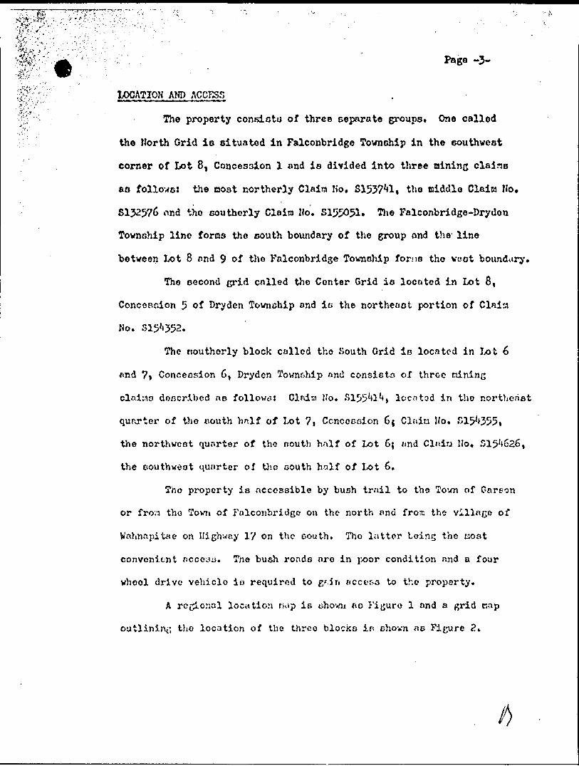
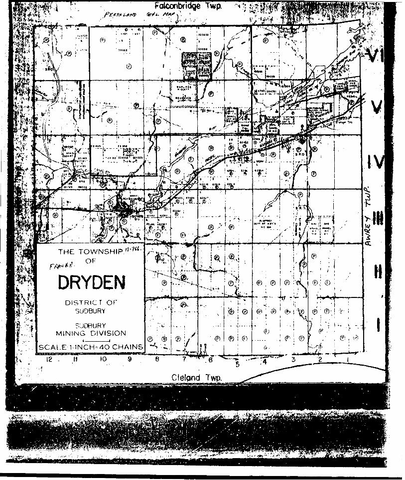
LOCATION AND ACCESS .
The property consistu of three separate groups. One called
the North Grid is situated in Falconbridge Township in the southwest
corner of Jx)t 8, Concession l and is divided into three mining claine
aa follows: the nost northerly Claim No. S15371*!! the middle Claim Mo.
S132576 nnd the southerly Claim Ho. S155051. The Falconbridge-Dryden
Township line forms tho south boundary of the group and the line
between Lot 8 and 9 of tho Falconbridge Township forns tho voot boundary.
The second grid called the Center Grid is located in Lot 8,
Concession 5 of Dryden Township and is the northeast portion of Clnisi
No. 515*4352.
The Bouthorly block colled tho South Grid is located in Lot 6
and 7j Concession 6, Dryden Township and consists of throe mining
cl.iitto doncribed ao follows: Clfdtn JIo. ^155^1^ t loco tod in tho northeast
qurxrter of tho couth hnlf of Lot 7i Concession 64 Clnin Ho. S1^355*
the northwest quarter of the nouth half of Lot 6; and Claim Ho. S15'i626,
the southwest quarter of the south half of Lot 6.
Tho property is accessible by bush trail to the Town of Garson
or fron tho Town of Falconbridge on the north and frors the village of
Wahnnpitae on Highway 17 on the oouth. Tho latter Loins the nost
convenient r.cccsjj. Tne bush roads are in poor condition and a four
wheel drive vehicle io required to g'.in access to tho property.
A regional location nap is uhowji ao Figure l and a grid
outlining tho location of the three blocks in chown as Figure 2.

PROPERTY PRKPARATIOH
Duo to the lack of large treea in the area, cone difficulty
was encountered in the location of Lot and Concession lines, however,
once this wns achieved, grid lines were luid out on the individual
blocks BB described below:
North Grid: A base line was laid out in a north-south direction at a
bearing of north 110 -30 rainutea vest. The base line was turned off
froo the Falconbridgo-Dryden Township line, two hundred feet yest cf
the lino between Lots 7 and 8, Following the establishment cf the
base line, picket linos were turned off at two hundred foot intervale
at 90" to the bntje lino and cut east and west until they intersected
eaot nnd west boundaries respectively. The picket lints vere then
chained off at one hundred foot intervals, cortraencing at O cu the baso
line and increasing mmerically cast and vest.
Center Grid: Tho base line vos l.;dd out in a north-south direction
along a road on a bearing of north J0 oast. It was turned off fron
the north boundary of Claim Ho. S15'i^2, approximately one hundred rinrt
twenty five feet west of Lot line 7 and 8. Picket linos were then
turned off at 900 to the base line at intervals of two hundred feet
and cut e.-ist to the line between Lots 7 and 8 and to five hundred feot
west on thu b.io3 line. The pickot lines wore then chained off at one
hundred foot-int-;rv;ls ccnnoncing ot O on the bnso lino and increasing
numerically east and wast.
South Grid; The bnso line wao laid out in a northwest to southeasterly
direction on a bearing of north ^l0 wost starting on the west boundary of
Cl.-iin Ho. 5155**!^ nprroxiriatcly tv:o hundred feet couth of the north

1^;*-^':;''' "" -V-': ^ '' ' . Page -5-
*' i. i \ ' boundary. The O point was established at seventy feet southeast of
this point. Following the ostnblishnent of tho base line, picket lines
were turned off at two hundred foot intervale starting at line O in the4 ,
northwest and extending to line 28E in the southeast corner. Picket lines
were then extended to the northeast and tho southwest until they intersected
the boundaries of the group. Lines wore then chained off at one hundred
foot intervals beginning at O on the base line and increasing numerically
to the northeast and oouthweot respectively.
TOPOGIUPHY AMP VSGETATION
All three grids are located in oreno of rather irregulm- terrain.
Although there are no largo hills, t)ore are several rather steep gru^ea
and sharp valleys, Tho area is about 2/3 overburden covered with very
light vecototion. There nra no treeu of nny significant si'/e, however,
there is u considerable nnount of cia-ill shrubbery throughout the property.
Before tho lines wore laid out, it was considered possible to only picket
tho lines without cutting, however, it wne found noceseary to remove a
great deal of tho ehrubbery in ordor to nake passable linea. This
shrubbery will also be cruch r.oro evident v/hon tho leaves ara on the trees.
Ha gno.tpac tergalr v oy
In carrying out tho nw gao tome ter survey, n fi'narpo )IFI Flux ja to
piagnotomotor WPB employed. *tiio ir.strunent operates by neann of a flux
gate eynten which is ojjerntcd by battery. The rendinso were tnken fron
o. DO ter on tiie face of the inolruaent and cro read in gnma values.in f-fft*~ n*f~ txrif't
Therefore, no correction is neceanary for the diurnal /md instruufiv; ;h*ift.

Pag* -6-
The fluxgate system works on the principle that a battery
current is passed through two coils which are arranged within a secondary
winding* These coils ore BO arranged that the nngnotic field cet up in
then is equal. If, however, en external magnetic field exists, it
creates an in~balance in the systeta which results in a nea BUT able voltage
which is proportionate to the strength of tho external field. The
voltages are neasured on a raeter on the face of the instrument which is
divided in ganoa values. A detailed explanation on the fluxgate oystcn
can bo found in "Applied Geophysics for Engineers and Geologists", by
Griffith and King.
The stations to be uaed for diurnnl and instrument drift control
were estobliched nlong tho bnco line. Follov/ing this the readin&o vero
taken at fifty foot intervals along all picket lines and along the bras?
line. Following the necessary corrections the readings vere plotted in
gamma values on the map.
The accuracy of this instrument, in considered plus or Minus 0.5/4
of full scale on tho 1,000 to 10,000 ganrta ranges nnd l.CfJ of iull sc.-ile
on tho JO,COO to 100,000 gama ranges. The sensitivity is 20 gnnna/ciSv.
en tho 1,000 garwa scale, decreasing proportionate to the increased neale
range.
?Qfttal Loop K.^H*. Survey
The survey vas carried out using a horizontal loop Iluntoc Hod el
kn J JX 111 instrument which operates in the folloving nnnner: t* trnns-
nitter coil ia carried along a line followed by a receiver coil and console
unit. Tho coils vere separated by a two hundred foot length of conrcnr-olion
"7"
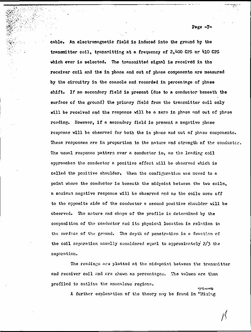
cable* An electromagnetic field is induced into the ground by the
transaitter coil, transmitting at a frequency of 2,^00 OPS or **10 CPS
which ever is selected. Tho transmitted signal is received in tho
receiver coil and the in phase and out of phase cooponente are neasured
by the circuitry in the console and recorded in percentage of phaee
shift. If no secondary field is present (due to a conductor beneath the
surface of the ground) the prinary field from the transmitter coil only
will be received end the response will be a zero in phnoo nnd out of phrse
reading. However, if a secondary field is present a negative phase
response will be observed for both the in phnse and out of phnco conponents.
These responses are in proportion to the nature and strength of the conductor.
The usual response pattern over n conductor is, as the leading coil
approaches tho conductor a positive effect will be observed which is
called the positive shoulder* V/hen tho configuration was coved to a
point where the conductor is beneath tho midpoint between tho two coils,
a naxiinura negative response will bo observed nnd os the coils tiove off
to tho opposite side of the conductor e second positive shoulder will be
observed. Tho nature nnd chnpo of the profile is determined by the
composition of the conductor rnd ito physical location in relation to
the surface of tho ground. Tho depth of penetration is n funct5.cn of
the coil separation uGunlly considered equnl to approxinntely 2/J the
separation.
The readings ^ra plotted at the Bid-point between the trana-oitter
and receiver coil nnd era chown os percentages. Tho values are then
profiled to outline tho anomalous regions.
A further explanation of tho theory Ray be found in "Hiui'ig

' , ' ' ' Page -8-.Geophysics, Methods in Gecchenietry and Geophysics" by D. 5. Parasnie.
In this eurvey, the readings were taken at intervale of fifty
feet along ell picket lines.
GHOLCQY
RqferenceDi O. D. H. Map Ko. 1957-5 - Falconbridge Township
O. D. H. Map No. 2017-1962 Broder, Dill, Neelon, and Dryden
Townshipo*
The area covered is underlain by quartzite and conglomerate
intruded by Bill-like nncees of Sudbury ga^ro tini^ northwest trending
dykoa of olivine diabase.
All these rock unite have been effected by northwest trending
sheurn end faulte.
llprth Grid
Survey; Tlio roeults of tho survey carried out over thio
grid have beon plotted to a b"ckground nt approxinatoly eight hundred
The nost obviouo ti-jgnetic rccj-onoes occur in the northern psrt
of the group on Lines ?.?M to 28N in the itcncdiato area of the Base lino.
The cagnctic intc:i3itien vary from positives of 5^*00 gat '-^B to nogntiveo
in tlie order of 2000 g.inm r)B. The nature of tho negatives to the
poeitivo.T eugger.t a dip to the vest.
Apparent northwest trending truignetics r.t the south end of the
group are very likely duo to a diabase dyke ehovn on the geology map,o Further coranents on the n^gnctic results will be in c

Page -9-
vith the E.K. results.
The nap le shown as Plate 1.
Horizontal Loop E.H. Surveyt
Elec tronagne tic Survey l - The horizontal loop electromagnetic survey
carried out over this grid has outlined several indicated conductors
with a consistent trend to the north. Although none of these can bo
considered very significant, five of the better have been selected nnd
numbered for comment.
Conductive zones No. l, 2, nnd 3 appear to lie along the sans
horizon, although they lock consistency they are thought to be due to
a weakly conductive shear or fault zone. There is no fault chown on
the geology nap however there are other faults trending parallel to it
suggesting the possibility of a shear ?one.
When we compare the results over this sone with the nagnctic
survey, we find that conductor Ko. l correlates very well with the
zones of high magnetic intensities on line 2'tN and 26N. Although ther;e
are by far the strongest E.M. responses the alreost non-exist*mce of out
of phase response suggests that it is either due to a concentration of
magnetite or possible due to rdsalinement of ;ho coils, the fornor being
core likely. (A good nnonnly over a sulphide concentration usually hns
a ratio of 2 to l in phase to out of phctse). At this point the zone is
intersected by faulting which h-is displaced it about 100' cnst. The H.H.
profiles also suggest a dip to the west.
As we follow this zone to the north and south we find it to be
inconsistent and isostly of in phase response. There is r.o significant
magnetic correlation.
'•-'/''^'':': ;': ; :',; ' ; - Pago .3.0-
!r,'.'.1^..'*;- - 1 ' 11 ' -' r
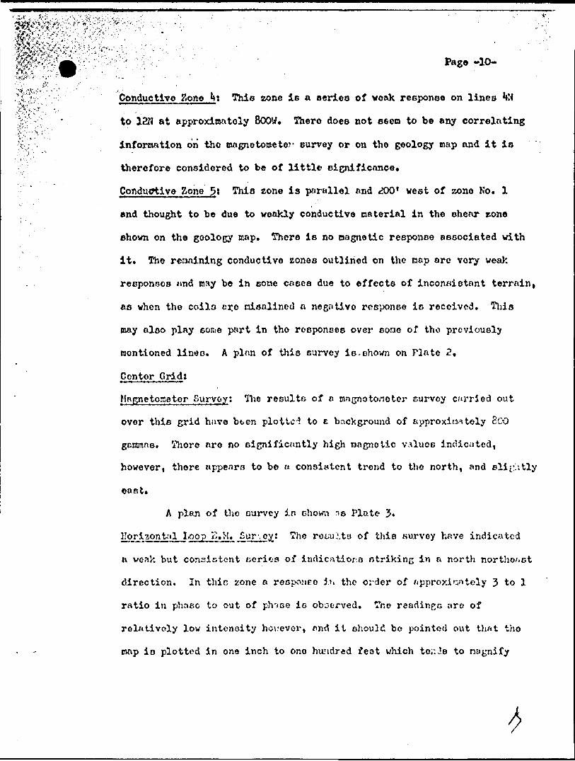
^;.K Conductive Bone Ht This zone is a series of weak response on lines HH
^. :! ; ' to 12M at approximately BOOW. Thero does not o&eta to be any correlating
t ; information on" tho magnetometer survey or on tho geology map and it is
therefore considered to be of little significance.
Coftdugtive Zone ^: This zone is parallel and **00' west of zone No. l
and thought to be due to weakly conductive material in the shear rone
shown on the geology map. There is no oagnotic response associated with
it. The remaining conductive zones outlined on the cap are very weak
responses mid may be in sone cases due to effects of inconsistent terrain,
as when the coilo cr.e nisalined o negative response is received. This
may also play some part in tho responses over sonic of tho previously
mentioned linen. A plnn of this survey is.shown on Plate 2 ,
Centor Grid:
Hagne torse tor Survey; The results of a magnetometer eurvoy carried out
over this grid have bten plotted to e background of approximately SCO
ganmne. Thore are no significantly high nagnotic VA!UOB indicated,
however, there appears to be H consistent trend to the north, and eli^itly
east*
A plan of tho curvcy in chown i e Plate J.
Horizpntril Loop K.M. Eur'.oy! The row.iitu of this survey have indicated
n vcak but consistent series of indicatior.o ntriking in a north northeast
direction. In thic none a recponpo ih the order of hpproxJ.r.ntely 3 to l
ratio in phneo to out of ph'jse is observed. Tho readin^c nro of
relatively low intensity ho\.'ever, and it should be pointed out that tho
map is plotted in one inch to one hundred feat which torJ.e to nagnify

' r : : : . Page "n-' , ' -' ' "
the profile. When ve compare the results of this survey to the
magnetometer survey, we find that this conductive zone lies nlong n
weak but consistent line of magnetic chnngo from below background to~ '
elightly above. There is a paralleling fault shown on the geology nap
and it ia more than likely that the E. K. responses tire due to weakly
conductive Materials along the fault. Two other anomalous zones are
outlined as Ho. 2 and Ho. J. These zones are on the northwest side of
the property ond have a strike direction parallel to No. 1. They are
associated with magnetic trends similar to that described for Ho. l,
and are not considered significant.
A plun of the survey is shown in the report as Plate **.
cir Survoy: The results of this eurvey ns chown on Plate 5 of
the report ic plotted to a bnck(;round of approximately 800 COI;VWR. The
reuults outline n very consistent northwesterly trond w!:ich oppcnr UK.
narrow ia?ignetic bands troverning the property in that direction. There
oro no strongly anonnlouo readings, however there is ono consistently
low zone e-pprox3.r.vitely four hundred feet wide traversing the property
parallel to the otriko on the northeast corner. The low ie thought to
be the diabase dyke shown on the geology cup. Ho further connents vill
be Dride on the rocults of this survey except in correlation with the
horizontal loop K. J', rooultu.
l?ori?.pjntal .l:OOJPL...^*j^*. /l" 1* 0̂^* '' o significant anomalous zones have been
outlined by this survey, however, two zones of weak and inconsistent
indications have been outlined, both of which parallel the magnetic
trends. The nout northerly conductive zone appears to lie alon,^ -Use

Pago -12-
eouthera edge of the previously nentioned magnetic low. The nore
southerly conductive zone lies parallel and elightly south of the base -
line. There does not appear to be a significant nagnetic correlation hore
except there is a rather inconsistent zone of magnetic intensities slightly
above background lying along the path of this imonaly,
Neither of these conductors can be considered of much significance*
The .erratic in phase responses are through to be due to irregularities in
topography creating variation in the separation of the coils. A plun of
those reBulto is shown os Pinto 6,
Respectfully submitted,
H. Toys

P E C LA R A ? I O N^
*
I, Reginald H. Taye, the undersigned, herewith certify I
have had the following txperience in geophysical surveying,
employed as an instrument operator, party chief, and field cupor-
lisor. Four yea^a with Goo. Explorers Limited, 1953 to 195? under
the Bupervision of Mr. Donald. J. Salt (professional engineer) wnd
twelve yeare with Falconbridge Nickel Hineo Lied ted, 1957 to 19&9.
During thin period I worked under the ouporvipion of Mr. D. J, Salt,
'- rof. eng.) nnd Mr. H. David HncLean (professional geophysicist).
I hnvo perBonnlly cuporviood the work outlined in the above
report.
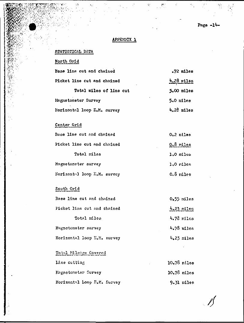
APPENDIX l
Base line cut and chained
Picket line cut and chained
Total miles of line cut
Magnetometer Survey
Horizontal loop E, M. survey
Center .Grid
Booo line cut nnd chained
Picket line cut nnd chained
Total niles
Magnetometer survey
Horizontal loop K, M. survey
South ..Grid
Bo se line cut and chained
Picket line cut and chained
Total miles
Magnetons ter ourvey
Horizontal loop H.M. nurvey
Line cutting
Hngno tone tor Survey
Horizontal Loop K.K, Survey
.72 miles
.28 oileo
5.00
5,0 oilea
*.28 miles
0.2 tsilee
0.8 nilee
1,0 nileo
1,0 tnilCB
0.8 nilee
0.55 niles
Page -l4*-
U.7B mi leo
**.?8 adles
Jt.aj niles
10,78 nilee
10,78 niles
9.31

Page -
'.s';.,'
PSR50I1UEL EMPLOYED
Karcel ifcnurd,
J* L. Leclerc,
Cloude Sinard,
Robert Craig,
H. H. Tnyo,
A. Brewer,
Mra, A. Brewer,
APPBfDIX 11
Inetrunont Operotori280 Lmizon St., Kouyn, Quo.
Instrunent helpor,28 Horne St., Rouyn, Que.
Inetrunenc operator,^6 Frontennc St*, Kingston, Ont.
Instrument helper,(•C? Murdoch Avo., Noranda, Que.
Supervisor,685 Murdoch Avo., Itaraada, Que.
DraftDrr.nn,697 Murdo ' Ave., Hornndn, Quo,
Typict,697 Murdoch Ave., Hor-^nda, Que.
^3V'S
"-'AY ?. 'y, c '
Pag* ~
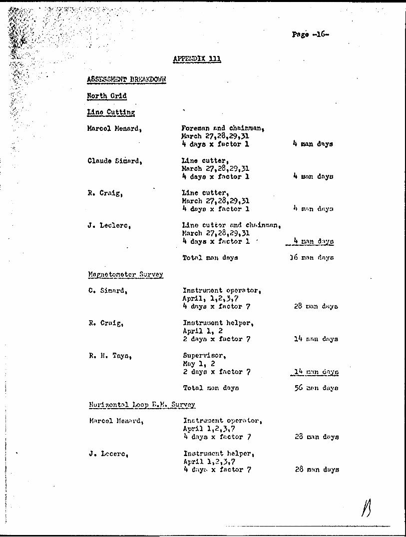
ASSESSMENT -BRKAKDOtfH
Horth Grid
line Cutting
Harcol Menard,
Claude Sinard,
R. Craig,
J. Leclorc,
Survey
C. Sinnrd,
R. Craig,
R, H. Tayo,
APPEI,T)IX HI
Foreman find chainman, Harch 27,28,29,31 4 days x factor l
Line cutter, March 27,28,29,31 ^ days x f ne tor l
Line cutter, March 27,28,29,31 ** days x factor l
Lino cuttor nnd chftinrsnn, Harch 27,28,29,31 4 days x factor l '
nan days
Instrunont operator, April, 1,2,3,7 ^ dnya x factor 7
Instrument helper,April l, 22 dayo x factor 7
Super\dsor,Kay l, 22 daye x factor 7
nan d*ya
loon dayo
Total raan daya
Kuri tonit?il .Loopi^t H* Survey
Inctroacnt operator,April 1,2,3,7k dayo x factor 7
Instrument helper,April 1,2,3,7k dayi. x factor 7
Marcel Men^i'd,
J* Lccerc,
16 days
28 tsan dnyo
ninii days
cinn day e
23 oan dnys
28 !3!m duys

VjV.1 '-" \ -
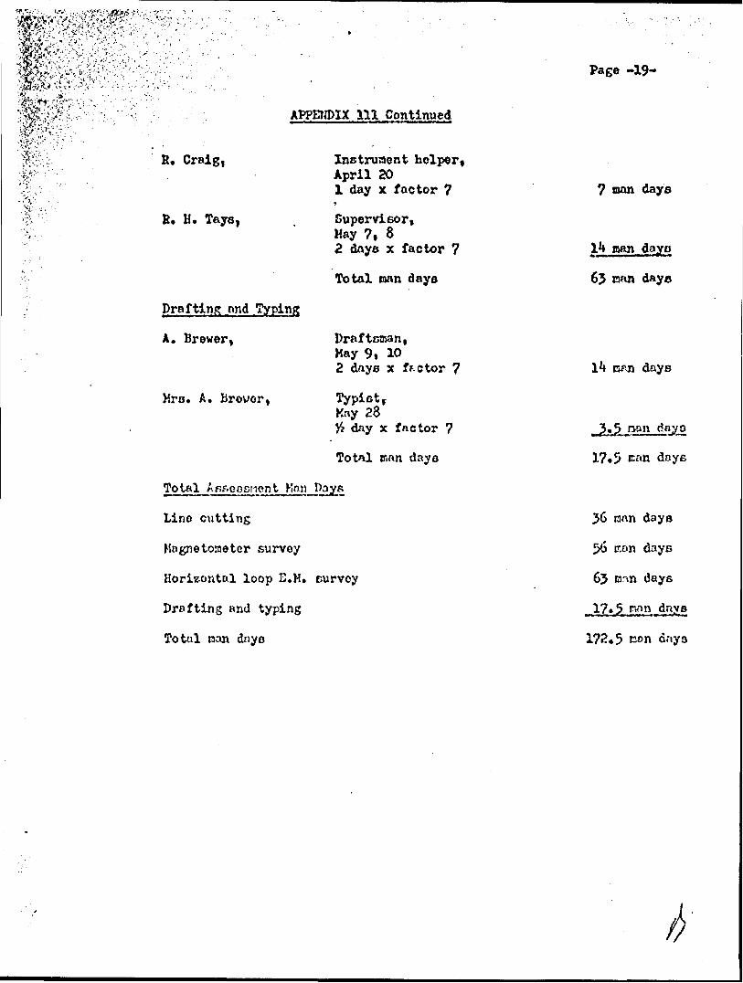
K* Craig,
B* H. Toys,
Drafting ond Typing
A. Brewer,
Mrs. A. Brcwor,
To tnl nsBensaen t
Inotruraent helperApril 3, 72 days x factor 7
•*
SupervisorKay J, 52 days x factor 7
Total nan days
Draftsman,May 6, 72 days x factor 7
Typict,May 28)4 day x factor 7
Total Man days
Lino cutting
Magnetometer survey
Horizontal loop E, K. curvoy
Drafting and typing
Total man dayo
Pago -17-
nan days
.n doy
man days
duye
an dny
17*5 nan
16 nan days
56 BSD dnys
S4* nan dnyo
173*5 nwn days

m.'x*
APPENDIX 111 Continued
Page -18*
South Grid
Line Cutting
H. Menard,
R. Craig,
C* Sinard,
J. Loclerc,
K[apne tono t or 3u ryev
C. Sinard,
R. Craig,
R. H. Tays,
Foreman and Chainman,AprU 8,9,10,11,12,13,lM5,169 days x factor l
Lino cutter,April 8,9,10,11,12,13,1^,15*169 daya x factor l
Line cutter,April 8,9,10,11,12,13,1^,15,169 days x factor l
Chainman,April 8,9,10,11,12,13,1^,15,169 days x factor l
Tot*il nan days
Inotruraent operator, April 17,18,19,20 J* days x factor 7
Instrument heloor, April 17,18,19 3 daya x factor 7
Supervisor,May 6l day x factor 7
Total ran days
^l J.oop . Survey
M. Menard,
J* Leclerc,
Irstrunont operator, April 18, 19", 20 3 days x factor 7
Inctrumont helper, April 18, 19, 20 3 dayn x fuctor 7
9 Ran days
9 oan days
9 nan dayc
36 nan daya
28 r.rm days
nan days
56 wan dayy
21 nan dayc
21 man dnyn
ItslW^^.:
: iiv fi. Craig,
B. H* Tays,
APPENDIX 111 Continued
Instrument helper, April 201 day x f ne tor 7*
Supervisor, May 7, 82 dnye x factor 7
grafting jmd Typing
A. Brewer i
Mra. A. Urouor,
Total nan days
Draftsman,Kay 9, 102 dnys x ff.otor 7
Ktiy 28H day x factor 7
Total mnn daya
Total^ iAsfieosr'ient Hnn Pays
Line cutting
Magnetometer survey
Horizontal loop E.K. eurvey
Drafting and typing
Total nan dnyo
Page -19-
7 nan days
6? man daya
days
ra ̂n day o
17.5 crm dnye
56 nan days
56 con dayc
65 nnn days
17*5 nnn days
172,5 con dnya
h

Page -20-
APPENDIX 111 CoaUnued
Center Grid
Line Cutting
M. Menard t
R. Craig,
C. Simard,
J. Leclero,
Survey
C. Simnrd,
R. Craig,
Jorenan end chainman,April 17l day x factor l
Line cutter,April 17,l day x factor l
Lino cutter,April l?l day x factor l
Chainnrm,April 17l day x factor l
Total mon days
Instrument operator,April 21, 222 days x factor 7
Inatrunent helpor,April 21, 222 days x factor 7
Total nan dayo
Horizontnl Loop E.H. Survey
K. Menard,
J* Leclerc,
R. H. Taye,
Instrument operator,April 21, 222 daye x factor 7
Instrument helper,April 21, 222 days x factor 7
Supervisor,liny 9l day x factor 7
Total wan days
1 nan day
l Dan day
l nan day
rl nan day
J* nan dayo
nan days
1*4 ci?
28 man days
14 man dnyo
1^ aan day a
t 7 pan dnys
55 Eat

y'\s*'i-i
APPEIDLX 1U Continued
Drafting and
A* Brewer,
Mrs. A* Brewer,
Draftsman,Hay 8l day x factor 7
TypiBt,Hay 28# day x factor 7
Total Man dayo
Totnl, AsDeSBnent Man Dajo
Line cutting
Magnetometer ourvey
Horizontal loop E. H. survey
Drafting end typing
nnn dnyo
^otajL A^Gfiesr.uent ^'on n l)ayt? on^Plpe I .inc Project
Korth Gild
South Grid
Center Grid
Total
Page -21-
7 can daye
. nan fay i*
daye
k nan days
28 nan dayo
dnye
-
77.5 nfn days
173.5
172.5
323,5 Mp.n Days
Additional Assessment Man Days - continued Appendix III, Page 22

f^f^^f^'-^f^l'v :1 .-"-'' ^/, '.^!^f\ :^f-^i'i, ' "V A^V.^---f"-:-r "^ -A? - '•••: '-^",''*^ \ !?';-"-r:':':::-:-t . .-.
Page - 22 -
APPENDIX III Continued
Revisions to Report and Maps, Final Compilation
A. S. Bayne, P.Eng. 45 Strathallan Blvd. Toronto, Ontario
Consulting Engineer Sept.10/69, Dec.11/69 April 14, 15, 16/70 5 days x factor 7 35 man days
A. Molnar36 Kildonan DriveScarborough, Ontario
DraughtsmanSept.12/69, Dec.l2/692 days x factor 7 14 man days
Barbara Bayne45 Strathallan Blvd.Toronto, Ontario
Total man days
Stenographer April 15, 1970 l day x factor 7 7 man days
*56 man days
TOTAL ASSESSMENT MAN DAYS ON PIPE LINE PROJECT
North Grid : Forward App.III P.2l 56 x 5/10.78
173.5 25.97*
199.47
Centre Grid: Forward App.III P.2l 56 x 1/10.78
South Grid : Forward App.III P.21 56 x 4.78/10.78
*Note : Distributed pro-rata according to line miles on each grid.
77.5 5.20*
82.70
172.5 24.83*
197.33
A. S. BAYNE ft COMPANY. CONSULTING ENGINEERS. TORONTO. CANADA

m
, t
f 1 0PF.RSHLAND GOLD MINES LIMITED
JLPC.A..'' J ON MA. t J
1 r. 1 . iM.t v)UL..
ONTARIO
-.v .i)c.')

.tic?PERSHLAND GOLD MINES LIMITED
GRID I. OCA'1 i O NO PI Pt. 1.INL /
.
4iiieswees3 DRYDEN 900
ONTARIO
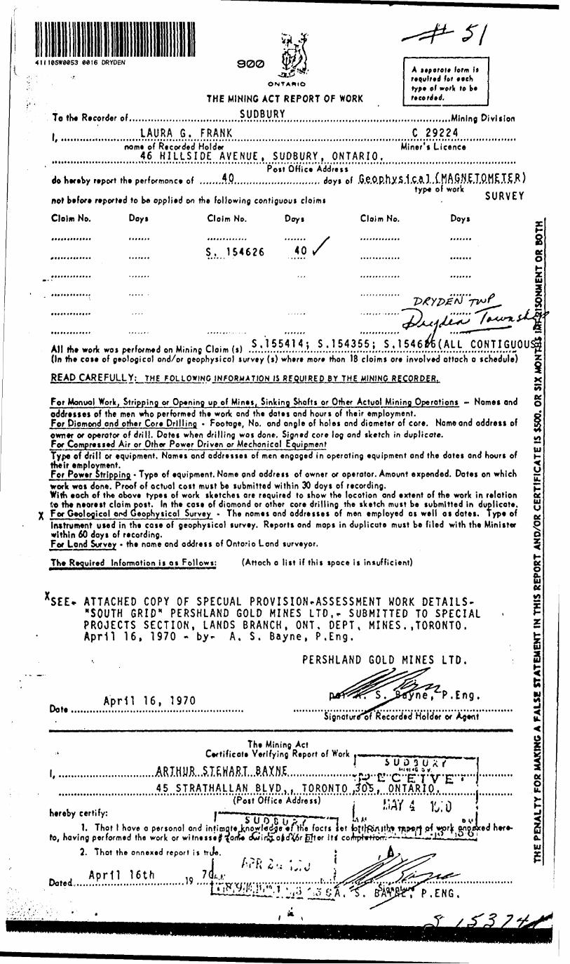
THE MINING ACT REPORT OF WORK
To the Recorder .1 .,..,,,,,,..,.,.,...,....?.y.R.BURY.,,,,,,,,,..,,,
, LAURA G, FRANK
A i*porei* form li required for eeeh typt of work to k* r* cord* d.
..............Mining DivisionC 29224
no m* of Recorded Holder Miner's Licence
M .o..M...................AO.lVk?.!.RL.^Post 6 Hi c e Address
do hereby report the performonce of .......r.P............................ doys oftype of work
not before reported to be opplied on the following contiguous cloims
Clolm No. Doys Claim No. Days
SURVEY
Claim No. Days
S. 154626 40zK O
i,,* j. t j u . - n -li S.155414; S.154355; S .1546frfc(ALL CONTIGUOU All the work wos performed on Mining Claim (s) ................../....................."....................A..........;;......,.;.;.(In the cose of geological and/or geophysical survey (s) where more than 18 cloims ore involved attach o schedule) z
READ CAREFULLY: THE FOLLOWING INFORMATION IS REQUIRED BY THE MINING RECORDER.
For Monuol Work, Stripping or Opening up of Mines, Sinking Shofts or Other Actual Mining Operotions - Nomes ondaddresses of the men who performed the work and the dates and hours of their employment.For Diamond ond other Core Drilling - Footoge, No. ond angle of holes ond diameter of core. Name ond address ofowner or operator of drill. Dates when drilling wos done. Signed core log ond sketch in duplicote.For Compressed Air or Other Power Driven or Mechonicol EquipmentType of drill or equipment, Nomes ond addresses of men engaged in operating equipment and the dates and hours oftheir employment.For Power Stripping - Type of equipment. Nome ond address of owner or operator. Amount expended. Dotes on whichwork was done. Proof of actual cost must be submitted within 30 doys of recording.With each of the above types of work sketches are required to show the location ond extent of the work in relationto the nearest claim post. In the case of diamond or other core drilling the sketch must be submitted in duplicote,Fer Geological ood Geophysical Survey - The nomes ond oddresses of men employed os well os dates. Type ofInstrument used in the case of geophysical survey. Reports ond mops in duplicate must be filed with the Ministerwithin 60 doys of recording.For Lend Survey - the name ond address of Ontario Lend surveyor.
The Required Information i i os Follows: (Attach o list if this space is insufficient)
ATTACHED COPY OF SPECUAL PROVISION.ASSESSMENT WORK DETAILS- "SOUTH GRID" PERSHLAND GOLD MINES LTD,- SUBMITTED TO SPECIAL PROJECTS SECTION, LANDS BRANCH, ONT. DEPT, MINES..TORONTO. April 16, 1970 - by- A, S. Bayne, P.Eng.
PERSHLAND GOLD MINES LTD.
April 16, 1970Dot*
, P.Eng.
Signotur^of Recorded Holder or Agent
The Mining Act Certificote Verifying Report of Work r
.....,...,...,,,^
hereby certify:(Post Office Address)
i.^^^
i'' i SUO&UP";—-i1. Thot l hove o personal ond intimate knowledge eOhe facts let
to, having performed the work or witneiiej ' n" *"'
2. Thot the a nnexed report i* trje.
. , April 16thDoted...................................
. j VM
AY 4 b! OD V l
r|c onpexed here-
'""\j^^'^tsENG
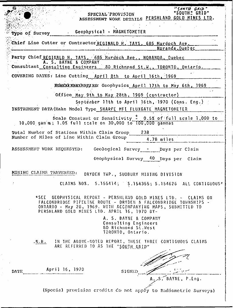
^ ' SPECIAL'PROVISION "SOUTH" ..... ^M^v'n- ' ASSESSMENT WORK DETAILS PERSHLAND GOLD JUNES LTD. i
^ Type of Survey____. Geophysical - MAGNETOMETER___________________ j
Line Cutter or Contractor'RCGINALD H. TAYS. 685 Murdoch A ve..Noranda .Quebec
f Party Chief.REGlHALD H. TAYS. 685 Murdoch Ave . . NORANDA. Quebec.^...^.^.^A. S. BAYNE S COMPANY
Consultant Consulting Engineers__80 Richmond St.W.. TORONTO. Ontario. --^
COVERING DATES: Line Cutting April 8th to April 16th. 1969 ^^..^.
WfiDBO)a)RBWCMOC9WX(Xr Geophysics April 17th to May 6th. 1969
Of f i ce May 9th to May 28th, 1969 (contractor)-.. .- . ..Septeinber nth to April 16th, 1970 (Cons. Eng.)
INSTRUMENT DATA (Make Model Type, SHARPE MFI FLUXGATE MAGNETOMETER_________
Scale Constant or Sensitivity^- Q.5% of-full sc-ale 1,000 to 10,000 gam'rs; 1.0^ full scale on 30,000 to fOO.OOO gTmmas
Total Number of Stations Within Claim Group 238Number of Miles of Line Within Claira Group 4 7ft Iles
ASSESSMENT WORK REQUESTED: Geological Survey __ ̂ ^ Days per Claim
Geophysical Survey 40 pays per Claim
DRYDE:N T WP-j S UDBURY H IHING DIVISION
CLAIMS NOS. S.1554H; S. 154355; S. 154626 ALL CONTIGUOUS^
*SEE GEOPHYSICAL REPORT - PERSHLAND GOLD MINES LTD. - CLAIMS ON FALCONBRIDGE PIPELINE ROUTE - DRYDEN R FALCONBRI [)GL TOWNSHIPS - ONTARIO - May 28, 1969. WITH ACCOMPANYING MAPS, SUBMITTED TO PERSHLAND GOLD MINES LTD. APRIL 16, 1970 BY-
A. S. BAYNE fc COMPANY Consulting Engineers 60 Richmond St. We s t TORONTO, Ontario.
H- B. IN THE ABOVE-NOTED REPORT, THESE THREE CONTIGUOUS CLAIMS ARE REFERRED TO AS THE "S.QHT1UUUP"
DATE AP ri1 1 6 ' 1 970
A. xS.' BAYNE, P. Eng.
(Special provision credits do not appl'y to Radiometric Surveys)

'.p- Type of Survey
. "NORTH- GRID" SPECIAL PROVISION PERSHLAND GOLD MINES LTD.
ASSESSMENT VJORK DETAILS
Geophysical -- MAGMETOMETER
^Chief Line Cutter or Contractor' REGINALD H. TAYS, 685 Murdoch Ave.Noranda , Quebec
Party Chief^
Consultant
REGINALD H. TAYS, 685 Murdoch Ave. t NORANDA, Quebec.
A. S. BAYNE i.COMPANY, Consulting EngT neers .
COVERING DATES: Line Cutting March 27th to March 31, 1969,
Field 88R180XX8X Geophysics^-
Office_____ May th to May 28th. 1969
April 1st to Mav 2. 1969
( Con t ra r. tnr
•'. ' Sept. 11,1969 to Apr/ 16,1970(Cons. Eng.) INSTRUMENT DATA(Make Model Type______SHARPE MFI FLUXGATE MAGNETOMETER
Scale Constant or Sensitivity -for- 0. 5JE of full sea le
3,000^to-10,000 gamma ranges; T.0% full scale on 30,000 to 100,000 gammas;Total Number of Stations Within Claim Group________245_____________.^ Number of Miles of Line Within Claim Group
S mil P* .,
ASSESSMENT WORK REQUESTED: Geological Survey Days per Claim
Geophysical Survey 40 Days per Claim
MINING CLAIMS TRAVERSED: FALCONBRIDGE TWP., SUDBURY MINING DIVISION
CLAIMS NOS.-- S. 153741; S.132976; S.15*051 ALL CONTIGUOUS*
* SEE GEOPHYSICAL REPORT - PERSHLAND GOLD MINES LIMITED -CLAIMS ON FALCONBRIDGE PIPE LINE ROUTE - DRYDEN S FALCONBRIDGE TOWNSHIPS - ONTARIO - May 28, 1969 . WITH ACCOMPANYING MA?S. SUBMITTED TO PERSHLAND GOLD MINES LTD. APRIL 16,1970 BY -
A. S. BAYNE S COMPANY Consulting Engineers 80 Richmond St.West TORONTO, Ontario.
N.B. IN THE ABOVE-NOTED REPORT, THESE THREE CONTIGUOUS CLAIMS ARE REFERRED TO AS THE "NORTH GRID"
DATE April 16, 1970 SIGNED
A. S.^BAYNE, P. Eng
(Special provision credits do not apply to Rndiomotric Surveys)

Req ed O i* ~n
is?
ytc*
."*'
** -c o
Q-
i* 3 J 2
o
nL
~ ii 2,
S ?
So
7
M-3 *
o
s.
o o 3-
0
1 L•*
X
o
**.
3"
S ?
2
,
^r : o
t^
^5
*3
!* a
.s-1
i*
olr
o- z
-40 S
-*
2-j
-g
a v
J a
o "
c2
3.2 f
3O
a
—.
OL.
3 2
* 3 J
** a-2
o. g
:o
3*S.
*
2LS
s *
2o r
t "^
ET
0.0
* 3
' o^
a M
o ^
" —
o 2
- 3
a —
* .9
a
•o o n
o g: 3
•J O
•o*
O
o
p;
O o LI
i? M j{ ~ ?*
o
H?
•h -n*
C
3
——
2 l" IS sg-
.
T}
OL
.3
oS
2-*
a
Q.
o
O
^^
O"c
TZ "
on 5
o
5 -a
. irS- a
r o c\
^"5.
i^ *
a o. a r
•3
x
^
S
sir
tO
L* J
r?
O
**-O
f
o 5"
S-
j' *
i i
3 3 3"
—
CL.
O
C3
T
LQ
. ~
^
O
O.
O
o * .1
3-
JO
2 'y 3
2
io 3
C
L.
O O.
O.f
•S*
* S
rr.
2T
"K
2,?S
-.
r.S
o
n
•s -
S J2
ro X \
TH
E P
EN
AL
TY
FO
R M
AKtM
G A
FA
LSE
STA
TEM
ENT
IN T
HIS
RE
POR
T .
AMD/
OR
CE
RT
IFIC
AT
E I
S S5
00.
OR
SIX
MO
NTH
S IM
PRIS
ON
MEN
T O
R B
OTH
o
"SOUTH GRID"
""SHLAND GOLD H.NES LTD
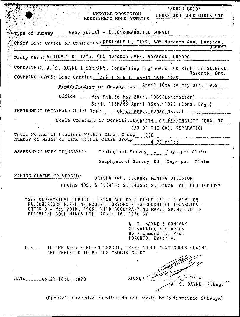
of Survey Geophysical - ELECTROMAGNETIC SURVEY _______________'fi' - :-.. ' " " ' ..-
S' Chief Line Cutter or Contractor' REGINALD H. TAYS , 685 Murdoch Ave. .Noranda ,'•^••:t- . Quebec•* ' -,
Party Chief REGINALD H. TAYS, 685 Murdoch Ave- , Noranda, Quebec ———-—-———
Consultant A.'S. SAYNE A COMPANY, Consulting Engineers, RQ Rirhmnnri. . Toronto, Ont.
COVERING DATES: Line Cutting April 3th to April 16th ,T 969 ̂ ^^......^...
V* Geophysics APH1 th to May 8th, 1969
Office Hav 9th to May 28th. 1969f Contractor) .———— Sept. llth}?6 9 April .16th, 1970 (Cons. Eng.)
INSTRUMENT DATA (Make Model Type HUNTEC MODEL RONKA MK . 1 1 1 _ _____ - -
; Scale Constant or Sensitivity DEPTH OF PENETRATION EQUAL TO'.2/3 OF THE COI.L SEPARATION
Total Number of Stations Within Claim Group 2 38 ________ ___ ___ ̂M—— Number of Miles of Line Within Claim Group 4.78 miles
ASSESSMENT WORK REQUESTED: Geological Survey - Days per Claim
Geophysical Survey 20 Days per Claim
DRYDEN T wp ̂ ^W M INING DIVISION
CLAIMS NOS. S. 155414; S. 154355; S. 154626 ALL CONTIGUOUS*
*SEE GEOPHYSICAL REPORT - PERSHLAND GOLD MINES LTD.- CLAIMS ON FALCONBRIDGE PIPELINE ROUTE - DRYDEN S FALCONBRIDGE TOWNSHIPS - ONTARIO - May 28th, 1969. WITH ACCOMPANYING MAPS, SUBMITTED TO PERSHLAND GOLD MINES LTD. APRIL 16, 1970 BY-
A. S. BAYNE S COMPANY Consulting Engineers 80 Richmond St. West TORONTO, Ontario.
!LJb— I N THE ABOV E-NOTED REPORT, THESE THREE CONTIGUOUS CLAIMS ARE REFERRED TO AS THE "SOUTH GRID"
SIGNED.-'S. BAYNE. P.Eng.
^^Z'"'
(Special provision credits do not apply to Rciclioinctric Surveys)

SPECIAL PROVISION .."NORTH GRID" ASSESSMENT WORK DETAILS
PERSHLANDGOLD MINES LTD.
Type of Survey ____ - Geof ,, sical - ELECTROMAGNETIC survey
Line Cutter or Contractor'KEGIHALD H. TAYS, 685 MuVdoch Ave . .NORAIIDA .
Party Chief REGINALD H. TAYS > 685 Murdoch Ave . . Noranda , Quebec
Consultant A. S. BAYNE fl COMPANY, ConsuUIng Engineers, 80 Richmond St. West- Toronto, Ontario.
COVERING DATES: Line Cutting March 27th to March 31st f '1969 ̂ ^^^^....
Field Geology or Geophysics April 1st to May 5th , 1969 ——Way 9th to May 28th, 1969 (Contractor)'Office
Septi lith, 1196?. to". April 16, 1970 (Cons. Eng.)INSTRUMENT DATA (Make Model Type HUNTEC MODEL RONKA MK.III ̂^^^.^^^^^^^
Scale Constant or Sensitivity DEPTH OF PENETRATION EQUAL TO; 2/3 OF THE COIL SEPARATION
Total Number of Stations Within Claim Group 245 ______ _ -——.————m——Number of Miles of Line Within Claim Group c -i1 5 mi l es
ASSESSMENT WORK REQUESTED: Geological Survey _____ Days per Claim
Geophysical Survey _ 20 __ Days per Claim
MINING CLAIMS TRAVERSED: FALCONBRIDGE TOWNSHIP, SUDBURY MINING DIVISION
CLAIMS NOS.-- S. 153741, S. 132976; S. 155051 ALL CONTIGUOUS*
*SEE GEOPHYSICAL REPORT - PERSHLAND GOLD MINES LIMITED - CLAIMS ON FALCONBRIDGE PIPE LINE ROUTE - DRYDEN b F ALCONBRIDGE TOWNSHIPS - ONTARIO - fjay 28, 1969. - by R. H. Tays. WITH ACCOMPANYING
MAPS SUBMITTED TO PERSHLAND GOLD MINES LIMITED APRIL 16, 1970 BY-
A. S. BAYNE l C OMPANY Consulting Engineers 80 Richmond St. West TORONTO, Ontario.
N.B. IN THE ABOVE-NOTED REPORT, THESE THREE CONTIGUOUS CLAIMS ARE REFERRED TO AS THE "NORTH GRID"
April 16, 1970 DATE SIGNED
A. SX^AYNE, p.Eng.(Special provision credits; do not apply to lUidiomctric Surveys)

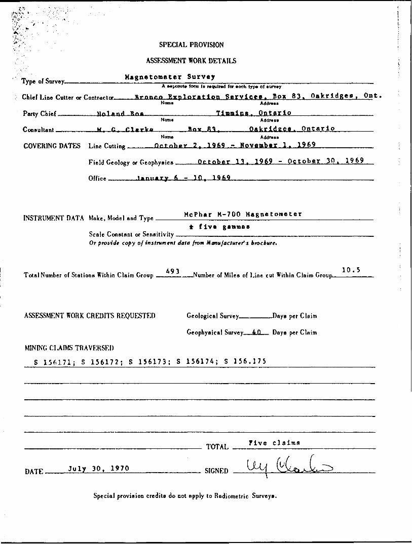
SPECIAL PROVISION
ASSESSMENT WORK DETAILS
Type of Survey. Magnetoaater Survey
Chief Line Cutter or Contractor.A •aporato form U required lor *och lyp* of
Bronco Exploration Service*, Box 83, Oakridges, Ont
Party Chief. Noland BoaNorn* Address
Tinmina, Ontario
Consultant, M. G. ClarkeNmn*
Box 83Address
Oakridgas, Ontario
COVERING DATES Line Cutting
Field VMJMg? or Geophysics
Office ——
Sept*"6"r 2, 1969 - October*1?',' 1969
September 20, 1969 - October 10 f 1969
Jannary ft t 10.70 - January 10, 1Q7Q————..——.——-——.
INSTRUMF:NT DATA Meke, Model and Type.. McPhar M-700 Magnetometer
i S gaanaaScale Constant or SensitivityOf providt copy of instrument data from Manufacturer's brochure.
Total Number of Stations Within Claim Group 504 -Number of Miles of Line cut Within Claim Group- 10.75
ASSESSMENT WORK CREDITS REQUESTED
MINING CLAIMS TRAVERSED
Geological Survey. -Days per Claim
Geophysical Survey—&Q Days per Claim
S 156166; S 156167; S 156168; S 156169; S 156170
DATE.July 30, 1970
TOTAL Five claims
SIGNED __. LjtSpecial provision credits do not apply to Radiometric Surveys.
Type of Survey-
SPECIAL PROVISION
ASSESSMENT WORK DETAILS
Magnetometer SurveyA Mpara t* form l i required (or *och lyp* of *unr*y
Chief Line Cutter or Contractor____Krnnea Exploration S ervices. B ox 83. Oakridgea, Ont,Norn*
Party Chief l *,r\A R naAddr***
Timmins OntarioNero*
Consultant GAddr*s*
OakridCS. OntarioNorn* Addrcsi
COVERING DATES Line Cutting Orfnhar 2 1969 - Movenber 1. 1969
Field Geology or Geophysics
Office ______ iftniiMry
October 1 3, - October 30. 1969
- 10
DATA Make, Model and Type McPhar M-700 Magnetometer
* five gammasScale Constant or Sensitivity —————-———.————™-—— Or provide copy of instrument data from Manufacturer1 s brockure.
Total Number of Station B Within Claim Group ————————Number of Miles of Line cut Within Claim Group——————
Geological Survey Days per ClaimASSESSMENT WORK CREDITS REQUESTED
Geophysical Survey. 4 O — Days per Claim
MINING CLAIMS TRAVERSED
S 156171; S 156172; S 156173; S 156174; S 156.175
PATE July 30, 1970
TOTAL
SIGNED
Mvc c laltnfl
Special provision credits do not apply to Radiometric Surveys.

J/
SPECIAL PROVISION
ASSESSMENT WORK DETAILS
Type of Survey_______Electro Magnetic SurveyA separate form l* required for *och typ* ol survey
Bronco Exploration Service* Box 63 Oakrldges, OiChief Line Cutter or Contractor.Nome Addres*
Party Chief ______ Boland POP ______________ Tiaaina, OntarioNorn* Addr***
Consultant . .-—————- M 4 P. C lark* _________ Ho* ^ "\ , O ofcridgaa, Ontario ————.———.Name Address
COVERING DATES l -i"* f...nioe <;> ^ ^> B.r. 0 r ?, IQKO . Ortob^y 2 t 1969 —-——--.,-.
Field GgtKht&xor Geophysics ____ Qptnbar ?, 19fi9 -October 10^ 1969
Office ____ January 6 - 10, 1970 -—-—-——————————---—————-
INSTRUMENT DATA Make, Model and Type ______Cron* Raden VLF
Scale Constant or Sensitivity 1/2 degreeOr provide copy of instrument data from Manufacturer's brochure.
Total Number of Stations Within Claim Group ________Number of Miles of Line cut Within Cluim Group_____*
ASSESSMENT WORK CREDITS REQUESTED Geological Survey_______Day* per Claim
Geophysical Survey——2D— Days per Claim
MINING CLAIMS TRAVERSED
S 156160; S 1561578; S 156168; S 156169; S 156170
TOTAL F ive c laims
DvrF July 30. 1970 __________ SIGNED ^M
Special provision credits do not apply to Radiometric Surveys.

Type of Survey
SPECIAL PROVISION
ASSESSMENT WORK DETAILS
Maftne tie Survav_______A ••porate iortn (t required (or *och typ* of survey
~.. t, . ^ - Bronco Exploration Service*, B ox 83, Onkridgei, Ont.Chiel Line Cutter or Contractor_____________I__________________________________________
Norn* Addrat*
Party Chief
Consultant
Noland Boa Tiaraina OntarioNom*
filar kaAddr*u
Oakridaa OntarioNome
COVERING DATES Line r..t.ine 2Addrx*
- Novambar l ~ 1969
Field Geology or Geophysics ____ October 26 1 1 969 - November 3. 1969
Office _____ January fe. 197Q - January 10, 1970 ——..———————--
INSTRUMENT DATA Make, Model and Type Crone Radtm VLF
Scale Constant or Sensitivity —Or provide copy of instrument data from Manufacturer's brochure.
Total Number of Stations Within Claim Group A93———Number of Miles of Line cut Within Claim Group-——lfL-JL
ASSESSMENT WORK CREDITS REQUESTED Geological Survey
Geophysical Survey
Days per Claim
Days per Claim
MINING CLAIMS TRAVERSED
S 156171; S 156172; S 156173; S 156174; S 156175
DATE July 30, 1970
TOTAL
SIGNED
Five c laims
\Jj
Special provision credits do not apply to Radiometric Surveys.

DEPARTMENT OF MINESPROJECTS. tECTION
THE MINING ACT
Assessment Work Credits FILE: .
DATE:.
6 3.1. ' lr.'i
Name.
Township or Area: ..........-.^^:L..:-....;lJ.X.;.lX!::ZL_____^T-
Type of Survey and Number of Assessment Days Credits per Claim Mining Claims
GEOPHYSICALI J Special Provision
II Ground
Magnetometer
Electromagnetic
x nnI j Airborne
......'i__ days
__X_M days
._.___..days
GEOLOGICAL
i l Special Provision
.______days
j j Man days
RADIOMETRIC
j_l Ground
.—__—days
j i Airborne
GEOCHEMICAL
D Notice of Intent to be issued (credits have been reduced because of insuf ficient or partial coverage of claims)
No assessment credits have been allowed for the following mining claims as they were not sufficiently covered by the survey______________...
r-*
re ('T/;.- err-':-; t for Puch t-f
S i SS^/V, t l 5"^ d
go^0 Hiriyr. credit fer minim: c I ti i r
The Mining Recorder may reduce the above credits if necessary in order that the total number of approved assessment Jays recorded on each claim does not exceed the maximum allowed as fnlloirx:
of
,..l. -V* .

WHITNEY BLOCK.QUEEN S PARK.
TORONTO 182. ONT
DEPARTMENT OF MINES AND NORTHERN AFFAIRSU1NINO LANDS BRANCH ftj.2776
t 1970.
Mr. K. H. Mlnittf Kacordtr, 118 C*d*r Str**t, BikJbury, Ontario.
D*ar Sir J
R* t Nininf C l* l* Ho. S 1S37*1 *t al, t raloonbridf*
Th* 0*ephy*ioal Assetsmwnt vork credit* as tkown on tha attaohad list hava baan approved aa of tha da\a abt t. Plaaaa infora tha raoordad holdar and so iodioata on your ra cord*.
Toura vary truly,
/df.
frad V. Hatthawa,Suparriaor.
Project* Section.
e.e. Farahland Cold Mioat, **20 - 1S9 Bay St., Toronto, Ontario,
c.o. Raaidant Oaelogiat, 1MI U (alia Bird., Sudbury, Ontario.
Folconbridge Twp.Get i-
ft ® h'l
THE TOWNSHIP "• ?"
OF
DRYDENDISTRICT Of
SUDBURY
SUDBURY MINING D IVISION
SCALE:MNC^4O CHAINS

-a aQ)O

"™± — L aa*- ram KUM. .BBJ?, am-THE TOWNSHIP M
FTO5RMDGEDISTRICT OF , -SUDBURY
SUDBURY MINING DIVISION
•'^ ' SCALE:lilNCH^4O CHAINSA*
' K ' l )*MM ^ l r
•'/-.T .?^ ,,,1.. 1MIM

IbENlT/F/eb
•r, ' -'
LOCATE b in "foe/w THE (.x)

Jo V-P
N'P
^?
OV-OC2H
Iinvu
K\
1X
t-^-f^.f;'-
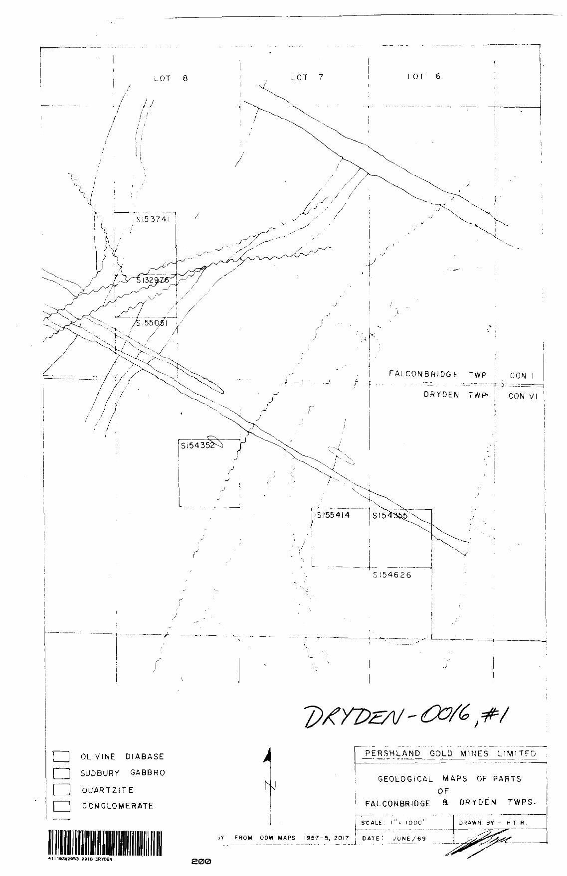
LOT 8 LOT 7 LOT 6
FALCONBRIDGE TWP
DRYDEN TWP-
CON l
CON VI
SIS
S154626
OLIVINE DIABASE
SUDBURY GABBRO
QUARTZITE
CONGLOMERATE
PERSHLAND GOLD MINES LIMlTFD
GEOLOGICAL MAPS OF PARTS
OF FALCONBRIDGE ft DRYDEN T WPS-
SCALE i l " ' l OOC'
FROM ODM MAPS 1957-5,2017 DATE! J UNE/69
•41lieSWWS3 0016 DRYDEN 200
DRAWN BY - H T R

LEGEND-F*|Ct*E-T r 1. 1 l
"*. *.
OOo
i^ n /VjKJt-T i L k? i- -v D i
J3 o h-0
MAGNETOMETER SURVEY
PERSHLAND GOLD MINES LIMITEDCLAIM S-8-153741^5-132976^8-155051
FALCONBRIDGE TWR^DISTRICT OF SUDBURYONTARIO
'V' *U)' sw*UQRTM GRIP
41IUSWHI53 0016 DRYDEN 210

'l -t f'/- ft C ",J ' t /
PERSHLAND GOL5 MINES LIMITED
Mt i QMi l l K' i
PAR l O C i A l M i' ./l 50.:N l vOI?^ni'ol kH l Of
eeie DRYDEN 220

LOT 7 LOT Q
N
— C "i-. A.i*-1-p PICKET iint.PKniistvi.ev lo*
MAGNETOMETER S URVEY
PERSHLAND GOLD MINES LIMITEDCI A IMS-lSa*l*~ I 5435S ~* \5AG2G
M TWP. -^ DISTRICT or SUDBURY
SOUTW
e* 16 DRYDEN 230

M\\4 ^O;w
RONKA W.L.E.M SURVEY
PERSHLAND GOLD MINES LIMITEDCL Al M S-S 1537^1^6 I3297G *,S-IS6O5i
FALCONBRIDGE ^ DISTRICT OF SUDBURYON TAR J O
ZGCs S 00
-00/6.. KJQRTM GRID
41 l I0SWUK.53 0016 DRYDEN

I I., (.f N1J)
r/11 7 s ,-
>
\
\
LOT 7
Ot OQ
CE.kJTE.'R
PERSHLAND GOLD MINES LIMITED
R?QKJKA L o M K- v t . , y4 5 "O M PAR T O l C' t AIM
r* H VIM M TVOP^DI'.il k U l O \ S i i p 131' KJ Y
O M T AU. l O
I s ' l y*.y
4MieSWM53 0016 DRYDEN eso

N
tf A
^ \ .-'r^ \ ;~ '''^ \ ̂ . l
pit Kt-T 1.1 ML PL -. tTi, t,vM? ^ i od f i f t
'- , \0 \ , 'f . T
RQMKA KU..&.M. SURVEY
PERSHLAND GOLD MINES LIMITED^ ^54355 ^
N/l
COM
DRVPE.M Tv^p. -v DISTRICT OP SUDRURY
SOUTH GRID
41 IHSS*f**53 0016 DRYDEN B60