mrc water utilisation programme 20 may 2003 knowledge base & dsf software presenter: dr jon...
TRANSCRIPT

MRC Water Utilisation Programme
20 May 2003
Knowledge Base &
DSF Software
Presenter: Dr Jon Wicks,Software Integration Specialist
in association with WRCS, Water Studies, FEl, EIA, and Team Consultants, CamConsult, Laos Consulting
Services,Water Resources University of Hanoi

Contents
• Requirements
• Top Level Design
• Knowledge Base
• DSF User Interface and Tools
• Proposed Documentation

Requirements – The Need
• Planning tool to:– test development scenarios and assess
impacts on environment and socio-economics
– assist in rules development

Requirements – Detailed
• Captured from:– terms of reference– working papers– workshops/other discussions– feedback on interim DSF releases

Top Level Design
Knowledge Base
Planning and monitoring data such as:
• hydrological records
• physical data • socio-economic and environmental data • scenario description data• simulation model input data• simulation model results
MRC Decision Support Framework (DSF)
DSF User Interface and Tools
Basin Simulation Modelling Package SWATSWAT
IQQMIQQM
ISISISIS
Impact Analysis Tools
Reporting Tools

Top Level Design
• Four categories of user:– Managers/planners– DSF Operators– Specialist Modellers– System Administrators

Modeller
KB
Line Agency
LAN
Operator/ModellerPlanner
KB
NMC 1
LAN
OperatorPlanner
KB
NMC 3
LAN
Operator/ModellerPlanner
KB
NMC 2
LAN
Operator/ModellerPlanner
KB
NMC 4
LAN
Operator ModellerPlanner
Master KB
MRCS
Modeller
KB
Line Agency
LAN
Operator/ModellerPlanner
KB
NMC 1
LAN
OperatorPlanner
KB
NMC 3
LAN
Operator/ModellerPlanner
KB
NMC 2
LAN
Operator/ModellerPlanner
KB
NMC 4
LAN
Operator ModellerPlanner
Master KB
MRCS
Distributed System

Knowledge Base
• Stores data such as:– hydrological records– physical data – socio-economic environmental data– scenario description data– simulation model input data– simulation model results
• Data categorised into:– Times series– GIS data sets– Model simulation data sets– Miscellaneous data
Knowledge
Base
MRC DSFDSF GUI / Tools
SWATSWAT
IQQMIQQM
ISISISIS
Impacts
Reports

Knowledge Base – Data contents
• Early 2003:– 51 layers of spatial data– 800 time series records
• Further data continues to be added as verified during modelling process

DSF User Interface & Tools
• Single user-friendly interface to:– Scenario management (define, review)– Simulation models (edit, run)– Impact analysis tools (time series, spatial)– Reporting tools (maps, tables, graphs)– Administrator functionality
Knowledge
Base
MRC DSFDSF GUI / Tools
SWATSWAT
IQQMIQQM
ISISISIS
Impacts
Reports

Tool barTool bar
Title barTitle bar
Menu barMenu bar
Status barStatus bar
Overview mapOverview map
Main mapMain map
LegendLegend
Tool barTool bar
Title barTitle bar
Menu barMenu bar
Status barStatus bar
Overview mapOverview map
Main mapMain map
LegendLegend

Scenario Management
• 3 components:– Climate– System demands– Proposed
interventions
• Defined by manager/planner

Scenario Management
• Operator/modeller selects models (or builds models) to represent the scenario
• Editing of model data sets may be required

Editing Model Datasets
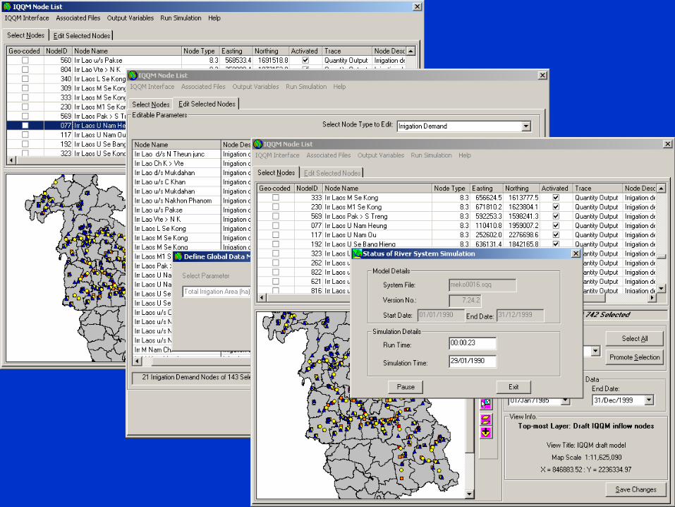
• New custom-built users interface within DSF for:– SWAT (hydrometeorological time series)– IQQM (selected data)– ISIS (boundary conditions)
• Edit, run models, accept results
Knowledge
Base
MRC DSFDSF GUI / Tools
SWATSWAT
IQQMIQQM
ISISISIS
Impacts
Reports

DSF–SWAT Interface

DSF–IQQM Interface
• Enables ‘operator’ to edit:– Hydrometeorological time series– Irrigation nodes (max areas, cropping)– Flow control nodes (demand flows)– Fixed demand nodes (demand flows)– On-river storage nodes (power station
efficiencies)

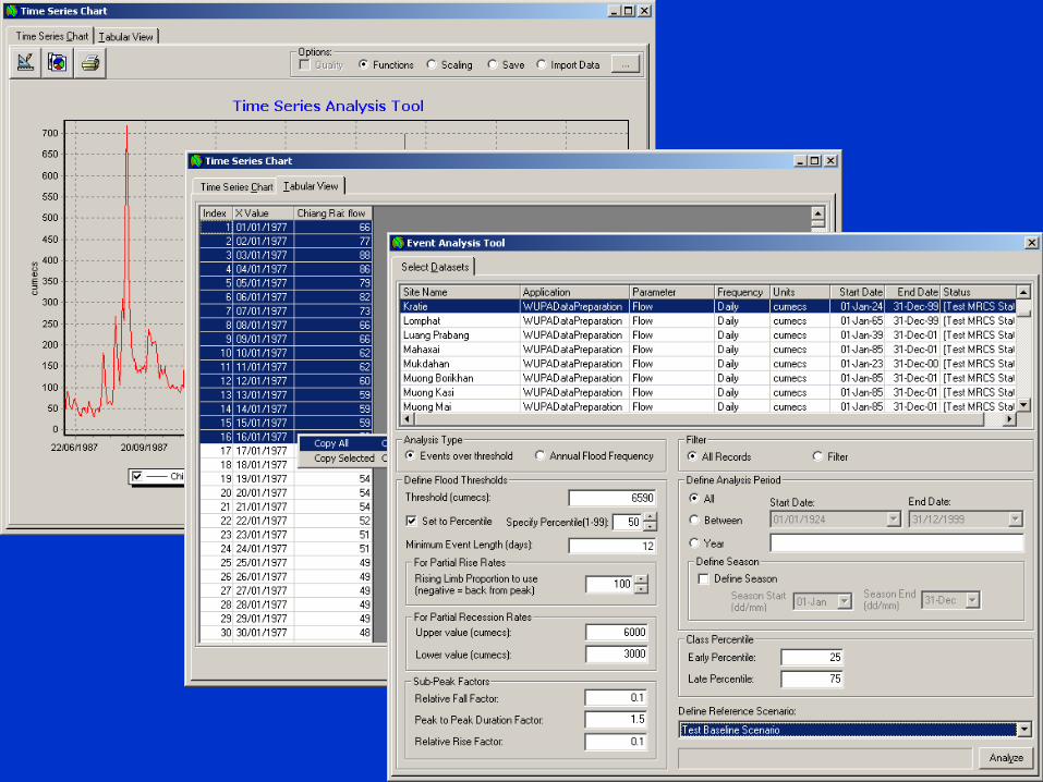
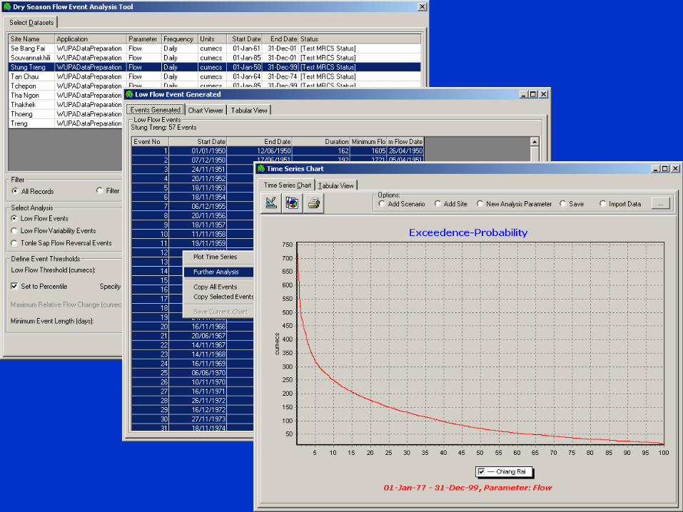
Impact Analysis Tools
• Time Series Tools:– Time series plotting– Flood event analysis– Low flow analysis (including Tonle Sap flow
reversal)– Probability-exceedence
Knowledge
Base
MRC DSFDSF GUI / Tools
SWATSWAT
IQQMIQQM
ISISISIS
Impacts
Reports

Impact Analysis Tools – Spatial
• Post-processing of hydraulics/salinity: – Flood extent– Flood depth– Flood duration– Maximum salinity (grid and contours)– Maps of duration thresholds exceeded (eg months
higher than 1g/l, 4g/l)
• Reported on grid or by ‘planning area’• For area downstream of Kratie including
Tonle Sap

Reporting Tools
• Tools aimed at planner/manager user:– Text and tabular results (eg time series
statistics)– Graphs (using Impact Analysis Tools ‘time
series plotter’)– Maps (either from DSF GIS-type view or
ArcView format files in external GIS)
Knowledge
Base
MRC DSFDSF GUI / Tools
SWATSWAT
IQQMIQQM
ISISISIS
Impacts
Reports

Proposed DSF Documentation
DSF Brochure – ‘What the DSF can do’ : 6 page summary of capabilities
DSF User Guide – ‘How to do it’: 100 page user guide / software manual for manager/planner and operator. Key reference source for most users.
Simulation Software Manuals: Standard user manuals for SWAT, IQQM and ISIS (digital)
Knowledge Base Data Catalogue – ‘What data are in the KB’: Catalogue of the data stored in the Knowledge Base. First version will define data holdings in KB at end of Halcrow project. (digital?)
DSF Training Material: Training notes and PowerPoint presentations for use during training.
Reference Reports - ‘Background information for all’ : revised versions of working papers 13-15
DSF Software Documentation - ‘For future programmers use’
Final Report - Administrative report covering process and outcomes of WUP-A project

Remarks
• DSF design has evolved following workshops, discussions and feedback
• Expect further refinement during ‘scenario testing’ and during further training and future use

Thank you and any questions