mountains of the world: water towers for the 21st century
TRANSCRIPT

Mountains of the World:Water Towers for the 21st Century
Foreword 3
Rationale 4
Why focus on mountain waters? 5
Case studies from Africa and the Middle East 8
The Nile Basin: an international challenge to mountain water management 8Mount Kenya: a vital water tower in a semi-arid region 10The Jordan River Basin and the West Bank aquifer: sharing mountain water resourcesin a politically sensitive arena 12
Case studies from Central Asia and Europe 13
The Aral Sea Basin: overuse of mountain water resources 13The Alps: the water tower of Europe 14
Freshwater contributions from mountains: A global view 16
Case studies from Asia 20
The Indus River: mountain water for the world’s largest irrigation network 20The Himalaya: responsible for floods from local to continental scale? 21The Mekong Basin: managing the pressures of rapid economic development 22
Case studies from the Americas and Oceania 24
Glaciers in the tropical Andes: a life-line during the dry season 24Andean water: supply for the world’s largest copper mines in Chile 25The Fraser River of the Rocky Mountains: a highly productive ecosystem for salmonids 26The Southern Alps of New Zealand: water for electricity generation 27
Mountain waters: challenges for the 21st century 28

2 Water Towers for the 21st Century

3Foreword
Water is life. It is essential for all aspects of ourlivelihood, from basic drinking water to foodproduction and health, from energy produc-tion to industrial development, from sustain-able management of natural resources to con-servation of the environment. Water is also avital part of our religious and cultural values.
Unfortunately, water is becoming scarce inmany areas and regions of our planet. Thelatest data from the World Water Council’sReport on Sustaining Water show clearly howalarming the situation is. The report calls forimmediate and effective action in order tomaintain freshwater availability in the comingcentury. This is an endeavour of global pro-portions – a challenge which must be con-fronted by the whole of humankind.
In Mountains of the World, our contribution tothe Commission on Sustainable Developmentand to the special session of the UN GeneralAssembly in 1997, Rio Plus Five, we brieflyshowed the vital, global role mountains playin supplying water and in regulating riverflows. This report also revealed the linkagesbetween upstream and downstream develop-ments.
The present publication, Mountains of theWorld: Water Towers for the 21st Century, elabo-rates further on the interrelationship betweenmountains and fresh water. Although manyin-depth hydrological studies have been car-ried out, a global overview of the contributionmountains make to the supply of water to
humankind has been notably absent. Thispublication presents a compilation of casestudies, together with an overview of the im-portant role of mountains in supplying freshwater to the world, and a summary of themain challenges to be faced in maintainingthese water towers for the 21st century.
This report is a small contribution to Chap-ter 13 on mountains, and Chapter 18 onwater in Agenda 21. It is intended to create abetter understanding of the linkages betweenwater and mountains and to foster the needfor recognition of the important role moun-tains play in the water cycle. It highlights thenecessity of strong stewardship by mountainpopulations as well as the responsibility ofdownstream communities and nations for thesustainable management of mountain waterresources.
In addition, we sincerely hope that this reportwill promote the necessary initiatives and ac-tions required to sustain water availability inthe next century and to maintain and en-hance the role of mountains as water towersfor humanity.
Walter Fust
Director of theSwiss Agency for Developmentand Cooperation
Foreword
4 Water Towers for the 21st Century
Several research programmes on mountainecosystems were initiated in the 1970s, includ-ing UNESCO’s MAB project No. 6, Impact ofHuman Activities on Mountain Ecosystems in 1973,and the UNU’s programme on Highland-Low-land Interactive Systems in 1978. This was fol-lowed, in 1981, by the founding of the Inter-national Mountain Society, which producesthe scientific periodical Mountain Research andDevelopment. In 1992, during the UNCEDEarth Summit in Rio de Janeiro, the world’smountains finally received some attention atthe highest level. This was expressed formallywith the inclusion of Chapter 13 in Agenda21: “Managing Fragile Ecosystems – Sustain-able Mountain Development.”
After 1992, the UN Commission on Sustain-able Development appointed the FAO as taskmanager for the mountain chapter. Throughan unprecedented level of collaborationamong UN agencies, national governments,international organizations, NGOs and re-search institutions – again with the support ofthe Swiss Agency for Development and Coop-eration – a comprehensive report, Mountains ofthe World: A Global Priority, and a companionpolicy document, Mountains of the World: Chal-lenges for the 21st Century, were presented to thespecial session of the UN General Assembly,
Rationale
Rio Plus Five, in 1997. In all these documentsit was made very clear that mountains aswater towers for humankind must receivehighest priority in the 21st century and begiven serious consideration by the Commis-sion on Sustainable Development at its spring1998 session on “Strategic Approaches toFreshwater Management”.
The present document highlights the currentand future importance of mountains in globalfreshwater supply. It is a contribution to thediscussion on the role of mountains in theworld. Due to a shortage of data from moun-tain regions, no global quantitative assess-ment is possible. However, case studies havebeen collected from different parts of theglobe for this report, which presents a firstglobal overview in the form of an illustratedmap. In conclusion, the report highlights thechallenges to be faced in maintaining the roleof mountains as water towers.
Mountains of the World: Water Towers for the21st Century is an initial global assessment ofmountain freshwater resources. It aims to cre-ate the scientific interest and the increasedpolitical awareness necessary as a basis forconcrete measures to promote sustainablemanagement of mountain water resources.
Mountain water –a source of life.(Photo: H.P. Liniger)

5Why focus on mountain waters?
There are many reasons why we need to focuson mountains. The most important are:
High precipitation levels
Mountains form a barrier to incoming airmasses. Forced to rise, the air cools and precip-itation is triggered. This phenomenon is knownas the orographic effect. Rainfall thus generallyincreases with altitude (from 5 mm/100 m to750 mm/100 m elevation, depending on theclimatic zone), reaching maximum values be-tween 1500 and 4000 m altitude. In semi-aridand arid regions, mountains are the only areaswith sufficient precipitation to generate runoffand groundwater recharge. Colder tempera-tures at higher altitudes result in lower evapo-transpiration rates so that the overall waterbalance in the mountains is positive. In thesurrounding lowlands, with less precipitationand high evapotranspiration rates, the waterbalance is frequently negative. This imbalanceis smoothed by rivers connecting the highlandswith the lowlands.
Storage and distribution of waterto the lowlands
Mountain waters captured at high altitudesare carried under gravity via the stream net-work or groundwater aquifers to the lowlands,where the water demand from populationcentres, agriculture and industry is high. Thedistance covered can be hundreds to thou-sands of kilometres. Thus mountains natural-ly help to distribute water resources in space.In humid areas, the proportion of water gen-erated in the mountains can comprise as
Why focuson mountain waters?All the major rivers in the world have their headwaters in mountains.More than half of humanity relies on the fresh water that accumulates inmountains – for drinking, domestic use, irrigation, hydropower, industryand transportation. Mountain areas constitute a relatively small propor-tion of river basins, yet they provide the greater part of the river flowsdownstream. These “water towers” are crucial to the welfare of human-kind. As demand increases, the potential for conflict over the use ofmountain water grows. Careful management of mountain water resourcesmust therefore become a global priority in a world moving towards awater crisis in the next century.
much as 60% of the total fresh water availablein the watershed, while in semi-arid and aridareas, this proportion is much higher (up to95%).With high elevation and cold temperatures,mountains have the capacity to store precip-itation in solid form as snow and ice. Duringthe summer or dry season, when tempera-tures rise, meltwater is released precisely atthe time when precipitation is at a minimumand water demand, particularly for irrigation,is at a maximum. Therefore, the perennialflow of lowland rivers resulting from suchseasonally delayed meltwater releases is indis-pensable. Although ice and snow in tropical,subtropical and mid-latitude mountains store
Mt. Parinacota and LagunaChungará in the ChileanAndes.(Photo: M. Grosjean)
5
The Fedchenko Glacier inthe Pamir Mountains pro-vides water for irrigationin the Aral Sea Basin.(Photo: B. Messerli)
High Atlas, Morocco.Mountain waters fromglaciers irrigate the semi-arid valleys downstream.(Photo: B. Messerli)
only 1% of the global freshwater resources(polar ice sheets store about 70%), this supplyis vital because of its proximity to the areas ofwater demand. Mountains also store water inlakes and recharge groundwater bodies, sim-ilarly supporting lowland rivers in the dryseason through delayed flow. Mountains thushelp to distribute water not only in space, butalso at the right time.
The life-sustaining role of water towers
Clean water is fundamental to human exis-tence and health. Growing populations, in-tensifying agriculture and increasing urbani-zation and industrialization are leading togreater demands for water. Since 1940, globalfreshwater abstractions have more than quad-rupled. Clean mountain water plays a majorrole in satisfying these growing demands. Insome regions, however, the current demandfor high-quality fresh water is already greaterthan existing supplies. If water resource devel-opment is restricted, a thorough managementof demand (e.g. better water use efficiency) isrequired in order to avoid potential conflictsover the allocation of water between differentusers.With 70% of total freshwater abstractionsbeing made for irrigation, the dependency ofworld food production on mountain waters isevident. This is particularly important in thearid and semi-arid, monsoon (summer precip-itation) and Mediterranean (winter precipita-tion) climates of the tropics and subtropics,where most of the developing countries andmore than half of the world’s population arelocated.Water stored in mountain lakes and reservoirshas further economic value, given its potentialas a source of hydroelectric power that canprovide opportunities for the production ofenergy in a rapidly growing urbanized andindustrialized world.
6 Water Towers for the 21st Century

The Kikuyu and Masaipeople living in the MountKenya area hold the tradi-tional belief that Godresides on the peaks ofMount Kenya, the sacredmountain of brightness.Special ceremonies wereperformed to ask the godNgai for rain.(Photo: H.P. Liniger)
Mountain fresh water also sustains manynatural habitats, both in the mountains andthe lowlands, thus contributing to the con-servation of biodiversity. Mountain parksand protected areas not only support thepreservation of these habitats and their bio-diversity, but also safeguard natural, undis-turbed headwater catchments and thus theprovision of clean, dependable water sup-plies.
Fragile ecosystems
Mountains are highly fragile ecosystems.High rainfall, steep slopes, and erodible soilscan induce high surface runoff, soil erosion,and landslides. High-velocity rivers in head-water catchments can carry large amounts ofsediment and deposit them downstream.Eroded sediments are the major pollutant ofsurface waters. Deforestation of mountainwoodland, land use change, mining, con-struction of infrastructure, agriculture, andtourist activities in mountain areas may sig-nificantly affect the quantity and quality ofriver water. These human activities may in-crease surface runoff and lead to acceleratedsoil erosion and floods. Thus, careful man-agement of the mountainous part of water-sheds must have highest priority with regardto global freshwater resources.
Conflicts over water
Mountains deliver water to wide areas in thesurrounding lowlands, where it often has to beshared between many communities or, in thelarger basins, different countries. World-wide,214 river basins, host to 40% of the world’spopulation and covering more than 50% ofthe Earth’s land surface, are shared by two ormore countries. Transboundary water flowscan create political tensions, as exemplified bythe Nile, Jordan, Euphrates and Ganges riv-ers. The distribution of water from mountainswas the cause of 14 international conflictsover water resources noted in 1995. Conflictsover water can also arise at a smaller scale,between regions or highlands and lowlandswithin national boundaries.
“Sacred water”
People throughout the world have alwayslooked to mountains as the source of water,life, fertility, and general well-being. Moun-
tains have been, and in some places still are,worshipped as the home of weather deitiesand as the source of clouds and rain that feedssprings, rivers and lakes on which societiesmay depend for their very existence. For ex-ample, in times of drought, the Kikuyu peoplefaced Mount Kenya and asked the god Ngaifor rain, while in China, villages traditionallyhad a temple dedicated to the local mountaindeity responsible for clouds and rain.
Inadequate resource management
In general, mountains to date have beentreated as a resource to be used with littlerestriction. There has been inadequate hydro-logical monitoring and poor dissemination ofthe little data that do exist. This, together withan inadequate knowledge of mountain hy-drology, insufficient consideration of high-land-lowland interactions, and poor or lack-ing basin water resource management, canresult in serious degradation of water quantityand quality. There is thus a great need toimprove the current monitoring and manage-ment of mountain water resources.
It is estimated that in theyear 2025, 35% of theglobal population is likelyto suffer from watershortages.
Why focus on mountain waters?
Increase in global freshwater consumption (totaland per person) from 1940to 1990. In Europe, forexample, this increase is aresult of increasing individ-ual consumption, whereasin Africa it is mainly due topopulation growth.(Data: World ResourcesInstitute)
7

8 Water Towers for the 21st Century
Case studies from Africaand the Middle East
The Nile Basin: an international challengeto mountain water management
In 1960, there were 60 million people living in the entire Nile Basin. By 1995,the total population increased to 140 million, and it is expected to reach300 million by the year 2025. About half of the present population dependsdirectly on irrigation. The lowland users, Egypt and Sudan, rely up to 97%and 77%, respectively, on the water resources generated in the headwatersof the nine upstream countries of the Nile Basin. This situation presentsa major challenge to the international management of mountain waters.
Major Nile Treaties
Year Parties involved River1891 Britain, Italy Atbarah1902 Britain, Ethiopia Blue Nile1906 Britain, France, Italy Blue Nile1925 Britain, Italy Blue Nile1929 Britain, Egypt Nile1959 Egypt, Sudan Nile
Three Nile treaties (1906, 1929, and 1959) dealtwith water use in the lowland countries alone,the most important being the agreement of1959 between Egypt and the Sudan. The Sudanused less than 70% of the amount agreed on in1959, thus helping to mitigate the potential wa-ter crisis in Egypt due to reduced discharge inrecent years and growing demand. The otherthree treaties (1891, 1902, and 1925) involvedparties with interests in the highlands.
countries thus depend totally on water re-sources from the mountains in the upper partof the Nile watershed where the water bal-ance is highly positive. Since 1891, severaltreaties have been introduced to prevent con-flicts over access to the waters of the Nile.Three Nile agreements focused on sharing thewater among the main users, Sudan andEgypt. The most important one was signed in1959, shortly before the construction of theAswan Dam was completed. According to thisagreement, Egypt is to obtain 55.5 km3, andthe Sudan 18.5 km3 of the Nile’s water annu-ally. Because Sudan has been using less thanits agreed share, Egypt has been able to satisfyits growing demand and also fill Lake Nasser(the full storage capacity of 132.5 km3 wasachieved in 1996). The Aswan Dam was a
People in the highlands:at present, 70 millionpeople, i.e. about half thecurrent population of theNile Basin, live in theEthiopian Highlands anddepend mainly on rainfedagriculture. Land degra-dation in the headwatercatchments has a dramaticimpact on sediment trans-port and life support sys-tems in the entire basin.
Case study j1Two major mountain rivers, the Blue Nile andthe Atbarah in the Ethiopian Highlands, to-gether provide 53% (44.5 km3) of the totalannual water inflow into Lake Nasser (AswanDam) on the border of Egypt, and about 90%of the total sediment load, although occupyingonly 10% of the watershed. Much of the re-maining inflow comes from the White Nile,particularly the marshes of the As-Sudd, whichare fed from the mountains of south-westernEthiopia and the highlands of Uganda, Tan-zania, Kenya, Burundi, Rwanda, and Zaire.
Conflicts over access to mountainwater
The water balance in Sudan and Egypt ishighly negative throughout the year. Both

9
major achievement in the 1960s, allowingEgypt to retain a larger portion of the summerfloods from Ethiopia, and use it over an ex-tended period, instead of “losing” it to theMediterranean Sea. Major concerns havebeen raised relating to the life-span of thereservoir, to environmental and developmentproblems, and most recently, to the dam’simpact on the regional climate.Another three Nile agreements focused onhighland-lowland dependency. Since thesetreaties, the highland countries have devel-oped plans for the increased use of waterresources in the mountains which, to date,have been under-utilized. Whereas small-scale irrigation schemes pose little threat todownstream users, larger projects must becarefully assessed with regard to water re-sources, mountain hydrology, and sedimenttransport. Large projects are thus observedwith great concern by the governments ofSudan and Egypt.
Case studies from Africa and the Middle East
People in the lowlands:about 70 million peopledepend on irrigated agri-culture in the lower part ofthe Nile Basin, shown hereat the confluence of theBlue and the White Nilenear Khartoum. This num-ber of water users willdouble by 2025.(Photos: H. Hurni)
Due to intensive agricul-ture and land degradationon the steep mountainslopes of Ethiopia, im-mense sediment loads aretransported from thesource of the Blue Nileto the lowlands.
In 1990, a planned AfricanDevelopment Bank loan toEthiopia for a water develop-ment project which couldhave reduced the down-stream flow was droppeddue to disagreement be-tween highland and low-land users.
“The next war in our region willbe over the waters of the Nile,not over politics…”
Boutros Boutros-Ghali, former foreignminister of Egypt and former UN SecretaryGeneral. (Quoted in: International FreshWater Resources, 1997)
The toll of land degradationon the Ethiopian headwaters
Any land use changes in the headwaters ofthe Nile Basin are of paramount importanceto downstream irrigation. For example, landdegradation in the mountains of Ethiopia hasincreased significantly in recent years due toexpansion of agriculture, overgrazing, andsubsequent soil erosion. This threatens boththe local land users, through a reduction insoil productivity, and those living downstreamin the lowlands, through sedimentation whichhas increased rapidly since the late 1960s.On average, sediment concentration in theAtbarah increased by 60% within 20 years,from 5 g/l in 1969/70 to 8 g/l in 1989/90.This will significantly reduce the original life-span of Lake Nasser.
Mountain sensitivity to climate change
Rainfall in the headwaters of the Blue Nileand the Atbarah River in the Ethiopianmountains decreased by 9% between a first
observation period from 1945 to 1964, and asecond period from 1965 to 1984. At thesame time, runoff decreased by 25% due tochanges in the water balance. The conse-quences for water availability are manifold,both in the mountains and in the lowlands.These changes may be more a phenomenonof climate oscillation and land use dynamicsthan an effect of climate change. However, ithas been noted that mountains are very sen-sitive to short-term and long-term climaticchanges. For example, Lake Victoria, in theheadwaters of the White Nile, was complete-ly dry during the last ice age, until 13,000years ago.

10 Water Towers for the 21st Century
Mount Kenya:a vital water tower in a semi-arid region
Mount Kenya (5199 m a.s.l.), the second highest mountain in Africa,located on the equator, provides water to over 2 million people. Increasedwater abstractions for irrigation in the highlands are reducing the amountof water flowing downstream to the pastoralists, ranchers and wildlifeparks of the semi-arid lowlands, whose survival depends on this mountainwater. Conflicts are increasing and there is an urgent need for manage-ment solutions.
Rivers originating from the glaciers of MountKenya flow through the moorland to the forestbelt, where rainfall is highest, and rivers andgroundwater aquifers are recharged. 90% ofthe dry season flow of the Ewaso Ng’iro Riveris produced in the alpine zone, the moorland,and the montane forest belt (above 2400 m) ofMount Kenya. On the lower mountain slopesand in the foot zone, both the population andthe cultivated area have more than tripled overthe last 20 years and river water abstractionsfor irrigation have dramatically increased.Currently, 60% of the population of the EwasoNg’iro basin live in this area. The remaining40% live downstream on the semi-arid plainsand their livelihood depends on the use ofwater upstream.
Decreasing dry season river flows
The average flow of the Ewaso Ng’iro River(including tributaries from the AberdareMountains) during the dry season decreasedfrom 9 m3/s in the 1960s to 1.2 m3/s in the
Left: Mt. Kenya: a forestbelt and the semi-aridnorth-western slopes withirrigation fields.
Right: Searching for waterand food for survival,elephants leave the na-tional parks and moveupstream, destroying cropsand threatening people.
1980s, as ten times more water was abstractedfor irrigation than was legally permitted. Con-sequently, the unique wildlife ecosystems ofthe Samburu and Buffalo Springs game re-serves in the lowlands suffer during thedrought period, as the river now dries up.This has a negative impact on tourism, theprimary source of foreign exchange in theregion. Nomadic pastoralists and their live-stock, and the wildlife living in the lowlands,are drastically affected by the resultant watershortage. They are forced to move upstreamin the search for water and grazing land. As aresult, conflicts with farmers are increasing.Changes in land use also have an impact onriver flow and the quality of water. Removalof vegetation cover and intensified land useon the slopes of Mount Kenya have led toincreased surface runoff during heavy storms,causing erosion and pollution of the surfacewater. Previously unknown flash floods havebeen recorded in recent years, flooding oldfarm houses and tourist lodges. As a result,there is less water stored in the mountains tofeed the rivers during the dry seasons.
Case study j2

11
Solutions
Monitoring of natural resources and their use,and assessment of the impact of land usechange in the highlands on the availabilityand quality of water in the lowlands are thefirst steps towards successful water resourcemanagement. Another challenging step is todevelop management tools which allow pre-diction of the impacts of future human activ-ities upstream on the availability and use ofresources downstream. Dissemination of theinformation gathered, together with the crea-tion of awareness of water resource issues andthe involvement of the different upstream anddownstream users in water resource manage-ment, are prerequisites for improvement. Themain challenges are the search for efficientuse of the mountain water resources, equita-
Case studies from Africa and the Middle East
The moorland and forest belts receive the high-est rainfall and have the lowest evaporation,resulting in a surplus of water. Thus, they pro-vide the greatest contribution to river flow andgroundwater recharge.On the semi-arid plateau and in the arid low-lands where water resources are critically scarceduring the dry season (water deficit), 90% ofthe Ewaso Ng’iro River flow comes from themontane belt (above 2400 m) of Mount Kenya.Due to excessive water abstractions upstreamand high evaporation rates in the semi-aridlowlands, the rivers dry up and no longer reachthe lower end of the basin in the dry season.(Figure: H.P. Liniger)
ble distribution of the scarce water, and effec-tive water and land management and policingof water use to secure a stable water supply forthe downstream users.
Monitoring rivers from theglacial and alpine zone ofMt. Kenya at 4200 m a.s.l.(Photos: H.P. Liniger)
12 Water Towers for the 21st Century
In the arid Middle East, immense amountsof water are needed for irrigation. Through-out the region, between 60 and 90% of thefresh water is used in agriculture. Majorareas of water recharge are (1) the Anti-Lebanon mountains, Mt. Hermon and theGolan Heights, where the headwaters of theJordan and Yarmuk rivers rise, and (2) south-ern Lebanon and the hills of the West Bank,which form the recharge area of the mostsignificant aquifer in the region. Of Israel’stotal water consumption, about 65% is sup-plied from these mountainous regions.
Control over the Jordan River’sheadwaters
Although the Jordan River measures only230 km in length, it is shared by five parties,namely Lebanon, Syria, Israel, Jordan, andthe Palestinians. Total discharge averagesapproximately 1.25 km3 per year. This isdivided almost equally between the upperJordan Valley and the southern basin (includ-ing the Yarmuk River). Nearly all of the waterin the northern basin (around 0.55 km3 peryear) is presently utilized by Israel. The south-ern basin water resources are shared unevenlybetween Syria, Jordan, and Israel. A lengthydispute between Israel and Jordan over thewater resources of this basin was settled in the1994 bilateral peace treaty. This treaty en-titles Israel to use the main flow of the upperJordan River, and Jordan to use the YarmukRiver, and it identifies a number of common
water projects. Meanwhile, conflicts persistbetween Israel, Syria, and Lebanon regardingcontrol of the headwaters of the Jordan.Southern Lebanon and the Golan Heights,where two of the three headwater streamsfeeding the Jordan originate, remain disputedlands. The hydro-strategic importance ofthese mountainous areas is clear.
Use of the West Bank aquifer
A second water dispute concerns the aquiferunderlying the West Bank. Precipitationover this hilly region is significantly higherthan in the surrounding lowlands. The aqui-fer, which is bisected by the 1949 ArmisticeDemarcation Line, today primarily suppliesboth the adjacent Israeli lowlands and theJewish settlements in the West Bank. Ac-cording to figures prepared for the 1995Oslo II Agreement, total Israeli abstractionsaverage 0.483 km3 per year, which corre-sponds to 71% of the aquifer’s average yield,while Palestinian use averages 0.118 km3 peryear (17%), and 0.078 km3 per year (12%)remains unutilized. The Oslo Agreementsdid not change this distribution, as discus-sion of water rights was postponed to a laterstage of negotiation.Sovereignty over the West Bank is a majorpolitical issue at the core of the unresolvedPalestinian question. A settlement of the wa-ter dispute is certainly not the only conditionfor a resolution of the historical conflict, but itis nevertheless a fundamental one.
The Jordan River Basin and the West Bankaquifer: sharing mountain water resourcesin a politically sensitive arena
The Arab-Israeli conflict is primarily a security and territorial dispute.However, the issue of freshwater resources is traceable back to the begin-ning of the conflict and remains a major challenge to its resolution.
Left: Israel’s National Wa-ter Carrier conveys most ofthe upper Jordan’s watersto the population centresand agricultural projects inthe south.
Right: The Jordan River,south of Lake Tiberias,upstream of the conflu-ence with the Yarmuk.Following the abstractionof 90% of its natural flow,only a small stream re-mains.(Photos: S. Libiszewski)
Case study j3
13Case studies from Central Asia and Europe
crops, particularly cotton, for export. Today,8 million hectares (90% of the cultivated land)are irrigated, and the storage capacity of arti-ficial reservoirs in the upper course of theAmu Darya and Syr Darya rivers amounts to117 km3 (about 10% of the 1960 volume ofthe Aral Sea). In 1985, direct water flow fromthe two mountain rivers into the Aral Seaceased for the first time. The impact of theimmense water diversions has been devas-tating. Today, the inflow to the Aral Sea hasbeen reduced to 6% of its former rate, the lakesurface has decreased to 50% of its formerarea, and the volume of water to 44% of itsprevious level. 266 invertebrates, 24 fish spe-cies, and 94 plant species have become ex-tinct, the salinization of irrigated land hascaused massive reductions in yields, wind ero-sion has contaminated the atmosphere andcovered cropland with lake sediments, andagricultural pesticides have polluted the po-table water supply. As a result, in some loca-tions, the human mortality rate increased bya factor of 15, while around the lake, thou-sands of jobs were lost.
Case studies from Central Asiaand Europe
The Aral Sea Basin:overuse of mountain water resources
In the 1960s, the Aral Sea in Central Asia, fed by the Tien Shan and Pamirmountains, was the fourth largest inland lake on earth. Today, the lakesurface has been reduced to 50% of its former size. The “Aral Sea Crisis”is an ecological disaster that resulted from human-induced changesto the water cycle in the lowlands without adequate consideration ofthe impacts.
The mountain water resources
In Central Asia, the mountains receive signif-icantly more rainfall (600 to 2000 mm) thanthe desert lowlands (below 100 mm/yr). TheTien Shan and the Pamir mountains provide95% of the inflow to the Aral Sea, yet theyoccupy only 38% of the Syr Darya catchmentand 69% of the Amu Darya catchment re-spectively. These mountain areas store largequantities of snow during the winter months,and later release meltwater to the lowlandsduring the summer. This hydrological regimesupports agriculture in a dry area; today thereare 32 million people living in the basin. Themeltwater peak during summer coincideswith the growing period of cotton (the maincrop). Thus storage capacity and seasonalregulation of streamflow in the mountains arevital for the ecological and socio-economicwelfare of the downstream users.
The crisis
Large diversion projects introduced afterWorld War II aimed to promote irrigated
Left: 95% of the fresh-water resources in the AralSea watershed are gener-ated in mountains. Themountains store winterprecipitation in large gla-ciers, and release melt-water in the dry summerseason. Monitoring ofmountain hydrology inremote places, such as atthis station on the Fed-chenko Glacier at 4300 m(Pamir Mountains), isextremely costly, but ofcrucial importance whenmountain water resourcesare used. The network ofmonitoring stations inmountains world-wideis inadequate.(Photo: B. Messerli)
Right: Massive abstractionof river water for irrigationover the last 35 years hasresulted in a significantreduction of inflow to theAral Sea and consequentlyin a reduction of the lake’ssurface area.(Photo: M. Spreafico)
In 1908, Wojekow, a notedscientist, predicted that theexpansion of irrigated landwould, from a financialpoint of view, more thancompensate for the dis-appearance of the AralSea.
Case study j4
14 Water Towers for the 21st Century
The Alps: the water tower of Europe
The Swiss alpine section of the Rhine River (to Basel) covers only 23% ofthe total catchment area (160,000 km2), but contributes on average50% (1000 m3/s) of the total discharge to the North Sea. Switzerland thushas a great responsibility to ensure the passage of high-quality waterto the countries downstream.
The water resources
The contribution of Swiss mountains to theflow of the Rhine in the Netherlands is dis-proportionally large, varying seasonally from30% in winter to 70% during summer, whenstreamflow is minimal in the lowland rivers,but high in the alpine rivers due to snow- andicemelt. Similarly large contributions to theannual flow are observed in the Rhone River(32% of the mountain area contributes 47%to the lowland flow) and the River Po (32%of the mountain area contributes 56% to thelowland flow).With regard to water resources, the impor-tance of the alpine region is primarily basedon enhanced precipitation due to the oro-graphic effect. A large proportion of the pre-cipitation falls as snow at higher altitudes, andmay form glaciers, which are key features ofmountain hydrology. Due to these conditions,alpine catchments are characterized by muchhigher annual mean discharge per area (morethan 30 l/s per km2) compared to catchmentsin the Central European lowlands (about10 l/s per km2).
Water quality
A reliable and steady supply of high-qualityfresh water is a matter of concern for the eightcountries in the Rhine basin, particularly forthe downstream users. In 1963, the Inter-national Commission for Protection of theRhine against Pollution (ICPRP) was estab-lished, to assess the water quality of the basinand to promote technical and scientific col-laboration and integrated political solutionsto reduce pollution and improve the waterquality of the river. The members of theICPRP signed the “Convention for the Pro-tection of the Rhine against Chemical Pol-lution” in 1976, and agreed to the “RhineAction Programme” in 1987.Switzerland, as the mainstay of the alpinewater tower, with a dominant influence onthe Rhine and thus a great responsibilityto ensure the passage of high-quality waterdownstream of its borders, embarked on aseries of restorative measures. A programmeof water treatment works construction initi-ated in the 1960s stopped the trend towarddeterioration in the water quality of theRhine and improvement followed. In 1986,a ban on the use of phosphate-based washingpowders had a dramatic impact on the phos-
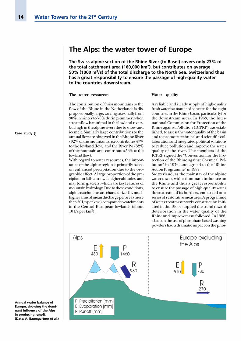
Annual water balance ofEurope, showing the domi-nant influence of the Alpsin producing runoff.(Data: A. Baumgartner et al.)
Case study j5
15
phate content of the Rhine water leavingSwitzerland, further improving the quality ofriver water.
Demands on the Rhine
Many population centres in the Rhine basindepend on the Rhine for their water supply.For example, the 4 million inhabitants of theGerman state of Baden-Württemberg ab-stract 4.4 m3/s for domestic purposes fromLake Constance, a high-quality source fed bythe alpine Rhine. Such a demand can beeasily met from a mean Rhine discharge of360 m3/s. However, hypothetically, the LakeConstance distribution network could be ex-tended to serve an area of about 100 millionpeople in Central Europe (including thosealready abstracting from the poorer qualitydownstream Rhine), for which water ab-
Case studies from Central Asia and Europe
Within Switzerland,136 km3 of water is storedin lakes and reservoirs, andanother 74 km3 in alpineglaciers. Altogether, thisstorage is five times thetotal annual river outflowfrom Switzerland.(Photo: M. Grosjean)
stractions of approximately 110 m3/s wouldbe needed. Depending on the season, thisamounts to between 18 and 50% of the meanmonthly flow of the alpine Rhine. At firstglance, the huge potential of the alpine Rhineis revealed. However, this potential is notwithout restriction. Abstracting such largequantities from a point so high on the Rhinewould have a great impact on downstreaminterests. Less water would be available forthe dilution of wastewater and for infiltrationfrom the river channel to the groundwateraquifers, shipping routes would be hindered,and downstream ecosystems threatened.
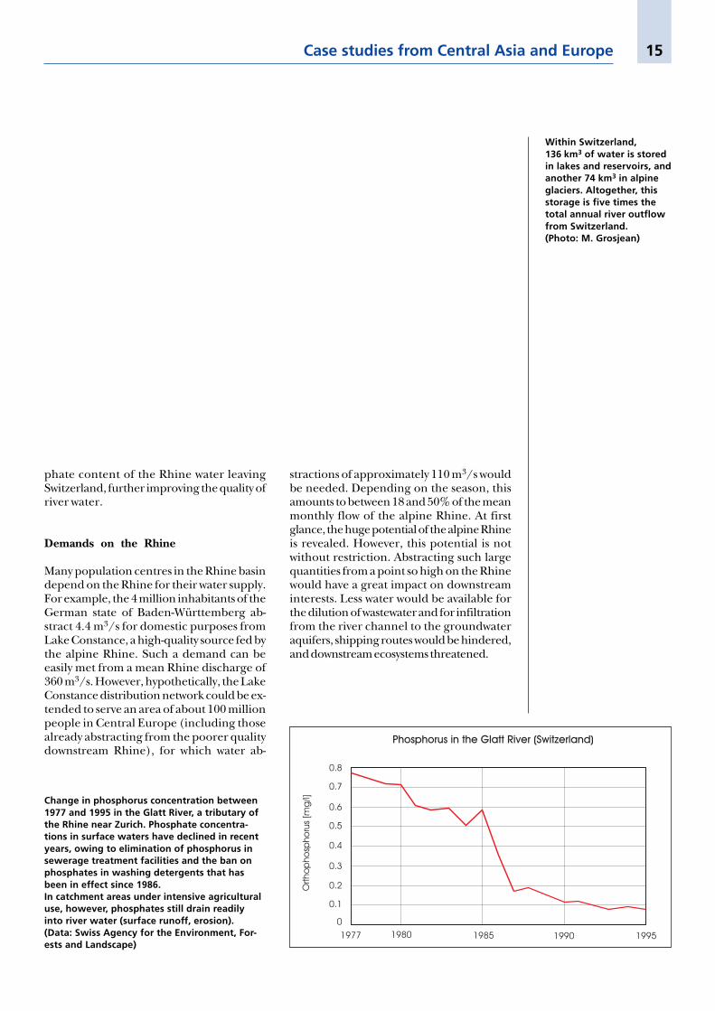
Change in phosphorus concentration between1977 and 1995 in the Glatt River, a tributary ofthe Rhine near Zurich. Phosphate concentra-tions in surface waters have declined in recentyears, owing to elimination of phosphorus insewerage treatment facilities and the ban onphosphates in washing detergents that hasbeen in effect since 1986.In catchment areas under intensive agriculturaluse, however, phosphates still drain readilyinto river water (surface runoff, erosion).(Data: Swiss Agency for the Environment, For-ests and Landscape)

16 Water Towers for the 21st Century
Gra

17
afik

18 Water Towers for the 21st Century
The previous double page presents a globalmap with the locations of the case studiespresented in this report. For selected rivers,graphs illustrate the importance of the moun-tain areas in contributing to the total riverflow in the lower part of the basins. With thedata available, it is difficult to separate thecontribution of the mountains. In most of thecases, not all of the tributaries from the moun-tains are recorded. Therefore, the figures pro-vided do not show the full extent of the moun-tain contribution to the lowland river flow.Furthermore, the lowland flows providedwere not always measured at the mouth of therivers. Nevertheless, the following examplesillustrate the importance of mountains aswater towers (in alphabetical order):
EuphratesThe mountains of the Euphrates watershedgenerate the water that is used in the Meso-potamian lowlands (Syria and Iraq). The con-sumption in the lowlands shows the greatdependency of the lowlands on external waterresources.
IndusThe water from snow- and icemelt in the Ka-rakorum, Hindu Kush and Himalaya is usedfor extensive irrigated agriculture in the aridlowlands. The peak flow in August is the resultof the monsoon rainfall (see case study 6).
MekongThe river flow from the mountains is of vitalimportance in the pre-monsoon season, con-tributing about 40 to 50% of the total flow.The downstream wet season flow is domi-nated by the monsoon rains and is mainlyprovided by the lowland watersheds (see casestudy 8).
NigerThe peak runoff from the mountains andhighlands of Guinea and Ivory Coast coin-cides with the rainy season (July to October).The Niger River transports the mountainwater to the semi-arid Sahel lowlands, wherethis vitally important water is used during thecropping season from June to November. Asa result of the great distance between the
Explanations for previous double page
mountains and the lowlands, the river flow inthe lowlands is delayed by weeks or evenmonths.
NileAll the mountains in the Nile watershed, in-cluding the White Nile, provide three timesmore water than the river flow near Cairo.During summer mountain water is stored inLake Nasser. It is used for irrigation andenergy production, and to provide a steadyflow downstream (see case study 1).
RhineThe example of the Rhine River clearly illus-trates the importance of snow- and icemeltduring spring and summer for the water sup-ply of Central Europe (see case study 5).
Rio GrandeThe lowlands in the Rio Grande watersheddepend greatly on the water towers of theRocky Mountains and Sierra Madre Orien-tal. Due to consumption and high evapora-tion rates, the water balance in the lowlandsis negative, but it is smoothed by the contri-bution of mountain waters.
Rio NegroThe water balance in the lowlands of the RioNegro is negative throughout the year. There-fore, the headwaters from the Andes (occupy-ing about 60% of the basin) play a key role inthe water supply to the arid lowlands.
SaskatchewanThe Rocky Mountains of Canada occupyonly 17% of the Saskatchewan basin, butgenerate 43% of the annual flow in the low-lands, and 80% of the flow during the sum-mer (compare with case study 11).
Syr DaryaIn the Syr Darya basin, massive water ab-straction for the irrigation of cotton has dra-matically changed the hydrological regime,which is characterized by snow- and icemelt.The water flow depicted in the lowland wasobserved in the middle course and not at themouth to the Aral Sea, where the impactwould be much greater (see case study 4).
On average, mountains inhumid areas provide 30 to60% of downstream freshwater, while this figure risesto 70 to 95% in semi-aridto arid environments.

19
Major river basins of the world
River Continent Mean Drainage area Internationaldischarge (km2) basins(m3/sec)
Amazon S. America 180,000 7,180,000 Yes
Congo Africa 42,000 3,820,000 Yes
Mississippi N. America 17,500 3,220,000 Yes
Ob Asia 12,600 2,975,000 Yes
Nile Africa 1,585 2,880,000 Yes
La Plata/Paraná S. America 19,500 2,650,000 Yes
Yenisey Asia 19,600 2,600,000 Yes
Niger Africa 5,700 2,090,000 Yes
Amur Asia 12,500 1,855,000 Yes
Zambezi Africa 2,600 1,330,000 Yes
Indus Asia 3,850 1,263,000 Yes
Orinoco S. America 28,000 1,085,000 Yes
Ganges Asia 15,000 1,075,000 Yes
St. Lawrence N. America 10,400 1,030,000 Yes
Orange Africa 349 1,020,000 Yes
Brahmaputra Asia 20,000 940,000 Yes
Yukon N. America 7,000 855,000 Yes
Euphrates-Tigris Asia 1,459 810,000 Yes
Danube Europe 5,450 805,000 Yes
Mekong Asia 15,900 795,000 Yes
Rio Grande N. America 101 670,000 Yes
Colorado N. America 168 630,000 Yes
Chari (Lake Chad) Africa 1,268 600,000 Yes
Huang He Asia 1,365 445,000 Yes
Rhine Europe 2,201 160,000 Yes
Song-Koi Asia 3,900 120,000 Yes
Lena Asia 16,400 2,490,000 No
Yangtze Asia 35,000 1,970,000 No
Mackenzie N. America 7,500 1,805,000 No
Volga Asia 8,000 1,380,000 No
A global view
What role do mountainsplay in determining thequality and quantity offresh water in the majorriver basins of the world?Further investigations areurgently needed!(Data: JRO 1981, WorldResources Institute 1992)

20 Water Towers for the 21st Century
Freshwater contribution from themountains
Although published figures differ significantly,it can be concluded that some 90% (between5600 and 6700 m3/sec) of the mean annualflow into the Indus basin originates in the frontranges and high mountains of the Hindu Kush,Karakorum and Western Himalaya. The con-tributions of the main rivers measured at thefoot of the mountains are 13% from the Kabul,37% from the Indus, 14% from the Jhelum,15% from the Chenab, 4% from the Ravi, 7%from the Beas and 10% from the Sutlej. Lessthan 10% of the average runoff is the result ofrainfall over the Indus plains.The runoff reflects the seasonal rainfall andsnowmelt regimes of the mountain water-sheds. The foothills and front ranges are pre-dominantly exposed to seasonal monsoon
Case studies from Asia
The Indus River: mountain water for theworld’s largest irrigation network
Ninety per cent of the lowland flow of the Indus River originates in thehigh mountains of the Hindu Kush, Karakorum and Western Himalaya.Three-quarters of this water is used for irrigation in the world’s largestirrigation network.
Meltwater from snowirrigates the lower aridslopes of the Hunza Valley.(Photo: M. Winiger)
rains, leading to runoff peaks from June toSeptember, which produce some 70% of thetotal annual runoff of the Indus. Up to 40%of the central parts of the Karakorum arecovered by ice. Snowfall in the high moun-tains, at altitudes above 4000 m a.s.l., is onan average equivalent to more than 2000 mmof rainfall annually. This contrasts greatlywith low rainfall in the plains (less than200 mm per year) and within the deeply in-cised mountain valleys (less than 120 mm peryear).
Mountain water for irrigation
Most of Pakistan’s 130 million inhabitantsdepend on the largest interlinked irrigationnetwork in the world, which is fed by theIndus and its tributaries. Only 25% of thecountry’s surface is arable land – of whicharound 135,000 km2 is under irrigation andonly some 65,000 km2 is suitable for rainfedagriculture. The complex irrigation system isbased on three major reservoirs, approxi-mately 20 barrages, 12 inter-river link canals,and nearly 60,000 km of main canals. Thisirrigation network plays a prime role insmoothing the difference between peak sum-mer runoff during monsoon and winter run-off. Roughly three-quarters of the river flowremains within the irrigated area, and onlysome 25% of the mountain runoff finallyreaches the Arabian Sea as system outflow. Itshould be noted, however, that occasionalsevere monsoon storms can cause major floodcatastrophes in the lowlands.The Indus Water Treaty (1960) between In-dia and Pakistan (and Pakistan’s provinces) isthe main contractual basis for the “IndusBasin Plan”. The resulting infrastructure forirrigation schemes and energy production be-came one of the main pillars of the countries’economies.
Case study j6
21
The Himalaya plays a key role in providingthe baseflow of the Ganges and the Brah-maputra, and thus in supporting the irrigationneeds and shipping routes of India and Ban-gladesh. However, the available river flowdata are not sufficient to quantify the contri-bution from the mountains to the lowlands.Furthermore, existing data are not alwaysmade available to regional or global datacentres.
The perception
With both the Ganges and the Brahmaputraflowing through several countries, “blame”for the floods in Bangladesh has become ageopolitically sensitive matter. There was andstill is a common perception that the floods inBangladesh are caused by forest removal andother human activities in the Himalaya. Thequestion of to what extent the flood processesare natural and to what extent they are influ-enced by human activities in the highlandshas aroused passionate discussions among sci-entists and politicians.
The “reality”
Recent studies have indicated that floods inBangladesh and India are largely independ-ent of human activities in the Himalaya. Nei-ther the frequency nor the volume of flooding
The Himalaya: responsible for floodsfrom local to continental scale?
It is a common assumption that the floods in Bangladesh are causedby deforestation and other human activities in the Himalaya. While theHimalayan mountains provide crucial baseflow support to the down-stream lowlands during the dry season (see case study on the Indus),they do not appear to have a significant role in the generation of floodsin Bangladesh.
has increased in Bangladesh over the last 120years. Precipitation and runoff in the Hima-laya do not seem to be important causes of thefloods in Bangladesh.An extraordinary rainfall event on 19/20 July1993 over eastern and central Nepal hadcatastrophic effects locally, with several dis-tricts hit by floods and landslides. However,the water level of the Ganges recorded atHardinge Bridge, located near the India-Bangladesh border, showed no dramatic in-fluence. The flood flow of the Nepali tributar-ies had levelled off during passage from thehills through the plains. It is thus clear that avery extreme flood event in the Himalaya ofNepal has catastrophic effects in the moun-tains and adjacent plains, but almost no im-pact on the extent of the flood peaks fardownstream in Bangladesh. The high rainfallin India’s Meghalaya Hills, and in Bangladeshitself, has been identified as a dominant factorleading to the floods.An improvement in monitoring, followed byfurther studies to clarify the processes active inthe highland-lowland system and thus the gen-eration of floods, together with cooperationamong the states sharing the mountain waterresources of the Himalaya, is needed for sus-tainable management of this great basin.
Life in Bangladesh revolvesaround water.(Photos: R. Weingartner)
Cherrapunji, situatedin the Meghalaya Hills,has an average rainfall of9500 mm between Mayand September (monsoonseason).
Case studies from Asia
M: Meghalaya Hills
Case study j7
M
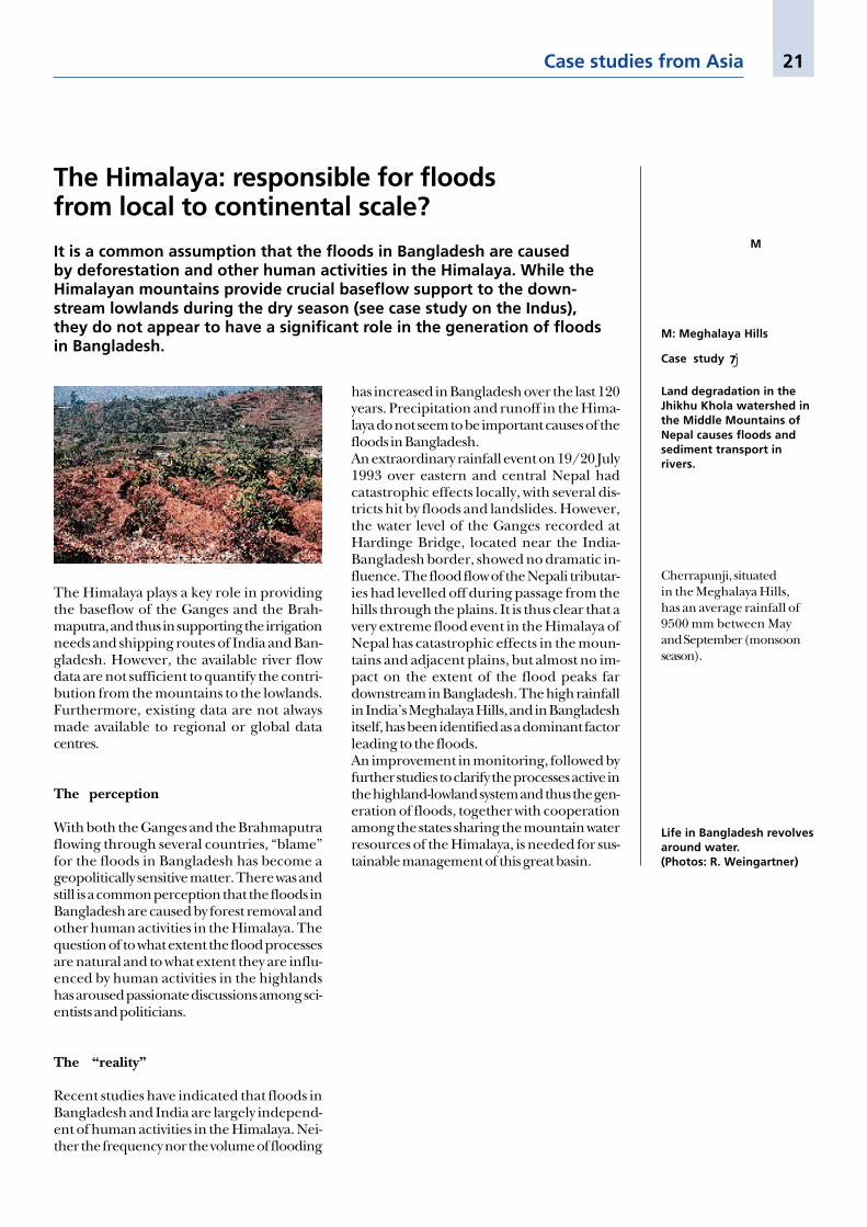
Land degradation in theJhikhu Khola watershed inthe Middle Mountains ofNepal causes floods andsediment transport inrivers.
22 Water Towers for the 21st Century
Flowing through six countries, the Mekong isone of the world’s great international rivers.From its source at over 5000 m on the Ti-betan Plateau, the Mekong flows throughChina’s Yunnan Province, touches Myanmar,forms the boundary between Laos and Thai-land, crosses Cambodia, and flows into theSouth China Sea in Vietnam. The totallength of the river is 4800 km. The down-stream wet season flow is dominated by themonsoon rains and is mainly provided by thelowland watersheds. The mountain areas,which cover about 30% of the basin, arecritical for maintaining the dry season flow, towhich they contribute between 40 and 50%.A large portion of the lowlands of the basin isdensely populated and characterized by highrates of population increase (e.g. 2.8% perannum in Cambodia).
The Mekong Basin: managing the pressuresof rapid economic development
Currently, an estimated 60 million people rely on the water of the Mekongas a basis for their livelihood. The Mekong Basin is characterized by rapideconomic growth. Large-scale dam construction and water abstractionsare planned to meet the growing demand for water. This, together withincreased pressure on mountain watersheds, is resulting in changes in theriver flow pattern and consequently in the threat of increased saltwaterintrusion into the delta area, which in turn jeopardizes rice productionand fishing productivity in the lowlands.
Conflicting demands
China has completed a dam in the mainstream channel and intends to construct sev-eral others to support industrial developmentand irrigation. Thailand, already an impor-tant user of Mekong water, has plans forinterbasin diversions from the Mekong Basinto the neighbouring Chao Phraya Basin torelieve Bangkok of its shortage of fresh water.Total planned abstractions for this project arereported to amount to 9 to 30% of the Me-kong’s dry season flow. Laos has set up anambitious programme for hydropower gener-ation mainly in the mountain areas, with aview to exporting most of it for foreign ex-change. In southern Laos alone, over 30 damsites have already been identified.
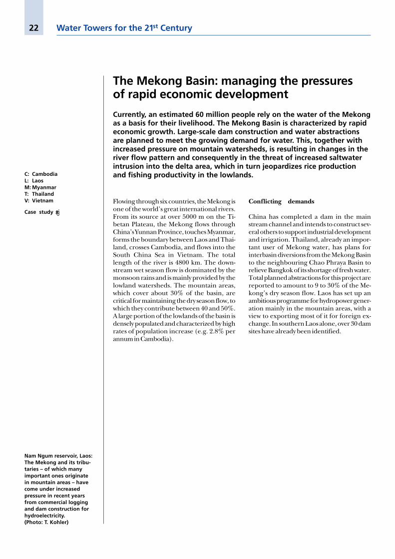
Nam Ngum reservoir, Laos:The Mekong and its tribu-taries – of which manyimportant ones originatein mountain areas – havecome under increasedpressure in recent yearsfrom commercial loggingand dam construction forhydroelectricity.(Photo: T. Kohler)
C: CambodiaL: LaosM: MyanmarT: ThailandV: Vietnam
Case study j8

23
Mountain areas in the basin are under in-creasing land use pressure. The intensity ofcommercial logging and shifting cultivationhave increased in recent years due to inap-propriate land use policies, migration andresettlement, and population growth. This in-tensified land use leads to reduced vegetationcover and thus is likely to influence the hydro-logical regime.
The likely impact
The compound effect of human activitieswithin the Mekong Basin, and especially itsupper reaches, on the river flow is difficult toassess. The three major factors to consider inthis respect are:(1) Land use change, e.g. deforestation, maylead to more extreme river flow with in-creased flood peaks and reduced dry seasonflows.(2) Dam construction for hydropower genera-tion has the opposite effect, storing peak flowsand releasing water during low flow periods.(3) Water abstractions for irrigation and fordomestic and industrial use reduce river wateravailability, mainly during low flow.The overall result of these impacts could be areduced dry season flow. This would exacer-bate the level of saltwater intrusion from thesea, which already adversely affects approxi-
Case studies from Asia
mately 60% of the Mekong Delta area. Thepotential for disruption of livelihoods in thelowlands is thus clear. The Mekong’s aquaticecosystems are unique, and its diversity of fishspecies is among the greatest in the world.Fish is the most important source of proteinfor local populations, and fishing is an impor-tant source of income. With 50% of Viet-nam’s total rice crop grown in the MekongDelta, irrigation is also a vital activity whichcould be affected by upstream changes.
The challenges ahead
Sustainable use of the Mekong water re-sources will have to be based on a basin-wide approach, the participation of all stake-holders including local populations, and jointresponsibility among the countries whichshare the basin. A fair and equitable distribu-tion of Mekong water should be based onwater resource monitoring, agreed rules ofwater use, and the preservation of the uniqueaquatic ecosystem. Proper management ofmountain watersheds will be particularly im-portant for securing sustained dry seasonflow. Achieving these aims will require exten-sive political negotiation for which the Me-kong River Commission could be a vehicle.Without such an approach, the potential forfuture conflicts is clear.
Tibetan Plateau and moun-tains: the origin of theheadwaters of some of themajor rivers of the world,among them the Mekongand the Yangtze.(Photo: M. Ryser)
24 Water Towers for the 21st Century
About 1.5% of the global ice volume is storedin mid- and low-latitude glaciers. However,due to their proximity to centres of humanpopulation and consumption, these waterreservoirs are exceedingly important. In semi-arid tropical mountains, such as the Cen-tral Andes, glaciers provide fresh meltwaterthroughout the year, even during the dryseason. Whereas Mexican glaciers (11.4 km2),African glaciers (10.9 km2), and Indonesianglaciers (6.9 km2) are limited in their extent,the glaciers in the tropical and subtropicalAndes cover 2676 km2, almost equalling the
Case studies fromthe Americas and Oceania
Glaciers in the tropical Andes:a life-line during the dry season
In Bolivia, Peru and Ecuador, glaciers are the principal natural reservoirsregulating freshwater flow during the year. Glacial meltwater, which hastraditionally been used for irrigation, is now a life-line for major Andeancities such as La Paz, the capital of Bolivia.
extent of the glaciers in the Alps (2910 km2).The 1.4 million people of La Paz and El Altodepend mostly on water supplies from sur-rounding glaciers lying above 4500 m. 75% ofthe electric power for these cities is generatedby a row of eight hydropower plants in theZongo Valley of the eastern escarpment of theAndes from 4750 m down to 1200 m altitude.Conflicts over traditional irrigation, domesticsupplies, and hydroelectric power generationhave already arisen in the Andean valleysclose to the large centres.The Zongo Glacier provides an importantbuffer against seasonal variability in precipita-tion, thus ensuring a continuous freshwatersupply for La Paz. During the dry seasonbetween April and November (monthly pre-cipitation ranging from 10 to 40 mm), theZongo Glacier alone provides La Paz with 50to 120 l/s of water. It is even able to respondimmediately in extreme dry years (e.g. ElNiño years), when meltwater discharge in-creases due to the higher temperatures. How-ever, such short-term positive effects result insubstantial ice losses from these glaciers and,ultimately, in the disappearance of this fresh-water reservoir. This is likely to be a criticalprocess in light of global warming.
The 3044 glaciers of Perustore 56.15 km3 of ice.During the dry season,most runoff is glacialmeltwater. Some of it isdiverted into irrigationchannels, many of whichare of pre-Columbianorigin. All the measuredglaciers in Peru have lostsubstantial masses of ice inrecent years: the length ofthe Broggi Glacier, whichmeasured 1.6 km in 1948,decreased by 654 mbetween 1948 and 1991.53 m of this loss occurredin 1991 alone.
The Zongo Glacier of Boliviais a water tower whichsupplies water for La Paz.(Photo: M. Grosjean)
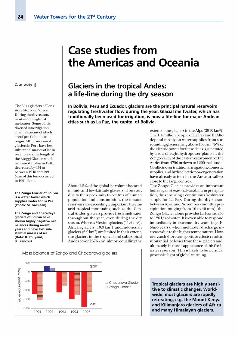
The Zongo and Chacaltayaglaciers of Bolivia haveshown highly negative netbalances during recentyears and have lost sub-stantial masses of ice.(Data: B. Pouyaud,B. Francou)
Tropical glaciers are highly sensi-tive to climatic changes. World-wide, most glaciers are rapidlyretreating, e.g. the Mount Kenyaand Kilimanjaro glaciers of Africaand many Himalayan glaciers.
Case study j9

25
The Atacama Desert in the Andes of north-ern Chile, one of the driest places on earth,yields exceptional metal ore deposits. Theextremely scarce water resources, which sus-tained the indigenous Atacameña culture forthousands of years, are currently under ex-treme pressure from the mining industry andgrowing urban areas. The water resourcesgenerated in the high mountains of the An-des are transported by pipeline over hun-dreds of kilometres to areas of demand, i.e.the large copper mines and expanding urbancentres.
The water resources
Due to their orographic effect, the highmountains of the central Andes form a rainfallzone in the Atacama Desert, while areas be-low 3000 m altitude receive virtually no rain-fall. However, annual precipitation in thehighest mountains rarely exceeds 200 mm,and most of the groundwater resources in thebasins were recharged during wetter climaticphases thousands of years ago. Thus they arenon-renewable water resources. Total avail-able water resources in the area (126,000 km2)are 10 m3/s.
Andean water: supply for the world’s largestcopper mines in Chile
The entire economic development of the Atacama Desert depends onsmall streams that come from the Andes. These mountain water resourcesare of vital importance. Further economic growth in one of the richestmining areas of the world is limited by these resources.
Resource use and conflicts
The “sacred” water resources from the moun-tains have traditionally been used for irri-gation of agricultural fields in small oases inthe foot zones of the mountains. In recentyears, however, the copper, gold and lithiumdeposits have been exploited and currentlyaccount for the greater part of the Chileannational budget. In 1994, the Atacama Desertgenerated 17% of the world’s copper produc-tion. More than 7 billion US dollars are cur-rently invested in new mining operations.Mining in the Atacama accounts for 95% ofregional exports, and for 30% of total Chileanexports. With these mining activities, the de-mand for water has increased rapidly. In1996, claims submitted for water rightsamounted to 16 m3/s, greatly exceeding the10 m3/s currently available.
Water captured from thePutana River of the Ataca-ma Desert is carried overhundreds of kilometres tocentres of demand, i.e.the growing cities and thelarge copper mines, suchas the Chuquicamata mine(until 1992 the world’slargest open cast coppermine).
The worship of mountainsfor their water was a fea-ture of Inca culture. Theweather god Illapa livesin the mountains, and con-trols rain, storms, light-ning, hail and snow. In theAtacama Desert of north-ern Chile, children werereportedly sacrificed annu-ally to the mountain godfor rain to ensure a securewater supply.(Photos: M. Grosjean)
Case studies from the Americas and Oceania
Case study j10
! New investments inmining activities

26 Water Towers for the 21st Century
The Fraser River, draining 234,000 km2, is1375 km long with a mean annual flow of3972 m3/s. Its headwaters originate in theRockies, which are dominated by glaciers andsnowmelt. More than 85% of the basin con-sists of mountains that are highly diverse, withan extreme climatic variability ranging from300 mm annual precipitation in the CentralPlateau to more than 3500 mm in the CoastalMountains. The latter, which occupy only20% of the total catchment, provide 60% ofthe annual flow.
The salmonid habitat
The Fraser River is one of the leading salmo-nid-bearing systems in the world. It is estimat-ed that more than 7 million migrating salmonenter the river each year, which is commer-cially and recreationally important. The hy-drological conditions are vital for the survivalof the salmon, particularly in the late autumnwhen the salmon make their long journey upthe river to spawn. In contrast to many othermajor salmonid rivers (e.g. the Columbia ba-sin, USA), the passage of the salmon up theFraser River is not impeded by hydropowerdevelopment.
The Fraser River of the Rocky Mountains:a highly productive ecosystem for salmonids
The Fraser River of Canada is one of the few major basins in the RockyMountains with no mainstream hydropower or dam construction.This, combined with the ability of the mountain fresh water to dilute thecurrent level of wastewater discharges in the lower part of the basin,has helped to preserve one of the most productive ecosystems for salmo-nids in the world.
The importance of the Fraser River ecosys-tem is accentuated by the general trend ofrapidly decreasing catches of Pacific salmon,currently the subject of much debate. Over-fishing, habitat loss due to urbanization, pol-lution of the streams, siltation of spawningareas due to soil erosion and clear-cut de-forestation on the steep slopes of the moun-tains, and fluctuations in flow due to unusualclimatic variability over the past 5 years areviewed as the main causes of the decline.
The dilution power of mountainfresh water
85% of the 1.8 million people resident in theFraser basin live in the Lower Fraser Valley.Although it constitutes less than 10% of thecatchment area, this area is responsible for70% of total wastewater discharges from ur-ban, industrial and agricultural sources. Afurther significant source of pollution origi-nates from the pulp mills located along themiddle section of the river. The hydrologicalregime of the Fraser River, which is domi-nated by inflow from the headwaters in theRocky Mountains, is able to dilute currentwastewater discharges, ensuring water qualitythat does not impede the passage of salmo-nids. However, careful wastewater manage-ment is required to maintain the unique eco-system of the Fraser basin for the future.
Agricultural and industrialdevelopment in the LowerFraser Valley.(Photo: H. Schreier)
Fragile mountain eco-systems: salmon habitatsare severely threatenedby suspended sedimentloads originating at log-ging sites (such as those inthe Columbia River water-shed, Washington StateUSA), and by infrastructuredevelopment on steepmountain slopes.(Photo: M. Grosjean)
Case study j11
27
The Southern Alps of New Zealand are a chainof mountains 2000 to 3000 m high and over500 km long which form a barrier to moist,mid-latitude, westerly, maritime air streams.The resultant orographic rainfall on the wind-ward slopes is more than 12,000 mm a year insome areas, while annual rainfall over the lowelevation areas in the rain shadow is less than500 mm. Extensive seasonal snow accumula-tion occurs at altitudes exceeding 1000 m, withperennial snow and ice found above 2200 m.
The hydrological conditions
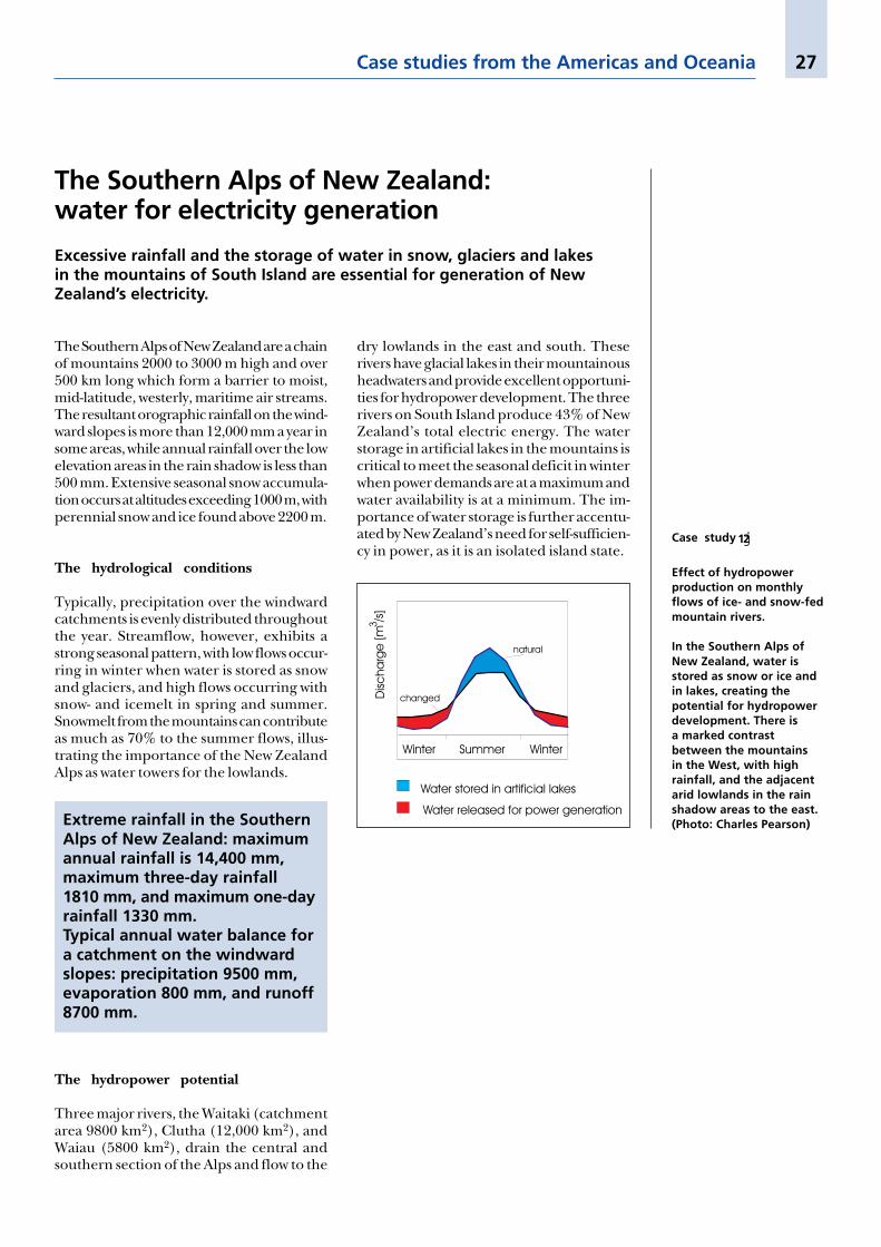
Typically, precipitation over the windwardcatchments is evenly distributed throughoutthe year. Streamflow, however, exhibits astrong seasonal pattern, with low flows occur-ring in winter when water is stored as snowand glaciers, and high flows occurring withsnow- and icemelt in spring and summer.Snowmelt from the mountains can contributeas much as 70% to the summer flows, illus-trating the importance of the New ZealandAlps as water towers for the lowlands.
The Southern Alps of New Zealand:water for electricity generation
Excessive rainfall and the storage of water in snow, glaciers and lakesin the mountains of South Island are essential for generation of NewZealand’s electricity.
dry lowlands in the east and south. Theserivers have glacial lakes in their mountainousheadwaters and provide excellent opportuni-ties for hydropower development. The threerivers on South Island produce 43% of NewZealand’s total electric energy. The waterstorage in artificial lakes in the mountains iscritical to meet the seasonal deficit in winterwhen power demands are at a maximum andwater availability is at a minimum. The im-portance of water storage is further accentu-ated by New Zealand’s need for self-sufficien-cy in power, as it is an isolated island state.
Case studies from the Americas and Oceania
Extreme rainfall in the SouthernAlps of New Zealand: maximumannual rainfall is 14,400 mm,maximum three-day rainfall1810 mm, and maximum one-dayrainfall 1330 mm.Typical annual water balance fora catchment on the windwardslopes: precipitation 9500 mm,evaporation 800 mm, and runoff8700 mm.
The hydropower potential
Three major rivers, the Waitaki (catchmentarea 9800 km2), Clutha (12,000 km2), andWaiau (5800 km2), drain the central andsouthern section of the Alps and flow to the
Case study j12
Effect of hydropowerproduction on monthlyflows of ice- and snow-fedmountain rivers.
In the Southern Alps ofNew Zealand, water isstored as snow or ice andin lakes, creating thepotential for hydropowerdevelopment. There isa marked contrastbetween the mountainsin the West, with highrainfall, and the adjacentarid lowlands in the rainshadow areas to the east.(Photo: Charles Pearson)

Mountain regions are under pressure frominternal factors such as deforestation, agri-culture, and tourism, and from increasingdemands on their resources in the denselypopulated lowlands. Rapid and increasingchanges in mountain landscapes, and increas-ing demands on mountain resources, willhave many impacts on freshwater availability.The case studies presented here show thatwithout comprehensive assessment of theseimpacts, and without an integrated basinmanagement approach, the results can bedisastrous. Maintaining the role of mountainsas water towers will require that the followingchallenges are met:
Managing increasing demandsfor fresh water
Fresh water has already become a scarce re-source in many parts of the world. Even withimproved water use efficiency and demandreduction strategies, the need for fresh waterfor domestic use, irrigated agriculture, energygeneration and industrial production will con-tinue to grow. Mountains will be expected tosatisfy the greater part of this increasing de-mand. Thus, freshwater resources must be carefullymanaged, starting at the source – in the mountainregions themselves.
Safeguarding biodiversity andnatural habitats created by mountainfresh water
Mountain areas are often “hot spots” of biodi-versity, especially in the tropics and subtropics.Mountain water resources sustain many natu-
Mountain waters:challenges for the 21st centuryAccess to clean fresh water is a basic human right which has not yet beenachieved for all. As the “water towers” of the world, mountains are ofparamount importance for safe drinking water, and for food, energy, andindustrial production. They also support unique ecosystems and bio-diversity in both the highlands and the lowlands. Increasing demands onlimited water resources, which result in a growing potential for conflicts,ensure that mountain water resources will play a prominent role insustainable development in the 21st century. Preserving mountains aswater towers is a major challenge that humankind must face.
ral habitats, both in the mountains and thelowlands. Forests and other types of vegetationin mountain ecosystems play a key role in thewater-related functions of mountains. Maintain-ing protected areas and natural ecosystems in the moun-tains is necessary not only for ethical reasons but also topreserve natural resources for coming generations.
Recognizing interactions betweenthe mountains and the lowlands
In many regions, mountains are marginal ar-eas for human habitation, as they are limitedby steep slopes, poor soils, cool temperatures,and inaccessibility. The surrounding lowlandsare more favourable to the location of settle-ment, agriculture, and industry, but remaindependent on the mountains for water re-sources. In some regions (e.g. in many partsof the tropics), however, mountains are pre-ferred areas of human habitation becausethey have better climate and soils. Case stud-ies illustrate that mountains in humid areasprovide 30 to 60% of downstream fresh wa-ter, while this figure rises to 70 to 95% insemi-arid to arid environments. Increasedhuman activities upstream may reduce thequality and quantity of the flows downstreamon which lowland users depend. Conversely,over-development downstream may imposean unsustainable demand on the water towersupstream. There is thus a complex interactionbetween mountains and downstream low-lands which needs to be recognized. Thisinteraction should be given paramount con-sideration in planning resource development.There is a great need to increase awareness of the valueof mountains as water resource towers and the impactthey have on the lowlands.
28 Water Towers for the 21st Century
Assessing mountain water resourcesand the impact of human activities
The increasing pressure for development inthe mountains brings with it the danger ofaltering river flows and changing water qual-ity. A global assessment of mountain waterresources, their quantity and quality, andtheir limits for use is now required. Addition-ally, the effects of land use change in themountains and on river flow and water qual-ity in the lowlands must be properly assessedat different scales. In many mountain areas ofthe world, there is inadequate monitoring ofnatural resources (water, soil and vegetation),and the impact of human activities on theavailability and quality of these resources inmountain areas and downstream lowlands.This, coupled with poor dissemination of in-formation where such data are recorded,makes assessment of water resources a consid-erable challenge. The lack of monitoring ispartly due to the harsh conditions in moun-tain regions, together with a lack of invest-ment. There is a great need to improve the currentmonitoring of mountain water and land resources, andto assess the impact of human activities in the moun-tains on natural resources. Above all, there is an urgentneed to make data publicly available and to exchangeknowledge between neighbouring countries, from themountains to the lowlands.
Investing in mountains
More emphasis must be given to sustainablemountain development, to maintenance ofmountains as water towers, and to water qual-ity. This requires investment in the moun-tains in terms of long-term monitoring, waterresource assessment, and empowerment ofmountain people as stewards of these watertowers. In cases where the lowlands are eco-nomically better off than the highlands, thelowland communities must invest in themountains or compensate for the servicewhich mountains provide to downstreamareas. In the reverse situation, highland com-munities need to take into account their low-land neighbours and ensure the dischargeof enough clean water to sustain lowland in-habitants and natural habitats. If both moun-tain and lowland communities are economi-cally disadvantaged, then the compensationto mountain communities for their steward-ship should come from the national or inter-national community. The challenge is to identifyinvestment mechanisms for the sustainable developmentof both the mountains and the lowlands.
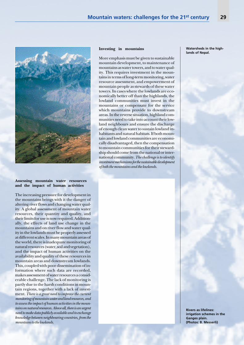
Watersheds in the high-lands of Nepal.
Mountain waters: challenges for the 21st century 29
Rivers as lifelines:irrigation schemes in theGanges plain.(Photos: B. Messerli)
Avoiding conflicts
The case studies presented here very clearlyshow the high potential for conflict over wa-ter resources between highland and lowlandusers within a basin. As most basins stretchacross administrative or national boundaries,
30 Water Towers for the 21st Century
Conclusion:implementing integrated basin management
Integrated basin management encompassing both the mountains andthe lowlands is the key to meeting the above challenges. Planning andmanagement tools at the local, national and international levels shouldbe further developed, together with better cooperation between deci-sion makers, researchers, planners and users at all levels. A major effortmust be made to identify win-win solutions for people living in bothhighland and lowland areas. Only an integrated basin management ap-proach can ensure the continued role of mountains as water towers forhumankind in the 21st century and meet the expectations identified inChapters 13 and 18 of Agenda 21.
improved methods of equitable water alloca-tion and improved regulation of water ab-stractions are important pre-requisites to min-imize conflict. Transboundary water managementsupported by political commitment is needed, especiallyfor basins in semi-arid and arid regions where waterresources are scarce.

Mountain water from theWeisshorn, Switzerland.(Photo: H.P. Liniger)
Mountain waters: challenges for the 21st century 31
32 Water Towers for the 21st Century
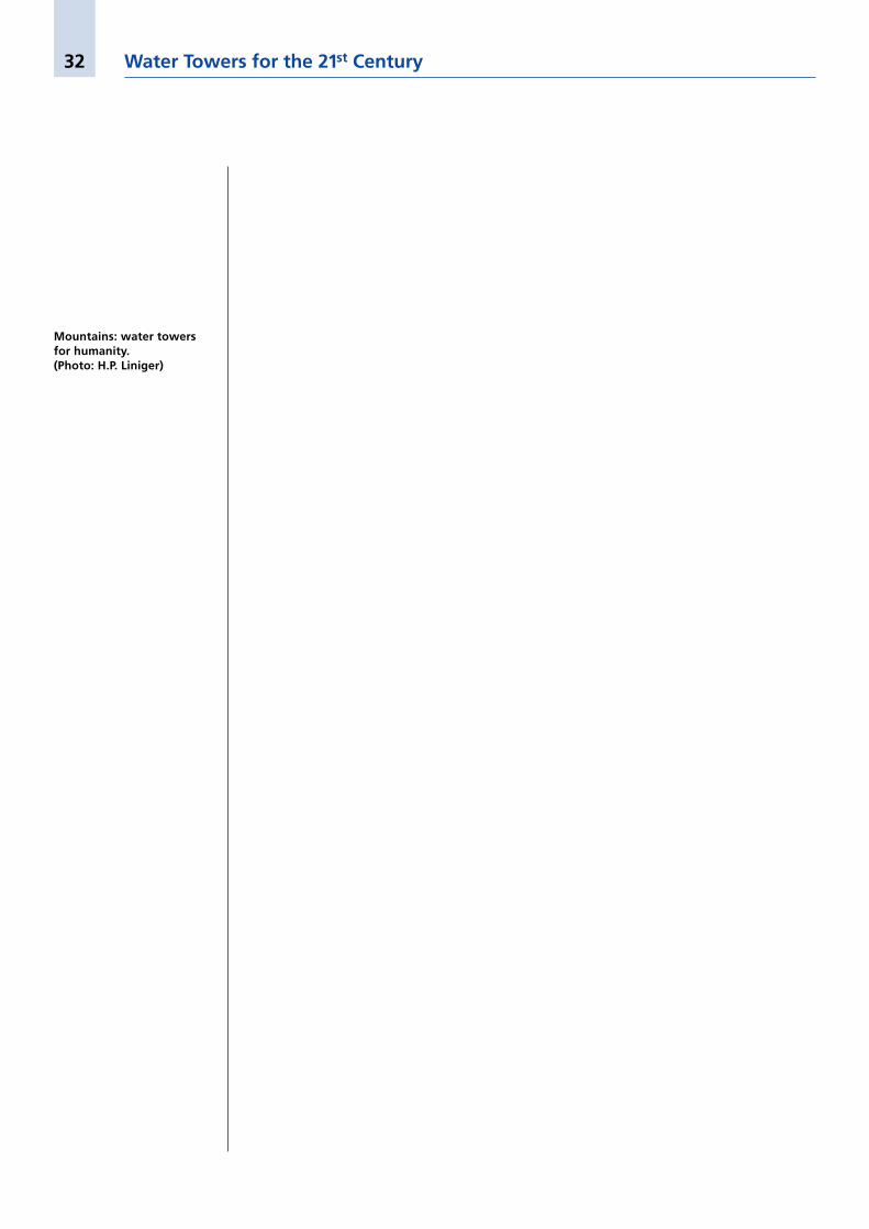
Mountains: water towersfor humanity.(Photo: H.P. Liniger)