mountain view drive / mccarrey street intersection & safety
TRANSCRIPT

Mountain View Drive / McCarrey Street Intersection & Safety Upgrades
Draft Design Study Report
PM&E Project No. 10-012
Prepared for: Municipality of Anchorage
Project Management & Engineering
September 10, 2012
Prepared by: Kinney Engineering, LLC
750 West Dimond Blvd., Suite 203 Anchorage, Alaska 99515
907-346-2373

Mountain View Drive / McCarrey Street Intersection & Safety Upgrades Project No. 10-012 Draft Design Study Report
Kinney Engineering, LLC ii September 2012
EXECUTIVE SUMMARY
The purpose of this Draft Design Study Report (DDSR) is to select a preferred alternative to achieve the project goals of improving vehicular and pedestrian safety, reducing traffic congestion, and improving traffic circulation at the Mountain View Drive / McCarrey Street intersection, and to estimate the costs to design, permit, and construct the alternative.
The construction year of this project is 2014, and the design life is 20 years.
Currently, the intersection experiences higher than average delay times for northbound vehicles on McCarrey Street turning left on Mountain View Drive. These vehicles experience a PM Peak of Level of Service (LOS) D. In addition, pedestrians wishing to access Davis Park experience LOS F while awaiting crossing gaps in the east-west traffic stream. Under a moderate traffic growth rate scenario, the intersection operations would continue to decline to a level of service F for the northbound left-turn movement by the design year (2034).
The following steps were taken to identify and develop alternatives to address the project goals and objectives:
A review of existing conditions was conducted which included a compilation of record drawings showing the locations of right-of-way (ROW) limits, roadway improvements and existing utilities. The most significant utility in the project area is the 42-inch water main serving Anchorage from the Eklutna Water Treatment Facility which is located underneath the pathway on the north side of Mountain View Drive. ROW for these two MOA maintained streets is owned by the Alaska Department of Transportation and Public Facilities (DOT&PF), requiring their coordination and approval of project plans.
A drainage analysis was performed to determine the adequacy of existing drainage structures and potential drainage of the alternatives. It was determined that implementation of any of the alternatives resulted in very little impact to existing drainage patterns.
A geotechnical paper study and site reconnaissance were conducted to identify any potential subsurface soils issues and to determine likely roadway structural section and surfacing recommendations.
A traffic analysis was performed to quantify existing safety and capacity issues, and analyze capacity and performance of each alternative in the construction year, 10-year, and 20-year design life.
Public involvement has been, and will continue to be conducted. Activities to date include a public open house, agency scoping meeting, request for input from the public, and production of a Concept Report. A project website has been established, and future public involvement process will include additional public meetings, presentations to the Planning & Zoning and Urban Design Commissions, and individual stakeholder contact as needed.
Four Alternatives were considered:
Alternative A, no-build, with minor revision of installing an all-way stop sign control

Mountain View Drive / McCarrey Street Intersection & Safety Upgrades Project No. 10-012 Draft Design Study Report
Kinney Engineering, LLC iii September 2012
Alternative B, signalization, with options of an eastbound auxiliary lane and driveway approach Alternative C, modern roundabout
o Option #1 would be three one-lane approach legs, single circulatory lane o Option #2 would modify Option #1 by adding north leg to replace an existing Park
driveway, and an eastbound right-turn yield on exit leg bypass lane. Alternative D, raised median island for pedestrian refuge.
The recommended alternative is Alternative C Option #1 or Option #2, as these accomplish the project goals by improving both pedestrian and vehicle operations and safety and has the least impact to the land adjacent to the project of the two roundabout alternatives. These are depicted below.
Alternative C Option #1- 3-leg Roundabout

Mountain View Drive / McCarrey Street Intersection & Safety Upgrades Project No. 10-012 Draft Design Study Report
Kinney Engineering, LLC iv September 2012
Alternative C Option #2- 4-leg Roundabout with Eastbound Right-Turn Bypass Lane
Roundabout operations are superior to the signalized intersection operations in the construction year, mid-year, and in the design year of the project. The addition of a right-turn bypass lane improves operational performance even more and can be installed as part of this project or in the future. Traffic forecast and operational analyses indicate that the bypass lane will not be needed until very near the design year of 2034.
Roundabouts improve pedestrian safety and circulation by providing designated crossing locations on all legs of the intersection with connections to existing trails and pathways. Pedestrians will only need to negotiate a single lane of traffic at a time and will have a refuge island between lane crossings to wait for gaps to safely cross. Long term maintenance costs are lower in comparison with a signalized intersection.
The cost estimate for the recommended alternative is summarized below.
Construction Costs Totals Option #1 Totals Option #2
CONSTRUCTION+25% Contingency $ 1,626,400 $ 1,690,500
CONSTRUCTION ADMINISTRATION $ 304,900 $ 317,000
DESIGN & PERMITTING $ 304,900 $ 317,000
TEMPORARY EASEMENTS/PERMITS $ 30,000 $ 30,000
UTILITY RELOCATIONS $ -0- $ -0-
TOTAL ESTIMATE ALTERNATIVE C $ 2,672,900 $ 2,777,100
Mountain View Drive / McCarrey Street Intersection & Safety Upgrades Project No. 10-012 Draft Design Study Report
Kinney Engineering, LLC v September 2012
Table of Contents EXECUTIVE SUMMARY ........................................................................................................................ ii
1. INTRODUCTION ............................................................................................................................ 1
1.1 General and Project Location .................................................................................................. 1
1.2 Purpose ................................................................................................................................... 1
1.3 Need ........................................................................................................................................ 3
2. HISTORY........................................................................................................................................ 3
3. EXISTING CONDITIONS ................................................................................................................ 3
3.1 Facility Description................................................................................................................... 3
3.2 Land Use, Context and Setting ................................................................................................ 4
3.3 Pedestrian and Non-Motorized Facilities .................................................................................. 6
3.4 Landscape ............................................................................................................................... 6
3.5 Drainage .................................................................................................................................. 6
3.6 Utilities ..................................................................................................................................... 7
3.6.1 Natural gas (ENSTAR) ..................................................................................................... 7
3.6.2 Sewer (AWWU) ................................................................................................................ 7
3.6.3 Water (AWWU) ................................................................................................................. 7
3.6.4 Electric (ML&P) ................................................................................................................. 8
3.6.5 Storm Drain (MOA, DOT&PF) ........................................................................................... 8
3.6.6 Communications (Telephone, Cable Television) GCI, ACS .............................................. 8
3.7 Public Transportation ............................................................................................................... 8
4. Existing Traffic Conditions .............................................................................................................. 9
4.1 Existing Volumes ..................................................................................................................... 9
4.1.1 Average Annual Daily Traffic ............................................................................................ 9
4.1.2 Peak Hour Turning Movements ...................................................................................... 10
4.1.3 Pedestrian and Bicycle Counts ....................................................................................... 11
4.2 Speeds .................................................................................................................................. 16
4.3 Crashes ................................................................................................................................. 16
4.4 Capacity Analyses ................................................................................................................. 17
4.4.1 Two-way Stop Controlled Intersection ............................................................................ 18
4.4.2 Pedestrians .................................................................................................................... 18
4.5 Signalization Warrants ........................................................................................................... 19
Mountain View Drive / McCarrey Street Intersection & Safety Upgrades Project No. 10-012 Draft Design Study Report
Kinney Engineering, LLC vi September 2012
5. TRAFFIC FORECASTS ................................................................................................................ 22
5.1 Anchorage 2027 Traffic Demand Model ................................................................................. 22
5.2 Growth Rate .......................................................................................................................... 22
5.3 Forecast Turning Movement Volumes ................................................................................... 24
6. DESIGN STANDARDS AND CRITERIA ....................................................................................... 25
6.1 General .................................................................................................................................. 25
6.2 Design Standards .................................................................................................................. 26
6.2.1 Design Criteria Manual ................................................................................................... 26
6.2.2 DOT&PF Highway Preconstruction Manual .................................................................... 26
6.2.3 Other design guidelines and standards ........................................................................... 26
6.3 Functional Classification ........................................................................................................ 26
6.4 Design Criteria ....................................................................................................................... 26
6.5 Planning Documents: ............................................................................................................. 26
7. ALTERNATIVE IDENTIFICATION ................................................................................................ 28
7.1 Alternative A- Existing Condition, “No Build” .......................................................................... 28
7.2 Alternative B- Signalized Intersection .................................................................................... 29
7.3 Alternative C- Modern Roundabout ........................................................................................ 31
7.4 Alternative D- Raised Median Pedestrian Crossing................................................................ 33
8. SOILS AND PAVEMENT DESIGN ............................................................................................... 34
9. PERMITTING REQUIREMENTS .................................................................................................. 34
9.1 Federal Permits ..................................................................................................................... 34
9.2 State of Alaska Permits ......................................................................................................... 34
9.3 Municipality of Anchorage Permits ......................................................................................... 35
10. PEDESTRIAN AND NON-MOTORIZED TRAIL FACILITIES ..................................................... 37
10.1 Design Criteria ....................................................................................................................... 37
10.2 Planning Documents and Future Plans .................................................................................. 37
10.3 Pedestrian and Non-Motorized Transportation Recommendations ........................................ 37
10.4 Alternative A (No-Build)- Pedestrian and Non-Motorized Facilities ......................................... 38
10.5 Alternative B (Signalization)- Pedestrian and Non-Motorized Facilities .................................. 38
10.6 Alternative C (Modern Roundabout)- Pedestrian and Non-Motorized Facilities ...................... 38
10.7 Alternative D (Pedestrian Median Refuge)- Pedestrian and Non-Motorized Facilities ............ 38
11. DRAINAGE ANALYSIS ............................................................................................................. 39
11.1 Summary ............................................................................................................................... 39
Mountain View Drive / McCarrey Street Intersection & Safety Upgrades Project No. 10-012 Draft Design Study Report
Kinney Engineering, LLC vii September 2012
11.2 Results and Recommendations ............................................................................................. 39
11.2.1 Alternative A (No-Build)- Drainage Considerations ......................................................... 39
11.2.2 Alternative B (Signalization)- Drainage Considerations ................................................... 39
11.2.3 Alternative C (Roundabout)- Drainage Considerations ................................................... 40
11.2.4 Alternative D (Pedestrian Median Refuge)- Drainage Considerations ............................. 40
11.2.5 Water Quality .................................................................................................................. 40
12. UTILITY IMPACTS .................................................................................................................... 40
12.1 Natural gas (ENSTAR) .......................................................................................................... 40
12.2 Sewer (AWWU) ..................................................................................................................... 40
12.3 Water (AWWU) ...................................................................................................................... 41
12.3.1 Alternative A (No-Build)- Water (AWWU) Utility Impacts ................................................. 41
12.3.2 Alternative B (Signalization)- Water (AWWU) Utility Impacts .......................................... 41
12.3.3 Alternative C (Roundabout)- Water (AWWU) Utility Impacts ........................................... 41
12.3.4 Alternative D (Pedestrian Median Refuge)- Water (AWWU) Utility Impacts .................... 41
12.4 Electric (ML&P) ...................................................................................................................... 42
12.4.1 Alternative B (Signalization)- Electric (ML&P) Utility Impacts .......................................... 42
12.4.2 Alternative C (Roundabout)- Electric (ML&P) Utility Impacts ........................................... 42
12.5 Communications (telephone, cable television) ACS, GCI....................................................... 42
13. ACCESS AND RIGHT-OF-WAY CONSIDERATIONS ............................................................... 42
13.1 Access ................................................................................................................................... 42
13.1.1 Alternative B (Signalization)- Driveway Impacts .............................................................. 43
13.1.2 Alternative C (Roundabout)- Driveway Impacts .............................................................. 43
13.2 Davis Park Driveway Discussion and Analysis ....................................................................... 44
13.2.1 Close off Davis Park Driveway ........................................................................................ 44
13.2.2 Reconfigure Davis Park driveway as “right- in, right-out” ................................................ 45
13.2.3 Relocate Davis Park driveway to 4th leg of intersection ................................................... 45
13.2.4 Davis Park Driveway Recommendation .......................................................................... 46
13.3 Driveway Entrance to MOA Snow Disposal / Storage Site ..................................................... 46
13.4 Right-of-Way.......................................................................................................................... 46
13.4.1 Mountain View Drive ....................................................................................................... 46
13.4.2 McCarrey Street ............................................................................................................. 47
13.4.3 Alternative A (No-Build)- Right-of-Way Impacts .............................................................. 47
13.4.4 Alternative B (Signalization)- Right-of-Way Impacts ........................................................ 47

Mountain View Drive / McCarrey Street Intersection & Safety Upgrades Project No. 10-012 Draft Design Study Report
Kinney Engineering, LLC viii September 2012
13.4.5 Alternative C (Roundabout)- Right-of-Way Impacts ........................................................ 47
13.4.6 Alternative D (Pedestrian Median Refuge)- Right-of-Way Impacts .................................. 47
13.5 Parking .................................................................................................................................. 47
14. MAINTENANCE CONSIDERATIONS ....................................................................................... 48
14.1 Alternative A (No-Build)- Maintenance ................................................................................... 48
14.2 Alternative B (Signalization)- Maintenance ............................................................................ 48
14.2.1 Storm Drain Maintenance (Alternative B) ........................................................................ 48
14.2.2 Signals and Street Light Maintenance (Alternative B) ..................................................... 48
14.2.3 Landscape Maintenance (Alternative B) ......................................................................... 48
14.2.4 Snow Removal (Alternative B) ........................................................................................ 48
14.3 Alternative C (Roundabout)- Maintenance ............................................................................. 48
14.3.1 Storm Drain Maintenance (Alternative C) ........................................................................ 48
14.3.2 Signals and Street Light Maintenance (Alternative C) ..................................................... 49
14.3.3 Landscape Maintenance (Alternative C) ......................................................................... 49
14.3.4 Snow Removal (Alternative C) ........................................................................................ 49
14.4 Alternative D (Pedestrian Median Refuge)- Maintenance ...................................................... 49
14.4.1 Storm Drain Maintenance (Alternative D) ........................................................................ 49
14.4.2 Snow Removal (Alternative D) ........................................................................................ 49
15. STREET ILLUMINATION (DOT&PF) ........................................................................................ 49
15.1 Alternative B (Signalization)- Street Illumination ................................................................... 49
15.2 Alternative C (Roundabout)- Street Illumination ..................................................................... 50
16. LANDSCAPING ........................................................................................................................ 50
17. CONSTRUCTION PHASING AND TRAFFIC CONTROL .......................................................... 50
18. PUBLIC INVOLVEMENT SUMMARY ........................................................................................ 51
19. TRAFFIC OPERATION AND SAFETY ...................................................................................... 51
20. COST ESTIMATES ................................................................................................................... 57
20.1 Alternative A, Option #2 Cost Estimate- All-Way Stop ........................................................... 57
20.2 Alternative B Cost Estimate- Signalized Intersection .............................................................. 58
20.3 Alternative C Cost Estimate, Roundabout .............................................................................. 58
20.4 Alternative D Cost Estimate, Raised Median Pedestrian Refuge ........................................... 59
21. SCHEDULE AND TIMELINE ..................................................................................................... 59
22. ALTERNATIVE EVALUATION AND RECOMMENDATION ....................................................... 59
22.1 Alternatives Evaluation .......................................................................................................... 59

Mountain View Drive / McCarrey Street Intersection & Safety Upgrades Project No. 10-012 Draft Design Study Report
Kinney Engineering, LLC ix September 2012
22.1.2 Alternatives Comparison ................................................................................................. 60
22.2 Recommended Alternative ..................................................................................................... 62
List of Figures Figure 1. Project Location ..................................................................................................................... 2 Figure 2. Land Use and Zoning ............................................................................................................. 5 Figure 3. Historical AADTs for Mountain View Drive and McCarrey Street ............................................ 9 Figure 4. Morning Peak Hour Turning Movement Counts (May 2012) ................................................. 10 Figure 5. Mid-day Peak Hour Turning Movement Counts (May 2012) ................................................. 11 Figure 6. Evening Peak Hour Turning Movement Counts (May 2012) ................................................. 11 Figure 7. Pedestrian Routes in Study Area .......................................................................................... M Figure 8. Morning Peak Hour Pedestrian and Bicycle Counts (May 2012) .......................................... 14 Figure 9. Mid-day Peak Hour Pedestrian and Bicycle Counts ............................................................. 14 Figure 10. Evening Peak Hour Pedestrian and Bicycle Counts (May 2012) ........................................ 15 Figure 11. Late Evening Peak Hour Pedestrian and Bicycle Counts (May 2012) ................................ 15 Figure 12. AADT Output from Anchorage 2027 Traffic Demand Model ............................................... 22 Figure 13. Historical Population and Traffic Volumes for Anchorage 1997 to 2009 ............................. 23 Figure 14. Forecast AADTs for Mountain View Drive and McCarrey Street (0%, 1%, and 2% annual growth rates) ........................................................................................................................................ 24 Figure 15. Alternative A Option #2- “No Build” with All Way Stop ........................................................ 28 Figure 16. Alternative B- Signalized Intersection ................................................................................. 29 Figure 17. Alternative C Option #1- 3-legged Roundabout .................................................................. 31 Figure 18. Alternative C Option #2- 4-legged Roundabout w/ Bypass Lane ........................................ 32 Figure 19. Alternative D- Raised Median Pedestrian Crossing ............................................................ 33 Figure 20. Driveway Impacts & Options .............................................................................................. 43

Mountain View Drive / McCarrey Street Intersection & Safety Upgrades Project No. 10-012 Draft Design Study Report
Kinney Engineering, LLC x September 2012
List of Tables
Table 1. Crashes by Year and Type of Crash – 2001 through 2010 .................................................... 16 Table 2. Intersection Crash Rate – 2001 through 2010 ....................................................................... 17 Table 3. Delay Threshold Levels for Two-Way Stop Controlled Intersections ..................................... 18 Table 4. Automobile LOS for Existing Conditions Peak Periods .......................................................... 18 Table 5. Delay Threshold Levels for Pedestrian Crossing at Uncontrolled Location ............................ 19 Table 6. Pedestrian Level of Service for Existing Conditions Peak Periods ......................................... 19 Table 7. Signal Warrant Evaluation ..................................................................................................... 21 Table 8. Future Turning Movement Volumes for Mountain View Drive/McCarrey Street (0%, 1%, and 2% growth rate) ................................................................................................................................... 25 Table 9. Design Criteria for Mountain View Drive & McCarrey Street ................................................... 27 Table 10. Anticipated Permitting Requirements ................................................................................... 36 Table 11. Comparison of Vehicle Delay, Queue Length, and Level of Service for Alternatives ... 52 Table 12. Comparison of Pedestrian Delay and Level of Service for Alternatives ........................ 53 Table 13. Comparison of Intersection Crash Rate – 2001 through 2010 for Alternatives ............. 54 Table 14. Alternative A Option #2 Estimated Costs .............................................................................. 57 Table 15. Alternative B Estimated Costs .............................................................................................. 58 Table 16. Alternative C- Options #1 & 2 Estimated Costs .................................................................... 58 Table 17. Alternative D Estimated Costs .............................................................................................. 59 Table 18. Evaluation and Comparison of Alternatives .......................................................................... 61
List of Appendices
Appendix A – Preliminary Project Plans Appendix B – Existing Utilities Appendix C – Geotechnical Report Appendix D – Concept Report Appendix E – Cost Estimates Appendix F – Drainage Analysis Appendix G – Traffic Analysis

Kinney Engineering, LLC 1 September 2012
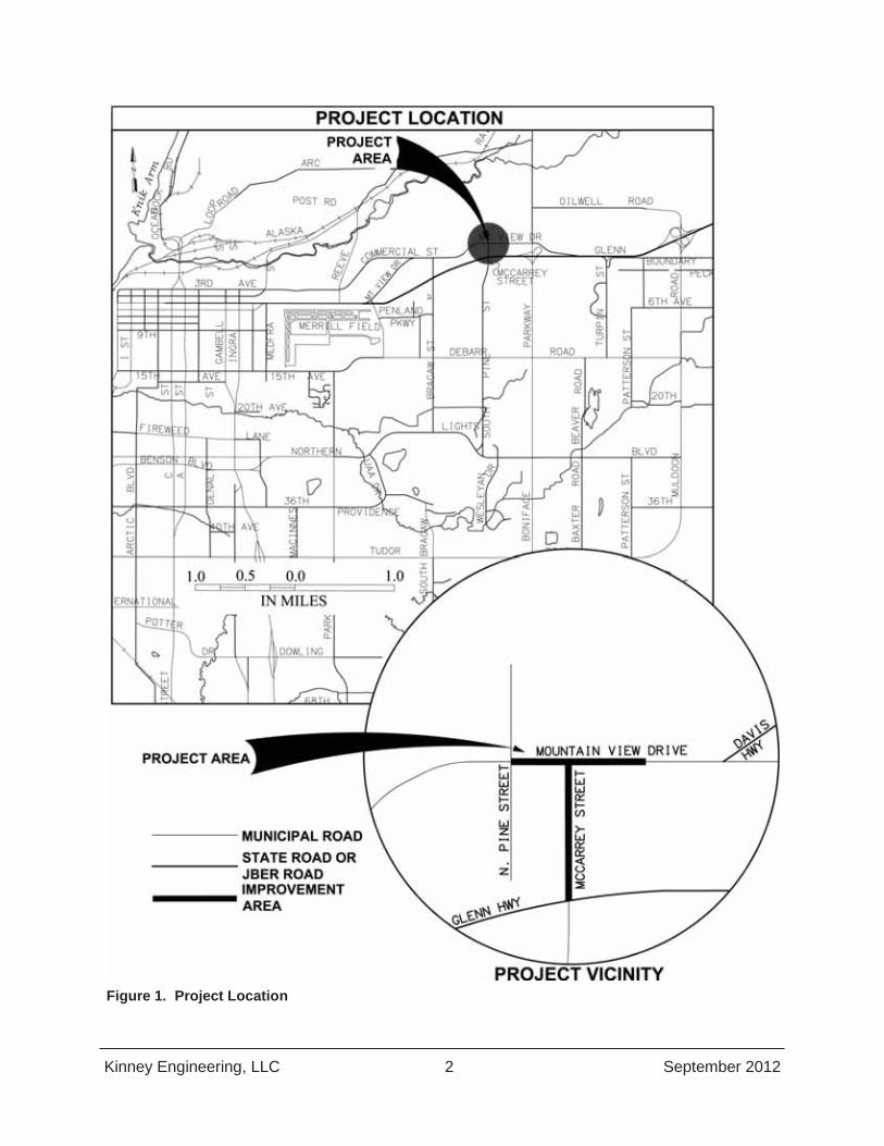
1. INTRODUCTION The Municipality of Anchorage’s (MOA) Project Management & Engineering Division (PM&E) of the Department of Public Works has contracted with Kinney Engineering, LLC to design roadway and pedestrian safety improvements at the intersection of Mountain View Drive and McCarrey Street. The construction year for this project is expected to be 2014 and the design year is 2034, for a design life of 20 years.
1.1 General and Project Location Mountain View Drive and McCarrey Street are located in the Mountain View neighborhood in northeast Anchorage. Mountain View Drive serves as the main corridor for the commercial and residential areas through the neighborhood, and as well as a secondary route to downtown Anchorage for drivers who would otherwise use the Glenn Highway. McCarrey Street links the high density Wonder Park neighborhood south of the Glenn Highway to Mountain View Drive. McCarrey Street has a grade-separated crossing of the Glenn Highway, without any access to or from the Glenn Highway.
The project area is bounded on the north by Davis Park, on the south by the Glenn Highway ROW, on the west by North Pine Street, and on the east by the Davis Highway.
The Mountain View Drive/McCarrey Street intersection serves several neighborhoods, schools and local parks in the northeast area of Anchorage. See Figure 1 for an overview of the project area.
1.2 Purpose This project will evaluate alternatives to upgrade the intersection to improve pedestrian and vehicle safety and traffic capacity. Improvements are anticipated to include new pavement, channelization, traffic control, pedestrian/bicycle facilities, landscaping, and street lighting.
The goals of this project are to:
Reduce traffic congestion at the intersection.
Improve safety by providing pedestrian facilities to separate pedestrians and bicycles from vehicle traffic.
Kinney Engineering, LLC 2 September 2012
Figure 1. Project Location

Kinney Engineering, LLC 3 September 2012
1.3 Need This project is needed for capacity improvements and for safety improvements. The north bound left turn lane of McCarrey Street, currently under stop sign control, operates at a level of service (LOS) D in the peak hour, and is forecasted to operate at a LOS F by the design year (2034). There were 28 crashes at this intersection over 10 years, yielding a higher than average crash rate, but at 85% of the upper control limit (UCL) rate. The UCL will typically be a threshold to determine unusually high levels of crashes. Pedestrian –vehicle crashes at this location were at 7% of the total, but about seven times the overall pedestrian crashes percentage within the MOA. As such, pedestrian crashes are statistically significant as highly overrepresented at this location when compared to other intersections in the Municipality. The high frequency of the crash type indicates that these occurrences were not likely due solely to chance, and therefore have underlying contributing factors.
2. HISTORY This intersection in its current configuration, was constructed from 1986 to 1988 as part of a larger DOT&PF construction project that built the Boniface Interchange and overpass. Access to McCarrey Street from the Glenn Highway was removed and Mountain View Drive extended east from Pine Street along portions of the former Davis Highway alignment, to connect to Boniface Parkway north of the Glenn Highway. Minor re-striping projects occurred in 1996 and 2001, with re-surfacing repairs on Mountain View Drive occurring in 2001. The Mountain View Drive Pedestrian Improvements project constructed in 2011 added a pathway and landscaping elements on the south side of Mountain View Drive from Pine Street to McCarrey Street.
This intersection project is a high priority for the Mountain View Community Council, and is the number 3 project on their 2012 Capital Project Priority List. The project is prioritized as such as it will provide safety and enhance circulation for both vehicles and pedestrians.
This project is currently funded with local road bonds through the design study phase. State grant funding will likely be used for the design and construction phases.
3. EXISTING CONDITIONS
3.1 Facility Description Mountain View Drive is an east-west Class 1A Industrial/Commercial Collector that is the neighborhood’s main street. It has two 12-foot wide, paved travel lanes and a two-way-center-turn lane west of the intersection with McCarrey Street. On the east side of the intersection, there is a dedicated westbound left turn lane. The posted speed on Mountain View Drive is 30 mph west of McCarrey Street and 45 mph east of McCarrey Street. Mountain View Drive has pedestrian facilities on the north side and pedestrian facilities on the south side of the roadway, except east of McCarrey Street where there are none. There is existing street lighting on Mountain View Drive. The closest traffic signal is at North Lane Street, two blocks west of the intersection.

Kinney Engineering, LLC 4 September 2012
McCarrey Street is a north-south Class 1 Collector that terminates at a T-intersection with Mountain View Drive. McCarrey Street south of the intersection transitions into a bridge above the Glenn Highway and connects with the Wonder Park neighborhood. At the intersection approach, McCarrey Street has three existing 11-foot wide, paved lanes (southbound, northbound left-turn lane, northbound right-turn lane), striped shoulders, with curb and attached. The curb and sidewalk on the west side of the street begins 100 feet south of the intersection and terminates at the bridge. The attached sidewalk on the east side of McCarrey originates at the intersection with Mountain View Drive and continues south across the Glenn Highway overpass. The posted speed limit on McCarrey Street is 30 mph. There is existing street lighting on the west side of McCarrey Street and a storm drain catch basin near the intersection with Mountain View Drive.
3.2 Land Use, Context and Setting Mountain View is a neighborhood with diversity in housing types, residential densities, commercial businesses and cultural activities. The area is bound by Joint Base Elmendorf-Richardson (JBER) to the north, Boniface Parkway to the east, the Glenn Highway to the south and the Ship Creek area to the west. Single family dwellings are mixed with residential duplexes, four-plexes, and larger multi-family complexes. Mountain View Drive traverses the area in a mostly east-west direction and is recognized as the “main street” and commercial heart of the community. The neighborhood developed in a grid pattern and connectivity is good between the residential and commercial areas. The Mountain View commercial district includes a mix of ethnic restaurants, businesses, and non-profits such as the Anchorage Community Land Trust (see Figure 2).
Zoning adjacent to (north, south, and east) the project area is Transition Zoning, “T”, which are lands that are not developing, or not expected to develop due to their current condition, or relationship with other nearby development. In this case, the lands are parks; land owned by the United States Air Force (USAF) on Joint Base Elmendorf and Richardson, and road rights-of-way. Other nearby zoning adjacent to the project area are Commercial B-3 (General Business) zoned parcels to the west on lots fronting Mountain View Drive, with Residential R-2M, and R-3 (Multi-Family) zoning areas to the north and south of the commercial properties along Mountain View Drive.

Kinney Engineering, LLC 5 September 2012
Figure 2. Land Use and Zoning
The area is served by public water and sewer and has all other utility services including telephone, cable, gas, and electric.
School-aged children in the area attend Mountain View or Tyson Elementary. The Middle School for the area is Clark Middle School. The Mountain View area is served by both East High School and Bartlett High School. Mountain View Drive and McCarrey Street in the project area are not designated by the MOA as Safe Routes to School. Other local roads in the neighborhood are the preferred walking routes to school. Mountain View Drive does have two preferred crossing locations for Clark Middle School students. The closest one to the intersection is between North Lane Street and Bunn Street. The other preferred crossing route is between Klevin and Flower Streets. Elementary school and middle school children in the area are not bussed. High school students attending either East High School or Bartlett High School have bus service.
Davis Park and Mountain View Lions Club Community Park are both community use parks and home to the Polar Little League and the Alaska Oosik Rugby Union. Park amenities include picnic shelters, benches, basketball courts, baseball fields, children’s play equipment, open grass fields, rugby fields, and a parking lot.
Kinney Engineering, LLC 6 September 2012
The MOA leases the property in the southeast quadrant of the Mountain View / McCarrey intersection from the US Government (JBER) and utilizes the land as a snow disposal site.
Vegetation near the intersection of McCarrey Street and Mountain View Drive includes a mix of birch, alder, poplar, and cottonwoods.
3.3 Pedestrian and Non-Motorized Facilities Mountain View Drive has a separated 8-foot pathway on the north side of the road. This pathway is part of the link between the Glenn Highway pathway and the Ship Creek Trail and to other routes through the Mountain View Neighborhood and west to Downtown Anchorage. This section of pathway also links the Glenn Highway pathway (via McCarrey Street) to pedestrian and non-motorized facilities on the south side of the Glenn Highway, such as along South Pine Street and beyond to Russian Jack Springs Park and the Chester Creek Trail.
The south side of Mountain View Drive has no developed pedestrian or non-motorized facilities east of McCarrey Street. West of McCarrey Street, a new 8-foot paved pathway separated from the roadway by a 15-foot landscaped buffer extends eastward from North Pine Street, arching across DOT&PF right-of-way southward to connect to the west side of McCarrey Street. This new pathway transitions to a 5-foot wide concrete sidewalk along McCarrey Street midway to the Glenn Highway overpass. At the overpass, the curb, gutter, and sidewalk transition into a 7 foot striped shoulder.
Between Mountain View Drive and the Glenn Highway overpass, McCarrey Street has paved and striped shoulders on both sides and a continuous attached 6-foot asphalt sidewalk on the east side.
There are no designated pedestrian crossings at McCarrey Street or Mountain View Drive within the project area.
3.4 Landscape The existing landscape within the project corridor varies. Within the majority of the Mountain View Drive and McCarrey Street ROW, areas that are not roadway or pathway consist of grass and gravel, with the ditch line/buffer on the north side of Mountain View Drive well vegetated with grass. Between North Pine Street and McCarrey Street, along the south side of Mountain View Drive, there are natural trees and brush, and newly installed (2011) birch trees and landscaping boulders. A decorative wood post and chain vehicle barrier separates the pathway from Davis Park along the north side of Mountain View Drive. This fence projects to the north and east around the gravel parking area adjacent to Davis Park. Undeveloped or undisturbed areas in the DOT&PF ROW and on USAF land are a mix of birch, alder, poplar, cottonwood, and spruce trees with natural brushy plants at the forest edges and openings.
3.5 Drainage Topography is relatively flat at the intersection within the ROW, with the ground sloping gently to the south and west. McCarrey Street is constructed on top of a roadway embankment that has been built up to connect to Glenn Highway overpass. The grade along McCarrey Street itself slopes gently downhill north from the overpass to the intersection. This site is down-gradient of

Kinney Engineering, LLC 7 September 2012
the intersection, and it slopes south towards the Glenn Highway ROW. Curb and gutter contains runoff from McCarrey Street, directing it northward to the low point along the McCarrey Street alignment 50 feet south of the intersection with Mountain View Drive. On the east side of McCarrey Street, a catch basin collects this runoff and transports it to the toe of the road embankment through a 24-inch corrugated metal pipe culvert. On the west side of McCarrey Street, the curb terminates prior to Mountain View Drive and the storm runoff flows west into the vegetated buffer and flows southwest.
The east-west ditch line on the north side of Mountain View Drive collects runoff from paved roadway surface and from Davis Park. The ditch line slopes west at a shallow (0.5 percent) slope to North Pine Street, where it crosses south under Mountain View Drive in an 18-inch culvert pipe. The culvert terminates south of Mountain View Drive, where runoff currently infiltrates in native soil and vegetation, as the outlet end of the pipe has been buried with approximately 3 feet of compacted fill.
There are no known flooding issues at this location. However, most of the culvert pipes in the project vicinity are partially, if not fully blocked with grass, road sand and sediment deposits. Their current condition does not appear to adversely affect or create drainage problems in the project area. At the Agency Scoping Meeting for the Concept Report for this project, MOA Street Maintenance stated that they have no maintenance problems or issues in the project area.
3.6 Utilities There are numerous overhead and underground utilities in and adjacent to the intersection of Mountain View Drive and McCarrey Street. Below is an overview of the existing utilities in the project area and project vicinity.
3.6.1 Natural gas (ENSTAR) There are no known natural gas distribution facilities within the anticipated footprint of this project. The closest ENSTAR facility to the project is a service line that feeds the Hula Hands Restaurant from the alley one block south of Mountain View Drive west of North Pine Street.
3.6.2 Sewer (AWWU) There are no known AWWU sewer facilities within the anticipated footprint of this project. The nearest AWWU sewer lines are to the west of the project area, one block north, and one block south of Mountain View Drive on North Pine Street.
3.6.3 Water (AWWU) The 42-inch diameter concrete pipe serving Anchorage from the water treatment facility at Eklutna Lake extends under our project footprint along the north side of Mountain View Drive. At the intersection of Mountain View Drive and North Pine Street, the water main turns and extends to the south. A 6-inch asbestos concrete and 12-inch ductile iron pipes extend north up North Pine Street. An 8-inch asbestos concrete pipe extends southward on North Pine Street from Mountain View Drive.

Kinney Engineering, LLC 8 September 2012
At the Davis Park driveway opposite the Mountain View / McCarrey intersection, a 12-inch cast iron (CI) pipe branches off the 42-inch transmission main and extends westward toward North Pine Street, paralleling the 42-inch main by approximately 12 feet.
AWWU as-built documents show average burial depth of their facilities to be 9.5 to 10 feet below ground surface. The centerline of the water main is approximately 2 feet south of the north edge of the 8 foot pedestrian pathway on the north side of Mountain View Drive.
A water valve vault (AWWU No. 8) is located in the southeast corner of the intersection of North Pine Street and Mountain View Drive.
3.6.4 Electric (ML&P) Municipal Light & Power (ML&P) has facilities in the project area. A 12.47 kV overhead power line extends along the east side of McCarrey Street from the Glenn Highway northward to where it crosses Mountain View Drive. This overhead line then makes a 90 degree directional change at a wooden power pole with two guy line anchors and extends east along the north side of Mountain View Drive and beyond the anticipated project limit. Another ML&P facility, an 115 kV overhead line crosses McCarrey Street just south of the MOA snow disposal site driveway. This overhead line extends west to North Pine Street, then branches north and crosses Mountain View Drive at North Pine Street.
3.6.5 Storm Drain (MOA, DOT&PF) The closest MOA piped storm drain system is to the northwest of the Mountain View / McCarrey intersection on North Pine Street. The east side of McCarrey Street (DOT&PF) has curb and gutter with attached sidewalk. A catch basin is located in the southeast quadrant of the intersection on the east side of McCarrey Street. A 24-inch corrugated metal pipe extends east from this catch basin to the bottom of the roadway embankment where it terminates in thick vegetation and natural forest where a MOA snow disposal site is located.
3.6.6 Communications (Telephone, Cable Television) GCI, ACS There are no known telephone or cable television (GCI or ACS) facilities within the proposed footprint for our project. The nearest communications facilities feed the neighborhoods to the north and south of Mountain View Drive and west of North Pine Street from beyond the west edge of the project area.
3.7 Public Transportation People Mover Route 45 travels through the intersection of Mountain View Drive and McCarrey Street. The route begins downtown, travels east on Mountain View Drive, then south at McCarrey Street. After travelling through the UMED district to Tudor Road, the route returns north up McCarrey Street, then travels west on Mountain View Drive. There are two existing bus stops west of the Mountain View / McCarrey Street intersection which average 60 or more riders per day. Ridership on this route is the highest of the entire system, with busses’ headway at 30 minutes.

Kinney Engineering, LLC 9 September 2012
4. Existing Traffic Conditions Mountain View Drive is a major collector for the Mountain View neighborhood, connecting to the Glenn Highway off-ramp at Boniface Road to the east and connecting with the Glenn Highway at a signalized intersection to the west. At McCarrey Street, the cross-section of Mountain View Drive is characterized as rural-type section, with paved or gravel shoulders, and ditches. Just west of McCarrey, at Pine Street, Mountain View Drive transitions to an urbanized cross-section with a center two-way-left-turn lane, curb and gutter, and attached sidewalks. McCarrey Street connects the Wonder Park neighborhood south of the Glenn Highway to Mountain View with a grade-separated crossing of the Glenn Highway. Davis Park, on the north side of the T-intersection, is a pedestrian generator with sports fields, picnic facilities, and a community garden.
4.1 Existing Volumes
4.1.1 Average Annual Daily Traffic Annual Average Daily Traffic (AADT) for each leg of the study intersection was taken from the DOT&PF Central Region Annual Traffic Reports. Figure 3 shows historical AADTs from the last twelve years. The average over the last five years is 10,500 vehicles per day (vpd) on Mountain View Drive west of the intersection, 8,700 vpd on Mountain View Drive east of the intersection, and 4,000 vpd on McCarrey Street.
Figure 3. Historical AADTs for Mountain View Drive and McCarrey Street
0
2000
4000
6000
8000
10000
12000
14000
16000
1998 2000 2002 2004 2006 2008 2010 2012
Annu
al A
vera
ge D
aily
Tra
ffic
(veh
icles
per
day
)
Year
Mountain View Drive: Bragaw Street to McCarrey Street
Mountain View Drive: McCarrey Street to Boniface Road
McCarrey Street: Mountain View Drive south to Pine Street

Kinney Engineering, LLC 10 September 2012
4.1.2 Peak Hour Turning Movements Turning movement data was collected at the intersection during several weekdays in May 2012. The peak hour volumes in the morning, mid-day, and evening are shown in Figure 4 through Figure 6 below. As the counts indicate, the prevalent direction of travel on Mountain View Drive is westbound in the morning and eastbound in the evening, consistent with commuting traffic patterns. On the other hand, traffic volumes onto and off of McCarrey Street are fairly consistent throughout the day.
Figure 4. Morning Peak Hour Turning Movement Counts (May 2012)

Kinney Engineering, LLC 11 September 2012
Figure 5. Mid-day Peak Hour Turning Movement Counts (May 2012)
Figure 6. Evening Peak Hour Turning Movement Counts (May 2012)
4.1.3 Pedestrian and Bicycle Counts Safely accommodating pedestrian and bicycle traffic at this intersection is one of the main goals of this project. As such, pedestrian counts were conducted at the intersection and also along pedestrian shortcuts near the intersection. Figure 7 shows the major pedestrian routes in the study area.

Kinney Engineering, LLC 12 September 2012
Pedestrians crossing the Glenn Highway on the McCarrey Street bridge take one of three routes to get between Mountain View Drive and McCarrey Street: they go to the intersection of McCarrey Street with Mountain View Drive, they use the paved pathway that cuts off a corner between McCarrey Street and Mountain View Drive, or they cross through the empty lot on the southwest corner of the intersection along an unpaved pedestrian pathway. To cross Mountain View Drive, pedestrians could cross at the nearest signalized crossing at Lane Street, about ¼ mile from McCarrey Street; however, many pedestrians cross Mountain View Drive at unsignalized locations prior to the Lane Street signal. The pathway on the north side of the Mountain View Drive/McCarrey Street intersection connects the Glenn Highway shared use pathway with the Ship Creek shared use pathway via the Mountain View neighborhood.
Counts of pedestrians and bicyclists were taken from 5 AM until 10 PM on a weekday in early May. There were four peak periods for pedestrian and bicycle volumes: morning (7:15 AM to 8:15 AM), mid-day (1:45 PM to 2:45 PM), evening (4:45 PM to 5:45 PM), and later evening (7:15 PM to 8:15 PM). The observed volumes for each of these periods are shown in Figure 8 through Figure 11.

13
Figure 7. Pedestrian Routes in Study Area

Mountain View Drive / McCarrey Street Intersection & Safety Upgrades Project No. 10-012 Draft Design Study Report
Kinney Engineering, LLC 14 September 2012
Figure 8. Morning Peak Hour Pedestrian and Bicycle Counts (May 2012)
Figure 9. Mid-day Peak Hour Pedestrian and Bicycle Counts

Mountain View Drive / McCarrey Street Intersection & Safety Upgrades Project No. 10-012 Draft Design Study Report
Kinney Engineering, LLC 15 September 2012
Figure 10. Evening Peak Hour Pedestrian and Bicycle Counts (May 2012)
Figure 11. Late Evening Peak Hour Pedestrian and Bicycle Counts (May 2012)
Mountain View Drive / McCarrey Street Intersection & Safety Upgrades Project No. 10-012 Draft Design Study Report
Kinney Engineering, LLC 16 September 2012
4.2 Speeds The speed limit on Mountain View Drive changes at McCarrey Street as Mountain View Drive transitions from a rural cross-section to an urbanized cross-section. East of McCarrey Street, the speed limit is 45 mph. West of McCarrey Street, the speed limit is 30 mph. A spot speed study was performed on Mountain View Drive in each of these speed zones. The spot speed study was performed in March 2012 under dry pavement conditions. The 85th percentile speed for eastbound traffic was found to be 38 mph west of McCarrey Street (in the 30 mph speed zone) and 42 mph east of McCarrey Street (in the 45 mph speed zone). The 85th percentile speed for westbound traffic, on the other hand, was found to be 44 mph east of McCarrey Street (in the 45 mph speed zone) and 38 mph west of McCarrey Street (in the 30 mph speed zone).
Thus, traffic was generally traveling at or just below the speed limit in the 45 mph speed zone area, but was generally traveling above the speed limit in the 30 mph speed zone area. Since vehicle speed directly impacts pedestrian safety and speeding in this area is one of the concerns expressed by the public, possible effects of different alternatives on speeding should be considered as part of the evaluation of each alternative.
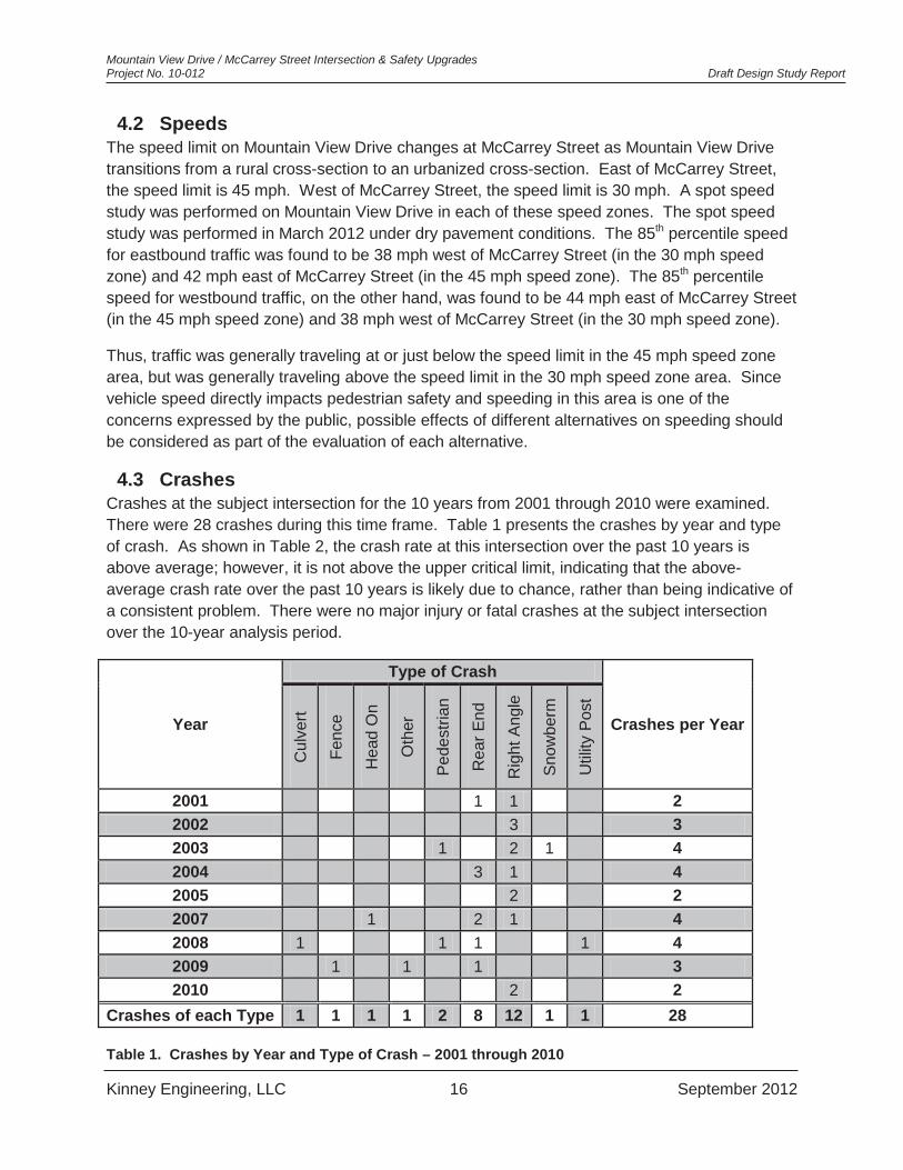
4.3 Crashes Crashes at the subject intersection for the 10 years from 2001 through 2010 were examined. There were 28 crashes during this time frame. Table 1 presents the crashes by year and type of crash. As shown in Table 2, the crash rate at this intersection over the past 10 years is above average; however, it is not above the upper critical limit, indicating that the above-average crash rate over the past 10 years is likely due to chance, rather than being indicative of a consistent problem. There were no major injury or fatal crashes at the subject intersection over the 10-year analysis period.
Year
Type of Crash
Crashes per Year
Cul
vert
Fenc
e
Hea
d O
n
Oth
er
Pede
stria
n
Rea
r End
Rig
ht A
ngle
Snow
berm
Util
ity P
ost
2001 1 1 2 2002 3 3 2003 1 2 1 4 2004 3 1 4 2005 2 2 2007 1 2 1 4 2008 1 1 1 1 4 2009 1 1 1 3 2010 2 2
Crashes of each Type 1 1 1 1 2 8 12 1 1 28
Table 1. Crashes by Year and Type of Crash – 2001 through 2010

Mountain View Drive / McCarrey Street Intersection & Safety Upgrades Project No. 10-012 Draft Design Study Report
Kinney Engineering, LLC 17 September 2012
Intersection Crashes 2001 to
2010
Average Entering
AADT 2001 to
2010
Million Entering Vehicles
(MEV)
Crashes / MEV Control State
Populations
Upper Critical
Limit (LCL) @ 95.00%
Confidence
Above Average?
Above Critical?
Safety Index
Rate/UCL
28 12,473 45.528 0.615 STOP 0.535 0.724 YES NO 0.85 Table 2. Intersection Crash Rate – 2001 through 2010
Pedestrian safety is of particular interest for this project. There were two pedestrian-vehicle crashes during the 10-year analysis period, such that the percentage of pedestrian crashes at this location, 7%, is higher than the average percentage of pedestrian crashes at other intersections in Anchorage on the whole (around 1%). As such, a hypothesis test provides statistical evidence that the pedestrian -vehicle crashes here are highly overrepresented when compared to other areas in Anchorage, and the higher incidence may not be solely by chance. As such, there are likely contributing factors that have causal effects on the crashes.
One of the pedestrian crashes occurred in October 2003 when an inebriated pedestrian was struck by a pick-up truck late in the evening under foggy conditions. The pedestrian received only minor injuries. The second pedestrian crash occurred in May 2008 when an inebriated pedestrian was struck by an inebriated 24 year-old male driving a SUV early in the morning while it was still dark. The pedestrian and the driver received only minor injuries.
Alcohol appears to be the common contributing factor at this location for the pedestrian –vehicle collisions. However, other contributing factors include:
Mountain View residents have a very high proportion of walkers and transit users among them.
o Anecdotally, it has been reported by residents and business that 70% of the community does not own private vehicles.
o Peoplemover’s Route 45 serves this area and their staff reports that it is the highest ridership in the system.
o As such, there is increase in risk of collisions along with the increase in pedestrian activity.
Presently the intersection has no pedestrian crossing controls. Pedestrians must select gaps in two-way, moderate speed traffic to cross three lanes.
o Gaps are increasingly difficult to judge with higher volumes, speeds, low light levels and when inebriation is involved. Current pedestrian level of service is very poor (discussed below), which indicates high likelihood of taking risks and using inadequate gaps to cross.
o Pedestrians observed darting out to cross Mountain View. o All of the build alternatives proposed will provide some measures or control or
reduce exposure for crossing pedestrians.
4.4 Capacity Analyses The intersection of Mountain View Drive with McCarrey Street is a two-way stop controlled T-intersection, with stop control on McCarrey Street. As such, eastbound and westbound vehicles and pedestrian traffic are free-flowing and are not delayed at the intersection.
Mountain View Drive / McCarrey Street Intersection & Safety Upgrades Project No. 10-012 Draft Design Study Report
Kinney Engineering, LLC 18 September 2012
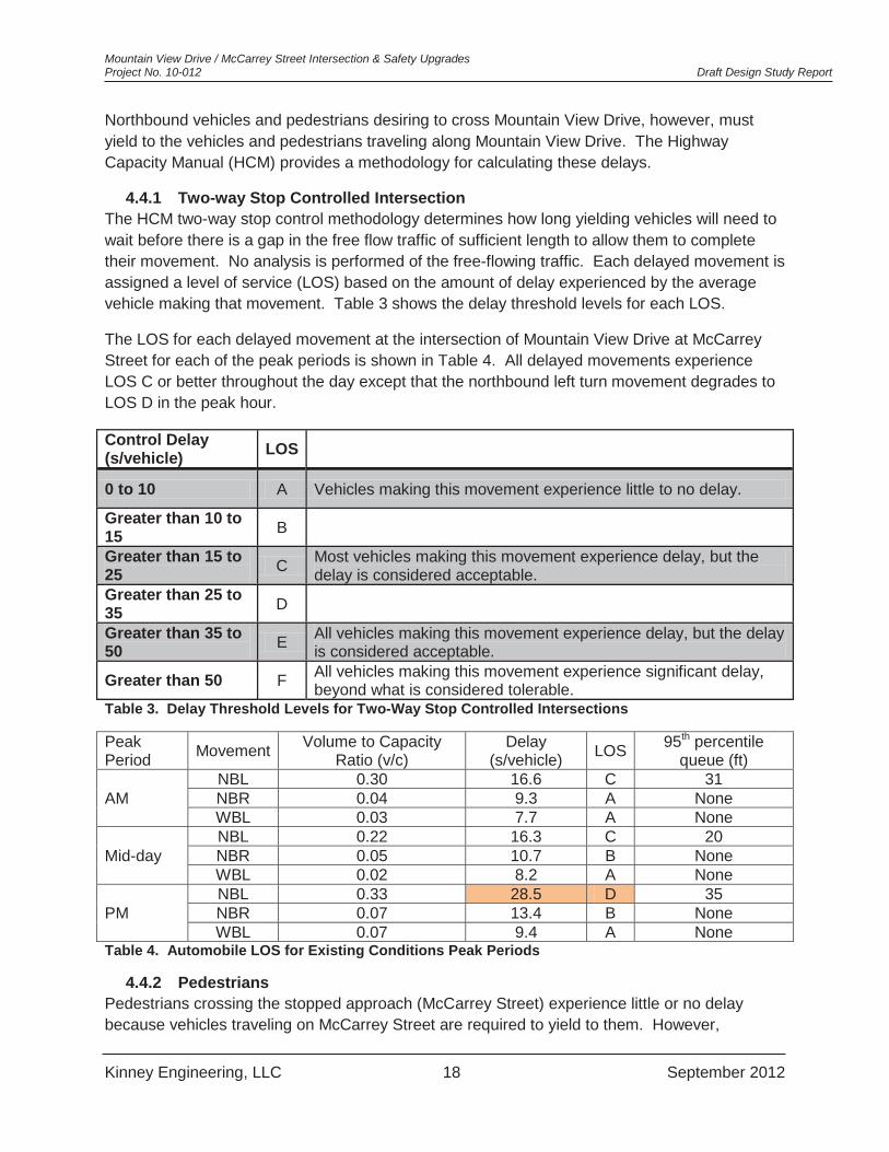
Northbound vehicles and pedestrians desiring to cross Mountain View Drive, however, must yield to the vehicles and pedestrians traveling along Mountain View Drive. The Highway Capacity Manual (HCM) provides a methodology for calculating these delays.
4.4.1 Two-way Stop Controlled Intersection The HCM two-way stop control methodology determines how long yielding vehicles will need to wait before there is a gap in the free flow traffic of sufficient length to allow them to complete their movement. No analysis is performed of the free-flowing traffic. Each delayed movement is assigned a level of service (LOS) based on the amount of delay experienced by the average vehicle making that movement. Table 3 shows the delay threshold levels for each LOS.
The LOS for each delayed movement at the intersection of Mountain View Drive at McCarrey Street for each of the peak periods is shown in Table 4. All delayed movements experience LOS C or better throughout the day except that the northbound left turn movement degrades to LOS D in the peak hour.
Control Delay (s/vehicle) LOS
0 to 10 A Vehicles making this movement experience little to no delay.
Greater than 10 to 15 B
Greater than 15 to 25 C Most vehicles making this movement experience delay, but the
delay is considered acceptable. Greater than 25 to 35 D
Greater than 35 to 50 E All vehicles making this movement experience delay, but the delay
is considered acceptable.
Greater than 50 F All vehicles making this movement experience significant delay, beyond what is considered tolerable.
Table 3. Delay Threshold Levels for Two-Way Stop Controlled Intersections
Peak Period Movement Volume to Capacity
Ratio (v/c) Delay
(s/vehicle) LOS 95th percentile queue (ft)
AM NBL 0.30 16.6 C 31 NBR 0.04 9.3 A None WBL 0.03 7.7 A None
Mid-day NBL 0.22 16.3 C 20 NBR 0.05 10.7 B None WBL 0.02 8.2 A None
PM NBL 0.33 28.5 D 35 NBR 0.07 13.4 B None WBL 0.07 9.4 A None
Table 4. Automobile LOS for Existing Conditions Peak Periods
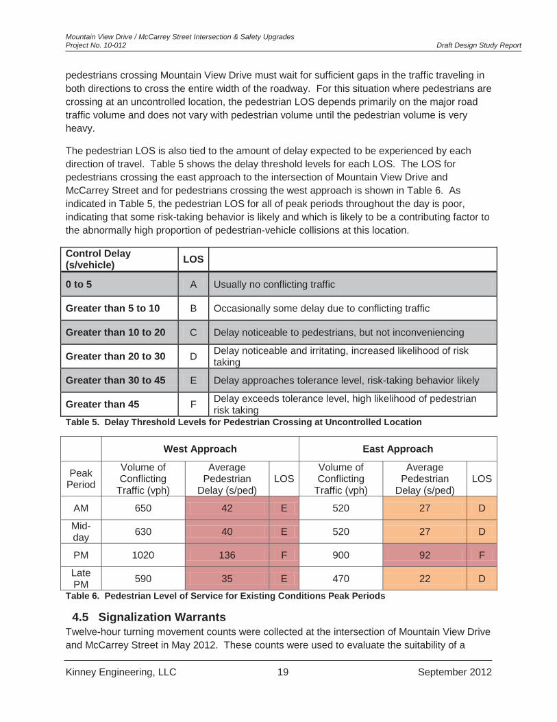
4.4.2 Pedestrians Pedestrians crossing the stopped approach (McCarrey Street) experience little or no delay because vehicles traveling on McCarrey Street are required to yield to them. However,
Mountain View Drive / McCarrey Street Intersection & Safety Upgrades Project No. 10-012 Draft Design Study Report
Kinney Engineering, LLC 19 September 2012
pedestrians crossing Mountain View Drive must wait for sufficient gaps in the traffic traveling in both directions to cross the entire width of the roadway. For this situation where pedestrians are crossing at an uncontrolled location, the pedestrian LOS depends primarily on the major road traffic volume and does not vary with pedestrian volume until the pedestrian volume is very heavy.
The pedestrian LOS is also tied to the amount of delay expected to be experienced by each direction of travel. Table 5 shows the delay threshold levels for each LOS. The LOS for pedestrians crossing the east approach to the intersection of Mountain View Drive and McCarrey Street and for pedestrians crossing the west approach is shown in Table 6. As indicated in Table 5, the pedestrian LOS for all of peak periods throughout the day is poor, indicating that some risk-taking behavior is likely and which is likely to be a contributing factor to the abnormally high proportion of pedestrian-vehicle collisions at this location.
Control Delay (s/vehicle) LOS
0 to 5 A Usually no conflicting traffic
Greater than 5 to 10 B Occasionally some delay due to conflicting traffic
Greater than 10 to 20 C Delay noticeable to pedestrians, but not inconveniencing
Greater than 20 to 30 D Delay noticeable and irritating, increased likelihood of risk taking
Greater than 30 to 45 E Delay approaches tolerance level, risk-taking behavior likely
Greater than 45 F Delay exceeds tolerance level, high likelihood of pedestrian risk taking
Table 5. Delay Threshold Levels for Pedestrian Crossing at Uncontrolled Location
West Approach East Approach
Peak Period
Volume of Conflicting
Traffic (vph)
Average Pedestrian
Delay (s/ped) LOS
Volume of Conflicting
Traffic (vph)
Average Pedestrian
Delay (s/ped) LOS
AM 650 42 E 520 27 D
Mid-day 630 40 E 520 27 D
PM 1020 136 F 900 92 F
Late PM 590 35 E 470 22 D
Table 6. Pedestrian Level of Service for Existing Conditions Peak Periods
4.5 Signalization Warrants Twelve-hour turning movement counts were collected at the intersection of Mountain View Drive and McCarrey Street in May 2012. These counts were used to evaluate the suitability of a

Mountain View Drive / McCarrey Street Intersection & Safety Upgrades Project No. 10-012 Draft Design Study Report
Kinney Engineering, LLC 20 September 2012
signal at this location according to the signal warrants found in the Manual of Uniform Traffic Control Devices (MUTCD). Different volume threshold levels are applied for many of the warrants depending upon the 85th percentile speed of the traffic on the major street. If the 85th percentile speed is above 40 mph, the volume threshold level is reduced. At the study location, it is known that the 85th percentile speed on the eastbound approach is 38 mph (< 40 mph) and the 85th percentile speed on the westbound approach is 42 to 44 mph (> 40 mph). If the 85th percentile speed of 38 mph is used, then no signal warrants are met at this intersection. If the 85th percentile speed of 42 to 44 mph is used, then Warrant 2, Four-Hour Vehicular Volume is met for the four hours from 3 PM to 7 PM. Table 7 shows how each warrant is evaluated under the two scenarios.
A signal can be one of the options considered for this intersection, but other options should also be explored.

Mountain View Drive / McCarrey Street Intersection & Safety Upgrades Project No. 10-012 Draft Design Study Report
Kinney Engineering, LLC 21 September 2012
MUTCD Warrant Criteria Warrant met for 38 mph 85th percentile speed?
Warrant met for 42 to 44 mph 85th percentile speed?
Warrant 1- 8-Hour Vehicular Volume, Condition A- Minimum Vehicular Volume
8 hours with major road and minor road volumes above thresholds
No, 0 hours meet the volume thresholds
No, 2 hours meet the volume thresholds
Warrant 1- 8-Hour Vehicular Volume, Condition B- Interruption of Continuous Traffic
8 hours with major road and minor road volumes above thresholds
No, 4 hours meet the volume thresholds
No, 7 hours meet the volume thresholds
Warrant 1- 8-Hour Vehicular Volume, Combination of A&B
8 hours with major road and minor road volumes above thresholds
No, 1 hour meets the volume thresholds
No, 5 hours meet the volume thresholds
Warrant 2- 4-Hour Vehicular Volume
4 hours with major road and minor road volumes above thresholds
No, 0 hours meet the volume thresholds
Yes, 4 hours meet the volume thresholds
Warrant 3- Peak Hour Volume
1 hour with major road and minor road volumes above thresholds
No, 0 hours meet the volume thresholds
No, 0 hours meet the volume thresholds
Warrant 4- Pedestrian Volume, Condition A
4 hours with major road and pedestrian volumes above thresholds
No, 0 hours meet the volume thresholds
No, 0 hours meet the volume thresholds
Warrant 4- Pedestrian Volume, Condition B
1 hour with major road and pedestrian volumes above thresholds
No, 0 hours meet the volume thresholds
No, 0 hours meet the volume thresholds
Warrant 5- School Crossing
Not Applicable
Warrant 6- Coordinated Signal System
Not Applicable
Warrant 7- Crash Experience
5 correctable crashes in a 12 month period and 8 hours above volume thresholds
No, there were only 3 correctable crashes and only 4 hours meet the volume thresholds
No, there were only 3 correctable crashes, but 10 hours meet the volume thresholds
Warrant 8- Roadway Network
Intersection of two major routes with volumes projected to meet warrants 1, 2, or 3 within 5 years
No, volume thresholds are not met in 5 years
Yes, if McCarrey Street is considered a major route (not a strong warrant for this location)
Table 7. Signal Warrant Evaluation
Mountain View Drive / McCarrey Street Intersection & Safety Upgrades Project No. 10-012 Draft Design Study Report
Kinney Engineering, LLC 22 September 2012
5. TRAFFIC FORECASTS
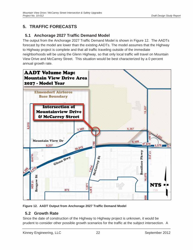
5.1 Anchorage 2027 Traffic Demand Model The output from the Anchorage 2027 Traffic Demand Model is shown in Figure 12. The AADTs forecast by the model are lower than the existing AADTs. The model assumes that the Highway to Highway project is complete and that all traffic traveling outside of the immediate neighborhoods will be using the Glenn Highway, so that only local traffic will travel on Mountain View Drive and McCarrey Street. This situation would be best characterized by a 0 percent annual growth rate.
Figure 12. AADT Output from Anchorage 2027 Traffic Demand Model
5.2 Growth Rate Since the date of construction of the Highway to Highway project is unknown, it would be prudent to consider other possible growth scenarios for the traffic at the subject intersection. A

Mountain View Drive / McCarrey Street Intersection & Safety Upgrades Project No. 10-012 Draft Design Study Report
Kinney Engineering, LLC 23 September 2012
projected traffic volume growth rate for Anchorage was developed by examining the relationship between historical population and traffic volumes in the Anchorage Bowl. Figure 13 plots population growth from 1997 to 2009 and traffic volume over the same period. The traffic volume is the sum of the AADTs for several Permanent Traffic Recorder locations around Anchorage. As can be seen in the figure, traffic trends upward with population. A regression equation was developed for this relationship and was used to forecast the traffic volume from 2010 to 2035 using population forecasts for the Municipality of Anchorage from the Alaska Department of Labor and Workforce Development. Using this methodology, the annual projected forecast was 0.5 percent. A conservative design growth rate based on this analysis would be 1 percent.
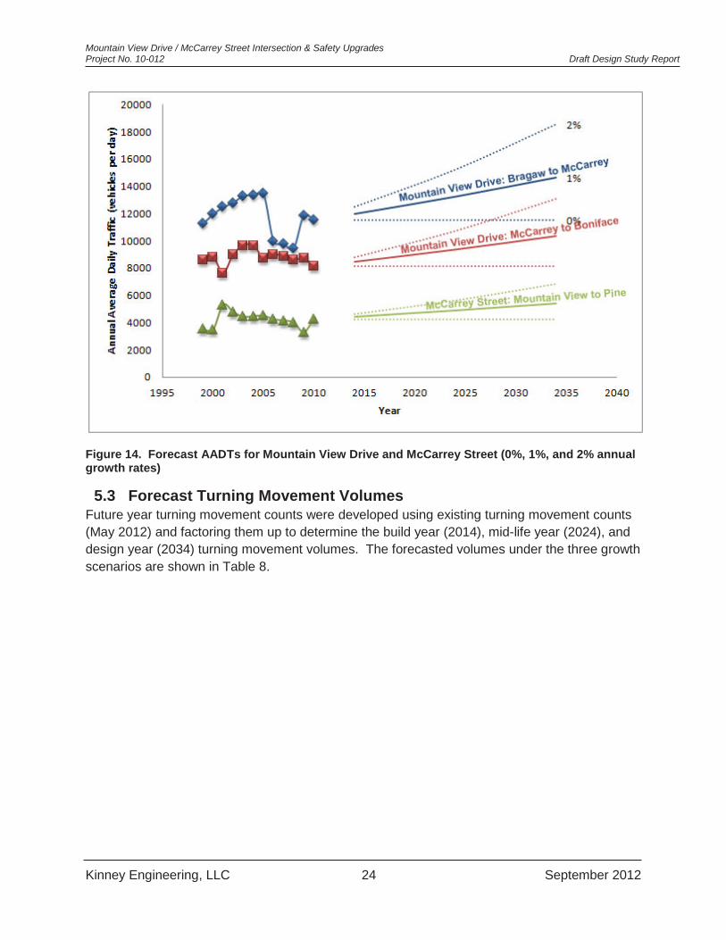
Looking at Figure 13, it is apparent that traffic has recently begun to trend less with population than it did in the past. Thus, it is prudent to evaluate each of the possible alternatives under a range of growth rates to determine how sensitive the results are to the chosen growth rate. Consequently, in addition to the 0 percent growth rate suggested by the Anchorage 2027 traffic demand model, traffic forecasts were made based on growth rates of 1 and 2 percent. Figure 14 shows the historical AADTs on Mountain View Drive and McCarrey Street and the forecast AADTs based on the three growth rates: 0, 1, and 2 percent.
Figure 13. Historical Population and Traffic Volumes for Anchorage 1997 to 2009
144,000
146,000
148,000
150,000
152,000
154,000
156,000
158,000
160,000
250,000255,000260,000265,000270,000275,000280,000285,000290,000295,000
1996 1998 2000 2002 2004 2006 2008 2010
Sum
of A
ADTs
Popu
latio
n
Year
Anchorage Population Anchorage Traffic Volumes
Mountain View Drive / McCarrey Street Intersection & Safety Upgrades Project No. 10-012 Draft Design Study Report
Kinney Engineering, LLC 24 September 2012
Figure 14. Forecast AADTs for Mountain View Drive and McCarrey Street (0%, 1%, and 2% annual growth rates)
5.3 Forecast Turning Movement Volumes Future year turning movement counts were developed using existing turning movement counts (May 2012) and factoring them up to determine the build year (2014), mid-life year (2024), and design year (2034) turning movement volumes. The forecasted volumes under the three growth scenarios are shown in Table 8.

Mountain View Drive / McCarrey Street Intersection & Safety Upgrades Project No. 10-012 Draft Design Study Report
Kinney Engineering, LLC 25 September 2012
Year/Growth
Mountain View Drive Westbound
McCarrey Street Northbound
Mountain View Drive Eastbound
Right Thru Left Right Thru Left Right Thru Left
Morning Peak Hour 2012 0% 339 22 25 123 57 133 2014 1% 346 22 26 125 58 136 2014 2% 353 23 26 128 59 138 2024 1% 382 25 28 139 64 150 2024 2% 430 28 32 156 72 169 2034 1% 422 27 31 153 71 166 2034 2% 524 34 39 190 88 206
Mid-day Peak Hour 2012 0% 251 18 20 82 69 229 2014 1% 256 18 20 84 70 234 2014 2% 261 19 21 85 72 238 2024 1% 283 20 23 92 78 258 2024 2% 318 23 25 104 88 290 2034 1% 312 22 25 102 86 285 2034 2% 388 28 31 127 107 354
Evening Peak Hour 2012 0% 304 65 41 81 151 485 2014 1% 310 66 42 83 154 495 2014 2% 316 68 43 84 157 505 2024 1% 343 73 46 91 170 547 2024 2% 386 82 52 103 192 615 2034 1% 378 81 51 101 188 604 2034 2% 470 100 63 125 233 750
Table 8. Future Turning Movement Volumes for Mountain View Drive/McCarrey Street (0%, 1%, and 2% growth rate)
6. DESIGN STANDARDS AND CRITERIA
6.1 General This project was initiated as a MOA PM&E Capital Improvement Project, with the primary purpose of improving the intersection of two MOA maintained streets and adjacent pedestrian facilities, and will be Bid and Constructed as an MOA project, even though this project will mainly be built within DOT&PF ROW. Depending on the selected alternative, portions of the newly constructed facilities may be on land owned by the USAF and currently leased by the Municipality of Anchorage.

Mountain View Drive / McCarrey Street Intersection & Safety Upgrades Project No. 10-012 Draft Design Study Report
Kinney Engineering, LLC 26 September 2012
6.2 Design Standards
6.2.1 Design Criteria Manual The primary design standard for the MOA is the Design Criteria Manual (DCM). Chapter 1 of this manual pertains to streets, Chapter 2 drainage criteria, Chapter 5 lighting, and Chapter 6 traffic control.
6.2.2 DOT&PF Highway Preconstruction Manual The primary design standard for the State of Alaska is the DOT&PF Highway Preconstruction Manual (HPM), which incorporates by reference the Alaska Traffic Manual.
6.2.3 Other design guidelines and standards U.S. Department of Transportation, Federal Highway Administration (FHWA) publication,
2009 Manual on Uniform Traffic Devices, with Revision Numbers 1 and 2 Incorporated, dated May 2012
U.S. Department of Justice, 2010 ADA Standards for Accessible Design, September 15, 2010.
U.S. Access Board, Proposed Accessibility Guidelines for Pedestrian Facilities in the Public Right-of-Way, Federal Register 36 CFR Part 1190 on July 26, 2011.
AASHTO publication, A Policy on Geometric Design of Highways and Street, 2011 National Cooperative Highway Research Program (NCHRP) Report 672; Roundabouts:
An Informational Guide, Second Edition, 2010 National Cooperative Highway Research Program (NCHRP) Report 279, Intersection
Channelization Design Guide,1985
6.3 Functional Classification The 2005 Official Streets & Highways Plan (OS&HP) classifies Mountain View Drive as a Class 1A Industrial/Commercial Collector, and McCarrey Street is a Class 1 Collector.
6.4 Design Criteria The Construction Year for this project is 2014. Two design years will be used for capacity analysis; 2024 and 2034, representing a 10-year and 20-year design life.
6.5 Planning Documents: Long Range Transportation Plan (LRTP) December 2005 (revised April 2007) Official Streets & Highways Plan (OS&HP) 1996 (amended in 2005, 2011 Draft
Revisions Pending) Anchorage Bowl 2020 Comprehensive Plan 2010 Anchorage Bicycle Plan 2007 Pedestrian Plan 2006 Anchorage Bowl Park, Natural Resource and Recreational Facility Plan 1997 MOA Areawide Trails Plan
The table below summarizes criteria for major design elements of the project.

Mountain View Drive / McCarrey Street Intersection & Safety Upgrades Project No. 10-012 Draft Design Study Report
Kinney Engineering, LLC 27 September 2012
Design Criteria Table – Mountain View and McCarrey Drives
Collector Roadways
Criteria Standard Design Value Reference
Functional Classification Mountain View Drive (MVD) McCarrey Street (MS)
Indust./ Comm. Collector
IA
Collector Class I
OS&HP
Traffic Data Design Vehicle WB-50
CITY-BUS for right turn movements
DCM 6.4.B
Design Structural Loading H-20 DCM 2.7.I.2.c.v
Design Speed MVD-45 mph MS-35 mph DCM Table 1-4
Horizontal Alignment
Horizontal Curve Radius, Minimum, No Super-elevation 600 ft DCM Table 1-9
Stopping Sight Distance, Min MVD-360 ft MS-250 ft DCM Figure 1-16
Clear Sight Triangle Length 500 ft DCM Figure 1-19 Vertical Grade, Maximum 6% DCM 1.9 D
Vertical Alignment
Vertical Curve K-Values, Min:
Crest Curve MVD-61 MS-29 DCM Figure 1-16
Sag Curve MVD-79 MS-49 DCM Figure 1-17
Number of Lanes MVD-2 (through) MS-2 (through) DCM Table 1-4
Lane Width MVD 11-12 ft MS 10-11 ft DCM Table 1-4
Shoulder Width (intersection improvements shall match existing)
3.5-5 ft, or match existing DCM Table 1-4
Median/Island Width 2 ft. min. allowable DCM 6.4.E,F Cross Section On-Street Parking Permitted DCM Table 1-4
Curb & Gutter Type 1 barrier curb DCM 1.9.F Pedestrian Facilities Separated, 0-7 ft DCM Figure 1-11 Bicycle Facilities Separated, 0-7 ft DCM Table 1-4 Sidewalk/Path Width 5ft / 8ft -10ft DCM Figure 1-11 Side slopes 2:1 maximum DCM 1.9.D.5 Clear Zone 1.5 ft beyond face of curb DCM 1.9.E.5
Miscellaneous Driveway width, commercial 24 - 34 ft DCM Appendix 1D Maximum commercial driveway grade ± 8% DCM Appendix 1D Pedestrian Conflict Areas Medium DCM 5.3.B Maximum Veiling Luminance Ratio 0.4 DCM Table 5-1
Lighting (Illuminance
Method) Minimum Illumination Level 0.9 fc DCM Table 5-1
Maximum Uniformity Ratio 4:1 DCM Table 5-1 Table 9. Design Criteria for Mountain View Drive & McCarrey Street

Mountain View Drive / McCarrey Street Intersection & Safety Upgrades Project No. 10-012 Draft Design Study Report
Kinney Engineering, LLC 28 September 2012
7. ALTERNATIVE IDENTIFICATION The following alternatives would improve existing conditions at the project intersection and address current traffic and safety issues. These alternatives will be compared to the existing conditions which are presented as Alternative A, the “No-Build” scenario.
7.1 Alternative A- Existing Condition, “No Build” This alternative will retain the existing conditions of the intersection and will analyze its anticipated performance during the design life up to the design year of 2034. A detailed description of the existing conditions is given in Chapter 3. This alternative will give a basis to compare the other “build” alternatives.
This alternative has two options. Option #1 maintains free flow traffic in both directions on Mountain View Drive, with stop control northbound on McCarrey Street. Option #2 will add stop control on the east and west leg of the intersection, creating an all-way stop.
Figure 15. Alternative A Option #2- “No Build” with All Way Stop
All-way stop control is most advantageous when traffic volumes on the major road and on the minor road are fairly comparable. At this location, where the minor road traffic is relatively low volume compared to the major road traffic the major road traffic on Mountain View Drive will experience increased delay because every vehicle traveling along Mountain View Drive will be required to stop; however, the delay for northbound McCarrey Street will decrease, as this traffic will no longer have to wait for gaps in the major road traffic. Given the difference in traffic volumes, the benefit to the minor street traffic is not likely to balance the penalty to the major

Mountain View Drive / McCarrey Street Intersection & Safety Upgrades Project No. 10-012 Draft Design Study Report
Kinney Engineering, LLC 29 September 2012
road traffic. In terms of safety, all-way stop control has been found to reduce right-angle crashes over two-way stop control.
Pedestrians receive the priority when they are crossing any stop controlled approach. As a result, the installation of all-way stop control will give pedestrians priority over the motor vehicles across all of the approach legs of the intersection. Under two-way stop control, pedestrians only have priority when crossing McCarrey St.
7.2 Alternative B- Signalized Intersection Alternative B will provide a signalized intersection. Other improvements will include pathway connections, curb ramps, storm drain, and pedestrian crossings on the south and east leg of the intersection. No pedestrian crossing will be provided to cross the west approach. Existing left-turn lane lengths westbound on Mountain View Drive, and northbound on McCarrey Street were evaluated and compared to current standards. The existing left-turn lanes on McCarrey Street and Mountain View Drive were measured to be 120 and 150 feet respectively. The MOA DCM lists a minimum auxiliary turn lane length of 150 feet, and based on posted speed limits, methods described in NCHRP 279, Intersection Channelization Design Guide, recommends minimum turn lane lengths of 150 feet for McCarrey Street and 200 feet for Mountain View Drive (accommodating deceleration within lanes).
Figure 16. Alternative B- Signalized Intersection
As with all-way stop control, construction of a signalized intersection would introduce delay to traffic on Mountain View Drive; however, not all through traffic will be required to stop under this

Mountain View Drive / McCarrey Street Intersection & Safety Upgrades Project No. 10-012 Draft Design Study Report
Kinney Engineering, LLC 30 September 2012
alternative depending on the timing of when a vehicle arrives at the signal. In addition, a traffic signal can apportion time to each traffic movement in proportion to its volume. In this way, the benefit to the minor road traffic on McCarrey Street can be balanced with the penalty to the major road traffic on Mountain View Drive so that all of the movements have acceptable level of service. In terms of safety, signal control has been found to decrease right-angle crashes while sometimes increasing rear-end collisions when compared to stop controlled intersections. Overall, the severity of crashes tends to be reduced by the introduction of signal control.
A signalized intersection also provides a protected crossing for pedestrians, giving the pedestrians priority for portions of the signal cycle. Thus, pedestrians will experience less delay and improved safety for crossing Mountain View Drive, but will experience more delay when crossing McCarrey Street. One important point to note concerning this alternative is that pedestrians will be prohibited from crossing Mountain View Drive across the west approach to the intersection, per the MOA Traffic Division policy. This is to allow pedestrian crossings of the major street to occur concurrently with the minor street green signal without introducing conflicts between the pedestrians and the minor street left turning traffic. Pedestrians who desire to cross at the west approach will have to cross the south approach and the east approach in order to arrive at their destination. Other pedestrians may choose to travel along Mountain View Drive and find another crossing location. Some pedestrians may choose to cross at the west leg illegally.
An eastbound right turn lane is considered as an option under this alternative because of high eastbound right turn volumes that would create long queues for the eastbound direction without the right turn lane.
To protect the detector loops and maintain lane discipline, narrow raised medians are constructed for every approach to a signalized intersection. The raised medians usually extend the full length of the turn lane, converting all driveways within this area to right-in right-out only. Therefore, as another option for this alternative, the Davis Park driveway would be relocated to create a fourth leg for this intersection. Additional reasons for this are described in Section 13vACCESS AND RIGHT-OF-WAY CONSIDERATIONS. If the intersection were converted to a four-legged signalized intersection in this way, pedestrian crossings would be allowed across all approaches.
Left turn phasing was evaluated using the MOA methodology found in the Design Criteria Manual (DCM). Using this methodology, it was found that permissive left turns were acceptable for all left turn movements through the design life.
Maintenance requirements are an important consideration in determining whether or not to install a traffic signal. In addition to the need to maintain striping and signs, similar to the other alternatives, signalized intersections require a constant power source, maintenance of the signal system (including lights and detectors), and re-timing efforts. Furthermore, different timing plans may be required for different times of the day and different days of the week.
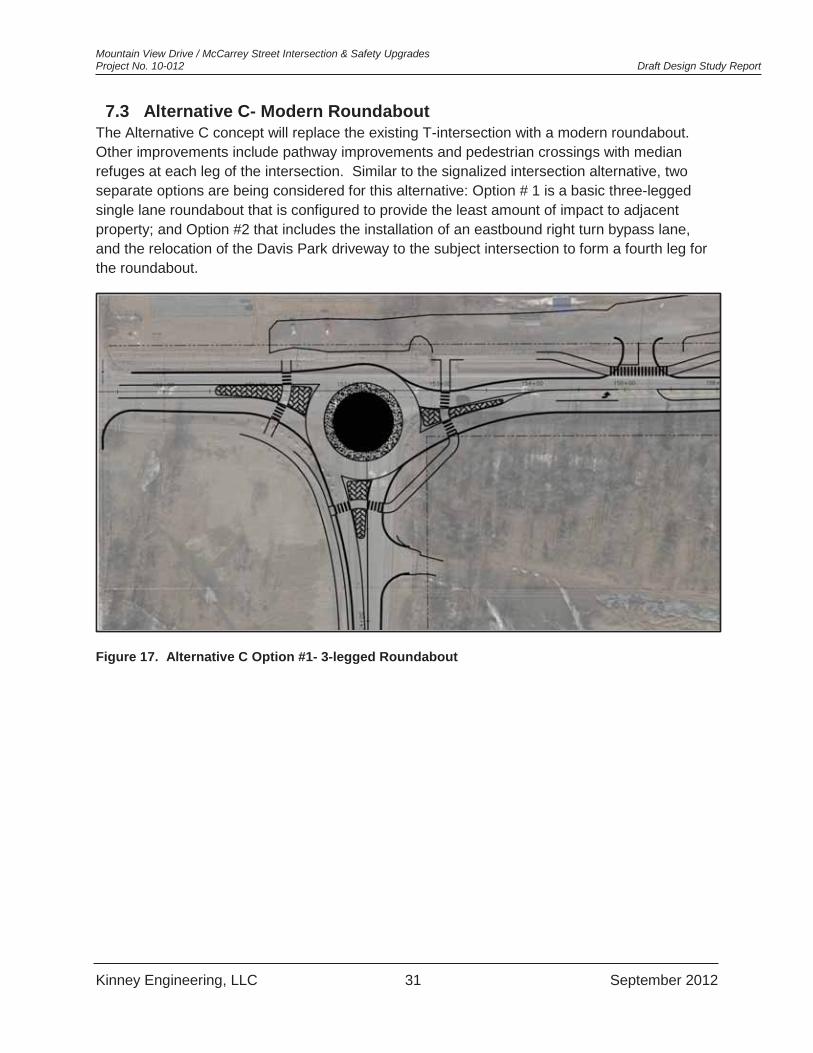
Mountain View Drive / McCarrey Street Intersection & Safety Upgrades Project No. 10-012 Draft Design Study Report
Kinney Engineering, LLC 31 September 2012
7.3 Alternative C- Modern Roundabout The Alternative C concept will replace the existing T-intersection with a modern roundabout. Other improvements include pathway improvements and pedestrian crossings with median refuges at each leg of the intersection. Similar to the signalized intersection alternative, two separate options are being considered for this alternative: Option # 1 is a basic three-legged single lane roundabout that is configured to provide the least amount of impact to adjacent property; and Option #2 that includes the installation of an eastbound right turn bypass lane, and the relocation of the Davis Park driveway to the subject intersection to form a fourth leg for the roundabout.
Figure 17. Alternative C Option #1- 3-legged Roundabout
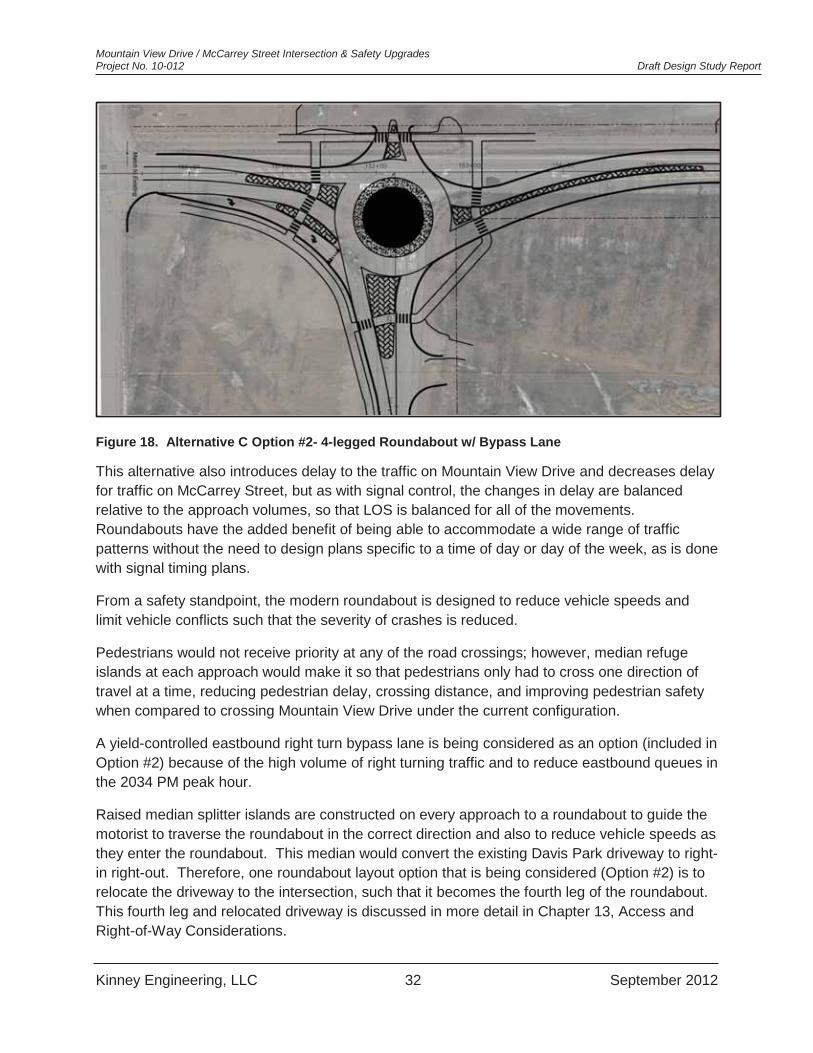
Mountain View Drive / McCarrey Street Intersection & Safety Upgrades Project No. 10-012 Draft Design Study Report
Kinney Engineering, LLC 32 September 2012
Figure 18. Alternative C Option #2- 4-legged Roundabout w/ Bypass Lane
This alternative also introduces delay to the traffic on Mountain View Drive and decreases delay for traffic on McCarrey Street, but as with signal control, the changes in delay are balanced relative to the approach volumes, so that LOS is balanced for all of the movements. Roundabouts have the added benefit of being able to accommodate a wide range of traffic patterns without the need to design plans specific to a time of day or day of the week, as is done with signal timing plans.
From a safety standpoint, the modern roundabout is designed to reduce vehicle speeds and limit vehicle conflicts such that the severity of crashes is reduced.
Pedestrians would not receive priority at any of the road crossings; however, median refuge islands at each approach would make it so that pedestrians only had to cross one direction of travel at a time, reducing pedestrian delay, crossing distance, and improving pedestrian safety when compared to crossing Mountain View Drive under the current configuration.
A yield-controlled eastbound right turn bypass lane is being considered as an option (included in Option #2) because of the high volume of right turning traffic and to reduce eastbound queues in the 2034 PM peak hour.
Raised median splitter islands are constructed on every approach to a roundabout to guide the motorist to traverse the roundabout in the correct direction and also to reduce vehicle speeds as they enter the roundabout. This median would convert the existing Davis Park driveway to right-in right-out. Therefore, one roundabout layout option that is being considered (Option #2) is to relocate the driveway to the intersection, such that it becomes the fourth leg of the roundabout. This fourth leg and relocated driveway is discussed in more detail in Chapter 13, Access and Right-of-Way Considerations.

Mountain View Drive / McCarrey Street Intersection & Safety Upgrades Project No. 10-012 Draft Design Study Report
Kinney Engineering, LLC 33 September 2012
These roundabout configurations would accommodate a WB-67 design vehicle on Mountain View Drive.
7.4 Alternative D- Raised Median Pedestrian Crossing Alternative D will provide an unsignalized raised median pedestrian crossing of Mountain View Drive on the west leg of the Mountain View / McCarrey intersection. The goal of this alternative is to provide a safer north-south crossing of Mountain View Drive for pedestrians and other non-motorized transportation users.
Figure 19. Alternative D- Raised Median Pedestrian Crossing
Installing this median will allow pedestrians to cross the road in two stages, encountering traffic from only one direction of travel at each stage. This reduces the distance over which the pedestrian is exposed to traffic and reduces the difficulty in finding a sufficient gap in the oncoming traffic that is large enough for the pedestrian to cross. In this way, a pedestrian refuge median significantly increases the safety of the pedestrian crossing at this location while at the same time reducing pedestrian delay.
Traffic operations on Mountain View Drive and on McCarrey Street will not be affected, except that speeds on Mountain View Drive may be reduced slightly in the vicinity of the median refuge island. Thus, left turning traffic from McCarrey Street will continue to have to wait for gaps in the major road traffic and may, as a result, experience poor LOS.
Mountain View Drive / McCarrey Street Intersection & Safety Upgrades Project No. 10-012 Draft Design Study Report
Kinney Engineering, LLC 34 September 2012
8. SOILS AND PAVEMENT DESIGN A paper study and site visit was conducted to determine what subsurface conditions to expect in the vicinity of the Mountain View / McCarrey intersection in conjunction with the Design Study phase of this project. A review of available as-built road drawings was conducted and pertinent test hole data analyzed and compiled. This data will be used as the basis for assumptions to determine the structural section for the newly constructed portions of road and pathway associated with the intersection improvements.
Distress in the roadway surface noted during the site visit is indicative of silty soils or poorly compacted subgrade. As such, the road structural section should be reconstructed as if it were on top of F-2 soils. Per the MOA DCM and MASS Standards, the new road segments should consist of either of the following: 83 inches Type II Classified Fill, topped with 6 inches of Type IIA Classified Fill and backfill, followed by 4 inches of leveling course and 3 inches of A.C. surfacing; or in lieu of a deep fill section, 36 inches of Type II Classified Fill, 2 inches of roadway insulation, 12 inches of Type IIA Classified Fill, and topped off with 4 inches of leveling course and 3 inches of A.C. pavement. Newly constructed segments of roadway and pathway should taper at a 10:1 rate into existing to minimize differential settlement.
9. PERMITTING REQUIREMENTS There will be a number of potential permits required to construct improvements at this intersection. The number of permits, and the type of permits required, will depend on the Alternative selected for this project.
There are no known waterways, stream channels, surface water, or wetlands within the proposed project limits. This project will not significantly alter existing drainage patterns. Possible environmental documents will be required if obtaining ROW or easements on land owned by the USAF to construct improvements.
A summary of potential permitting requirements are listed below.
9.1 Federal Permits All alternatives will require an EPA NPDES General Construction Permit.
A Categorical Exclusion or Environmental Assessment (EA) will be required to evaluate any proposed impacts to USAF owned lands. This task typically will take 6 months or more for a Categorical Exclusion and 9 months or more for an Environmental Assessment. Alternative C Options #1 and #2 will have ROW impacts on USAF land.
9.2 State of Alaska Permits Due to this project being constructed within DOT&PF ROW, a DOT&PF ROW Permit will be required for all alternatives.
This project is required to be in compliance with Alaska Department of Environmental Conservation’s (ADEC) General Wastewater Discharge permit for discharges not exceeding
Mountain View Drive / McCarrey Street Intersection & Safety Upgrades Project No. 10-012 Draft Design Study Report
Kinney Engineering, LLC 35 September 2012
500,000 gallons per day. We do not anticipate construction of any alternative to require any dewatering, or exceed this amount.
9.3 Municipality of Anchorage Permits Watershed Management Services; Storm Water Plan Review. Under AMC 21.67, the Municipality of Anchorage requires the submission of site-specific plans for projects that may discharge storm water onto land, surface water, or ground water within the Municipality. In principle, this process insures compliance with the Municipality’s NPDES permit. The process requires submission of a Storm Water Pollution Prevention Plan (SWPPP), Storm Water Treatment Plan, and a Storm Water Quality Control Plan. The information must be submitted prior to construction.
An MOA ROW permit will be required for construction of improvements within MOA ROW.
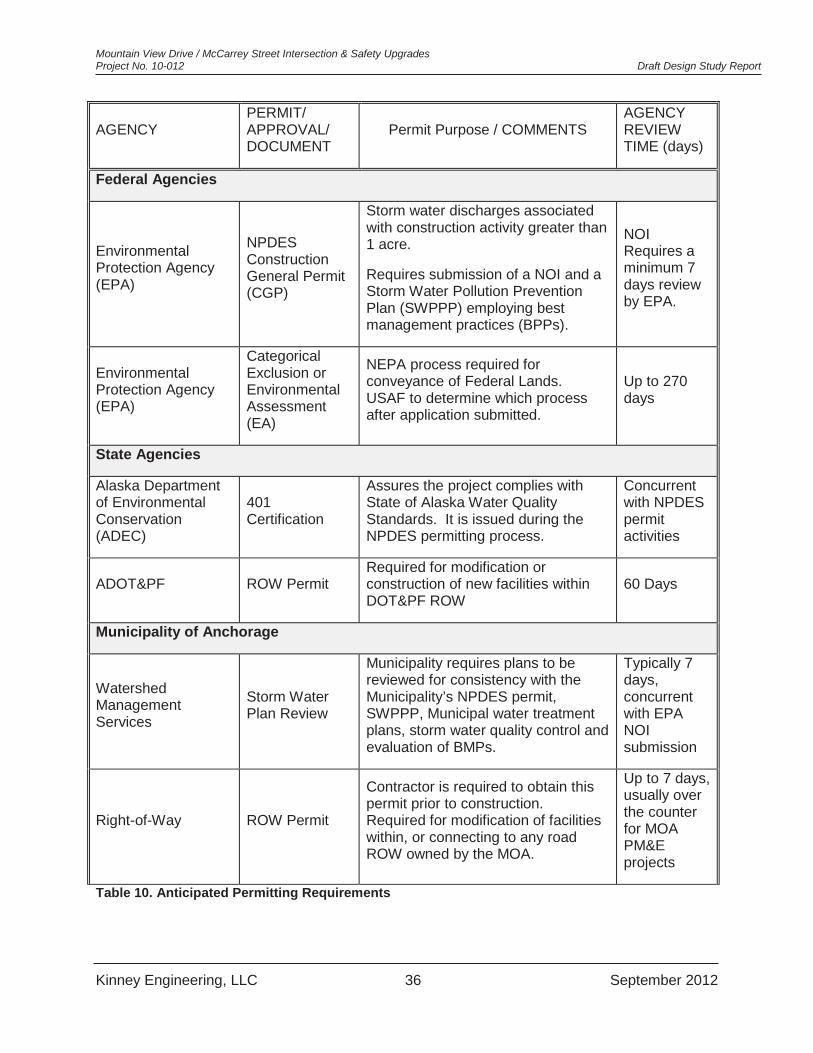
Mountain View Drive / McCarrey Street Intersection & Safety Upgrades Project No. 10-012 Draft Design Study Report
Kinney Engineering, LLC 36 September 2012
AGENCY PERMIT/ APPROVAL/ DOCUMENT
Permit Purpose / COMMENTS AGENCY REVIEW TIME (days)
Federal Agencies
Environmental Protection Agency (EPA)
NPDES Construction General Permit (CGP)
Storm water discharges associated with construction activity greater than 1 acre.
Requires submission of a NOI and a Storm Water Pollution Prevention Plan (SWPPP) employing best management practices (BPPs).
NOI Requires a minimum 7 days review by EPA.
Environmental Protection Agency (EPA)
Categorical Exclusion or Environmental Assessment (EA)
NEPA process required for conveyance of Federal Lands. USAF to determine which process after application submitted.
Up to 270 days
State Agencies
Alaska Department of Environmental Conservation (ADEC)
401 Certification
Assures the project complies with State of Alaska Water Quality Standards. It is issued during the NPDES permitting process.
Concurrent with NPDES permit activities
ADOT&PF ROW Permit Required for modification or construction of new facilities within DOT&PF ROW
60 Days
Municipality of Anchorage
Watershed Management Services
Storm Water Plan Review
Municipality requires plans to be reviewed for consistency with the Municipality’s NPDES permit, SWPPP, Municipal water treatment plans, storm water quality control and evaluation of BMPs.
Typically 7 days, concurrent with EPA NOI submission
Right-of-Way ROW Permit
Contractor is required to obtain this permit prior to construction. Required for modification of facilities within, or connecting to any road ROW owned by the MOA.
Up to 7 days, usually over the counter for MOA PM&E projects
Table 10. Anticipated Permitting Requirements

Mountain View Drive / McCarrey Street Intersection & Safety Upgrades Project No. 10-012 Draft Design Study Report
Kinney Engineering, LLC 37 September 2012
10. PEDESTRIAN AND NON-MOTORIZED TRAIL FACILITIES Pedestrian safety and mobility, as well as safety and mobility for other non-motorized modes of transportation are a priority for the Mountain View Community. The project’s goals include providing pedestrian crossings and connecting the discontinuous pathways.
10.1 Design Criteria For Commercial and Neighborhood Collectors, the MOA DCM Section 1.6 D requires a 5-10 foot pathway, separated from the roadway 0-7 feet.
The MOA DCM Section 4.2 I states that separated multi-use paths with bicycle use should be 8 to 10 feet wide. AASHTO recommends a 10-foot width for a separated two-way directional multi-use path.
10.2 Planning Documents and Future Plans Anchorage Bicycle Plan:
Mountain View Drive, Pine Street to Lane Street is a priority project on the Recommended Bicycle Network (Table 6) that would provide shared lane bicycle facilities through the use of signage and pavement markings.
McCarrey Street, from Klondike Blvd. (south of the Glenn Highway) to Mountain View Drive to accommodate bicycle traffic through the use of signage.
Anchorage Pedestrian Plan:
Link between Flower Street and McCarrey Street on south side of Mountain View Drive. (Was the Number 2 Priority Project in Pedestrian Plan, constructed in 2011*)
*This link did not connect all the way to the Mountain View Drive and McCarrey Street intersection. Instead, this pathway sweeps east then south from Pine Street to connect to McCarrey Street mid-way between Mountain View Drive and the Glenn Highway overpass.
The MOA PM&E Division lists two future proposed projects in the vicinity. The first is Mountain View Drive Area Pedestrian Safety Upgrades, and the second is Mountain View Drive Pedestrian Lighting – Taylor to Boniface. No project numbers or funding have been assigned to these two projects, but they are top priorities of the Mountain View Community Council.
10.3 Pedestrian and Non-Motorized Transportation Recommendations After review of the design criteria and proposed future plans for this project, and taking into consideration existing pathways and sidewalk connections the following improvements are recommended for inclusion in our project:
Upgrade facilities to meet current ADA standards Provide a designated crossing of McCarrey Street Provide designated crossing(s) of Mountain View Drive at McCarrey Street. (Note:
Traffic Safety commented that they do not typically provide pedestrian crossings at both
Mountain View Drive / McCarrey Street Intersection & Safety Upgrades Project No. 10-012 Draft Design Study Report
Kinney Engineering, LLC 38 September 2012
legs of a T-intersection and prefer the crossing to be on the right-hand leg for traffic operations)
Connect detached east-west pathway on the south side of Mountain View Drive and the north-south sidewalk on the west side of McCarrey Street to new curb ramp(s) and new pedestrian crossing(s).
Provide signage and/or pavement markings at striped shoulders to designate bicycle route on McCarrey Street.
The following items should not be included in the design:
Pedestrian facilities on the south side of Mountain View Drive extending east of McCarrey Street due to no connecting facilities or destinations.
10.4 Alternative A (No-Build)- Pedestrian and Non-Motorized Facilities Under the “No-Build” scenario, no separate pedestrian facilities will be constructed.
10.5 Alternative B (Signalization)- Pedestrian and Non-Motorized Facilities Alternative B would allow for the implementation of all of the pedestrian and non-motorized facility recommendations for this project, connecting existing pathway and sidewalk segments and providing protected pedestrian crossings on the east and south legs of the intersection. The east leg pedestrian crossing will connect to the sidewalk on the east side of McCarrey Street. The crossing on the south leg of the intersection will connect this facility to the east-west pathway on the south side of Mountain View Drive.
10.6 Alternative C (Modern Roundabout)- Pedestrian and Non-Motorized Facilities
Alternative C will maintain existing pedestrian pathways and provide the recommended connections and crossings at all legs of the intersection.
Pedestrian facility and crossing locations for Alternative C will provide safer crossings at medians that allow for crossing a single lane at a time.
10.7 Alternative D (Pedestrian Median Refuge)- Pedestrian and Non-Motorized Facilities
Alternative D would provide the north-south crossing of Mountain View Drive at the west leg of the intersection. The striped crosswalk, refuge in the raised median, and ramps should maintain the 8 foot width of the pathways on the north and south side of the intersection to accommodate bicycle and pedestrian traffic.

Mountain View Drive / McCarrey Street Intersection & Safety Upgrades Project No. 10-012 Draft Design Study Report
Kinney Engineering, LLC 39 September 2012
11. DRAINAGE ANALYSIS The Mountain View Drive / McCarrey Street Intersection & Safety Upgrades Project is intended to construct improvements to increase safety at the intersection. Due to the nature of the project, it is not anticipated that drainage patterns will be altered significantly, if at all. The complete drainage analysis is included in Appendix F. A summary of the given below.
11.1 Summary The project area is in upper northeast corner of the North Fork Chester Creek watershed. This area has been altered by roadway construction and development of the surrounding area. The drainage basin modeled for this project encompasses 146 acres.
Kinney Engineering has divided the drainage basin into three sub-basins for the purpose of drainage analysis. The T-intersection created by Mountain View Drive and McCarrey Street form the intersection of the three sub-basins.
The project drainage area was modeled using the NRCS SCS TR-55 program for the existing and future condition(s). Minimal changes were found between pre and post-project peak discharge due to the relatively small change in impervious area.
11.2 Results and Recommendations All alternatives should include maintaining and/or repairing existing culverts to restore their full capacity. Most culverts in the drainage basin are completely, or almost completely plugged with sediment, sand, and grass. The outlet of the culvert crossing Mountain View Drive 80 feet east of the intersection with North Pine Street appears to have been covered with fill and recent construction activities have buried the outlet end. This culvert will need to be excavated and extended, or a new culvert installed in the same or alternate location as a part of this project.
Below is a discussion of drainage considerations by alternative.
11.2.1 Alternative A (No-Build)- Drainage Considerations With the implementation of Alternative A, the “No Build” alternative, there will be no change or alteration in drainage patterns, conveyance structures, or peak discharge.
11.2.2 Alternative B (Signalization)- Drainage Considerations If a fully signalized intersection is constructed, there will be no change in current drainage patterns, and only slight increase in total impervious area. Two new catch basins will need to be installed to collect runoff from the roadway that is contained by newly installed curb and gutter. One will be located at the low point of McCarrey Street on the west side of the roadway, opposite the existing catch basin, to collect and convey runoff under the pedestrian facilities to the toe of the roadway embankment. The other new catch basin will be installed on the south side of Mountain View Drive west of McCarrey Street at the beginning of the new right turn lane. This catch basin will collect runoff and convey it to the toe of the roadway embankment very near the outlet of the existing cross drainage culvert on Mountain View Drive. A cross drainage culvert will be added to maintain existing east-west runoff patterns on the north side of Mountain View Drive where the new pedestrian crossing and link is constructed.
Mountain View Drive / McCarrey Street Intersection & Safety Upgrades Project No. 10-012 Draft Design Study Report
Kinney Engineering, LLC 40 September 2012
The existing cross drainage culvert on Mountain View Drive will need to be excavated and extended south by approximately 25 feet to clear the new pathway and roadway improvements. This cross culvert could be re-located if a better location is identified during the Design Phase of the project.
11.2.3 Alternative C (Roundabout)- Drainage Considerations If a modern roundabout is the chosen alternative, there will be minor modifications to drainage patterns in the vicinity of the roundabout.
The existing catch basin on the east side of McCarrey Street will need to be relocated to the new edge of roadway at the low point of McCarrey Street, with a matching catch basin installed on the west side at the low point.
Two new catch basins will be required on either side of Mountain View Drive west of McCarrey Street in the vicinity of the existing cross drainage culvert. Incorporating the cross drainage into the catch basins and leads would minimize cost and number of drainage structures to be maintained. The outlet from these structures should daylight very near the outlet of the existing cross drainage culvert to match existing drainage patterns.
11.2.4 Alternative D (Pedestrian Median Refuge)- Drainage Considerations Installation of a raised median pedestrian crossing will not change existing drainage patterns. A new culvert is proposed north side of Mountain View Drive to maintain existing drainage patterns under the new pedestrian link to the pathway.
11.2.5 Water Quality Right-of-way is available in the southeast quadrant of the intersection to provide a water quality treatment swale or detention facility should the preferred alternative require construction of a storm drain system.
12. UTILITY IMPACTS There are numerous overhead and underground utilities in and adjacent to the intersection of Mountain View Drive and McCarrey Street. There will be potential impacts to existing utilities that vary by alternative, although no relocations appear to be necessary. Below is a summary of potential impacts to existing utilities
12.1 Natural gas (ENSTAR) There are no known conflicts with existing ENSTAR facilities with any of the Alternatives presented in this report.
12.2 Sewer (AWWU) There are no known conflicts with existing AWWU sewer facilities with any of the alternatives presented in this report.

Mountain View Drive / McCarrey Street Intersection & Safety Upgrades Project No. 10-012 Draft Design Study Report
Kinney Engineering, LLC 41 September 2012
12.3 Water (AWWU) The 42-inch concrete cylindrical pipe water main serving Anchorage from Eklutna Lake Water Treatment Facility extends east-west beneath the Mountain View / McCarrey intersection, beneath the northern half of the 8-foot multi-use pathway. The top of this transmission main is approximately 9.5 to 10 feet below the pavement surface at this location. Any of the alternatives that propose grade changes will need to be coordinated with the elevation of the transmission main to ensure proper burial depth is maintained. Also, overburden and live loads over the pipe will be evaluated to ascertain if additional reinforcement is required.
AWWU has a valve vault in the southeast quadrant of the Mountain View Drive / North Pine Street intersection that may conflict with those proposed improvements should any extend that far east.
12.3.1 Alternative A (No-Build)- Water (AWWU) Utility Impacts Implementation of Alternative A will not impact the 42-inch water main. If Option #2 (all-way stop control) is built, sign posts will be installed which typically only extend 3 feet below the ground surface. The sign post on the north side of Mountain View Drive will be directly over the12-inch C.I. pipe. Clearance is expected to be 5-6 feet between bottom of sign foundation and top of C.I. pipe.
12.3.2 Alternative B (Signalization)- Water (AWWU) Utility Impacts Alternative B, a fully signalized intersection, presents the largest potential impact to AWWU’s 42-inch transmission main. The signal poles for the west bound and north bound legs of the intersection will require foundations that could impact the water main. Measures to mitigate the potential conflict include insulating the foundations or utilizing spread footings to prevent potential freezing issues. Shifting the intersection alignment south if required, may be an option although undesirable, as it appears that there is approximately 30 feet of ROW south of the southern edge of pavement along Mountain View Drive.
Please see AWWU’s comment in Appendix D which states “No light poles or street lights should be allowed near the transmission main.”
12.3.3 Alternative C (Roundabout)- Water (AWWU) Utility Impacts Construction of Alternative C will have very little potential to impact this transmission main. Roadway improvements will be well separated from the water main, and no grade changes or deep excavations are anticipated in its vicinity. Foundations for sign posts required for this alternative, which typically extend only 3 feet below the ground surface, will need to be approved by AWWU if in proximity to the water transmission main.
If improvements extend all the way to North Pine Street, AWWU has a valve vault in the southeast quadrant of that intersection and will require careful coordination to avoid conflict.
12.3.4 Alternative D (Pedestrian Median Refuge)- Water (AWWU) Utility Impacts Construction of Alternative D will have very little potential to impact this transmission main or adjacent 12-inch C.I. pipe, with the exception of foundations for sign posts, which typically will extend only 3 feet below the ground surface.

Mountain View Drive / McCarrey Street Intersection & Safety Upgrades Project No. 10-012 Draft Design Study Report
Kinney Engineering, LLC 42 September 2012
12.4 Electric (ML&P) There are overhead power distribution lines and power poles in the vicinity of project. There are no conflicts with implementation of Alternatives A or D. Potential conflicts with these facilities are described in more detail below for Alternatives B and C.
12.4.1 Alternative B (Signalization)- Electric (ML&P) Utility Impacts The power pole on the north side of Mountain View Drive opposite the T-intersection is in proximity to, but not in conflict with the installation signal poles necessary for Alternative B. Clearance to the overhead wires will need to be maintained during construction, and care taken during installation of the signal pole and mast arm.
12.4.2 Alternative C (Roundabout)- Electric (ML&P) Utility Impacts A potential conflict with a power pole could arise if the width of McCarrey Street is increased significantly or shifted eastward. This power pole is just south of the snow disposal site driveway along the east side of McCarrey Street, within the roadway embankment slope limits. Shifting the alignment slightly west would likely eliminate this conflict should the roadway section be widened in this segment.
12.5 Communications (telephone, cable television) ACS, GCI There are no known conflicts with existing telephone or cable television facilities with any of the alternatives presented in this report.
13. ACCESS AND RIGHT-OF-WAY CONSIDERATIONS
13.1 Access No commercial business or residential properties are located near the subject intersection within the project limits. Property zoning and ownership currently will not allow either type of development to occur within the project limits. There are two driveways within the project limit that provide access to adjacent lands. One of several entrances to Davis Park is east of the intersection, and one driveway entrance to the MOA snow storage site is located on the east side of McCarrey Street approximately 150 feet south of the intersection with Mountain View Drive.
Alternatives A and D will not impact these existing driveways. Impacts to the two driveways with implementation of Alternatives B and C are described below.

Mountain View Drive / McCarrey Street Intersection & Safety Upgrades Project No. 10-012 Draft Design Study Report
Kinney Engineering, LLC 43 September 2012
Figure 20. Driveway Impacts & Options
13.1.1 Alternative B (Signalization)- Driveway Impacts Implementation of Alternative B will affect the two existing driveways. The Davis Park driveway will be impacted by the addition of a raised median extending from the intersection east 200 feet which will cause the driveway to become right-in, right out only. Three options for addressing this driveway are: 1) leaving the driveway in place as right-in, right-out only; 2) relocating the driveway to be the 4th leg (north) of the signalized intersection; and 3) complete removal of the driveway. Analysis and discussion regarding these options are addressed in more detail later in this section.
Similarly, the driveway into the snow storage site will be impacted by the addition of a median island extending 150 feet south from the intersection blocking left turns into the snow storage site driveway. The driveway would effectively be right-in, right-out only. This will create an operational problem for MOA snow removal trucks, as they will be required to travel through the Wonder Park neighborhood north across the McCarrey Street bridge to access the snow storage site. Two options for addressing this driveway conflict are: 1) eliminate the raised median; 2) relocate the driveway south of its current location.
13.1.2 Alternative C (Roundabout)- Driveway Impacts Implementation of Alternative C will affect the two existing driveways. Alternative C Options #1 and #2 will affect the Davis Park driveway with the proposed addition of a pedestrian crosswalk in place of the driveway, and installation of a splitter island on the east leg of the roundabout, which will prevent eastbound vehicles from turning left (north) into this driveway. Complete removal of the driveway in its existing location is required for proper and safe operations of this

Mountain View Drive / McCarrey Street Intersection & Safety Upgrades Project No. 10-012 Draft Design Study Report
Kinney Engineering, LLC 44 September 2012
alternative. Alternate access is currently available at the second Davis Park driveway to the east from Mountain View Drive, and from Thompson Avenue to the north on the east side of North Pine Street. Analysis and discussion regarding removal of this driveway is addressed in more detail later in this section.
Alternative C Option #2 seeks to incorporate the westernmost Davis Park driveway as the 4th leg to the roundabout, by relocating the driveway approximately 75 feet to the west of its current location. Please see the discussion regarding this driveway below.
Alternative C Option #2 will impact the driveway accessing the snow storage site where the splitter island for the south leg of the roundabout will block southbound left turns into the snow storage site. If blocked, this driveway would effectively be right-in, right-out only. This will create an operational problem for MOA snow removal trucks, as they will be required to travel through the Wonder Park neighborhood north across the McCarrey Street bridge to access the snow storage site. Two options for addressing this driveway conflict are to truncate the splitter island, or to relocate the driveway to the south. Please see the discussion of options for this driveway in section 13.3 below.
Alternative C Option #1, a 3-leg roundabout will not block access and therefore continue to allow left turns at the snow storage site driveway.
13.2 Davis Park Driveway Discussion and Analysis With the implementation of Alternatives B and C, three possible variations to address the driveway have been analyzed. These variation are: 1) close off the driveway; 2) reconfigure the driveway to right-turn in, right-turn out only; and 3) to relocate the driveway to align with the 4th leg of a signalized intersection or roundabout.
13.2.1 Close off Davis Park Driveway The MOA DCM Section 1.9H states that the number of access points for a property off public ROW should be kept to a minimum. Additionally, comments from the MOA Traffic Division indicated that they wish the existing driveway to be closed off or moved. Furthermore, MOA DCM Appendix 1-D Municipality of Anchorage Driveway Standards indicate that the nearest edge of a driveway to the nearest edge of the intersection of two public streets should be 150 feet for a medium volume generator roadway with a speed limit of 30 mph. Westbound, where the speed limit is 45 mph, the driveway setback from an intersecting roadway should be 310 feet.
Alternate access to Mountain View Lion’s Community Park is available on the on the north side of the park off Thompson Avenue, where a paved developed parking area is available for park users. Access to the unimproved gravel parking area north of the intersection is also available from the main Davis Park driveway off of Mountain View Drive 400 feet to the east of the subject driveway where the gravel parking area extends west from the paved parking area for Davis Park. A third parking area for park users to access the park is provided along the east side of North Pine Street, where on-street parking is allowed.
Mountain View Drive / McCarrey Street Intersection & Safety Upgrades Project No. 10-012 Draft Design Study Report
Kinney Engineering, LLC 45 September 2012
Closing off the subject driveway will increase pedestrian safety by eliminating one pedestrian/vehicle conflict point.
Traffic circulation and safety will be improved by closing off the driveway, eliminating a point where vehicles are currently entering the roadway very near the existing intersection, or decelerating to execute a turn where there is no dedicated turn lane into the driveway.
13.2.2 Reconfigure Davis Park driveway as “right- in, right-out” Reconfiguring the driveway as right-in right-out is a compromise solution allowing west bound traffic to make right turns into the farthest west driveway into Davis Park, and vehicles exiting the park to make right turns onto Mountain View Drive. Unrestricted access will be maintained at the driveway located 400 feet east of the subject driveway.
As discussed in the previous section, driveways should be set back from the intersection of public roads a minimum of 150 feet for a posted speed limit of 30 mph and 310 feet for a posted speed limit of 45 mph.
13.2.3 Relocate Davis Park driveway to 4th leg of intersection The final treatment for the driveway is to relocate the driveway 75 feet west of its current location so it forms the 4th leg of the intersection. The effects of relocating this driveway were analyzed, with the traffic and pedestrian operations analysis discussed and presented in Chapter 19.
Adding the 4th leg to the intersection has little impact on vehicle operations over a T-intersection, whether it be a signalized intersection or a roundabout. Pedestrian LOS increases from LOS C to B with the addition of the 4th leg of the signalized intersection, as it may allow the west leg pedestrian crossing to be constructed.
However, existing utilities and ROW present design difficulties for inclusion of the fourth leg of the intersection. A power pole and guy anchors encroach into to the parking area and limit access and continuity between sections of the parking area and the main driveway to the park. Vehicles currently drive very close to the power pole and beneath one of the guy anchors, or drive along the multi-use pathway around the power pole to gain access to the segment of the parking area that would be accessed by the proposed fourth leg.
The existing ROW ends approximately 9 feet north of the multiuse pathway along the north side of Mountain View Drive. Space available to construct curb returns, splitter islands, and other roadway features within the existing ROW is limited. A potential solution is to provide a curb cut only for the fourth leg of the signalized intersection to limit impact to the existing parking area. Similarly for the roundabout alternatives, the splitter island could be truncated, or the entire roundabout shifted slightly south to minimize impact to the parking area with incorporation of the fourth leg.
To accommodate access via the fourth leg of the intersection, 6 or more parking spaces would be removed, and the parking area re-configured to allow room for vehicles to turn and maneuver when exiting and entering the fourth leg of the intersection.

Mountain View Drive / McCarrey Street Intersection & Safety Upgrades Project No. 10-012 Draft Design Study Report
Kinney Engineering, LLC 46 September 2012
The 4th leg of the intersection would be utilized by a relatively low number of vehicles. The traffic forecast for the design year with an assumption of 2% growth, indicates 21 vehicles per hour would utilize the intersection’s 4th leg during the PM peak hour.
13.2.4 Davis Park Driveway Recommendation Based on the facts and discussion presented above, it is our recommendation to close off the existing driveway entirely for both Alternative B and C. Relocating the driveway to the fourth leg of the intersection is possible for both Alternatives B and C, but will require a reconfiguration of the parking area at a net loss of parking spaces and will require relocation of a power pole and guy anchors to provide continuity to the remainder of Davis Park parking areas and main driveway.
13.3 Driveway Entrance to MOA Snow Disposal / Storage Site The driveway into the Municipality of Anchorage’s snow disposal site on the east side of McCarrey Street will be impacted by Alternatives B and C.
Impact to this driveway resulting from Alternative B includes the extension of the left turn lane by approximately 25 feet to meet the minimum required length of 150 feet. A raised island protecting the left turn pocket will be installed, preventing vehicles from making left turns into the driveway, and preventing vehicles exiting the driveway from making left turns as well. The driveway would function as right-in, right-out, which is not desirable from the standpoint that trucks hauling snow would need to drive through the Wonder Park subdivision neighborhood to utilize this driveway.
Impact from Alternative C Option #2 affecting this driveway is the construction of the roundabout’s south splitter island. This island will block left turns in and out of this driveway resulting in right-in right-out only access. Trucks would need to access the snow disposal site by driving north through the Wonder Park neighborhood as described above.
One solution to the driveway impact resulting from Alternatives B and C Option #2 would be a realignment of the existing driveway approximately 75 feet south of its current location. This would allow for right and left turns entering and exiting the driveway without crossing the left turn pocket and south of any raised median barriers or splitter islands required for traffic safety operations. However, a Temporary Construction Easement and/or Permit will be required by the USAF to relocate the driveway.
13.4 Right-of-Way The segments of Mountain View Drive and McCarrey Street within our project area are in DOT&PF ROW. The area in the southwest quadrant of the intersection is a large parcel of DOT&PF ROW that is bounded by the outer edges by Mountain View Drive on the north, McCarrey Street on the east, North Pine Street on the west, and the Glenn Highway on the south.
13.4.1 Mountain View Drive The MOA 2005 OS&HP requires a minimum ROW width of 80 feet for Class IA Industrial/Commercial Collector Streets. In the project area, Mountain View Drive is within

Mountain View Drive / McCarrey Street Intersection & Safety Upgrades Project No. 10-012 Draft Design Study Report
Kinney Engineering, LLC 47 September 2012
DOT&PF ROW. The ROW width is 100 feet east of the intersection with McCarrey Street. Between McCarrey Street and Pine Street, the ROW width extends south approximately 900 feet onto undeveloped DOT&PF ROW. West of Pine Street, the ROW width is 60 feet.
13.4.2 McCarrey Street The MOA 2005 OS&HP requires a minimum ROW width of 60 feet for Class 1C Neighborhood Collector Streets. North of the Glenn Highway, McCarrey Street is within a 394 feet wide block of DOT&PF ROW that includes Pine Street on the western edge. The centerline of McCarrey Street is approximately 65 feet from the eastern ROW boundary.
Final evaluation of potential ROW impacts will be conducted after survey has been completed during the design phase.
13.4.3 Alternative A (No-Build)- Right-of-Way Impacts Alternative A will require no additional ROW or easement acquisition.
13.4.4 Alternative B (Signalization)- Right-of-Way Impacts A fully signalized intersection can be constructed within existing DOT&PF ROW. Slope easements may be required along the east side of the McCarrey Street ROW, and along the south side of Mountain View Drive ROW east of the intersection on USAF land, to accommodate roadway widening in these areas. This widening is necessary to address the lengthening of the left turn lanes to meet current DCM requirements, and the resulting increase in roadway cross section.
13.4.5 Alternative C (Roundabout)- Right-of-Way Impacts Construction of a roundabout at this intersection will require additional ROW in the southeast quadrant of the intersection. A 10,000 square-foot triangular-shaped piece of land will need to be obtained from the northeast corner of the MOA snow disposal site. This ROW would be on property owned by the USAF and will take a significant amount of time and require environmental documents prior to the transaction. Please see discussion under Section 9.1 Federal Permits.
13.4.6 Alternative D (Pedestrian Median Refuge)- Right-of-Way Impacts Alternative D will require no additional ROW or easement acquisition.
13.5 Parking On street parking is permitted on Neighborhood and Industrial/Commercial Collector Streets, where allowed, with a minimum shoulder width of 7 feet, per DCM Table 1-4. Current street width and striping provides less than 7 foot shoulders throughout most of the project limits.
Parking is available for Davis Park outside of the ROW to the north of Mountain View Drive, and therefore should not be incorporated into the design for any of the alternatives.
Mountain View Drive / McCarrey Street Intersection & Safety Upgrades Project No. 10-012 Draft Design Study Report
Kinney Engineering, LLC 48 September 2012
14. MAINTENANCE CONSIDERATIONS Mountain View Drive and McCarrey Street are currently maintained by the Municipality of Anchorage. Snow removal from pathways and sidewalks in the project area is accomplished by two different departments. MOA Street Maintenance clears the snow from the pathways along McCarrey Street, and the MOA Parks Department removes snow from the multi-use pathway along the north side of Mountain View Drive. Probable impacts to existing maintenance operations are described by alternative below.
14.1 Alternative A (No-Build)- Maintenance Alternative A is the “No Build” Alternative. As such, there are no additional facilities to create maintenance obligations above current levels.
14.2 Alternative B (Signalization)- Maintenance The construction of a signalized intersection will increase overall maintenance obligations.
14.2.1 Storm Drain Maintenance (Alternative B) Two new culverts and two catch basins with leads will be required to maintain drainage patterns in the project area, and will require periodic maintenance.
14.2.2 Signals and Street Light Maintenance (Alternative B) Installation of the new signal poles and illumination will require more long-term maintenance by the MOA Signal Maintenance and Street Light Maintenance over existing conditions.
14.2.3 Landscape Maintenance (Alternative B) Additional landscaping maintenance will be required, as landscaping enhancements are planned for the project.
14.2.4 Snow Removal (Alternative B) Snow removal operations for the roadways will be similar to existing procedures once snow removal equipment operators become familiar with the new medians at the intersection. Curb to curb width at medians should exceed 16 feet for safe plowing operations. The addition of two new curb ramps and two crosswalks will require additional man and equipment hours during the winter months.
14.3 Alternative C (Roundabout)- Maintenance A roundabout will require more maintenance effort than for existing conditions, but less long-term maintenance effort than a signalized intersection.
14.3.1 Storm Drain Maintenance (Alternative C) Any new storm drain pipes, inlets, and other structures necessary in conjunction with construction of the roundabout will require periodic maintenance.

Mountain View Drive / McCarrey Street Intersection & Safety Upgrades Project No. 10-012 Draft Design Study Report
Kinney Engineering, LLC 49 September 2012
14.3.2 Signals and Street Light Maintenance (Alternative C) A roundabout will require additional street lights to provide the lighting levels recommended in the MOA DCM and NCHRP Report 672.
14.3.3 Landscape Maintenance (Alternative C) Additional landscape maintenance effort will be required, as landscape enhancements are planned for this project.
14.3.4 Snow Removal (Alternative C) A roundabout will require more maneuvers with the snow removal equipment, and/or multiple passes as well as removal of snow from the truck apron, central, and splitter islands to clear all areas of snow and maintain sight distances during the winter months.
14.4 Alternative D (Pedestrian Median Refuge)- Maintenance Maintenance operations will require few changes to existing levels of maintenance.
14.4.1 Storm Drain Maintenance (Alternative D) One cross-drainage culvert will be added, which will require periodic maintenance to remove road sand, sediment, and vegetation that may impair culvert function.
14.4.2 Snow Removal (Alternative D) Snow removal operations will need to be modified slightly in the vicinity of the raised pedestrian refuge median during the winter months, but should not affect the overall operations at the intersection.
15. STREET ILLUMINATION (DOT&PF) The existing street lighting system is owned and maintained by the DOT&PF. The existing street lighting originates at a load center south of the Glenn Highway on the east side of the McCarrey Street bridge. Upgrades or modifications to the existing lighting system are not planned if Alternative A or D is selected for this project.
15.1 Alternative B (Signalization)- Street Illumination Constructing a fully signalized intersection will require modification of the existing street illumination facilities at the Mountain View / McCarrey intersection. New lighting will be provided in combination with the signal poles, meeting the minimum requirements of DCM Chapter 5, and as necessary to match existing lighting type (high-pressure sodium) adjacent to the project area. The first street light on the south side of Mountain View Drive, and east of the intersection will need to be relocated south approximately 5 feet from its current location to accommodate the widened roadway in this segment.
A detailed analysis for illumination will be conducted during the Design.

Mountain View Drive / McCarrey Street Intersection & Safety Upgrades Project No. 10-012 Draft Design Study Report
Kinney Engineering, LLC 50 September 2012
15.2 Alternative C (Roundabout)- Street Illumination Providing a roundabout in place of the existing intersection will require a redesign and reconstruction of the street lighting system in the immediate project area. New street lights at each leg of the roundabout meeting the requirements of DCM Chapter 5 and the IES Design Guide for Roundabout Lighting, are planned with the implementation of this alternative. The standard for lighting levels at roundabouts requires double the illumination levels of a collector street with medium pedestrian activity (1.8 fc vs. 0.9 fc.).
16. LANDSCAPING Landscaping enhancements are being planned for this project’s “build” alternatives. The enhancements shall meet the requirements of the MOA DCM Chapter 3 Landscaping, and as approved by DOT&PF for installation within their ROW.
Comments generated from the Concept Report phase of this project indicate that a community gateway feature should be considered. Chapter 3 of the MOA DCM supports this consideration.
Additionally, comments from the Public Transportation Department indicate their desire to see improved transit stops east of North Pine Street (the existing stops are west of North Pine Street). The existing transit stops are unimproved, consisting of a bus stop sign and schedule only, with no developed waiting area outside of the sidewalks and are without ADA access.
17. CONSTRUCTION PHASING AND TRAFFIC CONTROL Alternative A will not require construction phasing, and traffic control will only be needed when installing stop bar striping if Option #2 (all-way stop) is selected.
Construction should be phased to minimize impact to local traffic, and transient or cut through traffic discouraged through the use of “Local Traffic Only” signage.
If needed, traffic can bypass the intersection construction by utilizing Bragaw Street to the west, Boniface Drive to the east, and the Glenn Highway to the south, allowing for temporary full lane closures without impacting access to business or residential areas.
Pedestrians can be routed around construction activity on the west side of McCarrey Street on the pathway constructed in 2011, except when improvements impact this segment of pathway. East-west access on the multi-use pathway on the north side of Mountain View Drive can remain unimpeded for the majority of the construction, except during removal or relocation of the Davis Park driveway, or making pathway connections. Signage can be placed on trails so that bicycle commuters can use alternate routes to connecting trails during periods where access cannot be maintained for through-traffic.
Mountain View Drive / McCarrey Street Intersection & Safety Upgrades Project No. 10-012 Draft Design Study Report
Kinney Engineering, LLC 51 September 2012
18. PUBLIC INVOLVEMENT SUMMARY Public Involvement for this project is being conducted in accordance with the MOA’s 2008 A Strategy for Developing Context Sensitive Transportation Projects.
Public Involvement activities began for this project in February 2012, with the creation of a website dedicated to the project (www.mountainviewandmccarrey.com). The following summarizes public involvement activities to date.
Post Card & E-Newsletter Invite to Open House March, 2012 Mountain View Business Roundtable Presentation February 29, 2012 Mountain View Community Council Presentation March 12, 2012 Open House at Mountain View Library April 5, 2012 Agency Presentation April 12, 2012 Individual Stakeholder Contact As Necessary
A Draft Concept Report was distributed for review in June, 2012. The complete Concept Report including public involvement materials, meeting minutes, and sign-in sheets can be found in Appendix D.
19. TRAFFIC OPERATION AND SAFETY Comparisons between the alternatives were made by looking at the delay and LOS for the PM peak hour in the design year. All alternatives were analyzed using both the 1% and 2% growth scenarios discussed in Section 5.2 Growth Rate; however, only the 1% growth scenario is presented in this section for the reasons discussed in Section 5.2. The comparable information for the 2% growth scenario can be found in Appendix F. Table 11 depicts the vehicular LOS, delay, and computed 95th percentile queue length for each alternative. Table 12 depicts the pedestrian LOS and delay for each alternative. Table 2 describes the effect of the different alternatives on the expected crash rate.

Mountain View Drive / McCarrey Street Intersection & Safety Upgrades Project No. 10-012 Draft Design Study Report
Kinney Engineering, LLC 52 September 2012
PM Peak 2034 1% Growth
EB WB NB SB
Alt A, Option 1 and Alt D,
Two-way stop
LOS A A E
Average Delay (s) None None 49
95th % queue (ft.) None None Not calculated
Alt A, Option 2 All-way Stop
LOS F C B
Average Delay (s) 138.4 17.1 11.1
95th % queue (ft.) Not calculated Not calculated
Not calculated
Alt B,
3 leg signal no EB RT lane
LOS C B B
Average Delay (s) 31.5 14.5 14.5
95th % queue (ft.) 514 155 61
Alt B,
3 leg signal w/ EB RT lane
LOS B B B
Average Delay (s) 13.5 10.8 12.7
95th % queue (ft.) 266 146 57
Alt B,
4 leg signal w/ EB RT lane
LOS B B B B
Average Delay (s) 14.2 10.9 13.6 12.1
95th % queue (ft.) 280 147 61 15.0
Alt C, Opt 1
Roundabout (3 leg)
LOS C A B
Average Delay (s) 22.7 9.8 11
95th % queue (ft.) 253 70 30
Alt C, Opt 1
Roundabout (3 leg) with EB RT bypass
LOS B A B
Average Delay (s) 12.2 9.9 10.9
95th % queue (ft.) 133 73 30
Alt C, Opt. 2
Roundabout (4 leg)
LOS C A B A
Average Delay (s) 21.5 9.6 10.5 6.2
95th % queue (ft.) 245 70 30 2.5
Table 11. Comparison of Vehicle Delay, Queue Length, and Level of Service for Alternatives

Mountain View Drive / McCarrey Street Intersection & Safety Upgrades Project No. 10-012 Draft Design Study Report
Kinney Engineering, LLC 53 September 2012
PM Peak
2034 1% Growth
West Approach East Approach South Approach
Alt A, Option 1 Two-way stop
LOS F F A
Delay (s) 292 181 None
Alt A, Option 2 All-way stop
LOS A A A
Delay (s) None None None
Alt B, Signal, 3-legged
LOS C1 B B
Delay (s) 36 19 17
Alt B, Signal, 4-legged
LOS B B B
Delay (s) 19 19 17
Alt C, Roundabout
LOS C B A
Delay (s) 11 9 3
Alt D, Pedestrian Refuge
LOS C F A
Delay (s) 11 181 None
1 Under a 3-legged signalized intersection, pedestrian crossing of west approach would not be permitted, forcing these pedestrians to cross both the east approach and the south approach, lowering the level of service for this movement.
Table 12. Comparison of Pedestrian Delay and Level of Service for Alternatives

Mountain View Drive / McCarrey Street Intersection & Safety Upgrades Project No. 10-012 Draft Design Study Report
Kinney Engineering, LLC 54 September 2012
Alternative Intersection Crashes
2001 to 2010 (if traffic control had been
installed)
Crashes / Million Entering Vehicles
Alt A, Option 1 Two-way Stop
28 0.615
Alt A, Option 2 All-way Stop
20 0.439
Alt B, Signal 22 0.483 Alt C, Roundabout 20 0.439 Alt D, Pedestrian Refuge 28 0.615 Table 13. Comparison of Intersection Crash Rate – 2001 through 2010 for Alternatives
19.1 Alternative A (No-Build) Traffic Operation and Safety
19.1.1 Alternative A Vehicular Traffic
The stop control, or “do nothing,” scenario would result in excessive delay in 2034 for northbound traffic on McCarrey Street. Under the option for all-way stop control, excessive delay would be experienced by the eastbound Mountain View Drive traffic. Since there are more vehicles traveling eastbound than northbound, this indicates that overall delay would be greater under all-way stop control than under existing conditions.
19.1.2 Alternative A Pedestrian Traffic
As noted in Section 3.3 Pedestrian and Non-Motorized Facilities, pedestrian crossings at Mountain View Drive near McCarrey Street currently experience LOS F as defined by the HCM. As vehicular volumes increase in the future, this will exacerbate this condition, making it nearly impossible for pedestrians to cross the road safely in the PM peak hour. Under LOS F, pedestrians are likely to choose to cross in gaps that are too short, causing conflicts between vehicular and pedestrian traffic. The pedestrian crossing of McCarrey Street will experience no delay, however, because pedestrians have priority on stop-controlled approaches.
If all-way stop control is installed, pedestrian delay would be minimized, because pedestrians would have priority over all of the vehicular movements on all legs of the intersection.
19.1.3 Alternative A Crash Evaluation
Safety improvements were evaluated using crash modification factors taken from the DOT&PF Alaska Highway Safety Improvement Program Handbook, the AASHTO Highway Safety Manual, or the Crash Modification Factor Clearinghouse. Specific types of crashes are reduced under all-way stop control as compared to two-way stop control. If all-way stop control had been installed, there would have been 8 fewer right angle crashes (-70%) for the 10 year period

Mountain View Drive / McCarrey Street Intersection & Safety Upgrades Project No. 10-012 Draft Design Study Report
Kinney Engineering, LLC 55 September 2012
from 2001 through the end of 2010. This would have resulted in a total of only 20 crashes over the 10 year period, as compared to the 28 crashes that did occur.
19.2 Alternative B (Signalization) Traffic Operation and Crash Evaluation
In order to evaluate traffic operations and safety under signal control, it is necessary to determine the correct parameters of the signal operation. Left turn phasing was evaluated using the MOA methodology found in the Design Criteria Manual (DCM). Using this methodology, it was found that permissive left turns were acceptable for all left turn movements. Clearance intervals and pedestrian walk timings were also calculated in accordance with the DCM. The signal was assumed to operate actuated-uncoordinated, with a nominal cycle length of 65 seconds (optimized using Synchro).
19.2.1 Alternative B Vehicular Traffic
If a signal were installed, the resulting intersection LOS would be LOS B, with no individual movements experiencing a LOS worse than C. This is the case for both a 3-legged intersection (existing geometry) or for a four-legged intersection (where the driveway to the park is relocated as the fourth leg). However, under signalization the eastbound leg would have very long queues that would extend past the intersection with Pine Street in the design year. As a result, the signalized intersection was also analyzed with an eastbound right-turn lane. The resulting intersection LOS remains B and the queue lengths are reduced, but the queues will sometimes still extend into the Pine Street intersection 240 feet away.
19.2.2 Alternative B Pedestrian Traffic
Under signal control, the pedestrian LOS will remain LOS C or better through the design year at the crosswalks. However, under 3-legged signal control a pedestrian crossing would not be provided on the west approach to the intersection, in accordance with direction from the MOA. Since the majority of pedestrians who cross Mountain View Drive at McCarrey Street currently cross the west approach, this configuration may present a safety hazard if pedestrians continue to cross the west approach in violation of the signing and signals after the signal is installed.
19.2.1 Alternative B Crash Reduction
In terms of safety, specific types of crashes may be reduced under signal control as compared to two-way stop control. If a traffic signal had been installed, there would have been 8 fewer right angle crashes (-60%), but there may have been as many as 2 more rear end crashes (+25%) for the 10 year period from 2001 through the end of 2010. This would have resulted in a net decrease of 6 crashes over the 10 year period: a total of 22 crashes as compared to the 28 crashes that did occur during this period.

Mountain View Drive / McCarrey Street Intersection & Safety Upgrades Project No. 10-012 Draft Design Study Report
Kinney Engineering, LLC 56 September 2012
19.3 Alternative C (Roundabout) Traffic Operation and Crash Evaluation
19.3.1 Alternative C Vehicular Traffic
Similar to the analysis of signal control, both a three-leg (Option #1) and a four-leg (Option #2) roundabout (where the driveway to the park is added as the fourth leg) were analyzed. Both would operate well, with LOS B overall. The expected eastbound queues would sometimes extend into the Pine Street intersection; however, if an eastbound right turn bypass lane is constructed as shown in Option #2, the 95th percentile queues are shortened to the extent that they do spill back to the Pine Street intersection.
19.3.2 Alternative C Pedestrian Traffic
The roundabout options would reduce pedestrian delay for two reasons. First, pedestrians will only need to look for gaps in one direction of traffic at a time because of the median refuge islands on all of the approaches. Second, some drivers will yield to pedestrians crossing at the marked crosswalks, further decreasing pedestrian delay. Even if no drivers yield to pedestrians in the roundabout crosswalks, the expected pedestrian LOS to cross the full approach in each direction is expected to be LOS C or better in the 2034 PM peak hour.
19.3.1 Alternative C Crash Reduction
In terms of safety, roundabouts are seen as reducing overall crashes as compared to two-way stop control. If a roundabout had been installed, there would have been 8 fewer crashes (-30%) for the 10 year period from 2001 through the end of 2010. This would have resulted in a total of only 20 crashes over the 10 year period, as compared to the 28 crashes that did occur during this period.
19.4 Alternative D (Pedestrian Median Refuge) Traffic Operation and Crash Reduction
19.4.1 Alternative D Vehicular Traffic
Under Alternative D, vehicular traffic operations would remain materially the same as under Alternative A, with no delay for vehicles traveling on Mountain View Drive and poor LOS for the left turns from McCarrey Street.
19.4.2 Alternative D Pedestrian Traffic
Under Alternative D, pedestrians desiring to cross the west approach of Mountain View Drive will be able to do so in two stages, crossing only one direction of traffic at a time with a safe refuge to wait in before finishing their crossing. The total delay crossing this approach will be reduced significantly compared to Alternative A, with pedestrian LOS at LOS C or better in the 2034 PM peak hour. The delay at other approaches will be unchanged.

Mountain View Drive / McCarrey Street Intersection & Safety Upgrades Project No. 10-012 Draft Design Study Report
Kinney Engineering, LLC 57 September 2012
19.4.1 Alternative D Crash Reduction
The pedestrian refuge island is likely to act as a traffic calming device, encouraging drivers to travel at slower speeds and providing a visual clue to inform westbound drivers that they are entering a more built-up area. In this way, the pedestrian island may improve safety.
There is not sufficient data to determine the magnitude of the safety effect of the installation of a pedestrian refuge island and crosswalk markings. Results from safety studies of similar installations show some improvement in pedestrian safety and also find that pedestrian volumes increase at locations where pedestrian refuge islands are installed and that vehicles are more likely to yield to pedestrians at such locations.
20. COST ESTIMATES All cost estimates were developed utilizing the MOA PM&E Division’s 2011 Average Bid Tab value for the unit cost of each bid item. No inflation adjustment has been made at this time.
20.1 Alternative A, Option #2 Cost Estimate- All-Way Stop The estimated costs for construction, construction administration, design, temporary easements, permits, and utility relocations for Alternative A, Option #2 are outlined in the following table, a detailed estimate is provided in Appendix E.
Construction Costs Totals
CONSTRUCTION+25% Contingency $ 14,600
CONSTRUCTION ADMINISTRATION $ 2,200
DESIGN & PERMITTING $ 5,100
TEMPORARY EASEMENTS/PERMITS $ -
UTILITY RELOCATIONS $ -
TOTAL ESTIMATE ALTERNATIVE A $ 22,000
Table 14. Alternative A Option #2 Estimated Costs

Mountain View Drive / McCarrey Street Intersection & Safety Upgrades Project No. 10-012 Draft Design Study Report
Kinney Engineering, LLC 58 September 2012
20.2 Alternative B Cost Estimate- Signalized Intersection The estimated costs for construction, construction administration, design, temporary easements, permits, and utility relocations for Alternative B, are outlined in the following table, a detailed estimate is provided in Appendix E. The cost estimate has been developed with the assumption that a new right-turn lane will be constructed as an integral component of this alternative.
Construction Costs Totals
CONSTRUCTION+25% Contingency $ 1,918,800
CONSTRUCTION ADMINISTRATION $ 287,800
DESIGN & PERMITTING $ 287,800
TEMPORARY EASEMENTS/PERMITS $ 30,000
UTILITY RELOCATIONS $ -
TOTAL ESTIMATE ALTERNATIVE B $ 2,524,400
Table 15. Alternative B Estimated Costs
20.3 Alternative C Cost Estimate, Roundabout The estimated costs for construction, construction administration, design, temporary easements, permits, and utility relocations for Alternative C Options #1 and 2, are outlined in the following table, a detailed estimate is provided in Appendix E.
Construction Costs Totals Option #1 Totals Option #2
CONSTRUCTION+25% Contingency $ 1,626,400 $ 1,690,500
CONSTRUCTION ADMINISTRATION $ 304,900 $ 317,000
DESIGN & PERMITTING $ 304,900 $ 317,000
TEMPORARY EASEMENTS/PERMITS $ 30,000 $ 30,000
UTILITY RELOCATIONS $ -0- $ -0-
TOTAL ESTIMATE ALTERNATIVE C $ 2,672,900 $ 2,777,100
Table 16. Alternative C- Options #1 & 2 Estimated Costs

Mountain View Drive / McCarrey Street Intersection & Safety Upgrades Project No. 10-012 Draft Design Study Report
Kinney Engineering, LLC 59 September 2012
20.4 Alternative D Cost Estimate, Raised Median Pedestrian Refuge The estimated costs for construction, construction administration, design, temporary easements, permits, and utility relocations for Alternative D, are outlined in the following table, a detailed estimate is provided in Appendix E.
Construction Costs Totals
CONSTRUCTION+25% Contingency $ 123,500
CONSTRUCTION ADMINISTRATION $ 18,500
DESIGN & PERMITTING $ 43,200
TEMPORARY EASEMENTS/PERMITS $ -
UTILITY RELOCATIONS $ -
TOTAL ESTIMATE ALTERNATIVE D $ 186,700
Table 17. Alternative D Estimated Costs
21. SCHEDULE AND TIMELINE This project will continue with the design phase and ROW activities through 2013. Bid advertising and bid date is scheduled for April and May 2014, with construction planned for summer 2014.
22. ALTERNATIVE EVALUATION AND RECOMMENDATION
22.1 Alternatives Evaluation The purpose of this project is to improve traffic circulation and safety at the Mountain View Drive/McCarrey Street intersection, and improve pedestrian and bicycle safety. The criteria for recommending an alternative are that the alternative must meet the purpose and need and provide long-term value for any added benefits beyond the purpose and need.
22.1.1 Evaluation Criteria
Each of the design alternatives are evaluated on the criteria listed below:

Mountain View Drive / McCarrey Street Intersection & Safety Upgrades Project No. 10-012 Draft Design Study Report
Kinney Engineering, LLC 60 September 2012
Traffic Operations – Degree to which alternative attains good level of service (LOS C or better) through the design year.
Traffic Safety/Crash Reduction – Expected reduction in vehicular conflicts and crashes as a result of the alternative.
Pedestrian Operations – Degree to which alternative attains good level of service (LOS C or better) through the design year for pedestrians.
Pedestrian Safety – Expected reduction in pedestrian conflicts and crashes as a result of the alternative.
Total Cost – Estimated cost of the alternative.
Other Considerations – Any extenuating circumstances that would cause an alternative to be unfeasible.
22.1.2 Alternatives Comparison
For traffic operations, the roundabout alternatives are the clear standout. Even without a bypass lane, Alternative C Option #1 outperforms a signalized intersection with a right turn lane in the construction, mid-life, and design year.
For Traffic Safety, Alternative C Options #1 and #2 are expected to reduce overall number of crashes and crash severity. An all-way stop is expected to reduce the number of crashes to the same extent. A signalized intersection could reduce right-angle crashes, but can cause an increase in rear end crashes, so does not perform as well as the other alternatives.
Alternative A Option #2, an all-way stop, provides the highest pedestrian LOS, followed by the roundabout alternatives, and then a signalized intersection. However, the roundabout alternatives provide links and connections to all existing pathways, whereas an all-way stop does not.
Pedestrian safety is ranked the highest with a signalized intersection, with a four-legged intersection providing protected crossings in all directions. A three-legged intersection would only allow protected movements in two directions. An all-way stop would provide protected crossings for pedestrians in all directions similar to a signalized intersection, but without the full protection offered by a signal. The roundabout options would provide safer pedestrian crossings in all directions over existing conditions.
An all-way stop is the least cost of the alternatives considered, followed by a raised median pedestrian refuge. A signalized intersection will be slightly less expensive to construct than the roundabout alternatives, but will incur higher long-term maintenance costs.

61
Table 18. Evaluation Criteria Comparison by Alternative Alternative & Description
Traffic Operations (during PM Peak hour) in Design Year (2034)
Crash Reduction Pedestrian Operations (during PM Peak hour)
Pedestrian Safety Construction Cost
Other Considerations
Alternative A (No Build) Option #1- Two-way stop
Northbound movement (approx. 100 vehicles per hour) experiences significant delay (49 s)
No improvement Pedestrians cannot safely cross Mountain View Drive(west leg 282 s delay, East Leg 181 s delay)
No Change Lowest
Option #2- All way stop Eastbound movement (approx. 900 vehicles per hour) experiences unacceptably high delay (138 s)
Reduces right angle crashes Pedestrians have priority on all legs (0 s delay)
Provides protected crossings Lowest
Alternative B (Signal Control) Three-legged intersection, no eastbound right turn lane
All movements operate at LOS C or better. Eastbound traffic experiences excessive queuing (514’), beyond nearest intersection (Pine Street)
Reduces right angle crashes, increases rear end crashes
Pedestrian delay is minimal (17-19 s); however, no pedestrian crossing is allowed across west approach
Provides protected crossings on south and east leg, no protected crossing on west leg
Highest
Three-legged intersection, Eastbound right turn lane
All movements operate at LOS C or better. Eastbound queues ( 266 ft.) sometimes reach nearest intersection (Pine Street)
May reduce rear-end crashes over options without the eastbound right turn lane
For 3-legged intersection: no change (17-19 s delay), no crossing at west approach leg.
Provides protected crossings on south and east leg, no protected crossing on west leg
Highest
Option #3- Four-legged intersection
All movements operate at LOS C or better. No change in eastbound queues (266 ft.) over 3-legged intersection above
Reduces right angle crashes, increases rear-end crashes
Pedestrian delay is minimal (17-19 s); allows pedestrian crossing on west approach, however crossing distance is longer w/ right turn lane.
Provides protected crossings on all legs of intersection
Highest Impacts to Davis Park are significant.
Alternative C (Roundabout) Option #1- Three-legged roundabout, no eastbound bypass lane
All movements operate at LOS C or better. Queues are shorter (253 ft.) than with a signal
Reduces overall number of crashes and crash severity
Pedestrian delay is minimal (3-11 s) Increased safety due to crossing only one direction/lane of traffic at a time
Second Highest
ROW acquisition required
Option #1- 3 leg w/eastbound right turn bypass lane
All movements operate at LOS C or better. Eastbound queues (133 ft.) rarely or never reach nearest intersection (Pine Street)
May reduce rear-end crashes over options without the eastbound right turn bypass lane
Pedestrian delay is minimal (3-11 s), but Increases the number of pedestrian crossings for west approach from 2 to 3
Increases the number of pedestrian crossings for west approach
Second highest
ROW acquisition required
Option #2- Four-legged roundabout w/bypass
All movements operate at LOS C or better. No change in eastbound queues over 3-leg roundabout w/ bypass (133 ft.).
Reduces overall number of crashes and crash severity
Pedestrian delay is minimal (3-11 s) Increased safety due to crossing only one direction/lane of traffic at a time
Second highest
Impacts to Davis Park are significant.
Alternative D (Pedestrian Refuge) Raised Median Pedestrian Crossing
Northbound movement (approx. 100 vehicles per hour) experiences significant delay (49 s)
No improvement in Traffic Safety over existing conditions
Pedestrian delay crossing west approach is minimal (11 s); there is still significant pedestrian delay for crossing the east approach
Increased safety on the west approach due to crossing only one direction/lane of traffic at a time
Second lowest
Table 18. Evaluation and Comparison of Alternatives

Mountain View Drive / McCarrey Street Intersection & Safety Upgrades Project No. 10-012 Draft Design Study Report
Kinney Engineering, LLC 62 March 2012
22.2 Recommended Alternative
Base on the evaluation criteria, Alternative C Option #1 or Option #2 provide the best overall traffic operations in the construction, mid-life, and design year; and increases pedestrian safety at all legs of the intersections. In addition, the roundabout alternatives provide trail and pathway connectivity and have lower long-term maintenance cost when compared with Alternative B. Alternative C Option #1 can be expanded to include a yield control right-turn-bypass lane,

Kinney Engineering, LLC 750 West Dimond Blvd..
Ste. 203 Anchorage, AK 99515 www.kinneyeng.com