monitoring the effects of environmental flows on … · web view‘monitoring the effects of...
TRANSCRIPT

Dece
mbe
r 20
13 [U
pdat
e
Insert report title here
Draft Report
Prepared by: Darren S. Baldwin and Kerry L. Whitworth
Monitoring the effects of environmental flows on hypoxic
blackwater in the Murray and Murrumbidgee Rivers

Monitoring the effects of environmental flows on hypoxic blackwater in the Murray and Murrumbidgee Rivers
This monitoring project was commissioned by the Commonwealth Environmental Water Office.
Copyright
© Copyright Commonwealth of Australia, 2014
‘Monitoring the effects of environmental flows on hypoxic blackwater in the Murray and Murrumbidgee Rivers’ is licensed by the Commonwealth of Australia for use under a Creative Commons By Attribution 3.0 Australia licence with the exception of the Coat of Arms of the Commonwealth of Australia, the logo of the agency responsible for publishing the report, content supplied by third parties, and any images depicting people. For licence conditions see: http://creativecommons.org/licenses/by/3.0/au/
This report should be attributed as ‘Monitoring the effects of environmental flows on hypoxic blackwater in the Murray and Murrumbidgee Rivers, Commonwealth of Australia 2014’.The Commonwealth of Australia has made all reasonable efforts to identify content supplied by third parties using the following format ‘© Copyright, [name of third party] ’.
Disclaimer
The views and opinions expressed in this publication are those of the authors and do not necessarily reflect those of the Australian Government or the Minister for the Environment. While reasonable efforts have been made to ensure that the contents of this publication are factually correct, the Commonwealth does not accept responsibility for the accuracy or completeness of the contents, and shall not be liable for any loss or damage that may be occasioned directly or indirectly through the use of, or reliance on, the contents of this publication.
ii

This report was prepared by The Murray-Darling Freshwater Research Centre (MDFRC). The aim of the MDFRC is to provide the scientific knowledge necessary for the management and sustained utilisation of the Murray-Darling Basin water resources. The MDFRC is a joint venture between the Murray-Darling Basin Authority, La Trobe University and CSIRO (through its Division of Land and Water). Additional investment is provided through the Australian Government Department of the Environment.
For further information contact:
Dr Darren BaldwinThe Murray-Darling Freshwater Research CentrePO Box 991Wodonga Vic. 3689Ph: (02) 6024 9650; Fax: (02) 6059 7531
Email: [email protected]: www.mdfrc.org.auEnquiries: [email protected]
Report Citation: ‘Monitoring the effects of environmental flows on hypoxic blackwater in the Murray and Murrumbidgee Rivers, Commonwealth of Australia 2014’ Baldwin, D.S. and Whitworth, K.L. (2013) Report prepared for Commonwealth Environmental Water Office by The Murray-Darling Freshwater Research Centre, MDFRC.
Cover Image: Confluence of the Murray and Murrumbidgee Rivers
Photographer: Mr David Wood (MDFRC)
Filename and path: Projects/CEWOO/Blackwater monitoring/Final Report/Murrumbidgee Blackwater Draft Report
Author(s): Darren S. Baldwin and Kerry L. WhitworthProject Manager: Darren S. BaldwinClient: Commonwealth Environmental WaterProject Title: Monitoring the effects of environmental flows on hypoxic blackwater in the
Murray and Murrumbidgee RiversDocument Version: Draft
Acknowledgements: The authors acknowledge the assistance of the NSW Office of Water, the
Mallee Catchment Management Authority, Thiess Services, the Murray-Darling Basin Authority,
Adrian Clements, David Wood, Braeden Lampard, Greg Cranston, Brendan Curtin and John Pengelly.
iii

Contents
Executive Summary...................................................................................................................1
1 Introduction........................................................................................................................2
2 Commonwealth Environmental Watering..........................................................................3
3 Site and event description..................................................................................................3
4 Methods..............................................................................................................................7
4.1 Existing water quality data..........................................................................................7
4.2 Additional monitoring.................................................................................................7
4.2.1 DOC analysis.....................................................................................................10
5 Results and Discussion.....................................................................................................10
5.1 Water quality in the Murrumbidgee River................................................................10
5.1.1 Dissolved oxygen...............................................................................................10
5.1.2 Dissolved organic carbon...................................................................................12
5.2 Water quality in the Murray River............................................................................13
5.2.1 Dissolved oxygen...............................................................................................13
5.2.2 Dissolved organic carbon...................................................................................16
5.3 Mixing at the junction of the Murray and Murrumbidgee Rivers.............................17
5.4 Use of mixing models to predict DO and DOC........................................................19
5.5 Impact of environmental water delivery on downstream DO...................................22
6 Guiding principles for using environmental flows to mitigate hypoxia caused by
blackwater................................................................................................................................24
7 Conclusions......................................................................................................................27
8 Acknowledgements..........................................................................................................27
9 References........................................................................................................................28
iv

Executive Summary
Hypoxic blackwater is characterised by a high concentration of dissolved organic carbon and
low concentration of dissolved oxygen in the water column. Hypoxia can be stressful or fatal
to many aquatic organisms.
Hypoxic blackwater was generated on the Murrumbidgee River floodplains during summer
and autumn flooding (from rainfall) in 2012. Very low dissolved oxygen was recorded in the
river channel downstream of Balranald for upwards of a month. Inflows of this water into the
Murray River also posed a risk to water quality in the Murray downstream of the confluence,
especially when Murray discharge began to recede while Murrumbidgee discharge remained
high in April 2012.
In order to provide and maintain oxygenated refuge habitats for aquatic animals along the
main stem of the Murray River, the Commonwealth Environmental Water Office delivered
an environmental flow through the Murray River system of up to 120,000 megalitres. This
was in addition to pre-existing environmental flows in the system. Examination of mixing
patterns at and downstream of the junction revealed that Murray River water mixed
completely with the hypoxic Murrumbidgee water within 5 river kilometres. Dissolved
oxygen profiles also showed that a corridor of oxygenated water persisted past the junction,
which would have created oxic refuges and facilitated the passage of biota upstream to
oxygenated water.
The impact of the additional environmental water delivery on downstream water quality
could be predicted with reasonable accuracy using simple mixing models. Under a worst
case scenario the base flow in the Murray River during the hypoxic blackwater event was
predicted to fall as low as 1800 megalitres per day. Modelling showed that the additional
environmental water delivered in this study would have substantially improved water quality
downstream of the confluence of the Murray and Murrumbidgee Rivers if base flows had
fallen to 1800 megalitres per day.
1

1 Introduction
Blackwater is characterised by a high concentration of dissolved organic carbon (DOC) in the
water column. Transfer of organic carbon from floodplains to the river channel is vital for the
sustenance of riverine food webs. However, microbial respiration of this carbon consumes
oxygen and if oxygen consumption exceeds re-aeration, dissolved oxygen (DO)
concentrations fall. This is known as hypoxic blackwater (Howitt et al. 2007). Hypoxic
blackwater is often responsible for fish kills and other adverse effects on aquatic biota.
Oxygen concentrations below 4 mg/L are generally considered to impose stress on aquatic
biota and many biota cannot survive if DO falls below 2 mg/L (Gehrke 1988).
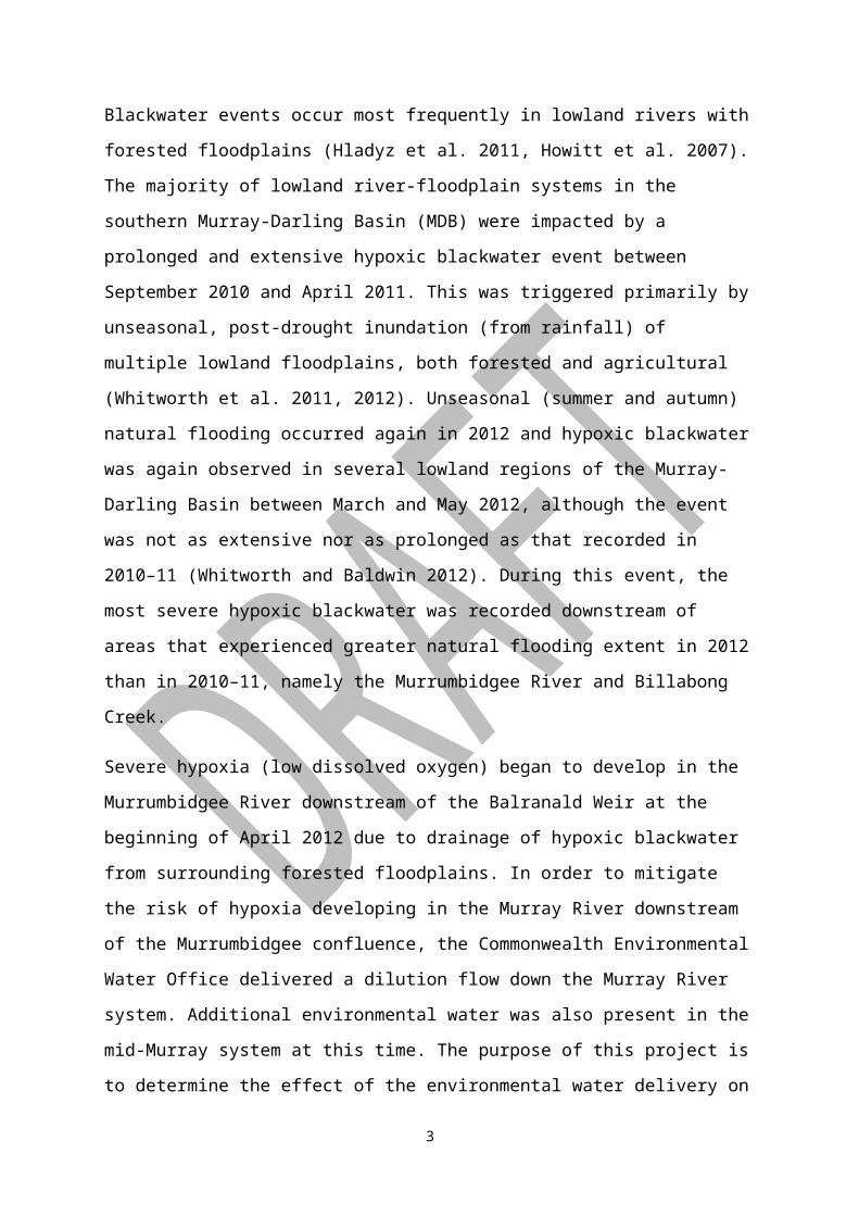
Blackwater events occur most frequently in lowland rivers with forested floodplains (Hladyz
et al. 2011, Howitt et al. 2007). The majority of lowland river-floodplain systems in the
southern Murray-Darling Basin (MDB) were impacted by a prolonged and extensive hypoxic
blackwater event between September 2010 and April 2011. This was triggered primarily by
unseasonal, post-drought inundation (from rainfall) of multiple lowland floodplains, both
forested and agricultural (Whitworth et al. 2011, 2012). Unseasonal (summer and autumn)
natural flooding occurred again in 2012 and hypoxic blackwater was again observed in
several lowland regions of the Murray-Darling Basin between March and May 2012,
although the event was not as extensive nor as prolonged as that recorded in 2010–11
(Whitworth and Baldwin 2012). During this event, the most severe hypoxic blackwater was
recorded downstream of areas that experienced greater natural flooding extent in 2012 than in
2010–11, namely the Murrumbidgee River and Billabong Creek.
Severe hypoxia (low dissolved oxygen) began to develop in the Murrumbidgee River
downstream of the Balranald Weir at the beginning of April 2012 due to drainage of hypoxic
blackwater from surrounding forested floodplains. In order to mitigate the risk of hypoxia
developing in the Murray River downstream of the Murrumbidgee confluence, the
Commonwealth Environmental Water Office delivered a dilution flow down the Murray
River system. Additional environmental water was also present in the mid-Murray system at
this time. The purpose of this project is to determine the effect of the environmental water
delivery on water quality in the Murray River downstream of the Murrumbidgee confluence.
2

2 Commonwealth Environmental Watering
In response to the blackwater event in the Murrumbidgee River the Commonwealth
Environmental Water Holder allocated up to 120,000 megalitres (ML) of environmental
water to help mitigate the potential impact of hypoxic blackwater from the Murrumbidgee
River on aquatic biota in the Murray River. The specific purpose of this water was to
“provide and maintain oxygenated refuge habitats for aquatic animals along the main stem of
the Murray River”. One of the principal concerns guiding the decision was that:
“[i]f environmental water is not provided from Hume Dam, operation
rules require that releases from Hume are minimised so that flows below
Yarrawonga are reduced from the current rate of around 7000 ML/day to
around 4000 ML/day in the following weeks and could be reduced to a
rate as low as 1800 ML/day if demands remain low and there is no rainfall
(Damien Green, MDBA, pers. comm. 12 April 2012)”
from Appendix 1,Water Use Minute no. 87
Given that peak flows from the Murrumbidgee River were predicted to be of the order of
35000 ML/day, and DO in the Murrumbidgee River downstream of Balranald were 0 mg/L
there was a substantial risk that, in the absence of environmental flows, and flows in the
Murray River falling as low as 1800 ML/day, Do levels in the Murray River downstream of
the confluence with the Murrumbidgee would also fall close to 0mg/L and this plume would
persist for many 10-100’s of km in the main river channel. As was shown in the 2010/2011
event, such a plume of hypoxic blackwater can result in substantial fish deaths (King et al.,
2012)
3 Site and event description
The Murrumbidgee River originates in the Snowy Mountains of the Great Dividing Range
and flows through upland forest, hilly pastoral land and finally flat land dominated by
irrigated agriculture (Figure 1). Several small floodplain forests are present downstream of
Narrandera and a large area of river red gum forested floodplain (mostly within the
boundaries of Yanga National Park) is located just upstream of Balranald. Additional areas of
forested floodplain exist between Balranald and the Murrumbidgee River confluence. The
3

floodplain area within and downstream of Yanga National Park is commonly known as the
Lowbidgee floodplain.
Figure 1: Murrumbidgee River catchment (note that the Lachlan River does not connect with the Murrumbidgee but terminates in a large wetland complex).
The Lowbidgee floodplain lies within a semi-arid climatic zone (Hutchinson et al. 2005) with
an annual average rainfall of 320 mm per year (Australian Government Bureau of
Meteorology 2012). This floodplain is dependent on overbank flows, primarily derived from
winter and spring rainfall and snow melt in the upper catchment, for maintenance of
ecological character (Bren 1992; Kingsford 2000). The region suffered both local drought
and a drastic reduction in flows originating from upstream for much of 2000–2010 decade
(Figure 2). This situation came to an abrupt end in late 2010, with unprecedented spring and
summer rainfall causing the drought to be broken not only in the Murrumbidgee River
catchment but across the entire southern Murray-Darling Basin by a series of widespread
flood events.
4

Year
1980 1990 2000 2010
Dis
char
ge (M
L/da
y)
0
5000
10000
15000
20000
25000
30000
35000
Dis
char
ge (M
L/da
y)
0
10000
20000
30000
40000
50000
60000
70000a)
b)
Figure 2: Murrumbidgee River hydrographs for a) Hay and b) Balranald from 1980–present, showing period of very low discharge 2000–2010 and flooding in 2010–11 and 2012.
High summer and autumn rainfall occurred again in 2012 and, in the Murrumbidgee River
catchment, the 2012 flood magnitude exceeded that recorded in 2010–11. Hydrographs from
the Murrumbidgee at Hay, Maude Weir, Redbank Weir and Balranald during the 2012 flood
5
event (
Date (2012)
Jan Feb Mar Apr May Jun
Dis
char
ge (M
L/da
y)
0
10000
20000
30000
40000
50000
60000
70000
D/S Hay WeirD/S Maude WeirD/S Redbank WeirD/S Balranald Weir
) indicate that downstream of Hay, much of the flow travelled overland, leading to extensive
floodplain inundation. Leaching and subsequent decomposition of carbon from organic
material on these floodplains would have caused hypoxic conditions to develop (Whitworth
et al. 2012). Much of the flow returned to channel upstream of Balranald, leading to the in-
channel hypoxia described in the introduction.
6

Date (2012)
Jan Feb Mar Apr May Jun
Dis
char
ge (M
L/da
y)
0
10000
20000
30000
40000
50000
60000
70000
D/S Hay WeirD/S Maude WeirD/S Redbank WeirD/S Balranald Weir
Date (2012)
Jan Feb Mar Apr May Jun
Dis
char
ge (M
L/da
y)
0
10000
20000
30000
40000
50000
60000
70000
D/S Hay WeirD/S Maude WeirD/S Redbank WeirD/S Balranald Weir
Figure 3: Murrumbidgee River hydrographs for Hay, Maude Weir, Redbank Weir and Balranald during the 2012 flood event.
7
4 Methods
Data collection for this project consisted of two components:
1. Collation of existing water quality data from agency monitoring programs
2. Collection of additional water quality data.
4.1 Existing water quality data
The New South Wales Office of Water (NOW) maintains a dissolved oxygen and
temperature logger in the Murrumbidgee River downstream of Balranald Weir. The Mallee
Catchment Management Authority (MCMA), the Victorian Department of Sustainability and
Environment (via Thiess Services) and NOW also undertake routine and event-based water
quality monitoring in the southern Murray-Darling Basin. Data from these sources were made
available to the current project (see Figure 4 for locations of relevant monitoring sites). River
discharge data were obtained from the Murray-Darling Basin Authority and NOW.
4.2 Additional monitoring
Six optical DO and temperature probes with data loggers (D-Opto, Zebra-tech, New Zealand)
were deployed in the Murray River for the collection of additional DO and temperature data
during the current project. These were placed: upstream of the Wakool River junction;
upstream and downstream of the Murrumbidgee River junction; at Euston (upstream of the
weir); at Mildura (downstream of the weir); and at Fort Courage (downstream of the Darling
River and Darling River Anabranch junctions) (Table 1). The loggers were deployed from 27
April until 30 May 2012 and were cleaned on a weekly basis.
Table 1: Locations of temporary loggers deployed for DO monitoring
Location description Latitude Longitude Notes
Upstream of Wakool junction (Kenley)
-34.86043° 143.34990° ~150 m upstream of junction
Upstream of Murrumbidgee junction
-34.73129° 143.22149° ~300 m upstream of junction
Downstream of Murrumbidgee junction
-34.71339° 143.18774° ~5 river km downstream (3.5 km direct line) of junction
8

Euston (upstream of weir) -34.58942° 142.75157° ~1 km downstream of Euston Club boat ramp
Mildura (downstream of weir) -34.16869° 142.16067° Logger located on yellow salinity structure opposite Mildura homestead
Fort Courage (downstream of Darling Anabranch)
-34.09806° 141.72465° ~1km downstream of Fort Courage boat ramp
The New South Wales Office of Water was also commissioned to undertake additional water
quality monitoring on a weekly basis (particularly measurement of DO and temperature and
collection of samples for DOC analysis) between 27 April and 30 May 2012 at six sites on
the Murrumbidgee River (Hay Weir, Maude Weir, Redbank Weir, Balranald Weir, Waldaria
and Weimby) and three sites on the Murray River (Heywood’s Inlet, Boundary Bend and
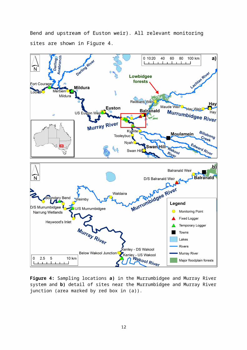
upstream of Euston weir). All relevant monitoring sites are shown in Figure 4.
9
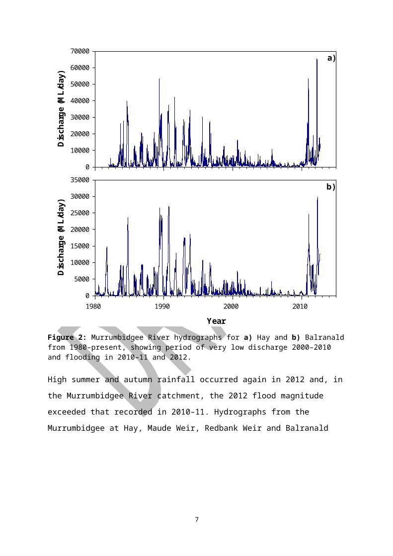
Figure 4: Sampling locations a) in the Murrumbidgee and Murray River system and b) detail of sites near the Murrumbidgee and Murray River junction (area marked by red box in (a)).
10

Additionally, an intense sampling program was undertaken on 8 May 2012 to explore the
nature of the mixing processes at the confluence of the Murray and Murrumbidgee Rivers. A
boat was used to traverse six transects in:
the Murray River about 500 m upstream of the Murrumbidgee River junction
the Murrumbidgee River about 750 m upstream of the junction
the Murray River 170 m and 0.5, 1.0 and 5.0 km downstream of the confluence.
At approximately six points along each transect, DO and temperature were measured at 0.2,
1, 2, 3, 4 and 5 m depths using a Hydrolab Quanta water quality multi-meter (Hach
Environmental).
4.2.1 DOC analysis
Samples for DOC analysis were filtered (0.45 µm cellulose acetate membrane) into 30 mL
poly-carbonate vials, transported on ice to the laboratory and frozen until analysis. Blanks
were collected on each sampling day by treating a sample of ultra-pure water (Milli-Q;
Millipore) in the same manner as the samples. Dissolved organic carbon was determined by
the NATA-accredited chemical analytical laboratory at the Murray-Darling Freshwater
Research Centre, using the persulfate oxidation method (APHA 2005).
5 Results and Discussion
5.1 Water quality in the Murrumbidgee River
5.1.1 Dissolved oxygen
Dissolved oxygen in the Murrumbidgee River upstream of the Lowbidgee floodplain (as
recorded at Hay, Maude Weir and Redbank Weir) dropped to <4 mg/L with the passage of
the flood pulse in the second half of March (Figure 5). Water quality at these sites prior to the
flooding is unknown, as no DO data is available from these sites for the period from late
January to mid-March 2012. However, the available data from further downstream at
Balranald suggests that water quality was probably reasonable during this period (Figure 5).
As discharge receded in these middle reaches of the river, DO increased again, returning to
>5 mg/L by the end of March and ~8 mg/L by mid-April at Hay and Maude Weir. At
Redbank Weir the recovery was a little slower; DO remained below 5 mg/L until mid-April
then steadily increased to >8 mg/L by early May.
11

Further downstream at Balranald, DO began to fall sharply with the first step increase in
discharge in early March. By early April, DO was <1 mg/L and this situation persisted until
the end of the month. After the main flow peak passed (and a concurrent decrease in
temperature occurred; data not shown) DO began to steadily increase, returning to ~6 mg/L
by mid-May and >7 mg/L by the end of May.
Date (2012)
Jan Feb Mar Apr May Jun
Dis
solv
ed o
xyge
n (m
g/L)
0
2
4
6
8
10
12
14
Dis
char
ge (M
L/da
y)
0
10000
20000
30000
40000
50000
60000
70000Hay DO - spotMaude Weir DO - spotRedbank Weir DO - spotBalranald DO - avg Balranald DO - spotD/S Hay Weir DischargeD/S Balranald Weir Discharge
Figure 5: Dissolved oxygen (spot measurements and daily averages from loggers) in the Murrumbidgee River between Hay and Balranald. Also shown is river discharge at Hay and Balranald. Data: NOW.
12

Distance upstream of Murray confluence (km)
0 1 2 3 4 5 30 35 40 45
Dis
solv
ed o
xyge
n (m
g/L)
0
1
2
3
4
5
18/04/12 27/04/1203/05/12 08/05/12 D/S Balranald
Weir
Figure 6: Dissolved oxygen (spot measurements) in the Murrumbidgee River at sites between D/S Balranald Weir and the Murray River confluence on four sampling occasions during March and April 2012. Data: NOW.
Of all monitoring sites on the lower Murrumbidgee River, the site downstream of Balranald
Weir yielded the most complete DO dataset for the study period, due to the presence of a
fixed logger in addition to regular site visits for spot sampling. Figure 6 demonstrates that
there is little (<0.5 mg/L) difference between the DO recorded at this monitoring site and
sites further downstream towards the Murray confluence. Therefore, the more complete
dataset from the downstream Balranald Weir site can be used to represent the water quality at
the Murray River confluence.
5.1.2 Dissolved organic carbon
Dissolved organic carbon sampling commenced in late April 2012. At this time, the main
flood peak had already passed through sites upstream of the Lowbidgee floodplains. The peak
in DOC concentrations at these sites may have occurred prior to the commencement of
monitoring. At Hay and Maude Weirs, DOC was near 5 mg/L throughout the monitoring
period (Figure 7a). At Redbank Weir, DOC was approximately 10 mg/L in late April and
declined to approximately 5 mg/L by early May.
13

The flood pulse was near its peak at Balranald at the time that DOC sampling commenced. At
this time, DOC was in the 16–24 mg/L range at sites between Balranald and the Murray
confluence (Figure 7b). A slow downward trend was evident over the monitoring period. By
the start of June, DOC at Balranald was below 10 mg/L.
DO
C (m
g/L)
0
5
10
15
20
25
Hay WeirMaude Weir Redbank Weir
Date (2012)
23-Apr 30-Apr 07-May 14-May 21-May 28-May 04-Jun
DO
C (m
g/L)
0
5
10
15
20
25
BalranaldWeimby Waldaira
a)
b)
Figure 7: Dissolved organic carbon in the Murrumbidgee River at sites a) upstream and b) downstream of Balranald between late April and early June 2012. Error bars are one standard error (n = 3). Data: NOW; MDFRC.
5.2 Water quality in the Murray River
5.2.1 Dissolved oxygen
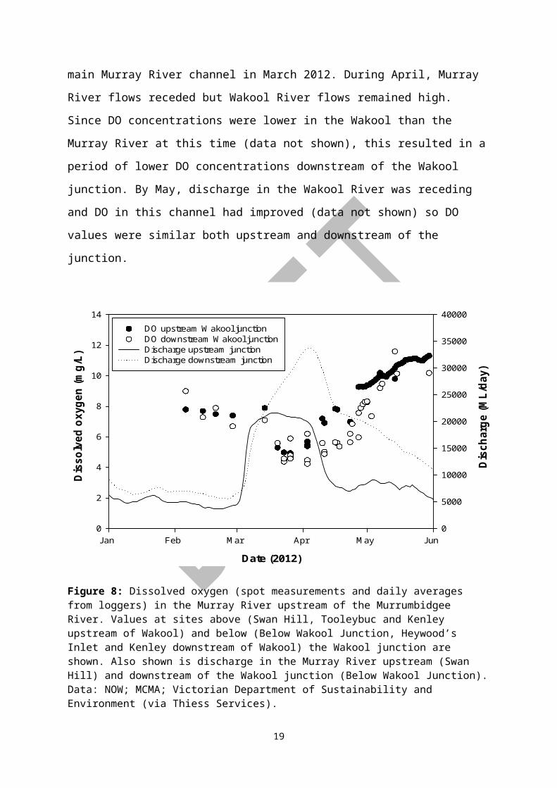
Dissolved oxygen in the Murray River upstream of the Murrumbidgee junction generally
remained above 4 mg/L throughout the 2012 floods (Figure 8; see also Whitworth and
Baldwin 2012). A drop in DO from about 8 mg/L to about 4.5 mg/L was observed both
upstream and downstream of the Wakool junction with the passage of the flood pulse in the
14
main Murray River channel in March 2012. During April, Murray River flows receded but
Wakool River flows remained high. Since DO concentrations were lower in the Wakool than
the Murray River at this time (data not shown), this resulted in a period of lower DO
concentrations downstream of the Wakool junction. By May, discharge in the Wakool River
was receding and DO in this channel had improved (data not shown) so DO values were
similar both upstream and downstream of the junction.
Date (2012)
Jan Feb Mar Apr May Jun
Dis
solv
ed o
xyge
n (m
g/L)
0
2
4
6
8
10
12
14
Dis
char
ge (M
L/da
y)
0
5000
10000
15000
20000
25000
30000
35000
40000
DO upstream Wakool junctionDO downstream Wakool junctionDischarge upstream junctionDischarge downstream junction
Figure 8: Dissolved oxygen (spot measurements and daily averages from loggers) in the Murray River upstream of the Murrumbidgee River. Values at sites above (Swan Hill, Tooleybuc and Kenley upstream of Wakool) and below (Below Wakool Junction, Heywood’s Inlet and Kenley downstream of Wakool) the Wakool junction are shown. Also shown is discharge in the Murray River upstream (Swan Hill) and downstream of the Wakool junction (Below Wakool Junction). Data: NOW; MCMA; Victorian Department of Sustainability and Environment (via Thiess Services).
Inflows of water from the Murrumbidgee River into the Murray River represented only a
minor portion of total downstream flow prior to April 2012 (Figure 9). Little data is available
for DO downstream of the Murrumbidgee junction for the first three months of 2012, but
three data points from late March and early April suggest that DO values in the Murray River
were similar both upstream and downstream of the Murrumbidgee junction until mid-April
2012 (Figure 9). In mid-April Murray River discharge began to decline sharply while
Murrumbidgee discharge remained high. At this time, a DO difference of approximately
15

2 mg/L became evident either side of the junction. With Murray flows forecast to continue
decreasing while Murrumbidgee flows were predicted to remain high, it was feared that the
impact of the hypoxic water emanating from the Murrumbidgee system on water quality in
the Murray River would become more severe in late April and early May. To reduce this risk,
environmental water was used to slow the flow recession in the Murray River. Although a
DO disparity of 2–4 mg/L either side of the junction remained evident until late May, DO did
not drop below 3.5 mg/L in the Murray River downstream of the junction.
Date (2012)
Jan Feb Mar Apr May Jun
Dis
solv
ed o
xyge
n (m
g/L)
0
2
4
6
8
10
12
14
Dis
char
ge (M
L/da
y)
0
10000
20000
30000
40000
50000DO upstream MurrumbidgeeDO downstream MurrumbidgeeDischarge upstream MurrumbidgeeDischarge downstream Murrumbidgee
Figure 9: Dissolved oxygen (spot measurements and daily averages from loggers) in the Murray River upstream (Below Wakool Junction, Heywood’s Inlet and Kenley downstream of Wakool) and downstream (D/S Murrumbidgee, Boundary Bend and Narrung Wetlands) of the Murrumbidgee confluence. Also shown is discharge in the Murray River upstream (Below Wakool Junction) and downstream (Boundary Bend) of the Murrumbidgee junction. Data: NOW; MCMA; Victorian Department of Sustainability and Environment (via Thiess Services).
Further downriver, DO in the Murray River downstream of the Mildura Weir was generally
above 7 mg/L throughout the first half of 2012, with the exception of a brief drop to about
6 mg/L with the passage of the March/April flood pulse (Figure 10). Dissolved oxygen in the
lower Darling River at Tapio (data courtesy of NOW) was near 6 mg/L from January to April
2012, then gradually increased towards 8 mg/L during May. Inflows of Darling River water
caused a slight decrease in DO in the Murray River channel. During the monitoring period,
16

the daily average DO recorded by the logger at Fort Courage was 0.87 ± 0.04 mg/L (n = 36)
lower than the value recorded at Mildura. However, since Darling River DO levels were not
sufficiently low to be of concern to aquatic biota, no intervention was required at this site.
Date (2012)
Jan Feb Mar Apr May Jun
Dis
solv
ed o
xyge
n (m
g/L)
0
2
4
6
8
10
12
Dis
char
ge (M
L/da
y)
0
10000
20000
30000
40000
50000Murray River dischargeDarling River discharge
Mildura DO - avgMerbein DO - spotFort Courage DO - avgFort Courage DO - spotTapio DO - spot
Figure 10: Dissolved oxygen (spot measurements and daily averages from loggers) at sites upstream (Mildura and Merbein) and downstream (Fort Courage) of the Darling River junction. Also shown is DO at Tapio in the lower Darling River and discharge in the Murray River downstream of the Murrumbidgee and in the Darling River at Burtundy. Data: NOW, MDFRC.
5.2.2 Dissolved organic carbon
Dissolved organic carbon in the Murray River upstream of the Murrumbidgee confluence was
approximately 13 mg/L in late April 2012 (Figure 11). This elevated value is related to earlier
drainage of hypoxic blackwater into the Murray River from forested floodplains including the
Barmah-Millewa and Koondrook-Perricoota forests, and agricultural floodplains in the
Broken and Billabong Creek catchments (Whitworth and Baldwin 2012). A downwards trend
in DOC is evident over the subsequent weeks, with values stabilising near 5 mg/L by mid-
May. Downstream of the Murrumbidgee confluence, DOC was consistently about 5 mg/L
higher than upstream until mid-May, due to inflows of hypoxic blackwater from the
Murrumbidgee system. By the end of May, DOC values upstream and downstream of the
confluence differed by only about 1.5 mg/L, consistent with the decrease in both discharge
17

and DOC concentration in the Murrumbidgee system. On each sampling occasion, DOC was
slightly higher at Euston than at Boundary Bend, although the difference was not statistically
significant (one-way ANOVA, p = 0.535). Since DOC was declining throughout the
monitoring period, the difference may be attributable to the travel time between the two sites
– the sample collected at Euston could be considered to have been drawn from a water parcel
that passed Boundary Bend approximately 2 days earlier.
Date (2012)
23-Apr 30-Apr 07-May 14-May 21-May 28-May 04-Jun
DO
C (m
g/L)
0
5
10
15
20
25
U/S Murrumbidgee (Heywoods) D/S Murrumbidgee (Boundary Bend)U/S Euston Weir
Figure 11: Dissolved organic carbon in the Murray River upstream and downstream of the Murrumbidgee confluence between late April and early June 2012. Error bars are one standard error (n = 3).
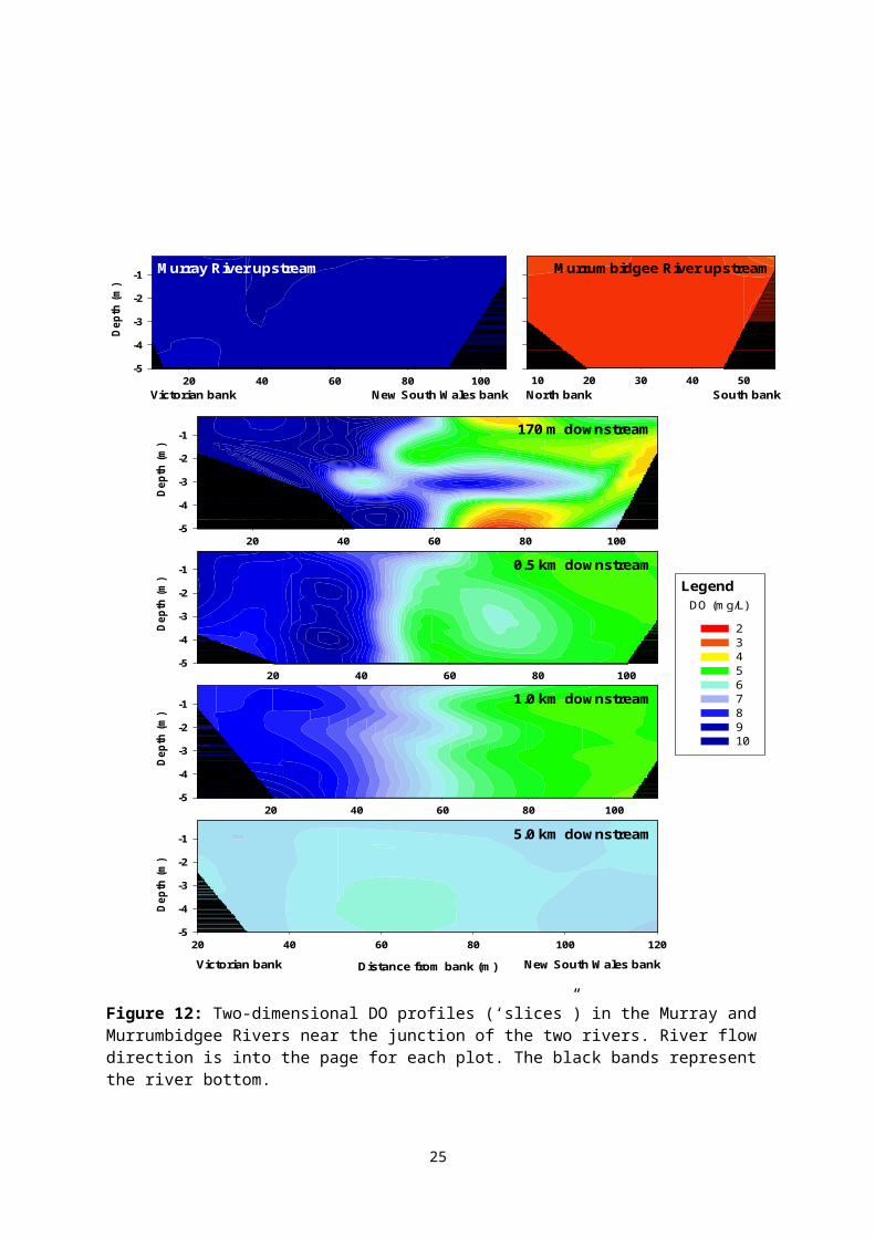
5.3 Mixing at the junction of the Murray and Murrumbidgee Rivers
An intense sampling program undertaken on 8 May 2012 allowed determination of the extent
of mixing of dilution water from the Murray River with hypoxic water from the
Murrumbidgee River at and downstream of the confluence. Based on depth profiles recorded
along each of six transects, two-dimensional DO profiles were produced for each site (Figure
12).
18

20 40 60 80 100
Dep
th (m
)
-5
-4
-3
-2
-1
10 20 30 40 50
Distance from bank (m)
20 40 60 80 100 120
Dep
th (m
)
-5
-4
-3
-2
-1
Murray River upstream Murrumbidgee River upstream
20 40 60 80 100
Dep
th (m
)
-5
-4
-3
-2
-1
20 40 60 80 100
Dep
th (m
)
-5
-4
-3
-2
-1
2345678 9 10
20 40 60 80 100
Dep
th (m
)
-5
-4
-3
-2
-1
Victorian bank New South Wales bank
South bankNorth bankVictorian bank New South Wales bank
170 m downstream
0.5 km downstream
1.0 km downstream
5.0 km downstream
LegendDO (mg/L)
Figure 12: Two-dimensional DO profiles (‘slices”) in the Murray and Murrumbidgee Rivers near the junction of the two rivers. River flow direction is into the page for each plot. The black bands represent the river bottom.
19

Dissolved oxygen in each river upstream of the junction was quite uniform across the channel
and with depth, albeit with markedly different levels of DO. Substantial mixing of the two
water bodies occurred within 170 m of the junction, although a plume of extremely hypoxic
water remained evident at the bottom of the channel. It is also evident that a continuous
corridor of well-oxygenated water persisted along the Murray River channel past the
Murrumbidgee junction. This would have allowed fish passage past the junction without
subjecting the fish to hypoxic conditions. Two distinct parcels of water remained evident up
to 4 km downstream of the junction (spot measurements at this point showed that DO levels
on either side of the river differed by about 2 mg/L – data not shown). Complete mixing had
occurred with 5 km downstream of the junction. Based on this survey, it is evident that data
from the logger located 5 river km downstream of the confluence is representative of DO
immediately after complete mixing of the two waterbodies.
5.4 Use of mixing models to predict DO and DOC
If DO downstream of a confluence is determined by simple mixing of the two flows, then:
DOds=( Fus× DOus )+( F inf × DO inf )
Fus+F infEquation 1
where: - DO is the concentration of dissolved oxygen in each water body
- F is the river discharge in each waterway
- Subscripts us, inf and ds refer to flow or DO upstream of the junction, in
the influent (dilution) water and downstream of the junction respectively.
This model can be applied to any other water quality parameter that is conservative upon
mixing (for example, DOC) by substituting for DO in Equation 1 the concentration of that
parameter.
We tested the accuracy of this model by applying it to data from the Murray River upstream
and downstream of the Wakool and Murrumbidgee River confluences during the 2012
blackwater event.
The measured DO upon mixing of the Murrumbidgee and Murray flows was compared to
that predicted using this mixing model. Dissolved oxygen data from the monitoring site
downstream of Balranald Weir was used to represent water quality in the Murrumbidgee
River at the Murray confluence and data from sites between the Murrumbidgee and Wakool
20

junctions (Below Wakool Junction, Heywood’s Inlet and Kenley D/S Wakool; averages used
where more than one value was collected on a single day) was used to represent the quality of
the Murray River dilution water. Measured DO data from sites immediately downstream of
the confluence (D/S Murrumbidgee, Narrung Wetlands, Boundary Bend) was used for
comparison with the model outputs. Calculations were only made for days where data was
available for all three regions. Discharge from Below Wakool Junction was used as the input
for Murray River upstream flow. The Murrumbidgee inflow was calculated as the difference
between discharge at Boundary Bend and at Below Wakool Junction (Murrumbidgee
discharge data from Balranald could not be used because some flow is lost on floodplains
between this site and the Murray confluence).
For the Wakool confluence, model inputs were: DO at sites above the Wakool junction
(Swan Hill, Tooleybuc, Nyah, Kenley U/S Wakool); DO in the Wakool River at Kyalite;
flow at Swan Hill and a calculated Wakool inflow based on the difference between discharge
at Swan Hill and at Below Wakool Junction (allowing a 2 day travel time). The model output
was compared with DO data from sites between the Wakool and Murrumbidgee junctions
(Kenley D/S Wakool; Below Wakool Junction; Heywood’s Inlet).
Date (2012)
Mar Apr May Jun
Dis
solv
ed o
xyge
n (m
g/L)
0
2
4
6
8
10
12
Measured DOCalculated DO
Measured DO (mg/L)
0 2 4 6 8 10 12
Cal
cula
ted
DO
(m
g/L)
0
2
4
6
8
10
12a) b)
Figure 13: Comparison of measured DO downstream of the Murrumbidgee junction with DO calculated using a simple mixing model.
Comparison of predicted and measured DO values downstream of the Murrumbidgee
confluence shows good agreement (Figure 13a). Regression of calculated against measured
values (Figure 13b) yields a good linear fit (r2 = 0.86; n = 18) with a slope not significantly
21
different from one (1.0117 ± 0.1003) and an intercept not significantly different from zero
(0.1198 ± 0.5426).
For the Wakool confluence, reasonable agreement was also obtained between measured and
calculated DO values (Figure 14a). Regression of calculated against measured values (Figure
14b) yields a good linear fit (r2 = 0.86; n = 16) but the slope is lower than expected
(0.7919 ± 0.0792) and the intercept is significantly greater than zero (1.5075 ± 0.5692). This
may be because of the greater distance between the upstream sampling points (e.g. Swan
Hill) and the confluence. Re-aeration or oxygen consumption processes in the reach between
the monitoring site and the confluence may have resulted in the DO at the confluence being
different to that used for the calculation. Use of data from a range of different sources
(MCMA spot measurements, Thiess Services spot measurements, NOW spot measurements,
logger daily averages) may also have affected the accuracy of the model outputs if some
meters were slightly out of calibration or if daily average values from the loggers differed
substantially from daytime spot measurements.
Date (2012)
Feb Mar Apr May Jun
Dis
solv
ed o
xyge
n (m
g/L)
0
2
4
6
8
10
12
Measured DOCalculated DO
Measured DO (mg/L)
0 2 4 6 8 10 12
Cal
cula
ted
DO
(mg/
L)
0
2
4
6
8
10
12a) b)
Figure 14: Comparison of measured DO downstream of the Wakool junction with DO calculated using a simple mixing model.
The mixing model was also applied to DOC data at the Murrumbidgee confluence, with DOC
concentrations at Weimby used as inputs for inflow DOC. Although only 5 data points were
available as model inputs, good agreement is shown between measured and predicted values
(Figure 15a). Regression of calculated against measured values (Figure 15b) yields a good
22

linear fit (r2 = 0.99; n = 5) with a slope close to one (1.0176 ± 0.1028) and an intercept not
significantly different from zero (-0.8130 ± 1.2294).
Date (2012)
23-Apr 07-May 21-May 04-Jun
Dis
solv
ed o
rgan
ic c
arbo
n (m
g/L)
0
5
10
15
20
Measured DOCCalculated DOC
Measured DOC (mg/L)
0 5 10 15 20C
alcu
late
d D
OC
(mg/
L)0
5
10
15
20a) b)
Figure 15: Comparison of measured DOC downstream of the Murrumbidgee junction with DOC calculated using a simple mixing model.
The success of the simple mixing model in predicting downstream DO and DOC immediately
after mixing hypoxic blackwater with diluent water indicates that it is reasonable to use this
model to predict the impact of changes in dilution flow volumes on downstream water
quality. We therefore use this model to demonstrate the impact of the environmental water
delivery on DO in the Murray River downstream of the Murrumbidgee confluence.
5.5 Impact of environmental water delivery on downstream DO
Using the dilution model we can test various scenarios of the impact of the environmental
water delivery on dissolved oxygen in the Murray River downstream of the confluence with
the Murrumbidgee River.
Dissolved oxygen in the Murray and Murrumbidgee Rivers are based on field measurements
with linear interpolation between sampling occasions. Flows in the Murrumbidgee were
estimated from the differences in flow in the Murray River between the Wakool Junction and
Boundary Bend. The estimate of the amount of environmental water at Boundary bend was
supplied to us by the the Murray-Darling Basin Authority based on MSM-Bigmod
algorithms. The flow modelling calculations consider only the change in flow as a result of
the releases ordered by CEWO. Any possible additional spill that may have subsequently
23

been created had the CEWO release not been made has not been considered (this is
equivalent to assuming that had the release volume water not been held by CEWO it would
have been previously diverted for irrigation). The Commonwealth environmental water
component of flow was calculated according to:
1. Route the observed releases from Hume downstream with actual releases and
diversions to produce a modelled estimate of flow at Euston.
2. Route the release from Hume net of CEWO release through the system under the
same conditions to produce a modelled estimate of flow at Euston without CEWO
release.
3. The difference between 1 and 2 gives the CEWO component of the flow at Euston.
4. Lag CEWO component of flow at Euston by 7 days to better match flow travel times
for this event.
5. Subtract values in 4 from actual Euston flow to give best estimate of Euston flow
without CEWO component.
Figure 16 shows modelled DO at daily time steps downstream of the Murrumbidgee River
confluence under three separate scenarios, no flow in the Murray River (black line), under
the worst case scenario of a base flow in the Murray River of 1800 ML/day (red line) and, a
base flows of 1800 ML/day plus the environmental water allocation. The modelling shows
that oxygen levels below the confluence would have been substantially worse at base flows of
1800ML/day without the environmental flows compared to base flows with the
environmental flow allocation. As it eventuated flows in the Murray River during the event
were much higher than projected under the worst case scenario and actual DO levels in the
Murray River downstream of the confluence were for the most part above the critical 4mg/L
level where biota begin to be impacted by poor water quality.
24

26 Mar 12 9 Apr 12 23 Apr 12 7 May 12 21 May 12 Mod
elle
d D
O @
Bou
ndar
y B
end
(mg/
L)
0
2
4
6
8No Murray R flows1800 ML/day1800 ML/Day + env water
Figure 16: Modelled DO downstream of the Murray River confluence with the Murrumbidgee under 3 scenarios – no water in the Murray River, a base flow of 1800 ML/day and, a flow of 1800 ML/day plus the additional environmental flows specifically delivered in 2012 to mitigate the effects of the hypoxic blackwater plume entering into the Murray River from the Murrumbidgee River.
6 Guiding principles for using environmental flows to mitigate
hypoxia caused by blackwater.
Environmental flows can be used to mitigate the effects of hypoxia caused by blackwater in
three ways:
1. As a dilution flow,
2. For the creation of oxygenated refugia
3. To slow the flood recession slowing the rate of floodwater entering a river channel.
25

In the first case sufficient water (of appropriate quality) is sourced from upstream to dilute
the hypoxic blackwater and hence mitigate downstream effects of hypoxia (this study). The
amount of dilution flows necessary will depend on the volume of the hypoxic blackwater, the
levels of dissolved oxygen in the dilution water, and the reactivity of carbon in the
blackwater. A model of the immediate and downstream effect of dilution flows based on
Equation 2 can be used to estimate the required dilution flow. In the second case, a plume of
oxygenated water is injected into a hypoxic stream to create a local oxygenated refuge for
aquatic organisms. This approach was used with some success in the 2010–11 blackwater
event in the Edward Wakool River system, where water from irrigation channel escapes was
used to create localised plumes of oxic water in an otherwise hypoxic environment.
Environmental water was also used in the 2012 event with the aim of the slowing the
recessing of floodwater off the Lowbidgee wetlands following the large flood. The primary
aim of that release was therefore to slow the rate of return flows – after the natural flood peak
had occurred – in order to keep the bank half full and slow the rate of return back into the
Murrumbidgee River channel and then the Murray River.
Whatever the purpose when deciding on whether or not to use environmental water to
mitigate hypoxia there are number of issues that need to be taken into consideration:
1. The source of blackwater. Knowledge of where the hypoxia is coming from will help
in the decision-making process. Assuming that the hypoxic blackwater originates
from a floodplain, estimates of floodplain return flow compared to current flows in
the receiving channel can be used to estimate likely effects (see below). Estimates of
the volume of water on the floodplain can be used to determine the likely duration of
the event.
2. The size of the receiving-water channel capacity. Overbanking of the channel
downstream of the source of hypoxic blackwater by dilution water will possibly
exacerbate the problem by mobilising new DOC from the riparian zone. Estimates of
the flow from upstream, the blackwater flow and the channel capacity puts an upper
limit on how much dilution flow can be delivered to mitigate the hypoxic event. The
blackwater dilution model can then be used to determine the potential effects of any
managed dilution flows.
3. Capacity and condition of the channel used for delivering the environmental flows. It
is preferable not exceed the capacity of the delivery channel when transporting
environmental flows for hypoxia mitigation, because overbank flows risk DOC
26

enrichment and DO depletion in the environmental flow water. If the channel used
for delivering environmental water is dry prior to commencement of flows, an
assessment of the risk of generating blackwater in the channel should be undertaken
(e.g. see Hladyz et al. 2011). This would require estimating the amount of litter on
the channel bed and comparing that with the amount of water (on a daily basis) that
will be passed down the channel. If the channel is a series of pools, an assessment of
the risk of lowering oxygen tension through mixing anoxic hypolimnetic water in any
stratified pools with the dilution flow should be undertaken.
4. Contingency planning: One of the key issues in using environmental water to
mitigate the impact of hypoxic blackwater is around the restraints within the system
to deliver the right amount of water in a timely fashion. Since the 2012 hypoxic
blackwater event a number of tools have been developed which have increased our
ability to predict and mange hypoxic blackwater. The first tool is an updated version
of the original blackwater model developed by the Murray–Darling Freshwater
Research Centre (Howitt et al. 2007). The original model specifically predicted
dissolved oxygen in the Murray and Edward Rivers downstream of Barmah Forest
and consisted of a fairly simple hydrological description of flooding of the forest
which was then used to calculate downstream oxygen and carbon levels in the two
rivers based on a series of process-based relationships. In order to update the original
model, the original process-based components of the model were deconstructed in
order to test the underlying assumptions in the model and refine the algorithms and
constants used in the calculations. The refined assumptions, constants and algorithms
were then supplied to the Murray–Darling Basin Authority (MDBA), who developed
a computational model which could interface with more robust hydrologic models,
including Bigmod and specific floodplain inundation models. This sophisticated
model not only can be used to predict the likelihood of hypoxia for the whole of the
Southern Connected Basin , but will also be a powerful tool for both predicting and
hind-casting energy movement from the floodplain to the river channel under various
flow scenarios.
The second tool developed in this project was a desktop planning tool to enable
managers to assess the benefits (specifically increased carbon for fish production)
and risks (hypoxia) of flooding floodplains. Like the original blackwater model, the
desktop Blackwater Risk Assessment Tool consists of a simple hydrologic model
27
coupled to a (now updated) process-based model. The third tool is a desktop module
designed to help managers assess the potential of a range of intervention options for
ameliorating the downstream impacts of hypoxic blackwater, if this is predicted to
occur.
Used together these tools present an opportunity to effectively manage water in the
basin to maximise the benefits associated with connecting a river to its floodplain
while minimising the potential disbenefits like hypoxia.
7 Conclusions
Discharge of hypoxic blackwater from the Murrumbidgee River system into the Murray
River during autumn 2012 had a negative impact on DO concentrations in the Murray River.
Examination of mixing patterns at and downstream of the junction revealed that complete
mixing of the hypoxic Murrumbidgee water with the Murray water occurred within
5 river km, and that a corridor of normoxic water persisted past the junction, which would
have facilitated the passage of biota . Dissolved oxygen concentrations in the Murray River
downstream of the Murrumbidgee junction could be predicted with reasonable accuracy
using a simple mixing model. This model shows that under the worst case scenario of a base
flow of 1800 ML/day, the environmental water allocation would have substantially improved
water quality downstream of the confluence of the Murray and Murrumbidgee Rivers.
8 Acknowledgements
Gordon Honeyman, Gerhard Schulz, Sarah McGeogh and others from NSW Office of Water;
Paula Robinson, Peter Kelly and others from the Mallee Catchment Management Authority;
and Stephen Petchell, Sue Hoffmann and others from Thiess Services collected samples
and/or supplied data for this project. Jim Foreman from the Murray-Darling Basin Authority
provided modelled flow data. Adrian Clements, David Wood, Braeden Lampard and Greg
Cranston assisted with field work and Brendan Curtin assisted with logistics. John Pengelly
analysed samples for dissolved organic carbon.
28

9 References
APHA (2005) Standard Methods for the Examination of Water and Wastewater, 21st ed.
American Public Health Association, Washington, D. C.
Australian Government Bureau of Meteorology (2012) Australian Climate Averages -
Rainfall. Retrieved 7/6/2012, from www.bom.gov.au.
Bren, L.J. (1992) Tree invasion of an intermittent wetland in relation to changes in the
flooding frequency of the River Murray, Australia. Australian Journal of Ecology 17(4),
395-408.
Gehrke, P.C. (1988) Response surface analysis of teleost cardio-respiratory responses to
temperature and dissolved oxygen. Comparative Biochemistry and Physiology Part A:
Physiology 89, 587-592.
Hladyz, S., Watkins, S.C., Whitworth, K.L. and Baldwin, D.S. (2011) Flows and hypoxic
blackwater events in managed ephemeral river channels. Journal of Hydrology 401, 117-125.
Howitt, J.A., Baldwin, D.S., Rees, G.N. and Williams, J.L. (2007) Modelling blackwater:
Predicting water quality during flooding of lowland river forests. Ecological Modelling 203
(3-4), 229-242.
Hutchinson, M.F., McIntyre, S., Hobbs, R.J., Stein, J.L., Garnett, S. and Kinloch, J. (2005)
Integrating a global agro-climatic classification with bioregional boundaries in Australia.
Global Ecology and Biogeography 14, 197-212.
King AJ, Tonkin Z, and Lieshcke J. (2012) Short-term effects of a prolonged blackwater
event on aquatic fauna in the Murray River, Australia: considerations for future events.
Marine and Freshwater Research 63, 576-586.
Kingsford, R.T. (2000) Ecological impacts of dams, water diversions and river management
on floodplain wetlands in Australia. Austral Ecology 25(2), 109-127.
Whitworth, K., Williams, J., Lugg, A. and Baldwin, D. (2011) A prolonged and extensive
hypoxic blackwater event in the southern Murray-Darling Basin. Final Report prepared for
29

the Murray-Darling Basin Authority by The Murray-Darling Freshwater Research Centre and
NSW DPI (Fisheries), MDFRC Publication 30/2011, June, 127 pp.
Whitworth, K.L., Baldwin, D.S. and Kerr, J.L. (2012) Drought, floods and water quality:
Drivers of a severe hypoxic blackwater event in a major river system (the southern Murray–
Darling Basin, Australia). Journal of Hydrology 450–451, 190-198.
Whitworth, K.L. and Baldwin, D.S. (2012) Blackwater in the southern Murray-Darling Basin
during 2012 flood events. Report prepared for the Murray-Darling Basin Authority by The
Murray-Darling Freshwater Research Centre, MDFRC Publication 16/2012, June, 34pp.
30