molino mills: the maritime cultural landscape of a
TRANSCRIPT

MOLINO MILLS: THE MARITIME CULTURAL LANDSCAPE OF A RECONSTRUCTION
ERA SAWMILL IN MOLINO, FLORIDA
by
Joseph James Grinnan
B.A., University of Florida, 2009
A thesis submitted to the Department of Anthropology
College of Arts and Sciences
The University of West Florida
In partial fulfillment of the requirements for the degree of
Master of Arts
2013

© 2013 Joseph James Grinnan

The thesis of Joseph James Grinnan is approved:
____________________________________________ _________________
Amy Mitchell-Cook, Ph.D., Committee Member Date
____________________________________________ _________________
Gregory D. Cook, Ph.D., Committee Member Date
____________________________________________ _________________
John Worth, Ph.D., Committee Chair Date
Accepted for the Department of Anthropology:
____________________________________________ _________________
John R. Bratten, Ph.D., Chair Date
Accepted for the University:
____________________________________________ _________________
Richard S. Podemski, Ph.D., Dean, Graduate School Date
iv
ACKNOWLEDGMENTS
This thesis was made possible through the generous support of the people and
organizations at the University of West Florida. I would like to thank my committee members
Dr. John Worth, Dr. Greg Cook, and Dr. Amy Mitchell-Cook for their insight, patience, and
editing assistance. Also, I would like to thank the faculty and staff of the departments of History
and Anthropology for all their guidance including Cindy Rodgers, Juliette Moore, Dr. John
Bratten, Dr. Ramie Gougeon, Norine Carroll, Janet Lloyd, Jennifer Melcher, Gabbi Grosse, and
Dr. John Clune. For the guidance, encouragement, and financial support of the Archaeology
Institute and Florida Public Archaeology Network including Dr. Elizabeth Benchley, John
Phillips, Karen Mims, Dr. Bill Lees, Dr. Della Scott-Ireton, Mike Thomin, and Cheryl Phelps, I
am especially grateful. I also owe many thanks to the staff at the UWF Marine Services Center:
Steve McLin, Fritz Sharar, and Del De Los Santos for their support, encouragement, and kind-
hearted entertainment.
The fieldwork necessary for this thesis depended heavily upon volunteers. These
individuals included Nicole Bucchino, Nicole Rosenberg-Marshall, Rachel Devan, Sarah
Hooker, Allen Wilson, Tara Giuliano, Colin Bean, Patricia McMahon, Jackie Rodgers, Eric
Swanson, Andy Derlikowski, Ben Wells, Danny Haddock, Cassie Vesper, Bill Lott, Marisa
Foster, Lauren Walls, Ryan Thompson, Colin, Keohane, Lindsey Cochran, Katie Brewer, Stacy
Marshal, Corinna Giles, Matt Gifford, John Krebs, Stephanie Dominici, Stewart Hood, Elaine
Nixon, Kevin Bender, Stephanie Poole, Bob Rutledge, Mark Vadas, Chris Dewey, Sarah
Bennett, Will Wilson, and Danny Allen. These individuals provided time and expertise essential
during the excavation of Molino Mills and I am deeply indebted to them.

v
The communities of Pensacola and Molino provided various types of assistance along the
way. Dean Debolt at UWF’s Special Collection in the John C. Pace Library assisted a great deal
locating sources of data. The Pensacola Archaeological Society and its members provided
financial support and encouragement. The Molino Historical Society and its members helped to
open up avenues of research as well as offer encouragement along the way.
Molino Mills sits on property owned by Mr. Richard Marlow. He generously allowed my
fellow UWF students and me to come onto his property and excavate the mill. His knowledge of
the local landscape and history of the lumber industry also guided my research and opened up
new avenues of research. I am grateful for him and his family for their assistance.
I would also like to thank my family: my mother and Phil for all their help and advice
throughout graduate school: dad and Maria for their support and guidance, and my grandparents
Papa Jim, Grandmother Mary sue, Gee, Roger, Poppy and Carole for their interest in my topic
and support. Finally, for the love of my life Nicole, not only did she help excavate the site and
edit my thesis, but her unwavering support and kindhearted nature were essential in the final
push to complete this thesis. I could not have completed this thesis without her by my side.
vi
TABLE OF CONTENTS
ACKNOWLEDGMENTS ................................................................................................. iv
LIST OF FIGURES .......................................................................................................... vii
ABSTRACT ....................................................................................................................... ix
CHAPTER I. INTRODUCTION ...........................................................................1
CHAPTER II. THEORETICAL FRAMEWORK ...................................................5
CHAPTER III. HISTORICAL CONTEXT ............................................................20
A. West Florida Lumber Industry .................................................20
B. History of Molino, Florida .......................................................31
CHAPTER IV. METHODOLOGY ........................................................................48
A. Terrestrial .................................................................................48
B. Conservation ............................................................................52
C. Maritime ...................................................................................53
D. Historical Research ..................................................................57
CHAPTER V. RESULTS ......................................................................................60
A. Terrestrial Fieldwork Results ...................................................60
B. Artifact Discussion...................................................................67
C. Features ....................................................................................69
D. Extant Structures: Structure 1 ..................................................75
E. Structure 2 ................................................................................77
F. Structure 3 ................................................................................79
G. Maritime Fieldwork Results ....................................................81
CHAPTER VI. CONCLUSION ..............................................................................88
REFERENCES ................................................................................................................102
APPENDIX ......................................................................................................................115
A. Table of Artifacts Recovered .................................................116

vii
LIST OF FIGURES
1. Corliss Compound Engine located in Pawtucket R.I. ............................................25
2. A typical lengthwise section of a cylinder from a Corliss engine. ........................26
3. Two views of the prototype of the modern high-speed engine. .............................27
4. This is a fully developed sectional watertube boiler from the late nineteenth
century....................................................................................................................28
5. Only known image of Molino Mills. .....................................................................46
6. UWF Combined Terrestrial and Maritime Fieldschool students recording the
trench/sluiceway exposed by low water levels. .....................................................54
7. UWF Combined Terrestrial and Maritime Fieldschool students using
trilateration to record submerged pilings in the Escambia River. ..........................55
8. Dr. John Worth and the author performing a magnetometer survey in the
Escambia River. .....................................................................................................56
9. Aerial view with all units excavated by April 2012 at Mission San Joseph de
Escambe/Molino Mills site (8ES3473). .................................................................61
10. Graphic display demonstrating relative elevation changes in mNAVD88
of Durants Bluff. ....................................................................................................62
11. Close-up aerial view of units targeting Molino Mills. ...........................................62
12. South wall profile of ST 255. .................................................................................63
13. South wall profile of ST 257. .................................................................................64
14. North wall profile of ST 258. .................................................................................65
15. Close-up aerial view of units targeting Molino Mills including the
approximate mill boundary. ...................................................................................66
16. Plain whiteware cup rim found in level 21
(2.199mNAVD88-2.10mNAVD88) of ST 259. ....................................................68
17. “J. Gonzalez” brick found at Molino Mills. ...........................................................69
18. Structure 1 looking northeast. . ..............................................................................75

viii
19. Hand drawn sketch looking down at structure 1. ...................................................76
20. Photograph of structure 2 looking north. ..............................................................78
21. Photographs of structure 3. Styles A, B, and C are left to right. ...........................80
22. Scale drawing of structure 3 demonstrating the relative locations of the bolts. ....80
23. Image of trench/sluiceway looking east. ................................................................82
24. Aerial view of Molino displaying contoured data from the magnetometer
survey area. ............................................................................................................84
25. Colored contoured survey data.. ............................................................................85
26. Hand drawn sketch of MMM20 and MMM21.. ....................................................86

ix
ABSTRACT
MOLINO MILLS: THE MARITIME CULTURAL LANDSCAPE OF A RECONSTRUCTION
ERA SAWMILL IN MOLINO, FLORIDA
Joseph James Grinnan
The economic disposition of Molino, Florida, depended on the prosperity of its
industries. The lumber industry was the major determinant in the rise or fall of the city for much
of the nineteenth century. The largest of these sawmills was a steam-powered mill aptly named
Molino Mills. In 1866, a group of wealthy entrepreneurs built Molino Mills in the hopes of
tapping into West Florida’s lush, yellow pine forests. The mill is situated on the banks of the
bustling Escambia River in the westernmost portion of Florida; however, the mill itself is not
limited to its terrestrial components. Documentary research has revealed a maritime aspect in
the culture surrounding the lumber industry, while riverine archaeological investigations have
uncovered several structural features that extend into the river. Analysis of terrestrial and
maritime fieldwork as well as primary documents delves into the maritime resources surrounding
this Reconstruction Era sawmill. The analysis provides a unique viewpoint from which to
examine Molino Mills and the West Florida lumber industry.

1
CHAPTER I
INTRODUCTION
Early in West Florida’s colonial history, prospectors looked at the land’s vast timber
resources and described the wealth that could be garnered from exploiting its forests. Colonists
utilized water-powered mills to process felled timber and prepare it for personal, as well as
commercial, use. Until the early twentieth century, the forests of West Florida were rich in
southern yellow pine. The demand for these pines trees became greater and greater as time
progressed from the Colonial Era until the twentieth century. Unfortunately, most sawmills in
West Florida ceased to operate during the Civil War, some destroyed during raids or burned by
retreating forces. However, immediately following the war, there was a significant boom in
yellow pine production. It is at this point, during Florida’s Reconstruction Era, that Molino Mills
was built and became one of the largest mills in West Florida and, possibly, the Southeast.
A group of wealthy northern entrepreneurs purchased the land for Molino Mills in
January of 1866.1 The men selected a small community about 25 miles (40 kilometers) north of
Pensacola along the bank of the Escambia River. Milling was not a new concept to the
community as it once contained the water-powered Cooper mill in operation from the mid-1830s
until the Civil War. The community became known as Molino and was a strategic location for a
milling operation. Florida’s Escambia River, referred to as the Conecuh River once it crosses the
Alabama border, travels some 250 miles from its source until it drains into Pensacola Bay.
Molino sits at an important point in the river just before it changes course and the river banks
become extremely swampy. Bankrupt in 1875, the mill was sold to another wealthy northerner
who revamped and reinvigorated the mill, likely initiating its heyday. In 1881, local lumber
1 Escambia County, Deed Book P, Escambia County Deed Records, Escambia County Clerk of Circuit
Court and Comptroller Archives, Pensacola, FL, 581-585.

2
baron Daniel F. Sullivan purchased and operated the mill until a fire destroyed it on September 7,
1884.
The investigation into Molino Mills began as a class project concerning historical
documents. This project sparked my interest, eventually becoming the foundation for this thesis.
As the thesis evolved, three research goals developed: first, to determine the mill’s boundary and
document the extant remains; second, to investigate the connection between Molino Mills and
the Escambia River; and, finally, to determine the importance of Molino Mills in the West
Florida lumber industry.
In order to investigate these research goals, three separate phases were initiated. The first
phase required terrestrial fieldwork. Over an eight month period, students from the University of
West Florida excavated 15 test units and documented three extant structures. The collected
archaeological assemblage provides a detailed record of life surrounding a mid-nineteenth
century steam-powered sawmill, while examined structures illustrate the inner workings of the
mill and how laborers operated the machinery.
To explore the connection between the Escambia River and Molino Mills, students from
the University of West Florida conducted a pedestrian survey and magnetometer survey, diving
on identified anomalies. Maritime fieldwork located and documented a number of previously
unknown structures related to Molino Mills that exist either submerged or semi-submerged in the
Escambia River. The results of fieldwork in conjunction with historical documents tell a
fascinating story linking Molino Mills and the Escambia River.
Documents were the most significant source utilized to determine the relative importance
of Molino Mills. Few documents concerning Pensacola’s Reconstruction Era have survived to
the present day: many burned in a downtown Pensacola fire during the 1880s, while those

3
directly related to Molino Mills likely burned in 1884 with the mill itself. Still, from the few
documents that have survived, a detailed history can be told of West Florida’s post-Civil War
lumber industry.
Most studies into West Florida’s lumber industry have examined antebellum water-
powered sawmills or turn of the twentieth century mill company towns. Molino Mills is a
unique site in that it operated almost exclusively during the Reconstruction Era, providing an
excellent opportunity to look at an early (in terms of West Florida) steam-powered sawmill in a
poorly understood timeframe of the industry. Additionally, sawmill studies typically focus on
either the main mill building or the mill worker’s residences. Although the aforementioned
resources are some of the best ways to investigate the lumber industry, they often overlook other
resources integral to the lumber production process, like transportation. A major aspect of the
examination into Molino Mills is the transportation aspect, especially when considering the
intricacies of lumber transportation via the Escambia River.
Chapter two lays a foundation for the entire thesis by detailing the theory of maritime
cultural landscapes and, to a lesser degree, historical ecology. Maritime cultural landscape
theory denotes a perspective from which to view Molino Mills, while historical ecology
establishes the chronological timeframe in which to observe the lumber industry. This thesis is
the first instance in which these theoretical paradigms have been applied to a sawmill. History is
the main theme of chapter three. The chapter begins by portraying an in-depth history of the
West Florida lumber industry, as well as the evolution of the steam engine, then providing a
history of the community of Molino and a detailed property record for the mill site itself.
Chapter three ends with a narrative of the history of Molino Mills gathered from numerous
primary and secondary sources. Chapter four outlines the archaeological methodology employed

4
at the Mission San Joseph de Escambe/Molino Mills site. It begins by describing the previous
archaeological work done primarily at the mission site and ends with the specific methods
utilized during both the terrestrial and maritime portions of the investigation targeting Molino
Mills. The results of both terrestrial and maritime fieldwork are described in chapter five. The
terrestrial results are broken down between the excavation and documentation of extant
structures, while maritime work is illustrated in one continuous narrative. The final chapter
provides an analysis of the fieldwork and archival results framed by the theoretical paradigm
outlined in chapter two.
This thesis is significant in a number of ways: first, it examines an often overlooked, yet
important, period in the development of West Florida lumber industry. Not only does it examine
an era on which little research has been conducted, but the evidence which was recovered and
detailed in the subsequent chapters hints that Molino Mills may have been a transitional mill.
Thus, Molino Mills does not fit into traditional mill classifications and may be an early precursor
to large company towns common at the turn of the twentieth century. Additionally, submerged
resources have been one of the major foci of this project. While many scholars have studied
steam-powered sawmills and the lumber industry, only a few have discussed or documented
submerged or semi-submerged structures associated with the lumber industry. One of the major
focuses of this thesis is, therefore, submerged and semi-submerged structures. Finally, this thesis
is unique in that it is the first example of a sawmill being viewed through the lens of the
maritime cultural landscape, providing a new and innovative approach with which to analyze
industrial resources by viewing them from a maritime perspective

5
CHAPTER II
THEORETICAL FRAMEWORK
Liminal locations such as waterfronts and inland waterways are often overlooked by
archaeologists. These areas are neither completely reliant on terrestrial nor maritime means for
their survival and thus these spaces do not directly reside under the realm of either the terrestrial
or maritime archaeologist. Early in the history of maritime archaeology, some archaeologists
like Keith Muckelroy believed that maritime archaeology did not include coastal resources;
instead, he argued that groups associated with these resources are “more closely related to
surrounding communities in their material culture…display[ing] their maritime connections only
marginally.”1 Yet, when archaeologists utilize both terrestrial and submerged resources in
conjunction with available historical documents, a more holistic understanding of the liminal
space, whether it be site specific or over a broad geographic area, can be inferred. Maritime
archaeologists over the past 20 years have been developing and refining a theoretical framework
that incorporates both terrestrial and underwater resources to create broad, overarching
understandings of past populations and their experiences. These studies are significant because
they redefine how archaeologists interpret maritime culture. J. R. Hunter notes this significance
when he states that “One of the great achievements of maritime archaeology…has been in
demonstrating that the contexts of coastal and island sites are maritime as well as terrestrial.”2
Christer Westerdahl coined the phrase “maritime cultural landscape” to describe “the
whole network of sailing routes, old as well as new, with ports and harbours along the coast, and
1 Keith Muckelroy, Maritime Archaeology (Cambridge: Cambridge University Press, 1978), 6.
2 J.R. Hunter, “’Maritime Culture’: Notes from the Land,” The International Journal of Nautical
Archaeology 23, no. 4 (1994): 261.

6
its related construction and remains of human activity, underwater as well as terrestrial.”3 In the
early 1990s, this was a revolutionary notion because it recognized that maritime archaeology
does not end at the shoreline; instead, the maritime milieu should be examined from both
maritime and terrestrial contexts. A method to conceptualize and link these resources is through
what Westerdahl calls a “transit point.” A transit point exists at “connections with waterways
inland and points where vessel or transportation methods change.”4 Such points include where a
river flows into a lake, or where roads or railways intersect with the coast, estuaries, or ferry
locations. These points are, from an economic and geographic standpoint, the zones connecting
the entire system together and “must be taken into account if the maritime cultural landscape is
to be understood properly.”5
Westerdahl illustrates five types of archaeological resources that constitute a maritime
landscape: shipwrecks, land remains, the study of natural topography, tradition of usage, and
place names.6 The first two types consist of the physical remnants of human occupation and
their culture including both underwater, the former, and terrestrial, the latter. According to
Westerdahl, shipwrecks are the primary indicators of age and, potentially, the only means of
dating an assemblage of cultural material.7 Terrestrial sites, on the other hand, provide clues to
the activities that occurred in a given geographic region. These activities are often associated
3 Christer Westerdahl, “The Maritime Cultural Landscape,” The International Journal of Nautical
Archaeology 21, no. 1 (1992): 6.
4 Ibid., 6-7.
5 Christopher E. Horrell, “Plying the Waters of Time: Maritime Archaeology and History on the Florida
Gulf Coast” (PhD diss., Florida State University, 2005), 14; Westerdahl, “The Maritime Cultural Landscape,” 6.
6 Westerdahl, “The Maritime Cultural Landscape,” 7-9.
7 Ibid., 7-8.

7
with what one may consider an inherently maritime activity such as fishing or navigation or, for
instance, artifacts recovered from a lighthouse or other structure that exists on land.
The third category pertains to the natural topography or characteristics inherent to the
land itself. Westerdahl uses the characteristics of natural havens such as perfect lagoons to
describe maritime culture and its use of the natural environment.8 However, he neglects to
discuss how humans have modified the natural environment in favor of some activities like, for
instance, harbor modifications to enhance or protect shipping. Still, topographic features such as
water depth, barrier islands, bends in the river, and elevation changes do provide insight into how
or why sites were utilized.
Tradition and usage, as well as place names, incorporate information from both archival
research and ethnographic data to draw conclusions. Westerdahl believes that, through the
“mental map” contained within local informants, archaeologists are able to look backward
through time at routes and trade networks utilized by humans centuries ago. Place names may
include areas such as ship blockages, shipwrecks themselves, or repair sites and their resources.9
These names represent the cultural milieu of a society and demonstrate people’s mental
representations and interpretations of the landscape, while also identifying significant activity
areas.
Archaeological studies into maritime cultural landscapes originate in locales from around
the globe, yet the bulk of these studies have been conducted in Europe.10
Still, many studies
8 Westerdahl, “The Maritime Cultural Landscape,” 8-9.
9 Ibid,. 8-9.
10
Alan Aberg and Carenza Lewis, eds. The Rising Tide: Archaeology and Coastal Landscapes (Oxford,
UK: Oxbow Books, 2000); Matesuez Bogucki, “Viking Age Ports of Trade in Poland,” Estonian Journal of
Archaeology 8, no. 2 (2004): 100-122; Anders Fischer, “Coastal Fishing in Stone Age Denmark - Evidence from
Below and Above the Present Sea Level and from Human Bones,” in Shell Middens in Atlantic Europe, ed. Nicky

8
have also been completed in Australia and Africa.11
Only recently has maritime cultural
landscape (MCL) research become popular in North America.12
Worldwide, a wide array of
Milner, Oliver E. Craig, and Geoffrey N. Bailey (Hampshire, UK: Oxbow Books, 2007), 54-69; Joe Flatman,
“Cultural biographies, cognitive landscapes and dirty old bits of boat: ‘theory’ in maritime archaeology,” The
International Journal of Nautical Archaeology 32, no. 2 (2003): 143-157; Wes Forsythe, “Bantry Bay, County Cork,
a Fortified Maritime Landscape,” Historical Archaeology 41, no. 3 (2007): 51-62; Audrey J. Horning, “On the
Banks of the Bann: The Riverine Economy of an Ulster Plantation Village,” Historical Archaeology 41, no. 3
(2007): 94-114; Hunter, “’Maritime Culture,’”261-264; Kristin Ilves, “The Seaman’s Perspective in Landscape
Archaeology,” Estonian Journal of Archaeology 8, no. 2 (2004): 162-177; Marika Mägi, “’...Ships are their main
strength.’ Harbour sites, Arable Lands and Chieftains on Saaremaa,” Estonian Journal of Archaeology 8, no. 2
(2004): 128-155; Marika Mägi, “Maritime Landscapes: Introduction,” Estonian Journal of Archaeology 8, no. 2
(2004): 93-96; N. Marriner and C. Morhange, “Geoscience of Ancient Mediterranean Harbors,” Earth-Science
Reviews 80 (2007): 137-194; Thomas McErlean, “Archaeology of the Strangford Lough Kelp Industry in the
Eighteenth and Early Nineteenth Centuries,” Historical Archaeology 41, no. 3 (2007):76-93; Thomas McErlean et
al., “The Sequence of Early Christian Period Horizontal Tide Mills at Nendrum Monastery: An Interim Statement,”
Historical Archaeology 41, no. 3 (2007): 63-75; Thomas McErlean, Rosemary McConkey, and Wes Forsythe,
Strangford Lough: An Archaeological Survey of the Maritime Cultural Landscape (Belfast, Northern Ireland:
Blackstaff Press, 2003); Aidan O'Sullivan, “Intertidal Archaeological Surveys in the Estuarine Wetlands of North
Munster,” The International Journal of Nautical Archaeology 24, no. 1 (1995): 71-73; Aidan O'Sullivan, “Place,
Memory and Identity among Estuarine Communities: Interpreting the Archaeology of Early Medieval Fish Weirs,”
World Archaeology 35, no. 3 (2004): 449-468; Aidan O'Sullivan and Colin Breen, Maritime Ireland: An
Archaeology of Coastal Communities (Gloucestershire, UK: Tempus, 2007); Dietlind Paddenberg and Brian
Hession, “Underwater Archaeology on Foot: A Systematic Rapid Foreshore Survey on the North Kent Coast,
England,” The International Journal of Nautical Archaeology 37, no. 1 (2008): 142-152; A. J. Parker, “A Maritime
Cultural Landscape: The Port of Bristol in the Middle Ages,” The International Journal of Nautical Archaeology 28,
no. 4 (1999): 323-342; Johann Rönnby, “Maritime Durées: Long Term Structures in a Coastal Landscape,” Journal
of Maritime Archaeology 2, no. 2 (2007): 65-82; Robert Van de Noort and Aidan O'Sullivan, Rethinking Wetland
Archaeology (London, UK: Gerald Duckworth and Company, 2006); Christer Westerdahl, “Maritime Cultures and
Ship Types: Brief Comments on the Significance of Maritime Archaeology,” The International Journal of Nautical
Archaeology 23, no. 4 (1994): 265-270.
11
Aiden Ash, The Maritime Cultural Landscape of Port Willunga, South Australia, Flinders University
Maritime Archaeology Monographs Series, no. 4 (Adelaide: Shannon Research Press, 2007); Colin Breen and Paul
J. Lane, “Archaeological Approaches to East Africa's Changing Seascapes,” World Archaeology 35, no. 3 (2003):
469-489; Brad G. Duncan, “The Maritime Archaeology and Maritime Cultural Landscapes of Queenscliffe: a
Nineteenth Century Australian Coastal Community” (PhD diss., James Cook University, 2006); Veronica M.
Morriss, “Islands in the Nile Sea: The Maritime Cultural Landscape of Thmuis, an Ancient Delta City” (master’s
thesis, Texas A&M University, 2012); Andrea Smith, “The Maritime Cultural Landscape of Kangaroo Islands,
South Australia: A Study of Kingscotie and West Bay” (master’s thesis, Flinders University, 2006).
12
James Delgado, Frederick H. Hanselmann, and Dominique Rissolo, “The ‘Richest River in the World’:
The Maritime Cultural Landscape of the Mouth of the Río Chagres, Republica de Panamá,” in The Archaeology of
Maritime Landscapes, ed. Ben Ford (New York: Springer, 2011), 233-246; Jeffery B. Glover, Dominique Rissolo,
and Jennifer P. Matthews, “The Hidden World of the Maritime Maya: Lost Landscapes Along the North Coast of
Quintana Roo, Mexico,” in The Archaeology of Maritime Landscapes, ed. Ben Ford (New York: Springer, 2011),
195-216; Horrell, “Plying the Waters of Time”; Krista Jordan-Greene, “A Maritime Landscape of Deadman’s Island
and Navy Cove” (master’s thesis, University of West Florida, 2007); Kendra Kennedy, “Between the Bayous: The
Maritime Cultural Landscape of the Downtown Pensacola Waterfront” (master’s thesis, University of West Florida,
2010); Jennifer F. Mckinnon, “Maritime Cultural Landscapes: Investigations at the Spanish Landing (8Wa247)”
(master’s thesis, Florida State University, 2002); David J. Steward, “Gravestones and Monuments in the Maritime

9
sites and resources have been analyzed through the lens established by Westerdahl. Not
surprisingly, most studies have taken a large landscape, such as that of a coastal settlement, and
explored the area’s immediate connection to the sea, commonly through fishing communities
and significant ports.13
Unfortunately, many of these studies focus exclusively on the land-based
resources to the exclusion of submerged or semi-submerged cultural resources.
Other archaeologists have instead chosen to inspect a particular aspect or artifact from a
coastal setting, such as monuments or fish weirs, and examine their place on the maritime
landscape.14
In addition, a few studies have broken away from the focus on coastal settlements
and moved further inland to examine lakes that exist great distances from the open ocean but do,
in fact, display cultural parallels with human settlement located at the ocean’s edge.15
Even
fewer studies have made the leap to the riverine environment and have attempted to establish the
presence of maritime culture in a riverine setting.16
This study follows this last example,
endeavoring to examine Molino and Molino Mills as a transit point along the Escambia River
and explain the existence of a maritime culture in the area.
Cultural Landscape: Research Potential and Preliminary Interpretations,” The International Journal of Nautical
Archaeology 36, no. 1 (2007): 112-124.
13
Ash, The Maritime Cultural Landscape of Port Willunga, South Australia; Parker, “A Maritime Cultural
Landscape.”
14
Steward, “Gravestones and Monuments in the Maritime Cultural Landscape”; Nigel Bannerman and
Cecil Jones, “Fish-trap Types: a Component of the Maritime Cultural Landscape,” The International Journal of
Nautical Archaeology 28, no. 1 (1999): 70-84.
15
Benjamin Ford, “Lake Ontario Maritime Cultural Landscape” (PhD diss., Texas A&M University,
2009); K.J. Vrana and G.A. Vander Stoep, “The Maritime Cultural Landscape of the Thunder Bay National Marine
Sanctuary and Underwater Preserve,” in Submerged Cultural Resource Management: Preserving and Interpreting
Our Sunken Maritime Heritage, eds. J.D. Spirek and D.A. Scott-Ireton (New York: Springer, 2003), 17-28; Christer
Westerdahl, “Maritime Culture in an Inland Lake?,” in Maritime Heritage, eds. C.A. Brebbia and T. Gambin
(Southampton, UK: WIT Press, 2003), 17-26.
16
Kimberly Esser, “Inland Waterways of the California Delta: Identifying and Managing a Maritime
Landscape,” in Underwater Archaeology, eds. Adriane Askins Neidinger and Matthew A. Russell (Tucson, AZ:
Society for Historical Archaeology, 1999),17-20; Gurly Vedru, “People on River Landscapes,” Estonian Journal of
Archaeology 8, no. 2 (2004): 181-198.

10
Westerdahl’s development of MCL revolutionized how archeologists view the shoreline,
but, recently, some have criticized MCL, stating inadequacies in its ability to examine maritime
culture.17
This critique has spurred further refinement to the theoretical paradigm. For instance,
Christopher Horrell suggests that MCL is problematic for American archaeologists because,
while it is successful in changing how archaeologists view maritime or terrestrial contexts, it
focuses solely on points of interaction or transit points and fails to provide or describe the
mechanism(s) necessary for analyzing human interaction and exchange.18
Essentially, Horrell
feels that MCL, as described by Westerdahl in the 1990s, is merely a descriptive tool, rather than
an analytical one. Kendra Kennedy also critiques MCL in her statement that the “…general lack
of explicit theory in MCL studies is unfortunate because the use of a landscape framework
allows for more than just an inventory of local resources.”19
The first endeavor to improve upon MCL stems from the writings of Anthony Firth.20
Firth utilizes the archaeology of practice to build upon the foundation of MCL, thereby
combining a descriptive tool with an analytical one. Drawing from the work of Anthony
Giddens, Firth utilizes what Giddens termed a “locale.”21
Locale refers to the setting in which an
individual’s actions and reactions occur. It is an integral part of any archaeological study
because it “identifies material culture as an active medium of social reproduction rather than as a
17
Horrell, “Plying the Waters of Time,”15; Hunter, “’Maritime Culture,’” 261-262; Kennedy, “Between
the Bayous,” 8; David Berg Tuddenham, “Maritime Cultural Landscapes, Maritimity and Quasi Objects,” Journal of
Maritime Archaeology 5, no. 1 (2010): 5-16.
18
Horrell, “Plying the Waters of Time,” 15.
19
Kennedy, “Between the Bayous,” 8.
20
Antony Firth, “Three Facets of Maritime Archaeology: Society, Landscape, Critique” (Southhampton,
UK: University of Southhampton Department of Archaeology), 1995.
21
Antony Firth, “Three Facets of Maritime Archaeology: Society, Landscape, Critique” (Southhampton,
UK: University of Southhampton Department of Archaeology), 1995; Anthony Giddens, Central Problems in Social
Theory: Action, Structure and Contradiction in Social Analysis (London: Macmillan, 1979), 206-207.

11
passive backdrop.”22
The concept of locale is applicable to a wide array of settings, from site
specific to broad landscapes, and aids in drawing connections between human behavior and the
natural environment. In this regard, Giddens had developed an analytical tool capable of linking
society and the natural landscape.
Giddens’s tool consists of a four step process, the first step relates to the ‘social space,’ or
location in which a group is associated, while the second details the legitimization of a group’s
use of space. The third step examines the social system and the institutions that comprise the
social system, while the final step appraises how individuals’ view themselves within the social
hierarchy.23
Firth explains that, through the concept of locale and the four analytical tools
described above, it is possible to uncover the underlying facets of a maritime society or, in other
words, to identify the social practices that structure a society.24
Firth succeeds in demonstrating that it is necessary to employ a structural framework
when investigating maritime societies. Such a framework creates the ability for the application
of a flexible maritime label. A society whose whole existence does not revolve around maritime
resources, but rather relies on certain aspects of the marine environment and is thus only partially
a maritime society, would be an example of a flexible label. Firth, however, like Westerdahl,
fails to define exchange and interaction occurring at locales, while also neglecting the
mechanisms that reveal changes in community practice. He, again like Westerdahl, places a
22
Antony Firth, “Three Facets of Maritime Archaeology: Society, Landscape, Critique” (Southhampton,
UK: University of Southhampton Department of Archaeology), 1995.
23
Anthony Giddens, A Contemporary Critique of Historical Materialism, Vol. 1: Power, Property and the
State (London: Macmillan 1981), 45-46.
24
Antony Firth, “Three Facets of Maritime Archaeology: Society, Landscape, Critique” (Southhampton,
UK: University of Southhampton Department of Archaeology), 1995.

12
significant emphasis on the environment’s effect on society at the expense of describing societal
changes and their influence on the way society evolves.
Christopher Horrell’s answer to the shortcomings of MCL was to develop a new model
that he terms “The Maritime Economic and Socio-Cultural Relations Model.”25
This model aims
to provide an interpretative framework for comprehending the interactions and exchanges that
occur, both at transit points as well as within a maritime society. In order to develop this
comprehensive framework, Horrell combines the concepts of economy as a social institution, the
labor theory of value, and world-systems theory.26
In the concept of economy as a social institution, Horrell first chronicles the history and
development of what an “institution” is using research from previous studies like those of
Parsons, Levi, Giddens, Bourdieu, and Douglas.27
Thus, Horrell explains that a society is
composed of individual interactions with each other as well as their interactions with an
institution, where the institution is the legitimized structural framework within which a society is
derived.28
In Horrell’s model, the social institution has taken the form of the economy, an
institution that allows for a diachronic examination into a particular locale’s market economy.
25
Horrell, “Plying the Waters of Time,” 18.
26
Ibid., 18.
27
L.J. Levi, “An Institutional Perspective on Prehispanic Maya Residential Variation: Settlement and
Community at San Estevan, Belize,” Journal of Anthropological Archaeology 21 (2001): 120-141; T. Parsons, The
Social System (New York: The Free Press, 1951); Anthony Giddens, The Constitution of Society: Outline of the
Theory or Structuration (Berkeley: University of California Press, 1984); Pierre Bourdieu, Outline of A Theory of
Practice (Cambridge: Cambridge University Press, 1972); Pierre Bourdieu, The Logic of Practice (Stanford, CA:
Stanford University Press, 1990); Mary Douglas, How Institutions Think (Syracuse, NY: Syracuse University Press,
1986).
28
Horrell, “Plying the Waters of Time,” 19-23.

13
The next aspect of the maritime economic and socio-cultural relations model is the labor
theory of value, which is derived from the work of Karl Marx.29
Horrell believes that the labor
theory of value is essential to the study of the economy because it provides the ability to
investigate the significance of labor to the development of a community.30
To complete an
examination into the labor theory of value, archaeologists must explore the elements of
capitalism, including commodity, value, labor, exchange, and consumption. These elements are
uniquely intertwined: a commodity (such as raw material or labor) is exchanged following the
establishment of its perceived value in the minds of the individuals who comprise a given
society. The consumption of goods occurs both before and after exchange. Prior to exchange,
certain commodities are consumed during the production of other commodities, as well as the
individual’s consumption of a good following an exchange. This cycle of consumption during
production, exchange, and consumption following exchange depicts labor and its value within
the economic market, as well as its significance to the social institution.31
Horrell states that the
labor theory of value is integral to his model because it “will aid in teasing out the importance of
maritime labor to these communities as well as facilitating a greater understanding of the socio-
cultural processes occurring within these communities and the surrounding region based on their
economies.”32
The framework developed by world systems theory and its tenets as described by
Immanuel Wallerstein provide the structure that allows the labor theory of value to be applied on
29
Karl Marx, Capital: A Critique of Political Economy (New York: Penguin Classics, 1992).
30
Horrell, “Plying the Waters of Time,” 24.
31
Ibid., 24-27; D. Graeber, Toward an Anthropology of Value: The False Coin of Our Own Dreams (New
York: Palgrave, 2001), 55.
32
Horrell, “Plying the Waters of Time,” 24.

14
a regional, national, and global level.33
Wallerstein uses the exploitative nature of cores, semi-
peripheries, and peripheries to express interaction in both a social and economic setting. This
conceptual tool can be used to understand the morphology of a developing society and how it
evolves through time and space.34
Horrell also incorporates Nicholas Kardulias’s idea of
“negotiated periphery” to demonstrate an individual’s actions and decision-making ability within
a society, thus revealing links between people and the system.35
The Maritime Economic and Socio-Cultural Relations Model integrates the concepts of
economy as a social institution, the labor theory of value, and world-systems theory, where the
labor theory of value is necessary to comprehend the social and cultural processes within the
economy of a social institution. The patterns resulting from these processes are then teased out
through the framework defined in world systems theory. Through the integration of these three
concepts, in conjunction with an analysis of archaeological data and historical documents,
Horrell claims that archaeologists are able to provide an anthropological look into maritime
society. 36
Kendra Kennedy chose a different route than Horrell in her endeavor to build upon the
framework of MCL. She utilized MCL as a base for pondering questions concerning gender,
ideology, ethnicity, power, resistance, and agency.37
The focus of her study relies on the works
33
Horrell, “Plying the Waters of Time,” 28; Immanuel Wallerstein, The Modern World-system: Capitalist
Agriculture and the Origins of the European World Economy in the Sixteenth Century (New York: Academic Press,
1974).
34
Horrell, “Plying the Waters of Time,” 28-29.
35
Ibid., 31; Nicolas Kardulias, ed., World Systems Theory in Practice: Leadership, Production, and
Exchange (Lanham, MD: Rowman and Littlefield, 1999).
36
Horrell, “Plying the Waters of Time,” 34.
37
Kennedy, “Between the Bayous,” 18.

15
of Pierre Bourdieu and Anthony Giddens on habitus, practice, and structuration as they relate to
human agency.38
Kennedy explains that an individual’s habitus is composed of their past
experiences, where they have learned which actions and reactions are appropriate for a given
situation. It is from these experiences that an individual’s practice is manifested.39
Structuration, in this instance, is defined as the way practices “both create and are created by
practice itself.”40
The three components of habitus, practice, and structuration form the
framework which describes human agency. From an examination into the factors which
comprise human agency on the waterfront, Kennedy believes it is possible to understand aspects
of an individual’s agency, aspects like power and resistance. In order to examine habitus,
practice, and structuration, Kennedy suggests exploring the relationship between the material
culture excavated archaeologically, historical documents, and the landscape.41
Kennedy utilizes
these concepts to inspect the cultural milieu surrounding the maritime landscape of Pensacola’s
downtown waterfront. Although she discusses them, her focus is not on the structural or
physical remains on the waterfront, but rather the culture which once existed on the landscape
and can be inferred from the resulting modification as observed on the modern landscape.
Johan Rönnby augmented MCL by incorporating Fernand Braudel’s temporal scales.42
Braudel describes three different scales of time including les événements, les conjunctures, and
les longues durées. Les événements involve the short military and political history of events,
38
Pierre Bourdieu, Outline of a Theory of Practice (Cambridge: Cambridge University Press, 1977);
Giddens, The Constitution of Society: Outline of the Theory or Structuration.
39
Kennedy, “Between the Bayous,” 19.
40
Ibid., 20.
41
Kennedy, “Between the Bayous,” 20-22.
42
Rönnby, “Maritime Durées,” 65-82.

16
while les conjunctures are cycles of medium duration that pertain to groups, institutions,
economy, and social structures. Finally, the les longues durées are the seemingly unchanging
structures located in mentality, technology, and the landscape.43
Rönnby utilizes the concept of
les longues durées to examine maritime society around the ever-changing coastal landscape of
Sweden. He examines subsistence techniques of coastal peoples from the Viking and Middle
Ages to more recent techniques filmed in the 1940s, and postulates about the techniques
employed by ancient peoples who lived on the now submerged, ancient, coastal landscape.
According to Rönnby, it is possible to make assumptions about utilized techniques because
ancient people occupied the same physical landscape as that which exists today, as well as all
periods of occupation in-between. Thus, this shared, similar physical maritime landscape
suggests the possible existence of shared, long-term mental and social structures among groups
throughout time.44
In addition to studies endeavoring to improve upon the groundwork laid out by
Westerdahl, there exist two other concepts relating to MCL, those of seascapes and waterscapes.
Studies into seascapes often view the sea as a fluid, living, and diverse entity. This view
provides a new perspective on how individuals in coastal areas developed a sense of place and
identity.45
Often, seascape studies focus on activities and resources more strictly associated with
the ocean, as opposed to terrestrial resources and their effect on the cultural landscape.46
43
Fernand Braudel, The Mediterranean and the Mediterranean World in the Age of Phillip II (London:
Collins, 1972).
44
Rönnby, “Maritime Durées,” 79.
45
Gabriel Cooney, “Introduction: Seeing Land from the Sea,” World Archaeology 35, no. 3 (2003): 323.
46
Other examples of seascape studies include: Chris Ballard et al., “The Ship as Symbol in the Prehistory
of Scandinavia and Southeast Asia,” World Archaeology 35, no. 3 (2003): 385-403; Ian Barber, “Sea, Land and
Fish: Spatial Relationships and the Archaeology of South Island Maori Fishing,” World Archaeology 35, no. 3
17
In a stark contrast to seascape studies, waterscape studies focus on the physical remains
on the terrestrial or coastal landscape. These studies examine the liminal zone connecting the
water with the land, thereby describing the waterfront as a landscape, hence the term waterscape.
The waterscape influences human interaction with and access to water.47
One advantage of
waterscape studies stems from its basic foundation. MCL, and especially seascape studies, focus
on the maritime landscape, often viewing maritime culture as strictly evolving from a direct
relationship with the ocean. Waterscape studies, however, focus on the connection between the
water and land. Thus, for a waterscape study, the body of water is irrelevant: it must simply
interact with land to be considered a waterscape. Waterscape studies can, therefore, be
completed in the same locations as MCL and seascape studies, but can also completed in areas
further inland, like riverfronts.48
(2003): 434-448; Trevor Bell and M.A.P. Renouf, “Prehistoric Cultures, Reconstructed Coasts: Maritime Archaic
Indian Site Distribution in Newfoundland,” World Archaeology 35, no. 3 (2003): 350-370; Breen and Lane, “East
Africa's changing seascapes,” 469-489; Cooney, “Introduction: Seeing Land from the Sea,” 323-328; Chris Gosgen
and Christina Pevlides, “Are Islands Insular? Landscape vs. Seascape in the Case of the Arawe Islands, Papua New
Guinea,” Archaeology in Oceania 29 (1994): 162-171; Astrid Lindenlauf, “The Sea as a Place of No Return in
Ancient Greece,” World Archaeology 35, no. 3 (2003): 416-433; Ian J. McNiven, “Saltwater People: Spiritscapes,
Maritime Rituals and the Archaeology of Australian Indigenous Seascapes,” World Archaeology 35, no. 3 (2003):
329-349; Ian J. McNiven et al., “Tigershark Rockshelter (Baidamau Mudh): Seascape and Settlement
Reconfigurations on the Sacred Islet of Pulu, Western Zenadh Kes (Torres Strait),” Australian Archaeology 66
(2008): 15-32; Tim Phillips, “Seascapes and Landscapes in Orkney and Northern Scotland,” World Archaeology 35,
no. 3 (2003): 371-384; Robert Van de Noort, “An Ancient Seascape: The Social Context of Seafaring in the Early
Bronze Age,” World Archaeology 35, no. 3 (2003): 404-415.
47
Adam Rodgers, “Reimaging Roman Ports and Harbours: the Port of Roman London and Waterfront
Archaeology,” Oxford Journal of Archaeology 30, no. 2 (2011): 214-216.
48
James Errante, “Waterfront Archaeology: Recognizing the Archaeological Significance of the Plantation
Waterscape,” in Carolina’s Historical Landscapes: Archaeological Perspectives, eds. Linda F. Stine, Martha
Zierden, Lesley M. Drucker, and Christopher Judge (Knoxville: The University of Tennessee Press, 1997), 205-209.
Other examples of waterscape studies include David Beard, “’Good Wharves and Other Conveniences’: An
Archaeological Study of Riverine Adaptation in the South Carolina Low Country,” in Carolina’s Historical
Landscapes: Archaeological Perspectives, eds. Linda F. Stine, Martha Zierden, Lesley M. Drucker, and Christopher
Judge (Knoxville: The University of Tennessee Press, 1997), 61-70; Jago Cooper, “Modelling Mobility and
Exchange in Pre-Columbian Cuba: GIS Led Approaches to Identifying Pathways and Reconstructing Journeys from
the Archaeological Record,” Journal of Caribbean Archaeology extra 3 (2010): 122-137; Angus Graham et al.,
“Reconstructing Landscapes and Waterscapes in Thebes, Egypt,” Journal of Ancient Studies 3 (2012): 135-142;
Adam Rodgers, “Water and the Urban Fabric: a Study of Towns and Waterscapes in the Roman Period in Britain,”

18
This study implements yet another new approach. In addition to the tenets of MCL
previously mentioned, this study incorporates some of the concepts integral to the theoretical
paradigm of historical ecology. Historical ecology examines the relationship between humans
and the environment. This relationship between human behavior and the environment is
revealed in the physical attributes of a landscape.49
The landscape acts as a unit of analysis
which reveals human practice, including its effects on and how it is affected by the environment.
These interactions, for historical ecology, are not deterministic from either vantage point, but are
rather seen as a dynamic dialectic.50
That being said, the premise of historical ecology claims
that historical events, rather than evolutionary events, are the principal catalyst for environmental
changes that are the result of this dialectic.51
The landscape is viewed as a bridge connecting the
historical development of a society with the evolutionary or natural processes at work in the
geographic area in which the society occupies.52
These landscapes are only viable to this type of
interpretation when viewed over a given period of time. For some studies, the relevant
timeframe may be thousands of years, while, for other studies, it may be merely decades.
For the purposes of this study, the region considered will be the West Florida timber
lands with a focus on Molino and the Escambia River. Although Molino Mills was in operation
The International Journal of Nautical Archaeology 41, no. 2 (2012): 327-339; Erik Swyngedouw, “Modernity and
Hybridity: Nature, Regeneracionismo, and the Production of the Spanish Waterscape, 1890–1930,” Annals of the
Association of American Geographers 89, no. 3 (1999): 443-465.
49
Carole Crumley, “Historical Ecology A Multidimensional Ecological Orientation,” in Historical
Ecology, ed. Carole Crumley (Santa Fe, New Mexico: School of American Research Press, 1994), 9.
50
Dave Egan and Evelyn A. Howell, “Introduction,” in The Historical Ecology Handbook A
Restorationist’s Guide to Reference Ecosystems, eds. Dave Egan and Evelyn Howell (Washington, DC: Island press,
2001), 2.
51
William Balée, “Historical Ecology: Premises and Postulates,” in Advances in Historical Ecology, ed.
William Balée (New York: Columbia University Press, 1998), 13.
52
William Balée, “Introduction,” in Advances in Historical Ecology, ed. William Balée (New York:
Columbia University Press, 1998), 5.

19
for only eighteen years, its relationship with the environment has manifested itself within the
local landscape, notable through the mill’s extant remains. Molino Mills operated at a transitory
period within the lumber industry, between the earlier, water-powered mills and the later mill
company towns. In Molino, there was a working sawmill almost continuously from the
mid-1830s until 1927. This study examines the different manners in which the various types of
sawmill operations have left their mark on the landscape, including the effects of societal cues
and policies on the landscape, in addition to as the effect of the Escambia River and surrounding
timber lands on human practice.

20
CHAPTER III
HISTORICAL CONTEXT
This chapter has a two-fold purpose; it attempts to provide, first, a brief history of the
West Florida lumber industry, and, secondly, a history of Molino, Florida. This history aids in
the understanding of the social and economic changes which are observed in Molino’s history.
While the focus remains on the lumber industry, specifically Molino Mills, emphasis is placed on
other aspects of Molino’s history, such as previous inhabitants of the area, as well as prominent
individuals associated with Molino.
West Florida Lumber Industry
While European colonization of Pensacola began in 1559, it was not until Pensacola’s
British Period (1763-1781) when sawmills were established in the area. Although no mills were
in operation during Pensacola’s First Spanish Period, the Spanish did discover the value of West
Florida timber. Prior to Spanish colonization in 1693, a contingent of explorers traveled to
Pensacola Bay and wrote that the banks were “covered almost everywhere by pine trees, from
which masts and spars can be taken, even for vessels of 600 tons; there were innumerable oaks.”1
During the First Spanish Period, numerous ships, including the Nuestra Señora del Rosario y
Santiago Apostal, picked up timber from Pensacola. On her final voyage in 1705, Nuestra
Señora del Rosario y Santiago Apostal was scheduled to carry a cargo containing large pine and
cypress logs, but, before she set sail, the ship sank in Pensacola Bay.2 The next known
documentation of West Florida timber occurred in 1743, when a letter stated that masts produced
1 Irving A. Leonard, Spanish Approach to Pensacola, 1689-1693 (Albuquerque: The Quivira Society,
1939), 152, 164.
2 James W. Hunter III, John R. Bratten, and J. Coz Cozzi, Underwater Field Investigation 1999: The Santa
Rosa Island and Hamilton Shipwrecks (Pensacola, FL: University of West Florida Archaeology Institute 2000), 31.
21
from yellow pine were shipped to Cuba.3 Between 1763 and 1781, the British capitalized on the
local timber and established at least four water powered sawmills.4 During the later portion of
the Second Spanish Period, the Spanish had established approximately 25 sawmills within 50
miles (80 kilometers) of Pensacola.5 An example of one such mill was the Clear Creek mill,
erected by Milan de la Carrera and Juan Vincente Folch.6 These early mills probably used the pit
saw method to produce timber.7
The Northwest Florida lumber industry began to thrive following Spain’s cession of
Florida to the United States in 1821. During the early Territorial Period (1821-1845), millers
erected approximately 37 water powered mills in West Florida, including the Arcadia Mill
Complex, Walston’s Mills, Cooper Mill, and many more.8 The typical water powered mill
utilized a Muley saw, a method that vastly improved production outputs when compared to the
pit saw method.9
3 William Gober, “Lumbering in Florida,” Southern Lumberman (December 1956):104.
4 Clinton N. Howard, “Some Economic Aspects of British West Florida, 1763-1768,” Journal of Southern
History vol. 6, no. 2 (1940): 217; John C. Phillips, "Flood Thy Neighbor: Colonial and American Water-Powered
Mills in West Florida," Gulf South Historical Review 12, no. 1 (1998): 143-147.
5 John A. Eisterhold, “Lumber and Trade in Pensacola and West Florida: 1800-1860,” Florida Historically
Quarterly 51, no. 3 (1973): 267.
6 Leigh A. Rosborough, “Settlers and Slaves: A Spatial Analysis of a Colonial and Antebellum Mill
Community in Escambia County, Florida” (master’s thesis, University of West Florida, 2004), 5, 7-8.
7 The pit saw method had a maximum output of 100-200 board feet per day. For a more detailed
description of the pit saw method, please see Richard W. Massey, “A History of the Lumber Industry in Alabama
and West Florida, 1880-1914” (PhD diss., Vanderbilt University, 1960), 155.
8 Brian Rucker, “Arcadia and Bagdad: Industrial Parks of Antebellum Florida,” Florida Historical
Quarterly 67, no. 2 (1988): 147-165; John C. Phillips, The Water-Powered Industries of Northwest Florida: An
Archaeological Reconnaissance (Pensacola, FL: University of West Florida Archaeology Institute, 1996).
9 A more detailed description of the Muley saw method can be found in: Massey, “A History of the Lumber
Industry in Alabama and West Florida, 1880-1914,” 156; Jeffrey Drobney, Lumbermen and Log Sawyers Life,
Labor and Culture in the North Florida Timber Industry, 1830-1930 (Macon, GA: Mercer University Press, 1997),
16.

22
By 1835, Pensacola’s annual lumber export exceeded four million board feet. That year
alone, lumber left port in over 85 different vessels to many locales that included New Orleans,
Cuba, Tampico, St. Joseph, Mobile, and Buenos Aires. Twenty years later, in 1855, the city’s
annual export had more than quadrupled to over 18 million board feet and was now shipped to
England and Rio de Janeiro.10
Although the quantities of lumber produced by water powered
mills were significant, it was not until the invention of the circular saw, in conjunction with its
use in steam powered mills, that the amount of lumber exported from West Florida became a
significant portion of the nation’s lumber output.
The circular saw was invented in the late eighteenth century and was in wide use by the
English around 1820.11
It took until 1850 for first Florida sawmill to implement the circular
saw.12
Some scholars state the earliest use of a circular saw occurred in the 1840s, but do not
mention a specific mill or location. By the 1880s, however, Florida mills used circular saws
almost exclusively.13
Circular saws continued to improve through the late nineteenth century,
becoming more efficient and less wasteful with the addition of an interchangeable and
replaceable saw tooth.14
10
Phillips Keyes Yonge, “The Lumber Industry of West Florida,” in Makers of America, an historical and
Biographical Work by an Able Corps of Writers Published Under the Patronage of the Florida Historical Society,
ed. A.B. Caldwell (Jacksonville, Florida: Florida historical Society, 1909), 73.
11
Massey, “A History of the Lumber Industry in Alabama and West Florida, 1880-1914,” 156.
12
Baynard Kendrick and Barry Walsh, A History of Florida’s Forests (Gainesville, FL: University Press of
Florida, 2007), 194.
13
Drobney, Lumbermen and Log Sawyers Life, Labor and Culture in the North Florida Timber Industry,
1830-1930, 17.
14
Massey, “A History of the Lumber Industry in Alabama and West Florida, 1880-1914,” 157-158.

23
The use of steam power had its early origins in the northeastern portion of the United
States when, in 1754, an engine was erected at the Schuyler Copper mine in New Jersey.15
The
earliest use of steam power in West Florida was at the Bagdad Mill, erected in 1840.16
In 1860,
Joseph Forsyth and his steam powered Bagdad Mill employed 150 workers who produced nine
million board feet of lumber, just over two times the output for all of West Florida only 25 years
earlier.17
On the eve of the Civil War, the West Florida lumber industry was bustling with activity
with at least 33 operational sawmills in Escambia, Santa Rosa, Jackson, Walton, and Washington
counties. Santa Rosa County, boasting 14 mills, was the largest lumber producing county in the
entire state.18
The lumber mills of West Florida were hit hard by the Civil War, which created a
lack of both labor and resources that dampened lumber output for the duration of the war.
Additionally, in fear of the mills’ equipment falling into enemy hands, many were burnt. The
Bagdad Mill was scorched to the ground in 1862.19
Prior to the Civil War, there were three obstacles that prevented further expansion of the
lumber industry: poor markets, a lack of technology, and a shortage of capital. All of these
difficulties seemed to disappear in the two decades following the cessation of the Civil War.
15
Louis C. Hunter, A History of Industrial Power in the United States 1780-1930 Volume two: Steam
Power, (Charlottesville: University Press of Virginia, 1985), 1.
16
Drobney, Lumbermen and Log Sawyers Life, Labor and Culture in the North Florida Timber Industry,
1830-1930, 18; Kendrick and Walsh, A History of Florida’s Forests, 209.
17
Drobney, Lumbermen and Log Sawyers Life, Labor and Culture in the North Florida Timber Industry,
1830-1930, 18.
18
Ibid., 46; U.S. Bureau of the Census, Manufactures of the United States in 1860; Compiled from the
Original Returns of the Eighth Census, prepared by the United States Bureau of the Census under the Direction of
the Secretary of the Interior (Washington DC: Government Printing Office, 1865).
19 Archer Stuart Campbell, Studies in Forestry Resources in Florida: II. The Lumber Industry (Gainesville:
The University of Florida, 1932), 51.

24
Many areas of the South, and even portions of the North, rebuilt after the devastating fires that
wreaked havoc during the war. This devastation opened up many domestic markets for Florida’s
virgin, longleaf pine forests. Furthermore, until the Civil War, domestic markets preferred the
white pine grown in the Great Lakes regions, but, by the 1870s, these northern forests were
nearly depleted.20
At the same time the Northern forests were becoming increasingly barren, technological
innovations augmented the miller’s effectiveness in processing timber. These improvements
demonstrate the likely type, or types, of machinery, including steam engine and boilers, which
were employed at Molino Mills. The advances in steam power can be separated into three
distinct types/periods. The first was between 1820 and 1850, when the design of the engine
shifted. During the early years of this period, mill engines were composed of simple machines
that were produced locally and assembled at the mill. These engines typically utilized a
horizontal cylinder containing a small diameter and a long stroke.21
However, by the end of this
period, a typical engine had a direct connection between the crosshead and crank via a
connecting rod, and operated with a slide valve that maintained a cutoff at half stroke or later.22
With the development of larger industrial complexes just before the Civil War in the
North, and immediately following it in the South, there was great need for a cleaner, more
efficient method of obtaining power from steam. The creation of two new types of engines, the
Corliss engine and the Porter-Allen engine, met this demand. The Corliss engine, also known as
20
Drobney, Lumbermen and Log Sawyers Life, Labor and Culture in the North Florida Timber Industry,
1830-1930, 37; Massey, “A History of the Lumber Industry in Alabama and West Florida, 1880-1914,” 19;
Laurence C. Walker, The Southern Forest: A Chronicle (Austin, TX: University of Texas Press, 1991), 97.
21
Figure 1 is an example of a horizontal-cylinder mill engine. Another example can be found in Hunter, A
History of Industrial Power in the United States 1780-1930 Volume two, 120.
22
Hunter, A History of Industrial Power in the United States 1780-1930 Volume two, 123-124.

25
the automatic variable cutoff engine, contained an automatic variable cutoff. The automatic
variable cutoff essentially stopped a piston at one-fifth its maximum stroke. This process greatly
diminished the loss or waste of steam when the stroke was allowed to be fully utilized, while also
significantly increasing fuel economy.23
The Porter-Allen engine, invented in 1862, contained a
new type of valve gear which allowed for a high-speed engine.24
Higher speed engines occupied
less space, wasted less steam, and decreased the output cost per unit.25
Figure 1. Corliss Compound Engine located in Pawtucket R.I.
23
Robert Henry Thurston, A History of the Growth of the Steam-Engine, 4th ed. (New York: D. Appleton
and Company, 1897), 319-320, 502; Hunter, A History of Industrial Power in the United States 1780-1930 Volume
two, 255-256.
24
Hunter, A History of Industrial Power in the United States 1780-1930 Volume two, 124, 450.
25
Ibid., 451.

26
Figure 2. A typical lengthwise section of a cylinder from a Corliss engine. The arrows depict the
directionality of the steam. Note the upper left and lower right valves are open while the upper
right and lower left valves are closed.
The final advancement in the steam engine’s development occurred from 1870 to 1900
with the addition of multi-cylinder expansion engines and section watertube boilers. One of the
major causes of loss in the efficiency of a steam engine was the reevaporation of condensed
water. Reevaportion occurred when the temperature of the steam decreased to a point lower than
the temperature of the cylinder walls, causing the remaining steam to pass through the cylinder
without providing any additional force. However, if the cylinder expansion is divided among
two or more cylinders, the range of temperature observed in the steam and cylinder walls is
reduced and the resulting loss of power is similarly reduced.26
Watertube boilers, when
compared to standard boilers, have an enlarged surface area that the exhaust from the fire
touches, thereby increasing the effectiveness of the fire and decreasing the fuel needed to
26
Hunter, A History of Industrial Power in the United States 1780-1930 Volume two, 124,633.

27
generate steam. The capacity of the boiler was also augmented, while limiting the formation of
scale in the boiler.27
Figure 3. Two views of the prototype of the modern high-speed engine.
27
Hunter, A History of Industrial Power in the United States 1780-1930 Volume two, 336.

28
Figure 4. This is a fully developed sectional watertube boiler from the late nineteenth century.
In addition to the opening of new markets and technology advances, much needed capital
began to flow into the South at the close of the Civil War. Some of the capital came from local
individuals, such as the Simpson brothers and Benjamin Overman of Bagdad, but the majority
came from northern businessmen looking to invest in the growing market for Florida pine, men
such as Drs. J. C. and Frederick Ayer of Massachusetts.28
By 1870, the industry of Florida had
surpassed its prewar production levels.29
In the mid-1870s, Pensacola had developed into the
state’s primary lumbering center, probably as a result of its deepwater port and the plentiful
28
Drobney, Lumbermen and Log Sawyers Life, Labor and Culture in the North Florida Timber Industry,
1830-1930, 25; Escambia County, Deed Book P, 584.
29
Drobney, Lumbermen and Log Sawyers Life, Labor and Culture in the North Florida Timber Industry,
1830-1930, 25.

29
waterways that drained into it. The approximate value of Pensacola’s exports at this time was
over 50 million dollars.30
The passage of the Southern Homestead Act on June 21, 1866 put a brief halt to the
purchasing of land in the five southern states of Alabama, Arkansas, Florida, Louisiana, and
Mississippi.31
The act limited the sale of land to legitimate homesteaders and limited the amount
of land that could be purchased to eighty acres.32
The act, however, did not completely prevent
lumber companies from obtaining land: a number of entries for homesteaders appear to have
been filed by dummy entrymen acting on behalf of the lumber companies.33
The act was finally
repealed in 1876, but it took another four years for the General Land Office to make the land
available for purchase.34
The repeal of the Southern Homestead Act opened up Florida to a
massive influx of northern and local timber speculators who quickly invested in available land.
One such northern investor was James D. Lacey of Grand Rapids, Michigan, who purchased
over five million acres between 1880 and 1905.35
A local example was Daniel F. Sullivan, who,
in 1878, purchased Molino Mills and eventually purchased nearly 250,000 acres in Alabama and
30
Occie Clubbs, “Pensacola in Retrospect, 1870-1890,” Florida Historically Quarterly 37, No. 3 (1959):
377.
31
The Southern Homestead Act was passed because the states’ representatives felt this would increase
homesteaders in the south. Also, it was thought that this act would help poor southerners, both white and black, to
become landowners and, thereby, boost the South’s economy.
32
Paul Wallace Gates, “Federal Land Policy in the South 1866-1888,” Journal of Southern History vol. 6,
no. 3 (1940): 306; Massey, “A History of the Lumber Industry in Alabama and West Florida, 1880-1914,” 35-36.
33 Dummy entrymen are fake names used by individuals to purchase land. The land would then be utilized
by the lumber companies, not homesteaders. Gates, “Federal Land Policy in the South 1866-1888,” 309-310;
Massey, “A History of the Lumber Industry in Alabama and West Florida,”37; Drobney, Lumbermen and Log
Sawyers Life, Labor and Culture in the North Florida Timber Industry, 1830-1930, 37.
34
Gates, “Federal Land Policy in the South 1866-1888,” 313; Massey, “A History of the Lumber Industry
in Alabama and West Florida, 1880-1914,” 39.
35
Gates, “Federal Land Policy in the South 1866-1888,” 316.

30
West Florida.36
At his death in 1884, Sullivan was said to have controlled the city of Pensacola
through his ownership of piers, railroads, and lumberyards, while his personal fortune was
estimated at nearly one million dollars.37
The final major shift in the lumber industry occurred around 1900 with the advent of the
company town. Company towns developed out of a necessity for accessible labor.
By this time, most of the readily available lumber had been cut down, making it necessary to
transport logs long distances between the long leaf pine stands and the mill. The transportation
requirement, combined with the capabilities of the large lumber companies that developed at the
end of the nineteenth century, provided the impetus for large company towns.38
These towns
varied greatly across the state, from towns like Carbur, which, in 1930, housed over 1200 people
and produced over one million board feet per day, to smaller ones such as Pinewood, which
housed only 160 people, of which 60 were employed at the Bay Point Mill.39
The lumber industry in Florida was essentially defunct by the close of the 1930s. At that
time, most the timberlands had been exhausted. This lack of available timber for harvest, as well
as the Great Depression, brought an end to the industry.40
The annual lumber production of
36
Drobney, Lumbermen and Log Sawyers Life, Labor and Culture in the North Florida Timber Industry,
1830-1930, 39.
37
James E. Fickle, The New South and the “New Competition”: Trade Association Development in the
Southern Pine Industry (Urbana: University of Illinois Press, 1980), 4.
38
Drobney, Lumbermen and Log Sawyers Life, Labor and Culture in the North Florida Timber Industry,
1830-1930, 179-180.
39
Ibid., 182; Robert A. Moon, “Life in the Company Town: Bay Point Mill Company and Pinewood,
Florida” (master’s thesis, University of West Florida, 2001), 38.
40
Drobney, Lumbermen and Log Sawyers Life, Labor and Culture in the North Florida Timber Industry,
1830-1930, 205.

31
Florida in 1930 was almost 200 million board feet lower than that generated in 1925.41
Furthermore, the number of mills operating in Florida decreased from 469 in 1919 to just 302 in
1929.42
Archer Stuart Campbell summed up the state of the industry best in his 1932 pamphlet
on the lumber industry when he stated “At this writing, April 1, 1932, the condition of the
lumber industry in Florida is most unsatisfactory and its future uncertain.”43
History of Molino, Florida
The community of Molino, Florida, has a rich cultural heritage which includes prehistoric
Native American occupations, an eighteenth-century Spanish mission, and numerous industrial
sites, such as a canning facility and a brick manufacturing plant.44
It was the lumber industry,
however, through the operation of sawmills, that was the major factor in the rise and fall of
Molino. In fact, the word “molino” is Spanish for “mill.” Molino Mills was extremely vital to
the community’s well-being.
To fully comprehend the importance of Molino Mills to the community of Molino, one
must understand the ecological and environmental factors that made the area alluring to humans
for the last few thousand years. Native Americans were the first humans to inhabit the area. One
known Native American site in the area has been identified on the Florida Master Site Files as
8ES1047. During the excavation at Mission San Joseph de Escambe, archaeologists uncovered a
41
Campbell, Studies in Forestry Resources in Florida, 31.
42
Ibid., 34.
43
Ibid., 78.
44
The earliest documentary evidence that uses the name “Molino” for the area is on a piece of a header
from the Pensacola Lumber Company, dated July 12, 1869. J.J. Maguire and Thomas A. Paine to Harrison Reed,
July 12, 1869, Governor Harrison Reed Papers: Appointments and Resignations of Escambia County 1868-1872,
Florida State Archives, R.A. Gray Building, Tallahassee, Florida, RG 101/S.577, Box 2, Fn. 2.

32
Deptford Period occupation (500 BCE to 200 CE).45
A number of Deptford Period features were
identified, including post holes, possibly from a residential structure. Radiocarbon analysis
performed on some charred material from this feature roughly dates the structure to 360-290
BC.46
Furthermore, the 2009 UWF Colonial Frontier Fieldschool recovered Woodland Period
pottery including Weeden Island Punctate and Swift Creek Incised ceramics (100-900 AD).47
During Pensacola’s First Spanish Period (1559-1763), under the direction of the
Apalachee Chief Juan Marcos Fant, the Spanish established a mission in Molino.48
The mission
inhabitants included some 30-50 Apalachee Indians, a Franciscan missionary, and, by 1760, a
cavalry unit with 16 Spanish soldiers, one of which was an officer. There is evidence, both
documentary and archaeological, for a mission church, convent, barracks, stockade, and
Apalachee residential structures.49
In April of 1761, a group of 28 Creek Indians attacked and
burned the mission.50
The mission was subsequently abandoned, with all residents moving to
45
Mission San Joseph de Escambe is a mid-eighteenth-century Spanish mission that sits immediately
adjacent to Molino Mills.
46
John Worth, Norma Harris, and Jennifer Melcher, Annual Report 2010 Archaeological Evaluation
Mission San Joseph de Escambe (8ES3473) (Pensacola, FL: University of West Florida Archaeological Institute), 8.
47
John Worth, and Jennifer Melcher, Annual Report 2009 Archaeological Evaluation Mission San Joseph
de Escambe (8ES3473) (Pensacola, FL: University of West Florida Archaeological Institute), 27.
48
John Worth, Norma Harris, and Jennifer Melcher, “San Joseph de Escambe: A 18th-Century Apalachee
Mission in the West Florida Borderlands” (Paper presented at the 2011 Conference of the Society for Historical
Archaeology, Austin, Texas, January 8, 2011); John Worth, “Rediscovering Pensacola’s Lost Spanish Missions”
(paper presented at the 65th annual meeting of the Southeastern Archaeological Conference, Charlotte, North
Carolina, November 15, 2008).
49
Worth, Harris, and Melcher, “San Joseph de Escambe: A 18th-Century Apalachee Mission in the West
Florida Borderlands,” 3, 6; John Worth et al., “Exploring Mission Life in 18th-Century West Florida: 2011
Excavations at San Joseph de Escambe” (paper presented at the conference of the Society for Historical
Archaeology, Baltimore, MD, January 6, 2012).
50
Worth et al., “Exploring Mission Life in 18th-Century West Florida: 2011 Excavations at San Joseph de
Escambe,” 5.

33
Presidio San Miguel in modern day downtown Pensacola.51
Archaeological investigations into
Mission San Joseph de Escambe began in the summer of 2009 and have occurred every summer
through 2012.52
Little is known about the Molino area during Pensacola’s British Period (1763-1781). A
few individuals including David Taitt, Bernard Romans, and Thomas Hutchins traveled between
Pensacola and the Creek Nation, north of Pensacola, documenting their travels via journals.
David Taitt, in a 1771 map, placed the location of what he calls an “Old Spanish Fort mostly
burnt down and destroyed by Indians” just south of a series of bluffs along the “River
Scambia.”53
Bernard Romans described the area in two ways. First, he discussed the physical
characteristics of the land. He stated that “about twenty miles from Pensacola we begin to meet
with some spots of fertile land, varioubly timbered.”54
Romans then discussed what he believed
to be a Spanish fort: “Twenty-eight miles from town, and on the banks of this river, on an
eminence, are the remains of a Spanish out-guard, or stocado fort.”55
Based on the distance
measurements, as well as identifying the river as the “Escambé,” the Spanish fort he described
51
Worth et al., “Exploring Mission Life in 18th-Century West Florida: 2011 Excavations at San Joseph de
Escambe,” 6.
52
Worth, Harris, and Melcher, “San Joseph de Escambe: A 18th-Century Apalachee Mission in the West
Florida Borderlands”; Worth et al., “Exploring Mission Life in 18th-Century West Florida: 2011 Excavations at San
Joseph de Escambe”.
53
David Taitt, “A Plan of Part of the Rivers Tombecbe, Alabama, Tensa, Perdido, & Scambia Rivers in the
Province of West Florida” (The National Archives (UK), MPG 1/6; extracted from CO 5/73 (f 103), Copy in Library
of Congress, Geography and Map Division, Washington, DC).
54
Bernard Romans, A Concise Natural History of East and West Florida (1775; repr., Gainesville:
University of Florida Press, 1962), B-303.
55
Ibid., B-303.

34
was most likely Mission San Joseph de Escambe, and the “eminence” is probably Durants
Bluff.56
Thomas Hutchins, like Romans, described both the land and the Spanish fort. Hutchins
stated that “about 28 miles from Pensacola by land… is, without doubt, in point of fertility of
soil, equal to any thing to be met with in the country.”57
He details all the different types of
plants which grew in the area, including pine, oak, and hickory, while stating that the land would
be good for growing Indian corn, beans, peas, turnips, potatoes, and rice.58
Additionally, the
land was used for cattle and should be utilized for its “excellent timber.”59
In his only mention
of Mission Escambe, Hutchins provided some details on the current occupants of the land: “The
large island on which Mr. Marshall made his settlement, nearly opposite the old stockaded
fort…”60
“Mr. Marshall” was most likely William Marshall who, according the American State
Papers, was granted 7,000 arpents of land 26 miles north of Pensacola, in an island in the middle
of the Escambia River.61
The island granted to William Marshall is today known as Parker
Island, named after an early 1800s resident.62
The southern end of Parker Island sits just
56
Durants Bluff is the name of the bluff where both Mission San Joseph de Escambe and Molino Mills
were built. Both the spellings “Durands” and Durants” are used in various documents to describe the bluff found in
Molino. The likely origin of the bluff’s name is from Lachlan Durant who was a resident of Alabama in the late
1700s.
57
Thomas Hutchins, An Historical Narrative and Topographical Description of Louisiana and West-
Florida (1784; repr., Gainesville: University of Florida Press, 1968), 79.
58
Ibid., 79-81.
59
Ibid., 81.
60
Ibid., 79.
61
House of Representatives, A Century of Lawmaking for a New Nation: U.S. Congressional Documents
and Debates, 1774 – 1875, 8th Congress, 2nd Session (American State Papers, Public Lands: Volume 41),
205. An arpent is approximately 3400m2.

35
opposite the Escambia River from Molino Mills. The American State Papers state that Joseph
Lamb held property during the British Period that bounded the north side of William Marshall’s
property.63
Finally, the papers mention a land owner during the Second Spanish Period, one
Francisco Bonal. In 1817, the Spanish Government granted Bonal the same tract of land that the
British Government had granted to William Marshall some 40 years earlier. In addition, there
are statements that Bonal had cleared land and begun to cultivate rice, corn, and potatoes in a
seven or eight acre plot on the island.64
Throughout Pensacola’s Second Spanish Period (1781-1821), there was some minor
activity in the Molino area. There are records for five separate Spanish land grants. Molino
Mills sits in the present-day township 2N range 31W section 39.65
One grant to the land across
the river from Molino Mills’ location, mentioned above, was awarded to Francisco Bonal.66
Immediately north of the mill lies township 2N range 31W section 40, which was granted to Juan
de la Rua.67
According to the American State Papers, Rua cleared his land from 1817-1819.68
62
I.E. Allen, “Noted Escambia County Families: Cooper Family and Dr. Parker,” The Pensacola Journal,
February 10, 1907. Before the island was known as Parker Island, it may have been known as “Bonal Island.”
Emory F. Skinner, Reminiscences (Chicago: Vestal Printing Co, 1908), 174.
63
House of Representatives, A Century of Lawmaking for a New Nation: U.S. Congressional Documents
and Debates, 1774 – 1875, 205.
64
House of Representatives, A Century of Lawmaking for a New Nation: U.S. Congressional Documents
and Debates, 1774 – 1875, 206; Francisco Bonal, Bonal Land Grant, Spanish Land Grants Collection, R.A. Gray
Building, Florida State University, Tallahassee, FL.
65 Benjamin A. Putnam, “Survey Plat for Florida Township 2 North, Range 31 West”, Florida Department
of Environmental Protection, Land Boundary Information System, General Land Office Early Records, Tallahassee,
Florida.
66
Francisco Bonal, Bonal Land Grant, Spanish Land Grants Collection, R.A. Gray Building, Florida State
University, Tallahassee, FL.
67
John de la Rua, Rua Land Grant, Spanish Land Grants Collection, R.A. Gray Building, Florida State
University, Tallahassee, FL; House of Representatives, A Century of Lawmaking for a New Nation: U.S.
Congressional Documents and Debates, 1774 – 1875, 181.
36
Nathan Shackleford was also given two grants in the Molino area, both in township 2N range
31W section 38 and township 2N range 31W section 37.69
Section 38 is immediately adjacent to
the southern boundary of section 39, while section 37 is just south of section 38. The final
Spanish land grant in the Molino area was the plot of land on which Molino Mills physically sits.
The Spanish Governor Masot granted that land (township 2N range 31W section 39) to Don
Antonio Collins in July 1817. The area was surveyed by Pedro Reggio on December 24, 1818
and cleared/cultivated from 1817-1818.70
Unlike the previously mentioned Spanish land grants, a copy of the original land grant for
Collins could not be located. A likely explanation is that, by the time the Americans took over
Florida in 1821, Collins no longer owned the property and there was no reason for Collins to put
forth a petition claiming the lands as his own. Evidence to support this theory emanates from
two sources. First, the maps included in the land claims that were confirmed by the American
government, such as those of Shackleford and Rua, list “Shackleford” under township 2N range
31W section 39 instead of “Collins.”71
Finally, the first deed records in the Florida Territorial
Period list Nathan Shackleford as owning the property in 1825.72
A record of the transaction
between Collins and Shackleford could not be located, but documentary evidence suggests that,
68
House of Representatives, A Century of Lawmaking for a New Nation: U.S. Congressional Documents
and Debates, 1774 – 1875, 181.
69
Nathan Shackleford, Shackleford Land Grant, Spanish Land Grants Collection, R.A. Gray Building,
Florida State University, Tallahassee, FL; House of Representatives, A Century of Lawmaking for a New Nation:
U.S. Congressional Documents and Debates, 1774 – 1875, 182.
70
House of Representatives, A Century of Lawmaking for a New Nation: U.S. Congressional Documents
and Debates, 1774 – 1875, 181.
71
John de la Rua, Rua Land Grant, Spanish Land Grants Collection, R.A. Gray Building, Florida State
University, Tallahassee, FL; Nathan Shackleford, Shackleford Land Grant, Spanish Land Grants Collection, R.A.
Gray Building, Florida State University, Tallahassee, FL
72
Escambia County, Deed Book A, Escambia County Deed Records, Escambia County Clerk of Circuit
Court and Comptroller Archives, Pensacola, FL, 384-386.

37
sometime between 1818 when the land was cultivated and 1821 when the Americans took over
possession, some type of land transfer occurred.
During Florida’s Territorial Period (1821-1845), the plot of land where Molino Mills is
located changed hands a number of times. As mentioned above, Nathan Shackleford appears to
have owned the property as the Americans took over Florida. By 1825, Shackleford had passed
away, with a judgment against him to the sum of $7,339.82.73
Sheriff William Davidson, with
Sarah Boon as the administrator, put Shackleford’s assets up for public auction. Benjamin D.
Wright was the highest bidder.74
Wright subsequently sold the land in 1833 to Thomas Cooper
and Alder A. M. Jackson.75
Thomas Cooper, in 1834, mortgaged his recently acquired property
and shortly thereafter purchased several slaves.76
It is likely that the mortgage also financed the
building of a water powered sawmill and grist mill on the property.77
Deed records indicate that
Cooper paid his mortgage in full. The Cooper Mill operated for almost 30 years before ceasing
operations at beginning of the Civil War.78
Even though Molino appears to have been spared
from raids, no records indicate that the mill resumed its operation at the close of the Civil War.
73
Escambia County, Deed Book A, 384-386.
74
Ibid., 384-386.
75
Escambia County, Deed Book B, Escambia County Deed Records, Escambia County Clerk of Circuit
Court and Comptroller Archives, Pensacola, FL, 525-526.
76
Escambia County, Deed Book C, Escambia County Deed Records, Escambia County Clerk of Circuit
Court and Comptroller Archives, Pensacola, FL, 11-12, 25-26, 149.
77
The deed record found in Escambia County, Deed Book L, Escambia County Deed Records, Escambia
County Clerk of Circuit Court and Comptroller Archives, Pensacola, FL, 157-158 is the earliest record of the
Cooper Mill being erected.
78
J.H. Daffin, “The Story of the Town of Molino, Florida,” The Molino Advertiser, March 26, 1915.
38
Thomas Cooper, in 1853, placed Joseph Vaughn, his son-in-law, and Charles Evans as
trustees for his Molino property in the event of his death.79
This transaction seems to have been
done hastily, because the land was trusted back to Thomas Cooper on October 19, 1855.80
Thomas Cooper was 75 years old in 1853, so it is likely that ill health was a major impetus for
the deed transfer. The following day, Cooper sold the land to Henry Hyer; he canceled this
transaction, however, on January 29, 1857.81
Thomas Cooper sold portions of his property to the Alabama-Florida Railroad Company
in 1860.82
That same year, he also leased the use of a spring on his property to the railroad.83
The Florida-Alabama Railroad, by 1861, was the only railroad which had connections, not only
out of the state of Florida, but also all the way to the northeastern United States.84
Most of this
railroad was destroyed during the Civil War, but it was rebuilt under the direction of the
Pensacola and Louisville Railroad Company in 1868.85
By 1870, the railroad connected
Pensacola to the northern United States via Montgomery and Nashville.86
However, it was not
79
Escambia County, Deed Book L, 157-158.
80
Ibid., 157-158; Escambia County, Deed Book M, Escambia County Deed Records, Escambia County
Clerk of Circuit Court and Comptroller Archives, Pensacola, FL, 101-103.
81
Escambia County, Deed Book M, 105-106.
82
Escambia County, Deed Book P, 83-85.
83
Ibid., 84.
84
George Rogers Taylor and Irene D. Neu, The American Railroad Network 1861-1890 (Cambridge, MA:
Harvard University Press, 1956), III. The Florida-Alabama Railroad and the Alabama-Florida Railroad appear to be
the same railroad. The portion of the railroad in Alabama is called the Alabama-Florida Railroad while the portion
in Florida is called the Florida-Alabama Railroad.
85
George W. Pettengill Jr., The Story of Florida Railroads 1834-1903 (Boston: The Railway &
Locomotive Historical Society, Inc. 86, 1952), 114-115; Dudley Sady Johnson, “The Railroads of Florida 1865-
1900” (PhD diss., Florida State University, 1965), 114.
86
Charles H. Hildreth, “Railroads Out of Pensacola, 1833-1883,” Florida Historical Quarterly 37, no. 3
(1959): 410.

39
until May 9, 1872 when the Pensacola & Louisville Railroad Company took control of the
Alabama & Florida Railroad company.87
The Pensacola and Louisville Railroad was sold to
Sullivan and the Pensacola Railroad Company on May 6, 1878.88
Sullivan sold the company and
all its property, except timber lands, to the Louisville & Nashville Railroad on February 27,
1880, but the merger was not official until October 1, 1880.89
At the close of the American Civil War, many northern entrepreneurs sought to expand or
make their fortunes in the industry-poor South. Three such northerners, Nehemiah Knight,
Edwin Hoyt, and Frederick Ayer purchased a large tract of land in the Molino area from Joseph
Vaughn in January of 1866.90
On the property, Knight, Hoyt, and Ayer erected what has been
called one of the largest sawmills in West Florida at an estimated cost of $200,000.91
Molino
Mills had a capacity between sixty to one hundred thousand feet of lumber daily (18 million to
31.2 million annually) and employed 125-200 men.92
A broadside listing the sale of the
Pensacola Lumber Company in 1875 provided a significant amount of detail concerning the mill.
It stated the dimensions of the mill at 85’ x 206’, the engine and boiler house at 65’ x 75’, and
87
Edward W. Hines, Corporate History of the Louisville & Nashville Railroad Company and in Its System
(Louisville, KY: John P. Morton & Company, 1905), 198.
88
Daniel F. Sullivan owned all the stock (3,000 shares) of the Pensacola Railroad Company. Ibid., 115;
Johnson, “The Railroads of Florida 1865-1900,” 114, 118.
89
Johnson, “The Railroads of Florida 1865-1900,” 114, 118.
90
Escambia County, Deed Book P, 581-585. Nehemiah Knight, Edwin Hoyt, and Frederick Ayer also had
ties to the local railroad business. They were a part of the firm W. F. Teat & Co., which was involved in the
foreclosure of the Alabama & Florida Railroad Company on May 24, 1871 prior to its acquisition by the Pensacola
& Louisville Railroad Company in 1872. Hines, Corporate History of the Louisville & Nashville Railroad Company
and in Its System, 198.
91
J.H. Daffin, “The Story of the Town of Molino, Florida,” The Molino Advertiser, March 26, 1915;
George Woodward Hotchkiss, Industrial Chicago The Lumber Interest (Chicago: The Goodspeed Publishing
Company, 1894), 474.
92
Henry C. Armstrong, History of Escambia County, Florida (St. Augustine, FL: The Record Company,
1930), 116; J.H. Daffin, “The Story of the Town of Molino, Florida,” The Molino Advertiser, March 26, 1915.

40
the machine shop and fixing room at 38’ x 50’. Additionally, the broadside provided a list of
machinery that includes “8 Boilers, 2 Engines, 2 Double Circular Saws, 1 Gang, 2 Gang Edgers,
Lath Machine, Cutting-off Saws, 2 Screw Cutting Lathes, 1 Planer (iron), 1 Schenck Wood.”93
Finally, this document mentions an offshoot of the railroad leading into the mill.94
Another
source stated that the mill was outfitted with all the “late modern mill improvements” including
one large circular and two double gang and edger saws.95
The smokestack of the mill was
described as “twenty feet across at the bottom and sixty feet high, tapering to six or eight feet.”96
Beginning in 1869 and ending in 1873, there was a dispute as to the legitimate property
owners of the land on which Molino Mills sat.97
Artemas Stone claimed that he was the
legitimate owner of one-half the land purchased in 1833 by Thomas Cooper and Alder A.M.
Jackson. Stone stated that Cooper and Jackson were joint owners of the property, but claimed
that, in 1834, Jackson sold his portion to him.98
He asserted that the portion of the land sold
following the death of Thomas Cooper in 1863 was illegal because Stone was the legal owner of
93
Edgar C. Smith, Assignee's Sale in Bankruptcy, of Steam Saw Mill, Timber Lands, Stores, Houses and
Furniture, Logs, Steamer, Lighters and Booms, &c., Situated in Florida and Alabama, Florida Broadside Collection,
R.A. Gray Building, Florida State University, Tallahassee, FL.
94
Ibid.
95
Benjamin Robinson, An Historical Sketch of Pensacola, Florida Embracing a Brief Retrospect of the
Past and a View of the Present (Pensacola, FL: Advance Gazette, 1882), 65; J.H. Daffin, “The Story of the Town of
Molino, Florida,” The Molino Advertiser, March 26, 1915.
96
Heritage Book Committee, The Heritage of Escambia County, Florida Volume 1 (Canton, AL: Heritage
Publishing Consultants Inc., 2004), 61.
97
Constantine C. Esty as administrator of Artemas Stone, Artemas Stone, Elizabeth Stone, Mary Stone,
Arthur K. Stone v. Joseph B. Vaughn, Caroline Vaughn, Franklin Vaughn Harriet Vaughn, Eugene Bonifay, M.L.
Cooper/Bonifay, H.S. Cooper, Gamalial Bell, Sarah Bell, Jessie B. Cooper, Thomas Parker, Edwin Hoyt, Nememiah
Knight, and Frederick Ayer, Case No. 4454 1871, Escambia County Official Records. Escambia County Clerk of
Circuit Court and Comptroller Archives. Pensacola, Florida, 1-91.
98
Stone did purchase Jackson’s portion in 1835. Escambia County, Deed Book C, 82-83.

41
the land.99
Constantine C. Esty took over Stone’s plight following Stone’s death in late 1869.100
The defendants, Vaughn et al., rebutted by stating that, in 1835, Thomas Cooper purchased
Stone’s half for two notes of $1,008.33 each.101
The case went to trial in March of 1873. The
judge for the trial declared that, without further evidence, which was unlikely to arise since the
death of Artemas Stone, the covenant between Cooper and Stone from 1835 would be upheld,
and that Stone, as of 1835, was no longer the legitimate owner of the property on Durants
Bluff.102
Between 1866 and 1875, Hoyt, Knight, and Ayer acquired and leased numerous tracts of
land in the Molino area. They struck deals with residents, probably in order to harvest the timber
growing on the land.103
Coincidently, large portions of their holdings were trusted to the
Pensacola Lumber Company, including the land on which Molino Mills resides.104
The
99
Constantine C. Esty as administrator of Artemas Stone, Artemas Stone, Elizabeth Stone, Mary Stone,
Arthur K. Stone v. Joseph B. Vaughn, Caroline Vaughn, Franklin Vaughn Harriet Vaughn, Eugene Bonifay, M.L.
Cooper/Bonifay, H.S. Cooper, Gamalial Bell, Sarah Bell, Jessie B. Cooper, Thomas Parker, Edwin Hoyt, Nememiah
Knight, and Frederick Ayer, Case No. 4454 1871, Escambia County Official Records. Escambia County Clerk of
Circuit Court and Comptroller Archives. Pensacola, Florida, 20-23.
100 Constantine C. Esty (1824-1912) graduated from Yale in 1845. He studied law and became an attorney
in Middlesex County, Massachusetts (the same county from which Artemas Stone originated). Esty served in the
state senate in the late 1850s and was elected to congress in 1872-1873. He maintained a practice in Middlesex
County until his death. U.S. Congress, “ESTY, Constantine Canaris, (1824-1912),” Biographical Directory of the
United States, http://bioguide.congress.gov/scripts/biodisplay.pl?index=E000225 Congress, (accessed September 18,
2012).
101
Constantine C. Esty as administrator of Artemas Stone, Artemas Stone, Elizabeth Stone, Mary Stone,
Arthur K. Stone v. Joseph B. Vaughn, Caroline Vaughn, Franklin Vaughn Harriet Vaughn, Eugene Bonifay, M.L.
Cooper/Bonifay, H.S. Cooper, Gamalial Bell, Sarah Bell, Jessie B. Cooper, Thomas Parker, Edwin Hoyt, Nememiah
Knight, and Frederick Ayer, Case No. 4454 1871, Escambia County Official Records. Escambia County Clerk of
Circuit Court and Comptroller Archives. Pensacola, Florida, 41-42.
102
Ibid., 68-70.
103
One such deal occurred with Thomas Moreno. Escambia County, Deed Book T, Escambia County Deed
Records, Escambia County Clerk of Circuit Court and Comptroller Archives, Pensacola, FL, 590-592; Escambia
County, Deed Book P, 590-592.
104
The deed relating to the property containing Molino Mills is in Escambia County, Deed Book S,
Escambia County Deed Records, Escambia County Clerk of Circuit Court and Comptroller Archives, Pensacola, FL,

42
Pensacola Lumber Company was incorporated under the laws of the state of New York. In 1872,
James C. Ayer, Frederick Ayer, And Edwin Hoyt owned all but one share of the Pensacola
Lumber Company.105
A few of the New York City directories provide some information relating
to the Pensacola Lumber Company. The 1872 New York City Directory listed Edwin Hoyt as
the President of the Pensacola Lumber Company, while listing James C. Ayer as the Secretary.106
The 1874 New York City Directory lists Edwin Hoyt as the president, but Frederick H.
Trowbridge as the secretary. It also states that the company has $300,000 in capital.107
John
Bracket, in his master’s thesis, states that the Pensacola Lumber Company, which owned mills in
Molino, was the largest producer of cut timber in West Florida in 1868.108
He goes on to say
that the company employed some 400 people who lived in Molino, shipping timber out of
Pensacola Bay to both domestic and foreign markets.109
Between 1868 and 1875, no documents survive which provide any information pertaining
to Molino Mills, but, on June 21, 1875, the Pensacola Lumber Company declared bankruptcy
with Charles Edgar Smith appointed the assignee for the bankruptcy process.110
The following
566-570. Additional leased lands in the area can be found in Escambia County, Deed Book S, 563-566, 570-572,
572-575.
105
“Suing the Hoyt and Ayer Estates,” New York Times, June 15, 1882.
106
John F. Trow, The New York City Register (New York: The Trow City Directory Company, 1874), 39.
107
John F. Trow, The New York City Register (New York: The Trow City Directory Company, 1876), 40.
108
The only mill operating in Molino in 1868 was Molino Mills.
109
John M. Brackett, ““The Naples of America,” Pensacola During the Civil War and Reconstruction”
(master’s thesis, Florida State University, 2005), 58-59; J.J. Maguire and Thomas A. Paine to Harrison Reed, 12
July 1869, Governor Harrison Reed Papers.
110
Escambia County, Deed Book U, Escambia County Deed Records, Escambia County Clerk of Circuit
Court and Comptroller Archives, Pensacola, FL, 387-388.
43
year, on February 2, the holdings, which included nearly 50,000 acres and numerous buildings,
were trusted to Dana Sargent.111
When Dr. J.C. Ayer passed away in 1878, he named his brother Frederick the executor of
his will and left many of his assets to him.112
On January 15, 1881, Daniel F. Sullivan purchased
land from Ayer and many others (including Dana Sargent), as well as the holdings of the
Pensacola Lumber Company, totaling nearly 50,000 acres.113
In addition, Sullivan purchased a
significant portion of the Florida-Alabama Railroad, which ran through the property on which
the mill was located.114
Daniel Sullivan became one of the largest property owners and one of
the largest lumbermen in Escambia County. He continued to purchase more land in and around
Molino that would produce lumber for the mill.115
Daniel Sullivan died June 14, 1884, leaving his estate to his brother Martin Sullivan.116
Molino Mills burned to the ground less than three months later on Sunday, September 7, 1884.117
The Pensacola newspaper, The Pensacolian, estimated the financial loss of the mill at $180,000
(about $4.25 million today), of which only $10,000 was insured.118
111
Escambia County, Deed Book U, 503-512.
112
Will of Dr. J.C. Ayer, “The Profits of the Pill Business Divided Among Relatives,” special dispatch of
the New York Times July 17, 1878.
113
Escambia County, Deed Book X, Escambia County Deed Records, Escambia County Clerk of Circuit
Court and Comptroller Archives, Pensacola, FL, 232-233; Escambia County, Deed Book U, 503-512.
114
J.H. Daffin, “The Story of the Town of Molino, Florida,” The Molino Advertiser, March 26, 1915.
115
Escambia County, Deed Book Y, Escambia County Deed Records, Escambia County Clerk of Circuit
Court and Comptroller Archives, Pensacola, FL, 341; Escambia County, Deed Book X, 20, 174.
116
J.H. Daffin, “The Story of the Town of Molino, Florida,” The Molino Advertiser, March 26, 1915.
117
“Molino Mills Burned,” The Pensacolian, September 13, 1884.
118
Ibid.; S. Morgan Friedman, “The Inflation Calculator,” S. Morgan Friedman,
http://www.westegg.com/inflation/ (accessed November 26, 2010).

44
Documentary records for Molino Mills are scant, yet a few sources provide some detailed
information pertaining to Molino Mills and individuals associated with the mill. Unfortunately,
no further information could be located that references Nehemiah Knight’s interest in the
company. Edwin Hoyt and Dr. J.C. Ayer were business partners who asked Mr. George E. Scott
to be the general manager of the “Hoyt & Ayer Lumber interests in Molino, Florida.”119
The
first superintendent of the mill was the Confederate General William Miller.120
There are two court cases concerning the Molino Mills which divulge a wealth of
information concerning the mill and its operation. The first court case was held before the
Supreme Court of Alabama in December, 1884.121
The case describes a very complicated
situation involving at least three companies, as well as personal interests of no less than three
individuals. Once deciphered, the case provides a tremendous amount of information regarding
the Molino Mills Company. For instance, the decision of the case implies that Martin Sullivan
was a silent partner in the company along with Daniel Sullivan.122
It also suggests that Matthew
L. Davis was a partner with Daniel Sullivan: Mr. Davis owned 25% of the holdings of the
Molino Mills Company, with Daniel Sullivan owning (in silent partnership with his brother) the
remaining 75%. The case also detailed the holdings of the Molino Mills company, which
included “mill-site, machinery, mill-house, dwelling-house, store-houses, planning-mills, dry
119
Hotchkiss, Industrial Chicago The Lumber Interest, 474.
120
J.H. Daffin, “The Story of the Town of Molino, Florida,” The Molino Advertiser, March 26, 1915.
121
JNO. W. Shepherd, “Davis v. Sowell & Co,” in Reports of Cases Argued and Determined in the
Supreme Court of Alabama, During the December Term, 1884 Volume LXXVII (Montgomery, AL: Joel White,
1886), 262-275.
122
Ibid., 275.

45
kiln, locomotives, cars, railroad bed and tracks, docks for stacking lumber, booms, live-stock,
office furniture, logs, and between fifty and sixty thousand acres of land.”123
The second court case was tried before the Supreme Court of Florida on December 16,
1890.124
This case provides only a small amount of information pertaining to the mill, but it
describes a contract between Daniel Sullivan and two business partners Mr. McMillan and Mr.
Wiggins. This contract, signed August 24, 1882, called for the transportation of 100 logs per day
for two years from Hall Creek to McMillan and Wiggins. The thrust for McMillan and Wiggins
to sue arose because Sullivan, or, rather, his heirs, defaulted on the contract. The payment for
the logs was to be made at the Molino Mills, but, because the mill burned, the contract could not
be fulfilled.125
The case also states that Mr. M. L. Davis was the superintendent of Molino Mills
at the time the contract was agreed upon.126
Although few records do exist, a single sketch of
Molino Mills survived.127
The sketch is located in a pamphlet created by the railroad tycoon
William Dudley Chipley. The pamphlet was intended to bring tourism to the Gulf Coast, with
Molino being a major selling point for the area.
123
JNO. W. Shepherd, “Davis v. Sowell & Co,” in Reports of Cases Argued and Determined in the
Supreme Court of Alabama, During the December Term, 1884 Volume LXXVII (Montgomery, AL: Joel White,
1886), 263.
124
West Publishing Company, “Sullivan et al. v. McMillan et al.” in The Southern Reporter, Containing
the Decisions of the Supreme Courts of Alabama, Louisiana, Florida, Mississippi Volume 8 (St. Paul, MN: West
Publishing Company, 1891), 450-464.
125
Ibid., 452.
126
Ibid., 454.
127
William Dudley Chipley, Pensacola (the Naples of America) and Its Surroundings Illustrated: New
Orleans, Mobile, and the Resorts of the Gulf Coast (Louisville: Courier-Journal Press, 1877), 30.

46
Figure 5. Only known image of Molino Mills.
It was not until 1902 that Molino had another sawmill in operation. Frank and Fred
Johnson purchased land just north of the Molino Mills site.128
There, they erected the Molino
Brick and Lumber Company.129
Their involvement in the firm was short lived because financial
troubles forced its sale in 1907 to Henry C. Jacobi and his son, James A Jacobi, who promptly
changed the name to the Jacobi Lumber Company.130
The Jacobi Lumber Company closed its
doors in 1927. The current landowner of the Molino Mills site is Mr. Richard Marlow, who has
128
Escambia County, Deed Book 28, Escambia County Deed Records, Escambia County Clerk of Circuit
Court and Comptroller Archives, Pensacola, FL, 552.
129
J.H. Daffin, “The Story of the Town of Molino, Florida,” The Molino Advertiser, March 26, 1915.
130
Escambia County, Deed Book 47, Escambia County Deed Records, Escambia County Clerk of Circuit
Court and Comptroller Archives, Pensacola, FL, 278; Escambia County, Deed Book 48, Escambia County Deed
Records, Escambia County Clerk of Circuit Court and Comptroller Archives, Pensacola, FL, 442-445.

47
allowed the University of West Florida to come onto his property and conduct the archaeological
excavations for this and other research projects.
Archival research has provided critical information throughout the investigation into
Molino Mills. Documents have established the context within which an analysis of Molino Mills
can be understood more fully by providing some of the greatest detail concerning individuals
integral to the mill’s operation, as well as the inner workings of a Reconstruction Era sawmill.
The above background history of Molino Mills and the lumber industry has established a context
which allows the archaeological material recovered to be comprehended. It is through this
context that a lens is developed; this lens aids in an analysis of the social and natural cues
observed in the material assemblage and modifications to the landscape. The next chapter
discusses the methodology utilized in the archaeological investigation of Molino Mills. It is
essential when developing a methodology to understand what types of material to expect
throughout the excavation. The methodology is followed by the results of the excavation. The
final chapter will draw from both the historical archival research and the archaeological
investigation to generate conclusions about Molino Mills.

48
CHAPTER IV
METHODOLOGY
Archaeological investigation into Molino Mills originated with UWF’s 2009 Colonial
Frontiers Fieldschool under the direction of Dr. John Worth. While the focus of the Colonial
Frontiers Fieldschool was to identify and locate the remains of a First Spanish Period mission,
San Joseph de Escambe, artifacts relating to other structures and timeframes, such as Molino
Mills and the Reconstruction Era, were encountered. Over the subsequent three summers, the
Colonial Frontiers Fieldschool attempted to delineate and further define the mission and its
components. While the bulk of the excavation occurred on the upper terrace of Durants Bluff,
one shovel test, ST116, was excavated on the lower terrace. This shovel test was completed in
order to determine the geographical extent of the mission period occupation. Shovel test 116 is
only 10 meters east of structure 1 and lies inside the boundary of the mill. Throughout the
course of the fieldschools, UWF identified mill period remains that exist, stratigraphically, above
the mission period remains. This material was excavated as part of the mission, but
provenienced and recorded separately, including any encountered mill period features.
Terrestrial excavations that specifically delved into Molino Mills occurred between July 2011
and March 2012, while maritime fieldwork occurred between June and September 2011.
Terrestrial
In order to determine the boundary for Molino Mills, the author, under the supervision of
Dr. John Worth, conducted terrestrial excavations. This excavation followed closely the
standards and procedures utilized during the Colonial Frontiers Fieldschools.1 Most of the
1 A more detailed description of the excavation procedures can be found in Worth and Melcher, Annual
Report 2009 Archaeological Evaluation Mission San Joseph de Escambe (8ES3473); Worth, Harris, and Melcher,
Annual Report 2010 Archaeological Evaluation Mission San Joseph de Escambe (8ES3473).

49
terrestrial fieldwork was conducted on the lower terrace and floodplain of Durants Bluff.
Fieldwork began by extending the arbitrary grid, established during the 2009 fieldschool, to
encompass the remainder of Durants Bluff. The grid maintained horizontal and vertical control
across the survey area. The principal investigator at the Colonial Frontier Fieldschool gave an
arbitrary designation of 1001.83N and 1006.79E to a USGS marker in the Molino area. He also
designated the USGS marker at a height of 8.19 meters NAVD88, which allowed for a
standardized vertical measurement.2 UWF students extended the grid by clearing heavy brush
with the use of machetes, axes, and hand saws, and then established additional datums using a
Sokkia Total Station. The datums were composed of either metal rebar hammered into the
ground or portions of the extant mill period structures.
In order to locate the mission, fieldschool students completed shovel tests at an arbitrary
20 meter interval, which was later extended throughout the remainder of the bluff in order to
locate the boundary for the mill. A number of shovel tests were offset because of the presence of
existing structures or large trees. Archaeologists excavated additional shovel tests in between the
interval, in order to further define the mill boundary, for a total of 15 shovel tests. A Sokkia
Total Station helped students to more accurately lay in shovel tests, allowing for sub-centimeter
accuracy in the placement of shovel tests. Metal rebar doubled as both datums and shovel test
markers, and were thus placed in the southwest corner of each unit. Data from the shovel tests
were recorded on standardized UWF shovel test forms. Each test unit consisted of a 50cm x
50cm square, excavated in 10cm arbitrary levels, while following the natural stratigraphy when
possible. For instance, if, in the middle of a 10cm level, a natural clay layer was encountered,
2 “NAVD88” is the North American Vertical Datum of 1988. NAVD88 is a vertical control datum located
at Father Point/ Rimouski, Quebec, Canada. The datum utilizes mean sea level as the vertical control from this one
site as the standard orthometric height measurements elsewhere.
50
the clay layer was collected separately from the stratigraphically different upper layer. If the
clay layer extended below what would have been the end of the aforementioned 10cm layer, the
provenience would be discontinued and excavations resumed with a new 10cm arbitrary level.
Excavation in each shovel test ceased after two sterile 10cm levels or the inability to excavate
further, often when structural remains prevented additional digging. Archaeologists drew plan
views and photographed units only if a feature was present or to further document a significant
attribute in a unit. Additionally, a minimum of one wall profile was drawn and photographed in
each shovel test. Often, because of the large amount of cultural material present and breaks in
soil stratigraphy, the profiling of more than one wall occurred. Following both photographic and
hand drawn documentation, the backfilling of shovel tests commenced.
Depth measurements were recorded by taking a depth below surface measurement with a
line level and folding rule that was subtracted from the starting height recorded by the total
station in mNAVD88. All depth measurements utilized the southwest corner as a point of origin.
The site has tremendous elevation changes within each terrace of the bluff, especially when
considering the entirety of Durants Bluff. This method of measurement allowed for relative
depths to be documented and even compared across the entire site. When possible, features were
noted, assigned numerical designations, and excavated separately. Levels were described using
mNAVD88 so that a height of 8.04mNAVD88 would have been located in level 80 while a
height of 5.68mNAVD88 would have been designated as level 56.
Archaeologists screened material through at least 1/8” mesh screen, with features
screened through 1/16” mesh. Most of the recovered material was wet screened, especially
portions that contained clay. Soaking the clay in water with baking soda facilitated the clay’s
dissolution in water and this mixture was subsequently wet screened through the appropriate size
51
mesh. All recovered material, save for organics such as roots, leaves, and twigs, was bagged and
brought back to UWF’s Historical Archaeology Lab for further processing.
On site, the abundance of bricks necessitated the enforcement of a unique brick collection
policy. The goal was to collect a representative sample from every provenience in every unit,
though archaeologists recovered all bricks in select units. For the sample proveniences, all
bricks containing a maker’s mark were retained. Size and color were the main attributes taken
into consideration, and archaeologists attempted to collect an adequate sample of varying sizes
and colors. All bricks greater than 1/2” and destined to be discarded were first counted,
weighed, and recorded on the shovel test forms prior to disposal.
In total, archaeologists recovered 165 proveniences and all were brought into the
laboratory for further analysis. The initial step for artifacts brought back into the lab was to
provenience each collected bag. Every provenience was recorded into a provenience log and had
its designated number written on each bag. The Historical Archaeology Lab Director Janet
Lloyd allocated the provenience numbers 3500-3564 for the Molino Mills excavation. This is a
continuation of the provenience numbers utilized for UWF’s Colonial Frontiers Fieldschool.
Both projects were excavated under the same site number (8ES3473) and thus all data is
recorded in the same database. Archaeologists spread out proveniences onto trays and allowed
the material to air dry prior to rebagging. The author fully processed all material in UWF’s
Historical Archaeology Lab under the direction of Dr. John Worth and Janet Lloyd. Lab
procedure requires recovered material to be screened through 1/4” mesh over 1/16” mesh. The
author scanned and discarded objects that fell through the 1/16” screen. All organic matter was
removed and discarded from the material that fell through 1/4” mesh. The author scanned the
remaining material for objects that should not have fallen through the screen and other smaller

52
artifacts, such as lead shot and sherdlets. When encountered, the author removed and bagged
these artifacts separately. All material that did not fall through the 1/4” mesh was fully
processed in accordance with UWF standards.
During laboratory analysis, the author labeled unidentifiable Native American ceramics
smaller than 1/2” as sherdlets, while fully processing Native American ceramics greater than
1/2” and subsequently writing provenience information on the back side of these larger ceramics.
The author fully processed and identified historic ceramics and glass regardless of size. Lab
standards required separation of metal first by basic elemental composition (like iron or lead),
followed by the grouping of all identifiable metallic objects with similar object types. Nail
separation included different types, such as hand wrought, cut, or wire, in addition to, if
complete, size. Brick classification included both greater than and less than 1/2” brick. In
proveniences with a large amount of brick, retention rates differed; the author retained only a
sample of the greater than 1/2” brick and the entirety of the less than 1/2” brick. The author
counted, weighed, and recorded on UWF code sheets both the discarded and retained greater
than 1/2” bricks. Analysis procedures for noncultural stone were similar. Finally, the author
coded and entered all proveniences into a UWF Microsoft Access database to facilitate further
analysis
Conservation
All conservable metal artifacts were sent to the UWF Conservation Lab. The author first
x-rayed iron concretions to determine if any of the original iron remained. Once deemed viable
for conservation, all artifacts were photographed and drawn prior to beginning treatment. After
mechanically cleaning the artifact, the author placed it an electrolysis tank that contained a 5%
solution of sodium bicarbonate and water. At the completion of the electrolysis process, artifacts

53
went through three consecutive baths of boiling tap water to remove sodium bicarbonate and
were subsequently coated in a mixture of tannic acid with the surfactant Mazon 40, with at least
three coats covering each artifact. The final step involved coating iron artifacts in
microcrystalline wax to prevent from further deterioration. Some iron artifacts, like many of the
cut iron nails, were in an excellent state of preservation.3 Some of the annealed nails were left
untreated, while other nails needed mechanical cleaning with dental picks, wire brushes, and a
dremel. Following the removal of rust and concretion, Krylon sprayed on the nails helped to
display their natural color. The recovery of a single, extremely fragile, iron button necessitated a
unique conservation strategy, involving x-raying, mechanical cleaning, and subsequent coating
with Acryloid B-72. Post-conservation drawings and photographs were taken before the artifacts
were returned to the appropriate provenience.
Maritime
The methodology utilized in the maritime portion of the project included remote sensing,
circle searching, and mapping of exposed features. Because of low visibility and strong currents,
some aspects of the maritime reconnaissance had to be completed when rainfall was negligible
and resulted in significantly deflated water levels. Low water levels in June of 2011 exposed a
trench/sluiceway feature, and this circumstance provided an opportunity for students from the
2011 Combined Terrestrial and Maritime Fieldschool to map the structure. Fieldschool students
established an elevated baseline over the trench/sluiceway by suspending a reel between a metal
rebar and a fiberglass probe. A line attached to the baseline allowed for the maintenance of
horizontal integrity. Archaeologists used folding rulers and plumb bobs to measure the
dimensions of the trench/sluiceway and recorded this data with pencils on Mylar. Additional
3 Some of the cut nails were purple in color. This is potentially a result of an annealing process from when
Molino Mills burned in 1884.

54
photographs helped to further document the trench/sluiceway’s size and state of preservation. A
GPS coordinate for the trench, obtained using a Garmin GPSMAP 76 and recorded in WGS 84
with UTMs, aided to visualize the trench’s position relative to the other remains of the mill.4
Figure 6. UWF Combined Terrestrial and Maritime Fieldschool students recording the
trench/sluiceway exposed by low water levels.
The 2011 Combined Terrestrial and Maritime Fieldschool also recorded a number of
pilings exposed by low water levels. A dive flag and large red buoy placed at both the northern
and southern ends of the work area signified the student’s presence to passing boaters. Students
waded into the water and performed a systematic search for pilings and other features in the
river. They mapped all cultural material located using probes, reels, and folding rulers. A
baseline established alongside the line of pilings began at the northernmost piling and extended
over 64m (210ft) to the southernmost piling. The use of trilateration allowed for the creation of
4 WGS 84, or World Geodetic System as defined in 1984, is a standard coordinate system used in
navigation to provide a position on Earth.

55
an accurate map, recorded with pencils on Mylar. Garmin GPSMAP 76 coordinates for the
northernmost and second southernmost pilings recorded in WGS 84 using UTMs provide a fixed
location to the generated map.
Figure 7. UWF Combined Terrestrial and Maritime Fieldschool students using trilateration to
record submerged pilings in the Escambia River.
Following a significant rainstorm in July of 2011, a magnetometer survey of the river was
performed with a SeaSPY Overhauser Magnetometer made by Marine Magnetics. The survey,
completed in a 10ft Jon boat with a trolling motor, included a total of seven lines that extended
from approximately 200 meters north of the mill to 400 meters south of the mill. Because of the
possibility of submerged trees, the lines surveyed did not have standardized lane spacing, but,
instead, provided full coverage of the entire breadth of the Escambia River. The data, analyzed
in HYPACK, revealed 21 magnetic anomalies. Out of the recorded 21 targets, two deemed high
priority necessitated further investigation.

56
Figure 8. Dr. John Worth and the author performing a magnetometer survey in the Escambia
River.
The water level had significantly receded by September of 2011, allowing divers to safely
enter the river. UWF graduate students placed a dive flag and a large red buoy at the northern
and southern ends of the work area. Using a GPS coordinate taken from HYPACK a buoy
dropped on the coordinates acted as an anchor for a circle search. The circle search used
fiberglass probes and reels. During the course of the search, divers encountered a large wooden
structure and subsequently documented the feature. The graduate students mapped the structure
with reels and folding rulers while recording the measurements on Mylar with pencils.
Underwater photography was limited due to a large amount of particulates and poor visibility; it
was not, therefore, utilized to any extent.

57
Historical Research
Historical documents created a more holistic interpretation of the Molino community and
Molino Mills. Oral tradition in Molino states that a number of sawmills had been erected and
subsequently destroyed over the course of history, but it remained unclear how many or when.
The first task was to identify the specific mill or mills whose extant remains currently rest on Mr.
Richard Marlow’s property. The author accomplished this identification through numerous trips
to the Escambia County Clerk of Circuit Court and Comptroller Archives to examine deed
records. The first phase of this research was to understand the succession of landowners; once
identified, a number of keywords relating to the mill, including the names of property owners
and company names, assisted in future research.
Unfortunately, primary documents relating to the Reconstruction Era for Pensacola are
relatively scarce. In December of 1880, a fire destroyed approximately five blocks of downtown
Pensacola, including the U.S. Customs House, Escambia County Tax Collectors Office, and the
Pensacola Gazette (local newspaper). Many documents, such as the shipping records of Molino
Mills and the rest of the lumber industry, were likely destroyed during this fire. Additionally,
any records or documents held in the mill itself were destroyed when Molino Mills burned in
1884. That being said, a substantial amount of primary documents do survive. These documents
were located through numerous trips to various archives, including the Escambia County Official
Records’ Escambia County Clerk of Circuit Court and Comptroller Archives, the Pensacola
Historical Society, the West Florida Genealogy Library, the University of West Florida’s
University Archives and West Florida History Center, Florida State University’s Robert M.
Strozier Library, the University of Florida’s P.K. Yonge Library of Florida History, and the State
Archives of Florida R.A. Gray Building. The author used keywords to search through any folder
58
which related to the lumber industry or any pertinent individuals. Some of the major folder
headings which the archivists retrieved were labeled “lumber industry,” “industry,” “labor,”
“shipping,” “sawmills,” “Naval stores,” “turpentine,” and “railroads.”
A surprising source of documentary information was the internet: many libraries and
archives have digitized documents or, at least, have online databases that provide descriptions of
document collections. Several “Google” searches using different combinations of the keywords
and geographic locations identified a wide array of documents from all over the country.
Sometimes these documents could be viewed online, while other times it necessitated travel to
the archive itself.
This thesis employed a wide array of documents including deed records, U.S. census
records, state census records, Spanish and British land grants, city directories, newspapers, U.S.
Governmental records such as the American State Papers, Florida and Alabama State Supreme
Court records, local court case records, company headers, personal letters, photographs and
drawings, journals, maps, broadsides, and machinery specifications.
Some potential sources of documents relating to Molino Mills remain untapped,
including The Lumber Trade Journal, printed from 1882-1931 in New Orleans. Some issues
from the early 1900s exist online and list specific Pensacola lumber companies, often including
their export values. Earlier issues might provide data on Molino Mills; however, these early
issues could not be located. Although deed records for Escambia County, Florida, were utilized,
deed records were not consulted for either Santa Rosa County, Florida, or Baldwin County,
Alabama. Both of these counties border the Escambia River (or the Conecuh River, as it is
referred to in Alabama), and the Pensacola Lumber Company likely owned timberlands in these
two counties.

59
A potential for documents exists outside of West Florida as well, particularly in the
northeastern United States. James C. Ayer, Frederick Ayer, and Edwin Hoyt were all prominent
businessmen in the northeast, the former two in Lowell, Massachusetts, and the latter in New
York, New York. The Pensacola Lumber Company was incorporated under the laws of the State
of New York, suggesting that documents concerning the Pensacola Lumber Company might be
found in archives in the northeast. A few recommended locations would be the Lowell
Historical Society, the New York Historical Society, and the University of Massachusetts
Lowell’s Center for Lowell History. Finally, Auburn University Special Collections and
Archives maintain the Alabama and Florida Railroad Collection, which may have resources
pertinent to Molino.
The historical archaeology methodologies utilized for the Molino Mills project were
chosen to aid in answering the questions posed at the beginning of the project. These procedures
incorporated previous archaeological investigations and their research designs, as well as
considered the ultimate goals for this project to formulate the most appropriate methodology.
The succeeding chapter discusses the results of the research design, including both the terrestrial
and maritime components of the archaeological investigation.

60
CHAPTER V
RESULTS
The investigation into Molino Mills follows a holistic approach, utilizing historical
documents, terrestrial excavations, and maritime survey/documentation. Although it is
beneficial to incorporate all of these resources into a final conclusion, each is described here,
separately, prior to the final interpretation.1 This chapter not only describes the results of the
excavation/survey/recording, but provides an interpretation of these results.
Terrestrial Fieldwork Results
One of the goals for this project was to define the boundary for Molino Mills while
documenting extant remains. In order to define the mill boundary, archaeologists conducted a
shovel test survey consisting of 15 shovel tests; additionally, three structures have survived,
including a potential boiler location, machinery anchor, and a series of iron anchor bolts.2 Figure
9 denotes the locations of all units excavated at the Mission San Joseph de Escambe/Molino
Mills site (8ES3473). Figure 10 demonstrates the stark elevation changes that exist on Durants
Bluff.3 The bulk of the remains relating to Molino Mills are located on the lower terrace;
however, some of the mill’s remains are on both the upper terrace and floodplain.
Additionally, the majority of Mission San Joseph de Escambe is situated on the upper terrace,
but some remains relating to the mission were recovered from units on the lower terrace. The
lowest level of the bluff contains the modern day flood plain. Low water levels observed in the
1 The historical research results can be found in Chapter III.
2 For a complete list of all artifacts recovered from the 15 shovel tests, please see Appendix A. A total of
16 shovel tests have been excavated below the upper terrace of Durants Bluff in association with Molino Mills, 15
during the terrestrial excavations for this project and 1 shovel test (ST116) excavated in the summer of 2010 during
the Colonial Frontiers Fieldschool.
3 The elevations utilized for this figure are derived from data recovered during this project, as well as the
2009-2012 Colonial Frontiers Fieldschool.

61
winter of 2011-12 allowed for a number of shovel tests on the flood plain. Figure 11 is a close-
up of the exact positions of the 15 shovel tests excavated for this project.
.
Figure 9. Aerial view with all units excavated by April 2012 at Mission San Joseph de
Escambe/Molino Mills site (8ES3473).

62
Figure 10. Graphic display demonstrating relative elevation changes in mNAVD88 of Durants
Bluff. This image if overlain on an aerial view would run west to east (left to right), where the
mission is west of the mill and the flood plain east of the mill.
Figure 11. Close-up aerial view of units targeting Molino Mills.

63
Stratigraphic profiles for excavated units varied greatly throughout the excavation.
Consistent profiles exist, however, in shovel tests located inside the mill boundary (Figure 12).
These units are typified by a top layer containing approximately 20-30cm of mixed context
material spanning all periods of occupation, from the prehistoric eras up until modern day. The
next 20-30cm consisted of reddish clay with exclusively mill period artifacts including cut nails
Figure 12. South wall profile of ST 255.
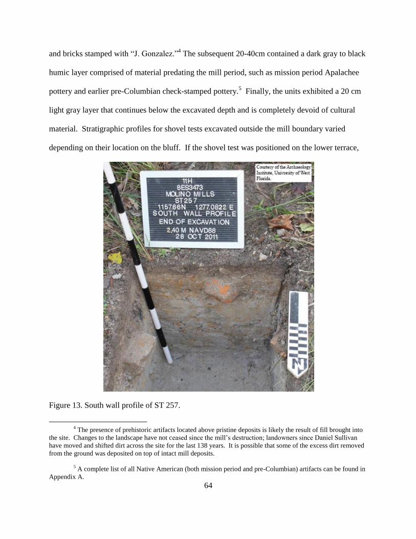
64
and bricks stamped with “J. Gonzalez.”4 The subsequent 20-40cm contained a dark gray to black
humic layer comprised of material predating the mill period, such as mission period Apalachee
pottery and earlier pre-Columbian check-stamped pottery.5 Finally, the units exhibited a 20 cm
light gray layer that continues below the excavated depth and is completely devoid of cultural
material. Stratigraphic profiles for shovel tests excavated outside the mill boundary varied
depending on their location on the bluff. If the shovel test was positioned on the lower terrace,
Figure 13. South wall profile of ST 257.
4 The presence of prehistoric artifacts located above pristine deposits is likely the result of fill brought into
the site. Changes to the landscape have not ceased since the mill’s destruction; landowners since Daniel Sullivan
have moved and shifted dirt across the site for the last 138 years. It is possible that some of the excess dirt removed
from the ground was deposited on top of intact mill deposits.
5 A complete list of all Native American (both mission period and pre-Columbian) artifacts can be found in
Appendix A.

65
then the typical profile was a mix of cultural material from all periods of occupation postdating
the mission period for 20-60cm, followed by a 20-30cm gray to black humic layer containing
exclusively Native American material dating from 1761 and earlier. Finally, these units ended
with 20cm of sterile soil (Figure 13). If the shovel test came from in the floodplain, the typical
profile consisted of exclusively mixed contents from all time periods intermixed with oscillating
layers of root-mat and alluvial sand (Figure 14). This profile is likely a result of numerous
flooding and drought episodes. During periods of drought, the forest undergrowth extended into
areas once inundated and, as river levels rose, the undergrowth was once again covered by water.
The river then deposited the observed alluvial sand over the now dead undergrowth.
Figure 14. North wall profile of ST 258.

66
An examination of soil profiles for completed shovel tests revealed a clear outline of the
mill. The mill extends approximately 30m x 60m (98.5ft x 197ft) angled northwest to southeast
(Figure 15). This angle matches with the 1877 sketch of Molino Mills located in William
Chipley’s Pensacola (the Naples of America) and its surroundings illustrated: New Orleans,
Mobile, and the resorts of the Gulf Coast.6 Additionally, these dimensions match with those
designated in an 1875 Florida Broadside for the main mill building of Molino Mills at 85ft x
205ft or 26m x 62.8m.7
Figure 15. Close-up aerial view of units targeting Molino Mills including the approximate mill
boundary. Boundary is defined by white line and terrace edges defined by blue lines.
6 Chipley, Pensacola (the Naples of America) and Its Surroundings Illustrated, 30.
7 Smith, Assignee's Sale in Bankruptcy, of Steam Saw Mill, Timber Lands, Stores, Houses and Furniture,
Logs, Steamer, Lighters and Booms, &c., Situated in Florida and Alabama, Florida Broadside Collection.
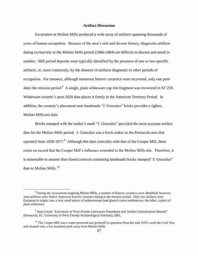
67
Artifact Discussion
Excavation at Molino Mills produced a wide array of artifacts spanning thousands of
years of human occupation. Because of the area’s rich and diverse history, diagnostic artifacts
dating exclusively to the Molino Mills period (1866-1884) are difficult to discern and small in
number. Mill period deposits were typically identified by the presence of one or two specific
artifacts, or, more commonly, by the absence of artifacts diagnostic to other periods of
occupation. For instance, although numerous historic ceramics were recovered, only one post-
dates the mission period.8 A single, plain whiteware cup rim fragment was recovered in ST 259.
Whiteware ceramic’s post-1820 date places it firmly in the American Territory Period. In
addition, the ceramic’s placement near handmade “J. Gonzalez” bricks provides a tighter,
Molino Mills-era date.
Bricks stamped with the maker’s mark “J. Gonzalez” provided the most accurate artifact
date for the Molino Mills period. J. Gonzalez was a brick maker in the Pensacola area that
operated from 1838-1877.9 Although this date coincides with that of the Cooper Mill, there
exists no record that the Cooper Mill’s influence extended to the Molino Mills site. Therefore, it
is reasonable to assume that closed contexts containing handmade bricks stamped “J. Gonzalez”
date to Molino Mills. 10
8 During the excavations targeting Molino Mills, a number of historic ceramics were identified; however,
most artifacts were Native American historic ceramics dating to the mission period. Only two artifacts were
European in origin: one, a very small pierce of indeterminate lead glazed coarse earthenware, the other, a piece of
plain whiteware.
9 Janet Lloyd, “University of West Florida Laboratory Procedures and Artifact Classification Manual”
(Pensacola, FL: University of West Florida Archaeological Institute), 2001.
10
The Cooper Mill was a water-powered saw/gristmill in operation from the mid 1830’s until the Civil War
and situated only a few hundred yards away from Molino Mills.

68
Figure 16. Plain whiteware cup rim found in level 21 (2.199mNAVD88-2.10mNAVD88) of ST
259.
One final diagnostic artifact relating to the Molino Mills period is the cut nail. Most cut
nails were in excellent condition, requiring very little conservation. Many were purple in color,
likely resulting from the mill’s destruction, which would have annealed the nails, promoting
preservation. All recovered cut nails appear to have a stamped head, which dates the nails to
after 1825 (cut nails were likely eclipsed by wire nails around 1900).11
Cut nails post-date the
mission period and are therefore identified with the Molino Mills Period. Additionally, cut nails
11
Eric Sloane, A Reverence for Wood (New York: Funk and Wagnalls, 1965), 25.

69
were often found in the same context as “J. Gonzalez” bricks, further reinforcing their
association with Molino Mills.
Figure 17. “J. Gonzalez” brick found at Molino Mills.
Features
Excavations encountered and recorded a number of features. The features were
designated numbers 300-311.12
Features 301-304 and 306-311 relate to Molino Mills, in
addition to a number of features relating to Molino Mills identified during the 2009-2012
12
Feature numbers 1-299 and 400-499 were reserved for excavations that occurred during the 2009-2012
Colonial Frontiers Fieldschool. Feature numbers 300-399 were reserved for features identified during the 11H
Molino Mills excavations.

70
Colonial Frontiers Fieldschools. Any identified features not related to the mill period, such as
features 300, 305 and 306, are not discussed in this paper.
Features (F.) 301, 307, and 311 are cut boards. F. 301 was located within ST 252 at a
depth of 4.799m NAVD88 and immediately adjacent to structure 2. The board has no
distinguishing characteristics and is approximately 20cm (7.9in) wide, 4cm (1.6in) thick, and
extends the entire length of the unit. Its proximity to structure 2 and F. 302 suggests that the cut
board is a structural element related to the structure 2’s foundation. F. 307 was located in ST
259 at a depth of 1.93mNAVD88, measures approximately 24cm (9.5in) wide and 4cm (1.6in)
thick, and extends the entire length of the unit. ST 259 was located in the floodplain just beyond
the drop off and contains one of two European historic ceramics located below the upper terrace
of Durants Bluff. Additionally, the unit consisted almost entirely of brick, none of which were
complete, suggesting that this location was a trash dump. Although not readily apparent, the cut
board was probably defective or broken and thus discarded. F. 311 was located in ST 261 at a
depth of 1.94m NAVD88, measures 24cm (9.5in) wide and 4cm (1.6in) thick, and extends the
entire length of the unit. ST 261 was, like shovel test 259, located in the floodplain and the unit
also appears to be a trash dump. Although no defects were observed, F. 311 was probably
discarded because of an imperfection.
F. 302 was located within the eastern wall of ST 252 and immediately adjacent to
structure 2. The feature is an intact wall structure composed of bricks that extends at least 30cm
from top to bottom. The final depth could not be ascertained because F. 301 inhibited further
excavation. The feature’s association with structure 2 indicates a subsurface structural
component.

71
As a result of F. 303’s complexity, it was separated into 5 sections, 303A-E. F. 303 was
located in ST 250, which is in-between the four granite blocks of structure 1. The feature began
at 5.11m NAVD88 and extended to a depth of 4.85m NAVD88.13
All five feature sections are
portions of burnt material consisting of either charred logs or a carbonized wood layer. F. 303A
and 303C are intact, burnt logs and were not excavated. F. 303B was a layer of carbonized wood
excavated and screened through 1/16” mesh. Broken bits of brick and granite were identified
within this layer. F. 303D and 303E were very fragile burnt timbers and, because of their
fragility, they were left unexcavated. This feature’s location and burnt composition makes it
likely that it is the remnant of a fire that heated up the mill’s boilers.14
F. 304 was encountered in ST 255 at a depth of 5.09m NAVD88. It was partially
excavated before being identified and was, therefore, approximately 10 cm in height ending at
5.04m NAVD88.15
The feature was composed of semi-compact sandy clay, linear in nature, and
extended across the entire unit. The presence of brick supports a mill period date. The feature is
possibly a clay floor associated with Molino Mills, but further investigation is necessary to
ascertain a more accurate conclusion.
F. 308 was located in ST 260 at a depth of 4.95m NAVD88. The feature consisted of an
extremely dense clay layer that became softer and more consistent with a sandy loam as
excavation progressed, ending at a depth of 4.65m NAVD88. The contents of the feature were
exclusively mill period artifacts, including brick, cut nails, iron, and coal. This unit was located
13
This unit was not excavated to sterile soil because the feature prevented further excavation.
14
For more detail, please see the section discussing structure 1 later in this chapter.
15
Its full height can be observed in the south wall profile of ST255.
72
within the mill boundary and is, therefore, probably a clay floor hardened during the mill’s
burning episode.
F. 309 was located in ST 262 and separated into two sections: 309A and 309B. Section
A consisted of a compact clay, while section B was a compact sandy loam. Section A was semi-
circular in shape and extended into the northwest corner of the unit. Section B was also semi-
circular in nature and existed just outside of section A. Neither section contained any cultural
material post-dating the mill period: section A was comprised mostly of brick and cut nails,
while section B contained brick, cut nail fragments, and a single Native American ceramic. The
unit’s location just outside the mill boundary, in addition to its bowl-like shape, insinuates that
this feature is likely a hearth.
F. 310 was located in ST 261, in the floodplain of Durants Bluff. The feature began at
2.22m NAVD88 and ended 22cm deeper. This feature was separated into 2 sections: section A
was a loose sandy loam, and section B was a semi-compact sandy loam. Both sections are half
circular in shape, with section B existing underneath section A. The feature is below a whiskey
bottle dating from 1935-1964 and above a mill period cut board (F. 311). The lack of diagnostic
artifacts from within this feature leaves a wide date range spanning 1866-1964. The shape and
contents do suggest, however, that F. 310 was a hearth feature.
In addition to the features excavated for the project, three features exist directly related to
Molino Mills (F. 131, 157, and 213) that were excavated as part of UWF’s Colonial Frontiers
Fieldschool. F. 131 was first identified in the summer of 2010, further excavated in 2011, and
reencountered in 2012. F. 131 is a brick-filled trench resting on the remnants of a wooden box
supported by iron nails. In 2010, F. 131 was identified in the 2m x 2m unit 1090N 1242E and
divided into four sections (A-D). Sections A and D are the same section: because of section D’s

73
post-like shape, it was separated from A, but later determined to be, in fact, the same section of
the same feature. Section A denotes the main, brick-filled trench, as well as the wooden box
with vertical nails located below the bricks, while sections B and C are the fill surrounding
section A. Section B was on the northwestern side of section A, while section C was located on
the southeastern side. Section A contained numerous hand-made bricks (identified as possible
ladrillos), mission period Native American pottery, seed beads, and iron nails. Section B
contained hand-made bricks, while section C contained no diagnostic artifacts. In 2011, F. 131
was identified in two units, 1090N 1242E and 1088.2N 1241.5E, and, in the latter, separated into
three sections: BA, BB, and BC.16
Excavation in 1090N 1242E was not completed in 2010 and
eventually excavated to sterile in 2011.
The unit 1088.2N 1241.5E was opened to target F. 131 in order to further investigate the
origins and characteristics of the feature. Unit 1088.2N 1241.5E was a 1m x 1.5m placed off
grid in order to observe the entire feature.17
Section BA is the brick portion of the trench, not
including the remnants of the wooden box and nails, which, in 2011, was designated section BB.
Section BC refers to the fill found around either side of section BA. Section BA contained bricks
stamped “J. Gonzalez.” Section BB contained Native American ceramics and iron nails, while
section BC contained brick fragments and iron nails. In 2012, F. 131 was encountered in the
wall of 1082N 1236.5E. The feature was only partially excavated before excavation ceased for
16
During the Colonial Frontiers Fieldschool, sections of the same feature are given extra letters to
designate years. For instance, in 2010, sections for given feature sections may have been designated A, B, C, etc.,
while, in 2011, the same feature (from the same or a different unit) would have sections designated BA, BB, BC,
etc., and, in 2012, sections would have been designated CA, CB, CC, etc., and so on. This does not preclude the
possibility that they correspond to the same section from the same unit, but rather designates which year the feature
was excavated. For instance, feature 131A and 131BA/131BB are the same portions of the same brick trench
feature, but were excavated in different years (and just happen to be from different units).
17
The unit walls for 1088.2N 1241.5E did not have N-S directionality. The walls maintained the same NE-
SW directionality as F. 131.

74
the summer; material excavated in 2012 is currently waiting for processing. The presence of
numerous bricks stamped with portions of the “J. Gonzalez” maker’s mark firmly dates this
feature to the Molino Mills period. The presence of earlier mission period ceramics are likely
the result of digging through mission period remains to construct the brick trench. F. 131 began
at F. 157/213. Probing revealed that it terminates at least 15m later, following a northeastern
heading. The feature heads directly from F. 157/213 toward structure 1. This feature is
interpreted as an aqueduct meant to transport water from 157/213 to structure 1.
F. 157 was first identified in 2010 in unit 1080N 1235E. F. 157 was approximately 74cm
x 50cm (29.1in x 19.7in) and contained Native American ceramics, majolica, and wrought nails.
Archaeologists during the 2010 Colonial Frontiers Fieldschool originally identified the feature as
a corner of F. 10.18
The presence of a tree fall obscured the feature’s true nature. During the
summer of 2011, the feature was better defined as excavation progressed, and it became clear
that F. 157 was a builder’s trench surrounding a well. Section A was therefore designated as the
internal well, while section B denoted the builder’s trench surrounding the well. The principal
investigator of the Colonial Frontiers Fieldschool redesignated the better-defined feature with a
new feature number, 213. F. 213, section A refers to the inside portion of the well, while
sections B and C refer to the builder’s trench surrounding the well. F. 213 contained whiteware,
a gunflint fragment, lead shot, and several types of Native American ceramics. Based on cultural
material present and the feature’s characteristics, the principal investigator determined the
feature to be an artesian well dating to the mill period.
18
Feature 10 has been interpreted as a stockade wall from Mission San Joseph de Escambe and, therefore,
will not be discussed in this thesis. More information on this feature or other mission components can be found in
Worth and Melcher, Annual Report 2009 Archaeological Evaluation Mission San Joseph de Escambe (8ES3473);
Worth, Harris, and Melcher, Annual Report 2010 Archaeological Evaluation Mission San Joseph de Escambe
(8ES3473).
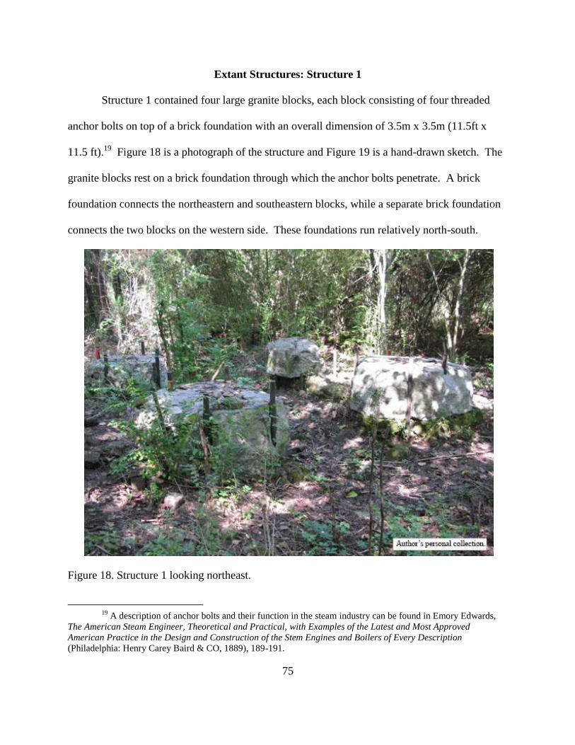
75
Extant Structures: Structure 1
Structure 1 contained four large granite blocks, each block consisting of four threaded
anchor bolts on top of a brick foundation with an overall dimension of 3.5m x 3.5m (11.5ft x
11.5 ft).19
Figure 18 is a photograph of the structure and Figure 19 is a hand-drawn sketch. The
granite blocks rest on a brick foundation through which the anchor bolts penetrate. A brick
foundation connects the northeastern and southeastern blocks, while a separate brick foundation
connects the two blocks on the western side. These foundations run relatively north-south.
Figure 18. Structure 1 looking northeast.
19
A description of anchor bolts and their function in the steam industry can be found in Emory Edwards,
The American Steam Engineer, Theoretical and Practical, with Examples of the Latest and Most Approved
American Practice in the Design and Construction of the Stem Engines and Boilers of Every Description
(Philadelphia: Henry Carey Baird & CO, 1889), 189-191.

76
There is a hole in the western side of the brick foundation beneath the northeastern granite block
that measures 17cm x 17cm (6.7in x 6.7in), as well as sister void in the foundation beneath on
the eastern side of the northwestern granite block. There are similar matching holes in the
foundations beneath the southwestern and southeastern granite blocks. A timber may have fit
into these holes and connected the blocks; these timbers would have created a sturdier foundation
for the structure. An unknown author wrote in Scientific American that “A brick foundation with
granite capstones with anchor bolts from the bottom is the best.”20
Figure 19. Hand drawn sketch looking down at structure 1.
20
“Notes & Queries,” Scientific American 48 (1883): 363.

77
As mentioned, the well, F. 157/213, appears to flow through the brick trench supported
by a wooden box (F. 131) directly toward structure 1. Additionally, the burned F. 301 was
excavated in the center of structure 1. The presence of these features in conjunction with the
massive size of the structure itself suggests that structure 1 is the location of one or more boilers
for the mill. The well (F. 157/213) and trench (F. 131) would have brought fresh spring water
into the boiler. Utilizing a well in combination with a trench to transport water was a common
practice in the area. The Escambia River is a freshwater river, but it contains many particulates
that, when boiled, would have limited the life of the boiler. The rapid boiling action would
rapidly move particulates around the inside of the boiler, slowly wearing away the boiler’s
integrity.
Structure 2
Structure 2 has a brick foundation with an overall dimension of approximately 2.5m x
1.1m (8.2ft x 3.6ft), with the 2.5m (8.2ft) side positioned almost perfectly north-south. The brick
foundation has a number of brick layers extending approximately 40cm (15.7in) above ground
surface. In the center of the structure, there is a void in the foundation measuring 45cm x 20cm
(17.7in x 7.9in) that extends to a depth of 85cm (33.5in). There are seven iron anchor bolts of
varying lengths, similar in diameter to those found in structure 1. Four of the anchor bolts have
been cut below the threading, while the three northernmost anchor bolts still display threading.
The bolts containing threading extend 85cm (33.5in), 83cm (32.7in), and 45cm (17.7) above the
brick surface. A portion of the subsurface brick foundation was exposed in ST 252 and
identified as F. 302. Although the feature was not completely exposed, the foundation extends at
least 60cmbs. The structure is substantial in size and extremely solid in construction; it is likely
that the structure is an anchor for some type of machinery. Historical documents describe a wide

78
array of machinery in operation at Molino Mills including “8 Boilers, 2 Engines, 2 Double
Circular Saws, 1 Gang, 2 Gang Edgers, Lath Machine, Cutting-off Saws, 2 Screw Cutting
Lathes, 1 Planer (iron), 1 Schenck Wood.”21
Based on the structure’s location, it is unlikely to
be connected to the boilers. Rather, its robust construction suggests it is associated with one of
the saws. Saw machinery requires a fairly substantial support structure to overcome the
vibrations generated by the saw itself. Lathes and planar machines are generally more forgiving
and require a smaller foundation, but their placement on structure 2 cannot be completely ruled
out.
Figure 20. Photograph of structure 2 looking north.
21
Smith, Assignee's Sale in Bankruptcy, of Steam Saw Mill, Timber Lands, Stores, Houses and Furniture,
Logs, Steamer, Lighters and Booms, &c., Situated in Florida and Alabama, Florida Broadside Collection.

79
Structure 3
Structure 3 is not so much a structure as it is a series of seven exposed metal bolts located
7.5m (24.6ft) north of structure 2 and positioned in two rectangles. One of the rectangles is
missing a fourth corner; however, the missing bolt is likely buried beneath a small mound that is
located in its approximate position. Among the seven bolts there are three styles. The first style,
designated style A, consists of four bolts containing a rectangular hole with all four bolts
positioned in the same rectangle. The partial rectangle containing the other two styles is 1.9m
(6.2ft) east-northeast of the complete rectangle containing the first style. In the partial rectangle,
the northeastern bolt is missing. The two southern bolts are anchor bolts consisting of threaded
caps and are designated style B. These anchor bolts are similar to the anchor bolts found in
structures 2 and 3. The northwestern bolts are anchor bolts like those of style B, but also have a
nut and two round cap washers attached. These bolts were designated style C. The round cap
washers distributed the force of the machinery across a now deteriorated foundation. The bolt
feature likely represents the location of a machinery anchor.22
Style A contains a hole suitable
for the connection via a drive pin that could be easily driven in and out.23
Structure 3 would
have supported a smaller piece of machinery, like a lathe, or was possibly used in conjunction
with another, yet unidentified, structure to support a larger piece of equipment. Time constraints
prevented any excavation to investigate the subsurface portions of the bolts.
22 Anchor bolts nearly identical in shape and size to the style C bolts are found in the building that houses
the Florida Public Archaeology Network’s Destination Archaeology Resource Center, located in downtown
Pensacola. The Florida Public Archaeology Network building was originally constructed in 1903 as a depot for the
Louisville and Nashville Railroad.
23
These pins or bolts were likely similar to drift bolts or clench bolts as described in Michael McCarthy,
Ships’ Fastenings from Sewn Boat to Steamship (College Station: Texas A&M University Press, 2005), 180-181.

80
Figure 21. Photographs of structure 3. Styles A, B, and C are left to right.
Figure 22. Scale drawing of structure 3 demonstrating the relative locations of the bolts.

81
Maritime Fieldwork Results
One method utilized to determine the relationship between Molino Mills and the
Escambia River involved maritime fieldwork to determine if any extant submerged remains
relating to Molino Mills exist. An examination of these submerged remains, in conjunction with
historical documents, helped determine the nature of the aforementioned relationship. Low
water levels experienced during the summer of 2011 exposed a number of previously unknown
features, which aided in the discovery and documentation of remains located in the Escambia
River.
One of these features was designated as a trench, extending approximately 5m (16.4ft)
out of the river bank (Figure 23). Its construction can be likened to a ship, which contains outer
hull planking attached to frames with the equivalent of ceiling planking on the innermost portion.
The trench is 1.1m (3.6ft) wide with a depth (the distance between the top of the wood to the
bottom of the trench) of approximately 50cm (1.6ft). It is angled about 30° west of north. No
excavation took place to further investigate the trench itself, but a number of other wooden
features resembling the trench were identified throughout the floodplain. These trenches appear
to be related and form a discernible path through the landscape. The trench is most likely a
portion of a log canal which transported logs from the river into the mill and potentially further
downstream toward Pensacola Bay. Additionally, canal remnants appear to cut through the
oxbow bend located next to Molino Mills. An oxbow bend creates a hazard when large
quantities of logs are floated downriver. The bend can create a bottleneck which increases the
likelihood of a log jam. This oxbow cut would have allowed logs to be transported directly from
the mill to the wharf or landing. The logs were then tied into rafts and sent downriver to
Pensacola Bay.
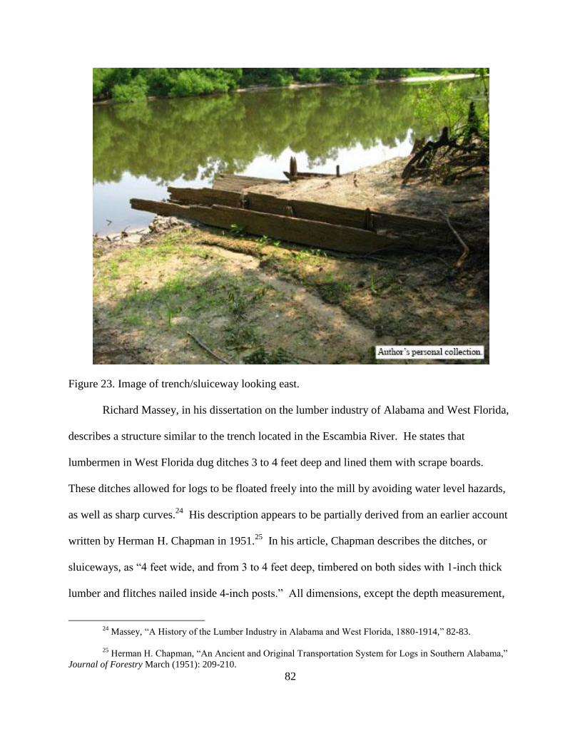
82
Figure 23. Image of trench/sluiceway looking east.
Richard Massey, in his dissertation on the lumber industry of Alabama and West Florida,
describes a structure similar to the trench located in the Escambia River. He states that
lumbermen in West Florida dug ditches 3 to 4 feet deep and lined them with scrape boards.
These ditches allowed for logs to be floated freely into the mill by avoiding water level hazards,
as well as sharp curves.24
His description appears to be partially derived from an earlier account
written by Herman H. Chapman in 1951.25
In his article, Chapman describes the ditches, or
sluiceways, as “4 feet wide, and from 3 to 4 feet deep, timbered on both sides with 1-inch thick
lumber and flitches nailed inside 4-inch posts.” All dimensions, except the depth measurement,
24
Massey, “A History of the Lumber Industry in Alabama and West Florida, 1880-1914,” 82-83.
25
Herman H. Chapman, “An Ancient and Original Transportation System for Logs in Southern Alabama,”
Journal of Forestry March (1951): 209-210.
83
are identical to those found on the trench located in Molino.26
Chapman continues by explaining
the process through which a dam is raised and water flows into the trench, thereby floating logs
along the trench into the mill. This process provided an efficient and cost-effective method of
short-distance log transportation. Chapman describes the earliest recorded instance of log
transportation via a trench or sluiceway conducted by Major William Wallace, who, in 1874,
“used to float logs to his mill near Molino, Florida.”27
William Wallace is listed in the 1880 U.S.
Census as living in precinct 9. According to this census, precinct 9 is Bluff Springs, Florida.
Bluff Springs is approximately 15 miles north of Molino on the Escambia River.28
As a result of low water levels in the summer of 2011, a number of pilings were also
observable just below the Escambia River’s surface. This observation prompted a pedestrian
survey of the Escambia River, conducted by students from the 2011 Combined Maritime and
Terrestrial Fieldschool. The survey revealed a total of 32 pilings, 16 of which ran in a straight
line in the middle of the river. The line extends approximately 64m (210ft) in a
northwest/southeast direction, terminating at a pier structure (MMM20 and MMM21). The
pilings are rectangular or circular in shape and there appears to be no pattern in piling location
based on shape or size. Massey describes a similar structure and how it was utilized:
As they [logs] came down the river, the various mills located on the river would
collect their own. This was done by driving pilings in the middle of the river
about a half mile above the mill. A swinging boom from the bank could be
attached to the piling, thus completely blocking off the river and stopping all logs.
As the logs came down, a man would jump on them, turn them over, if necessary,
26
This does not preclude the possibility that what remains of the trench found in Molino is only a portion of
a complete trench, where a portion of the trench has not survived to the present day.
27
Massey, “A History of the Lumber Industry in Alabama and West Florida, 1880-1914,” 83.
28
U.S. Bureau of the Census, Population Schedules of the Tenth Census of the United States, Washington
DC, National Archives Microfilm Publications, Micro-copy no. T-9, Florida, Election Precincts 7-9, 14, University
of West Florida Library Special Collections, Pensacola, FL.

84
to see the brand, and then either let them continue down the river of place them
over against the pilings.29
Records that list “boom tender” as an occupation, including the 1870 and 1880 U.S. censuses,
indicate that a boom was used in Molino. 30
Figure 24. Aerial view of Molino displaying contoured data from the magnetometer survey area.
29
Massey, “A History of the Lumber Industry in Alabama and West Florida, 1880-1914,” 82-82.
30
U.S. Bureau of the Census, Population Schedules of the Ninth Census of the United States, Washington
DC, National Archives Microfilm Publications, Micro-copy no. 593, Florida, Molino Election Precincts, 155,
University of West Florida Library Special Collections, Pensacola, FL; U.S. Bureau of the Census, Population
Schedules of the Tenth Census of the United States, 27.

85
Figure 25. Colored contoured survey data. Purple represents the highest recorded nT readings,
while green signifies the ambient magnetic field.
In addition to a pedestrian survey, students conducted a magnetometer survey of the
Escambia River. Contouring of the recovered data resulted in the identification of 21 targets
with a magnitude greater than 15nT (nanotesla), the highest of which was 753nT. These targets
were designated MMM (Molino Mills Magnetometer) 1-21. Most of the targets could be
associated with structures visible on the landscape, such as a railing at the county fairground/boat
ramp, Mr. Richard Marlow’s steel dock, a floating dock, or a beached boat (Figure 25). Two

86
targets, MMM20 and MMM21, could not be associated with any known structure and warranted
further investigation.
Figure 26. Hand drawn sketch of MMM20 and MMM21.
MMM20 and MMM21 had a magnitude of 202nT and 329nT respectively. A circle
search revealed the remains of a collapsed dock structure (Figure 26). The structure runs in
succession with the line of 16 pilings. The area demarcated by the pilings and structure is likely
the southern end of a holding pen for logs destined to be processed. The wall measures
approximately 11.7m (38.4ft) long and is angled almost perfectly north; it then takes a
southeastern turn in line with the directionality of the 16 piling row. A portion of the decking
has broken off and rests just east of the walled portion. The walled portion consisted of long cut

87
boards stacked side by side and held together with large iron spikes that continue into the
sediment.
The information laid out in this chapter represents the work of over 30 UWF students and
faculty members taking place over a 14-month period between February 2011 and April 2012.
The analysis, discussion, and conclusion resulting from this fieldwork are discussed in the
following chapter.

88
CHAPTER VI
CONCLUSION
The investigation into Molino Mills began as a class project, when the extant remains
located adjacent to Mission San Joseph de Escambe were then unidentified. The class project
entailed combing through numerous archives to pinpoint the mill’s identity. Four possibilities
for the mill’s identity were uncovered: the Cooper Mill, Molino Mills, the Molino Lumber and
Brick Company, and the Jacobi Lumber Company. The only mill which corresponded with a
mission location, however, was that of Molino Mills. With its identity confirmed, the class
project evolved into a thesis. This thesis entailed extensive archival research into a poorly
documented era, terrestrial excavations that revealed a material assemblage consistent with a
Reconstruction Era mill, and a riverine survey that determined if any submerged mill remains
survived the last 130 years. The research design established three distinct goals: to determine the
mill’s boundary and document extant remains, to define the relationship between Molino Mills
and the Escambia River, and, finally, to ascertain the importance of Molino Mills in the West
Florida lumber industry.
Determining the extent of the mill’s footprint by identifying its boundaries at first
appeared to be a minor goal, but, upon a closer inspection of documentary evidence, defining the
boundary became a rather important one. Early in the investigation, the only available
documentary evidence that described the mill was a sketch found in William Dudley Chipley’s
Pensacola (the Naples of America) and its Surroundings Illustrated: New Orleans, Mobile, and
the Resorts of the Gulf Coast.1 The sketch depicts the mill from a vantage point across the river,
looking north. It illustrates the main mill building with accompanying smokestack, lumber
1 Chipley, Pensacola (the Naples of America) and Its Surroundings Illustrated, 30. A copy of this image
can be found in Chapter III (Figure 6).

89
drying racks, wharf structure, log rafts, and two vessels. As such, a shovel test survey was the
most appropriate method to uncover the location of the mill and its extents. The resulting
terrestrial survey provided evidence to support a mill 30m x 60m (98.5ft x 197ft) in dimension,
which closely coincided with dimensions from historical documents.
Shortly following the shovel test survey’s completion, a new document came to light that
described not only the relationship between Molino Mills and the Pensacola Lumber Company,
but also provided an inventory of company assets. The document was a broadside detailing the
Pensacola Lumber Company’s sale at public auction in New York City.2 The broadside lists
numerous buildings for sale, including “One large Steam Saw Mill; 28 Dwelling Houses, and
Furniture in Manager’s house; 1 Store, Blacksmith and Carpenter Shop and Tools; Wharf and
Landing; …1 Grist Mill.”3 This list includes only buildings that are within the community of
Molino, and do not include those outside Molino, such as a store in Whiting, Alabama.
Numerous trips to the Escambia County’s Clerk of Court Archives failed to divulge the location
of these additional structures. Therefore, while the project was successful in identifying the main
sawmill’s position, it failed to identify the location of the additional 30 known structures.
Further archival research may pinpoint a general location of these buildings, and, when followed
by additional shovel testing, could uncover the structures’ exact positions.
A riverine survey aided in determining the relationship between Molino Mills and the
Escambia River. Upon completion of the survey, few documents had been located that described
the Molino waterfront. Two deeds records indicate that river landings once existed on Durants
2 Smith, Assignee's Sale in Bankruptcy, of Steam Saw Mill, Timber Lands, Stores, Houses and Furniture,
Logs, Steamer, Lighters and Booms, &c., Situated in Florida and Alabama, Florida Broadside Collection.
3 Ibid.

90
Bluff.4 Neither record, however, provided any details concerning layout or size. A layout first
appears in Chipley’s 1877 mill image.5 The image depicts a massive wharf structure, including a
boat house, log rafts, a vessel (possibly a tug), and a barge. Based on the image’s directionality,
extant pilings related to the wharf structure have survived in the Escambia River. The river
conditions were not conducive to a pedestrian survey of this area; therefore, a portion of the river
north of the mill was surveyed.
The riverine survey revealed several structures relating to the Reconstruction Era. These
included a trench or sluiceway in an excellent state of preservation, as well as remains of 32
pilings (16 of which ran in a straight line) and a collapsed dock. Drawings of all the
aforementioned features were recorded. From this scant amount of evidence, it appears that the
mill did, in fact, utilize the river, but archaeological evidence did not reveal to what degree the
mill utilized the river. A major hindrance was that Daniel Sullivan owned a railroad with
connections through Molino that had an extension running into Molino Mills.6 During a
conversation with Dr. John Worth, he revealed that the Colonial Frontiers Fieldschool exposed
archaeological evidence for a railroad bed, but the extents of the bed have yet to be determined.
Daniel Sullivan’s railroad interests and the archaeological evidence do suggest a reliance on
transportation via rail over transportation via the river; however, several documents, recently
uncovered, severely altered this assumption.
4 Escambia County, Deed Book B, 525-526, Escambia County, Deed Book P, 581-585.
5 Chipley, Pensacola (the Naples of America) and Its Surroundings Illustrated, 30.
6 Daniel Sullivan owned Molino Mills from 1878 until the mill’s destruction in 1884.

91
The first document was a Florida broadside advertising the sale of the Pensacola Lumber
Company.7 This document lists riverine structures such as “Wharf and Landing” and “between
30 and 40 thousand Pine Logs, in the stream, together with the Booms.”8 In addition, the
company maintained river-going vessels listed as “One Large Stern-Wheel Steamer” and “7
Skiffs; 1 Yawl Boat.” This document indicates the river’s importance to the mill and elucidates
that the mill did use a boom and wharf structure for floating logs into the mill. The document
also states that Molino Mills is located “on the line of the Pensacola & Louisville Railroad,
whose tracks run into the Mill Yard.”9 This statement insinuates that the railroad was the
primary mode of transporting lumber; however, other documents found in the Dana Sargent
papers suggest otherwise by describing the riverine and maritime influences on Molino Mills.
Dana Sargent owned, along with a few others, a stake in Molino Mills from 1876 until
1881. The collection contains approximately 70 pages of documents and provides, as of yet, the
only known shipping records and personal letters relating to Molino Mills.10
These documents
detail the use of the Escambia River and contain the most comprehensive source of information
pertaining to riverine use by Molino Mills. In a letter from Ale Conn to Dana Sargent, Mr. Conn
asked for permission to break up a raft and re-raft the longest timber before sending the rafts
7 Smith, Assignee's Sale in Bankruptcy, of Steam Saw Mill, Timber Lands, Stores, Houses and Furniture,
Logs, Steamer, Lighters and Booms, &c., Situated in Florida and Alabama, Florida Broadside Collection.
8 Ibid.
9 Ibid.
10
The Dana Sargent Papers are located at the P.K. Yonge Library at the University of Florida in
Gainesville, Florida.

92
down river.11
The letter provides one of the only definitive descriptions of rafting procedure at
Molino Mills. In a letter from W.D. Chipley to Dana Sargent, Chipley expresses that Molino
Mills utilized the river for the bulk of their log transportation needs. Furthermore, the mill used
rail only when they could not fill an order through riverine transportation. Chipley adds that the
lumber industry was depressed and that it would be cheaper to ship timber via water, as opposed
to rail.12
Moreover, Chipley appeared angered by Joseph Vaughn’s attempts to steal business
from his railroad by undercutting shipping prices, and stated that Chipley was very interested in
obtaining the mill’s business.13
Two weeks later, Chipley sent another letter to Sargent, this time
making a business proposition. The proposition involved Chipley shipping “all except square
sawn stuff 6 X 6 & upwards.”14
If Sargent agreed to the business proposition, Chipley would
“replace track at once & will give… prompt and faithful service.” Additionally, if given twenty-
four hours’ notice, Chipley offered to pay all fees due to “failure of service.”15
Unfortunately,
this is last known letter between the two individuals; it is not known if Sargent agreed to the deal
or continued to use rail transportation as a secondary means.
In addition to river rafting, the Dana Sargent papers provide evidence for oceangoing
shipping. A wide array of documents including personal letters, broker contracts, cargo lists, and
11
Based on the letters in the Dana Sargent Papers, Ale Conn is likely the superintendent of Molino Mills.
Ale Conn to Dana Sargent November 28, 1876, Dana Sargent Papers, P.K. Yonge Library, University of Florida,
Gainesville, Florida.
12
W.D. Chipley was a railroad tycoon who built two railroads in the Florida panhandle and even served a
term as Pensacola’s mayor. W.D. Chipley to Dana Sargent August 14, 1877, Dana Sargent Papers, P.K. Yonge
Library, University of Florida, Gainesville, Florida.
13
Joseph Vaughn was a boom tender, according to U.S. census records, and likely managed or at least had
many contacts involving riverine shipping. The document insinuates that Vaughn oversaw timber transportation via
the river; therefore, Vaughn was undercutting Chipley by charging cheaper fees for transporting logs.
14
W.D. Chipley to Dana Sargent August 27, 1877, Dana Sargent Papers, P.K. Yonge Library, University of
Florida, Gainesville, Florida.
15
Ibid.

93
schooner schedules suggest shipments that involved at least fifteen different vessels. Timber was
loaded onto both schooners and barks and subsequently transported numerous places, including
Boston, Philadelphia, New York, and Melbourne, Australia.16
Finally, Dana Sargent, in 1876, mentioned that Molino Mills received the tug Water
Witch. The Water Witch was worth approximately $2,737.00.17
Additionally, on June 16, 1877,
a survey of the river indicated that Molino Mills had about 128,000 ft2 of timber in the Escambia
River.18
It would be impossible to quantify the relationship between Molino Mills and the
Escambia River, yet some final conclusions can be deduced. First, based on a few documents
and extant remains, it is apparent that, throughout the mill’s operation, large quantities of logs
were floated into the mill from timber grounds north of the mill. A newspaper article from 1868
describes a log jam caused by Molino Mills: “We are told that the Conecuh and Escambia River,
for a distance of 200 miles, are literally jammed with saw logs, belonging to the Pensacola
Lumber Company, and destined for Molino. Experienced log men estimate their number at not
less than 40,000, or about 9,000,000 feet.”19
No records indicate that felled trees were shipped
by rail or by any other means from timber grounds into Molino Mills. Secondly, records specify
that, at least for a significant portion of the mill’s existence, the river acted as the main
thoroughfare for timber transportation along the Escambia River (at least prior to August 1877).
16
Shipping records and cargo lists found in Dana Sargent Papers, P.K. Yonge Library, University of
Florida, Gainesville, Florida.
17
Dana Sargent note, March 6, 1877, Dana Sargent Papers, P.K. Yonge Library, University of Florida,
Gainesville, Florida.
18
Specification of old timber in River, June 16, 1877, Dana Sargent Papers, P.K. Yonge Library,
University of Florida, Gainesville, Florida.
19
“200 Miles of Logs,” The Daily Phoenix, August 25, 1868.

94
Whether this trend continued following Dana Sargent’s tenure as a part owner of the mill
remains unknown. It is likely that, when Daniel Sullivan purchased Molino Mills, he utilized rail
transportation over river (considering he also owned the railway), although no documents
conclusively indicate either way. Finally, the records reveal that timber processed in Molino
Mills was shipped via oceangoing ships to the northeastern United States. No documents
describe timber shipped via rail to the northeast, even though railway connections did exist,
suggesting a reliance on the water over rail transportation.
Additionally, the riverine survey, as well as terrestrial fieldwork, aided to uncover how
Molino Mills and the town of Molino interacted within and upon the maritime landscape. In this
case, the landscape or locale analyzed is Durants Bluff, with Hoyt, Knight, and Ayer selecting
this landform because of its inherent features conducive to a sawmill operation. Durants Bluff
consists of an elevated area that exists immediately adjacent to the river. This elevation allowed
for the mill erected to reside close to the water, yet out of danger from annual water level rises.
The close proximity to the river decreased the distance necessary to transport logs from the river
into the mill. Still, for the mill owners, this close proximity was not small enough, and the
owners or mill manager commissioned the creation of a water-filled trench that allowed for logs
to be floated through the flood plain to a point immediately adjacent to the mill building. The
creation of a trench increased the workers' reliance on the maritime or, in this case, riverine
environment and thus expanded the riverine influence on the mill's culture. Furthermore, an
increased riverine space necessitated the mill manager to hire more raftsmen or individuals to
control the logs while in the trench. A similar increase arose from the mill manager’s erection of
the boom and piling structure, identified during the remote sensing survey and subsequent target
diving on MMM 20 and 21. This structure modified the riverine environment and increased the

95
mill’s reliance on the environment, and thus the maritime influence on the culture, while also
likely increasing profits.
The mill’s location at that point along the Escambia River, in conjunction with the
erection of numerous structures in and on the riverine landscape, transformed that landscape into
a transit point. A transit point exists at “connections with waterways inland and points where
vessel or transportation methods change.”20
Although the area of Durants Bluff, under this
definition, was not a transit point prior to the erection of Molino Mills, it certainly was during its
operation. At the mill, a mecca for riverine activity occurred in which transportation methods
changed from riverine to possibly rail, or continued, albeit in a different form, in the river. A
great deal of documentary evidence exists, such as the census records or the Dana Sargent
papers, that describes logs being floated into the mill or logs and processed timber floated to
Pensacola Bay for subsequent worldwide distribution. In fact, recall that Dana Sargent chose to
become more dependent on Joseph Vaughn and his riverine transport, as opposed to William
Chipley and his rail transport. This may have been for a purely economic reason; however, it
also demonstrates the connection between Molino Mills and the river, thus displaying the
societal maritime influences. Without Molino Mills and the modifications of the riverine
landscape, this area may have remained just another bend in the river instead of an important
economic zone.
The final goal for this project was also difficult to discern and nearly impossible to
quantify. Studies into West Florida’s lumber industry have typically focused on either
antebellum water-powered sawmills or turn-of-the-twentieth-century mill company towns,
leaving a large gap in the history of West Florida’s lumber industry lasting from 1865 until
20
Westerdahl, “The Maritime Cultural Landscape,” 6-7.

96
approximately 1885. Unfortunately, it is exactly during this timeframe when Molino Mills
operated. Although difficult, it is still possible to glean an idea of Molino Mills’ importance to
the industry. One way to establish significance is to examine the value of the mill to the
community of Molino. According to most documents, Molino Mills employed somewhere
between 125-200 men, although a secondary source places this number at 400 employees.21
U.S.
census records indicate that Molino had a population of 260 in 1870 and approximately 310 in
1880.22
An 1869 note written by J.J. Maguire and Thomas Paine places this number closer to
400.23
Depending on the source utilized, the mill employed some 30-100% of the community’s
inhabitants. In addition, most of the other residents of Molino may have been employed in
supporting roles, such as post office employees, grocers, etc. Such numbers attest to the
economic importance, at least locally, of Molino Mills.
Arguably, one of the best methods of examining Molino Mills’ place in the industry
would be to scrutinize the mill’s total output and to determine the proportion of West Florida’s
total lumber output. Unfortunately, in December of 1880, a fire destroyed approximately five
blocks of downtown Pensacola, including the U.S. Customs House, the Escambia County Tax
Collectors Office, and the Pensacola Gazette offices. Shipping records would have been held at
these locations, or possibly at the mill itself. As a result, very few shipping records exist from
the Reconstruction Era. Extant sources have estimated Molino Mills’ annual output at between
21
Armstrong, History of Escambia County, Florida, 116; J.H. Daffin, “The Story of the Town of Molino,
Florida,” The Molino Advertiser, March 26, 1915; Brackett, ““The Naples of America,” Pensacola During the Civil
War and Reconstruction,” 58.
22
U.S. Bureau of the Census, Population Schedules of the Ninth Census of the United States; U.S. Bureau
of the Census, Population Schedules of the Tenth Census of the United States.
23
J.J. Maguire and Thomas A. Paine to Harrison Reed, 12 July 1869, Governor Harrison Reed Papers.

97
18 and 32 million board feet.24
Documents from the Dana Sargent papers state that, in 1876,
approximately 500,000 board feet were shipped, and, in 1877, the mill shipped 1.5 million board
feet, while an additional 314,000 board feet could not be attributed to a specific year.25
Little data exists concerning West Florida lumber industry’s timber output; therefore, a
comparison with the scant data on Molino Mills’ lumber output is difficult to formulate. Richard
Massey states that, in 1883, Pensacola’s total lumber export was 102,370,000 feet of lumber;
Molino Mills would therefore account for 18-32% of the area’s total annual export.26
According
to John Brackett, a mill operating in Millview, Florida, had a daily output of 35,000 board feet in
1868.27
Brackett estimates Pensacola Lumber Company’s (Molino Mills) daily output at 60,000
board feet, almost double that of Millview’s output.28
Another source indicates that, in 1885, a
large mill in north Florida produced 10 million board feet annually.29
All sources suggest that, in
terms of production, Molino Mills was one of the largest mills in West Florida.
Another possible method to determine the importance of Molino Mills is to examine the
size of the mill itself. Descriptions regarding Molino Mills’ size include one noting that the
24
Armstrong, History of Escambia County, Florida, 116; J.H. Daffin, “The Story of the Town of Molino,
Florida,” The Molino Advertiser, March 26, 1915.
25
Dana Sargent Papers, P.K. Yonge Library, University of Florida, Gainesville, FL.
26
Massey, “A History of the Lumber Industry in Alabama and West Florida, 1880-1914,” 89; Drobney,
Lumbermen and Log Sawyers Life, Labor and Culture in the North Florida Timber Industry, 1830-1930, 32.
27
Millview is located on the Perdido Bay, about 8 miles west of Pensacola. By1868, the Pensacola and
Perdido railway was completed, connecting Millview with Pensacola, and allowing for rail transportation of timber
from Millview to the Port of Pensacola.
28
Brackett, ““The Naples of America,” Pensacola During the Civil War and Reconstruction,” 58-59.
29
Drobney, Lumbermen and Log Sawyers Life, Labor and Culture in the North Florida Timber Industry,
1830-1930, 30.
98
“largest producer of freshly cut timber in 1868 was the Pensacola Lumber Company.”30
Another
source calls the mill “one of the largest sawmills in the south.”31
An 1880s estimate states that a
mill needed a capital outlay of $60,000.00 and working capital between $25,000.00 and
$40,000.00.32
One estimate states that Molino Mills was erected at a cost of $200,000.00.33
In
addition, when the mill burned in 1884, it was an $180,000.00 loss.34
In other words, in 1866,
Molino Mills had a capital outlay over three times more than was necessary, insinuating that the
mill was very large.
Jeffrey Drobney states that, shortly following the Civil War, the largest mill in the
Blackwater Bay was located at Bagdad and was owned by the Simpson & Company Lumber
Company. The aforementioned Bagdad Mill produced about 30 million board feet annually.35
Additionally, he describes the largest mill in the Millview area as the Perdido Mill at 175ft x 55ft
and containing a single engine, one gang saw, two circular saws, and six boilers, with a 10-hour
output of 150,000 board feet.36
Molino Mills was documented with a size of 85ft x 206ft and,
based on the archaeological investigation, measures approximately 98.5ft x 197ft.37
Also, the
30
Drobney, Lumbermen and Log Sawyers Life, Labor and Culture in the North Florida Timber Industry,
1830-1930, 58.
31
J.H. Daffin, “The Story of the Town of Molino, Florida,” The Molino Advertiser, March 26, 1915.
32
Massey, “A History of the Lumber Industry in Alabama and West Florida, 1880-1914,” 170.
33
Hotchkiss, Industrial Chicago The Lumber Interest, 474.
34
“Molino Mills Burned,” The Pensacolian, September 13, 1884.
35
Drobney, Lumbermen and Log Sawyers Life, Labor and Culture in the North Florida Timber Industry,
1830-1930, 29-30.
36
Jeffrey Drobney states that, in 1880, the annual output for all mills in Millview (including the Perdido
mill and Abercrombie mill) was 30-40 million board feet. Ibid., 29-30.
37
Smith, Assignee's Sale in Bankruptcy, of Steam Saw Mill, Timber Lands, Stores, Houses and Furniture,
Logs, Steamer, Lighters and Booms, &c., Situated in Florida and Alabama, Florida Broadside Collection.

99
mill contained two engines, two double circular saws, one gang, two gang edgers, and eight
boilers.38
If the broadside listing Molino Mills’ characteristics is correct, that would make
Molino Mills the largest sawmill in Northwest Florida during the Reconstruction Era.
Based on size and production estimates, Molino Mills was likely a major player, if not
the major player, in the West Florida lumber industry during the Reconstruction Era. Based on
available documents, Molino Mills’ annual lumber output was one of, if not the largest in West
Florida. Finally, the mill was likely the lynchpin for the community of Molino. A significant
portion of the community would have worked in the mill itself, and another large portion of the
population would likely have worked in occupations that supported either the mill or mill
employees.
While records indicate that Molino Mills played a central role in the West Florida lumber
industry, they do not demonstrate the importance of this study. The mill operated in a difficult
time during reconstruction following the Civil War. It also acted as a prime example of a
transitional sawmill for both the national lumber industry and the lumber industry of Florida. In
regard to the national lumber industry, the industry saw a shift from northeastern and midwestern
forests to southeastern timber lands in the mid-1800s. By 1870, northern timberlands were
completely depleted and a new source of timber was in desperate need. During the late 1800s,
the completion of numerous railroads crisscrossing the South aided in the development of
extremely large sawmill complexes. Molino Mills fits perfectly within this general trend and
exemplifies a transitional mill that was one of the early, large southern sawmills operating before
and shortly after the railroads were completed. Molino Mills’ transitional nature and importance
can also be observed when examining the West Florida lumber industry.
38
Ibid.

100
West Florida prior to the Civil War was typified by small-scale, locally-used timber,
hewn and processed at water-powered mills.39
Following the Civil War, larger steam-powered
mills, such as Molino Mills, were commonplace. At first, these mills utilized riverine
transportation, but, as railroads began to open up virgin timberlands, these mills transformed into
the giant mills typically seen at the beginning of the twentieth century. These early, twentieth-
century mills were company towns and, for all intents and purposes, their own fully independent
communities. Molino Mills likely played a major role in the community of Molino’s prosperity.
A small community existed prior to Molino Mills, but it was not until the community took the
name “Molino” following the erection of Molino Mills that the community prospered.
Additionally, it is possible that Molino Mills represents a precursor to large mill company towns.
Molino was prospering and growing quickly during the time the mill operated. In fact, all
documentary evidence suggests that the town of Molino was named after the mill itself.
Furthermore, during the Reconstruction Era, Molino appears to have no other industrial
development, nor large, job-creating facilities, outside those dedicated to supporting the sawmill
industry. It is impossible to know if, had Molino Mills not burned, the community of Molino
would have turned into a company town. Based on documentary evidence, however, it appears
Molino may have been headed in that direction.
Most studies have focused on what some may deem “glamorous” mill sites, such as early,
often family-run, water powered mills or the easily identifiable large scale company town mills,
leaving a large void in the scientific community’s understanding of West Florida’s lumber
industry. Unfortunately, vast collections containing documents relating to Reconstruction Era
mills in West Florida simply do not exist, but, with a little patience and diligence, a clearer
39
There are some exceptions, such as the larger, water-powered mills in Bagdad and a few early, steam-
powered sawmills.

101
picture of these mills can be obtained. Additionally, archaeological investigations into these
mills reveal little documented and poorly understood aspects of the lumber industry, like log
rafting and riverine resources. This study has attempted to elucidate one particular sawmill,
Molino Mills, demonstrate its significance in West Florida’s lumber industry during the
Reconstruction Era, and reveal the possibility of its role in the evolution of the development of
the milling industry from small, water powered mills to steam powered sawmills, precursors to
the large mill company towns. If nothing else, this study has demonstrated that these sawmills
are significant and worthy of future investigation.
102
REFERENCES
“200 Miles of Logs.” The Daily Phoenix, August 25, 1868.
Aberg, Alan, and Carenza Lewis, eds. The Rising Tide: Archaeology and Coastal Landscapes.
Oxford, UK: Oxbow Books, 2000.
Allen, I. E. “Noted Escambia County Families: Cooper Family and Dr. Parker.” The Pensacola
Journal, February 10, 1907.
Armstrong, Henry C. History of Escambia County, Florida. St. Augustine, FL: The Record
Company, 1930.
Ash, Aiden. The Maritime Cultural Landscape of Port Willunga, South Australia. Flinders
University Maritime Archaeology Monographs Series, no. 4, Adelaide: Shannon
Research Press, 2007.
Babcock & Wilcox Company. Steam: Its Generation and Use With the Catalogue of the
Manufactures of the Babcock & Wilcox Co. London: Babcock and Wilcox Company,
1896.
Balée, William. “Historical Ecology: Premises and Postulates.” In Advances in Historical
Ecology, edited by William Balée, 13-29. New York: Columbia University Press, 1998.
_____. “Introduction.” In Advances in Historical Ecology, edited by William Balée, 1-12. New
York: Columbia University Press, 1998.
Ballard, Chris, Richard Bradley, Lise Nordenborg Myhre, and Meredith Wilson. “The Ship as
Symbol in the Prehistory of Scandinavia and Southeast Asia.” World Archaeology 35, no.
3 (2003): 385-403.
Bannerman, Nigel and Cecil Jones. “Fish-trap Types: a Component of the Maritime Cultural
Landscape.” The International Journal of Nautical Archaeology 28, no. 1 (1999): 70-84.
Barber, Ian. “Sea, Land and Fish: Spatial Relationships and the Archaeology of South Island
Maori Fishing.” World Archaeology 35, no. 3 (2003): 434-448.
Bell, Trevor and M. A. P. Renouf. “Prehistoric Cultures, Reconstructed Coasts: Maritime
Archaic Indian Site Distribution in Newfoundland.” World Archaeology 35, no. 3
(2003): 350-370.

103
Beard, David. “’Good Wharves and Other Conveniences’: An Archaeological Study of Riverine
Adaptation in the South Carolina Low Country.” In Carolina’s Historical Landscapes:
Archaeological Perspectives, edited by Linda F. Stine, Martha Zierden, Lesley M.
Drucker, and Christopher Judge, 61-70. Knoxville: The University of Tennessee Press,
1997.
Bogucki, Matesuez. “Viking Age Ports of Trade in Poland.” Estonian Journal of Archaeology 8,
no. 2 (2004): 100-122.
Bonal, Francisco. Bonal Land Grant. Spanish Land Grants Collection. R.A. Gray Building,
Florida State University, Tallahassee, FL.
Bourdieu, Pierre. Outline of A Theory of Practice. Cambridge: Cambridge University Press,
1972.
_____. Outline of A Theory of Practice. Cambridge: Cambridge University Press, 1977.
_____. The Logic of Practice. Stanford, CA: Stanford University Press, 1990.
Brackett, John M. ““The Naples of American,” Pensacola During the Civil War and
Reconstruction.” Master’s thesis, Florida State University, 2005.
Braudel, Fernand. The Mediterranean and the Mediterranean World in the Age of Phillip II.
London: Collins, 1972.
Breen, Colin and Paul J. Lane. “Archaeological Approaches to East Africa's Changing
Seascapes.” World Archaeology 35, no. 3 (2003): 469-489.
Campbell, Archer Stuart. Studies in Forestry Resources in Florida: II. The Lumber Industry.
Gainesville: The University of Florida, 1932.
Chapman, Herman H. “An Ancient and Original Transportation System for Logs in Southern
Alabama.” Journal of Forestry, March (1951): 209-210.
Chipley, William Dudley. Pensacola (the Naples of America) and Its Surroundings Illustrated:
New Orleans, Mobile, and the resorts of the Gulf Coast. Louisville: Courier-Journal
Press, 1877.
Clubbs, Occie. “Pensacola in Retrospect, 1870-1890.” Florida Historically Quarterly 37, No.3
(1959): 377-396.
Cooney, Gabriel. “Introduction: Seeing Land from the Sea.” World Archaeology 35, no. 3
(2003): 323-328.
104
Cooper, Jago. “Modelling Mobility and Exchange in Pre-Columbian Cuba: GIS Led Approaches
to Identifying Pathways and Reconstructing Journeys from the Archaeological Record.”
Journal of Caribbean Archaeology extra 3 (2010): 122-137.
Crumley, Carole. “Historical Ecology A Multidimensional Ecological Orientation.” In Historical
Ecology, edited by Carole Crumley, 1-16. Santa Fe, New Mexico: School of American
Research Press, 1994.
Daffin, J.H. “The Story of the Town of Molino, Florida.” The Molino Advertiser, March 26,
1915.
Delgado, James, Frederick H. Hanselmann, and Dominique Rissolo. “The ‘Richest River in the
World’: The Maritime Cultural Landscape of the Mouth of the Río Chagres, Republica de
Panamá.” In The Archaeology of Maritime Landscapes, edited by Ben Ford, 233-246.
New York: Springer, 2011.
Douglas, Mary. How Institutions Think. Syracuse, NY: Syracuse University Press, 1986.
Drobney, Jeffrey. Lumbermen and Log Sawyers Life, Labor and Culture in the North Florida
Timber Industry, 1830-1930. Macon, GA: Mercer University Press, 1997.
Duncan, Brad G. “The Maritime Archaeology and Maritime Cultural Landscapes of
Queenscliffe: a Nineteenth Century Australian Coastal Community.” PhD diss., James
Cook University, 2006.
Edwards, Emory. The American Steam Engineer, Theoretical and Practical, with Examples of
the Latest and Most Approved American Practice in the Design and Construction of the
Stem Engines and Boilers of Every Description. Philadelphia: Henry Carey Baird & CO,
1889.
Eisterhold, John A. “Lumber and Trade in Pensacola and West Florida: 1800-1860.” Florida
Historically Quarterly 51, No.3 (1973): 267-279.
Egan, Dave, and Evelyn A. Howell. “Introduction.” In The Historical Ecology Handbook A
Restorationist’s Guide to Reference Ecosystems, edited by Dave Egan and Evelyn
Howell, 1-23. Washington DC: Island Press, 2001.
Errante, James. “Waterfront Archaeology: Recognizing the Archaeological Significance of the
Plantation Waterscape.” In Carolina’s Historical Landscapes: Archaeological
Perspectives, edited by Linda F. Stine, Martha Zierden, Lesley M. Drucker, and
Christopher Judge, 205-209. Knoxville: The University of Tennessee Press, 1997.
Escambia County. Deed Book 28. Escambia County Deed Records, Escambia County Clerk of
Circuit Court and Comptroller Archives, Pensacola, FL.

105
_____. Deed Book 47. Escambia County Deed Records, Escambia County Clerk of Circuit Court
and Comptroller Archives, Pensacola, FL.
_____. Deed Book 48. Escambia County Deed Records, Escambia County Clerk of Circuit Court
and Comptroller Archives, Pensacola, FL.
_____. Deed Book A. Escambia County Deed Records, Escambia County Clerk of Circuit Court
and Comptroller Archives, Pensacola, FL.
_____. Deed Book B. Escambia County Deed Records, Escambia County Clerk of Circuit Court
and Comptroller Archives, Pensacola, FL.
_____. Deed Book C. Escambia County Deed Records, Escambia County Clerk of Circuit Court
and Comptroller Archives, Pensacola, FL.
_____. Deed Book L. Escambia County Deed Records, Escambia County Clerk of Circuit Court
and Comptroller Archives, Pensacola, FL.
_____. Deed Book M. Escambia County Deed Records, Escambia County Clerk of Circuit Court
and Comptroller Archives, Pensacola, FL.
_____. Deed Book P. Escambia County Deed Records, Escambia County Clerk of Circuit Court
and Comptroller Archives, Pensacola, FL.
_____. Deed Book S. Escambia County Deed Records, Escambia County Clerk of Circuit Court
and Comptroller Archives, Pensacola, FL.
_____. Deed Book T. Escambia County Deed Records, Escambia County Clerk of Circuit Court
and Comptroller Archives, Pensacola, FL.
_____. Deed Book U. Escambia County Deed Records, Escambia County Clerk of Circuit Court
and Comptroller Archives, Pensacola, FL.
_____. Deed Book X. Escambia County Deed Records, Escambia County Clerk of Circuit Court
and Comptroller Archives, Pensacola, FL.
_____. Deed Book Y. Escambia County Deed Records, Escambia County Clerk of Circuit Court
and Comptroller Archives, Pensacola, FL.
Esser, Kimberly. “Inland Waterways of the California Delta: Identifying and Managing a
Maritime Landscape.” In Underwater Archaeology, edited by Adriane Askins Neidinger
and Matthew A. Russell, 17-20. Tucson, AZ: Society for Historical Archaeology, 1999.

106
Esty, Constantine C. as administrator of Artemas Stone, Artemas Stone, Elizabeth Stone, Mary
Stone, Arthur K. Stone v. Joseph B. Vaughn, Caroline Vaughn, Franklin Vaughn Harriet
Vaughn, Eugene Bonifay, M. L. Cooper/Bonifay, H. S. Cooper, Gamalial Bell, Sarah
Bell, Jessie B. Cooper, Thomas Parker, Edwin Hoyt, Nememiah Knight, and Frederick
Ayer. Case No. 4454 1871. Escambia County Official Records. Escambia County Clerk
of Circuit Court and Comptroller Archives. Pensacola, Florida.
Fickle, James E. The New South and the “New Competition”: Trade Association Aevelopment in
the Southern Pine Industry. Urbana: University of Illinois Press, 1980.
Firth, Antony. “Three Facets of Maritime Archaeology: Society, Landscape, Critique.”
Southhampton, UK: Department of Archaeology, University of South Hampton, 1995.
Fischer, Anders. “Coastal Fishing in Stone Age Denmark - Evidence from Below and Above the
Present Sea Level and from Human Bones.” In Shell Middens in Atlantic Europe, edited
by Nicky Milner, Oliver E. Craig, and Geoffrey N. Bailey, 54-69. Hampshire, UK:
Oxbow Books, 2007.
Flatman, Joe. “Cultural biographies, cognitive landscapes and dirty old bits of boat: ‘theory’ in
maritime archaeology.” The International Journal of Nautical Archaeology 32, no. 2
(2003): 143-157.
Ford, Benjamin. “Lake Ontario Maritime Cultural Landscape.” PhD diss., Texas A&M
University, 2009.
Forsythe, Wes. “Bantry Bay, County Cork, a Fortified Maritime Landscape.” Historical
Archaeology 41, no. 3 (2007): 51-62.
Friedman, S. Morgan. “The Inflation Calculator.” S. Morgan Friedman.
http://www.westegg.com/inflation/ (accessed November 26, 2010).
Gates, Paul Wallace. “Federal Land Policy in the South 1866-1888.” Journal of Southern History
vol. 6, no. 3 (1940): 303-330.
Giddens, Anthony. A Contemporary Critique of Historical Materialism, Vol. 1: Power, Property
and the State. London: Macmillan, 1981.
_____. Central Problems in Social Theory: Action, Structure and Contradiction in Social
Analysis. London: Macmillan, 1979.
_____. The Constitution of Society: Outline of the Theory or Structuration. Berkeley: University
of California Press, 1984.

107
Glover, Jeffery B., Dominique Rissolo, and Jennifer P. Matthews. “The Hidden World of the
Maritime Maya: Lost Landscapes Along the North Coast of Quintana Roo, Mexico.” In
The Archaeology of Maritime Landscapes, edited by Ben Ford, 195-216. New York:
Springer, 2011.
Gober, William. “Lumbering in Florida,” Southern Lumberman, December (1956): 104-105.
Gosgen, Chris and Christina Pevlides. “Are Islands Insular? Landscape vs. Seascape in the Case
of the Arawe Islands, Papua New Guinea.” Archaeology in Oceania 29 (1994): 162-171.
Graeber, D. Toward an Anthropology of Value: The False Coin of Our Own Dreams. New York:
Palgrave, 2001.
Graham, Angus, Kristian D. Strutt, Morag Hunter, Sarah Jones, Aurélia Masson, Marie Millet,
and Benjamin Pennington. “Reconstructing Landscapes and Waterscapes in Thebes,
Egypt.” Journal of Ancient Studies 3 (2012): 135-142.
Heritage Book Committee. The Heritage of Escambia County, Florida Vol1. Canton, AL:
Heritage Publishing Consultants Inc., 2004.
Hildreth, Charles H. “Railroads Out of Pensacola, 1833-1883.” Florida Historical Quarterly
37, no. 3 (1959): 397-417.
Hines, Edward W. Corporate History of the Louisville & Nashville Railroad Company and in Its
System. Louisville, KY: John P. Morton & Company, 1905.
Horning, Audrey J. “On the Banks of the Bann: The Riverine Economy of an Ulster Plantation
Village.” Historical Archaeology 41, no. 3 (2007): 94-114.
Horrell, Christopher E. “Plying the Waters of Time: Maritime Archaeology and History on the
Florida Gulf Coast.” PhD diss., Florida State University, 2005.
Hotchkiss, George Woodward. Industrial Chicago The Lumber Interest. Chicago: The
Goodspeed Publishing Company, 1894.
House of Representatives. A Century of Lawmaking for a New Nation: U.S. Congressional
Documents and Debates, 1774 – 1875, 8th Congress, 2nd Session. American State
Papers, Public Lands: Volume 41.
Howard, Clinton N. “Some Economic Aspects of British West Florida, 1763-1768.” Journal of
Southern History vol. 6, no. 2 (1940): 201-221.
Hunter, J. R. “’Maritime Culture’: Notes from the Land.” The International Journal of Nautical
Archaeology 23, no. 4 (1994): 261-264.

108
Hunter, James W. III, John R. Bratten, and J. Coz Cozzi. Underwater Field Investigation 1999:
The Santa Rosa Island and Hamilton Shipwrecks. Pensacola, Fl: University of West
Florida Archaeology Institute, 2000.
Hunter, Louis C. A History of Industrial Power in the United States 1780-1930 Volume two:
Steam Power. Charlottesville: University Press of Virginia, 1985.
Hutchins, Thomas. An Historical Narrative and Topographical Description of Louisiana and
West-Florida. 1784. Reprint, Gainesville: University of Florida Press, 1968.
Ilves, Kristin. “The Seaman’s Perspective in Landscape Archaeology.” Estonian Journal of
Archaeology 8, no. 2 (2004): 162-177.
Johnson, Dudley Sady. “The Railroads of Florida 1865-1900.” PhD diss., Florida State
University, 1965.
Jordan-Greene, Krista. “A Maritime Landscape of Deadman’s Island and Navy Cove.” Master’s
thesis, University of West Florida, 2007.
Kardulias, Nicolas, ed. World Systems Theory in Practice: Leadership, Production, and
Exchange. Lanham, MD: Rowman and Littlefield, 1999.
Kendrick, Baynard and Barry Walsh. A History of Florida’s Forests. Gainesville, FL:
University Press of Florida, 2007.
Kennedy, Kendra. “Between the Bayous: The Maritime Cultural Landscape of the Downtown
Pensacola Waterfront.” Master’s thesis, University of West Florida, 2010.
Leonard, Irving A. Spanish Approach to Pensacola, 1689-1693. Albuquerque: The Quivira
Society, 1939.
Levi, L. J. “An Institutional Perspective on Prehispanic Maya Residential Variation:
Settlement and Community at San Estevan, Belize.” Journal of Anthropological
Archaeology 21 (2001): 120-141.
Lindenlauf, Astrid. “The Sea as a Place of No Return in Ancient Greece.” World Archaeology
35, no. 3 (2003): 416-433.
Lloyd, Janet. “University of West Florida Laboratory Procedures and Artifact Classification
Manual.” Pensacola, FL: University of West Florida Archaeological Institute, 2001.
Mägi, Marika. “’...Ships are their main strength.’ Harbour sites, Arable Lands and Chieftains on
Saaremaa.” Estonian Journal of Archaeology 8, no. 2 (2004): 128-155.

109
_____. “Maritime Landscapes: Introduction.” Estonian Journal of Archaeology 8, no. 2 (2004):
93-96.
Maguire, J.J. and Thomas A. Paine to Harrison Reed. July 12, 1869. Governor Harrison Reed
Papers: Appointments and Resignations of Escambia County 1868-1872/ Florida State
Archives, R.A. Gray Building, Tallahassee, Florida, RG 101/S.577, Box 2, Fn. 2.
Marriner, N. and C. Morhange. “Geoscience of Ancient Mediterranean Harbors.” Earth-Science
Reviews 80 (2007): 137-194.
Marx, Karl. Capital: A Critique of Political Economy. New York: Penguin Classics, 1992.
Massey, Richard W. “A History of the Lumber Industry in Alabama and West Florida, 1880-
1914.” PhD diss., Vanderbilt University, 1960.
McCarthy, Michael. Ships’ Fastenings from Sewn Boat to Steamship. College Station: Texas
A&M University Press, 2005.
McErlean, Thomas. “Archaeology of the Strangford Lough Kelp Industry in the Eighteenth and
Early Nineteenth Centuries.” Historical Archaeology 41, no. 3 (2007): 76-93.
McErlean, Thomas, Caroline Earwood, Dermot Moore, and Eileen Murphy. “The Sequence of
Early Christian Period Horizontal Tide Mills at Nendrum Monastery: An Interim
Statement.” Historical Archaeology 41, no. 3 (2007): 63-75.
McErlean, Thomas, Rosemary McConkey, and Wes Forsythe. Strangford Lough: An
Archaeological Survey of the Maritime Cultural Landscape. Belfast, Northern Ireland:
Blackstaff Press, 2003.
Mckinnon, Jennifer F. “Maritime Cultural Landscapes: Investigations at the Spanish Landing
(8Wa247).” Master’s thesis, Florida State University, 2002.
McNiven, Ian J. “Saltwater People: Spiritscapes, Maritime Rituals and the Archaeology of
Australian Indigenous Seascapes.” World Archaeology 35, no. 3 (2003): 329-349.
McNiven, Ian J., Joe Crouch, Marshall Weisler, Noel Kemp, Lucia Clayton Martinez, John
Stanisic, Meredith Orr, Liam Brady, Scott Hocknull, and Walter Boles. “Tigershark
Rockshelter (Baidamau Mudh): Seascape and Settlement Reconfigurations on the Sacred
Islet of Pulu, Western Zenadh Kes (Torres Strait).” Australian Archaeology 66 (2008):
15-32.
“Molino Mills Burned.” The Pensacolian, September 13, 1884.
Moon, Robert A. “Life in the Company Town: Bay Point Mill Company and Pinewood,
Florida.” Master’s thesis, University of West Florida, 2001.

110
Morriss, Veronica M. “Islands in the Nile Sea: The Maritime Cultural Landscape of Thmuis, an
Ancient Delta City.” Master’s thesis, Texas A&M University, 2012.
Muckelroy, Keith. Maritime Archaeology. Cambridge: Cambridge University Press, 1978.
“Notes & Queries.” Scientific American 48 (1883): 362-363.
O'Sullivan, Aidan. “Intertidal Archaeological Surveys in the Estuarine Wetlands of North
Munster.” The International Journal of Nautical Archaeology 24, no. 1 (1995): 71-73.
_____. “Place, Memory and Identity among Estuarine Communities: Interpreting the
Archaeology of Early Medieval Fish Weirs.” World Archaeology 35, no. 3 (2004): 449-
468.
O'Sullivan, Aidan and Colin Breen. Maritime Ireland: An Archaeology of Coastal
Communities. Gloucestershire, UK: Tempus, 2007.
Paddenberg, Dietlind and Brian Hession. “Underwater Archaeology on Foot: A Systematic
Rapid Foreshore Survey on the North Kent Coast, England.” The International Journal of
Nautical Archaeology 37, no. 1 (2008): 142-152.
Parker, A. J. “A Maritime Cultural Landscape: The Port of Bristol in the Middle Ages.” The
International Journal of Nautical Archaeology 28, no. 4 (1999): 323-342.
Parsons, T. The Social System. New York: The Free Press, 1951.
Pettengill, George W. Jr. The Story of Florida Railroads 1834-1903. Boston: The Railway &
Locomotive Historical Society, Inc. 86, 1952.
Phillips, John C. "Flood Thy Neighbor: Colonial and American Water-Powered Mills in West
Florida." Gulf South Historical Review 12, no.1 (1998): 143-147.
_____. The Water-Powered Industries of Northwest Florida: An Archaeological
Reconnaissance. Pensacola, FL: University of West Florida Archaeology Institute, 1996.
Phillips, Tim. “Seascapes and Landscapes in Orkney and Northern Scotland.” World
Archaeology 35, no. 3 (2003): 371-384.
Porter, Charles T. Engineering Reminiscences Contributing to “Power” and “American
Machinist.” New York: J Wiley & Sons, 1908.
Robinson, Benjamin. An Historical Sketch of Pensacola, Florida Embracing a Brief Retrospect
of the Past and a View of the Present. Pensacola, FL: Advance Gazette, 1882.

111
Rodgers, Adam. “Reimaging Roman Ports and Harbours: the Port of Roman London and
Waterfront Archaeology.” Oxford Journal of Archaeology 30, no. 2 (2011): 207-225.
_____. “Water and the Urban Fabric: a Study of Towns and Waterscapes in the Roman Period in
Britain.” The International Journal of Nautical Archaeology 41, no. 2 (2012): 327-339.
Romans, Bernard. A Concise Natural History of East and West Florida. 1775. Reprint,
Gainesville: University of Florida Press, 1962.
Rönnby, Johann. “Maritime Durées: Long Term Structures in a Coastal Landscape.” Journal of
Maritime Archaeology 2, no. 2 (2007): 65-82.
Rosborough, Leigh A. “Settlers and Slaves: A Spatial Analysis of a Colonial and Antebellum
Mill Community in Escambia County, Florida.” Master’s thesis, University of West
Florida, 2004.
Rua, John de la. Rua Land Grant. Spanish Land Grants Collection. R.A. Gray Building, Florida
State University, Tallahassee, FL.
Rucker, Brian. “Arcadia and Bagdad: Industrial Parks of Antebellum Florida.” Florida
Historical Quarterly 67, no. 2 (1988): 147-165.
Sargent, Dana Papers. P.K. Yonge Library, University of Florida, Gainesvile, FL.
Shackleford, Nathan. Shackleford Land Grant. Spanish Land Grants Collection. R.A. Gray
Building, Florida State University, Tallahassee, FL.
Shepherd, JNO. W. “Davis v. Sowell & Co.” In Reports of Cases Argued and Determined in the
Supreme Court of Alabama, During the December Term, 1884 Volume LXXVII, 262-275.
Montgomery, AL: Joel White, 1886.
Skinner, Emory F. Reminiscences. Chicago: Vestal Printing Co, 1908.
Sloane, Eric. A Reverence for Wood. New York: Funk and Wagnalls, 1965.
Smith, Edgar C. Assignee's Sale in Bankruptcy, of Steam Saw Mill, Timber Lands, Stores,
Houses and Furniture, Logs, Steamer, Lighters and Booms, &c., Situated in Florida and
Alabama. Florida Broadside Collection. R.A. Gray Building, Florida State University,
Tallahassee, FL.
Smith, Andrea. “The Maritime Cultural Landscape of Kangaroo Islands, South Australia: A
Study of Kingscotie and West Bay.” Master’s thesis, Flinders University, 2006.

112
Snow, Walter Bradlee and Walter S. Leland. The Steam Engine; A Practical Guide to the
Construction, Operation, and Care of Steam Engines, Steam Turbines and their
Accessories. Chicago: American School of Correspondence, 1908.
Steward, David J. “Gravestones and Monuments in the Maritime Cultural Landscape: Research
Potential and Preliminary Interpretations.” The International Journal of Nautical
Archaeology 36, no. 1 (2007): 112-124.
“Suing the Hoyt and Ayer Estates.” New York Times, June 15, 1882.
Swyngedouw, Erik. “Modernity and Hybridity: Nature, Regeneracionismo, and the Production of
the Spanish Waterscape, 1890–1930.” Annals of the Association of American
Geographers 89, no. 3 (1999): 443-465.
Taitt, David. “A Plan of Part of the Rivers Tombecbe, Alabama, Tensa, Perdido, & Scambia
Rivers in the Province of West Florida.” The National Archives (UK), MPG 1/6;
extracted from CO 5/73 (f 103), Washington, DC.
Taylor, George Rogers and Irene D. Neu. The American Railroad Network 1861-1890.
Cambridge, MA: Harvard University Press, 1956.
Thurston, Robert Henry. A History of the Growth of the Steam-Engine. 4th ed. New York:
D. Appleton and Company, 1897.
_____. A Manual of the Steam-Engine. For Engineers and Technical Schools; Advanced
Courses. New York: J Wiley & Sons, 1891.
Trow, John F. The New York City Register. New York: The Trow City Directory Company,
1874.
_____. The New York City Register. New York: The Trow City Directory Company, 1876.
Tuddenham, David Berg. “Maritime Cultural Landscapes, Maritimity and Quasi Objects.”
Journal of Maritime Archaeology 5, no. 1 (2010): 5-16.
U.S. Congress. “ESTY, Constantine Canaris, (1824-1912),” Biographical Directory of the United
States Congress. http://bioguide.congress.gov/scripts/biodisplay.pl?index=E000225
(accessed September 18, 2012).
U.S. Bureau of the Census. Manufactures of the United States in 1860; Compiled from the
Original Returns of the Eighth Census. Prepared by the United States Bureau of the
Census under the Direction of the Secretary of the Interior. Washington DC: Government
Printing Office, 1865.

113
_____. Population Schedules of the Ninth Census of the United States. Washington DC: National
Archives Microfilm Publications, Micro-copy no. 593, Florida, Molino Election
Precincts. University of West Florida Library Special Collections, Pensacola, FL.
_____. Population Schedules of the Tenth Census of the United States. Washington DC: National
Archives Microfilm Publications, Micro-copy no. T-9, Florida, Election Precincts 7-9.
University of West Florida Library Special Collections, Pensacola, FL.
Vrana, K. J. and G. A. Vander Stoep. “The Maritime Cultural Landscape of the Thunder Bay
National Marine Sanctuary and Underwater Preserve.” In Submerged Cultural Resource
Management: Preserving and Interpreting Our Sunken Maritime Heritage, edited by J.D.
Spirek and D.A. Scott-Ireton, 17-28. New York: Springer, 2003.
Van de Noort, Robert. “An Ancient Seascape: The Social Context of Seafaring in the Early
Bronze Age.” World Archaeology 35, no. 3 (2003): 404-415.
Van de Noort, Robert, and Aidan O'Sullivan. Rethinking Wetland Archaeology. London, UK:
Gerald Duckworth and Company, 2006.
Vedru, Gurly. “People on River Landscapes.” Estonian Journal of Archaeology 8, no. 2 (2004):
181-198.
Walker, Laurence C. The Southern Forest: A Chronicle. Austin, TX: University of Texas Press,
1991.
Wallerstein, Immanuel. The Modern World-system: Capitalist Agriculture and the Origins of the
European World Economy in the Sixteenth Century. New York: Academic Press, 1974.
West Publishing Company. “Sullivan et al. v. McMillan et al.” In The Southern Reporter,
Containing the Decisions of the Supreme Courts of Alabama, Louisiana, Florida,
Mississippi Volume 8, 450-464. St. Paul, MN: West Publishing Company, 1891.
Westerdahl, Christer. “Maritime Culture in an Inland Lake?” In Maritime Heritage, edited by
C.A. Brebbia and T.Gambin, 17-26. Southampton, UK: WIT Press, 2003.
_____. “Maritime Cultures and Ship Types: Brief Comments on the Significance of Maritime
Archaeology.” The International Journal of Nautical Archaeology 23, no. 4 (1994): 265-
270.
_____. “The Maritime Cultural Landscape.” The International Journal of Nautical Archaeology
21, no. 1 (1992): 5-14.
Will of Dr. J.C. Ayer. “The Profits of the Pill Business Divided Among Relatives.” Special
dispatch of New York Times, July 17, 1878.

114
Worth, John. “Rediscovering Pensacola’s Lost Spanish Missions.” Paper presented at the 65th
Annual Meeting of the Southeastern Archaeological Conference, Charlotte, North
Carolina, November 15, 2008.
Worth, John, and Jennifer Melcher. Annual Report 2009 Archaeological Evaluation Mission
San Joseph de Escambe (8ES3473). Pensacola, FL: University of West Florida
Archaeological Institute.
Worth, John, Norma Harris, and Jennifer Melcher. Annual Report 2010 Archaeological
Evaluation Mission San Joseph de Escambe (8ES3473). Pensacola, FL: University of
West Florida Archaeological Institute.
_____. “San Joseph de Escambe: A 18th-Century Apalachee Mission in the West Florida
Borderlands.” Paper presented at the 2011 Conference of the Society for Historical
Archaeology, Austin, Texas, January 8, 2011.
Worth, John, Norma Harris, Jennifer Melcher, and Danielle Dadiego. “Exploring Mission Life in
18th-Century West Florida: 2011 Excavations at San Joseph de Escambe.” Paper
presented at the 2012 Conference of the Society for Historical Archaeology, Baltimore,
Maryland, January 6, 2012.
Yonge, Phillips Keyes. “The Lumber industry of West Florida.” In Makers of America, an
Historical and Biographical Work by an Able Corps of Writers Published Under the
Patronage of the Florida Historical Society, edited by A.B. Caldwell, 71-78.
Jacksonville, FL: Florida Historical Society, 1909.

115
APPENDIX

116
Appendix A
Table of Artifacts Recovered
The following table contains a list of selected artifacts recovered during the shovel test
survey performed at Molino Mills. The data includes only artifacts recovered during the 15
shovel tests conducted specifically for this thesis; therefore, it does not contain any artifacts from
previous investigations, such as those recovered during any of the UWF Colonial Frontier
Fieldschools. In the attempt to make looking through the follow table easier, non-diagnostic
artifacts were excluded. These artifacts included cinder/slag, carbonized wood, non-cultural
sandstone, non-cultural stone, <1/4”scanned, and land snail shell. Additionally, to condense the
table and save space, a number of abbreviations were created, these include 30cm rdm = 30cm
Rim Diameter, btm = bottom (as in cup bottom base), Embd = Embossed, Indet = Indeterminate,
and frag = fragment. A complete list of all artifacts recovered is located at the University of
West Florida’s Archaeology Institute.

117
Prov. Catalog Count Weight (g) Artifact Type Comments
3501 1 1 1 Plain Sand Tempered Indet form, Body Sherd, MVC: 1
3501 2 10 1 Sherdlet <1/2" Indet form, Body Sherd, MVC: 1
3501 3 2 0.3 Glass, Indet Plain, Curved, Clear
3501 4 1 0.1 Glass, Indet Plain, Flat, Clear
3501 5 4.5 Indet Metal Frags Iron
3501 6 1 0.7 Nail Frags Iron
3501 7 0.1 Land Snail
3501 8 14 53.7 Indet Brick >1/2"
3501 9 12.3 Indet Brick <1/2"
3501 10 1.3 Fired Clay
3501 14 0.1 Indet Object Styrofoam
3502 1 4 2.5 Glass, Indet Plain, Curved, Clear
3502 2 1 0.1 Bottle Glass Plain, Curved, Amber
3502 3 22.8 Indet Metal Frags Iron
3502 4 2 0.1 Nail Frags Iron
3502 5 45.2 Mortar
3502 6 35 622.9 Indet Brick >1/2"
3502 7 1 1433.3 Handmade Brick
3502 8 24.4 Indet Brick <1/2"
3503 1 1 0.1 Glass, Indet Plain, Curved, Clear
3503 2 0.8 Indet Metal Frags Iron
3503 3 19.9 Indet Brick <1/2"
3503 4 32 7045 Indet Brick >1/2"
3503 5 1 2297.4 Handmade Brick
3503 6 1 1195.9 Handmade Brick
3503 7 8.2 Mortar
3504 1 2 0.5 Glass, Indet Plain, Curved, Clear
3504 2 1.5 Indet Metal Frags Pewter

118
Prov. Catalog Count Weight (g) Artifact Type Comments
3504 3 1 0.6 Nail Frags Iron, Hand Wrought
3504 4 1 1 Nail Frags Iron
3504 5 0.2 Metal Container Iron
3504 6 2.3 Indet Metal Frags Iron
3504 7 28.9 Mortar
3504 8 38.6 Mortar
3504 9 1 2123 Indet Brick >1/2"
3504 10 2 1232 Handmade Brick
3504 11 2 1416 Handmade Brick
3504 12 82 6549.7 Indet Brick >1/2"
3505 1 1 1.8 Plain Shell Tempered Indet form, Body Sherd, MVC: 1
3505 2 1 1.6 Nail, Whole Iron, 40mm, Machine Made
3505 3 5 22.4 Nail Frags Iron
3505 4 57.4 Indet Metal Frags Iron
3505 5 95.1 Indet Brick <1/2"
3505 6 101 1282.4 Indet Brick >1/2"
3506 1 1 2.1 Jefferson Roughened var Conecuh Indet form, Body Sherd, MVC: 1
3506 2 1 0.3 Glass, Indet Plain, Curved, Light Olive Green
3506 3 2 3.5 Nail, Whole Iron, 38.7mm, Cut
3506 4 4 9.9 Nail Frags Iron
3506 5 15.9 Indet Metal Frags Iron
3506 6 5 141 Strap, Metal Iron
3506 7 79 809.6 Indet Brick >1/2"
3506 8 101.8 Indet Brick <1/2"
3507 1 1 0.3 Plain Shell Tempered Indet form, Body Sherd, MVC: 1
3507 2 5 0.2 Sherdlet <1/2" Indet form, Body Sherd, MVC: 1
3507 3 1 5.8 Nail Frags Iron
3507 4 0.5 Indet Metal Frags Iron

119
Prov. Catalog Count Weight (g) Artifact Type Comments
3507 5 22.8 Indet Brick <1/2"
3507 6 15 68.5 Indet Brick >1/2"
3508 1 1 1 Nail Frags Iron
3508 2 2 57.5 Indet Brick >1/2"
3508 3 1 0.4 Indet Brick <1/2"
3508 4 1 0.3 Lithic Chunk Granite
3509 1 0.1 Shell, Indet
3509 2 0.1 Land Snail
3509 3 6 52 Indet Brick >1/2"
3509 4 9.6 Indet Brick <1/2"
3509 5 1 0.2 Lithic Chunk Granite
3510 1 1 0.1 Indet Coarse Eartherware Indet form, Body Sherd, MVC: 1
3510 2 1 0.1 Glass, Indet Plain, Curved, Clear, Tooled
3510 3 1 0.1 Glass, Indet Plain, Flat, Clear
3510 4 1.7 Indet Metal Frags Lead
3510 5 1.4 Indet Metal Frags Iron
3510 6 1 0.8 Tack, Metal Iron
3510 7 3 2 Nail Frags Iron, Cut
3510 8 0.1 Indet Metal Frags Bronze
3510 9 0.1 Shell, Indet
3510 10 0.1 Land Snail
3510 11 0.1 Reptile bone
3510 12 0.1 Fish Spine
3510 13 75 Mortar
3510 14 238.5 Indet Brick <1/2"
3510 15 236 6616.1 Indet Brick >1/2"
3510 16 1 526.3 Handmade Brick
3510 17 1 689.3 Handmade Brick

120
Prov. Catalog Count Weight (g) Artifact Type Comments
3510 18 1 849.8 Handmade Brick
3510 19 25 33.8 Lithic Chunk Chert
3510 21 5.5 Coal
3511 1 0.9 Indet Metal Frags Lead
3511 2 1 1.1 Tack, Metal Iron, 17.5mm, Hand Wrought
3511 3 0.8 Indet Metal Frags Iron
3511 4 1 0.1 Land Snail
3511 5 5 7.4 Lithic Chunk Granite
3511 6 7.3 Mortar
3511 7 92 6014.4 Indet Brick >1/2"
3511 8 75 Indet Brick <1/2"
3511 9 1 857.4 Handmade Brick
3511 10 1 1111 Handmade Brick
3511 12 11.7 Coal
3512 1 1 2.1 Plain Shell Tempered Indet form, Body Sherd, MVC: 1
3512 2 1 1.6 Nail Frags Iron, Cut
3512 3 16.9 Indet Metal Frags Iron
3512 4 0.1 Indet Metal Frags Lead
3512 5 1 615.9 Handmade Brick
3512 6 1 1220.3 Handmade Brick
3512 7 25 1028.3 Indet Brick >1/2"
3512 8 42 Indet Brick <1/2"
3512 9 11 26 Lithic Chunk Granite
3512 10 3.7 Mortar
3512 13 2.2 Coal
3512 14 0.9 Unmodified Clay
3513 1 1 0.1 Glass, Indet Plain, Curved, Soda Lime
3513 2 1 7.5 Bottle Glass Plain, Curved, Clear, Cup btm
121
Prov. Catalog Count Weight (g) Artifact Type Comments
3513 3 2 0.3 Glass, Indet Plain, Curved, Clear
3513 4 2 0.4 Wine Bottle Glass Plain, Curved, Light Olive Green
3513 5 1 0.7 Wine Bottle Glass Plain, Curved, Light Olive Green
3513 6 1 0.1 Shot, Metal Lead, 3.6mm Diameter, Cast
3513 7 0.1 Indet Metal Frags Lead
3513 8 1 6.9 Nail, Whole Iron, 77mm, Cut
3513 9 1 0.5 Nail Frags Iron, Cut
3513 10 2.3 Indet Metal Frags Iron
3513 11 0.1 Flat Iron, Metal Iron
3513 12 8.1 Mortar
3513 13 189 10471.4 Indet Brick >1/2"
3513 14 129.1 Indet Brick <1/2"
3513 15 1 937.3 Handmade Brick "J Gonzalez"
3513 16 1 1106.6 Handmade Brick
3513 17 1 586.7 Handmade Brick
3513 18 1 920.7 Handmade Brick
3513 19 159 2251.9 Lithic Chunk Granite
3513 22 0.1 Coal
3513 27 12.9 Unmodified Clay
3514 1 3 5.7 Walnut Roughened var McKee Island Indet form, Body Sherd, MVC: 1
3514 2 2 1.4 Incised Sand Tempered Indet form, Body Sherd, MVC: 1
3514 3 2 1.2 Plain Grit Tempered Indet form, Body Sherd, MVC: 2
3514 4 16 2.1 Sherdlet <1/2" Indet form, Body Sherd, MVC: 1
3514 5 1 0.1 Flake, Lithic Flint/Chert
3514 6 4 0.1 Flake, Lithic Chert
3514 7 0.1 Fishbone, Indet
3514 8 0.1 Fulgurite
3514 9 3.5 Indet Brick <1/2"
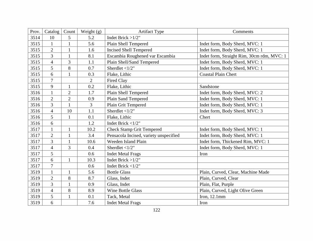
122
Prov. Catalog Count Weight (g) Artifact Type Comments
3514 10 5 5.2 Indet Brick >1/2"
3515 1 1 5.6 Plain Shell Tempered Indet form, Body Sherd, MVC: 1
3515 2 1 1.6 Incised Shell Tempered Indet form, Body Sherd, MVC: 1
3515 3 1 8.1 Escambia Roughened var Escambia Indet form, Straight Rim, 30cm rdm, MVC: 1
3515 4 3 1.1 Plain Shell/Sand Tempered Indet form, Body Sherd, MVC: 1
3515 5 8 0.7 Sherdlet <1/2" Indet form, Body Sherd, MVC: 1
3515 6 1 0.3 Flake, Lithic Coastal Plain Chert
3515 7 2 Fired Clay
3515 9 1 0.2 Flake, Lithic Sandstone
3516 1 2 1.7 Plain Shell Tempered Indet form, Body Sherd, MVC: 2
3516 2 2 0.9 Plain Sand Tempered Indet form, Body Sherd, MVC: 1
3516 3 1 3 Plain Grit Tempered Indet form, Body Sherd, MVC: 1
3516 4 10 1.1 Sherdlet <1/2" Indet form, Body Sherd, MVC: 3
3516 5 1 0.1 Flake, Lithic Chert
3516 6 1.2 Indet Brick <1/2"
3517 1 1 10.2 Check Stamp Grit Tempered Indet form, Body Sherd, MVC: 1
3517 2 1 3.4 Pensacola Incised, variety unspecified Indet form, Body Sherd, MVC: 1
3517 3 1 10.6 Weeden Island Plain Indet form, Thickened Rim, MVC: 1
3517 4 3 0.4 Sherdlet <1/2" Indet form, Body Sherd, MVC: 1
3517 5 0.6 Indet Metal Frags Iron
3517 6 1 10.3 Indet Brick >1/2"
3517 7 0.6 Indet Brick <1/2"
3519 1 1 5.6 Bottle Glass Plain, Curved, Clear, Machine Made
3519 2 8 8.7 Glass, Indet Plain, Curved, Clear
3519 3 1 0.9 Glass, Indet Plain, Flat, Purple
3519 4 8 8.9 Wine Bottle Glass Plain, Curved, Light Olive Green
3519 5 1 0.1 Tack, Metal Iron, 12.1mm
3519 6 7.6 Indet Metal Frags Iron

123
Prov. Catalog Count Weight (g) Artifact Type Comments
3519 7 3 0.7 Shot, Metal Lead, 4.7mm Diameter, Molded
3519 8 1 0.1 Shot, Metal Lead, 3.7mm Diameter, Cast
3519 9 12.8 Indet Metal Frags Lead
3519 10 0.1 Shell, Indet
3519 11 0.1 Land Snail
3519 12 17.2 Mortar
3519 13 130 602.1 Lithic Chunk Granite
3519 14 387.5 Indet Brick <1/2"
3519 15 335 8594 Indet Brick >1/2"
3519 16 1.2 Coal
3520 1 2.2 Indet Metal Frags Lead
3520 2 1 1.6 Nail, Whole Iron, 38.5mm, Cut
3520 3 0.9 Indet Metal Frags Iron
3520 4 31 175 Indet Brick >1/2"
3520 5 20.1 Indet Brick <1/2"
3520 6 40 19.1 Lithic Chunk
3521 1 1 4.9 Machine Part, Metal Indet
3521 2 2 2 Nail Frags Iron
3521 3 1 41.9 Nail, Whole Iron
3521 4 2.6 Indet Metal Frags Lead
3521 5 1 2 Button, Metal Pewter
3521 6 0.1 Gastropod, Indet
3521 7 51.7 Indet Brick <1/2"
3521 8 77 1582.3 Indet Brick >1/2"
3521 9 1 1305.5 Handmade Brick
3521 11 0.6 Coal
3522 1 4.6 Indet Metal Frags Pewter
3522 2 2 1.6 Nail Frags Iron

124
Prov. Catalog Count Weight (g) Artifact Type Comments
3522 3 1 26.4 Nail Frags 59.7mm
3522 4 273 Mortar
3522 5 77 9403.8 Indet Brick >1/2"
3522 6 54.3 Indet Brick <1/2"
3522 9 0.1 Fulgurite
3522 10 1 1080.7 Lithic Chunk Sandstone
3522 11 8 Wood Sample
3523 1 2 0.6 Glass, Indet Plain, Curved, Clear
3523 2 21.2 Indet Metal Frags Lead
3523 3 1 21.8 Nail Frags Iron
3523 4 4.5 Indet Metal Frags Iron
3523 5 134 8098 Indet Brick >1/2"
3523 6 1 2295.4 Handmade Brick
3523 7 102.4 Indet Brick <1/2"
3523 8 544.9 Mortar
3524 1 0.2 Indet Metal Frags Lead
3524 2 1 0.3 Nail Frags Iron, Cut
3524 3 1 1.2 Nail Frags Iron
3524 4 19.8 Indet Metal Frags Iron
3524 5 13 25.8 Lithic Chunk Granite
3524 6 15.8 Indet Brick <1/2"
3524 7 29 4165.6 Indet Brick >1/2"
3524 8 1 1093.2 Handmade Brick
3525 1 1 5.6 Nail, Whole Iron, 63.6mm, Cut
3525 2 1 2.9 Nail Frags Iron
3525 3 16.7 Indet Metal Frags Iron
3525 4 15.4 Indet Brick <1/2"
3525 5 27 504 Indet Brick >1/2"

125
Prov. Catalog Count Weight (g) Artifact Type Comments
3525 6 1 1453.5 Handmade Brick
3525 7 2 2292.9 Handmade Brick
3525 8 57.3 Coal
3526 1 0.1 Land Snail
3528 1 3 24.7 Bottle Glass Curved, White, Molded
3529 1 18.6 Wood Sample
3530 1 1 0.6 Glass, Indet Plain, Flat, Clear
3530 2 1 30.7 Spike, Metal Iron
3533 1 1 0.1 Glass, Indet Plain, Flat, Clear
3533 2 2 5.1 Nail Frags Iron
3533 3 4 Indet Metal Frags Iron
3533 4 0.1 Land Snail
3533 5 14 68.2 Indet Brick >1/2"
3533 6 24.9 Indet Brick <1/2"
3534 1 1 0.9 Nail Frags Iron
3534 2 1 0.1 Flake, Lithic Quartz
3534 3 5 15.5 Indet Brick >1/2"
3534 4 4.3 Indet Brick <1/2"
3536 1 44.4 Unmodified Clay
3537 1 13 0.9 Sherdlet <1/2" Indet form, Body Sherd, MVC: 1
3538 1 5 0.7 Glass, Indet Plain, Curved, Clear
3538 2 4 1.2 Glass, Indet Plain, Flat, Soda Lime
3538 3 1 132.7 Nail, Whole Iron
3538 4 4 6.6 Nail Frags Iron
3538 5 3.9 Indet Metal Frags Iron
3538 6 0.2 Seed, Indet
3538 7 1 0.1 Land Snail
3538 8 5 6.7 Indet Brick >1/2"

126
Prov. Catalog Count Weight (g) Artifact Type Comments
3538 9 6 Indet Brick <1/2"
3539 1 1 721.1 Nail, Whole Iron
3540 1 1 0.2 Glass, Indet Plain, Flat, Clear
3540 2 1 0.4 Glass, Indet Plain, Curved, Patinized
3540 3 1 0.1 Flake, Lithic Tallahatta Quartzite
3540 4 0.9 Seed, Indet
3540 5 5.9 Indet Brick <1/2"
3540 12 3 9 Nail Frags Iron
3541 1 13 2.8 Glass, Indet Plain, Curved, Clear
3541 2 3 9.7 Nail Frags Iron
3541 3 14.2 Indet Metal Frags Iron
3541 4 3 9 Indet Brick >1/2"
3541 5 5 Indet Brick <1/2"
3542 1 0.8 Indet Brick <1/2"
3543 2 0.1 Coal
3544 1 1 11 Nail, Whole Iron, 83mm
3545 1 1 20 Wood Sample
3548 1 1 434.7 Rod, Metal Iron
3548 2 1 363 Rod, Metal Iron
3549 1 1 1.7 Plain Shell Tempered Indet form, Body Sherd, MVC: 1
3549 2 4 0.7 Sherdlet <1/2" Indet form, Body Sherd, MVC: 1
3549 3 5 0.2 Glass, Indet Plain, Curved, Clear
3549 4 3 0.3 Glass, Indet Plain, Flat, Clear
3549 5 1 0.4 Shot, Metal Lead, 4.3mm Diameter, Molded
3549 6 0.9 Indet Metal Frags Lead
3549 7 10 2.3 Screen, Metal Brass
3549 8 3 0.2 Tack, Metal Iron
3549 9 1 1.1 Screen, Metal Iron

127
Prov. Catalog Count Weight (g) Artifact Type Comments
3549 10 9 37 Nail Frags Iron
3549 11 60.1 Indet Metal Frags Iron
3549 12 0.1 Bone, Indet
3549 13 0.1 Shell, Indet
3549 14 329.7 Indet Brick <1/2"
3549 15 170 1524.5 Indet Brick >1/2"
3549 17 2 0.6 Lithic Chunk Granite
3549 18 8.1 Coal
3550 1 1 4 Jefferson Check-stamped, variety Leon Indet form, Body Sherd, MVC: 1
3550 2 1 1.2 Chattahoochee Roughened var Chattahoochee Indet form, Body Sherd, MVC: 1
3550 3 1 0.2 Sherdlet <1/2" Indet form, Body Sherd, MVC: 1
3550 4 2 0.3 Glass, Indet Plain, Flat, Clear
3550 5 1 0.2 Hardware Screw, Metal Brass
3550 6 15.9 Indet Metal Frags Iron
3550 7 2 0.9 Lithic Chunk Granite
3550 8 69 1080 Indet Brick >1/2"
3550 9 149.5 Indet Brick <1/2"
3551 1 7 33.8 Indet Brick >1/2"
3551 2 5.6 Indet Brick <1/2"
3553 1 1 0.1 Glass, Indet Plain, Curved, Clear
3553 2 29.7 Indet Metal Frags Iron
3553 3 29 1495.5 Indet Brick >1/2"
3553 4 33.7 Indet Brick <1/2"
3553 5 10.1 Concrete
3554 1 1 1.9 Glass, Indet Plain, Curved, Clear
3554 2 1 44.5 Nail, Whole Iron, 117mm
3554 3 2 2.8 Nail Frags Iron
3554 4 7.6 Indet Metal Frags Iron

128
Prov. Catalog Count Weight (g) Artifact Type Comments
3554 5 0.3 Nail, Whole Brass
3554 6 0.3 Bone, Indet
3554 7 8.4 2043.2 Indet Brick >1/2"
3554 8 136.6 Indet Brick <1/2"
3554 9 47 Concrete
3555 1 2 1 Nail, Whole Iron
3555 2 4 4.7 Nail Frags Iron
3555 3 19.3 Indet Metal Frags Iron
3555 4 0.3 Bone, Indet
3555 5 17 151.7 Indet Brick >1/2"
3555 6 34.6 Indet Brick <1/2"
3556 1 2 0.6 Glass, Indet Plain, Curved, Clear
3556 4 0.7 Indet Metal Frags Brass
3556 5 6 50.6 Nail Frags Iron
3556 6 3.6 Indet Metal Frags Iron
3556 7 12 141.8 Indet Brick >1/2"
3556 8 12.2 Indet Brick <1/2"
3556 9 7 1.3 Nail, Whole Iron, Cut
3556 10 4 7.5 Nail, Whole Iron
3557 1 1 140 Hardware Chain, Metal Iron
3557 2 1 1069.7 Handmade Brick
3558 1 2 1 Glass, Indet Plain, Curved, Clear
3558 2 1 13.4 Nail, Whole Iron
3558 3 1 116.7 Nail, Whole Iron
3558 4 11 34.6 Nail Frags Iron
3558 5 11 1.9 Nail, Whole Iron
3558 6 30.7 Indet Metal Frags Iron
3558 7 2 0.1 Shot, Metal Lead, 4mm Diameter, Cast

129
Prov. Catalog Count Weight (g) Artifact Type Comments
3558 8 0.1 Bone, Indet
3558 9 1 743.3 Handmade Brick
3558 10 1 951.4 Handmade Brick
3558 11 24 3301.4 Indet Brick >1/2"
3558 12 80.7 Indet Brick <1/2"
3558 14 0.5 Coal
3558 18 1 0.1 Indet Object Rubber
3560 1 3 3.8 Nail Frags Iron
3560 2 0.5 Indet Metal Frags Iron
3560 3 1 709.9 Indet Brick >1/2"
3560 4 5 131.5 Indet Brick >1/2"
3560 5 5.3 Indet Brick <1/2"
3562 1 2 6.3 Walnut Roughened var McKee Island Indet form, Body Sherd, MVC: 1
3562 2 1 15 Plain Grog Tempered Bowl, Straight Rim, MVC: 1
3562 3 6 14.5 Plain Shell Tempered Indet form, Body Sherd, MVC: 2
3562 4 5 6.4 Plain Sand Tempered Indet form, Body Sherd, MVC: 2
3562 5 15 2.3 Sherdlet <1/2" Indet form, Body Sherd, MVC: 1
3562 6 0.8 Indet Metal Frags Iron
3562 7 3.7 Indet Brick <1/2"
3563 1 1 0.4 Incised Shell Tempered Indet form, Body Sherd, MVC: 1
3563 2 1 0.4 Incised Sand Tempered Indet form, Body Sherd, MVC: 1
3563 3 3 11.9 Plain Sand Tempered Indet form, Body Sherd, MVC: 1
3563 4 5 6.4 Plain Shell Tempered Indet form, Body Sherd, MVC: 1
3563 5 1 0.2 Burnished Shell Tempered, Plain Indet form, Body Sherd, MVC: 1
3563 6 1 2.2 Burnished Shell Tempered, Plain Indet form, Straight Rim, MVC: 1
3563 7 47 4.5 Sherdlet <1/2" Indet form, Body Sherd, MVC: 1
3563 8 1.9 Indet Brick <1/2"
3564 1 1 0.2 Incised Shell Tempered Indet form, Body Sherd, MVC: 1

130
Prov. Catalog Count Weight (g) Artifact Type Comments
3564 2 1 0.8 Plain Sand Tempered Indet form, Straight Rim, MVC: 1
3564 3 3 3.7 Plain Shell Tempered Indet form, Body Sherd, MVC: 1
3564 4 18 1.4 Sherdlet <1/2" Indet form, Body Sherd, MVC: 1
3565 1 1 0.1 Sherdlet <1/2" Indet form, Body Sherd, MVC: 1
3568 1 1 0.4 Sherdlet <1/2" Indet form, Body Sherd, MVC: 1
3568 2 1.7 Seed, Indet
3568 3 15 225 Indet Brick >1/2"
3568 4 20.7 Indet Brick <1/2"
3569 1 2 1.1 Plain Sand Tempered Indet form, Body Sherd, MVC: 1
3569 2 3 1.9 Plain Shell Tempered Indet form, Body Sherd, MVC: 1
3569 3 2 0.1 Sherdlet <1/2" Indet form, Body Sherd, MVC: 1
3569 4 1 Indet Metal Frags Brass
3569 5 18.2 Indet Metal Frags Iron
3569 6 19 128.4 Indet Brick >1/2"
3569 7 9.7 Indet Brick <1/2"
3569 11 0.2 Indet Object Plastic
3570 1 1 3.4 Plain Shell Tempered Indet form, Straight Rim, MVC: 1
3570 2 9 12.1 Plain Shell Tempered Indet form, Body Sherd, MVC: 1
3570 3 5 1.2 Sherdlet <1/2" Indet form, Body Sherd, MVC: 1
3570 5 3 7.1 Indet Brick >1/2"
3570 6 10.9 Indet Brick <1/2"
3571 1 1 0.6 Plain Grit Tempered Indet form, Body Sherd, MVC: 1
3571 2 8 9.1 Plain Shell Tempered Indet form, Body Sherd, MVC: 1
3571 3 6 1 Sherdlet <1/2" Indet form, Body Sherd, MVC: 1
3571 4 0.6 Indet Metal Frags Iron
3571 5 0.8 Concretion
3572 1 1 1.9 Walnut Roughened var McKee Island Indet form, Body Sherd, MVC: 1
3572 2 1 2 Moundville Incised, variety Snow's Bend Indet form, Body Sherd, MVC: 1

131
Prov. Catalog Count Weight (g) Artifact Type Comments
3572 3 7 16.4 Plain Shell Tempered Indet form, Body Sherd, MVC: 1
3572 4 3 1.4 Plain Sand Tempered Indet form, Body Sherd, MVC: 1
3572 5 24 3 Sherdlet <1/2" Indet form, Body Sherd, MVC: 1
3572 6 1.2 Indet Metal Frags Iron
3573 1 2 2.5 Incised Shell Tempered Indet form, Body Sherd, MVC: 1
3573 2 3 1.4 Plain Shell Tempered Indet form, Body Sherd, MVC: 1
3573 3 3 1.1 Sherdlet <1/2" Indet form, Body Sherd, MVC: 1
3574 1 6 0.1 Sherdlet <1/2" Indet form, Body Sherd, MVC: 1
3576 1 2 36.2 Indet Brick >1/2"
3577 1 2 0.4 Glass, Indet Plain, Curved, Clear
3577 2 1 0.2 Glass, Indet Plain, Flat, Clear
3577 3 2 6 Nail Frags Iron
3577 4 3 Indet Metal Frags
3577 5 0.1 Land Snail
3577 6 0.4 Seed, Indet
3577 7 1 1865.8 Handmade Brick
3577 8 978.6 Handmade Brick
3577 9 8 403.2 Indet Brick >1/2"
3577 10 46.9 Indet Brick >1/2"
3577 13 0.6 Coal
3577 16 1 1192.1 Indet Brick >1/2"
3578 1 1 262.3 Tack, Metal Iron, Hand Wrought
3578 2 1 54.1 Spike, Metal Iron
3578 3 1 36 Nail, Whole Iron
3578 4 3 0.6 Sherdlet <1/2" Indet form, Body Sherd, MVC: 1
3578 5 1 0.3 Wine Bottle Glass Plain, Curved, Light Olive Green
3578 6 2 0.1 Glass, Indet Plain, Curved, Clear
3578 7 8 8.9 Nail Frags Iron

132
Prov. Catalog Count Weight (g) Artifact Type Comments
3578 8 15.7 Indet Metal Frags Iron
3578 9 0.4 Indet Metal Frags Lead
3578 10 1 1 Nail, Whole Lead
3578 11 156 3504.2 Indet Brick >1/2"
3578 12 263.8 Indet Brick <1/2"
3578 13 1 841.9 Handmade Brick
3578 14 1 735.5 Handmade Brick
3578 15 1 774.7 Indet Brick >1/2"
3578 16 1 516.9 Handmade Brick
3578 17 3 4.8 Lithic Chunk Granite
3578 20 19 Coal
3578 25 0.1 Indet Object Fabric
3578 26 1 768.6 Indet Brick >1/2"
3578 27 1 831.5 Handmade Brick
3578 28 1 749.3 Handmade Brick
3578 29 1 1268.2 Handmade Brick
3578 30 1 996.5 Indet Brick >1/2"
3578 31 1 888.7 Handmade Brick
3578 32 1 755.7 Handmade Brick
3578 33 1 1471.5 Handmade Brick
3578 34 1 1522.4 Handmade Brick
3578 35 1 1024.8 Handmade Brick
3579 1 3 0.1 Glass, Indet Plain, Curved, Clear
3579 2 1 3.9 Nail Frags Iron
3579 3 1 6.6 Nail, Whole Iron, 63mm
3579 4 1 18.5 Trim, Metal Iron
3579 5 7.4 Indet Metal Frags Iron
3579 6 112 7333.2 Indet Brick >1/2"

133
Prov. Catalog Count Weight (g) Artifact Type Comments
3579 7 154.8 Indet Brick <1/2"
3579 8 1 572.6 Handmade Brick
3579 9 1 1175.5 Handmade Brick
3579 10 1 614.1 Handmade Brick
3579 11 1 502.3 Handmade Brick
3579 14 1.6 Coal
3579 16 1 0.6 Chunk, Lithic Utilized Quartz
3579 18 1 717 Handmade Brick
3579 19 1 544.4 Handmade Brick
3579 20 1 686.8 Indet Brick >1/2"
3579 21 1 817.3 Handmade Brick
3580 1 2 4.3 Nail Frags Iron
3580 2 1.1 Indet Metal Frags Iron
3580 3 48 1048.2 Indet Brick >1/2"
3580 4 57.1 Indet Brick <1/2"
3580 5 1 728.8 Handmade Brick
3580 6 1 1163.5 Handmade Brick
3580 7 1 1096.4 Handmade Brick
3580 11 693.4 Indet Brick >1/2"
3580 12 1 746.2 Indet Brick >1/2"
3580 13 1 1038.7 Indet Brick >1/2"
3581 1 2 0.1 Glass, Indet Plain, Flat, Clear
3581 2 1 1.1 Glass, Indet Plain, Curved, Clear
3581 3 2 0.6 Nail Frags Iron
3581 4 0.3 Indet Metal Frags Iron
3581 5 0.1 Shell, Indet
3581 6 281.7 Indet Brick <1/2"
3581 7 260 6470.4 Indet Brick >1/2"

134
Prov. Catalog Count Weight (g) Artifact Type Comments
3581 8 1 720.7 Handmade Brick
3581 9 1 924.8 Handmade Brick
3581 10 1 649.9 Handmade Brick
3581 11 0.1 Hardware Ring, Metal
3581 13 0.1 Fired Clay
3581 17 1 1318 Handmade Brick
3581 18 1 1275.3 Indet Brick >1/2"
3581 19 1 490.4 Indet Brick >1/2"
3581 20 1 1069.9 Indet Brick >1/2"
3582 1 1 2.2 Plain Sand Tempered Indet form, Body Sherd, MVC: 1
3582 2 1 0.4 Chattahoochee Roughened var Chattahoochee Indet form, Body Sherd, MVC: 1
3582 3 3 5.8 Nail Frags Iron, Cut
3582 4 4 1.5 Nail, Whole Iron
3582 5 406 5164.5 Indet Brick >1/2"
3582 6 253.3 Indet Brick <1/2"
3582 7 1 1130 Handmade Brick "J Gonzalez"
3582 8 1 697.9 Handmade Brick
3582 9 1 1234 Handmade Brick
3582 10 1 1311.7 Handmade Brick
3582 15 1 1012.7 Handmade Brick
3582 16 1 1442.1 Indet Brick >1/2"
3582 17 1 1515.4 Handmade Brick
3582 18 1 698.2 Handmade Brick
3582 19 1 777.3 Indet Brick >1/2"
3582 20 1 1249.3 Handmade Brick
3582 21 1 713 Indet Brick >1/2"
3583 1 2 3 Plain Sand Tempered Indet form, Body Sherd, MVC: 1
3583 2 2 0.2 Sherdlet <1/2" Indet form, Body Sherd, MVC: 1
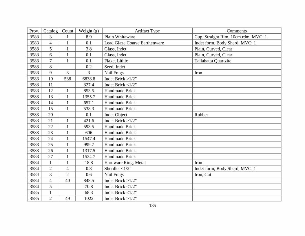
135
Prov. Catalog Count Weight (g) Artifact Type Comments
3583 3 1 8.9 Plain Whiteware Cup, Straight Rim, 10cm rdm, MVC: 1
3583 4 1 0.1 Lead Glaze Coarse Earthenware Indet form, Body Sherd, MVC: 1
3583 5 1 3.8 Glass, Indet Plain, Curved, Clear
3583 6 1 0.1 Glass, Indet Plain, Curved, Clear
3583 7 1 0.1 Flake, Lithic Tallahatta Quartzite
3583 8 0.2 Seed, Indet
3583 9 8 3 Nail Frags Iron
3583 10 538 6838.8 Indet Brick >1/2"
3583 11 327.4 Indet Brick <1/2"
3583 12 1 853.5 Handmade Brick
3583 13 1 1355.7 Handmade Brick
3583 14 1 657.1 Handmade Brick
3583 15 1 538.3 Handmade Brick
3583 20 0.1 Indet Object Rubber
3583 21 1 421.6 Indet Brick >1/2"
3583 22 1 593.5 Handmade Brick
3583 23 1 606 Handmade Brick
3583 24 1 1547.4 Handmade Brick
3583 25 1 999.7 Handmade Brick
3583 26 1 1317.5 Handmade Brick
3583 27 1 1524.7 Handmade Brick
3584 1 1 18.8 Hardware Ring, Metal Iron
3584 2 4 0.8 Sherdlet <1/2" Indet form, Body Sherd, MVC: 1
3584 3 2 0.6 Nail Frags Iron, Cut
3584 4 40 848.5 Indet Brick >1/2"
3584 5 70.8 Indet Brick <1/2"
3585 1 68.3 Indet Brick <1/2"
3585 2 49 1022 Indet Brick >1/2"
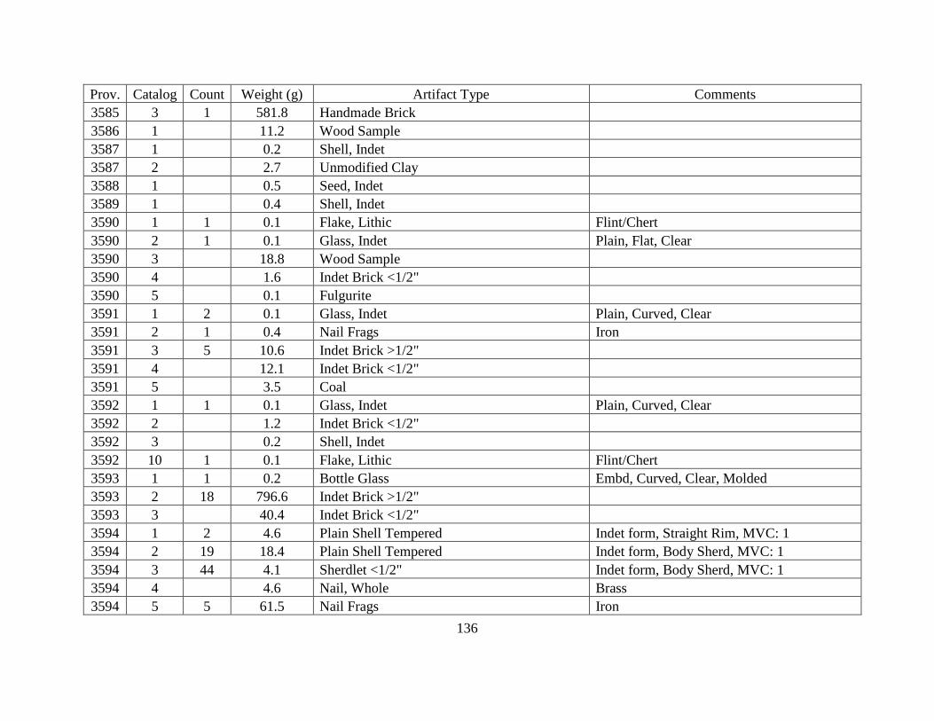
136
Prov. Catalog Count Weight (g) Artifact Type Comments
3585 3 1 581.8 Handmade Brick
3586 1 11.2 Wood Sample
3587 1 0.2 Shell, Indet
3587 2 2.7 Unmodified Clay
3588 1 0.5 Seed, Indet
3589 1 0.4 Shell, Indet
3590 1 1 0.1 Flake, Lithic Flint/Chert
3590 2 1 0.1 Glass, Indet Plain, Flat, Clear
3590 3 18.8 Wood Sample
3590 4 1.6 Indet Brick <1/2"
3590 5 0.1 Fulgurite
3591 1 2 0.1 Glass, Indet Plain, Curved, Clear
3591 2 1 0.4 Nail Frags Iron
3591 3 5 10.6 Indet Brick >1/2"
3591 4 12.1 Indet Brick <1/2"
3591 5 3.5 Coal
3592 1 1 0.1 Glass, Indet Plain, Curved, Clear
3592 2 1.2 Indet Brick <1/2"
3592 3 0.2 Shell, Indet
3592 10 1 0.1 Flake, Lithic Flint/Chert
3593 1 1 0.2 Bottle Glass Embd, Curved, Clear, Molded
3593 2 18 796.6 Indet Brick >1/2"
3593 3 40.4 Indet Brick <1/2"
3594 1 2 4.6 Plain Shell Tempered Indet form, Straight Rim, MVC: 1
3594 2 19 18.4 Plain Shell Tempered Indet form, Body Sherd, MVC: 1
3594 3 44 4.1 Sherdlet <1/2" Indet form, Body Sherd, MVC: 1
3594 4 4.6 Nail, Whole Brass
3594 5 5 61.5 Nail Frags Iron

137
Prov. Catalog Count Weight (g) Artifact Type Comments
3594 6 1.2 Indet Metal Frags Iron
3594 7 55.7 Indet Brick <1/2"
3594 8 51 1394.3 Indet Brick >1/2"
3594 9 1 1083.3 Handmade Brick
3594 10 1 724.4 Handmade Brick
3594 13 0.3 Coal
3595 1 0.1 Shell, Indet
3598 1 1 0.1 Wine Bottle Glass Plain, Curved, Light Olive Green
3598 2 0.1 Land Snail
3598 3 3 14.4 Indet Brick >1/2"
3598 4 9.5 Indet Brick <1/2"
3598 5 1 1555.6 Handmade Brick
3598 6 1 853.5 Handmade Brick "J Gonzalez"
3598 7 1 717.4 Handmade Brick "J Gonzalez"
3599 1 1 0.6 Plain Grog Tempered Indet form, Flat Rim, MVC: 1
3599 2 1 1.1 Wine Bottle Glass Plain, Curved, Light Olive Green
3599 3 1 0.1 Glass, Indet Plain, Curved, Clear
3599 4 2 0.5 Glass, Indet Plain, Curved, Clear
3599 5 1 1.5 Nail, Whole Iron, 39mm, Cut
3599 6 9 10.6 Nail Frags Iron, Cut
3599 7 2.6 Indet Metal Frags Iron
3599 8 2 1.2 Nail, Whole Copper, Machine Made
3599 9 0.2 Indet Metal Frags Lead
3599 10 1 0.1 Lithic Chunk Granite
3599 11 1 0.1 Graphite Graphite
3599 12 75 655 Indet Brick >1/2"
3599 13 86 Indet Brick <1/2"
3600 1 3 3 Nail Frags Iron

138
Prov. Catalog Count Weight (g) Artifact Type Comments
3600 2 1 0.3 Flake, Lithic Quartzite
3600 3 0.1 Land Snail
3600 4 2.1 279 Indet Brick >1/2"
3600 5 19.8 Indet Brick <1/2"
3601 1 4 2.1 Plain Shell Tempered Indet form, Body Sherd, MVC: 1
3601 2 4 0.1 Sherdlet <1/2" Indet form, Body Sherd, MVC: 1
3601 3 2.8 Indet Metal Frags Iron
3601 4 4 21.5 Indet Brick >1/2"
3601 5 2.3 Indet Brick <1/2"
3604 1 1 2.6 Plain Shell Tempered Indet form, Body Sherd, MVC: 1
3604 2 3 0.8 Glass, Indet Plain, Curved, Clear
3604 3 1 8.7 Nail, Whole Iron, 78.2mm, Cut
3604 4 1 2.3 Nail Frags Iron, Cut
3604 5 1 2.5 Nail Frags Iron, Cut
3604 6 1 2.5 Nail Frags Iron
3604 7 0.6 Indet Brick <1/2"
3605 1 1 1.4 Alachua Cob Marked Indet form, Body Sherd, MVC: 1
3605 2 5 5.2 Plain Shell Tempered Indet form, Body Sherd, MVC: 2
3605 3 9 9.8 Plain Sand Tempered Indet form, Body Sherd, MVC: 4
3605 4 29 9.7 Sherdlet <1/2" Indet form, Body Sherd, MVC: 1
3605 5 2 0.1 Glass, Indet Plain, Curved, Clear
3605 6 2 11.5 Trim, Metal Iron, Cut
3605 7 1 5 Nail, Whole Iron, 62.4mm, Cut
3605 8 6 10.5 Nail, Whole Iron, 37mm, Cut
3605 9 15 23 Nail Frags Iron, Cut
3605 10 29.1 Indet Metal Frags Iron
3605 11 1.6 Indet Metal Frags Lead
3605 12 3 1.1 Lithic Chunk Granite

139
Prov. Catalog Count Weight (g) Artifact Type Comments
3605 13 1 0.1 Flake, Lithic Tallahatta Quartzite
3605 14 20 122 Indet Brick >1/2"
3605 15 35.6 Indet Brick <1/2"
3605 16 41.6 Mortar
3605 17 0.2 Coal
3606 1 4.4 Indet Metal Frags Iron
3606 2 0.2 Indet Brick <1/2"
3607 1 1 2 Hardware Screw, Metal Iron, 40.5mm, Machine Made
3607 2 1 2.4 Nail, Whole Iron, 55.5mm, Machine Made
3607 3 2 3.5 Nail Frags Iron
3607 4 2.9 Indet Metal Frags Iron
3607 5 0.1 Land Snail
3607 6 6 28.5 Indet Brick >1/2"
3607 7 24.3 Indet Brick <1/2"
3608 1 1 0.1 Glass, Indet Plain, Curved, Clear
3608 2 3 10.8 Nail Frags Iron
3608 3 181.5 Indet Brick <1/2"
3608 4 37 146.9 Indet Brick >1/2"
3609 1 1 6.2 Nail, Whole Iron, 75.8mm, Cut
3609 2 2 3.2 Nail, Whole Iron, 37.5mm, Cut
3609 3 11 22.2 Nail Frags Cut
3609 4 10 45.6 Nail Frags Iron
3609 5 19.9 Indet Metal Frags Iron
3609 6 0.1 Land Snail
3609 7 424.4 Indet Brick <1/2"
3609 8 248 731.5 Indet Brick >1/2"
3609 9 635.4 Concretion
3610 1 1 0.3 Glass, Indet Plain, Flat, Clear

140
Prov. Catalog Count Weight (g) Artifact Type Comments
3610 2 1.2 Indet Brick <1/2"
3611 1 2 0.1 Glass, Indet Plain, Curved, Clear
3611 3 3.4 Indet Brick <1/2"
3611 7 3.1 Plastic Bag Plastic
3612 1 1 0.1 Glass, Indet Plain, Curved, Clear
3612 2 0.9 Indet Metal Frags Iron, Machine Made
3612 3 3 314.9 Indet Brick >1/2"
3612 4 3.8 Indet Brick <1/2"
3613 1 1 384.1 Bottle Glass, Flask Embd, Curved, Clear, Cup btm, Iridescent
3614 1 0.1 Fossil
3614 2 2 16.4 Indet Metal Frags Iron, Machine Made
3614 3 1 Indet Metal Frags Iron
3614 4 10.9 Indet Brick <1/2"
3614 5 14 152.5 Indet Brick >1/2"
3615 1 2 1.5 Sherdlet <1/2" Indet form, Body Sherd, MVC: 1
3617 1 4 3.2 Plain Shell Tempered Indet form, Body Sherd, MVC: 1
3617 2 4 13 Nail Frags Iron
3617 3 2.9 Unmodified Clay
3617 4 14.3 Fired Clay
3618 1 2 0.7 Plain Shell Tempered Indet form, Body Sherd, MVC: 1
3618 2 4 2.1 Plain Sand Tempered Indet form, Body Sherd, MVC: 2
3618 3 7 1.7 Sherdlet <1/2" Indet form, Body Sherd, MVC: 1
3619 1 12 26.9 Plain Sand Tempered Indet form, Body Sherd, MVC: 1
3619 2 94 31.2 Sherdlet <1/2" Indet form, Body Sherd, MVC: 1
3619 3 3 17.7 Nail, Whole Iron, 75.5mm, Cut
3619 4 1 1.7 Nail, Whole Iron, 38.5mm, Cut
3619 5 1 1.2 Staple, Metal Iron
3619 6 8 53.7 Indet Metal Frags Iron, Cut

141
Prov. Catalog Count Weight (g) Artifact Type Comments
3619 7 21.2 Indet Metal Frags Iron
3619 8 34.4 Indet Metal Frags Lead
3619 9 1 0.1 Lithic Chunk Flint, Gray
3619 10 78 265.7 Indet Brick >1/2"
3619 11 108 Indet Brick <1/2"
3619 12 206.7 Concretion
3620 1 0.8 Fired Clay
3622 1 2 0.3 Glass, Indet Plain, Flat, Clear
3622 2 1 0.1 Glass, Indet Plain, Curved, Clear
3622 3 10.7 Indet Metal Frags Iron
3622 4 0.1 Bone, Indet
3622 5 13 126.6 Indet Brick >1/2"
3622 6 38 Indet Brick <1/2"
3622 12 1 0.2 Glass, Indet Plain, Flat, Soda Lime
3622 13 0.2 Shell, Indet
3623 1 1 15.1 Concretion
3623 2 0.9 Indet Metal Frags Iron
3623 3 1 0.1 Shot, Metal Lead, 3.6mm Diameter, Dropped
3623 4 3.7 Indet Brick <1/2"
3624 1 1 10.8 Nail, Whole Iron, 60.5mm
3624 2 1.3 Indet Metal Frags Iron
3624 3 1.8 Indet Brick <1/2"
3625 1 4 1.3 Glass, Indet Plain, Flat, Clear
3625 2 3.1 Indet Metal Frags Iron
3625 3 2 0.4 Hardware Ring, Metal Iron
3625 4 4 8.1 Nail Frags Iron
3625 5 19 56.6 Indet Brick >1/2"
3625 6 30.6 Indet Brick <1/2"

142
Prov. Catalog Count Weight (g) Artifact Type Comments
3626 1 1 0.6 Button, Metal Iron
3626 2 1 25.9 Spike, Metal Iron, 96.8mm
3626 3 12 50.2 Nail Frags Iron
3626 4 5.1 Indet Metal Frags Iron
3626 5 193.1 Wood Sample
3626 6 15 36 Indet Brick >1/2"
3626 7 15.5 Indet Brick <1/2"
3627 1 2 1.8 Nail Frags Iron
3627 2 1.3 Indet Metal Frags Iron
3627 3 2 5.5 Indet Brick >1/2"
3628 1 1 0.1 Glass, Indet Plain, Curved, Clear
3628 2 2 25 Nail Frags Iron
3628 3 12.6 Indet Metal Frags Iron
3628 4 8 57.9 Indet Brick >1/2"
3628 5 12.6 Indet Brick <1/2"
3629 1 1 25.4 Nail, Whole Iron, 115.3mm
3629 2 1 0.4 Plain Sand Tempered Indet form, Body Sherd, MVC: 1
3629 3 4 1.1 Glass, Indet Plain, Flat, Clear
3629 4 1 1.5 Nail Frags Iron
3629 5 0.9 Indet Metal Frags Iron
3629 6 9 255.3 Indet Brick >1/2"
3629 7 17.2 Indet Brick <1/2"
3630 1 1 1.2 Glass, Indet Plain, Flat, Clear
3630 2 2 4.9 Nail Frags Iron
3630 3 0.1 Bone, Indet
3630 4 25 335.5 Indet Brick >1/2"
3630 5 31.9 Indet Brick <1/2"
3631 1 6 1.9 Glass, Indet Plain, Flat, Clear
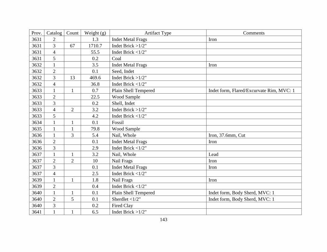
143
Prov. Catalog Count Weight (g) Artifact Type Comments
3631 2 1.3 Indet Metal Frags Iron
3631 3 67 1710.7 Indet Brick >1/2"
3631 4 55.5 Indet Brick <1/2"
3631 5 0.2 Coal
3632 1 3.5 Indet Metal Frags Iron
3632 2 0.1 Seed, Indet
3632 3 13 469.6 Indet Brick >1/2"
3632 4 36.8 Indet Brick <1/2"
3633 1 1 0.7 Plain Shell Tempered Indet form, Flared/Excurvate Rim, MVC: 1
3633 2 22.5 Wood Sample
3633 3 0.2 Shell, Indet
3633 4 2 3.2 Indet Brick >1/2"
3633 5 4.2 Indet Brick <1/2"
3634 1 1 0.1 Fossil
3635 1 1 79.8 Wood Sample
3636 1 3 5.4 Nail, Whole Iron, 37.6mm, Cut
3636 2 0.1 Indet Metal Frags Iron
3636 3 2.9 Indet Brick <1/2"
3637 1 1 3.2 Nail, Whole Lead
3637 2 2 10 Nail Frags Iron
3637 3 0.1 Indet Metal Frags Iron
3637 4 2.5 Indet Brick <1/2"
3639 1 1 1.8 Nail Frags Iron
3639 2 0.4 Indet Brick <1/2"
3640 1 1 0.1 Plain Shell Tempered Indet form, Body Sherd, MVC: 1
3640 2 5 0.1 Sherdlet <1/2" Indet form, Body Sherd, MVC: 1
3640 3 0.2 Fired Clay
3641 1 1 6.5 Indet Brick >1/2"
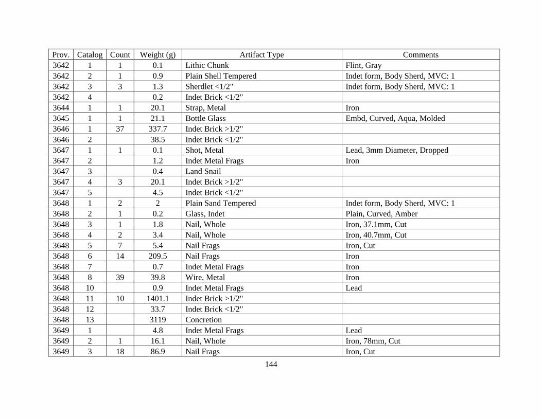
144
Prov. Catalog Count Weight (g) Artifact Type Comments
3642 1 1 0.1 Lithic Chunk Flint, Gray
3642 2 1 0.9 Plain Shell Tempered Indet form, Body Sherd, MVC: 1
3642 3 3 1.3 Sherdlet <1/2" Indet form, Body Sherd, MVC: 1
3642 4 0.2 Indet Brick <1/2"
3644 1 1 20.1 Strap, Metal Iron
3645 1 1 21.1 Bottle Glass Embd, Curved, Aqua, Molded
3646 1 37 337.7 Indet Brick >1/2"
3646 2 38.5 Indet Brick <1/2"
3647 1 1 0.1 Shot, Metal Lead, 3mm Diameter, Dropped
3647 2 1.2 Indet Metal Frags Iron
3647 3 0.4 Land Snail
3647 4 3 20.1 Indet Brick >1/2"
3647 5 4.5 Indet Brick <1/2"
3648 1 2 2 Plain Sand Tempered Indet form, Body Sherd, MVC: 1
3648 2 1 0.2 Glass, Indet Plain, Curved, Amber
3648 3 1 1.8 Nail, Whole Iron, 37.1mm, Cut
3648 4 2 3.4 Nail, Whole Iron, 40.7mm, Cut
3648 5 7 5.4 Nail Frags Iron, Cut
3648 6 14 209.5 Nail Frags Iron
3648 7 0.7 Indet Metal Frags Iron
3648 8 39 39.8 Wire, Metal Iron
3648 10 0.9 Indet Metal Frags Lead
3648 11 10 1401.1 Indet Brick >1/2"
3648 12 33.7 Indet Brick <1/2"
3648 13 3119 Concretion
3649 1 4.8 Indet Metal Frags Lead
3649 2 1 16.1 Nail, Whole Iron, 78mm, Cut
3649 3 18 86.9 Nail Frags Iron, Cut

145
Prov. Catalog Count Weight (g) Artifact Type Comments
3649 4 1 203.2 Spike, Metal Iron, 133.5mm, Cut
3649 5 1 33.3 Nail, Whole Iron
3649 6 1 371.9 Nail, Whole Iron
3649 7 3 72.9 Nail, Whole Iron
3649 8 5 48 Wire, Metal Iron
3649 9 1 6.9 Hardware Screw, Metal Iron
3649 10 1 41.4 Nail Frags Iron, Cut
3649 11 10.1 Indet Metal Frags Iron
3649 12 2 1449.3 Bolt, Metal Iron, 209.8mm
3649 13 0.1 Land Snail
3649 14 44 150.2 Indet Brick >1/2"
3649 15 70.6 Indet Brick <1/2"
3649 16 72.8 Fired Clay
3649 18 1671 Concretion
3650 1 7 0.2 Sherdlet <1/2" Indet form, Body Sherd, , MVC: 1
3650 2 1 242.4 Bolt, Metal Iron
3650 3 1 76.5 Nail, Whole Iron
3650 4 2 1.4 Nail, Whole Iron, 27.8mm, Cut
3650 5 5 16.4 Nail Frags Iron, Cut
3650 6 94.1 Indet Metal Frags Iron
3650 7 0.4 Bone, Indet
3650 8 165.2 Indet Brick <1/2"
3650 9 1 411.6 Handmade Brick
3650 10 1 870 Handmade Brick
3650 11 153 2009.3 Indet Brick >1/2"
3650 13 0.7 Coal
3651 1 3 12.8 Nail Frags Iron, Cut
3651 2 1 78.7 Spike, Metal Iron
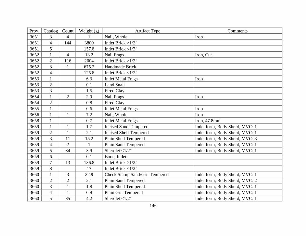
146
Prov. Catalog Count Weight (g) Artifact Type Comments
3651 3 4 1 Nail, Whole Iron
3651 4 144 3800 Indet Brick >1/2"
3651 5 157.8 Indet Brick <1/2"
3652 1 4 13.2 Nail Frags Iron, Cut
3652 2 116 2004 Indet Brick >1/2"
3652 3 1 675.2 Handmade Brick
3652 4 125.8 Indet Brick <1/2"
3653 1 6.3 Indet Metal Frags Iron
3653 2 0.1 Land Snail
3653 3 1.5 Fired Clay
3654 1 2 2.9 Nail Frags Iron
3654 2 0.8 Fired Clay
3655 1 0.6 Indet Metal Frags Iron
3656 1 1 7.2 Nail, Whole Iron
3658 1 0.7 Indet Metal Frags Iron, 47.8mm
3659 1 1 1.7 Incised Sand Tempered Indet form, Body Sherd, MVC: 1
3659 2 1 2.1 Incised Shell Tempered Indet form, Body Sherd, MVC: 1
3659 3 11 15.2 Plain Shell Tempered Indet form, Body Sherd, MVC: 3
3659 4 2 1 Plain Sand Tempered Indet form, Body Sherd, MVC: 1
3659 5 34 3.9 Sherdlet <1/2" Indet form, Body Sherd, MVC: 1
3659 6 0.1 Bone, Indet
3659 7 13 136.8 Indet Brick >1/2"
3659 8 17 Indet Brick <1/2"
3660 1 3 22.9 Check Stamp Sand/Grit Tempered Indet form, Body Sherd, MVC: 1
3660 2 2 2.1 Plain Sand Tempered Indet form, Body Sherd, MVC: 2
3660 3 1 1.8 Plain Shell Tempered Indet form, Body Sherd, MVC: 1
3660 4 1 0.9 Plain Grit Tempered Indet form, Body Sherd, MVC: 1
3660 5 35 4.2 Sherdlet <1/2" Indet form, Body Sherd, MVC: 1

147
Prov. Catalog Count Weight (g) Artifact Type Comments
3661 1 1 3.6 Plain Sand Tempered Indet form, Body Sherd, MVC: 1
3661 2 3 0.8 Sherdlet <1/2" Indet form, Body Sherd, MVC: 1
3661 3 1.4 Indet Brick >1/2"
3664 1 1 1.5 Plain Shell Tempered Indet form, Body Sherd, MVC: 1