modelling spatial patterns of vegetation in desert sand dunes · modelling spatial patterns of...
TRANSCRIPT

Modelling Spatial Patterns of Vegetation in Desert Sand Dunes Thomas Littmann1,2 Maik Veste3,4*
1University of Halle-Wittenberg, Institute of Geography, Von-Seckendorff-Platz 4, D-06099 Halle, Germany 2Present address: DLC-Dr. Littmann Consulting, Leibnizstr. 33, D-58256 Ennepetal, Germany 3University of Bielefeld, Department of Ecology, PO Box 100131, D-33501 Bielefeld, Germany 4Present address: University of Hohenheim, Institute of Botany and Botanical Garden, Garbenstrasse 30, 70559 Stuttgart, Germany ABSTRACT A stochastic numerical approach was developed to model the actual standing biomass in the sand dunes of the northwestern Negev (Israel) and probable boundary conditions that may be responsible for the vegetation patterns investigated in detail. Our results for several variables characteristic for the prevailing climate, geomorphology, hydrology and biologicy at four measurement stations along a transect from northwest to southeast allowed for the development of a stochastic model for biomass distribution over the entire sand dune field (mesoscale) and at Nizzana experimental station (microscale). With this equation it was possible to compute and interpolate a biomass index value for each grid point on the mesoscale and micro scale. The spatial distribu-tion of biomass is negatively linked to distance from the sea, to rainfall and relief energy. KEY WORDS arid ecosystems, modelling, biomass, Negev, Nizzana
1 Introduction
Vegetated sand dunes are typical of several arid and semi-arid deserts. They occur e.g. in the Kalahari, the Sinai and Negev Deserts and Inner Mongolia, northern China. Spatial distribution of the vegetation and its height play important roles in the formation of these sand dune systems (Tsoar and Møller 1986, Thomas 1988). Sand dune fields are predominantly fixed by standing biomass while the degree of sand dune stabi-lization will largely depend on the spatial patterns of the perennial vegetation cover. However, those pat-terns are effectively controlled only by two abiotic boundary conditions: a) sand movement as the equi-librium dynamics of stable and mobile units (Littmann and Gintz 2000) and b) local water availability (Yair et al. 1997, Veste et al. 2006). The dunes of the Si-nai-Negev sand fields are separated by a political border which leads to different land-use practices and vegetation cover. Intensive grazing and trampling by goats, sheep and camels resulted in desertification on the Egyptian side, whereas on the Israeli side the vegetation remained undisturbed for several decades (Tsoar et al. 1995). Sand mobilisation is very often a huge problem of desertification in such regions (Ma-inguet 1999). Therefore, sand dunes fixation and res-toration of a natural vegetation cover are major tasks in combating desertification (Sun and Fang 2001; Sanbei Shelter-Forest System Construction Bureau 1999).
In general, vegetation pattern and biomass produc-
tivity in deserts depend mainly on the rainfall regime and soil water availability. As a result of various fac-tors a distinctive vegetation pattern may be observed. In extreme arid regions the vegetation is concentrated around runoff channels, dry valleys and depressions where surface runoff is collected. In sandy habitats with annual rainfall above 100 mm, the vegetation pattern is more diffuse (Danin 1983). However, in the sand dunes of the northwestern Negev a small scale mosaic distribution of vegetation is found and various habitat types can be distinguished (Veste 1995). More detailed knowledge about the spatial distribution of biomass may be of great importance, especially for the restoration of areas affected by desertification.
In this paper we will present a novel simple nu-merical approach to model the actual standing bio-mass distribution of a small area within a sand dune field of the northwestern Negev (Israel) near Nizzana and discuss probable boundary conditions that may be responsible for the vegetation patterns investigated in detail.
2 Study area
2.1 Geography and climate The sand dunes of the northwestern Negev are the
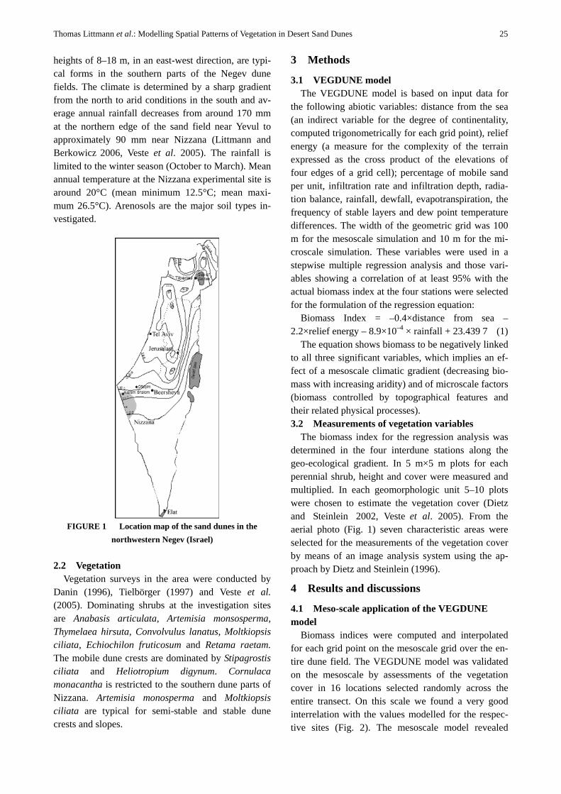
eastern most part of the sand field covering the north-ern part of the Sinai Peninsula and the northwestern Negev (Fig. 1). In the southern parts the dunes are linear in an east-west direction (Fig. 1), whereas north of the Wadi Nizzana the dunes are a combination of barchanoid and longitudinal dunes. Linear dunes with
*Author for correspondence. E-mail: [email protected] Forestry Studies in China, 7(4): 24–28
Thomas Littmann et al.: Modelling Spatial Patterns of Vegetation in Desert Sand Dunes 25
heights of 8–18 m, in an east-west direction, are typi-cal forms in the southern parts of the Negev dune fields. The climate is determined by a sharp gradient from the north to arid conditions in the south and av-erage annual rainfall decreases from around 170 mm at the northern edge of the sand field near Yevul to approximately 90 mm near Nizzana (Littmann and Berkowicz 2006, Veste et al. 2005). The rainfall is limited to the winter season (October to March). Mean annual temperature at the Nizzana experimental site is around 20°C (mean minimum 12.5°C; mean maxi-mum 26.5°C). Arenosols are the major soil types in-vestigated.
FIGURE 1 Location map of the sand dunes in the
northwestern Negev (Israel)
2.2 Vegetation Vegetation surveys in the area were conducted by
Danin (1996), Tielbörger (1997) and Veste et al. (2005). Dominating shrubs at the investigation sites are Anabasis articulata, Artemisia monsosperma, Thymelaea hirsuta, Convolvulus lanatus, Moltkiopsis ciliata, Echiochilon fruticosum and Retama raetam. The mobile dune crests are dominated by Stipagrostis ciliata and Heliotropium digynum. Cornulaca monacantha is restricted to the southern dune parts of Nizzana. Artemisia monosperma and Moltkiopsis ciliata are typical for semi-stable and stable dune crests and slopes.
3 Methods
3.1 VEGDUNE model The VEGDUNE model is based on input data for
the following abiotic variables: distance from the sea (an indirect variable for the degree of continentality, computed trigonometrically for each grid point), relief energy (a measure for the complexity of the terrain expressed as the cross product of the elevations of four edges of a grid cell); percentage of mobile sand per unit, infiltration rate and infiltration depth, radia-tion balance, rainfall, dewfall, evapotranspiration, the frequency of stable layers and dew point temperature differences. The width of the geometric grid was 100 m for the mesoscale simulation and 10 m for the mi-croscale simulation. These variables were used in a stepwise multiple regression analysis and those vari-ables showing a correlation of at least 95% with the actual biomass index at the four stations were selected for the formulation of the regression equation:
Biomass Index = –0.4×distance from sea – 2.2×relief energy – 8.9×10⁻⁴ × rainfall + 23.439,7 (1)
The equation shows biomass to be negatively linked to all three significant variables, which implies an ef-fect of a mesoscale climatic gradient (decreasing bio-mass with increasing aridity) and of microscale factors (biomass controlled by topographical features and their related physical processes). 3.2 Measurements of vegetation variables
The biomass index for the regression analysis was determined in the four interdune stations along the geo-ecological gradient. In 5 m×5 m plots for each perennial shrub, height and cover were measured and multiplied. In each geomorphologic unit 5–10 plots were chosen to estimate the vegetation cover (Dietz and Steinlein 2002, Veste et al. 2005). From the aerial photo (Fig. 1) seven characteristic areas were selected for the measurements of the vegetation cover by means of an image analysis system using the ap-proach by Dietz and Steinlein (1996).
4 Results and discussions
4.1 Meso-scale application of the VEGDUNE model
Biomass indices were computed and interpolated for each grid point on the mesoscale grid over the en-tire dune field. The VEGDUNE model was validated on the mesoscale by assessments of the vegetation cover in 16 locations selected randomly across the entire transect. On this scale we found a very good interrelation with the values modelled for the respec-tive sites (Fig. 2). The mesoscale model revealed

26 Forestry Studies in China, Vol.7, No.4, 2005
patches of high standing biomass in small depressions between steep sand dune slopes in many parts of the southern dune field, irrespective of rainfall totals. It is shown that the biomass index is negatively linked to rainfall (Eq. 1) and this is a most interesting finding, pointing to patches of higher standing biomass in fa-vourable habitats over the entire sand dune field— especially in the higher sand dunes of the southern, drier part—of the study area. In several other studies a positive correlation was shown between annual rain-fall and standing biomass (Noy-Meir 1973, Seely 1978, Kutiel and Lavee 1999). Reasons for the nega-tive correlation are changes of surface properties. In the entire dune system a so called biological soil crusts has been built up by cyanobacteria, green algae, mosses and lichens which play important roles in the ecosystems (Veste et al. 2001, 2006, Veste 2005). Along the transect, infiltration rates decrease from south to north and compensate the effects of increas-ing rainfall for the standing crop (Littmann et al. 1998, Veste et al. 2005).
FIGURE 2 Correlation between measured vegetation
cover and modelled cover for validation of the VEGDUNE model
4.2 Microscale application of the VEGDUNE model
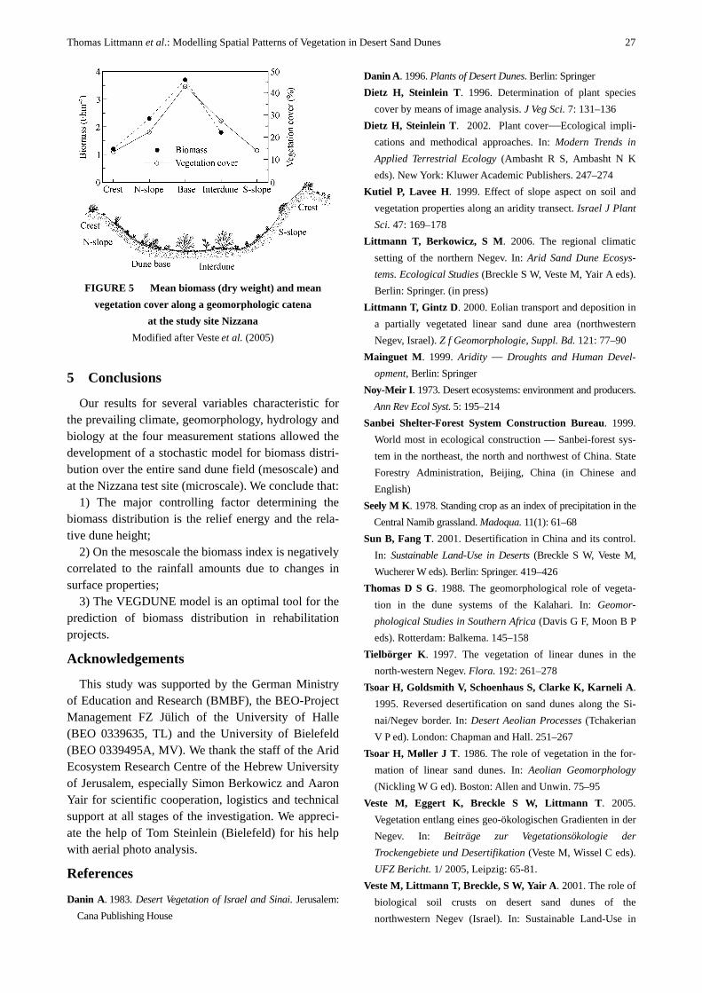
After the validation of the biomass data on the mesoscale the equation was applied to the microscale on a digital surface model of Nizzana. The output of the microscale model shows a very realistic simulation of the spatial pattern of standing biomass in the sand dunes at Nizzana (Fig. 3). Measurements of the vege-tation cover of the area by image analysis of aerial photography confirmed these findings (Fig. 4). At the Nizzana site the highest vegetation cover occurs at the
dune base, whereas the lowest density can be found on the mobile dune crests (Fig. 5). In this ecotope sand stability is another controlling factor for the vegetation (Littmann and Gintz 2000). The relative dune height (expressed as relief energy) is one major factor for the ecotope differentiation. The vegetation has also a feedback on the near-ground wind velocity and on sand mobility. Nevertheless, stable dunes and dune bases are favourable habitats for shrubs from the viewpoint of their water relations (Veste et al. 2006). Deep infiltration in good rainy years leads to subsur-face flow and additional water supply at the dune base (Yair et al. 1997) resulting in a dense vegetation cover up to 45% (Fig. 5). However, the biomass on the south-facing slopes was partly overestimated. These steep dune slopes are not covered by biological soil crusts and the mobile sand prevents the establishment of more vegetation. The data provided in Fig. 5 show as well a close relationship between standing biomass and vegetation cover for the sand dune vegetation. Only few studies show such a close relationship (Dietz and Steinlein 2002). From these it can be concluded that the biomass index modelled by the VEGDUNE model reflects the standing biomass as well as the vegetation cover.
FIGURE 3 Modelled biomass indices on the sand dunes
of Nizzana (see Fig. 1)
FIGURE 4 Modelled biomass index (from Fig. 3) and
measured vegetation cover from airphoto
Thomas Littmann et al.: Modelling Spatial Patterns of Vegetation in Desert Sand Dunes 27
FIGURE 5 Mean biomass (dry weight) and mean
vegetation cover along a geomorphologic catena at the study site Nizzana
Modified after Veste et al. (2005)
5 Conclusions
Our results for several variables characteristic for the prevailing climate, geomorphology, hydrology and biology at the four measurement stations allowed the development of a stochastic model for biomass distri-bution over the entire sand dune field (mesoscale) and at the Nizzana test site (microscale). We conclude that:
1) The major controlling factor determining the biomass distribution is the relief energy and the rela-tive dune height;
2) On the mesoscale the biomass index is negatively correlated to the rainfall amounts due to changes in surface properties;
3) The VEGDUNE model is an optimal tool for the prediction of biomass distribution in rehabilitation projects.
Acknowledgements
This study was supported by the German Ministry of Education and Research (BMBF), the BEO-Project Management FZ Jülich of the University of Halle (BEO 0339635, TL) and the University of Bielefeld (BEO 0339495A, MV). We thank the staff of the Arid Ecosystem Research Centre of the Hebrew University of Jerusalem, especially Simon Berkowicz and Aaron Yair for scientific cooperation, logistics and technical support at all stages of the investigation. We appreci-ate the help of Tom Steinlein (Bielefeld) for his help with aerial photo analysis.
References
Danin A. 1983. Desert Vegetation of Israel and Sinai. Jerusalem: Cana Publishing House
Danin A. 1996. Plants of Desert Dunes. Berlin: Springer Dietz H, Steinlein T. 1996. Determination of plant species
cover by means of image analysis. J Veg Sci. 7: 131–136 Dietz H, Steinlein T. 2002. Plant cover—Ecological impli-
cations and methodical approaches. In: Modern Trends in Applied Terrestrial Ecology (Ambasht R S, Ambasht N K eds). New York: Kluwer Academic Publishers. 247–274
Kutiel P, Lavee H. 1999. Effect of slope aspect on soil and vegetation properties along an aridity transect. Israel J Plant Sci. 47: 169–178
Littmann T, Berkowicz, S M. 2006. The regional climatic setting of the northern Negev. In: Arid Sand Dune Ecosys-tems. Ecological Studies (Breckle S W, Veste M, Yair A eds). Berlin: Springer. (in press)
Littmann T, Gintz D. 2000. Eolian transport and deposition in a partially vegetated linear sand dune area (northwestern Negev, Israel). Z f Geomorphologie, Suppl. Bd. 121: 77–90
Mainguet M. 1999. Aridity — Droughts and Human Devel-opment, Berlin: Springer
Noy-Meir I. 1973. Desert ecosystems: environment and producers. Ann Rev Ecol Syst. 5: 195–214
Sanbei Shelter-Forest System Construction Bureau. 1999. World most in ecological construction — Sanbei-forest sys-tem in the northeast, the north and northwest of China. State Forestry Administration, Beijing, China (in Chinese and English)
Seely M K. 1978. Standing crop as an index of precipitation in the Central Namib grassland. Madoqua. 11(1): 61–68
Sun B, Fang T. 2001. Desertification in China and its control. In: Sustainable Land-Use in Deserts (Breckle S W, Veste M, Wucherer W eds). Berlin: Springer. 419–426
Thomas D S G. 1988. The geomorphological role of vegeta-tion in the dune systems of the Kalahari. In: Geomor-phological Studies in Southern Africa (Davis G F, Moon B P eds). Rotterdam: Balkema. 145–158
Tielbörger K. 1997. The vegetation of linear dunes in the north-western Negev. Flora. 192: 261–278
Tsoar H, Goldsmith V, Schoenhaus S, Clarke K, Karneli A. 1995. Reversed desertification on sand dunes along the Si-nai/Negev border. In: Desert Aeolian Processes (Tchakerian V P ed). London: Chapman and Hall. 251–267
Tsoar H, Møller J T. 1986. The role of vegetation in the for-mation of linear sand dunes. In: Aeolian Geomorphology (Nickling W G ed). Boston: Allen and Unwin. 75–95
Veste M, Eggert K, Breckle S W, Littmann T. 2005. Vegetation entlang eines geo-ökologischen Gradienten in der Negev. In: Beiträge zur Vegetationsökologie der Trockengebiete und Desertifikation (Veste M, Wissel C eds). UFZ Bericht. 1/ 2005, Leipzig: 65-81.
Veste M, Littmann T, Breckle, S W, Yair A. 2001. The role of biological soil crusts on desert sand dunes of the northwestern Negev (Israel). In: Sustainable Land-Use in

28 Forestry Studies in China, Vol.7, No.4, 2005
Deserts (Breckle S W, Veste M, Wucherer W eds). Heidelberg: Springer Publisher. 357–367
Veste M, Littmann T, Russow R, Breckle S W. 2006. Eco-system processes and vegetation pattern in arid sand dunes: Nizzana, Negev as an example. In: Proceeding of the International Symposium on Restoration and Stability of Arid and Semi-Arid Ecosystems (Sun B et al. eds). Beijing: Sci-ence Publisher (in press)
Veste M. 1995. Structures of geomorphological and ecological units and ecoystems processes in the linear dune system near
Nizzana, Bielefelder Ökologische Beiträge. 8: 85–96 Veste M. 2005. The importance of biological soil crusts for
rehabilitation of degraded arid and semi-arid ecosystems. Science of Soil and Water Conservation (in press)
Yair A, Lavee H, Greitser N. 1997. Spatial and temporal vari-ability of water percolation and movement in a system of longitudinal dunes, western Negev, Israel. Hydrological Processes. 11: 43–58
(Received August 20, 2005 Accepted October 12, 2005)
Subscription Information
The Forestry Studies in China (ISSN 1008–1321), abstracted and indexed by Chemical Abstracts (USA), CABI and other famous databases, is published quarterly, respectively in March, June, September and December. The Editorial Office of Forestry Studies in China is in charge of its editing, printing and distribution. The 2006 annual subscription prices for mainland China are 60 Yuan RMB, for other countries and regions USD 80, including both postage and handling. Subscription to: Mr. Cheng Pengjun, Editorial Office of Forestry Studies in China, Box 148 Beijing Forestry University, Beijing 100083, P. R. China
Email: [email protected] Fax: 86-10-62337605 Tel: 86-10-62337915