modelling distance measurement equipment (dme) signals ... · modelling distance measurement...
TRANSCRIPT

Article preprint
Modelling Distance Measurement Equipment (DME)signals interfering an airborne GNSS receiver
This is the peer reviewed version of the following article: Modelling Distance Measure-ment Equipment (DME) signals interfering an airborne GNSS receiver, which has beenaccepted for publication in �nal form in the Journal of Navigation and can be foundin the �nal version at https://www.ion.org/publications/browse.cfm.It will be published in the summer issue of NAVIGATION,
Journal of the Institute of Navigation, Vol. 65, No. 2. 2018
If you want to cite this article: Please use:
BIBTEX
@article{Steingass:18,
author = {Alexander Steingass and Thanawat Thiasiriphet and Jaron Samson},
title = {Modelling Distance Measurement Equipment (DME) signals
interfering an airborne GNSS receiver},
year = {2018},
journal = {NAVIGATION, Journal of the Institute of Navigation},
editor = {ION - Institute of Navigation},
month = {Summer},
address = {8551 Rixlew Ln., STE 360 Manassas, VA 20109, USA},
issue = {65, No. 2},
ISSN = {0028-1522}
}
Plaintext
Steingass, Alexander and Thanawat, Thiasiriphet and Samson, Jaron (2018)
Modelling Distance Measurement Equipment (DME) signals
interfering an airborne GNSS receiver.
Navigation, Journal of the Institute of Navigation,
8551 Rixlew Ln., STE 360 Manassas, VA 20109, USA.
Institute of navigation.
Issue 65, No. 2, summer 2018.
ISSN 0028-1522
Please note: The model download is currently under construction. It will be availablesoon � at least when the paper is published.

Modelling Distance Measurement Equipment (DME)signals interfering an airborne GNSS receiver
Alexander Steingass∗1, Thanawat Thiasiriphet†1 and Jaron Samson‡2
1German Aerospace Center - DLR2European Space Agency - ESA
March 1, 2018
Abstract
This publication describes an end-to-endmodel to generate Distance MeasurementEquipment (DME) signals as an interfer-ence source to airborne Global SatelliteNavigation Systems (GNSS).
Both satellite navigation systems, theGlobal Positioning System (GPS) andGALILEO, use the lower L-band1 for wide-band navigation services and are sharingthe same frequency band with DME. AnyGNSS Receiver operating in the mentionedbands will receive DME signals and willhave to deal with them as interference. Thispublication describes a model to rebuild themeasured DME signals at the receiver inputto allow simulations of the interference ef-fect. Prior to this work we only found mod-els based on propagation estimation. No
∗[email protected]†[email protected]‡[email protected]: E5 1164-1215MHz,GPS L5 1164-1189MHz
model existed which is based on real worldmeasurements of DME signals. Thus, theGerman Aerospace Center (DLR) has car-ried out a �ight measurement campaign atthe European DME hotspot near Frankfurt(Main), Germany. From the data of themeasurement campaign we have developedthe new model. This measurement basedmodel is much more accurate than the ex-isting models since it accounts for the prop-agation and the DME transmission and theGNSS receiver antenna e�ects. We providethis model to the community to allow amore realistic forecast of the DME-GNSSinterference situation.
1 Introduction
During the de�nition phase of the Euro-pean satellite navigation system GALILEO,it was obvious to use the L1 band for thecore part of the system. The use of L1was mainly based on the requirement to becompatible with the GPS system. To fa-
1

1 INTRODUCTION 2
cilitate the advanced civil receivers an au-tonomous ionosphere correction a secondfrequency band was needed. As the L bandis densely allocated, the choice was made touse the E52 band. Especially for civil avi-ation a band with a protected bandwidthwas necessary. The E5a band was selectedsince this band already had a frequency pro-tection namely for the distance measuringequipment DME [2].
The DME system radiates short twinpulses each of a duration of 6µs and with apower of up to 2 kW. The DME system al-lows to estimate the distance from the air-craft to a ground station. In order thatGALILEO or GPS can coexist with theDME system in the E5 band such GNSSreceivers have to be robust against DMEinterference.
Previous publications [17, 15, 16, 6] pro-pose theoretically based models to simulatethe DME signal strength at the GNSS an-tenna output of the aircraft.
The basic approach to mitigate the DMEsignal is blanking the received pulses byshutting down the antenna input during apulse. This blanking approach reduced theinterference of the DME signal on the onehand but reduces as well the power of thesatellite signal. Already [12] came to theconclusion that the "(DME) Power levelis important" but the DME power level isonly a theoretical estimation at the mo-ment. [8, 27, 20, 19] underlined the impor-tance of future measurements.
Only a very small number of publicationsare based on real world measurements orexperiments [24, 29]. In these publicationsreal world GPS signals and DME signals
21164-1214MHz
had been measured together by using GPSreceivers which had been modi�ed to ap-ply signal blanking techniques for DME sig-nal mitigation. The GPS receiver had beenmounted in an aircraft �ying over an Euro-pean test area. As a result we get real worldmeasurement, which is important but onlyvalid for a GPS signal and the selected re-ceiver using the selected blanking method.A generic, GNSS signal and receiver in-dependent measurement based interferencemodel is still missing.In general there is a lack of location and
altitude dependent measurement data forstrength and pulse load of received DMEsignals. Therefore the German AerospaceCentre (DLR) conducted a detailed mea-surement campaign in 2009 where the DLRteam recorded the received GNSS signalsand their interference in the L1 and E5 bandduring �ight tests. This experiment hasbeen published [30]. Recorded signal snap-shots have been used to estimate the inter-ference e�ects on GALILEO receivers [3] byregenerating the DME signal with an arbi-trary wave form generator (AWG) and over-laying the DME signal with a GALILEOsignal that had been generated by a hard-ware GALILEO signal generator.After these tests, a systematic data eval-
uation has been carried out, which resultsin a generic DME interference model, whichis capable to generate an interference sce-nario from the ICAO COM3 [22] databaseand which is veri�ed against the measure-ments. The successful veri�cation o�ers avalidated model to the navigation commu-nity.This article publishes the veri�ed model
which rebuilds the DME signals as an in-terference situation at a GNSS antenna of

2 PROPAGATION EFFECTS 3
an aircraft. Although it is relatively easyto measure the pattern of a GNSS antennaon a test stand it is di�cult to measurethe antenna diagram while the antenna ismounted on the aircraft, taking into ac-count the e�ect of the metal fuselage. Ourevaluation of the recorded DME signals to-gether with geometric information such asposition, roll pitch an yaw of the aircraft,allowed us to derive an antenna - fuselagemodel. In contrast to other theory basedDME interference models [33, 28] that donot consider the GNSS antenna and fuse-lage e�ects our model is measurement basedand includes the aircraft fuselage.Considering the DME ground as well as
the GNSS aircraft antenna the new DMEinterference model allows an end-to-endsimulation from the DME transmitters tothe aircraft GNSS antenna output.
2 Propagation E�ects
Precise modelling requires precise propa-gation estimation. In Europe the mostdense DME hotspot has been estimatednear Frankfurt (Main) in Germany at theway point RUDUS3 [25]. From transmitterantenna input to receiver output the follow-ing attenuations and gains are relevant:
Radio Horizon
The radio horizon D is the minimumdistance from the aircraft to a DME sta-tion beyond which no reception was pos-sible. In order to model di�raction of ra-dio waves around the Earth surface manypublications [10] corrected the radio hori-
3 50◦2'51.32" N, 8◦4'41.77" E
zon by calculating an "e�ective Earth ra-dius" that equals usually 4
3times the physi-
cal radius of the Earth. This approach leadsto higher distances from where stations canbe received. In our measurements we founda good match between our measured radiohorizon and the radio horizon being calcu-lated with the physical Earth radius. Thuswe conclude that di�raction is not applica-ble in this case, likely due to the high RFfrequencies in L�band.To calculate the radio horizon let re be
the physical radius of the Earth, ha the al-titude of the aircraft above mean sea level(MSL) and hs the height of the stationabove MSL, then we found
D =√(re + ha)2 − r2e +
√(re + hs)2 − r2e
(1)Equation 1 can be reformulated to:
D =√h2a + 2reha +
√h2s + 2rehs (2)
as the radio horizon D.Assuming a receiver on the sea surface
(ha = 0) equation 2 results in:
D =√h2s + 2rehs (3)
Since the altitude of the station is muchless than the radius of the earth, equation3 can be approximated to:
D ≈√2rehs (4)
This equation is well known as maritimeradio horizon [11].

2 PROPAGATION EFFECTS 4
Transmitter Antenna
Nearly all DME stations in Germany areusing the Kathrein "FAN 86" DME An-tenna [18]. Thus we use the FAN 86 an-tenna model for all transmitting stations.The FAN 86 consists of vertically stackeddipole antennae, which are powered by aphase shift array to achieve the maximumpower density at an elevation of 5◦ as spec-i�ed in [23]. Every single of the used dipoleantennas shows a null4 at the zenith. There-fore the combination of these dipole anten-nas also shows a null pointing to the zenith.
Terrain Attenuation
We have observed strong attenuations byhills and mountain chains such as the Alps5.Wherever a DME station was optically in-visible by terrain, a reception was impossi-ble. One reason why RUDUS is a hot spotis that for aircraft position more south thanRUDUS in Germany many stations in orbehind the Alps are blocked. At RUDUSthe radio horizon is located just in front ofthe Alps for an aircraft being at 40.000 ftMSL. [31] provides propagation curves forL-band at 1200MHz. The most importantoutcome of [31] is that the propagation lossequals the free space loss as long as the sta-tion is optically visible. Behind the horizonthe propagation loss drops so rapidly belowany relevant detection level that we can ne-glect these stations.
Free Space Loss
The free space loss GFSL is well knownwith GFSL ∝ 1
D2 . Attenuations by atmo-
4A null of an antenna is the direction from whereno signal can be received.
5Central European mountain chain
spheric e�ects and gases are not relevantfor the E5 frequency band.
Aircraft Antenna
Although the pattern of the antenna it-self is known in detail (compare [21], Page15 Figure 5 et. al. or [26], Page 12 Figure3) when installing the antenna on the air-craft fuselage, the pattern of the combinedantenna-fuselage changes dramatically, es-pecially in the lower hemisphere, due tonear �eld interaction between the fuselageand antenna. In the considered scenariowe are generating a DME signal as interfer-ence source to GNSS. Thus, we have useda typical dual frequency satellite navigationpatch antenna for the measurement whichwas mounted on the top of the aircraft nearthe cockpit pointing towards the sky forbest satellite reception. This antenna lo-cation is very di�erent from the locationof DME reception antennas that are placedbelow the fuselage of the aircraft to havebest DME reception.
For interference scenarios often a"straight and levelled" �ight is assumedfor a typical scenario [33] or the aircraftantenna and its orientation is neglected atall [28]. We see the necessity for accuratemodelling of the aircraft's attitude torepresent relevant scenarios.
For evaluating the measurement data, weused the ID sequence of the DME groundstations to identify to which DME stationsthe received pulses belong to. This assign-ment worked well even though a lot of DMEpulses had been received simultaneously.During the measurement the �ight manage-ment system (FMS) and the data recordinghad been synchronized by time stamping

2 PROPAGATION EFFECTS 5
both data streams. From the detected IDof the DME station we determined its loca-tion from the COM3 database [22]. Takinginto account the received power of ID pulsestogether with aircraft's attitude (from gy-roscopes of FMS) and position data (FMS)and the DME ground station location wewere able to determine the aircraft antennagain for every speci�c transmission comingfrom a speci�c direction. Eventually con-sidering all available measurements we wereable to calibrate the antenna diagram fora typical GNSS antenna that is interferingwith the aircraft its mounted on.Figure 1(a) shows the result of this evalu-
ation where each spot shows the median ofall ID pulse receptions. Please recall thatthe median and the mean are identical as-suming a Gaussian distribution. In Figure1(a) the aircraft nose is at (az = 0◦, elev =0◦).The standard manoeuvre for an aircraft
is the two minute turn [1] which results in abanking angle of about 30◦ for our measure-ment aircraft. The dashed lines in Figures1(a) and 1(b) are showing the horizon linefor 40◦ banking. Below the horizon line theDME signal was picked up seldom. Thismight be surprising at the �rst hand sincewe did �y straight over the stations, butprecise calculations con�rmed that a smalldeviation of the aircraft from the stationszenith results in a big elevation derivationfrom the horizon. Furthermore due to thenull at the Zenith the antenna is showing acone shaped area where no reception can oc-cur. We used the seldom contacts to DMEstations in the lower hemisphere and calcu-lated an average gain of -15 dB. With thisgain we �lled all data points where we hadno reception.
(a) Raw data from measurement
(b) Smoothed by sperical harmonics degree 20
Figure 1: Antenna pattern derived frommeasurements - Gain in dB

2 PROPAGATION EFFECTS 6
Since DME stations are situated on theground we have no gain information in theupper hemisphere. Therefore we �lled thisarea with samples representing 0 dB that re-sult in the orange colour.The high angular resolution of data
points is showing a quite scattered Fig-ure. To smooth the angular data and stillaccount for every data point we followedthe spherical harmonics analysis [32]. Thespherical harmonics approach determines aseries of coe�cients by projecting the origi-nal data onto spherical harmonic functions.These represent a complete series of or-thonormal functions. An important prop-erty is that the coe�cients are decreasingwith raising degree. So they can be used asa smoothing �lter by setting higher coe�-cients to zero.In Figure 1(b) we have applied the spheri-
cal harmonic method. Now a smoother an-tenna pattern can be seen. The most im-portant feature of Figure 1(b) is the �ndingthat the antenna gain at the horizon is sig-ni�cantly attenuated (blue belt at the hori-zon) between 30 to 40 dB. Referring againto the often assumed "straight and levelled"�ight [33] it is clear that the real antennapattern plays a signi�cant role since nearlyall stations are received from the horizon,thus most of the stations are signi�cantlyattenuated.This strong attenuation at the horizon
for a fuselage mounted antenna can also befound in other publications even if other fre-quencies, antenna types and aircraft typesare used [14] (Figure 5 and 6), [13] (Fig-ure 13 and 15). Thus, we conclude thatthe strong horizon attenuation is in�ictedby the aircraft fuselage. Thus the smoothedantenna diagram should show this attenua-
tion e�ect as well.Also an important �nding is the antenna
gain from stations below the horizon line:Here we have measured an attenuation of20 to 25 dB.We can see �uctuations in the region
above and below the levelled horizon linebetween the dashed lines. We assume thatthese high and low spots are generatedby constructive and destructive interferencefrom the direct path and paths re�ected bythe fuselage or even refracted paths. Re-visiting [13] (Figure 13) and [14] (Figure 4and 5) show similar �uctuations as we seein Figure 1(b). Thus a smoothed diagramshould show this �uctuation e�ect as well.Baring in mind these two e�ects we can
now adapt the smoothing level using thespherical harmonic functions for the mea-surement antenna in a way, that these �uc-tuations are well visible and the scatter ef-fects caused by the high resolution disap-pear. By comparing di�erent smoothinglevels we came to the result, that a smooth-ing level of 20 as shown in Figure 1(b) ful�lsthese requirements very well. Thus we rec-ommend this degree of smoothing for theantenna.Beside proper representation of the air-
craft antenna we conclude that the orienta-tion of the aircraft plays a major role. Withthe real antenna pattern the critical sce-narios can be identi�ed and simulated pre-cisely.With these new �ndings we see the last
turn to the �nal approach as such an exem-plary scenario. In the �nal approach phasethe GNSS requirements are much higherthan for an en route scenario and the bank-ing brings potential DME stations into en-hanced view. Further investigations should
3 THE MODEL 7
clarify if there might be other �ight scenar-ios where a worse interference situation mayoccur than at the hot spot RUDUS.
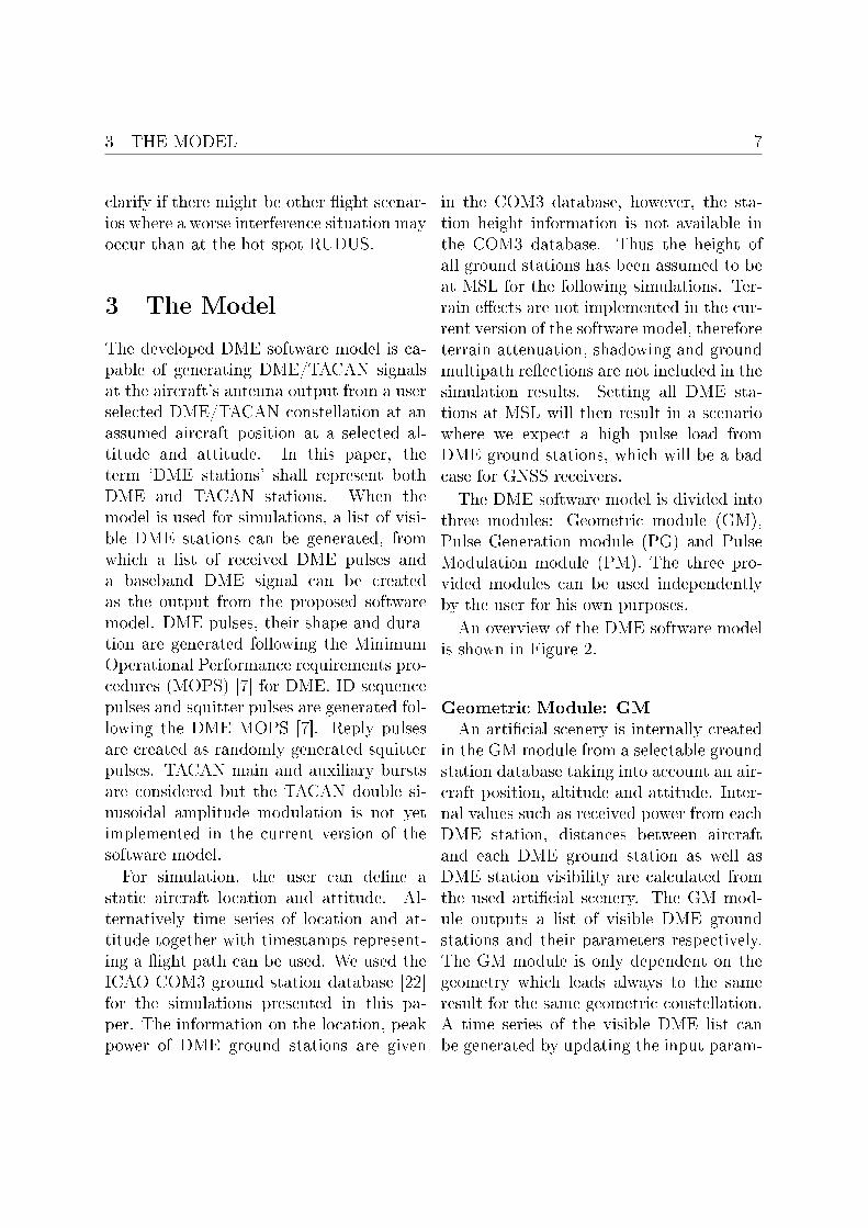
3 The Model
The developed DME software model is ca-pable of generating DME/TACAN signalsat the aircraft's antenna output from a userselected DME/TACAN constellation at anassumed aircraft position at a selected al-titude and attitude. In this paper, theterm 'DME stations' shall represent bothDME and TACAN stations. When themodel is used for simulations, a list of visi-ble DME stations can be generated, fromwhich a list of received DME pulses anda baseband DME signal can be createdas the output from the proposed softwaremodel. DME pulses, their shape and dura-tion are generated following the MinimumOperational Performance requirements pro-cedures (MOPS) [7] for DME. ID sequencepulses and squitter pulses are generated fol-lowing the DME MOPS [7]. Reply pulsesare created as randomly generated squitterpulses. TACAN main and auxiliary burstsare considered but the TACAN double si-nusoidal amplitude modulation is not yetimplemented in the current version of thesoftware model.
For simulation, the user can de�ne astatic aircraft location and attitude. Al-ternatively time series of location and at-titude together with timestamps represent-ing a �ight path can be used. We used theICAO COM3 ground station database [22]for the simulations presented in this pa-per. The information on the location, peakpower of DME ground stations are given
in the COM3 database, however, the sta-tion height information is not available inthe COM3 database. Thus the height ofall ground stations has been assumed to beat MSL for the following simulations. Ter-rain e�ects are not implemented in the cur-rent version of the software model, thereforeterrain attenuation, shadowing and groundmultipath re�ections are not included in thesimulation results. Setting all DME sta-tions at MSL will then result in a scenariowhere we expect a high pulse load fromDME ground stations, which will be a badcase for GNSS receivers.
The DME software model is divided intothree modules: Geometric module (GM),Pulse Generation module (PG) and PulseModulation module (PM). The three pro-vided modules can be used independentlyby the user for his own purposes.
An overview of the DME software modelis shown in Figure 2.
Geometric Module: GM
An arti�cial scenery is internally createdin the GM module from a selectable groundstation database taking into account an air-craft position, altitude and attitude. Inter-nal values such as received power from eachDME station, distances between aircraftand each DME ground station as well asDME station visibility are calculated fromthe used arti�cial scenery. The GM mod-ule outputs a list of visible DME groundstations and their parameters respectively.The GM module is only dependent on thegeometry which leads always to the sameresult for the same geometric constellation.A time series of the visible DME list canbe generated by updating the input param-

3 THE MODEL 8
Figure 2: Overview of DME software mod-ules
eters of the created arti�cial scenery at dif-ferent aircraft positions, altitudes and atti-tudes with corresponding time stamps.
Pulse generation Module: PG
The PG module requires a list of DMEvisible stations (usually the output from theGM module) and outputs a list of DMEpulse-pairs seen at the aircraft antenna out-put in a given time duration. The gener-ated list contains information of each DMEpulse pair such as power, frequency, phaseand time. The PG module is fully time de-pendent. Starting time and length of thesimulation is set by the user as an inputparameter.
Pulse modulation Module: PM
The PM module is used to create a base-band discrete-time, sampled DME signalfrom a list of DME pulse-pairs (usually theoutput from the PG module). The user se-lects the sampling frequency and centre ra-dio frequency (bandpass centre frequency)of the signal to be generated.
The main idea of dividing the DMEmodel into modules is to give the user �ex-ibility for simulations. For example: Ifthe simulation is only intended to simulatethe visibility of the DME ground stations,solely the GM module is needed. If theuser is looking for a pulse statistic the out-put from the GM module and the PG mod-ule are to be chosen. Finally using the fullsimulation chain of GM, PG and PM mod-ule will result in a fully sampled RF signalready to be used with an arbitrary signalgenerator (AWG).
The coherent time simulation concept forthe PG module opens the door for di�er-ent types of simulations: For example, astatistical DME signal analysis at one air-craft location can be performed by varyingonly the starting time of the PG module.Another example is the simulation of twodi�erent aircraft positions with the samestarting simulation time. In this case, thetwo simulated aircraft positions will resultin the same pulse-pairs with di�erent prop-agation parameters.
The received DME signal at the antennaoutput can be simulated in time segmentsto prevent an overload of the computer'smemory. For example, a �ight of one hourcan be partially simulated in blocks of 3msof DME received signal, which is then gen-

4 RESULTS AND COMPARISON 9
erated every 30 s.
Finally, the DME baseband signal gener-ated by the PM module can be uploadedto a hardware signal generator for radiofrequency signal generation. In the soft-ware we provide an interface for an AgilentE8267D AWG signal generator.
4 Results and Compari-
son
We developed a software model which cangenerate the received DME signal at theoutput of the aircraft antenna from a DMEdatabase taking into account the aircraftposition, altitude and attitude. The devel-oped DME software model will be veri�edby comparing its output to the �ight mea-surement data.
For this comparison we generated theDME signal for the aircraft at the loca-tion RUDUS at �ight level FL3906. (≈11.88 km) and FL50 (≈1.52 km). The pub-lic ICAO COM3 database [22] was used fordetermining the ground station parameters.The heights of the stations are not includedin the COM3 database, thus all stationswere assumed to be located at MSL. TheKathrein FAN 86 DME Antenna [18] wasused as the DME ground antenna model.The aircraft antenna diagram smoothed bysperical harmonics degree 20 as shown inFigure 1(b) was selected as the aircraft an-tenna model. The radio horizon was cal-culated using equation 2 with an assump-tion that the ground stations are located at
6FL denotes the '�ight level' which is de�ned asa vertical altitude at standard pressure, nominallyexpressed in hundreds of feet.
MSL. The simulation was performed onlyfor the DME stations transmitting in theE5 band. In the following we will use twocriteria for the comparison: Visibility ofDME ground stations from the aircraft anda comparison of the received DME signal atthe aircraft.
Visibility Comparison
As the �rst quality criteria we comparethe visibility of DME ground stations, lim-ited by the radio horizon between our modeland the measurements.
For the simulation, we determine thepure visibility of the DME ground stationsaccording to the radio horizon regardless ofthe power level of the received DME signals.In this case, only the aircraft position is in-�uencing the DME ground station visibility.The aircraft orientation is not in�uencingthe visibility of the DME station, since itleads only to an additional attenuation ofthe received DME signal. The visibility isan output parameter generated by the GMmodule.
The number of visible stations at the lo-cation RUDUS for FL390 and FL50 fromthe measurement and the simulation aresummarized in Table 1. For FL50, the num-ber of 11 visible stations from the measure-ment and the simulation are matched per-fectly. For FL390, the measurement datashows that 69 DME stations had been visi-ble at the aircraft while the result from themodel shows that 78 stations should be vis-ible.
The visibility of the DME ground sta-tions for FL390 observed in the �ight mea-surement data and at the output from theDME software model are shown in Figure 3.

4 RESULTS AND COMPARISON 10
Table 1: Number of visible stations at thelocation RUDUS for FL390 and FL50 fromthe measurement and the simulation.
FL390 FL50Measurement 69 11Simulation 78 11
The aircraft location is marked with a 'plus'in the middle of the �gures. The radio hori-zon calculated with equation 2 is visual-ized as a dashed circle. The visible DMEstations are marked with blue dots whilethe non-visible stations are marked with redcrosses.
Some stations located within the radiohorizon had not been visible in the measure-ment data recorded at the aircraft. Thise�ect is most likely caused by terrain at-tenuation and shadowing. For example,a TACAN station 'SDI' located in Saint-Dizier, France had not been visible in themeasurement data that had been receivedat RUDUS but this station is located withinthe calculated radio horizon. The SDI sta-tion is located at a height of 150m aboveMSL. Between the SDI station and the mea-surement aircraft at RUDUS the Hunsrück,which is a hill chain with altitude up to816m above MSL, can be found. Thereforethe signal from the SDI station had beenblocked by the terrain during the measure-ment. This e�ect was not rebuilt by themodel since no terrain model was imple-mented.
Another model deviation is, that DMEstations beyond the calculated radio hori-zon can be visible in the measurement databut not in the model. This happens if DMEstations are located higher than MSL which
is a mismatch between the real and mod-elled height. A notable example is the DMEstation 'CVA' located in Switzerland, onthe Piz Corvatsch mountain with a height of3296m above MSL. The model result showsthis station as invisible seen from RUDUS,since it is located behind the radio hori-zon, but it had been visible in the measure-ments because of its exposed location andheight. If the correct height is provided tothe model, the CVA station shows up as vis-ible in the model results. We have carriedout this visibility comparison for a lot ofother locations and came to the same goodconsistency as shown for the previous twoexamples.
By comparing the result from the mea-surement and the simulation in Figure 3,we conclude that the visibility of model andmeasurements matches very well. We canalso conclude that the usage of the phys-ical Earth radius, and not its 4
3modi�ed
value, is correct to calculate the radio hori-zon (compare equation 2 in section 2).
Signal comparison
As the second quality criteria for themodel, we compare the power of the re-ceived DME signal at the output of the air-craft antenna, between our model and themeasurements. Please keep in mind thatthe DME software model randomly gener-ates pulse-pairs with the statistical valuesfrom the DME standard. Thus simulatedsignals are obviously not the exact sameas the measurement data. The importantproperty for comparison is that the mod-elled DME power levels, pulse rates and IDsignatures resemble the measurement data.
Figure 4 shows the comparison of the re-

5 CONCLUSION 11
Figure 3: Comparison of the DME/TACANground station visibility for FL390.
ceived DME signals from the measurementdata and the DME signals generated by themodel. The waterfall diagram of the mea-sured and modelled signals for the locationRUDUS at �ight levels FL390 and FL50are shown in the upper and lower part ofFigure 4(a) and Figure 4(b), respectively.
Power level of higher than -66 dBm is rep-resented by black, while white is used forlower.
The modelled DME signal and the mea-sured signal is very similar. For FL390, thepower levels of the measured and modelledstations are showing a good match. TheTACAN bursts can be well seen in bothcases. For FL50, the number of visibleDME stations matches perfectly. Again thepower level is very similar. Since the air-craft is �ying at low altitude the chance ofterrain blockage is reduced. Notable com-parison point is the ID sequence transmit-ted by the TACAN station 'BUE' at fre-quency 1205MHz. The periodically trans-mitted ID pulse-pairs can be clearly seen inboth the measured and the modelled sig-nal. In addition to the DME signals, thesecondary radar transmitted at the aircraftcan be seen in the measurement data as awide band interference (at 1.2 and 1.6ms ofFigure 4(a) upper part).
We conclude that also from a signal com-parison point of view a very good matchbetween model and measurement has beenachieved.
5 Conclusion
The combined e�ect from aircraft antennaand fuselage has been identi�ed as a veryimportant part of the DME signal propaga-tion chain, we derived an aircraft antennadiagram, that combines the e�ects from theGNSS antenna, receiving DME ground sig-nals and the e�ects of the aircraft's fuse-lage. We provide this antenna diagram to-gether with the software model. The mostimportant result of the antenna diagram is,

5 CONCLUSION 12
(a) FL 390
(b) FL 50
Figure 4: Comparison of the DME/TACANsignals in di�erent �ight levels betweenmeasurements and simulations at FL390and FL50. Power level of higher than -66 dBm is represented by black, while whiteis used for lower.
that it shows a major attenuation belt theantenna horizon. From the aircraft per-
spective nearly all DME ground stationsare located at the horizon. This leads toa strong attenuation of the received DMEground station signals if the aircraft is �y-ing straight and levelled since the attenua-tion belt attenuates the DME station at thehorizon. On the other hand if the aircraft isrolling (turning or pitching) the attenuationbelt is rolling together with the aircraft.In this situation most of the DME groundstations at the horizon are no longer at-tenuated by the antenna's attenuation beltwhich leads to signi�cant higher DME re-ception level at the aircraft. In the end theinterference level on GNSS will be signi�-cantly higher when the aircraft is manoeu-vring.We compared measurements and simula-
tions in many cases and published some ex-amples here. In these examples the mea-sured radio horizon matches very well withthe model. In contrast to previous publi-cations [10] which model the refraction ofradio waves by enlarging the earth radiusby 4
3, we found that for the propagation of
the DME ground station signals on carrierfrequencies in L-Band the appropriate se-lection shall be the physical Earth radiuswithout modi�cations.The modelled power levels of the DME
signals from the ground stations received atthe aircraft antenna correspond well withthe measurements. DME pulse rates, IDsequences and TACAN bursts of the modelare matching also well with the measuredsignals. This good consistency of the com-parisons illustrates the accuracy of the pro-posed model. We conclude that the modeland the reality matches very well.We provide a ready to use software model
simulating DME signals received at an air-

7 MODEL DOWNLOAD 13
craft antenna. This antenna output sig-nal can be used as an interference sourceto GNSS by the navigation community.In contrast to existing models, our pro-posed model is veri�ed against measure-ments which o�ers a new dimension of va-lidity. The model generates the signal of aset of DME stations calibrated to a correctpower level. Thus in a navigation applica-tion the so generated signal is GNSS signal-and receiver independent and can be usedfor a big variety of applications. Finally themodular structure of the model o�ers a widerage of usage for other projects where DMEstations are received either as useful signalor interference.
6 Future Work
In the future we intend to include terraine�ects into the model for even more accu-rate simulations. To realize this we plan touse digital terrain models such as SRTM [4]or data from the Tandem X mission [5]. Us-ing terrain data we will be able to predictshadowing by terrain more precisely.
Furthermore we plan to identify more in-terference sources that we have recordedsuch as primary and secondary RADAR,JTIDS and DME interference caused by theaircraft interrogating the DME ground sta-tions.
Using the model for simulations we ex-pect information on the maximum observedpower level of a DME signal which is ofinterest for frequency selective interferencemitigation [9], since in this mitigation con-cept the received signal level must stay inthe linear region of the signal processingchain. Otherwise the needed FFT is im-
possible.Another important �gure is the maxi-
mum observed DME pulse rate at the air-craft antenna. This pulse rate leads to aduty cycle of GNSS vs. DME signal recep-tions for a pulse blanking receiver. Sincethis receiver type is blanking the DMEpulses the higher duty cycle will result to aworse equivalent C/N0 at the pulse blank-ing receiver.
7 Model Download
A MATLAB implementation of the modelcan be downloaded at:http://www.kn-s.dlr.de/satnav/.

REFERENCES 14
References
[1] Federal Aviation Administration.Aeronautical information manual.Technical report, Washington DC,USA, December 2015.
[2] World Radio Conference. FinalActs. International Telecommunica-tion Union (ITU), Istanbul, 2000.
[3] Holmer Denks, Alexander Steingass,Achim Hornbostel, and VincentChopard. GNSS receiver testing byhardware simulation with measuredinterference data from �ight trials.In Proceedings of the Institute ofnavigation conference ION GNSS,Savanna, GA, USA, September 2009.
[4] DLR. SRTM Data access - EOWEBhttps://centaurus.caf.dlr.de:
8443/, 2016. [Online].
[5] DLR. New 3d world maptandem-x global elevation modelcompleted http://www.dlr.de/
dlr/en/desktopdefault.aspx/
tabid-10081/151_read-19509/#/
gallery/24516, 2017. [Online].
[6] Fabio Dovis, Luciano Musumeci, andJaron Samson. Performance com-parison of transformed-domain tech-niques for pulsed interference mitiga-tion. Proceedings of the 25th Interna-tional Technical Meeting of The Satel-lite Division of the Institute of Navi-gation (ION GNSS 2012), pages 3530�3541, September 2012.
[7] EUROCAE. ED-54: Minimum oper-ational performance requirements for
distance measuring equioment inter-rrogator (DME/N and DME/P) oper-ating within the radio frequency range960 to 1215 MHz, 1987.
[8] EUROCAE. Minimum operationalperformance speci�cation for airborneopen service galileo satellite receivingequipment. Technical report, EURO-CAE, Brussels, Belgium, June 2013.
[9] Grace Xingxin Gao, Liang Heng,Achim Hornbostel, Holmer Denks,Michael Meurer, Todd Walter, andPer Enge. DME/TACAN interferencemitigation for GNSS: Algorithms and�ight test results. GPS Solutions,17(4):561�573, 2013.
[10] Abdollah Ghasemi, Ali Abedi, andFarshid Ghasemi. Propagation Engi-neering in Wireless Communications.Springer, Heidelberg, Germany, 2012.ISBN 978-1-4614-1076-8.
[11] Abdollah Ghasemi, Ali Abedi, andFarshid Ghasemi. Propagation En-gineering in Radio Links Design.Springer Publishing Company, Incor-porated, 2013.
[12] Joseph Grabowski and ChristopherHegarty. Characterization of L5 re-ceiver performance using digital pulseblanking. Proceedings of the 15th In-ternational Technical Meeting of theSatellite Division of The Institute ofNavigation (ION GPS 2002), pages1630 � 1635, September 2002.
[13] Marcos Heckler. Performance of an-tenna arrays for satellite navigation

REFERENCES 15
and communication installed on air-craft. 8th ONERA-DLR AerospaceSymposium ("ODAS" 2007), pages10pp. CD�ROM, October 2007.
[14] Marcos Heckler, Lukasz Greda, andAchim Dreher. Analysis of a nav-igation antenna installed on a civilairplane. IEEE Antennas Propaga-tion Society International Symposium,pages 4pp. CD�ROM, July 2008.
[15] Christopher Hegarty and A.J. VanDierendonck. Civil GPS/WAAS signaldesign and interference environmentat ´1176.45 MHz: Results of RTCASC159 WG1 activities. Proceedings ofthe 12th International Technical Meet-ing of the Satellite Division of The In-stitute of Navigation (ION GPS 1999),pages 1727�1736, September 1999.
[16] Christopher Hegarty, A.J. Van Dieren-donck, Dan Bobyn, Michael Tran, andJoe Grabowski. Suppression of pulsedinterference through blanking. Pro-ceedings of the IAIN World Congressand the 56th Annual Meeting of TheInstitute of Navigation, pages 399�408,January 2000.
[17] Christopher Hegarty, Taehwan Kim,Swen Ericson, Patrick Reddan,Thomas Morrissey, and A.J. VanDierendonck. Methodology for de-termining compatibility of GPS L5with existing systems and prelimi-nary results. Proceedings of the 55thAnnual Meeting of The Institute ofNavigation, pages 399�408, June 1999.
[18] KATHREIN-Werke KG. Technicaldescription for DME omnidirectional
gain antenna, 1986. Model FAN 86 -Code 9038960.
[19] Sherman C. Lo, Per K. Enge, andMitchell J. Narins. Design of a passiveranging system using existing distancemeasuring equipment (DME) signals& transmitters. NAVIGATION, Jour-nal of The Institute of Navigation, 62No. 2:131�149, 2015.
[20] L. Musumeci, J. Samson, and F. Dovis.Experimental assessment of distancemeasuring equipment and tactical airnavigation interference on GPS L5 andgalileo E5a frequency bands. In Satel-lite Navigation Technologies and Euro-pean Workshop on GNSS Signals andSignal Processing, (NAVITEC), 20126th ESA Workshop on, pages 1�8, Dec2012.
[21] National Aerospace Laboratory NLR.MOPS GNSS Aviation standard draft2 version 2.1 (9/10/2014). Technicalreport, National Aerospace LaboratoryNLR, Amsterdam, Netherlands, Octo-ber 2014.
[22] International Civil Aviation Organi-zation. Communications database.http://www.icaodata.com/
http://goo.gl/phUvRe.
[23] International Civil Aviation Organi-zation. Aeronautical Telecommunica-tions - ICAO Annex 10 - Volume 1- Aeronautical Telecommunications -Radio Navigation Aids. Technical re-port, ICAO, Montréal, Canada, 2012.
[24] John Owen. Results of an investiga-tion into the use of 1175 MHz and

REFERENCES 16
1202 MHz for GNSS signals in euro-pean airspace. Proceedings of the 2002National Technical Meeting of The In-stitute of Navigation, January 2002.
[25] EU Project. Airborne new and ad-vanced satellite techniques & tech-nologies in a system integrated ap-proach. http://goo.gl/w9WuC6. Ac-cessed: 2016/06/29.
[26] EU STANDARDS Project. Interimgnss antenna mops. goo.gl/kZo721,January 2014. [Online].
[27] Mathieu Raimondi, ChristopheMacabiau, and Olivier Julien. Fre-quency domain adaptive �lteringagainst pulsed interference: Per-formance analysis over europe.Proceedings of the 2008 NationalTechnical Meeting of The Institute ofNavigation, pages 164�176, September2008.
[28] B. Roturier. Report on DME inter-ference on GPS/L5. Technical report,EUROCONTROL, Brussels, Belgium,1999.
[29] A. Simsky, W. De Wilde, T. Willems,D. Mertens, E. Koitsalu, and J-M.Sleewaegen. First �eld experience withL5 signals: DME interference realitycheck. Proceedings of the 22nd Interna-tional Technical Meeting of The Satel-lite Division of the Institute of Naviga-tion (ION GNSS 2009), pages 29�37,September 2009.
[30] Alexander Steingass. Analysis ofDME/TACAN Interference on theLower L-Band. Proceedings of the 26th
International Technical Meeting of TheSatellite Division of the Institute ofNavigation (ION GNSS+ 2013), pages3409�3416, September 2013.
[31] International TelecommunicationUnion. Recommendation ITU-R-P528propagation curves for aeronauticalmobile and radio navigation servicesusing the VHF, UHF and SHF bands.Technical report, ITU, Geneva, 2012.
[32] E.W. Weisstein. CRC Concise Ency-clopedia of Mathematics, Second Edi-tion. CRC Press, 2002.
[33] "EUROCONTROL WP". Liaisonstatement to GNSS-P. https://goo.
gl/MGyfL9, 1999.