modeling customary land tenure within the national land ... · makalah ini menjelaskan bagaimana...
TRANSCRIPT

Modeling Customary Land Tenure Within the National Land Administration Using the Social Tenure Domain
Model (case Study Ulayat Land in Minangkabau Community, West Sumatra, Indonesia) (7523)
Teddy Guspriadi and Andrayani Andrayani (Indonesia)
FIG Working Week 2015
From the Wisdom of the Ages to the Challenges of the Modern World
Sofia, Bulgaria, 17-21 May 2015
1/59
Modeling Customary Land Tenure within the National Land
Administration Using the Social Tenure Domain Model
(Case Study Ulayat Land in Minangkabau Community, West Sumatra,
Indonesia)
Teddy GUSPRIADI and Andrayani ANDRAYANI ,Indonesia
Key words: Social Tenure Domain Model (STDM), Land Administration Domain Model
(LADM), National Land Administration System.
SUMMARY
Conventional land administration systems have always concerned registration of legal rights
and do not effectively address the customary rights to land. The customary land tenure
systems have not been accommodated on the existing Indonesian National Land
Administration System (NLAS). There are twenty three customary regions within the country.
The paper aims on providing an assimilation approach that can accommodate the customary
tenure with the Indonesian NLAS. The approach is expected to become a proper concept to be
used in land administration system for Indonesia as well as an example for others countries.
This paper describes how to develop an assimilation approach has been developed that can
accommodate customary tenure (ulayat land in minangkabau community) within the
Indonesian NLAS. This approach concerns a process whereby the national land
administration institute will recognize the customs and attitudes of the prevailing cultures and
customs and related customary tenure concepts and principles through an integrated tool. The
Social Tenure Domain Model has been used as a standard to develop this model. The model
has been validated by doing some demonstrations. Some demonstrations verify that the model
is valid to accommodate customary land tenure within the national land administration
system.

Modeling Customary Land Tenure Within the National Land Administration Using the Social Tenure Domain
Model (case Study Ulayat Land in Minangkabau Community, West Sumatra, Indonesia) (7523)
Teddy Guspriadi and Andrayani Andrayani (Indonesia)
FIG Working Week 2015
From the Wisdom of the Ages to the Challenges of the Modern World
Sofia, Bulgaria, 17-21 May 2015
2/59
SUMMARY
Sistem administrasi pertanahan konvensional selalu berfokus pada pendaftaran hak secara
hukum dan tidak efektif mengatasi hak adat atas tanah. Sistem penguasaan tanah adat belum
ditampung pada Sistem Administrasi Pertanahan Nasional Indonesia (NLAS) yang ada.
Terdapat dua puluh tiga wilayah adat di Indonesia. Makalah ini bertujuan untuk menyediakan
pendekatan asimilasi yang dapat mengakomodasi masa jabatan adat dengan NLAS Indonesia.
Pendekatan ini diharapkan dapat menjadi konsep yang tepat untuk digunakan dalam sistem
administrasi pertanahan untuk Indonesia serta menjadi contoh bagi negara-negara lain.
Makalah ini menjelaskan bagaimana pendekatan asimilasi dikembangkan agar dapat
menampung tenurial adat (tanah ulayat masyarakat minangkabau) dalam Sistem Administrasi
Pertanahan Nasional Indonesia. Pendekatan ini menyangkut proses dimana lembaga
administrasi pertanahan nasional akan mengenali kebiasaan dan sikap budaya yang berlaku
dan adat istiadat dan konsep kepemilikan adat terkait dan prinsip-prinsip melalui alat yang
terintegrasi. Social Tenure Domain Model digunakan sebagai standar untuk mengembangkan
model ini. Model telah divalidasi dengan melakukan beberapa demonstrasi. Beberapa
demonstrasi memverifikasi bahwa model tersebut valid untuk mengakomodasi kepemilikan
lahan adat dalam sistem administrasi pertanahan nasional.

Modeling Customary Land Tenure Within the National Land Administration Using the Social Tenure Domain
Model (case Study Ulayat Land in Minangkabau Community, West Sumatra, Indonesia) (7523)
Teddy Guspriadi and Andrayani Andrayani (Indonesia)
FIG Working Week 2015
From the Wisdom of the Ages to the Challenges of the Modern World
Sofia, Bulgaria, 17-21 May 2015
3/59
Modeling Customary Land Tenure within the National Land
Administration Using the Social Tenure Domain Model
(Case Study Ulayat Land in Minangkabau Community, West Sumatra,
Indonesia)
Teddy GUSPRIADI and Andrayani ANDRAYANI ,Indonesia
1. INTRODUCTION
Institutional arrangements for legitimizing land tenure including laws and regulations are not
the same for all places. The normative behavioral code refers to cultural values that legitimize
arrangements and constraints in the behavior how land is used. These arrangements are
always different from one country to another country and even within one country, as it is
often influenced by history, politics, culture, religious and social systems, and economic
situation. The relationship between an individual or a group of people or communities and a
spatial unit of land through tenure rights is the most important part of land tenure and its
institution in the establishment and maintenance of Land Administration Systems (Tuladhar,
2004).
The relationship between land and people via land rights in legislation is the foundation of
every conventional land administration. In the Social Tenure Domain Model it is about the
social tenure relation between “Persons” and “Spatial Units”. In this model there is no direct
relationship between “Person” and “Spatial Units”, but only via “Social Tenure Relations”
(Lemmen et al., 2007). However, conventional land administrations just define the
relationship between person and land through statutory right. This right is protected by the
state based on the legal system.
West Sumatera is one of the biggest customary regions in Indonesia, people of the Province of
West Sumatera are named minangkabau. They are still upholding their customs, especially
the customary land tenure arrangement. The existence of customary land tenure arrangement
is of the reason of the failure of formal land registration process in Province of West Sumatra
(Abdulharis et al., 2008). In practice, the diversity of customary tenure has no decent place in
national land administration system. As a consequence, the legal certainty of formal rights is
pre-dominant in the national land administration system. The customary tenure which exists
in the community has no legal certainty (Warman, 2009).

Modeling Customary Land Tenure Within the National Land Administration Using the Social Tenure Domain
Model (case Study Ulayat Land in Minangkabau Community, West Sumatra, Indonesia) (7523)
Teddy Guspriadi and Andrayani Andrayani (Indonesia)
FIG Working Week 2015
From the Wisdom of the Ages to the Challenges of the Modern World
Sofia, Bulgaria, 17-21 May 2015
4/59
Based on the situation above, in order to accommodate customary tenure within the
Indonesian National Land Administration System (NLAS), an approach is needed to model
the relationships between people and land as a basis for land administration. This is not an
easy task. Such models should be developed on proper concepts that can be adoptable to
varying local conditions; it can vary with the type of social tenure relationship and other
rights.
This research analyses the existing of customary tenure that still is very much alive, and
develops an assimilation approach with the help of models in multi-level government system
(supported by decentralization policy of the land administration in Indonesia) to bring the
customary tenure system within Indonesian NLAS.
1.1 Research Objectives
The main objective of this research is to develop an assimilation approach that can
accommodate customary tenure within the Indonesian National Land Administration System
(NLAS). The approach is expected to become the proper concept to be used in land
administration system for Indonesia as well as a possible example for others countries.
1.2 Research Questions
Based on the research problem and the research objectives, the research questions can be
formulated as follows:
How to develop an assimilation approach to map customary lands (Ulayat lands) within the
Indonesian land administration system?
1.3 Conceptual Framework
Land administration systems are basis for conceptualizing rights, restrictions, and
responsibilities. Property rights are normally concerned with ownership and tenure whereas
restrictions usually control use and activities on land. Responsibilities relate more to social
ethical commitment or attitude to environmental sustainability and good husbandry
(Deininger, 2010). Based on that, modeling relationship between people, policies and land
should be considered including social ethical commitment - this means to recognize cultures
and norms that exist in people’s mind.

Modeling Customary Land Tenure Within the National Land Administration Using the Social Tenure Domain
Model (case Study Ulayat Land in Minangkabau Community, West Sumatra, Indonesia) (7523)
Teddy Guspriadi and Andrayani Andrayani (Indonesia)
FIG Working Week 2015
From the Wisdom of the Ages to the Challenges of the Modern World
Sofia, Bulgaria, 17-21 May 2015
5/59
Although the existences of ulayat rights are formally recognized in the BAL, their substantive
recognition has been a problem. There is no customary tenure in the catalogue of formal
tenure mentioned in the BAL, and also there is no regulation to document and register the
related lands. As most of the existent implementing regulations of BAL fail to elaborate and
event contradict, the adat principles (Ubink et al., 2009). In practice, Indonesia is still
experiencing the land tenure dualism to date.
There is no single uniform tenure system in Indonesia, and there is a great variety of very
different regional and local forms which are the product of cultures and traditional norms
(adat). Each tenure system reflects the cultural properties of each community.
Because of the diversity of tenure systems it is a difficult task to create single system. In order
to achieve secure tenure there is a need for an assimilation approach to unify these systems.
Assimilation approaches in this part means is process whereby national land administration
system will adapt to the customs and attitudes of the prevailing culture and customs to fit with
customary tenure concepts and principles through an integrated tool (STDM). As an
integrated tool, STDM should be able to accommodate all user requirements in a single
system.
Many aspects should be considered to develop an integrated model, including decentralization
and technical issues. In the decentralization, the model should be able to accommodate
elements of land information systems in a multilevel government system. In the technical
issues, the model should be able to integrate different types of datasets through Figure 1-1).

Modeling Customary Land Tenure Within the National Land Administration Using the Social Tenure Domain
Model (case Study Ulayat Land in Minangkabau Community, West Sumatra, Indonesia) (7523)
Teddy Guspriadi and Andrayani Andrayani (Indonesia)
FIG Working Week 2015
From the Wisdom of the Ages to the Challenges of the Modern World
Sofia, Bulgaria, 17-21 May 2015
6/59
1.4 Research Methodology
Based on the objectives and nature of research, this research is desk research which is fully
dependent on secondary data. Whereas the aims of the case study method in this research is to
support desk research. There are two purposes of this method, those are:
1. To identify the assimilation approach both of systems by using an ontological category.
2. To develop and validate the model based on a real case (customary tenure in minangkabau
community).
This research is modeling the ulayat land tenure in minangkabau community within the
Indonesian NLAS as a caseSoftware used in this research to develop model, create geo
database, visualize the result and present the work in a better way. This research has used the
application of some software for the above mentioned purposes. Lists of this software are:
Enterprise Architect 7.5 - This software is used to create conceptual model.
Figure Error! No text of specified style in document.-1:
Conceptual Framework of the research
Modeling Customary Land Tenure Within the National Land Administration Using the Social Tenure Domain
Model (case Study Ulayat Land in Minangkabau Community, West Sumatra, Indonesia) (7523)
Teddy Guspriadi and Andrayani Andrayani (Indonesia)
FIG Working Week 2015
From the Wisdom of the Ages to the Challenges of the Modern World
Sofia, Bulgaria, 17-21 May 2015
7/59
PostgreSQL 9.0 which has the spatial extension in PostGIS 1.5 - To create geo database
and store the data simulation.
Quantum GIS 1.4 - To produce maps for visualization and interpretation.
AutoCAD Map 3D 2008 - This software is used for digitized spatial data simulation.
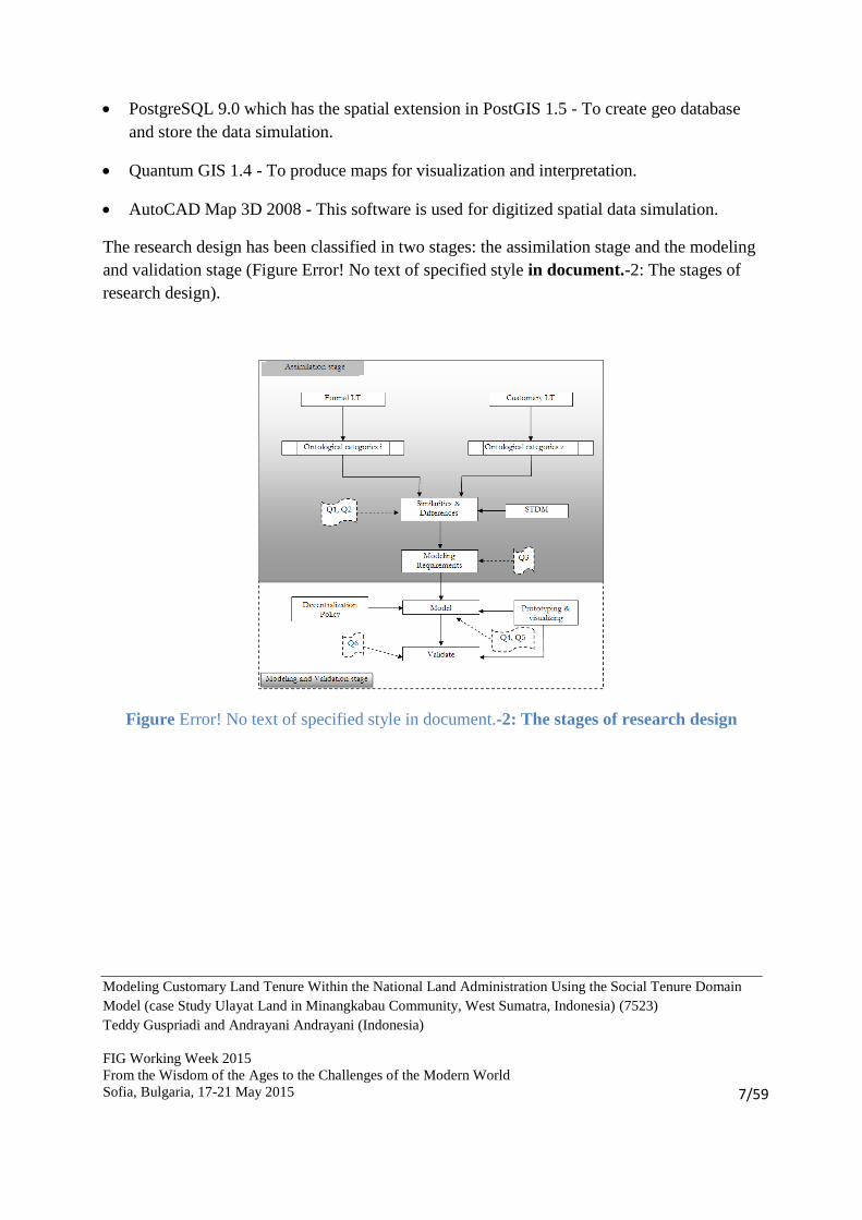
The research design has been classified in two stages: the assimilation stage and the modeling
and validation stage (Figure Error! No text of specified style in document.-2: The stages of
research design).
Figure Error! No text of specified style in document.-2: The stages of research design

Modeling Customary Land Tenure Within the National Land Administration Using the Social Tenure Domain
Model (case Study Ulayat Land in Minangkabau Community, West Sumatra, Indonesia) (7523)
Teddy Guspriadi and Andrayani Andrayani (Indonesia)
FIG Working Week 2015
From the Wisdom of the Ages to the Challenges of the Modern World
Sofia, Bulgaria, 17-21 May 2015
8/59
2. THE REPRESENTATION OF REALITY IN LAND ADMINISTRATION
This paper describes the reality in land administration system, which is determined by the
activities related to cadaster and land registration, land law, and the actors involved in land
administration. This domain is a part of social reality.
This paper uses the theory of institutional reality from John Searle in order to develop
institutional facts actually exists in land administration domain.
The aim of r-ontology of institutional reality is to show how the institutional reality is
developed. While the aim of e-ontologies to conceptualize the land administration domain that
actually exists in reality.
This paper uses a concept of ontology in the context of conceptual model design and includes
not only physical ontology that can be described as the physical reality, but also social and
institutional ontology that can describe human activities and social arrangements.
2.1. Reality in Land Administration
This section explains the reality in land administration based on ontology of institutional
reality. The most important thing that should be captured is how to understand the interaction
of the land administration with its environment. In order to explain this interaction need to
develop ontology of institutional reality in land administration domain. Based on
characterization of ontology in the ontology of institutional reality in land registration is part
of reality.
2.2. Parcel
In land administration, parcel is basic unit of land ownership which is representing
institutional fact.
2.3. Right in Land Administration
According to Searle’s theory, the ownership of right is the institutional fact and the individual
rights are conventional powers assigned to the institutional fact. The institutional fact remains
unaffected even though no conventional power is assigned (Bittner, 2001).

Modeling Customary Land Tenure Within the National Land Administration Using the Social Tenure Domain
Model (case Study Ulayat Land in Minangkabau Community, West Sumatra, Indonesia) (7523)
Teddy Guspriadi and Andrayani Andrayani (Indonesia)
FIG Working Week 2015
From the Wisdom of the Ages to the Challenges of the Modern World
Sofia, Bulgaria, 17-21 May 2015
9/59
Ownership of land is complex proposition rights. The bundle of rights is common way to
explain the complexity of relationship between human beings and land. The bundle of stick is
very useful to explain that rights can be separated and reassembled. For each stick represents
an individual right which is a common analogy made for the bundle of rights. For each owner
possesses a set of sticks related directly to the land.
Rights relevant for land administration in the legal sense can be characterized by two basic
types of rights duty and power. Duties describe obligations between persons, whereas powers
define possibilities activities of sovereign individual.
The interest of the owner is enforced and protected by the state, and the legal system defines
general rules of person to acts based on their rights.
2.4. Ontological Categories of Phenomena in Land Administration
According to Searle’s theory, there are three ontological categories of phenomena, those are:
object (e.g. sentences, birth of certificates, pieces of land etc.), subject (e.g. Professors, wives,
chairmen, etc.), and event (e.g. weddings, wars, elections etc.) (Searle, 1995, p. 97). He holds
that the ontological categories of phenomena can be determined by status function.
Ontological categories in land administration are intended to see the phenomena in land
administration.
Bittner (2001) uses the ontological
categories in order to see one of the
reality in land administration which is
transfer of ownership. He categorizes
legal persons as the subjects of rights, in
which a specific person is the owner of
the parcel which has some right to
perform activities concerning the parcel.
He categorizes land parcels and the
system of documentation as the object.
He justifies that parcels are the object of
property rights whereas legal documents represent change in land administration, these are
status indicator. He classifies transfer of ownership as the events. The event is caused by an
activity of the subjects involved in the event. Figure 2-1 shows the ontological categories in
transfer of ownership.
Figure Error! No text of specified style in document.-1: Ontological categories phenomena in land administration
(source Bittner 2001)

Modeling Customary Land Tenure Within the National Land Administration Using the Social Tenure Domain
Model (case Study Ulayat Land in Minangkabau Community, West Sumatra, Indonesia) (7523)
Teddy Guspriadi and Andrayani Andrayani (Indonesia)
FIG Working Week 2015
From the Wisdom of the Ages to the Challenges of the Modern World
Sofia, Bulgaria, 17-21 May 2015
10/59
In the different way, Henssen (1995) look at the phenomena in land administration from the
core perspective. He also categorizes of phenomena in land administration particularly
cadaster and land registration into three categories, which are man, right (stewardship), and
parcel (see Figure 2-4). He explains the concept of land tenure can be defined as the "the act,
right, manner or term of holding a landed property" or as "the nature of legal estate in land". If
land tenure is related to the broad field of land use, it is more than the "man-land"
relationship.
In that connection, it can be defined as the institutionalized relationship of people involved in
the use of land and the distribution of its products (Henssen, 1995). However, this model
explains about objects and properties in the formal land administration systems.
Van der Molen et al.(2006) come up with the broader concept of land administration systems
in which these systems reflect in principle the social relationship between people concerning
land, as they are recognized by a community or a state. This concept is in line with the
objectives of this paper in terms of concept the social relationship between people and land.
Properties of object in land administration systems have a social and legal meaning, and are
based on accepted social concepts. That concern about owners, rights and land, no matter
whether these concepts are laid down in the statutory or customary systems.
Based on three concepts of phenomena in land administration above, in principle there is one
category which different. Event, rights, and social tenure relationship are realities that should
be recorded in a specific manner, in this study all of them dealing with administrative.
Figure Error! No text of specified style in document.-3: Phenomena in formal land
administration (Henssen, 1995)

Modeling Customary Land Tenure Within the National Land Administration Using the Social Tenure Domain
Model (case Study Ulayat Land in Minangkabau Community, West Sumatra, Indonesia) (7523)
Teddy Guspriadi and Andrayani Andrayani (Indonesia)
FIG Working Week 2015
From the Wisdom of the Ages to the Challenges of the Modern World
Sofia, Bulgaria, 17-21 May 2015
11/59
3. SOCIAL TENURE DOMAIN MODEL
3.1. Alternative Land Administration Tools in Recognizing Customary Lands
Modeling the relationship between people and land as a basis for land administration system
is complex task (Lemmen, et al., 2007). Conventional land administration system is not
sufficient to support the complexity of customary systems. The need to find an alternative
land administration tools to recognize customary land become an important issue to guarantee
that the local community are not marginalized on their own land or to avoid that local
community are overruled by facts provided from formal (statutory systems).
The acknowledgement of customary land tenures into national land administration system
becomes an important issue to provide tenure security for customary community. By having
tenure security the customary community can take advantages from the productivity of their
lands and a proper compensation if their lands are used by third party. There is a need land
administration tool that has capability to accommodate customary tenure into national system.
As an alternative land administration tool, the Social Tenure Domain Model (STDM) is a pro-
poor land administration tool that can be used as an option.
3.2. UML for Land Administration Systems
Unlike many other geographic information systems, which provide information about
geographical objects and their attributes, land administration systems reflect the social
relationship between people concerning land, as they are recognized by community or state
(van der Molen, et al., 2006). Therefore this system is not only concern about physical aspects
but also social and legal aspects.
UML is a modeling language that consists of several concepts and notations used at different
levels of abstraction throughout the system development and maintenance. The general goal
of UML is to capture reality in an ideal world and represent entire system clearly in a single
picture that all understand without confusion. This ideal is difficult to achieve, because a
system has many different aspects; functional (its static structure and dynamic interactions),
non-functional (timing requirements, reliability, deployment, and so on), along with
organizational aspects (work organization mapping to code, and so on). A system description
requires a number of views, where each view represent a projection of the complete system
that show particular aspect (Eriksson et al., 2004).
The Object Management Group (OMG) has established standards for Model Driven
Architecture (MDA). The MDA provides a means for using models to direct the course of

Modeling Customary Land Tenure Within the National Land Administration Using the Social Tenure Domain
Model (case Study Ulayat Land in Minangkabau Community, West Sumatra, Indonesia) (7523)
Teddy Guspriadi and Andrayani Andrayani (Indonesia)
FIG Working Week 2015
From the Wisdom of the Ages to the Challenges of the Modern World
Sofia, Bulgaria, 17-21 May 2015
12/59
understanding , design, construction, deployment, operation, maintenance and modification
(OMG, 2003). Within MDA the system development process is determined by modeling
activity. The development system begins with the analysis requirements, mostly in text. Based
on these requirements, the artifacts (use cases, class diagram, and other UML models) are
created. The artifacts are collection of concepts and notations (model) that can be understood
by human and machine. There are two models within MDA. The first model is Platform
Independent Model (PIM). This model is an abstraction of real world and independent of any
implementation technology. The second model is Platform Specific Model (PSM). This model
is a view of system from the specific implementation technology such as PosgreSQL, Java
etc. In the implementation, these models are used to transform from model to code.
3.3. The Social Tenure Domain Model (STDM)
The Social Tenure Domain Model (STDM) is an initiative of UN-HABITAT to support pro-
poor land administration (UN-HABITAT, 2009). STDM is meant specifically for developing
countries, countries with very little cadastral coverage in urban or rural areas. It is also meant
for post conflict areas, areas with large scale informal settlements, or large scale customary
areas. The focus of STDM has been on all relationships between people and land,
independently from the level of formalization, or legality of those relationships (ISO TC 211,
2010). STDM contains the functionality of LADM, but under different terminology. Formal
terminology as used in LADM may not always be applicable because of the informal
environment (ISO TC 211, 2010).
The social tenure domain model is a UML diagram which presenting the object classes and
the relationship among them. All the object classes and their relationships are manifest of
domain ontology in land administration. All together provide an abstract conceptual
framework in land tenure system whether formal, customary, informal etc.
The Social Tenure Domain Model (STDM) is described with a UML class diagram. The core
classes of the STDM are Party, Spatial Unit, and the Social Tenure Relationship to this spatial
unit, which this party is involved in. These classes represent phenomena in land
administration, in which in each core class represents ontological category. The Class Party
represents subject of land right, the class spatial unit represents object of land right and the
class social tenure relationship represents land right and imply event inside this class.
The STDM consists of three packages (party package, administrative package and spatial unit
package) and one sub package (surveying and representation sub package). These packages
expended from the core classes of STDM. The surveying and representation is a sub package

Modeling Customary Land Tenure Within the National Land Administration Using the Social Tenure Domain
Model (case Study Ulayat Land in Minangkabau Community, West Sumatra, Indonesia) (7523)
Teddy Guspriadi and Andrayani Andrayani (Indonesia)
FIG Working Week 2015
From the Wisdom of the Ages to the Challenges of the Modern World
Sofia, Bulgaria, 17-21 May 2015
13/59
of the spatial unit package. The main class of each package has one mother class which is
versioned object. Class versioned object enables to manage and maintain historical data in the
database.
In Figure 3-7, an overview is presented on the main ontological categories in land
administration. This terms the following relations with the package in STDM.
Figure Error! No text of specified style in document.-4: The overview of ontological categories in the STDM

Modeling Customary Land Tenure Within the National Land Administration Using the Social Tenure Domain
Model (case Study Ulayat Land in Minangkabau Community, West Sumatra, Indonesia) (7523)
Teddy Guspriadi and Andrayani Andrayani (Indonesia)
FIG Working Week 2015
From the Wisdom of the Ages to the Challenges of the Modern World
Sofia, Bulgaria, 17-21 May 2015
14/59
4. INDONESIAN LAND ADMINISTRATION SYSTEM AND CUSTOMARY
TENURE SYSTEM IN MINANGKABAU COMMUNITY
4.1. National Indonesian Land Administration System
The legislative in Indonesian government system is arranged in a hierarchy, as in the Act of
the People’s Consultative Assembly No.3/ 2000. On this hierarchy of legal provisions only 7
types of ranked legal products are mentioned: (1.) the constitution (UUD 45), (2.) acts of the
People’s Consultative Assembly (TAP MPR), (3.) laws (Undang-Undang), (4.) government
regulations substituting laws (Peraturan Pemerintah Pengganti Undang-undang), (5.)
government regulations, (6.) presidential decrees and (7.) regional/local regulations
(Peraturan Daerah).
Based on the Indonesian constitution of 1945, Indonesia enacted The Basic Agrarian Law of
1960 (BAL) on September 24, 1960 as a foundation for national agrarian law. The main
concerns to the establishment of BAL are:
1. To lay the basic foundation of a national land law formulation for justice, prosperity and
welfare of the people.
2. To lay the basic foundation to unify and simplify the land law.
3. To lay the basic foundation to provide land right security for all people.
BAL also creates unification in agrarian law that can be seen from its principles; those are
nationalism (non Indonesians are excluded from land rights), socialism (all Indonesians shall
have access to minimum of land), Indonesianism (land law based on traditional, customary
law: Adat).
The government regulation Number 24 (1997) is about the Indonesian land registration
system. It provides the basic principles of land registration which are simple, secure,
affordable, up-to-date and open. This regulation is mentioning that land registration aiming on
(i) ensuring tenure security to the land right holder, (ii) providing information to the
stakeholders, (iii) establishing good land administration (Presiden Republik Indonesia, 1997).
The regulation mandates BPN as the only one government institution which conduct
Indonesian land registration. Furthermore, BPN is assisted by Pejabat Pembuat Akta Tanah
(PPAT). Usually, the PPAT is a notary or a head of sub-district in particular area which is
pointed by BPN. The PPAT assist BPN in terms of providing all kinds of deeds, such as
transfer deed, mortgage deed etc.
The Ministry of Agrarian/ Head of National Land Agency Regulation Number 3/1997 is a
provision to implement government regulation number 24/1997. It regulates procedures and

Modeling Customary Land Tenure Within the National Land Administration Using the Social Tenure Domain
Model (case Study Ulayat Land in Minangkabau Community, West Sumatra, Indonesia) (7523)
Teddy Guspriadi and Andrayani Andrayani (Indonesia)
FIG Working Week 2015
From the Wisdom of the Ages to the Challenges of the Modern World
Sofia, Bulgaria, 17-21 May 2015
15/59
mechanisms of Indonesian land registration system, which consist of the surveying and
mapping, the initial registration and the data maintenance (Menteri Negara Agraria/ Kepala
Badan Pertanahan Nasional, 1997).
State through the constitution obtains a right to control land resources within the country. As
mentioned in article 33 of Indonesian constitution (1945) that the entire earth, water, and air
space are controlled by the state. It means that the right of the state to control land resources is
the highest level of right. From the perspective of nation this right has the public aspect.
According to the article 2 BAL (1960) this right gives the authority for the state to regulate
and implement, the utilization, the reservation and the cultivation of the land resources; to
determine and regulate the legal relation between persons and land resources; to determine
and regulate the legal relations between persons and legal acts concerned with land resources.
4.2. Customary Tenure System in Minangkabau Community
The term of ulayat for the first time is used by minangkabau community to define their
territory. Van Vollenhoven in his book “Miskenningen Van Het Adatsrech” characterizes the
ulayat land tenure system into five, those are:
1. Parties that can exploit forest (virgin lands) in their territory are only the people from their
own community. They may use only for their own family. If they use for sale then they
should pay for that (bungo). They can open forest for agriculture, construct the small
village, and gathering forest products.
2. The outsiders only may use customary land as long as they get permision from the leader
of community. They have to pay retribution (recognitie) for the adat community.
3. The adat community still has rights to control cultivated lands.
4. The adat community has responsibility in terms of unaccountable action within the area.
5. Ulayat rights cannot be transferred permanently.
According to regulation of Agrarian Ministry no. 5 (1999), ulayat right is an authority which
is owned by an adat community in particular region where its community’s members live and
take advantage of natural resources on it. This includes land in this region for livelihood of
community’s members, which occur in a way outwardly and inwardly from heritage without
disconnected between its community and its region. Definition of ulayat land is a piece of
land which has ulayat land on it. Based on these definitions, it can be concluded that ulayat
right is accumulation of characteristics of ulayat right which is mentioned above. In

Modeling Customary Land Tenure Within the National Land Administration Using the Social Tenure Domain
Model (case Study Ulayat Land in Minangkabau Community, West Sumatra, Indonesia) (7523)
Teddy Guspriadi and Andrayani Andrayani (Indonesia)
FIG Working Week 2015
From the Wisdom of the Ages to the Challenges of the Modern World
Sofia, Bulgaria, 17-21 May 2015
16/59
minangkabau region, the highest level of ulayat right is managed by Nagari (adat village
authority).
According to regional regulation of West Sumatra no 2 (2007), Nagari is a unit of adat
community which has the particular territorial boundaries and the authority to manage and
take care of local community interest based on adat in minangkabau community (Gubernur
Sumatera Barat, 2007).
Adat in minangkabau community regulates and manages the living system of people within
Nagari. The Nagari is formed by the process of forest clearing with temporary settlements
(taratak), to hamlet (kampuang), to combinations of hamlet (koto), and finally Nagari. Nagari
is a unit of the customary community in the West Sumatra province, which contents of clans
(suku); it has territory with the particular boundaries.
Concepts of territory in adat are important to determine the boundaries of Nagari. Nagari’s
territory is determined by the region that holds by member of community (Anak Nagari). All
lands and forests areas that are hold by all members of the community are territories of
Nagari. The forest areas which are using as shifting area, such a temporary settlements, or
hamlet, is one of indicator to
determine territory of Nagari.
Besides factual evidence, the
territorial Nagari also rests on the
histories (tambo), which are
describing the boundaries. Another
way to determine the territory of
Nagari is recognizing of boundaries
from the adjacent of Nagari
(Contradictory delimitation). Based
on the explanations above, it can be
concluded that territory of Nagari is
the entire earth surface till the
territory of Nagari adjacent. It is
means that there is no land without
holder. In other words, there is no state land or forest state along the territory of Nagari.
Figure Error! No text of specified style in document.-5:
Structure of the extended family in minangkabau
community (adopted from H.D.Evers, 1975)

Modeling Customary Land Tenure Within the National Land Administration Using the Social Tenure Domain
Model (case Study Ulayat Land in Minangkabau Community, West Sumatra, Indonesia) (7523)
Teddy Guspriadi and Andrayani Andrayani (Indonesia)
FIG Working Week 2015
From the Wisdom of the Ages to the Challenges of the Modern World
Sofia, Bulgaria, 17-21 May 2015
17/59
In minangkabau community, each member of community in Nagari (Anak Nagari) is the
subject of land resources in Nagari. As the ownership and land holder system according to
adat is communal, it is important to understand the structure of society in minangkabau
community. Subjects of rights in adat system are determined and arranged in layers, for
example individual and collective member of adat community in Nagari, see further Error!
Reference source not found. and Figure 4-1:
According to Warman (2009) the structure of society in Nagari begins from the extended
family or major linage (kaum) as shown in the diagram above. A kaum can have large number
of members, and it may split into some minor lineages (paruik). Paruik consists of some
households which have a kitchen (tungku) to share. A kitchen is developed by the women
after they are married. A small household consists of all persons (children) from a single
mother (sainduak). It can be concluded that each Anak Nagari is also a member of small
household (sainduak). In other word, a Nagari is aggregated of some kaum, while kaum is
aggregated of some paruik, and paruik is aggregated of some sainduak as depicted in Figure
4-2.
The specific character of the management
of ulayat land in minangkabau is its
inheritance system. Those are high
inheritance (harta pusako tinggi) and low
inheritance (harta pusako rendah). High
inheritance represents the property of a
lineage to which a household only has user
rights, it is not allowed to sale. It is
inherited from the ancestors and includes
rice fields and the house. It is traced down
from the mother to her daughters, whereas
men may not inherit any of it. Low
inheritance represents individual property,
which is obtained from the household
earnings or buys by a person before
married. Land clearing in primary forest
and bought land also include under this
category. It is shared equally between
daughters and sons.
Figure Error! No text of specified style in document.-6: Visualization of structure boundaries within a Nagari
Modeling Customary Land Tenure Within the National Land Administration Using the Social Tenure Domain
Model (case Study Ulayat Land in Minangkabau Community, West Sumatra, Indonesia) (7523)
Teddy Guspriadi and Andrayani Andrayani (Indonesia)
FIG Working Week 2015
From the Wisdom of the Ages to the Challenges of the Modern World
Sofia, Bulgaria, 17-21 May 2015
18/59
Based on the explanations above, it can be concluded that customary land which exists in
minangkabau community is divided into two categories:
1. Communal land which is held by each community. It is named ancestral land (tanah
pusako).
2. Individual land which is obtained from the small household earning or land clearing of
primary forest in the Nagari. Someone allows opening Nagari’s forest after he/she gets
permission from the authority of Nagari.
According to Evers (1975) there are three basic types of land tenure in minangkabau
community based on land holders:
- Land held by individuals under individual ownership rights
- Land held by descent groups of varying size and generational depth under communal
ownership rights.
- Land held by local groups, namely village (Nagari) communities.
4.3. The Position of Ulayat Rights in Indonesian Land Administration System
According to Warman (2009) legal certainty is given only by the state through the statutory
tenure system which is vulnerable and unable to exist when the state is in a condition of
instability. This condition generates many reclaiming actions at the beginning of reformation
(post Suharto regimes). Furthermore the fact shows as if the customary law supports these
actions. Even though, not necessarily these actions get support from adat. This condition will
never happen, if at the beginning adat is also involved in order to give legal certainty for all.
In other words, if the condition of the state is instable then adat through its institutions give
legal certainty for the interested parties to tackle the irresponsibility parties.
The decentralization policy gives opportunity to the local governments to develop responsive
policy for the adat that exists in each region by using statutory system as guidance. By using
this policy, each local government expected has capability to develop local policy that can
manage assimilation between statutory tenure system and customary tenure system. This
concept will support the principle of diversity in unity in terms of tenure arrangement.
Decentralization of land resources in the implementation depends on the political will of
central government and the integrity of all actors that involve. In one hand, decentralization
gives autonomy to the local governments, so that they have wider movement to actualize their

Modeling Customary Land Tenure Within the National Land Administration Using the Social Tenure Domain
Model (case Study Ulayat Land in Minangkabau Community, West Sumatra, Indonesia) (7523)
Teddy Guspriadi and Andrayani Andrayani (Indonesia)
FIG Working Week 2015
From the Wisdom of the Ages to the Challenges of the Modern World
Sofia, Bulgaria, 17-21 May 2015
19/59
authorities. In other hand, decentralization also creates the excessive euphoria, so that they
fell no need to do coordination with the central government (Warman, 2009 as he cited from
Utomo, 2003). Therefore, in order to avoid conflicts of interest in decentralization the process
needs intensive communication between local components and the central government.
The question arises about how to implement autonomy in the lowest level of government such
as village government. Whether placing adat institution as a part of the governmental system
has guaranteed rights to its community? The answer is that this cannot be sure, at least it can
be seen from the Malaysia experience in the state of Sarawak. Whereas most of the chiefs and
customary institutions tend to be businessman agents to exploit natural resources, so that
ignoring rights of its community. As its results create the illegitimate customary institutions as
the competitors the original customary institutions (ICRAF, 2003).
Learning by Sarawak’s experience, provincial government of West Sumatra did not create the
customary institutions automatically as a part of government system, but creates government
institutions which legitimate in customary community. Therefore, a Nagari as the lowest level
government should have acknowledgment from its community. A leader of Nagari (Wali
Nagari) is a member of its community who is selected by all members of community in
Nagari through general election. Beside, Wali Nagari as the executive there are two
components of Nagari that should be involved in terms of Nagari’s government system,
which are the Parley of Nagari (Badan Permusyawaratan Nagari –BAMUS) as the legislative
and Adat Nagari Assembly (Kerapatan Adat Nagari –KAN) as judicative. In other words, the
Nagari’s government system is an adoption of modern government systems, wherein for each
Nagari has components of modern government system. This concept is really touching local
community interest and deals with democracy and good governance.
Decentralization of land resources has long story. It has started from BAL, wherein contents
and the explanations of BAL itself are centralistic. Even though, in implicit it gives
opportunity for decentralization. According to article 2 verse (4) BAL (1960) mentioned that
implementation of right of the state to control land resources can be transferred to the
autonomous regions and to the customary communities. In article 3 BAL (1960) declared that
the state recognize ulayat right even though with some requirements. In article 5 BAL (1960)
also declared that Agrarian law which applicable for agrarian resources arrangement is adat
law. It is clear that BAL itself allows decentralization management of agrarian resources
particularly land resources.
Modeling Customary Land Tenure Within the National Land Administration Using the Social Tenure Domain
Model (case Study Ulayat Land in Minangkabau Community, West Sumatra, Indonesia) (7523)
Teddy Guspriadi and Andrayani Andrayani (Indonesia)
FIG Working Week 2015
From the Wisdom of the Ages to the Challenges of the Modern World
Sofia, Bulgaria, 17-21 May 2015
20/59
In land management, generally there are three aspects as the scope of management:
1. Planning aspect, i.e. arrangement about planning, use or utilization and maintenance of
land.
2. Properties aspects, i.e. arrangement and determination legal relationship between people
and land.
3. Transfer aspects, i.e. arrangement about legal activities and legal events in terms of transfer
of rights.
In BAL, these aspects include in a packed is named “Right of the state to control the land
resources” (Hak Menguasai dari Negara in short HMN), wherein principle this right belongs
to the state.
This right still leaves some implementation problems in terms of decentralization policy. In
fact, planning aspect and legal activities aspect in land management can be transferred to local
government even to Nagari. It is possible as long as there is good coordination and
communication between the government institutions involved. Whereas determination land
rights is difficult to be implemented. A person is not allow to create new land rights for
himself/herself except rights mentioned in law (Warman, 2009 as he cited from Abdulkadir
Muhammad, 1990). Therefore, in BAL there is an article which determines land rights; this is
a closed system of land right (article 16 BAL). The problem is implementation concept of
centralistic in BAL is not fit with decentralization of government system policy. In local level
even in Nagari, there is asynchronous between BAL and decentralization policy, which
creates difficulties to formulate compatible decision. If the type of land rights in BAL is
compatible with the type of land rights according to adat, then there is no problem.
Type of land rights is the dominant issue in order to formalize customary rights. There are big
differences between type of land rights in BAL and type of land rights according to adat. In
adat principle there are two kinds of land rights; those are the right of ownership and the right
to use. Whereas in BAL there are two kinds of rights that have no equivalence in adat; those
are Hak Guna Usaha and Hak Guna Bangunan. This is because of the formulation of the
BAL is not only according to adat law but also influenced by the western law. On other hand,
these differences are becoming threats in implementation, for example Hak Guna Usaha.
According to BAL this right is given on the state land and could not be on the ulayat land.
Even though many Hak Guna Usaha are given on the ulayat land, wherein adat community is
understood as right to use. In understanding of the local people the right to use is a temporary
right. If its duration is over or the land is abandoned by the right holder, then adat community
assume that this land returns back to the ulayat land. Whereas according to BAL this land
becoming the state land.

Modeling Customary Land Tenure Within the National Land Administration Using the Social Tenure Domain
Model (case Study Ulayat Land in Minangkabau Community, West Sumatra, Indonesia) (7523)
Teddy Guspriadi and Andrayani Andrayani (Indonesia)
FIG Working Week 2015
From the Wisdom of the Ages to the Challenges of the Modern World
Sofia, Bulgaria, 17-21 May 2015
21/59
Post new order regime since 1998, the Indonesian government has produced some
decentralization policies through laws and government regulations. Law no.22 year (1999)
substituted in law no 32 year (2004) is an umbrella act in terms of the decentralization of
government system. In line with this law, the government has sought to reform agrarian law,
especially land law, through the spirit of decentralization and local autonomous law. Agrarian
reform should start from BAL as the umbrella act in terms of management of agrarian
resources. Therefore the President Republic of Indonesia issue decrees no.34 year (2003)
about national policy in land affairs. This decree is one of the government efforts to revise
BAL, in order to accommodate requirements of communities’ in autonomous environment. In
order to revise and synchronize BAL with other law and norms of societies should involve
many departments and actors, such as forestry department, mining department, marine
department and also civil society.
The regional government of West Sumatra takes this opportunity by producing policies to
establish a form of the village government underneath sub-district (Kecamatan) is Nagari.
This policy gives positive impacts in terms of land resources management in Nagari. Nagari
has the role as the administrative government and also adat administrative. Local government
could be more aspirated to taking into account the existence of norms in its community and
keeping reference to higher levels of law. Nagari as the village government and also adat
government have a role in terms of revitalize ulayat land in its region. By implementing this
policy is expected to bring reinforcement of ulayat land. This policy also unifies the entities
of adat community. In the past, management of ulayat land is arranged by adat institutions
and separated from government administrative. Nowadays, the implementation of Nagari
government system supports the existence of ulayat rights. By integrating Nagari into the
government system, automatically adat institutions take a role in government system. The
regional government quite responsive to accommodate adat institutions that can be took role
in government system, wherein these institutions should have legitimacy by all components in
Nagari. Legitimacy government of Nagari as represent of adat community will reinforce
ulayat land.
According to Warman (2009) the reinforcement of a right is determined by the three factors,
those are (1) reinforcement of subject, (2) reinforcement of object and (3) reinforcement of
authorities of the subject to object according to law. The question arises how to determine the
existence of ulayat right. According to the regulation of Ministry of Agrarian/Head of NLA
no 5 (1999) the existence of ulayat right is determined by three requirements, those are: (1)
the existence of people as subjects of right, (2) the existence of land and other natural
resources which stick to its land as object of ulayat right, (3) The existence of obvious
authorities of subjects to manage and to use its land (Menteri Negara Agraria/ Kepala Badan
Pertanahan Nasional, 1999).

Modeling Customary Land Tenure Within the National Land Administration Using the Social Tenure Domain
Model (case Study Ulayat Land in Minangkabau Community, West Sumatra, Indonesia) (7523)
Teddy Guspriadi and Andrayani Andrayani (Indonesia)
FIG Working Week 2015
From the Wisdom of the Ages to the Challenges of the Modern World
Sofia, Bulgaria, 17-21 May 2015
22/59
Acknowledgement of ulayat Nagari is one of consequence from recognition of Nagari as the
lowest level of government system. Because of a Nagari as a unit of customary community is
not only consists of Nagari’s governments but also all members of community and their
territorial as the place for their live and their livelihood. The reinforcement of ulayat Nagari
gives opportunity for Nagari to manage all Nagari’s properties. All Nagari’s properties,
which are managed by the state and/or private companies based on one of right in BAL such
as right to cultivate land and/or right of use, if the duration of its right is over, then those
properties return back to Nagari as Nagari’s properties. It is means that ulayat land which is
held by private company, if the duration is over then its land should returned to Nagari. Even
though in law, if its right expire then its land automatically becoming the state land then local
government should returned back this land to Nagari by using applicable law.

Modeling Customary Land Tenure Within the National Land Administration Using the Social Tenure Domain
Model (case Study Ulayat Land in Minangkabau Community, West Sumatra, Indonesia) (7523)
Teddy Guspriadi and Andrayani Andrayani (Indonesia)
FIG Working Week 2015
From the Wisdom of the Ages to the Challenges of the Modern World
Sofia, Bulgaria, 17-21 May 2015
23/59
5. MODEL REQUIREMENTS ANALYSIS
5.1. Model Requirements Indonesian National Land Administration System
Indonesian national land administration system arranged based on laws and regulations. The
data model requirements rest on the government regulation number 24 (1997) and regulation
of Ministry of Agrarian/ Head of BPN number 3 (1997). This data consist of textual data and
spatial data. Textual data consists of all information about subjects of the land rights, object of
the land rights, and the relationship between subjects and objects (right, restriction,
responsibility, and event which create this relationship). The spatial data consists of geometric
data that represents the spatial unit or object of land right. The properties of model are
initiated by analysis of model requirements. Analysis of model requirements is important part
in order to develop a proper model. However, the model requirements have to be in line with
of the purpose system. The model requirements can be seen in the sub-sections below.
5.1.1. Person
In the Indonesian NLAS, there are two main types of person; those are the real person, and the
juridical person. A person registered in this system when it owns a piece of land based on a
right. The histories of ownership should be handled in the database. Therefore, a person
cannot be removed in the system even though the right has transferred to another person. A
person in land administration is a temporal object and its lifespan is defined based on person
type.
1. Natural Person
This person represents a real man or woman. She/he can still exist in the database system
after his/her death. In the existing system, the real person has the following attributes:
person_Id: this attribute is identifier number of person.
name: The name of person is an attribute to put the sure name of a person.
birth place: The name of the place where a person was born.
birth date: The date of birth of a person.
gender: the gender of a person.

Modeling Customary Land Tenure Within the National Land Administration Using the Social Tenure Domain
Model (case Study Ulayat Land in Minangkabau Community, West Sumatra, Indonesia) (7523)
Teddy Guspriadi and Andrayani Andrayani (Indonesia)
FIG Working Week 2015
From the Wisdom of the Ages to the Challenges of the Modern World
Sofia, Bulgaria, 17-21 May 2015
24/59
2. Juridical person
In Indonesian NLAS, all kinds of institutions, organizations, foundations such as, private
company, government institution, etc. are registered as a juridical person. Juridical person
may have member, which identified as a constituent of a group person. The juridical
person has following specific attributes:
juridical_Id: this attribute is identifier number juridical person
type: This attribute describes typology of juridical person. For example: Private
company, government organization etc.
5.1.2. Register Parcel
Register parcel in Indonesian NLAS consists of parcel, administrative, and land use. Forest
area excluded from domain of register parcel.
1. Parcel
Parcel is a basic unit in land administration which shows the boundaries of the land
ownership. All data in cadastre and land registry are compiled on its. Subjects and events
in a land administration system have relationships with land parcel. All types of
information on parcel may change by the time, such as parcel value, land use, etc. Even,
land parcel itself may change because of sub division and amalgamation. The system has
to be handled to keep the histories of land parcel. A land parcel has spatial temporal
attributes whereas temporal attributes may change over the time. A Parcel in Indonesian
NLAS consists of the following attributes:
Parcel identifier (Nomor identifikasi bidang in short NIB): Each parcel must have a
unique parcel identifier which can be defined as composite attribute and decomposed
into, There is an exception of parcel identifier system for land parcel which is owned
by HGU or HPL. For both of these rights, district level is used as lowest spatial unit
level by using 0000 as Id code. For example: the parcel identifier number
‘03130000.00001’ was assigned to parcel number ‘00001’ in Padang Pariaman
district.
Parcel area: This attribute can be legal area and/or computed area. Legal area is issued
to the public as in legal document, whereas computed area is derived from the
coordinate of boundary nodes. It cannot be determined if there is vagueness about

Modeling Customary Land Tenure Within the National Land Administration Using the Social Tenure Domain
Model (case Study Ulayat Land in Minangkabau Community, West Sumatra, Indonesia) (7523)
Teddy Guspriadi and Andrayani Andrayani (Indonesia)
FIG Working Week 2015
From the Wisdom of the Ages to the Challenges of the Modern World
Sofia, Bulgaria, 17-21 May 2015
25/59
boundary marks. For example, if there is no agreement about the borders between
neighboring parcel owners, or there is lawsuit about boundary wherein the whole or
partial boundary cannot be defined until the lawsuit ends.
Geometric: A land parcel has a two dimensional closed polygon shape in cadastral
maps. Nodes in polygon define with (X, Y) coordinates series and the lines connect
these nodes.
2. Spatial Administrative Level
Spatial administrative level in Indonesian NLAS is related with the structure of administrative
government system, from the highest level till the lowest level, wherein a parcel is located in
a spatial administrative. A spatial administrative level has following structures:
a. Province (Provinsi)
A province is the highest level of spatial administrative unit which formed by several
districts. It is a spatial object, wherein boundaries of province are defined for
administrative purposes. Province should be defined as spatial temporal database because a
province may also change over the time. For example, sub division of a province creates a
new province or some of its districts separate to constitute a new province. A province has
following attributes:
Province code: It is defined by the province’s national code number (two digits). For
example, it is ‘03’ for West Sumatra province.
Name: Name of the province
Geometric: A province has a two dimensional polygon shape which is defined by the
nodes, and the nodes are connected by the lines. Its boundaries can change over the
time.
b. District (Kabupaten/Kota)
A district is spatial administrative unit underneath of a province which has several sub
districts, wherein a district is located in a province. It is a spatial object wherein its
boundaries are defined for administrative purposes. District should be defined as spatial
temporal database because a district may also change over the time. For example, a new
sub district can be added to a district. A district has following attributes:
District code: It is uniquely identified in Indonesia. The district code has four digits
number wherein the province code number that district belongs to was used as prefix.

Modeling Customary Land Tenure Within the National Land Administration Using the Social Tenure Domain
Model (case Study Ulayat Land in Minangkabau Community, West Sumatra, Indonesia) (7523)
Teddy Guspriadi and Andrayani Andrayani (Indonesia)
FIG Working Week 2015
From the Wisdom of the Ages to the Challenges of the Modern World
Sofia, Bulgaria, 17-21 May 2015
26/59
For example, the code district ‘0313’ was assigned to Padang-Pariaman district, wherein
‘03’ represents West Sumatra province and ‘13’ represents Padang Pariaman district.
Name: Represent the district name, wherein can be changed with the state’s decision.
Geometric: A district has a two dimensional polygon shape which is defined by the
nodes, and the nodes are connected by the lines. Polygon of a district inside the polygon
of its province. It boundaries can change over the time.
c. Sub-district (Kecamatan)
A sub-district is the spatial administrative unit underneath district which has some villages.
It is a spatial unit wherein its boundaries are defined for administrative purposes. Sub-
district should be defined as spatial temporal database because a district may change over
the time. For example, a large sub-district can be divided into two or three sub-district by
decision of mayor of district. A sub-district has following attributes:
Sub-district code: It is a unique number which define a particular sub-district. This code
is defined by adding the corresponding district code to the sub-district code number that
is orderly given in the district. For example, the code sub-district ‘031311’ was assigned
to Ulakan Tapakis sub-district, wherein ‘0313’ represents Padang Pariaman district and
‘11’ represents Ulakan Tapakis sub district.
Name: Represents the sub-district name. This attribute information can be changed
without any change on its geometric.
Geometric: A sub-district also has a two dimensional polygon shape which is defined by
the nodes, and the nodes are connected by the lines. Polygon of a sub-district inside the
polygon of particular district. It boundaries can change over the time.
d. Village (Desa/Kelurahan)
A Village is the smallest spatial administrative unit. It is a spatial unit wherein its
boundaries are defined for administrative purposes. The boundaries may change over the
time. Therefore it is defined as spatial temporal database. A village may be divided into
some villages or merger with one or more villages.
3. Land use
The land use characterize into agriculture and non-agriculture. It can change over the time.
For example, an agriculture land can be converted into non agriculture land based on the land
use change permission (Ijin Perubahan Penggunaan Tanah –IPPT). Land use has following
attributes:

Modeling Customary Land Tenure Within the National Land Administration Using the Social Tenure Domain
Model (case Study Ulayat Land in Minangkabau Community, West Sumatra, Indonesia) (7523)
Teddy Guspriadi and Andrayani Andrayani (Indonesia)
FIG Working Week 2015
From the Wisdom of the Ages to the Challenges of the Modern World
Sofia, Bulgaria, 17-21 May 2015
27/59
Land use type: It is an attribute that describe land use of a parcel. There are two land use
types; those are agriculture and non-agriculture.
Geometric: A land use has a two dimensional polygon shape which is defined by the
nodes, and the nodes are connected by the lines. This polygon can across administrative
polygon. Information in this attribute is temporal. It can change over the time.
5.1.3. Right
The existing relationship between person and land in the Indonesian NLAS is statutory rights.
This relationship is temporal and the form can be right, restriction, and responsibility.
1. Right
A Parcel can be owned by one person or more based on a right, whether juridical person
or real person. Single person may own many parcels. The relationship between person
and parcel based on the rights has following attributes:
Right type (Jenis hak): It is an attribute which determine type of relationship between
person and particular land. There are many types of right that can be put into this
attribute such as HM, HGU, HGB, HP etc. Type of right is determined by the purpose
of its land and reference document as an evidence of the land granted to the person.
Right code (Kode Hak): It is an attribute to identify type of rights. This code only one
digit, wherein the sequences of right consists of ‘1’ for right of ownership, ‘2’ for right
to cultivate, ‘3’ to for right to construct building, ‘4’ right of use, ‘5’ right of
management, ‘6’ right of waqf, and ‘7’ right of apartment.
Right Number (Nomor Hak): Each right must have a unique right identifier which can
be defined as composite attribute and decomposed into, (i) five digits parcel number
(identification number of a right that is uniquely defined per type of right in a village),
(ii) one digit number type right code (identification number of a type of right), (iii)
eight digits village code (identification code of village. For example: the right number
‘03131101.1.00570’ was assigned to right of ownership number ‘00570’ Tapakis
village, wherein ‘03131101’ represents Tapakis village, ‘1’ represents right code of
ownership, and ‘00570’ represents right number. This administrative system is
implemented for all type rights except right to use and right of management. For both
of these rights, district level is used as lowest spatial unit level by using 0000 as Id
code. For example: the right number ‘03130000.2.00001’ was assigned to right to
cultivate number ‘00001’ Padang Pariaman district.

Modeling Customary Land Tenure Within the National Land Administration Using the Social Tenure Domain
Model (case Study Ulayat Land in Minangkabau Community, West Sumatra, Indonesia) (7523)
Teddy Guspriadi and Andrayani Andrayani (Indonesia)
FIG Working Week 2015
From the Wisdom of the Ages to the Challenges of the Modern World
Sofia, Bulgaria, 17-21 May 2015
28/59
Validity period: Temporary rights have validity period, such as HGU, HGB, and HP.
The start date and end date should be held in a database system. Only HM has no end
date information.
2. Restriction
The restriction in NLAS in terms of the relationship between people and land is designed
to regulate person activities on its land. It can be relate with natural protection and legal
action on its land. For example: There is no individual right allowed in forest which was
determined protected area. Restriction has following attributes:
Restriction name: It is an attribute that describes restriction on land. It can be name of
an area protection, zoning city planning, legal action (collateral, transfer) etc.
Validity period: This attribute describes start date and end date of restriction that stick
on its right.
Geometric: this attribute has a two dimensional polygon shape which is defined by the
nodes, and the nodes are connected by the lines. This polygon geometric can be across
the administrative polygon.
3. Responsibility
There is no specific attribute in NLAS describes responsibility in terms of relationship
between person to their land.
5.1.4. Analysis Requirements
Model requirements in Indonesian NLAS which explained in ontological categories above can
be analyzed from the purpose of model. The purpose of model is to establish spatial temporal
database in Indonesian NLAS, and touch upon legal, geographical and other aspects.
Considering those aspects, person as subject of right, register-parcel as object of right and
right itself can be specified and recorded in a database. Subsequently in context spatial, these
data can be extracted and shown in cadastral map. In the context temporal, information about
historical data should be handled in spatial database.

Modeling Customary Land Tenure Within the National Land Administration Using the Social Tenure Domain
Model (case Study Ulayat Land in Minangkabau Community, West Sumatra, Indonesia) (7523)
Teddy Guspriadi and Andrayani Andrayani (Indonesia)
FIG Working Week 2015
From the Wisdom of the Ages to the Challenges of the Modern World
Sofia, Bulgaria, 17-21 May 2015
29/59
5.2. Model Requirements Custommary Land Tenure System (Ulayat Land) Anak
Nagari
According to adat in minangkabau community, every anak nagari is the subject of ulayat
right. There are two types of anak nagari that can be subject of ulayat right which are person
and group person. A person can be in one or more groups. A group can be member of another
group.
1. Person
This person represents a real man or woman.
2. Group person
Group person represents community that can be Nagari, Suku, Kaum etc. Each group can
be represented by a leader on behalf its community or all persons in community. Group
person is a subclass of person, wherein the attributes group of person should be the same
with real person. The share information of each lineage member has to be explained in
the ulayat.
5.2.1. The Ulayat Land
According to adat, the ulayat Nagari is the highest level of the ulayat land. The ulayat nagari
is the whole lands within territorial of Nagari excluding individual and collective land (e.g.
ulayat kaum, ulayat suku). These lands belong to all the community within a customary
village (Nagari). The boundaries of the ulayat Nagari are fuzzy boundaries, whereas the
boundaries of the ulayat clan and the ulayat lineage are fixed boundaries.
1. Parcel
Parcel in ulayat land shows the boundaries of the land ownership in the format of
boundaries description. Furthermore it gives description about the names of the
neighborhood or the nature features along the boundaries based on the cardinal points
which are north, east, south, and west. The parcel boundaries clear in the field. There is
no identifier number of parcel in Nagari. Therefore, it will be necessary to establish
parcel identifier number.

Modeling Customary Land Tenure Within the National Land Administration Using the Social Tenure Domain
Model (case Study Ulayat Land in Minangkabau Community, West Sumatra, Indonesia) (7523)
Teddy Guspriadi and Andrayani Andrayani (Indonesia)
FIG Working Week 2015
From the Wisdom of the Ages to the Challenges of the Modern World
Sofia, Bulgaria, 17-21 May 2015
30/59
2. Nagari Unit
Nagari unit is related with the structure of administrative territory. The highest level of
administrative unit in minangkabau community is Nagari. A Nagari has a specific name
and description of territory. The lowest hierarchy in spatial Adat’s administrative unit is
Kampuang. A Kampuang has attributes name and description of territory. The boundaries
of Nagari units are fuzzy boundaries.
3. Land Use
The land use characterize into the forest land, the agriculture land and the settlement land.
It can change over the time. For example, a forest land can be converted into agriculture
land based on the Adat agreement.
5.2.2. The Ulayat Right
The characteristic of the ulayat right in minangkabau community is eternal, in which there is
no validity time. The ulayat land may use by Anak Nagari as long as they use for their
livelihood. The social tenure relationship between people and land can be described into right,
restriction, and responsibility.
1. Right
The basic foundation of the ulayat land is the ulayat Nagari, wherein ulayat Nagari is the
common land which owned by Anak Nagari. A person can be the owner of the ulayat land
based on the position of a person on particular community within a Nagari.
2. Restriction
The principle of communal land is not allowed to sale or diminished, but it can be leased
and mortgaged. Utilization of ulayat land by the outsider of community is based on the
principle beneficial mutually. The individual land right of the ulayat land in adat is only
temporary, and then at the end will be back as communal land. It is means that there is
validity period.
3. Responsibility
According to adat, every right which is given on the ulayat land attached responsibility to
protect preservation of its land based on the principle of sustainable environment.

Modeling Customary Land Tenure Within the National Land Administration Using the Social Tenure Domain
Model (case Study Ulayat Land in Minangkabau Community, West Sumatra, Indonesia) (7523)
Teddy Guspriadi and Andrayani Andrayani (Indonesia)
FIG Working Week 2015
From the Wisdom of the Ages to the Challenges of the Modern World
Sofia, Bulgaria, 17-21 May 2015
31/59
5.2.3. Analysis Requirements
Model requirements in ulayat land tenure system as explained in ontological categories above
have to be analyzed from the purpose of model. The purpose of the model is to allow
assimilation ulayat land tenure system within the Indonesian NLAS. The requirements for this
purpose are (i) the specific information in customary tenure system has to be recorded in
database, (ii) the information of customary tenure system can be shown in cadastral map, and
(iii) the historical data should be existed in database.
5.3. Assimilation in Model Requirements
The main objective of assimilation the ulayat land tenure system with the Indonesian NLAS is
not only to promote recordation of the ulayat rights as themselves but also to promote
registration of the ulayat right in the statutory right and the other way around. These lands can
be registered into one of the rights in Indonesian NLAS. Determination of type of right in
registration of the ulayat land depends on the characteristics of the ulayat land itself. Based on
characteristic of ownership, the ulayat land can be classified into common ownership and
collective ownership. The landholders of common ownership are blur and it is difficult to
determine particular landholder. This type of land tends to be the public ownership (territorial
aspect). Whereas the landholders of collective ownership are clear. The landholders are
determined based on their clan and lineage (genealogies aspect).
According to regional regulation of West Sumatra no. 16 (2008), the ulayat lands can be
registered in one of the rights in NLAS as long as they do not contradict with the
characteristics of ulayat lands (Gubernur Sumatera Barat, 2008). Based on this regulation, the
typology of the ulayat rights determines the right of its land as described in
Modeling Customary Land Tenure Within the National Land Administration Using the Social Tenure Domain
Model (case Study Ulayat Land in Minangkabau Community, West Sumatra, Indonesia) (7523)
Teddy Guspriadi and Andrayani Andrayani (Indonesia)
FIG Working Week 2015
From the Wisdom of the Ages to the Challenges of the Modern World
Sofia, Bulgaria, 17-21 May 2015
32/59
Table Error! No text of specified style in document..1.

Modeling Customary Land Tenure Within the National Land Administration Using the Social Tenure Domain
Model (case Study Ulayat Land in Minangkabau Community, West Sumatra, Indonesia) (7523)
Teddy Guspriadi and Andrayani Andrayani (Indonesia)
FIG Working Week 2015
From the Wisdom of the Ages to the Challenges of the Modern World
Sofia, Bulgaria, 17-21 May 2015
33/59
Table Error! No text of specified style in document..1: Types of right the Ulayat land
within the Indonesian NLAS No Ulayat Land Right Characteristics Can be Registered Person (Subject)
1. Ulayat Nagari Common land that is owned by Anak Nagari
Reserve Land for Anak Nagari
Cannot be sold, but can be leased to another party and
attached temporary right.
Can be mortgaged
Boundaries are also the Administrative boundaries.
HGU
HGB
HP
HPL
Panghulu KAN on
behalf Anak Nagari
2. Ulayat Suku Collective land ownership of particular suku.
Reserve land only for all member of its suku.
Can be leased, fragmented, and sold as long as all suku
members agree (really reasonable or Force majeure)
Fixed boundaries (contradictory delimitation)
HM Penghulu Suku on
behalf all his Suku
members
3. Ulayat Kaum,
Ulayat Paruik
Collective land ownership of particular kaum.
Reserve land only for all member of its kaum.
Can be leased, fragmented, and sold as long as all kaum
members agree (really reasonable or Force majeure)
Fixed boundaries (contradictory delimitation)
HM Mamak Kepala
Waris on behalf all
members of Kaum or
Paruik
4. Ulayat Rajo Common land that is owned by all relatives rajo.
Cannot be sold but, can be leased to another party and
attached to a temporary right.
Fuzzy boundaries.
Most of the lands are forest area
HP
HPL
The all relatives rajo
Based on the table above, it can be seen that the ulayat land rights have equivalent
characteristics as the rights in Indonesian NLAS. For the ulayat rights which characterized as
collective ownership, those rights can be converted to the right of ownership (HM) without
any problems in the concept. Whereas the ulayat rights which characterized as common land
is could not be converted directly to the temporary right (HGU, HGB). There is a
conceptually problem in this case. Which in according to BAL, those rights are given on the
state lands. This concept contrary with adat, in which according to adat there is no state lands
within the adat territory.
In order to solve this gap, there is a need to create two different layers, which are statutory
layer and customary layer. The statutory layer describes the position of the state as the
landholder which has authority to give right to cultivate land (HGU) or right to build (HGB).
Whereas in customary layer, this right is customary right (ulayat nagari) which is given to the
land holder based on lease. From those concepts, a way to assimilate the customary right and
statutory right is by establishing what is termed as tenancy (hak sewa). This right represents
the relationship between the HGU/HGB holders and customary land holders to promote
mutual benefit. If the duration of the HGU/HGB is over, then those lands can be returned
back to local community as the landholder. Dealing with this case, the integrated model is

Modeling Customary Land Tenure Within the National Land Administration Using the Social Tenure Domain
Model (case Study Ulayat Land in Minangkabau Community, West Sumatra, Indonesia) (7523)
Teddy Guspriadi and Andrayani Andrayani (Indonesia)
FIG Working Week 2015
From the Wisdom of the Ages to the Challenges of the Modern World
Sofia, Bulgaria, 17-21 May 2015
34/59
required to be able to record statutory right and customary right without contradiction in the
implementation.
6. DESIGN DATA MODEL AND VALIDATION
6.1. The Existing Model of Indonesian NLAS
Based on the ontological category, the existing model of Indonesian NLAS consists of three
main classes (“Person”,”RegisterParcel”,”Right”). This model describes the general existing
database of Indonesian land administration system (see Figure Error! No text of specified
style in document.-7).
Figure Error! No text of specified style in document.-7:The existing model of Indonesian
NLAS
class The existing model of Indonesian NLAS
Person
Right
RegisterParcel
Legal_Document
ReferenceDocument
Mortgage
Transfer
- sequence: Integer
Administrativ eLev el
1..*
{element}
+set
0..1
+is part of
0..1 1..*
1..*
0..*
1..* 0..*
0..* 0..*
1..*
1..*
1
1
1..* 1..*

Modeling Customary Land Tenure Within the National Land Administration Using the Social Tenure Domain
Model (case Study Ulayat Land in Minangkabau Community, West Sumatra, Indonesia) (7523)
Teddy Guspriadi and Andrayani Andrayani (Indonesia)
FIG Working Week 2015
From the Wisdom of the Ages to the Challenges of the Modern World
Sofia, Bulgaria, 17-21 May 2015
35/59
6.2. The Existing Model of The Ulayat Land Tenure System
The existing model of the ulayat land tenure system of minangkabau community consists of
three main classes (“AnakNagari”, “UlayatRight”, “UlayatLand”), one public class and one
specialization class (see Figure 6-2).
6.3. Design Model
The aim of the model is to accommodate the ulayat land tenure system within the Indonesian
NLAS. The model is designed by using the STDM as a reference model, in which structure of
all classes are following packages within the STDM (see Error! Reference source not found.).
The differences of both of models can be resolved by following stages below:
1. Differences in Classes
The differences of classes which occur between existing systems defined in the packages
in STDM, as can be seen in
Figure Error! No text of specified style in document.-8: The existing model of the ulayat land tenure system of minangkabau community
class The Ulayat Minangkabau System
AnakNagari UlayatRight UlayatLand
Ev ent
NagariUnit
+is
loca
ted
1..*
1
+member
1..*
+Panghulu 1
1 1..*1..* 1..*

Modeling Customary Land Tenure Within the National Land Administration Using the Social Tenure Domain
Model (case Study Ulayat Land in Minangkabau Community, West Sumatra, Indonesia) (7523)
Teddy Guspriadi and Andrayani Andrayani (Indonesia)
FIG Working Week 2015
From the Wisdom of the Ages to the Challenges of the Modern World
Sofia, Bulgaria, 17-21 May 2015
36/59
Table Error! No text of specified style in document..2.

Modeling Customary Land Tenure Within the National Land Administration Using the Social Tenure Domain
Model (case Study Ulayat Land in Minangkabau Community, West Sumatra, Indonesia) (7523)
Teddy Guspriadi and Andrayani Andrayani (Indonesia)
FIG Working Week 2015
From the Wisdom of the Ages to the Challenges of the Modern World
Sofia, Bulgaria, 17-21 May 2015
37/59
Table Error! No text of specified style in document..2: Categorization class of the existing
models into STDM Packages Tenure System Party Package Administrative Package Spatial Unit Package
Indonesian NLAS Person Right
Legal_Document
Reference_Document
Mortgage
Transfer
Register_Parcel
AdministrativeLevel
The ulayat land tenure
system in
minangkabau
community
Anak_Nagari Ulayat_Right
Event
Ulayat_Land
NagariUnit
The table above shows that all classes in both of tenure systems can be classified in the
STDM packages. The names of class refer to the classes in STDM, in this case two classes
similar have different name.
2. Differences in attributes
The differences in attribute may be name and data type. The differences in attribute
names can be resolved by renaming in proper context. For example attribute transaction
in Indonesian NLAS is not fit with the context ulayat. Therefore this attribute is changed
to attribute event_name which acceptable for both of the tenure systems. The differences
in data type can be resolved by referring to the national system, in this case there is no
different data type.
3. Differences in association
The differences in association can be resolved by referring to the existing model of
Indonesian NLAS. For example in ulayat tenure system class “UlayatLand” is associated
to exactly one [1] class “Nagari”, whereas in Indonesian NLAS class “RegisterParcel” is
associated to one or more [1..*] class “AdministrativeLevel”. In integrated model class
“UlayatLand” and class “RegisterParcel are represented in class “SpatialUnit”. Class
“Nagari” and class “AdministrativeLevel” are represented in class “AdminSpatialUnit”.
Therefore, class “SpatialUnit” is associated to one or more [1..*] class
“AdminSpatialUnit”.

Modeling Customary Land Tenure Within the National Land Administration Using the Social Tenure Domain
Model (case Study Ulayat Land in Minangkabau Community, West Sumatra, Indonesia) (7523)
Teddy Guspriadi and Andrayani Andrayani (Indonesia)
FIG Working Week 2015
From the Wisdom of the Ages to the Challenges of the Modern World
Sofia, Bulgaria, 17-21 May 2015
38/59
The complete explanation of the model is presented in every package of STDM.
6.4.1. Party Package
This package consists of two public classes and one association class. These public classes
consist of the class “Party” and the class “Group Party”, which in an instance of class “Party”
is a party and class “PartyMember” is optional class to store all members of the group party.
There is no extendable class for this package, except additional code list and enumeration for
the specific case the ulayat land (see Figure 6-3).
class Party
«CodeList,enumerati...
Party::GroupPartyType
+ clan(Suku)
+ Lineage(Kaum)
+ vil lage (nagari)
+ religion (keagamaan)
+ Claimer
+ family
+ Association
+ laUnitGroup
«enumeration»
Party::PartyType
naturalPerson
nonNaturalPerson
laUnit
group
«CodeList,enumeration»
Party::PartyRoleType
+ Chief of Clan (Panghulu Suku)
+ Chief of mother lineage (Panghulu Kaum)
+ Chief of Nagari (Panghulu Nagari)
+ recipient of waqf (wakif)
+ Citizen
+ leaseholder
+ bank
+ conveyor
+ farmer
+ moneyProvider
+ notary
+ stateAdministrator
+ surveyorVersionedObject
«FeatureType»
Party::PartyMember
+ type: Rational [0..1]
+ level: GenerationLevel
VersionedObject
«FeatureType»
Party::Party
+ partyID: OId [0..1]
+ name: CharacterString
+ birthDate: Date
+ birthPlace: CharacterString
+ clan: ClanName
+ role: PartyRoleType [0..*]
+ Type: PartyType
VersionedObject
«FeatureType»
Party::GroupParty
+ groupID: Oid
+ name: character varying
+ type: GroupPartyType
constraints
{sum(LA_PartyMember.share)=1 per group}
VersionedObject
«FeatureType»
Administrativ e::
SocialTenureRelationship
+ strID: Oid
+ description: CharacterString
+ share: Rational [0..1]
+ event: Event_Name
«Enumeratio...
Party::ClanName
Koto
Caniago
Piliang
Bodi
Malinsiang
Jambak
Tanjuang
Sikumbang
Guci
Melayu
«enumeratio...
Party::
GenerationLev el
Generation 1
Generation 2
Generation 3
Generation 4
Generation 5
+group 0..*
+parties 2..*
+party
0..1
+str
0..*
Figure Error! No text of specified style in document.-9: Party Package of integrated data model of Indonesian NLAS

Modeling Customary Land Tenure Within the National Land Administration Using the Social Tenure Domain
Model (case Study Ulayat Land in Minangkabau Community, West Sumatra, Indonesia) (7523)
Teddy Guspriadi and Andrayani Andrayani (Indonesia)
FIG Working Week 2015
From the Wisdom of the Ages to the Challenges of the Modern World
Sofia, Bulgaria, 17-21 May 2015
39/59
6.4.2. Administrative Package
The administrative package in the STDM for the purpose of registration and recordation of
the Ulayat land consists of two main classes, three specialization classes and two public
classes (see Figure Error! No text of specified style in document.-10).
Figure Error! No text of specified style in document.-10: Administrative Package of
integrated data model of Indonesian NLAS
Based on this administrative package, the model allows customary tenure to get place in the
class “STDMrelationship” which is one of the instance classes of the class
“SocialTenureRelationship”. This is means that for the purpose of recordation, the ulayat land
can be recorded in the class “STDMrelationship”. On the other hand for the purpose of
registration, the ulayat land can be recorded in the class “LA_Right”. Both of classes describe
both of tenure system from different perspective. In the one hand the formal right recorded in
the class “LA_Right”, in the other hand customary right and dispute recorded in the class
“STDMrelationship”. In order to keep the history of land registration, every event that deal
with registration data maintenance are recorded in the attribute event.
class Administrativ e
VersionedObject
«FeatureType»
Administrativ e::
SocialTenureRelationship
+ description: CharacterString
+ event: Event_Name
+ share: Rational [0..1]
+ strID: Oid
VersionedObject
«FeatureType»
Administrativ e::LA_BAUnit
+ name: CharacterString [0..1]
+ uID: OId
«FeatureType»
Administrativ e::LA_Right
+ rID: Oid
+ rightIdentier: Character String
+ type: LA_RightType
«FeatureType»
Administrativ e::LA_Restriction
+ partyRequired: boolean [0..1]
+ type: LA_RestrictionType
VersionedObject
Administrativ e::Collateral
+ amount: Currency
+ InterestRate: float
+ ranking: interger
«FeatureType»
Administrativ e::STDM_Relationship
+ stdmID: Oid
+ strIdentifier: Character String
+ strType: ST_RelationshipType
«CodeList,enumeration»
Administrativ e::LA_RightType
+ RightofApartmentUnit(HMSRS)
+ RightofOwnership(HakMilik)
+ RightofUse(HakPakai)
+ RighttoConstructBuilding
+ RighttoCultivate(HakGunaUsaha)
+ RighttoManage(HakPengelolaan)
+ waqf(Wakaf)
«CodeList,enum...
Administrativ e::
ST_RelationshipType
+ Dispute
+ lease
+ UlayatKaum
+ UlayatNagari
+ UlayatRajo
+ UlayatSuku
VersionedObject
«FeatureType»
Spatial Unit::SpatialUnit
+ Address: ExtAddress [0..*]
+ Area: Interger [0..1]
+ dimension: LA_DimensionType [0..1]
+ label: CharacterString [0..1]
+ referencePoint: GM_Point [0..1]
+ suId: OId
+ AreaClosed() : boolean
+ ComputeArea() : Area
+ CreateArea() : GM_MultiSurface
VersionedObject
«FeatureType»
Party::Party
+ birthDate: Date
+ birthPlace: CharacterString
+ clan: ClanName
+ name: CharacterString
+ partyID: OId [0..1]
+ role: PartyRoleType [0..*]
+ Type: PartyType
«datatype,enum...
Administrativ e::
Rational
+ Denominator: int
+ Nominator: int
«CodeList,enumeratio...
Administrativ e::
LA_RestrictionType
+ Not allowed for rent
+ Not allowed for transfer
«Enumeration»
Administrativ e::
Ev ent_Name
Initial Registration
Recordation
transfer of ownership
inheritance
collateral
subdivision
amalgamation
landuse change
A Land Right can be a
collateral of one or
more mortgages. The
level of a particular
land right in a
mortgage is indicated
by ranking. Contrary, a
collateral may have
one or more
collaterals.
«FeatureType»
Administrativ e::LA_SocialTenureInv entory
+ availabil ityStatus: LA_Availabil ityStatusType
+ Text: MultiMediaType [0..1]
+ type: LA_AdminSourceType
«enumeration»
Administrativ e::
LA_Av ailabilityStatusType
Available
Unavailable
«enumeration»
Administrativ e::
LA_AdminSourceType
BiddingSummary
land certificate
Letter of Lease Agreement
Court Decision
Deed of transaction
MortgageCertificate
Letter of Inheritance
+source
*
*
0..*
+conveyor 1..*
+source
0..*
+str
1..*
+unit 0..*
+source
0..*
+moneyprovider
0..*
0..*
+party
0..1
+str
0..*
+str
1..*
+baunit
1
0..*
0..*
+(ordered)0..*
0..*

Modeling Customary Land Tenure Within the National Land Administration Using the Social Tenure Domain
Model (case Study Ulayat Land in Minangkabau Community, West Sumatra, Indonesia) (7523)
Teddy Guspriadi and Andrayani Andrayani (Indonesia)
FIG Working Week 2015
From the Wisdom of the Ages to the Challenges of the Modern World
Sofia, Bulgaria, 17-21 May 2015
40/59
6.4.3. Spatial Unit Package
The spatial unit package in the STDM for the purpose of registration and recordation of the
ulayat land consists of one main class, two public classes, and one specialization class (see
Figure Error! No text of specified style in document.-11).
Figure Error! No text of specified style in document.-11: The Spatial Unit Package of
integrated data model of Indonesian NLAS
6.4. Model Validation
According to Robinson (1994) a valid model is both accurate an able to meet the objective of
simulation project for which it being used. Model simulation is applied after the logical design
phase in order to know model capability in the real implementation. In this thesis validity of
this model can be asses through demonstrating the model.
class Spatial Unit
VersionedObject
«FeatureType»
Party::Party
+ partyID: OId [0..1]
+ name: CharacterString
+ birthDate: Date
+ birthPlace: CharacterString
+ clan: ClanName
+ role: PartyRoleType [0..*]
+ Type: PartyType
VersionedObject
«FeatureType»
Administrativ e::
SocialTenureRelationship
+ strID: Oid
+ description: CharacterString
+ share: Rational [0..1]
+ event: Event_Name
VersionedObject
«FeatureType»
Administrativ e::LA_BAUnit
+ uID: OId
+ name: CharacterString [0..1]
VersionedObject
«FeatureType»
SpatialUnit
+ NationalArea: Interger [0..1]
+ Address: ExtAddress [0..*]
+ suId: OId
+ dimension: LA_DimensionType [0..1]
+ label: CharacterString [0..1]
+ referencePoint: GM_Point [0..1]
+ AreaClosed() : boolean
+ ComputeArea() : Area
+ CreateArea() : GM_MultiSurface
VersionedObject
«FeatureType»
AdminSpatialUnit
+ asuID: OId
+ level: Interger
+ Label: CharacterString [0..1]
+ name: CaharacterString [0..1]
+ referencePoint: GM_Point [0..1]
VersionedObject
«FeatureType»
LA_Lev el
+ lID: OId
+ name: CharacteristicString [0..1]
+ registerType: LA_RegisterType
+ structure: LA_StrureType [0..1]
+ type: LA_LevelContentType [0..1]
«CodeList,enume...
LA_Lev elContentType
+ building
+ customary(Ulayat)
+ mixed
+ primaryRight
+ restriction
+ responsibil ity
«CodeList,e...
LA_StructureType
+ point
+ polygon
+ text
+ topological
+ unstructured
«CodeList,e...
LA_RegisterType
+ urban
+ rural
+ mining
+ publicSpace
+ forest
«FeatureType»
Land_Use
+ landuseID: OId [0..1]
+ type: Land_Use_Type [0..1]
«CodeList,enumera...
Land_Use_Type
+ Agriculture
+ Non Agriculture
+ Forest
+level 0..1
0..*
1..*
{element}
+set 0..1
+party
0..1
+str
0..*
+str
1..*
+baunit
1
0..*
0..*
+whole
1..*
+part
0..1

Modeling Customary Land Tenure Within the National Land Administration Using the Social Tenure Domain
Model (case Study Ulayat Land in Minangkabau Community, West Sumatra, Indonesia) (7523)
Teddy Guspriadi and Andrayani Andrayani (Indonesia)
FIG Working Week 2015
From the Wisdom of the Ages to the Challenges of the Modern World
Sofia, Bulgaria, 17-21 May 2015
41/59
There are two software were used for the system implementation. PostgreSQL 9.0 which has
the spatial extension in PostGIS 1.5 as additional plug-in. On the other hand, QuantumGIS
Enceladus 1.4 was used to display, manipulate and to analyse spatial data.
6.4.1. The Prototype
The prototyping model is an early approximation of a final system. In order to achieve a final
system, a prototype is built and has to be passed the simulation test.
This prototype is developed based on the all packages in the STDM. After completing the first
stage of the design model (read section 6.1), the structure of spatial database tables are
developed based on the data definition language (DDL). The table structures consist of (i) the
table name which refers to the name of the classes in the conceptual model, (ii) the column
name which corresponds to the attributes of the class (or the inter relation class), (iii) data
type which refers to the predefined database object types, (iv) size that represents the total
characters which allowed hold in an attribute, (v) null which indicates if an attribute is
allowed to be null, and (vi) the constraint which shows the defined constraints on a column
such as primary key, and foreign key. The table structures and DDL statements for the
“SpatialUnit” are explained in Table Error! No text of specified style in document..3.
Table Error! No text of specified style in document..3: The structure of Spatial Unit table
COLUMN NAME DATA TYPE SIZE NULL CONSTRAINTS
oId Integer - NOT Primary Key/foreign key
parcel_Identifier Character
Varying
19 NOT -
beginvalidityversion Date - NOT -
endvalidityversion Date - YES -
adminspatialunit_oId Integer - YES Foreign key
ba_unit_gid Integer - YES Foreign key
right_identity Character
Varying
19 YES -

Modeling Customary Land Tenure Within the National Land Administration Using the Social Tenure Domain
Model (case Study Ulayat Land in Minangkabau Community, West Sumatra, Indonesia) (7523)
Teddy Guspriadi and Andrayani Andrayani (Indonesia)
FIG Working Week 2015
From the Wisdom of the Ages to the Challenges of the Modern World
Sofia, Bulgaria, 17-21 May 2015
42/59
right_type Character
Varying
30 YES -
stdm_identity Character
Varying
19 YES -
stdm_type Character
Varying
30 YES -
land_use Character
Varying
30 YES -
the_geom Geometry YES Check (dimension, geometrytype,
srid)
The spatialunit table is a spatiotemporal database, in which the spatial aspect of the table is
defined by the_geom attribute. Begin and end time of every record is represented by
beginvalidityversion and endvalidityversion attributes respectively. The geometry of a spatial
unit is valid if the endvalidityversion column is null.
In the following subsection, the data simulation for the purpose of demonstration is explained.
The data source, data conversion, data population processes are also explained.
6.4.2. Simulation Data
The simulation data in this prototype represents two Nagaris in Padang-Pariaman district;
those are Tapakis and Tapakis Baru. All data that represented in this prototype are the
fictional data. These data are only for the demonstration purpose without reducing values of
real data representation. These data classified into two types, which are the textual data and
the spatial data.
1. The textual data
The textual data represent the real condition in the field, in which a Nagari is formed from at
least four clans. In line with this requirement, the Nagari Tapakis is formed from four clans;
those are Koto, Bodi, Piliang and Caniago. In order to record the ulayat right and any other
social tenures relationship in the simulation, all of them have the identifier number. The
identifier number refer to the Indonesian NLAS, in which this number consists of six digits of
Nagari’s identifier, two digits of type of the ulayat right and five digits sequence number of

Modeling Customary Land Tenure Within the National Land Administration Using the Social Tenure Domain
Model (case Study Ulayat Land in Minangkabau Community, West Sumatra, Indonesia) (7523)
Teddy Guspriadi and Andrayani Andrayani (Indonesia)
FIG Working Week 2015
From the Wisdom of the Ages to the Challenges of the Modern World
Sofia, Bulgaria, 17-21 May 2015
43/59
right. The differences of statutory right identifier and the ulayat right identifier is index type
of right.
2. The spatial data
The spatial data obtained from the aerial photograph, which is produced on 2006. The area of
interest is covered by thirteen sheet images. These images stored in geo TIFF format. The
coordinate system which applied in this data simulation is the national coordinate system TM-
3. The area of interest lay on zone 47.2 TM-3. Due to the technical problem, there are three
images cannot be showed.
In order to represents the spatial unit in this demonstration, the images of aerial photograph
are digitized and stored by using software AutoCAD. This file AutoCAD (dwg) transformed
to the dxf file that can be read in the GIS software. Subsequently, the dxf file is imported to
the shape file in the software QuantumGIS and from the shape file import to the PostgreSQL.
The feature objects consists of Nagari boundary, the Ulayat boundaryFollowing are statistical
data in the prototype:
Table Error! No text of specified style in document..4: The statistical information of
prototype
Table Name Records Number
Party
Group_Party
PartyMember
SocialTenureRelationship
LA_Right
STDMRelationship
BA_Unit
SpatialUnit
36 records
20 records
180 records
56 records
45 records
41 records
55 records
55 records

Modeling Customary Land Tenure Within the National Land Administration Using the Social Tenure Domain
Model (case Study Ulayat Land in Minangkabau Community, West Sumatra, Indonesia) (7523)
Teddy Guspriadi and Andrayani Andrayani (Indonesia)
FIG Working Week 2015
From the Wisdom of the Ages to the Challenges of the Modern World
Sofia, Bulgaria, 17-21 May 2015
44/59

Modeling Customary Land Tenure Within the National Land Administration Using the Social Tenure Domain
Model (case Study Ulayat Land in Minangkabau Community, West Sumatra, Indonesia) (7523)
Teddy Guspriadi and Andrayani Andrayani (Indonesia)
FIG Working Week 2015
From the Wisdom of the Ages to the Challenges of the Modern World
Sofia, Bulgaria, 17-21 May 2015
45/59
6.4.3. Demonstration
Demonstration of the prototype is important in order to validate the model. For the purposes
of demonstration, all packages in this prototype tried to use for an operation on Indonesian
NLAS in terms of registration and recordation particular case of the ulayat land. This
prototype has to able to capture all detailed information of the ulayat land which follows
Indonesian NLAS. This demonstration is used to try capability of the prototype to handle the
spatial database tasks. This prototype expected to have capability:
1. To shows information in the cadastral map.
In this prototype Quantum GIS is chosen software, it has capability to render spatial data
which is stored
in PostGIS
database. In this
demonstration
Quantum GIS
can display
parcel map
boundaries of
study area. Key
information that
can be need for
the purpose of
data retrieval
also can be seen
by using
identify feature
tool. The identify results show the open information that represent land registration status and
land recordation information, whereas the party name is closed information. Figure 6-6 shows
Quantum GIS render cadastral map from the prototype.
2. To keep the history and update data change.
The textual and spatial data are stored and updated in the Post GIS. Implementation of
versioned object in this prototype enables the user to store and update data. All spatial data
that stored in the Post GIS can be extracted based on the theme and particular time.
In this demonstration, the new government of Nagari Tapakis wants to inventory their Ulayat
Nagari land. They want to know information of the forest changes over their Ulayat Nagari
Figure Error! No text of specified style in document.-12: The cadastral map in Quantum GIS

Modeling Customary Land Tenure Within the National Land Administration Using the Social Tenure Domain
Model (case Study Ulayat Land in Minangkabau Community, West Sumatra, Indonesia) (7523)
Teddy Guspriadi and Andrayani Andrayani (Indonesia)
FIG Working Week 2015
From the Wisdom of the Ages to the Challenges of the Modern World
Sofia, Bulgaria, 17-21 May 2015
46/59
land since 01/01/2000 until 31/12/2005. This information can be extracted based on the land
tenure type (the Ulayat Nagari ) and the land use type (forest) for the specific time. The
Figure 6-7 shows the result SQL above.
The result of SQL statement above is five rows of spatial data. These data represent the
Ulayat Nagari land, in which land use type of all those land are forest. However, there are
three rows that had changed during this period of time (2000 – 2005) as can be seen from
column “endvalidityversion”. The result of existing spatial data on 01/01/2000 is showed in
the Quantum GIS (see Figure 6-8).
Figure Error! No text of specified style in document.-13: The result of the existing forest area over the Ulayat Nagari Tapakis on 01/01/2000
Figure Error! No text of specified style in document.-14: The forest area on the Ulayat Nagari land of Tapakis on 01/01/2000

Modeling Customary Land Tenure Within the National Land Administration Using the Social Tenure Domain
Model (case Study Ulayat Land in Minangkabau Community, West Sumatra, Indonesia) (7523)
Teddy Guspriadi and Andrayani Andrayani (Indonesia)
FIG Working Week 2015
From the Wisdom of the Ages to the Challenges of the Modern World
Sofia, Bulgaria, 17-21 May 2015
47/59
The Figure 6-9 shows the result SQL above.
The information above shows that the conversion of forest area into agriculture area over
the Ulayat Nagari land. The result of this spatial information can be seen in Figure 6-10.
3. To record detailed relationship between person and land through right or customary right
without contradiction in the implementation.
Figure Error! No text of specified style in document.-15: The information of land use conversion from forest to agriculture (31/12/2005)
Figure Error! No text of specified style in document.-16: Forest conversion over the Ulayat Nagari land of Tapakis (31-12-2005)

Modeling Customary Land Tenure Within the National Land Administration Using the Social Tenure Domain
Model (case Study Ulayat Land in Minangkabau Community, West Sumatra, Indonesia) (7523)
Teddy Guspriadi and Andrayani Andrayani (Indonesia)
FIG Working Week 2015
From the Wisdom of the Ages to the Challenges of the Modern World
Sofia, Bulgaria, 17-21 May 2015
48/59
This prototype may record all land administration data based on categorization of social
tenure relationship. All the data can be easily extracted by using SQL statement. For the
purposes demonstration of this capability, there are some cases that can be demonstrated:
a. Case one; in order to enhance investment in a Nagari, the Anak Nagari lease their lands
to the private companies for twenty five until thirty years. These lands are used to the
palm oil plantation, in which these lands registered in the statutory right as the right to
cultivate land.
Continuing the previous information of forest conversion, in which the conversion
intended to give opportunity to the investor to use these lands (see Figure 6-9). With the
purpose of legal protection, the investors and the Anak Nagari have the lease contracts.
This prototype enables to record these contracts. By having this data in the prototype, the
information of the leaseholders can be easily extracted. The SQL statement to extract this
information in the PostGIS therefore:
The SQL statement above uses the event name and the Ulayat identity as the key variable
to extract this information. The result of this SQL statement shows in the Figure 6-11.
Figure 6-11 shows the information of the leaseholders of the Ulayat Nagari Tapakis with
the time information begins and end date.
b.Case two, in order to provide legal protection for all, every right should be respected. By
facilitate recordation of the ulayat land right in this system, automatically it will support
legal protection for the landholders. In this case, the Ulayat Nagari that registered into
the right to cultivate land can be investigated in this prototype. The right to cultivate land
is registered in the district level, in which the Nagari boundaries and/or the sub-district
boundaries are not to be concerned. Continuing the previous information of the land
holders above, a landholder (PT. Bina Nusantara Tani) has the right to cultivate land
which laying on two different Nagari, those are the Nagari Tapakis and the Nagari
Tapakis Baru. This means that there are two of the Ulayat Nagari lands which covering
Figure Error! No text of specified style in document.-17: The information of the leaseholders

Modeling Customary Land Tenure Within the National Land Administration Using the Social Tenure Domain
Model (case Study Ulayat Land in Minangkabau Community, West Sumatra, Indonesia) (7523)
Teddy Guspriadi and Andrayani Andrayani (Indonesia)
FIG Working Week 2015
From the Wisdom of the Ages to the Challenges of the Modern World
Sofia, Bulgaria, 17-21 May 2015
49/59
by a right to cultivate land. Both of Nagari communities may know their land which
covering by this right. The result of SQL statement above shows that PT Bina Nusatara
Tani has two rights as can be seen in Figure 6-12.
The result of SQL statement above shows that the right to cultivate land with the right
identity “03130000.2.00003” consists of two of the Ulayat Nagari land as can be seen in
Figure 6-13.
Figure Error! No text of specified style in document.-18: The information right that belongs to particular landholder
Figure Error! No text of specified style in document.-19: information of the Ulayat Nagari land which covers by a right to cultivate land

Modeling Customary Land Tenure Within the National Land Administration Using the Social Tenure Domain
Model (case Study Ulayat Land in Minangkabau Community, West Sumatra, Indonesia) (7523)
Teddy Guspriadi and Andrayani Andrayani (Indonesia)
FIG Working Week 2015
From the Wisdom of the Ages to the Challenges of the Modern World
Sofia, Bulgaria, 17-21 May 2015
50/59
The Quantum GIS shows this information in the Figure 6-14.
Figure Error! No text of specified style in document.-20: The right to cultivate land between two Ulayat Nagari

Modeling Customary Land Tenure Within the National Land Administration Using the Social Tenure Domain
Model (case Study Ulayat Land in Minangkabau Community, West Sumatra, Indonesia) (7523)
Teddy Guspriadi and Andrayani Andrayani (Indonesia)
FIG Working Week 2015
From the Wisdom of the Ages to the Challenges of the Modern World
Sofia, Bulgaria, 17-21 May 2015
51/59
c. Case three; because of inventory reason, the government of Nagari Tapakis Baru applies
to reconstruct their Ulayat Nagari which leased by an investor (PT Bina Nusantara Tani).
They apply to reconstruct their Ulayat Nagari before and after investment. For this
request, the user has parcel identifier from the previous demonstration, which is
“03131102.00003”.
The figure below shows the result SQL statement above.
The result of SQL statement above as can be seen in the Figure 6-16.
The result of SQL statement above shows that the original parcel has two new parcels, in
which begin date of the new parcels is the end date of its original parcel. In the Quantum
GIS, this information is extracted by using parcel identifier as a key (see Figure 6-17).
Figure Error! No text of specified style in document.-21: Information of original parcel identifier
Figure Error! No text of specified style in document.-22: The information of partition parcel
Figure Error! No text of specified style in document.-23: The Ulayat Nagari before and after investment

Modeling Customary Land Tenure Within the National Land Administration Using the Social Tenure Domain
Model (case Study Ulayat Land in Minangkabau Community, West Sumatra, Indonesia) (7523)
Teddy Guspriadi and Andrayani Andrayani (Indonesia)
FIG Working Week 2015
From the Wisdom of the Ages to the Challenges of the Modern World
Sofia, Bulgaria, 17-21 May 2015
52/59
d.Case four; according to information in the field, the right to cultivate land number
“03130000.2.0003” has been transferred several times. For an administrative reason, the
government of Nagari Tapakis request information about the current landholder and the
history of transaction over this right.
The result of SQL statement above can be seen in Figure 6-18.
The result of SQL statement above is shown in Figure 6-19.
Briefly, the first event is initial registration, in which PT Bina Nusantara Tani was
registered as the first owner on 03/12/2000. The second event is transfer of right, taken
place on 03/10/2005. This right was transferred to another company. The right was
transferred again and finally the current landholder got this right on 05/11/2009.
e. Case five; dealing with the registration and recordation of the ulayat land, in which the
prototype has to be able to record specific information. The specific information may
describe subject and object of the ulayat land right, wherein every Anak Nagari has a
clan and particular role in his/her community. The information of number of lands which
owned by a party can be extracted based on name of party and its clan. In case for an
investigation reason, the prosecutor request information about number of land that
belongs to M Nur Dt. Majolelo. His clan is Koto. This information can be extracted by
following SQL statement:
Figure Error! No text of specified style in document.-24: The information of current landholder
Figure Error! No text of specified style in document.-25: The history of event on right to cultivate land

Modeling Customary Land Tenure Within the National Land Administration Using the Social Tenure Domain
Model (case Study Ulayat Land in Minangkabau Community, West Sumatra, Indonesia) (7523)
Teddy Guspriadi and Andrayani Andrayani (Indonesia)
FIG Working Week 2015
From the Wisdom of the Ages to the Challenges of the Modern World
Sofia, Bulgaria, 17-21 May 2015
53/59
The figure below shows the result of SQL statement above.
`
The result of SQL statement above shows that someone (M. Nur. Dt. Majolelo) has four
land rights either as representative of group or as a person (natural or non-natural). Role
information of a party also can determine type of customary right that registered in the
formal right. For example the role party above is a Chief of Clan (Panghulu Suku), this is
means that the land belong to a particular clan, which is Koto.
f. Case six; based on the previous case, M. Nur Dt. Majolelo was assigned as a chief in his
lineage. In case, the member of his lineage request share information of their Ulayat Kaum.
This prototype may extract this information based on the name, the clan, the specific role,
and right identifier number. The statement SQL for this information is:
The figure below shows the result of SQL statement above.
The result SQL statement above shows share information for every member of lineage. In
the list also can be seen the generation level of each member within their lineage. This
information can be used to cross check validity member of lineage.
Figure Error! No text of specified style in document.-26: The number of lands which owned by a particular party
Figure Error! No text of specified style in document.-27: The share information of the Ulayat Kaum

Modeling Customary Land Tenure Within the National Land Administration Using the Social Tenure Domain
Model (case Study Ulayat Land in Minangkabau Community, West Sumatra, Indonesia) (7523)
Teddy Guspriadi and Andrayani Andrayani (Indonesia)
FIG Working Week 2015
From the Wisdom of the Ages to the Challenges of the Modern World
Sofia, Bulgaria, 17-21 May 2015
54/59
7. CONCLUSION
The developed assimilation approach as presented in this thesis enables to accommodate
customary tenure within the national land administration system. First this approach has been
presented from a conceptual perspective. In the conceptual perspective, it begins with
differences and similarities of customary and statutory systems are identified by using
ontological categories for land administration. Subsequently, the differences of tenure systems
are tackled by implementing proper concept. In this study, we propose the introduction of the
concept right of management. This right belongs to the customary community and is proposed
to be implemented in two different layers of rights. From both tenure systems model
requirements have been identified.
From the technical perspective, there is a need to have a reference model that enables to
capture a wide range of model requirements such as STDM/LADM. In this study, STDM has
been used to able to the accommodation two classes of rights. A prototype has been
developed to validate the assimilation approach on a technical level. In this way the
assimilation concept can be demonstrated both from customary to statutory and the other way
around.

Modeling Customary Land Tenure Within the National Land Administration Using the Social Tenure Domain
Model (case Study Ulayat Land in Minangkabau Community, West Sumatra, Indonesia) (7523)
Teddy Guspriadi and Andrayani Andrayani (Indonesia)
FIG Working Week 2015
From the Wisdom of the Ages to the Challenges of the Modern World
Sofia, Bulgaria, 17-21 May 2015
55/59
8. REFERENCES
Abdulharis, R. (2007). The initial model of integration of the customary land tenure system into Indonesian land tenure system : the case of Kasepuhan Ciptagelar, West Java, Indonesia. in: XXX FIG Working Week and General Assembly : Strategic Integration of Surveying Services. 13-17 May 2007, Hong Kong, China: land tenure 14 p.
Abdulharis, R., Sarah, K., Hendriatiningsih, S., Yamin, M., & Hernandi, A. (2008). Measuring the necessity of re-engineering of Indonesian land tenure system by customary land tenure system : the case of province of West Sumatera. FIG Working Week 2008, 1-11.
Andrew, U. F. (Ed.). (2003). Ontology for Spatio-temporal Databases. Berlin: Springer-Verlag Berlin Heidelberg 2003.
Antara. (2008). Perda Tanah Ulayat Harapan Selesaikan Sengketa Tanah. AntaraNews. Retrieved from http://www.antara-sumbar.com/id/berita/propinsi/d/1/395/perda-tanah-ulayat-harapan-selesaikan-sengketa-tanah.html. Access date: 18 August 2010.
Augustinus, C., Lemmen, C. H. J., & van Oosterom, P. J. M. (2006). Social tenure domain model requirements from the perspective of pro - poor land management. In: Proceeding of the 5th FIG regional conference for Africa : promoting land administration and good governance, 8-11 March 2006, Accra, Ghana. 52 p.
Bittner, S. (2001). An agent-based model of reality in a cadastre. Technical University Vienna, Viena.
Cavaye, A. (1996). Case study research: a multi-faceted research approach for IS. Information Systems Journal, 6(3), 227-242.
Cheema, G. S., & Rondinelli, D. A. (2005). From Government Decentralization to Decentralized Governance Decentralizing Governance Emerging Concepts and Practices. Washington, DC: Brookings Institutions Press.
Deininger, K. (2010). Innovations in land rights recognition, administration and governance : joint organizational discussion paper issue 2 : proceedings from the annual conference on land policy and administration. Washington D.C.: The World Bank.
Eriksson, H.-E., Penker, M., Lyons, B., & Fado, D. (2004). UML 2 Toolkit (Vol. 29): Wiley Publishing, Inc.
Evers, H.-D. (1975). Changing Patterns of Minangkabau Urban Land Ownership. In: Bijdragen tot de Taal-, Land- en Volkenkunde 131 (1975), no: 1, Leiden, 86-110.
Exposto, M., Vasconcelos, M., de Sousa, R., Sarmento, H., & Vicente, C. C. (2003). Traditional Communal Land Rights. Resrearch by civil society for policy development workshop.
Franz., & Benda-Beckmann., K. v. (2010). Multiple Embeddedness and Systemic Implications: Struggles over Natural Resources in Minangkabau since the Reformasi. Asian Journal of Social Science 38 (2010) 172–186, 15, 1-15.

Modeling Customary Land Tenure Within the National Land Administration Using the Social Tenure Domain
Model (case Study Ulayat Land in Minangkabau Community, West Sumatra, Indonesia) (7523)
Teddy Guspriadi and Andrayani Andrayani (Indonesia)
FIG Working Week 2015
From the Wisdom of the Ages to the Challenges of the Modern World
Sofia, Bulgaria, 17-21 May 2015
56/59
Gruber, T. (1993). Toward Principles for the Design of Ontologies Used for Knowledge Sharing. International Journal Human-Computer Studies 43(5-6), 23.
Guarino, N., & Giaretta, P. (1995). Ontologies and Knowledge Bases Towards a Terminological Clarification. IOS Press, Amsterdam., 7.
Gubernur Sumatera Barat. (2007). Peraturan Daerah Propinsi Sumatera Barat Nomor 2 Tahun 2007 tentang Pokok- Pokok Pemerintahan Nagari.
Peraturan Daerah Propinsi Sumatera Barat No. 16 tahun 2008 tentang Tanah Ulayat dan Pemanfaatannya (2008).
Henssen, J. (1995). Basic Principles of The Main Cadastral Systems in The World. Delft: FIG.
ICRAF, A., FPP. (2003). Satu yang Kami Tuntut: Pengakuan: ICRAF, AMAN, FPP.
ISO TC 211. (2010). Geographic information — Land Administration Domain Model (LADM). Lysaker, Norway: 120.
Lemmen, C. H. J., Augustinus C, van Oosterom P J M, & van der Molen P. (2007). social tenure domain model : design of a first draft model. In: FIG Working week 2007 : strategic integration of surveying services, 13-17 May, 2007 Hong Kong SAR, China. Copenhagen : International Federation of Surveyors(FIG), 2007. ISBN 978-87-90907-59-4. 23 p.
Undang undang Dasar Negara Republik Indonesia (1945).
Peraturan Menteri Negara Agraria/ Kepala Badan Pertanahan Nasional Nomor 3 Tahun 1997 Tentang Ketentuan Pelaksanaan Peraturan Pemerintah Nomor 24 Tahun 1997 Tentang Pendaftaran Tanah, 3 C.F.R. (1997).
Pedoman Penyelesaian Masalah Hak Ulayat Masyarakat Hukum Adat (1999).
Navis, A. A. (1984). Alam terkembang jadi guru : adat dan kebudayaan Minangkabau / A. A. Navis. Jakarta :: Grafiti Pers.
OMG. (2003). MDA Guide Version 1.0.1.
Peuquet, D., Smith, B., & Brogaard, B. (1998). The Ontology of Fields. Panel on Computational Implementations of Geographic Concepts, 1-42.
Undang Undang No. 5 Tahun 1960 Tentang Peraturan Dasar Pokok Pokok Agraria, 5 C.F.R. (1960).
Peraturan Pemerintah Republik Indonesia Nomor 24 Tahun 1997 Tentang Pendaftaran Tanah, 24 C.F.R. (1997).
Kebijakan Nasional di Bidang Pertanahan (2003).
Undang Undang No. 32 Tahun 2004 Tentang Pemerintahan Daerah, 32 C.F.R. (2004).
Robinson, S. (1994). Successful simulation : a practical approach to simulation projects. London etc.: McGraw-Hill.

Modeling Customary Land Tenure Within the National Land Administration Using the Social Tenure Domain
Model (case Study Ulayat Land in Minangkabau Community, West Sumatra, Indonesia) (7523)
Teddy Guspriadi and Andrayani Andrayani (Indonesia)
FIG Working Week 2015
From the Wisdom of the Ages to the Challenges of the Modern World
Sofia, Bulgaria, 17-21 May 2015
57/59
Samosir, J. (2008). Warga Riau Tuntut Aturan Tanah Ulayat. Koran Tempo. Retrieved from http://www.tempointeraktif.com/hg/nusa/2008/11/18/brk,20081118-146715,id.html. Access date: 18 August 2010
Searle, J. R. (1995). The construction of social reality. New York: New York [etc.] : Free Press.
Searle, J. R., & Smith, B., ,. (2001). The Construction of Social Reality: An Exchange. To appear in American Journal of Economics and Sociology, 4(2), 17.
Smith, B. (2003). Ontology. Draft version of chapter published in Luciano Floridi (ed.), Blackwell Guide to the Philosophy of Computing and Information, Oxford: Blackwell, 2003, 155-166.
Smith, B., & Varzi, A. (1997). Fiat and bona fide Boundaries: Towards an ontology of spatially extended objects. In S. Hirtle & A. Frank (Eds.), Spatial Information Theory A Theoretical Basis for GIS (Vol. 1329, pp. 103-119): Springer Berlin / Heidelberg.
Smith, B., & Zaibert, L. (2001). The metaphysics of real estate. Topoi, 20(2).
Soesangobeng, H. (2004). The Possibility and Mode of Registering Adat Title on Land. in: 3rd FIG Regional Conference Jakarta, Indonesia, October 3-7, 2004.
Tryfona, N., & Jensen, C. S. (2000). Using abstractions for spatio-temporal conceptual modeling. Paper presented at the Proceedings of the 2000 ACM symposium on Applied computing - Volume 1. Retrieved from http://delivery.acm.org/10.1145/340000/335775/p313-tryfona.pdf?key1=335775&key2=2314392921&coll=DL&dl=ACM&CFID=3247961&CFTOKEN=35448397
Tuladhar, A. M. (2002). Why is Unified Modelling Language (UML) for Cadastral Systems? Enschede: ITC, Enschede, The Netherlands.
Tuladhar, A. M. (2004). Parcel - based geo - information system : concepts and guidelines. ITC, Enschede.
Ubink, J. M., Hoekema, A. J., & Assies, W. J. (Eds.). (2009). Legalising land rights : local practices, state responses and tenure society in Africa, Asia and Latin America Leiden: Leiden University Press.
UN-HABITAT. (2009). Countries Activities Report 2009. Nairobi: United Nations Human Settlements Programme (UN-HABITAT).
van der Molen, P., & Lemmen, C. H. J. (2006). Unconventional approaches to land administration : a point of view of land registrars and land surveyors. In: FIG 2005 : Secure land tenure : new legal frameworks and tools in Asia and the Pacific : proceedings of an expert group meeting held by FIG commission 7, December 8-9, 2005, Bangkok, Thailand. / ed. by P. van der Molen and C.H.J. Lemmen. Frederiksberg, International Federation of Surveyors (FIG), 2006. ISBN: 87-90907-50-7. pp. 127-144
van Vollenhoven, C. (1919). The Indonesian and their land. Leiden.

Modeling Customary Land Tenure Within the National Land Administration Using the Social Tenure Domain
Model (case Study Ulayat Land in Minangkabau Community, West Sumatra, Indonesia) (7523)
Teddy Guspriadi and Andrayani Andrayani (Indonesia)
FIG Working Week 2015
From the Wisdom of the Ages to the Challenges of the Modern World
Sofia, Bulgaria, 17-21 May 2015
58/59
Warman, K. (2008). Diversity in Unity: Constructively Combining Adat and State Law in West Sumatera Land Law and Local Autonomy, 4, 25-28.
Warman, K. (2009). Pengaturan Sumberdaya Agraria Pada Era Desentralisasi Pemerintahan di Sumatera Barat. Gajah Mada University, Yogyakarta.
Zevenbergen, J. A., & Haile, S. (2010). Institutional aspects of implementing inclusive land information systems like STDM. In: XXIV FIG International congress 2010 : facing the challenges : building the capacity. 11-16 April 2010, Sydney, Australia : technical programme and proceedings. 13 p.
BIOGRAPHICAL NOTES
1. Teddy Guspriadi, S.SiT, M.Sc
Earned his master's degree in Faculty of Geo-Information Science and Earth from ITC-
Netherlands in 2011. His current position is Head of Cooperation, Directorate of
Directorate of Land Valuation ,the Directorate General of Land Acquisition for Public
Interest.
2. Andrayani, S.ST, M.T.
Earned her master's degree in Geodetic and Geomatics from Bandung Technology
Institute in 2010. Currently she works at Ministry of Agrarian and Spatial
Planning/National Land Agency as a land value analyst of Directorate of Land Valuation
under the Directorate General of Land Acquisition for Public Interest.

Modeling Customary Land Tenure Within the National Land Administration Using the Social Tenure Domain
Model (case Study Ulayat Land in Minangkabau Community, West Sumatra, Indonesia) (7523)
Teddy Guspriadi and Andrayani Andrayani (Indonesia)
FIG Working Week 2015
From the Wisdom of the Ages to the Challenges of the Modern World
Sofia, Bulgaria, 17-21 May 2015
59/59
CONTACTS
Name : Teddy Guspriadi, S.SiT, M.Sc
Institution : National Land Agency of Republic Indonesia
Address : Kuningan Barat 1 Street No.1
City : South Jakarta
COUNTRY : Indonesia
Tel. : +62 21 5260516
Fax ; +62 21 5202328
Email : [email protected]
Web site : -