mobile accessible pedestrian signals (maps) for …cliao/pdf/itswc_2011_liao_1226.pdf · mobile...
TRANSCRIPT
18th ITS World Congress, Orlando, Florida Technical Paper #1226
1
Mobile Accessible Pedestrian Signals (MAPS) For People Who Are Blind
Chen-Fu Liao
Minnesota Traffic Observatory Department of Civil Engineering, University of Minnesota
500 Pillsbury Drive, SE, Minneapolis, MN 55455 Ph: 612-626-1697, Fax: 612-626-7750
ABSTRACT People with vision impairment generally have difficulty crossing intersections due to lack of traffic information. The most difficult intersection crossing tasks for this population are locating the crosswalk, determining when to cross, and maintaining alignment to the crosswalk while crossing. Through our ongoing effort to develop a Mobile Accessible Pedestrian Signal (MAPS) system for the blind and visually impaired, we interviewed ten blind and low-vision people to better understand the type of information they use at intersection crossings and identified information types that could assist them. With these survey results, a prototype MAPS is developed that successfully provides signal and intersection geometry information to Smartphone users at signalized intersections. User interaction is via simple tactile input (single/double-tap) and Text-To-Speech (TTS) communication. We are working on next phase study to evaluate the usability and cognitive load of using the mobile application at intersection crossings. In the future, intersections equipped with Dedicated Short Range Communications (DSRC) will advance the capabilities of MAPS to next level of mobility and safety applications for people with vision impairment. MAPS can take advantage of the low-latency capability of DSRC to coordinate cooperative communication among pedestrians (waiting at the crossing), traffic signal controllers, and approaching vehicles, thereby providing dynamic decision-making support to all travelers, not just the visually impaired.
INTRODUCTION Among the population 15 years and older, approximately 7.8 million people (3.4 percent) had difficulty seeing words or letters in ordinary newspaper print, and 1.8 million of these people reported being unable to see (1). The blind and visually impaired usually walk or use public transit as their primary mode of transportation. Due to differences in spatial perception as compared to sighted people, they often encounter physical barriers that limit their transportation accessibility and mobility. Individuals with vision impairment generally have difficulty crossing intersections due to the lack of information available to them about traffic, signal timing and intersection geometry. Among the intersection crossing sub-tasks, locating the crosswalk, determining when to cross and maintaining alignment with the crosswalk while crossing are the most difficult tasks for the blind and visually impaired to execute. A Federal Highway Administration (FHWA) Accessible Pedestrian Signal (APS) settlement (2) stated that “The ADA regulations at 28 Code of Federal Regulations Part 35.130(b)(1)(iii) requires that the aids, benefits, or services provided to individuals with disabilities must be as effective in affording equal opportunity to obtain the
18th ITS World Congress, Orlando, Florida Technical Paper #1226
2
same result, to gain the same benefit, or to reach the same level of achievement as those provided to others. The FHWA finds that the lack of accessibility for blind pedestrians is a violation of the ADA.” Current APS requires the blind to search for a pushbutton, if one even exists. It often requires the pedestrian to move away from their path of travel, which is often used as an alignment cue for crossing. Due to the additional cost of the APS installation and maintenance, most agencies usually do not deploy them at all signalized intersections. In addition to the installation and maintenance costs which accrue to the local traffic agency, current APS systems contribute significant “noise” to the local neighborhood. Furthermore, the auditory guiding cues provided by the APS are often unclear or inaudible because of the ambient traffic noise associated with rush hour. There is significant room for improvement in terms of the design and accessibility of both APS and non-APS crosswalk signals for blind and low-vision pedestrians.
LITERATURE REVIEW People with vision impairment use auditory and limited visual information that they can gather to make safe crossing decisions at a signal intersection. They generally have difficulty crossing intersections due to the lack of information available to them about the traffic and geometry at intersections (3). A study of the blind pedestrian's behavior in three cities found that only 49% of the crossings started during the walk interval (4). The study also found that 27% of all crossings (that did not involve outside assistance) ended after the onset of the perpendicular traffic stream. At signalized intersection crossings where using a pushbutton is required, Barlow, et al. (4) found that few (0-16%) looked for and found the button; they also began walking only 20% of the time during the walk signal as compared to 72% of the time when the pedestrian phase was on “recall”. The reason may be because searching for the button often requires the pedestrian to move away from their path of travel, which is often used as an alignment cue for crossing. In addition, Barlow et al. (4) found that although 72% of blind participants started with an appropriate alignment, location, or both, 42% ended their crossing maneuver outside the crosswalk. Guth et al. (5) found that site-specific characteristics (for example, treatments such as rumble strips or speed countermeasures) appeared to have a greater impact on reducing the number of conflicts between pedestrians and vehicles than did a mobility device (such as, cane or guide dog). Therefore, enhancing blind pedestrians’ ability to perceive useful cues at signalized intersections may be an effective method of reducing crash events. There is room for improvement in terms of the design and accessibility of both APS and non-APS crosswalk signals for blind and low-vision pedestrians. The APS, indicating the onset of the pedestrian phase at the signalized intersection, is usually deployed at selected intersections to assist blind people with intersection crossing. The APS system generates auditory cues continuously to help the blind pedestrian locate the pushbutton. After an APS pushbutton is activated, the APS system announces an audio message such as “Walk sign is ON” when the pedestrian signal display is in the “WALK” phase. It will then vocally count down the remaining time (in seconds) to cross the intersection during the “DON’T WALK” phase. There are several common problems with the traditional APS including the volume of announced message, not knowing which street has the “WALK” signal on and confusion of alerting tones with traffic noises (6). Respondents to a survey (7) indicated that
18th ITS World Congress, Orlando, Florida Technical Paper #1226
3
“direction taking at the starting position” and “keeping direction while walking in the crosswalk” were problems, even with an APS. Other problems are also cited in the literature including: the acoustic signals from the APS systems are often confusing (8), the pushbutton location of current APS system is difficult to locate (4), and the modern roundabout intersection design presents more challenges for pedestrian with vision impairment to determine walking direction, select a safe gap between vehicles, and maintain alignment (9). Bohonos et al. (10) developed a Universal Real-Time Navigational Assistance (URTNA) system using Bluetooth beacons incorporated into a traffic controller to transmit signal information to a user’s cell phone. URTNA has proven that appropriate software can be developed, but no further research appears to have been done since then. Although there are many aids (such as electronic, Braille map, etc.) to assist wayfinding, blind people often tend to use their cognitive map and spatial knowledge as primary guidance (11). People with low vision, when taught to pay more attention to auditory cues for determining when to cross intersection, often increase their street crossing ability. Street crossing is an important yet challenging task for many vision impaired individuals. However, training and technology can complement each other to improve blind pedestrians’ mobility, safety and accessibility at intersections. Though not always reliable, many environmental cues are available to support their decision making on various components of the street crossing task. It is important to understand the challenges, identify what information is needed for the blind pedestrian and what is available. Decision making using auditory feedback for the visually impaired usually requires longer time than that based on visual information received by sighted people (9). Due to slightly difference in the length of legs, human tend to veer without guideline (visual feedback) to walk along or target to walk toward. Blind people tend to veer when crossing quiet streets (5) and the spatial characteristics of the veering tendency differ between and within individuals (12). Kallie et al. (13) conducted a study of the veering of blind and blindfolded sighted participants and a study of the same participants’ thresholds for detecting the curvature of paths they were guided along. For intersection crossing, pedestrians typically need to understand the relevance for crossing safety and then select a strategy to cross with lower risk. Giudice and Legge (14) review various technologies developed for blind navigation. Currently, no single technology can provide both indoor and outdoor navigation and guidance for the blind. We believe it is critical to gain more insight from perception studies in order to have a clear understanding of the cognitive demands on the blind when they interpret information received by the sensory system. As noted earlier, blind people’s transportation choices are mostly limited to walking, taxi and transit. In order to improve accessibility and their level of confidence in using the system, it is important to remove not only the physical barriers but also the mental barriers that potentially impede their mobility. Some regions in Europe have begun to develop navigation and guidance system for the blind. For example, the City of Stockholm together with other stakeholders started an e-Adept project (15) to make the city more accessible by 2010. A digital pedestrian network, consisting of pedestrian paths, sidewalks, signs, stairs and many detail features, was developed based on open platform to integrate pedestrian navigation technology in assisting visually impaired or disabled. The pedestrian navigation system includes digital map, GPS receiver, mobile phone, and inertia navigation module. The digital network integrates municipal data such as road geometry, facility,

18th ITS World Congress, Orlando, Florida Technical Paper #1226
4
and traffic information, to provide personal navigation services to elderly and people with disability in both outdoor and indoor environment (16, 17 & 18). The NOPPA (19) project conducted by VTT Technical Research Centre of Finland is designed to provide public transport passenger information and pedestrian guidance through speech interface. The NOPPA system uses GPS, mobile phone and information server to provide door-to-door guidance for visually impaired or sighted users taking public transportation (20). Barbeau et al. (21) developed a Travel Assistance Device (TAD) using a GPS-enabled Smartphone to assist transit riders, especially for those who are cognitively disabled. The ASK-IT project (22), partly funded by the European Commission under the 6th Framework Programme, uses personal profiling and web services to provide user with navigation, transportation and accessibility information. The ASK-IT architecture is designed to allow mobility impaired people to live more independently. Users will have access to relevant and real-time information through mobile device primarily for travelling but also for home, work and leisure services. The emphasis is on a seamless service provision and a device that is intelligent enough to address the personal needs and preferences of the user (23 & 24). In France, the Mobiville project (25) aims to develop a real-time multimodal transportation information service and provide location based navigation service for pedestrian using GPS mobile phone. GeoVector developed an application called World SurferTM to allow compass-enabled GPS Smartphone users to point their phone in a particular direction and search for information about point of interest. This service allows travelers to utilize their Smartphone device as a personal travel guide (26).
ACCESSIBLE PEDESTRIAN SIGNALS (APS) The audible pedestrian signals first appeared in 1920 in U.S. However, it is not included in the US standard, Manual on Uniform Traffic Control Devices (MUTCD) until 2000. In mid 1970’s, the audible signals were mounted on top of the pedestrian signal display (also called pedhead-mounted APS) using two different auditory tones to distinguish the north-south (Cuckoo sound) and east-west (Chirping sound) directions. The audible pedestrian signals were later integrated with pushbutton for requesting pedestrian signal in mid 1990’s. The pedhead-mounted APS has several shortcomings. The indication of “Walk” signal is ambiguous and it requires the blind pedestrians to know their direction of travel all the times. The audible sound is active when the “Walk” signal is on and there is no indication of pushbutton location if exists. Modern APS system incorporates many of the shortcomings from the earlier system. It provides audible and vibrotactile indication of the “Walk” signal. A pushbutton locator tone that repeats constantly at 1Hz is added to provide information about the presence and location of a pushbutton. As part of the pushbutton, a tactile arrow that points in the direction of travel on the crosswalk is included. Some of the APS system can also adjust the audible volume with respect to the ambient noise level. Currently, each APS system costs over $6,000 per intersection plus labor. The repeating tone adds 5 decibels of noise within 6 to 12 feet of pushbutton. In United States, there is no standard pushbutton location and it often requires additional stub for installing pushbutton station poles.
18th ITS World Congress, Orlando, Florida Technical Paper #1226
5
Ongoing maintenance and Braille verification require additional effort. There are complaints about noise of APS from residents near the installations.
OBJECTIVES The objective of this project is to design a decision support system for the blind or visually impaired pedestrians at signalized intersections. First, we conducted a survey and needs analysis of the visually impaired in order to understand current challenges and what information may be needed to improve mobility. We then incorporated the survey results into the design of a Smartphone-based system that provides intersection geometry and traffic signal timing information to users.
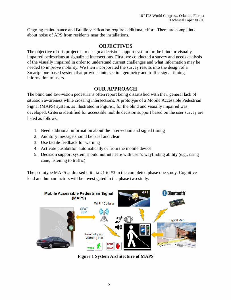
OUR APPROACH The blind and low-vision pedestrians often report being dissatisfied with their general lack of situation awareness while crossing intersections. A prototype of a Mobile Accessible Pedestrian Signal (MAPS) system, as illustrated in Figure1, for the blind and visually impaired was developed. Criteria identified for accessible mobile decision support based on the user survey are listed as follows.
1. Need additional information about the intersection and signal timing 2. Auditory message should be brief and clear 3. Use tactile feedback for warning 4. Activate pushbutton automatically or from the mobile device 5. Decision support system should not interfere with user’s wayfinding ability (e.g., using
cane, listening to traffic) The prototype MAPS addressed criteria #1 to #3 in the completed phase one study. Cognitive load and human factors will be investigated in the phase two study.
Figure 1 System Architecture of MAPS
18th ITS World Congress, Orlando, Florida Technical Paper #1226
6
Our goal is to integrate information from sensors commonly available on a Smartphone that determines a user’s location and heading. Upon confirming crossing direction, the Smartphone application will wirelessly communicate with a traffic signal controller to obtain real-time Signal Phasing and Timing (SPaT) information that can then inform the blind pedestrian when to initiate safe crossing. A roadside device is also installed inside the traffic controller cabinet to obtain SPaT and activate pedestrian call (27). This roadside unit won’t be necessary when intersections are controlled by an Advanced Traffic Controller (ATC) equipped with wireless communication interface. An automated “pedestrian call” (i.e., request for walk signal) request can be sent to the traffic controller wirelessly from a Smartphone of registered blind users after confirming the direction and orientation that the pedestrian is intending to cross. Incoming phone calls on Smartphone will temporarily be ignored or blocked while a pedestrian is crossing. The MAPS eliminates the need of physically locating and pressing a pushbutton at the intersection crossing and provides supportive information to blind pedestrians while traveling along the crosswalk.
USER INTERFACE A Google Android application is developed to obtain positioning (through GPS receiver) and heading (through digital compass and accelerometers) information from a Smartphone for determining user’s location and heading at an intersection. A digital map consists of geo-location of each corner of an intersection was created and stored in a database. When necessary, a Bluetooth-based geo-ID tag can be placed at corner of an intersection with weak or no GPS signals. The Smartphone application will scan for Bluetooth device and use the found geo-ID (MAC address) to obtain the geospatial information of an intersection previously stored in a database. While standing at a corner of an intersection, the blind user can point the Smartphone to desired direction and tap on the phone once to obtain intersection information through Text-To-Speech (TTS) technology with message such as “Washington Avenue, 4 lanes, heading north” (Figure 2). After determining which direction to cross, the blind user can point the phone toward desired direction and double tap the Smartphone screen to confirm direction of crossing. A pedestrian call request will be sent to traffic signal controller through Wi-Fi or cellular network after confirmation. The MAPS system will then obtain signal timing and transmit audio message such as “Wait for signal” or “Walk phase is on, 20 seconds to cross” to users (Figure 3). The MAPS system can potentially take advantage of the data communication environment with DSRC to provide timely decision support and intersection information to people with vision impairment. It will not only expand the accessibility and mobility of the blind and of the elderly but will also reduce the risk of a mishap at intersection crossings.

18th ITS World Congress, Orlando, Florida Technical Paper #1226
7
Figure 2 Single-Tap to Obtain Intersection Geometry Information
Figure 3 Double-Tap to Confirm Crossing and Obtain Signal Information
EXPERIMENT
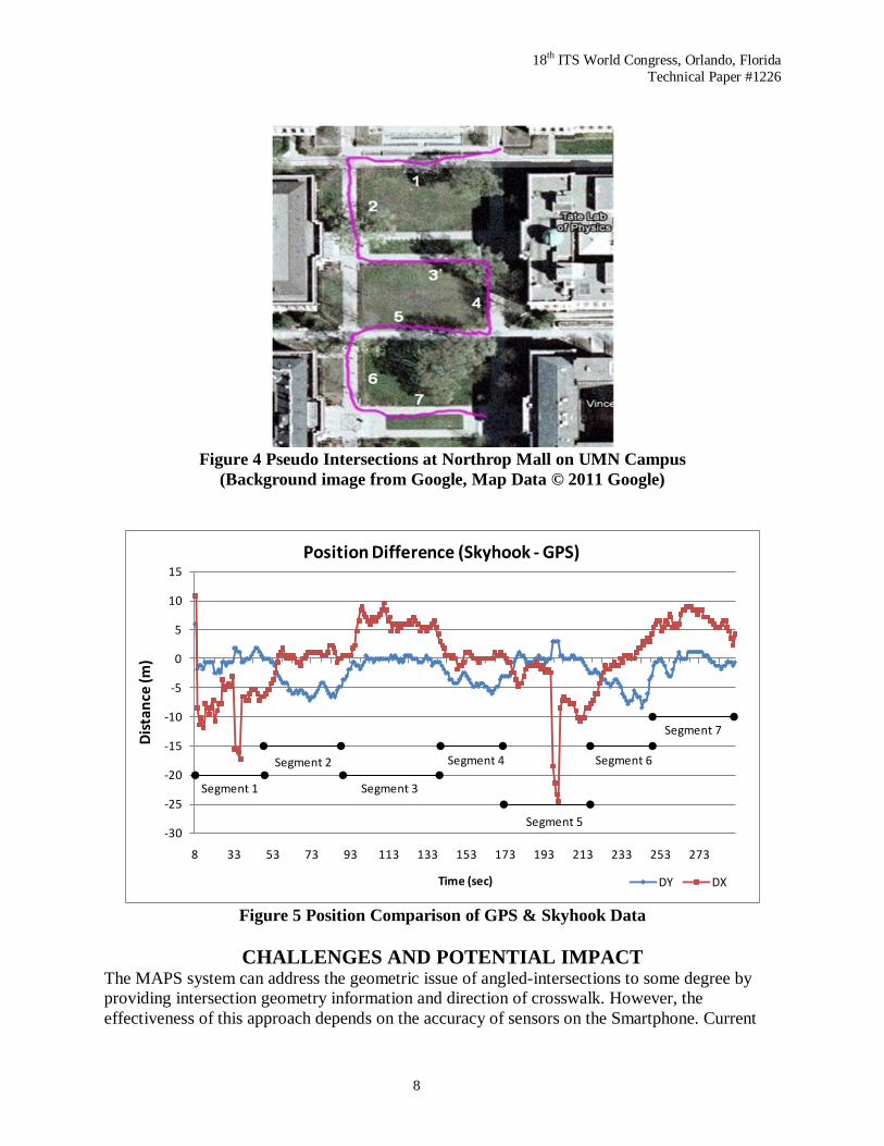
Pseudo intersections at Northrop mall area on University of Minnesota (UMN) campus is chosen for prototype testing. A walking path containing seven sidewalk segments, as illustrated in Figure 4, is selected as reference for comparing GPS and Skyhook positioning solution. Positioning difference between the GPS and Skyhook data, shown in Figure 5, is within ±10 meters except at couple locations in segment 1 and 5 where the position difference in longitudinal direction (X) reaches up to 25 meters. The position difference in the latitudinal direction is within +5/-10 meters throughout the test period.
18th ITS World Congress, Orlando, Florida Technical Paper #1226
8
Figure 4 Pseudo Intersections at Northrop Mall on UMN Campus
(Background image from Google, Map Data © 2011 Google)
-30
-25
-20
-15
-10
-5
0
5
10
15
8 33 53 73 93 113 133 153 173 193 213 233 253 273
Dis
tanc
e (m
)
Time (sec)
Position Difference (Skyhook - GPS)
DY DX
Segment 1
Segment 2 Segment 4
Segment 3
Segment 5
Segment 6
Segment 7
Figure 5 Position Comparison of GPS & Skyhook Data
CHALLENGES AND POTENTIAL IMPACT
The MAPS system can address the geometric issue of angled-intersections to some degree by providing intersection geometry information and direction of crosswalk. However, the effectiveness of this approach depends on the accuracy of sensors on the Smartphone. Current
18th ITS World Congress, Orlando, Florida Technical Paper #1226
9
GPS accuracy on the Smartphone can reach up to 10 meters in open environment. The digital compass has accuracy of 10 degree depending on the magnetic noises in the environment. Pedestrian dead-reckoning solution using high performance sensors can provide better navigation solution assuming accurate initial position and orientation is available. Another solution might use image processing for identifying the zebra crossing as proposed by Shen et al. (28). The MAPS aims to provide decision support for the blind pedestrians at signalized intersection crossing, not to replace wayfinding skills already learned from orientation and mobility training. There are concerns over the noise, the pushbutton locating, and the installation and maintenance costs associated with current APS systems. In the long term, the MAPS system has the potential and capability to enhance, if not replace, existing APS systems. Given the elimination of conduits carrying signals and power to the vibrotactile buttons located around the intersection, the MAPS system can be deployed on a larger scale and more cost effective manner. Intersections equipped with Dedicated Short Range Communications (DSRC) will advance the capabilities of MAPS to the next level of safety applications. In the near-term, the MAPS will take advantage of the low-latency capability of DSRC to coordinate cooperative communication among the pedestrian (waiting at the crossing), the traffic signal controller and approaching vehicles in order to provide dynamic decision-making support to the travelers. Information such as the presence of a blind pedestrian waiting at the crossing can be made available via DSRC to alert drivers attempting to make a turn. Or, the traffic controller can hold or extend the walk signal for the blind pedestrians until they are completely cleared at the crosswalk. Furthermore, DSRC-based wireless connectivity can promptly warn the blind pedestrians not to cross when an approaching vehicle is not likely to stop at the crosswalk while the light is transitioning into red for automobiles. Even though the proposed MAPS system is primarily targeted towards the blind and the elderly, there are also potential benefits for sighted pedestrians that may be distracted (while for example talking or texting on their cell phone) while at the intersection crossing. Integrated DSRC and MAPS system can inform pedestrians prior to entering the crosswalk when there is a potential conflict between vehicles and pedestrians.
SUMMARY People with vision impairment generally have difficulty crossing intersections due to the lack of information available to them about the traffic, signals and intersection geometry. Among the intersection crossing sub-tasks, locating the crosswalk, determining when to cross and maintaining alignment with the crosswalk while crossing are the most difficult tasks for the blind and visually impaired to execute. The current Accessible Pedestrian Signal (APS) system requires the blind to search for a pushbutton if one even exists. It often requires the pedestrian to move away from their path of travel, which is often used as an alignment cue for crossing. Due to the high cost of the APS installation, most agencies do not deploy them at all signalized intersections. In addition to the installation and maintenance costs that accrue to the local traffic agency, current APS systems contribute significant “noise” to the local neighborhood. Furthermore, the auditory guiding cues provided by the APS are often inaudible because of the ambient traffic noise associated with rush hour. There is room for improvement in terms of the
18th ITS World Congress, Orlando, Florida Technical Paper #1226
10
design and accessibility of both APS and non-APS crosswalk signals for blind and low-vision pedestrians. Among the intersection crossing sub-tasks, locating crosswalk, determining when to cross and maintaining alignment to crosswalk while crossing are the most difficult tasks for the blind and visually impaired. We developed a Mobile Accessible Pedestrian Signals (MAPS) prototype to support decision making at signalized intersections. The MAPS system integrates sensors on a Smartphone, Wi-Fi, and Bluetooth technologies, and traffic signal controllers were developed to provide intersection geometry information and Signal Phasing and Timing (SPaT) to pedestrians who are blind at signalized intersections. A single-tap command on the Smartphone screen allows users to request for intersection geometry information, such as street name, direction and number of lanes at a corner of an intersection. A double-tap input while pointing toward desired direction of crossing will confirm the crossing direction, request for pedestrian phase, and the Smartphone application will then wirelessly request for signal timing and phasing information from traffic signal controller. People who are blind usually use the sidewalk boundaries as natural alignment for determining the direction of crosswalk. They usually encounter difficulties finding the way at intersections that are not rectangular. The MAPS system can address the issue of angled-intersections to some degree by providing intersection geometry information and direction of crosswalk. However, the effectiveness of this approach depends on the accuracy of sensors on the Smartphone. Knowing a crosswalk exists and finding the beginning of a crosswalk are two additional challenging tasks for blind pedestrian wayfinding. The Bluetooth geo-ID can help inform and confirm the blind pedestrians that they are at a corner of an intersection. However, the blind pedestrians need to use the wayfinding skills they learned from orientation and mobility training to find the beginning of crosswalk.
ONGOING WORK The current prototype has successfully demonstrated its capability to provide signal timing and intersection geometry to users at a test site. In the second phase of our project, we will focus on developing a reliable pedestrian navigation solution in order to effectively provide veering warnings to blind pedestrian at crossings. We also plan to conduct field testing to study the cognitive load on blind pedestrians using this type of device at intersection crossings.
ACKNOWLEDGEMENTS The author would like to thank the Intelligent Transportation Systems (ITS) Institute and Center for Transportation Studies (CTS), University of Minnesota, for supporting this project. The ITS Institute is a federally funded program administrated through the Research & Innovative Technology Administration (RITA). Many thanks to Linda Spaulding, a Certified Orientation and Mobility Specialist (COMS), who shared her expertise on teaching mobility skills for the blind, Michael Rakauskas for interviewing ten blind pedestrians, and Avanish Rayankula for supporting Smartphone programming. The author is also grateful for numerous discussion and thoughtful insights from Professor Gordon Legge (Department of Psychology) and Professor Herbert Pick (Institute of Child Development) at University of Minnesota.

18th ITS World Congress, Orlando, Florida Technical Paper #1226
11
REFERENCES
(1) US Census, (2008). Americans With Disabilities: 2005. http://www.census.gov/prod/ 2008pubs/p70-117.pdf, accessed May 2011.
(2) FHWA APS Settlement (2005), http://www.acb.org/pedestrian/fhwa-letter-concerning-aps11.html, accessed May 2011.
(3) Ponchillia, P., Rak, E., Freeland, A., & LaGrow, S. (2007). Accessible GPS: Reorientation and Target Location Among Users with Visual Impairments. Journal of Visual Impairment & Blindness, 101(7), 389-401.
(4) Barlow, J.M., Bentzen, B.L., & Bond, T. (2005). Blind Pedestrians and the Changing Technology and Geometry of Signalized Intersections: Safety, Orientation, and Independence. J. of Visual Impairment & Blindness, 99(10), 587-598.
(5) Guth, D. (2007). Why Does Training Reduce Blind Pedestrians’ Veering? In J. J. Rieser, D. H. Ashmead, F. Ebner & A. L. Corn (Eds.), Blindness and Brain Plasticity in Navigation and Object Perception (pp. 353-365): Psychology Press.
(6) Bentzen, B. L., Barlow, J. M., & Franck, L. (2000). Addressing barriers to blind pedestrians at signalized intersections. J. of Institute of Transportation Engineers (ITE). 70(9), 32-35.
(7) Harkey, D.L., Carter, D.L., Barlow, J.M., & Bentzen, B.L., (2010). Accessible Pedestrian Signals: A Guide to Best Practices (Workshop Edition 2010), NCHRP 3-62A, Transportation Research Board. http://onlinepubs.trb.org/onlinepubs/nchrp/nchrp_w150. pdf, accessed June, 2011.
(8) Tauchi, M., H. Sawai, J. Takato, T. Yoshiura, and K. Takeuchi. (1998) Development and Evaluation of a Novel Type of Audible Traffic Signal for the Blind Pedestrians. The 9th International Mobility Conference Proceedings. Rehabilitation Research and Development Center, Veterans Administration Medical Center, Decatur, GA, pp 108–109.
(9) Long, R. (2007). Crossing Streets Without Vision: Access to Information, Strategies for Traveling, and the Impact of Technology, Training, and Environmental Design. In J. J. Rieser, D. H. Ashmead, F. Ebner & A. L. Corn (Eds.), Blindness and Brain Plasticity in Navigation and Object Perception (pp. 335-351): Psychology Press.
(10) Bohonos, S., Lee, A., Malik, A., Thai, C., & Manduchi, R. (2008). Cellphone Accessible Information via Bluetooth Beaconing for the Visually Impaired. Santa Cruz: University of California, Santa Cruz.
(11) Golledge, R. G. & Gärling, T., (2004). Cogntive maps and urban travel, in: D. A. Hensher, K. J. Button, K. E. Haynes and P. R. Stopher (Eds) Handbook of Transport Geography and Spatial Systems, Ch. 28. Amsterdam: Elsevier.
(12) Guth, D., & LaDuke, R., (1995). Veering by blind pedestrians: Individual differences and their implications for instruction. Journal of Visual Impairment & Blindness, 89, 28–37.
(13) Kallie, C. S., Schrater, P. R., & Legge, G. E. (2007). Variability in stepping direction explains the veering behavior of blind walkers. Journal of Experimental Psychology: Human Perception and Performance, 33(1), 183-200.
(14) Giudice, N. A. & Legge, G. E., (2008). Blind Navigation and the Role of Technology, in The Engineering Handbook of Smart Technology for Aging, Disability, and Independence
18th ITS World Congress, Orlando, Florida Technical Paper #1226
12
(eds A. Helal, M. Mokhtari and B. Abdulrazak), John Wiley & Sons, Inc., Hoboken, NJ, USA.
(15) The e-Adept accessibility project (2009). http://www.eadept.se, accessed October 2009. (16) Jonsson, A., Sandberg, S., & Uppgård, T., (2007). Urban guidance for the blind and
visually impaired – pedestrian route planning and navigation using a mobile handset, Expanding the Knowledge Economy: Issues, Applications. Case Studies, Paul Cunningham and Miriam Cunningham (Eds), IOS Press, 2007 Amsterdam, ISBN: 978-1-58603-801-4.
(17) Dawidson, E., (2009). Pedestrian Navigation in Stockholm, How Local Data Together with Advanced Positioning Techniques Can be Used for Detailed Routing. Proceedings of the 16th ITS World Congress, Stockholm, Sweden.
(18) Johnni, P., (2009). Stockholm – A City for Everyone How New Technology Can Make Every Day Life Easier for Elderly and People with Disabilities. Proceedings of the 16th ITS World Congress, Stockholm, Sweden.
(19) The NOPPA project (2009). http://virtual.vtt.fi/virtual/noppa/noppaeng.htm, accessed October, 2009.
(20) Virtanen A. & S. Koshinen (2004). NOPPA – Navigation and Guidance System for the Blind. Proceedings of the 11th ITS World Congress, Nagoya, Japan.
(21) Barbeau, S.J., Georggi, N.L., & Winters, P.L. (2010), Integration of GPS-Enabled Mobile Phones and AVL: Personalized Real-Time Transit Navigation Information on Your Phone, Proceedings of the National Academy of Sciences, Transportation Research Board 89th Annual Meeting, Washington, D.C. http://www.locationaware.usf.edu/wp-content/uploads/2010/04/TRB2010-Paper.pdf, accessed July, 2010
(22) The ASK-IT project (2009). http://www.ask-it.org/, accessed October 2009. (23) Bekiaris, E. , K. Kalogirou, & M. Panou, (2007), Personalised infomobility services within
ASK-IT project. Proceedings of the 14th ITS World Congress, Beijing, China. (24) Edwards, S., Bryan, H., & Wagner, J., (2007). Indoor Localisationfor Disabled People:
ASK-IT Project, Proceedings of the 14th ITS World Congress, Beijing, China. (25) Coldefy, J., (2009). The Mobiville Project: Large Scale Experimentation of Real-Time
Public Transport Information Service Providing Satellite Based Pedestrian Guidance on Smartphones. Proceedings of the 16th ITS World Congress, Stockholm, Sweden.
(26) Markoff, J., & Fackler, M., (2006). With a Cellphone as My Guide, The New York Times. http://www.nytimes.com/2006/06/28/technology/28locate.html, accessed June 2009.
(27) Liu, H., Wu, X., Ma, W., and Hu, H. (2009) Real-Time Queue Length Estimation for Congested Signalized Intersections, Transportation Research Part C, 17(4), 412-427.
(28) Shen, H., Coughlan, J. & Ivanchenko, V., (2009). Figure-Ground Segmentation Using Factor Graphs. Special Issue of Image and Vision Computing. Vol. 27, Issue 7.