mngeo state government advisory council meeting november 13, 2012
TRANSCRIPT
MnG
eo State Governm
ent Advisory Council Meeting
MnG
eo State Governm
ent Advisory Council Meeting
STATE GOVERNMENT GEOSPATIAL ADVISORY
COUNCILNovember 13, 2012
MnG
eo State Governm
ent Advisory Council Meeting
MnG
eo State Governm
ent Advisory Council Meeting
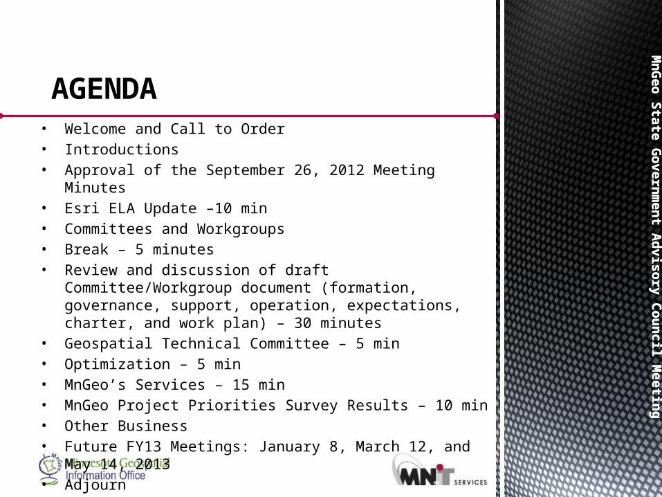
• Welcome and Call to Order • Introductions • Approval of the September 26, 2012 Meeting Minutes • Esri ELA Update –10 min • Committees and Workgroups • Break – 5 minutes • Review and discussion of draft Committee/Workgroup
document (formation, governance, support, operation, expectations, charter, and work plan) – 30 minutes
• Geospatial Technical Committee – 5 min • Optimization – 5 min • MnGeo’s Services – 15 min • MnGeo Project Priorities Survey Results – 10 min • Other Business • Future FY13 Meetings: January 8, March 12, and May 14,
2013 • Adjourn
AGENDA
MnG
eo State Governm
ent Advisory Council Meeting
MnG
eo State Governm
ent Advisory Council Meeting
Chris Cialek
Esri ELA Update
MnG
eo State Governm
ent Advisory Council Meeting
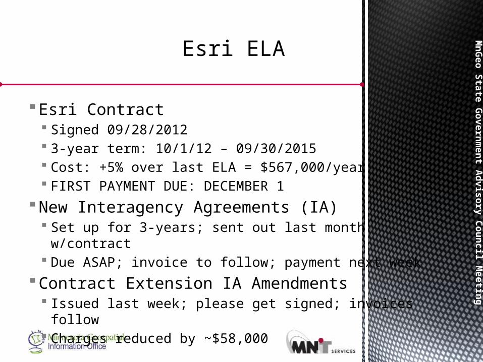
Esri Contract Signed 09/28/2012 3-year term: 10/1/12 – 09/30/2015 Cost: +5% over last ELA = $567,000/year FIRST PAYMENT DUE: DECEMBER 1
New Interagency Agreements (IA) Set up for 3-years; sent out last month w/contract Due ASAP; invoice to follow; payment next week
Contract Extension IA Amendments Issued last week; please get signed; invoices follow Charges reduced by ~$58,000
Esri ELA
MnG
eo State Governm
ent Advisory Council Meeting
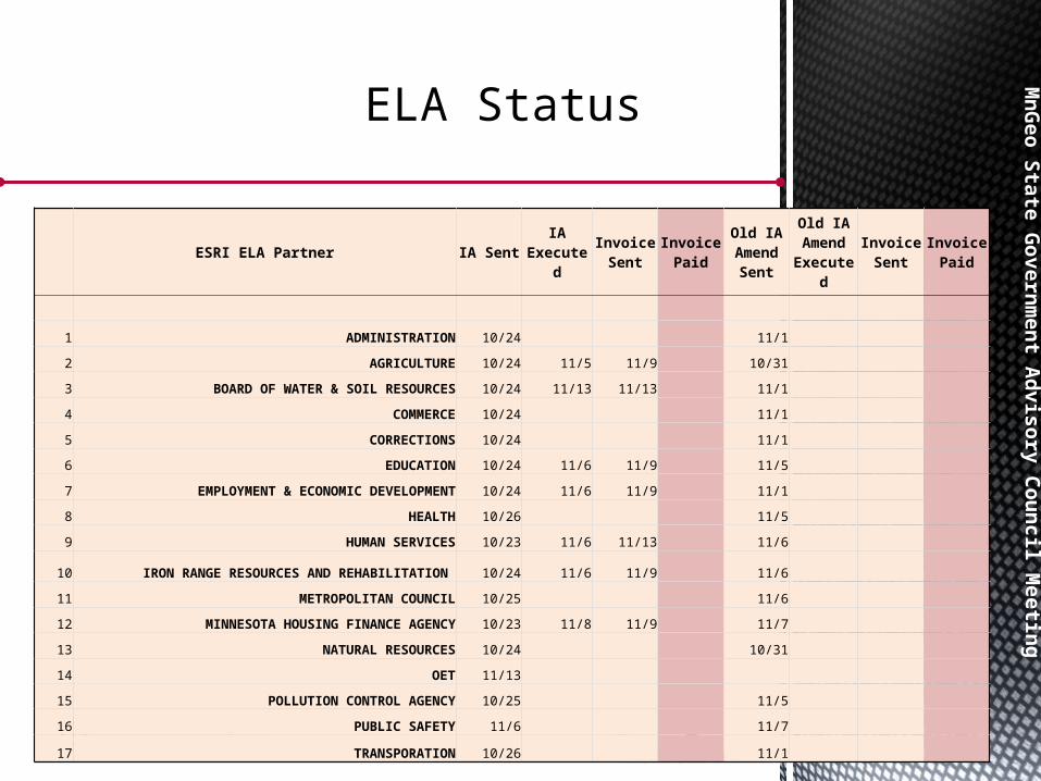
ELA Status
ESRI ELA Partner IA Sent IA Executed
Invoice Sent
Invoice Paid
Old IA Amend
Sent
Old IA Amend
ExecutedInvoice
SentInvoice
Paid
1 ADMINISTRATION 10/24 11/1
2 AGRICULTURE 10/24 11/5 11/9 10/31
3 BOARD OF WATER & SOIL RESOURCES 10/24 11/13 11/13 11/1
4 COMMERCE 10/24 11/1
5 CORRECTIONS 10/24 11/1
6 EDUCATION 10/24 11/6 11/9 11/5
7 EMPLOYMENT & ECONOMIC DEVELOPMENT 10/24 11/6 11/9 11/1
8 HEALTH 10/26 11/5
9 HUMAN SERVICES 10/23 11/6 11/13 11/6
10 IRON RANGE RESOURCES AND REHABILITATION 10/24 11/6 11/9 11/6
11 METROPOLITAN COUNCIL 10/25 11/6
12 MINNESOTA HOUSING FINANCE AGENCY 10/23 11/8 11/9 11/7
13 NATURAL RESOURCES 10/24 10/31
14 OET 11/13
15 POLLUTION CONTROL AGENCY 10/25 11/5
16 PUBLIC SAFETY 11/6 11/7
17 TRANSPORATION 10/26 11/1
MnG
eo State Governm
ent Advisory Council Meeting
MnG
eo State Governm
ent Advisory Council Meeting
Discussion - Committees & Workgroups –
How do we optimize their
efforts?
MnG
eo State Governm
ent Advisory Council Meeting
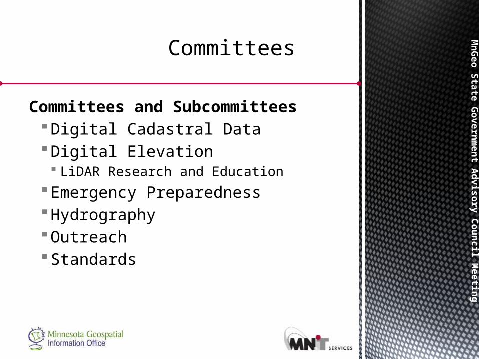
Committees and SubcommitteesDigital Cadastral DataDigital Elevation LiDAR Research and Education
Emergency PreparednessHydrographyOutreachStandards
Committees
MnG
eo State Governm
ent Advisory Council Meeting
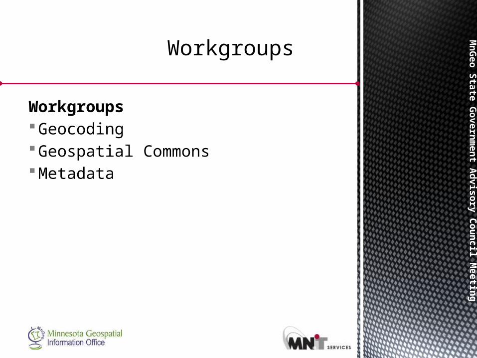
WorkgroupsGeocodingGeospatial CommonsMetadata
Workgroups
Mn
Geo S
tate
Govern
men
t Ad
vis
ory
Cou
ncil M
eetin
gM
nG
eo S
tate
Govern
men
t Ad
vis
ory
Cou
ncil M
eetin
g
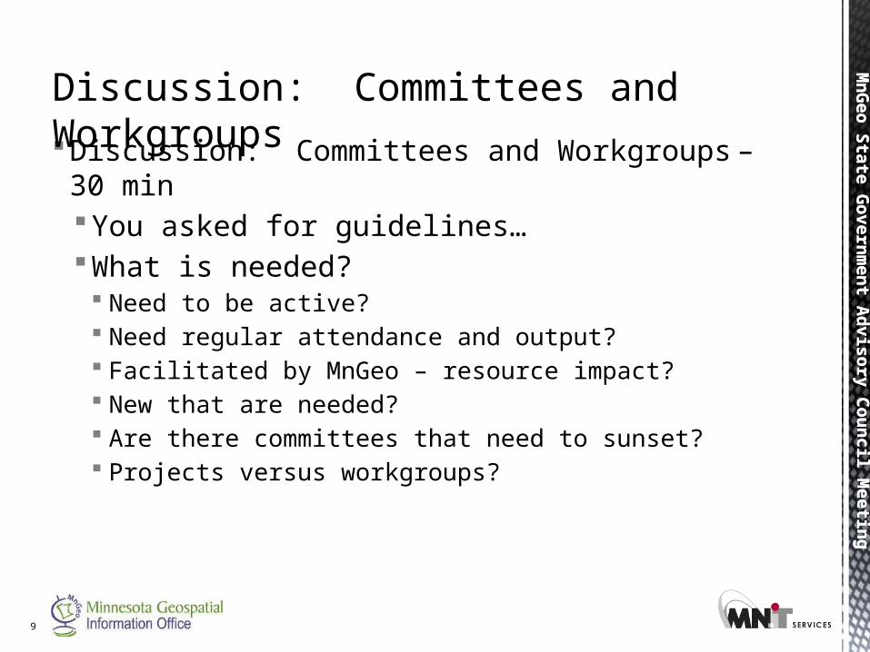
Discussion: Committees and Workgroups – 30 minYou asked for guidelines…What is needed? Need to be active? Need regular attendance and output? Facilitated by MnGeo – resource impact? New that are needed? Are there committees that need to sunset? Projects versus workgroups?
9
Discussion: Committees and Workgroups
Mn
Geo S
tate
Govern
men
t Ad
vis
ory
Cou
ncil M
eetin
g
Geospatial Technical
Committee
Mn
Geo S
tate
Govern
men
t Ad
vis
ory
Cou
ncil M
eetin
gM
nG
eo S
tate
Govern
men
t Ad
vis
ory
Cou
ncil M
eetin
g
11
Mn
Geo S
tate
Govern
men
t Ad
vis
ory
Cou
ncil M
eetin
gM
nG
eo S
tate
Govern
men
t Ad
vis
ory
Cou
ncil M
eetin
g
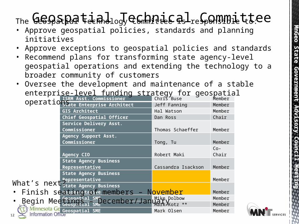
ISRM Asst. Commissioner Chris Buse MemberState Enterprise Architect Jeff Fanning MemberGIS Architect Hal Watson MemberChief Geospatial Officer Dan Ross ChairService Delivery Asst. Commissioner Thomas Schaeffer MemberAgency Support Asst. Commissioner Tong, Tu Member
Agency CIO Robert Maki Co-Chair
State Agency Business Representative Cassandra Isackson MemberState Agency Business Representative MemberState Agency Business Representative MemberGeospatial SME Mike Dolbow MemberGeospatial SME Mark Kotz ** MemberGeospatial SME Mark Olsen Member
12
Geospatial Technical CommitteeThe Geospatial Technology Committee is responsible to:• Approve geospatial policies, standards and planning initiatives • Approve exceptions to geospatial policies and standards • Recommend plans for transforming state agency-level geospatial
operations and extending the technology to a broader community of customers
• Oversee the development and maintenance of a stable enterprise-level funding strategy for geospatial operations
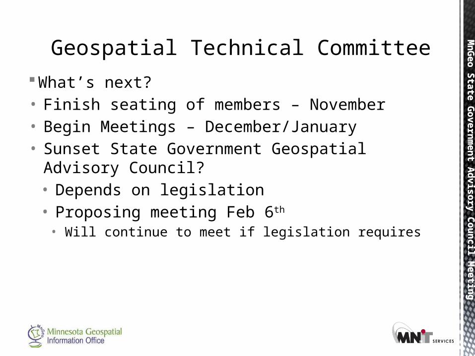
What’s next?• Finish seating of members – November• Begin Meetings – December/January
Mn
Geo S
tate
Govern
men
t Ad
vis
ory
Cou
ncil M
eetin
gM
nG
eo S
tate
Govern
men
t Ad
vis
ory
Cou
ncil M
eetin
g
What’s next?• Finish seating of members – November• Begin Meetings – December/January• Sunset State Government Geospatial Advisory
Council?• Depends on legislation• Proposing meeting Feb 6th
• Will continue to meet if legislation requires
Geospatial Technical Committee
MnG
eo State Governm
ent Advisory Council Meeting
MnG
eo State Governm
ent Advisory Council Meeting
Optimization (update) -
Phase Four of Consolidation
Mn
Geo S
tate
Govern
men
t Ad
vis
ory
Cou
ncil M
eetin
gM
nG
eo S
tate
Govern
men
t Ad
vis
ory
Cou
ncil M
eetin
g
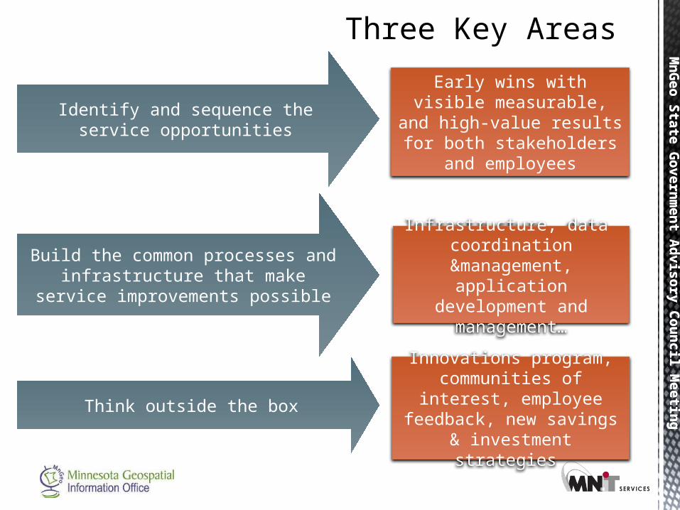
Three Key Areas
Identify and sequence the service opportunities
Early wins with visible measurable, and high-value results for both
stakeholders and employees
Build the common processes and infrastructure that make service
improvements possible
Think outside the box
Infrastructure, data coordination
&management, application development
and management…
Innovations program, communities of interest, employee feedback, new
savings & investment strategies
Mn
Geo S
tate
Govern
men
t Ad
vis
ory
Cou
ncil M
eetin
gM
nG
eo S
tate
Govern
men
t Ad
vis
ory
Cou
ncil M
eetin
g
16
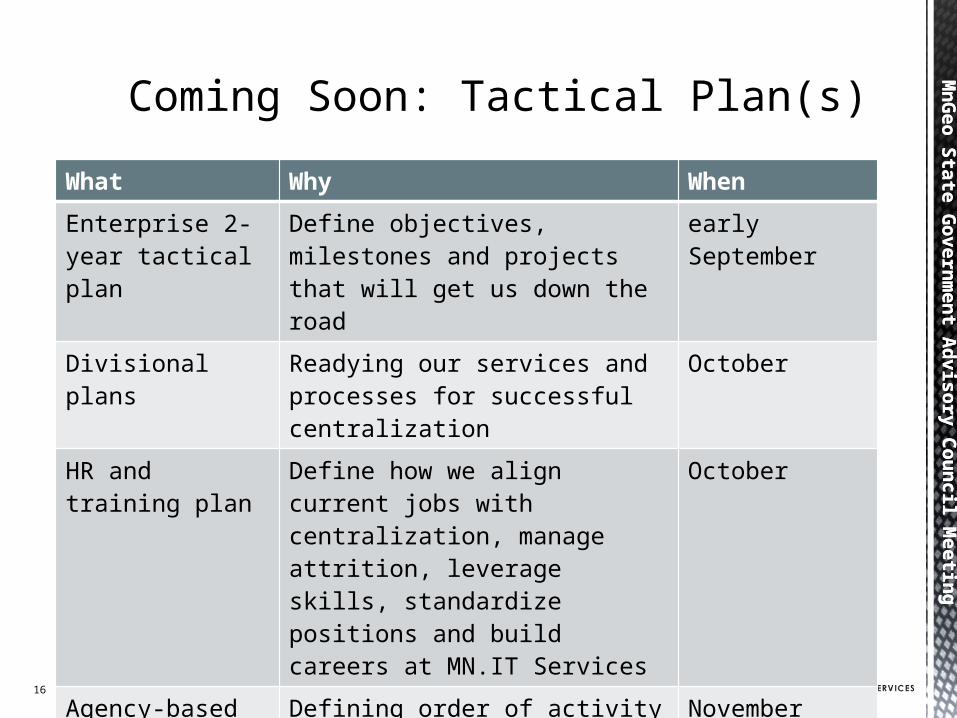
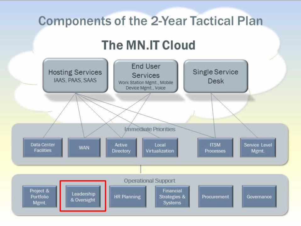
Coming Soon: Tactical Plan(s)
Make the “factory side” of IT super efficient so we can
focus our people, money and creativity on the
services that most directly make a difference for our customers and citizens
What Why When
Enterprise 2-year tactical plan
Define objectives, milestones and projects that will get us down the road
early September
Divisional plans Readying our services and processes for successful centralization
October
HR and training plan
Define how we align current jobs with centralization, manage attrition, leverage skills, standardize positions and build careers at MN.IT Services
October
Agency-based office plans
Defining order of activity that meets the overall objectives
November
Mn
Geo S
tate
Govern
men
t Ad
vis
ory
Cou
ncil M
eetin
g
Click to add the caption or title for the picture
Click icon to add picture
Mn
Geo S
tate
Govern
men
t Ad
vis
ory
Cou
ncil M
eetin
gM
nG
eo S
tate
Govern
men
t Ad
vis
ory
Cou
ncil M
eetin
g
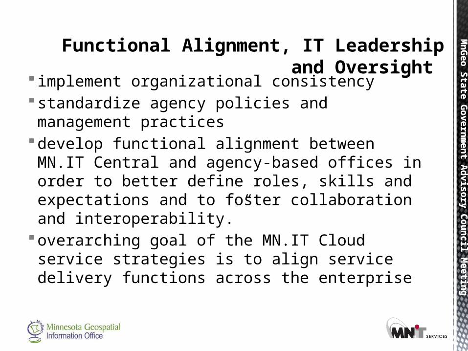
implement organizational consistency standardize agency policies and management practices develop functional alignment between MN.IT Central
and agency-based offices in order to better define roles, skills and expectations and to foster collaboration and interoperability.”
overarching goal of the MN.IT Cloud service strategies is to align service delivery functions across the enterprise
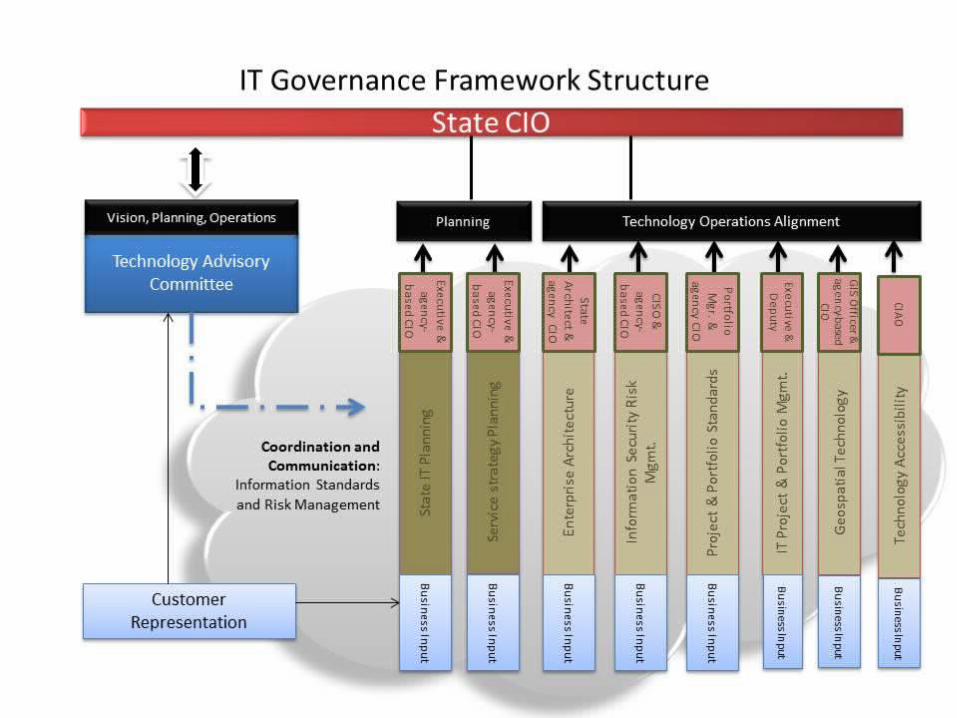
Functional Alignment, IT Leadership and Oversight
Mn
Geo S
tate
Govern
men
t Ad
vis
ory
Cou
ncil M
eetin
gM
nG
eo S
tate
Govern
men
t Ad
vis
ory
Cou
ncil M
eetin
g
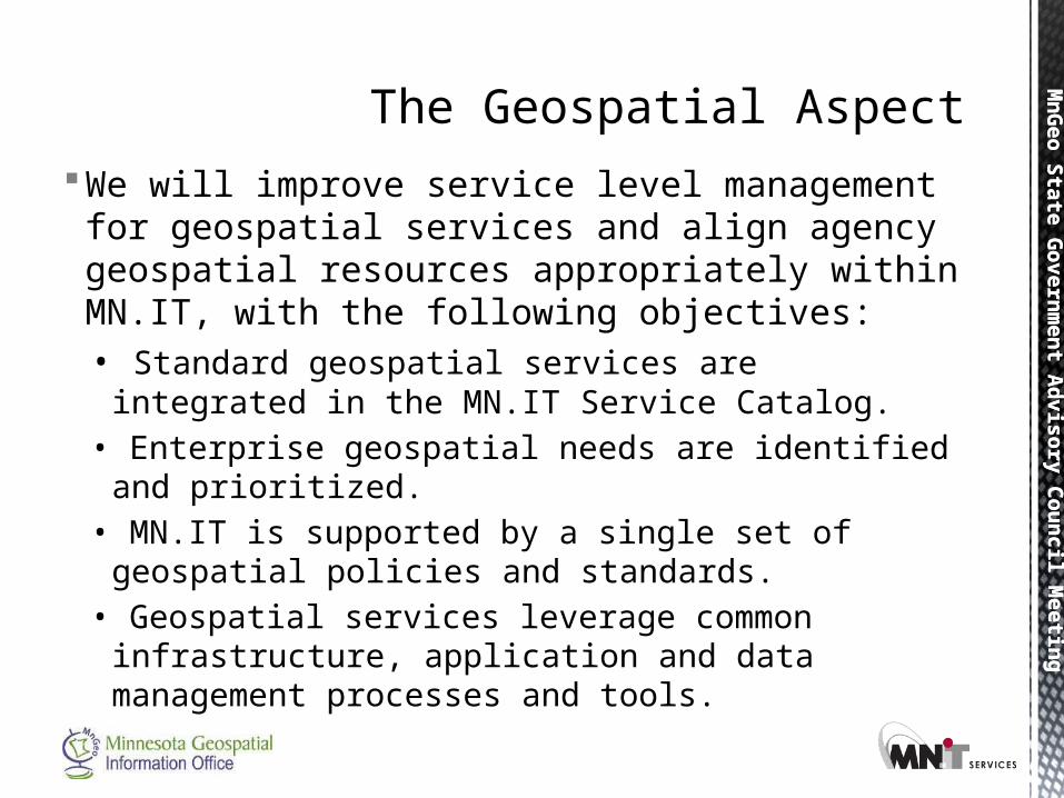
We will improve service level management for geospatial services and align agency geospatial resources appropriately within MN.IT, with the following objectives:
• Standard geospatial services are integrated in the MN.IT Service Catalog.
• Enterprise geospatial needs are identified and prioritized.
• MN.IT is supported by a single set of geospatial policies and standards.
• Geospatial services leverage common infrastructure, application and data management processes and tools.
The Geospatial Aspect

Mn
Geo S
tate
Govern
men
t Ad
vis
ory
Cou
ncil M
eetin
gM
nG
eo S
tate
Govern
men
t Ad
vis
ory
Cou
ncil M
eetin
g
A complete set of enterprise policies for geospatial services will be published by the end of Q4, FY13, and the executive branch will share a common geospatial infrastructure and data foundation by the end of Q4, FY14.
Time frames and deliverables
Mn
Geo S
tate
Govern
men
t Ad
vis
ory
Cou
ncil M
eetin
gM
nG
eo S
tate
Govern
men
t Ad
vis
ory
Cou
ncil M
eetin
g
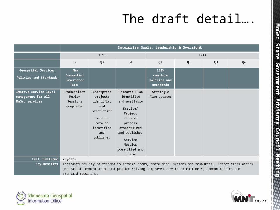
Enterprise Goals, Leadership & Oversight
FY13 FY14
Q2 Q3 Q4 Q1 Q2 Q3 Q4
The draft detail….
Geospatial Services
Policies and Standards
New Geospatial
Governance Team
100% complete
policies and standards
Improve service level management for all MnGeo services
Stakeholder Review
Sessions completed
Enterprise projects
identified and
prioritized
Service catalog
identified and published
Resource Plan identified and
available
Service/Project request process
standardized and published
Service Metrics identified and in
use
Strategic Plan updated
Full Timeframe 2 years
Key Benefits Increased ability to respond to service needs, share data, systems and resources. Better cross-agency geospatial communication and problem-solving; improved service to customers; common metrics and standard reporting.

Mn
Geo S
tate
Govern
men
t Ad
vis
ory
Cou
ncil M
eetin
gM
nG
eo S
tate
Govern
men
t Ad
vis
ory
Cou
ncil M
eetin
g
Geospatial Services Optimize and standardize core geospatial service delivery Infrastructure
Data Management
Application Development and Management
Guidance, governance and support
Innovation
Optimization teams identified
Agency needs and skill requirements identified Innovation topics defined and prioritized Small teams formed
Infrastructure assessment complete
Governance, skill developmentService Request process Metrics identifiedInfrastructure available
Infrastructure alignment plan
DM assessment complete
Application assessment complete
Resources available to support startups and agency projects
Innovation happening
DM optimization plan
Application optimization plan
Single geospatial Service Desk
Common process and tools defined
Common process/tools in place
Infrastructure Optimization CompleteDM optimization complete
Application optimization complete
Full Timeframe 2 yearsKey Benefits More efficient use of infrastructure and software licensing, common practices in place and used for data and application management,
consistent service request process, better alignment of geospatial resources and skill sets, more agencies implementing geospatial as part of core business processes and systems
More draft details…. Enterprise Goals, Leadership & Oversight
FY13 FY14
Q2 Q3 Q4 Q1 Q2 Q3 Q4
Mn
Geo S
tate
Govern
men
t Ad
vis
ory
Cou
ncil M
eetin
gM
nG
eo S
tate
Govern
men
t Ad
vis
ory
Cou
ncil M
eetin
g
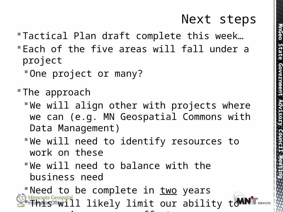
Tactical Plan draft complete this week…Each of the five areas will fall under a project
One project or many?
The approachWe will align other with projects where we can (e.g.
MN Geospatial Commons with Data Management)We will need to identify resources to work on theseWe will need to balance with the business needNeed to be complete in two yearsThis will likely limit our ability to engage in some new
effortsMeeting with larger agencies first
Next steps
Mn
Geo S
tate
Govern
men
t Ad
vis
ory
Cou
ncil M
eetin
g
MnGeo Services
Mn
Geo S
tate
Govern
men
t Ad
vis
ory
Cou
ncil M
eetin
gM
nG
eo S
tate
Govern
men
t Ad
vis
ory
Cou
ncil M
eetin
g
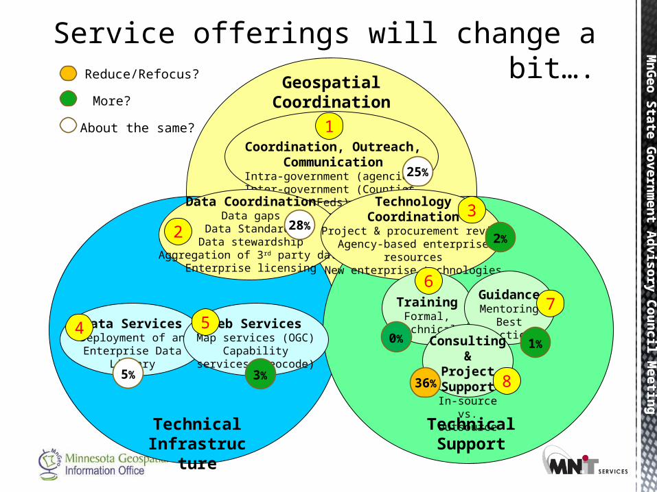
Service offerings will change a bit….
GeospatialCoordination
Technical Infrastructure
Technical Support
Coordination, Outreach, Communication
Intra-government (agencies)Inter-government (Counties, Feds)
Extra-governmentData CoordinationData gaps
Data StandardsData stewardship
Aggregation of 3rd party dataEnterprise licensing
TechnologyCoordination
Project & procurement reviewAgency-based enterprise resources
New enterprise technologies
Data ServicesDeployment of an
Enterprise Data Library
Web ServicesMap services (OGC)
Capability services (geocode)
TrainingFormal, technical
GuidanceMentoring
Best practices
Consulting &Project Support
In-source vs.outsource
1
8
4
32
6
57
36%
25%
28%
0% 1%
2%
3%5%
Reduce/Refocus?
More?
About the same?
Mn
Geo S
tate
Govern
men
t Ad
vis
ory
Cou
ncil M
eetin
g
Project Priorities
Survey Results
Mn
Geo S
tate
Govern
men
t Ad
vis
ory
Cou
ncil M
eetin
g
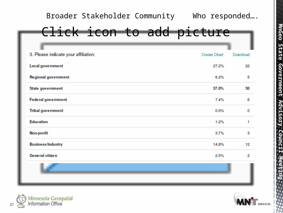
Broader Stakeholder Community Who responded….
Click icon to add picture
27
Mn
Geo S
tate
Govern
men
t Ad
vis
ory
Cou
ncil M
eetin
gM
nG
eo S
tate
Govern
men
t Ad
vis
ory
Cou
ncil M
eetin
g
28
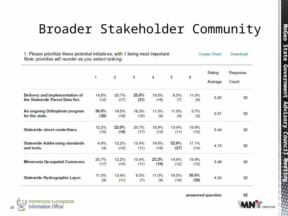
Broader Stakeholder Community
Mn
Geo S
tate
Govern
men
t Ad
vis
ory
Cou
ncil M
eetin
gM
nG
eo S
tate
Govern
men
t Ad
vis
ory
Cou
ncil M
eetin
g
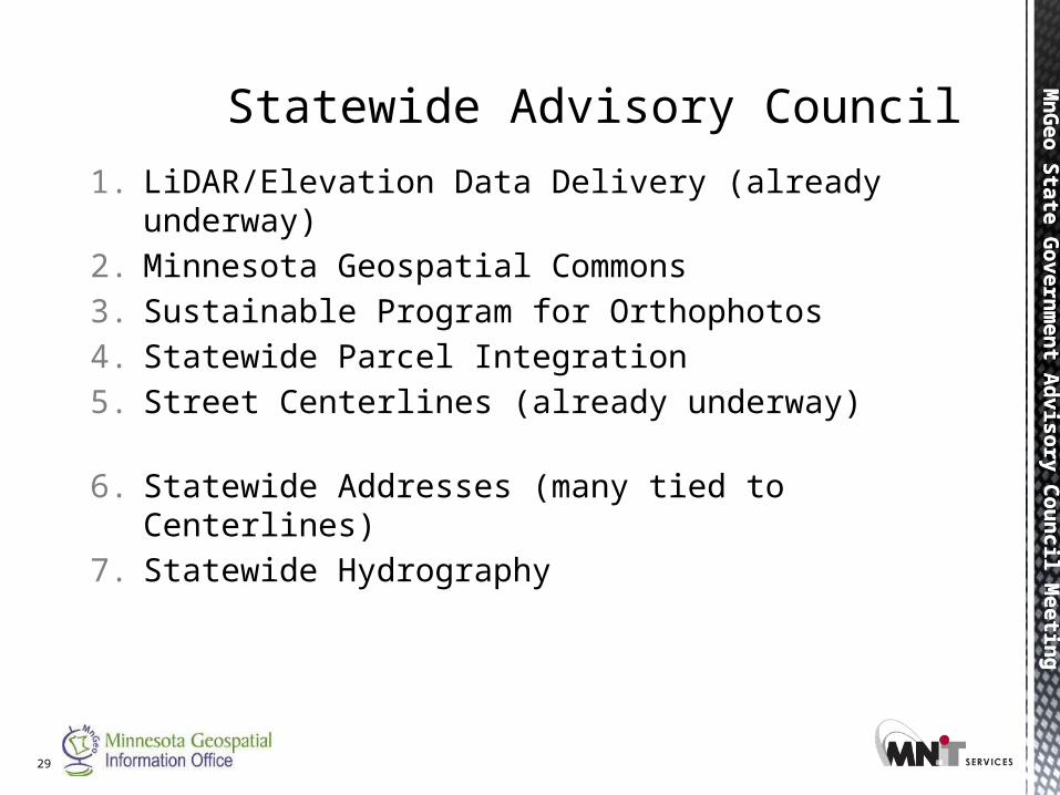
1. LiDAR/Elevation Data Delivery (already underway)
2. Minnesota Geospatial Commons
3. Sustainable Program for Orthophotos
4. Statewide Parcel Integration
5. Street Centerlines (already underway)
6. Statewide Addresses (many tied to Centerlines)
7. Statewide Hydrography
29
Statewide Advisory Council
Mn
Geo S
tate
Govern
men
t Ad
vis
ory
Cou
ncil M
eetin
gM
nG
eo S
tate
Govern
men
t Ad
vis
ory
Cou
ncil M
eetin
g
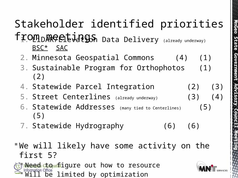
1. LiDAR/Elevation Data Delivery (already underway) BSC* SAC
2. Minnesota Geospatial Commons (4) (1)
3. Sustainable Program for Orthophotos (1)(2)
4. Statewide Parcel Integration (2) (3)
5. Street Centerlines (already underway) (3) (4)
6. Statewide Addresses (many tied to Centerlines) (5) (5)
7. Statewide Hydrography (6)(6)
We will likely have some activity on the first 5? Need to figure out how to resource Will be limited by optimization
*BSC = broad spatial community
Stakeholder identified priorities from meetings
MnG
eo State Governm
ent Advisory Council Meeting
MnG
eo State Governm
ent Advisory Council Meeting
• Other Business • Proposed Future FY13 Meeting: Feb
6• Adjourn
MnG
eo State Governm
ent Advisory Council Meeting
MnG
eo State Governm
ent Advisory Council Meeting