mississippi’s nonpoint sourcethe film includes a rich historical narrative of the watershed and...
TRANSCRIPT
1
Mississippi’s Nonpoint Source Management Program
2011 Annual Report
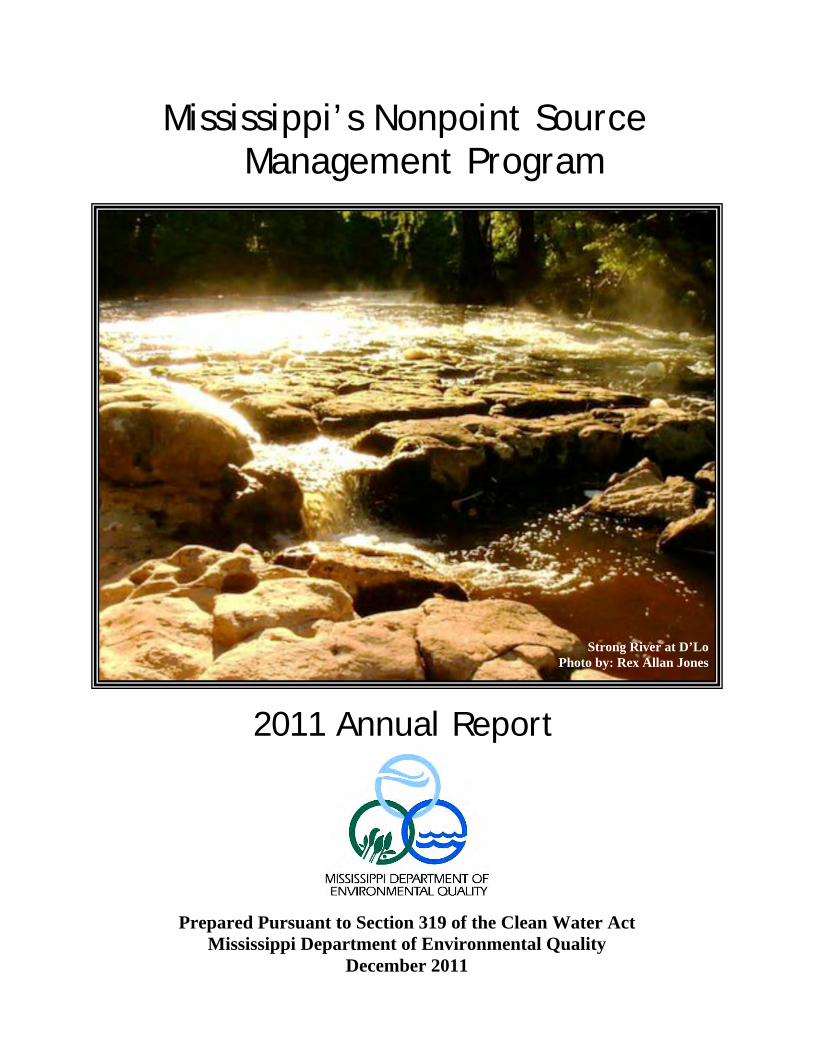
Strong River at D’Lo
Photo by: Rex Allan Jones
n 319 of the Clean Water Act
Prepared Pursuant to SectioMississippi Department of Environmental Quality
December 2011
2
Mississippi’s 2011 Nonpoint Source Program
Annual Report
Table of Contents Executive Summary..........................................(3) Nonpoint Source Pollution Definition ............ (5) History of NPS Program....................................... (6)
First Ten Years Moving into the Future
Highlights of the Year...................................... (7) Assessment & Monitoring/TMDL Activity TMDLs
Stressor Identification Program Mississippi Benthic Index of Stream Quality Mississippi Alluvial Plain Monitoring Geographic Information Systems Mapping Watershed Resource Management System Agrichemical Groundwater Monitoring Program Supplemental Watershed Project Monitoring
Section 319 Watershed Projects ............... (14) Section 319 Grant Awards Graph Program Funding
Map Depicting NPS Watershed Project Locations List of NPS Projects by Name
Numeric Nutrient Criteria Development Nutrient Reduction Strategy Basin Management Approach
Showcased Section 319 Projects……..….(21)
Porter Bayou and Harris Bayou Tarebreeches Creek Watershed Bell Creek – West Prong Muddy Creek Rotten Bayou Red Creek Watershed Ross Barnett Reservoir
NPS Education/Public Outreach................... (30) Adopt-A-Stream Envirothon Competition Watershed Harmony Mississippi Urban Forestry Council Storm Water Workshops Project Earth Teacher Workshops Mississippi and Yazoo River Tours Secchi Day 2011 Environmental Education Events Media, Publications and Literature
NPS-Related Programs...…………………......(40)

3
Nonpoint Source (NPS) Pollution, also known as polluted runoff, has an adverse impact on the State’s water resources. Unlike pollutants from point sources that enter the environment from well-defined discharge points, pollutants from nonpoint sources find their way to surface and ground waters via rainwater runoff or percolation. The polluted runoff can contain sediment, nutrients, bacteria, or toxic materials. Runoff from the seven major land-use categories listed below potentially impacts the State’s water bodies. These categories consist of agriculture, forestry, mining, construction activities, urban runoff, hydrologic modifications, and land-disposal activities. Polluted runoff is a significant cause of water-quality problems in Mississippi. The NPS Pollution Control Program seeks to reduce or eliminate polluted runoff that degrades water bodies in Mississippi. The State’s NPS Management Plan incorporates a strategy for the management and abatement of NPS pollution and relies on statewide and targeted watershed approaches. These approaches are implemented through both regulatory and non-regulatory programs on the federal, state, and local levels. Some of the activities regulated by the State include: construction, stormwater, mining, and hydrologic modifications. The strategies for the management of these activities are to continue developing and implementing educational programs and to continue issuing permits and maintaining compliance and enforcement activities. The implementation of program activities for land-use categories that are not regulated will rely primarily on the voluntary cooperation of stakeholders and will be supported financially through federal assistance programs such as Section 319 and other state resources. The strategies for addressing NPS pollution on a statewide level include education/outreach, assessment and monitoring, use of Best Management Practice (BMP) demonstrations, BMP compliance, technology transfer, consensus building, and partnering. The NPS Management Program also implements a strategy that targets priority watersheds. Prioritization of these watersheds is done by multi-agency teams in the Basin Management Approach (BMA). Within priority watersheds, activities will be implemented to address parameters of concern that appear on the State’s 303(d) list. The State’s NPS Program also incorporates the Coastal NPS Program Strategy, the recently developed Mississippi Delta Nutrient Reduction Strategy, Basin wide Approach Strategy, and the State’s strategy for the development and implementation of NPS Total Maximum Daily Loads (TMDLs). The NPS Program continues to be implemented in cooperation with several agencies, organizations, and groups at all levels of government and in the private sector. A great focus is given to activities that promote consensus building and partnering to increase the overall effectiveness of the State’s NPS Program. The program strategy will be implemented to meet the long-term goals of the program. The long-term goals will, in turn, be achieved by implementing five-year action plans. These plans will be modified as more data and new issues are identified under the BMA. This report relates several accomplishments during calendar year 2011 that directly relate to and support the long-term and short-term action strategies identified in the State’s NPS Management Program. The agreement between MDEQ and the United States Geological Service (USGS), entered into in 2006, continues to provide assessment/monitoring support to priority watersheds. The USGS, along with a number of watershed teams, coordinates the development and implementation of monitoring plans to document water-quality improvements. Other major accomplishments include the development of 360 TMDLs; the continuing effort to develop nutrient, water-quality criteria standards; and the continued success of the musical puppet play Watershed Harmony that shows grade-school students the importance
Executive Summary
Bayou n County
4
of controlling NPS pollution. Other important accomplishments include the further development of the Mississippi Watershed Characterization and Ranking Tool (MWCRT) as well as continued progress in the protection/restoration efforts of specific watershed projects. In addition to these activities, there continues to be much progress in the protection and restoration efforts of specific watershed projects. Seven projects are showcased in this report and include: 1) Porter Nutrient Reduction Project; 2) Harris Bayou Nutrient Reduction Project; 3) Tarebreeches Creek-Tuscumbia River Canal Watershed Project; 4) Bell Creek – West Prong Muddy Creek; 5) Rotten Bayou; 6) Red Creek Watershed and; 7) Ross Barnett Reservoir. Both Porter and Harris Nutrient Reduction Projects are in the Mississippi Delta and are in watersheds comprised mainly of productive agricultural lands, each having about 80 % of their watershed consisting of these types of lands. Naturally, there are much nutrient-laden sediments that need to be reduced and prevented from reaching waters further downstream. So, the main objectives of these projects are to determine what reductions are achievable using Best Management Practices (BMPs) and the cost to implement these practices. Both of these projects serve as noteworthy examples of leveraging resources in a collaborative effort within a multi-agency task force that form the Mississippi River Basin Initiative (MRBI). Projects 3 – 5 listed above are all located in areas of Mississippi where pollutant loadings from agricultural nonpoint sources such as nutrients and pathogens from animal waste are problematic. These pollutants must be and are being reduced through BMPs, some of which include nutrient management, field borders, grade-stabilization structures, sediment-control basins, stream crossings, heavy-use-area protection, and fencing. Project 6, Red Creek Watershed, is an important sub-basin of the Pascagoula River watershed, a nationally significant eco-system and the largest unimpeded watershed in the continental United States. Here, MDEQ has collaborated with local and regional agencies as well as private citizens to successfully restore and enhance an eroded streambank after major bank failure. Public outreach and education have been a big part of this project and have included murals created by schoolchildren as well as a superb documentary film entitled The Search for Red Bluff. The film includes a rich historical narrative of the watershed and describes the potential outcome of poor management of our natural resources and lack of proper BMP implementation. The last project mentioned above, Project 7 – Ross Barnett Reservoir, is a vital resource to central Mississippi. It is the largest source of drinking water in the State and it receives more than 2.5 million visitors annually and many consider it to be the premier recreational water body in Mississippi. EPA has designated this area as a priority watershed. The MDEQ and the Pearl River Valley Water Supply District, along with other various resource agencies, have been working towards finalizing plans to restore and protect water quality within the Ross Barnett Reservoir. Six priority issues in the watershed comprise the focus of these agencies and include reduction and control of: 1) watershed erosion/sedimentation; 2) pathogens; 3) litter/trash in the reservoir and around the shoreline; 4) nutrients/organic enrichment; 5) invasive species and; 6) pesticides. To date, five plans forming parts of a larger Watershed Implementation Plan have been developed and include: 1) Comprehensive Watershed Protection and Restoration Plan; 2) Comprehensive Education and Outreach Program; 3) Source Water Protection Plan; 4) Water Quality Monitoring Plan for the Ross Barnett Reservoir and; 5) Pathogen Source Assessment and Wastewater Management Plan.

Nonpoint source (NPS) pollution, also known as polluted runoff, has an adverse impact on the State’s water resources (see www.epa.gov/owow/nps/whatis.html). Unlike pollutants from point sources that enter the environment from well defined discharge points, pollutants from nonpoint sources find their way to surface and ground waters via rainwater runoff or percolation. The polluted runoff can contain sediment, nutrients, bacteria, or toxic materials. This runoff comes from seven major land-use categories and can potentially impact the State’s water bodies. These seven categories are: agriculture, forestry, mining, construction activities, urban runoff, hydrologic modifications, and land-disposal activities. Polluted runoff is a significant cause of water-quality problems in Mississippi. The Nonpoint Source Pollution Control Program seeks to reduce or eliminate polluted runoff that degrades water bodies in Mississippi. Mississippians enjoy a rich heritage of natural resources. From headwater streams to the Gulf of Mexico, Mississippi’s land has been blessed. The charge given to the MDEQ is to conserve the environment while allowing economic development to occur in concert with good environmental practices.
What is Nonpoint Source Pollution?
The Mission of the NPS Pollution Control Program in Mississippi is to conserve and improve state waters for man’s use and the sustainment and propagation of wildlife and aquatic life, through focused research, responsible regulation, widespread education, and cooperation with other agencies and the public.”
Agricultural Pollution
an Pollution
Urban Pollution
Forestry Pollution
5

First Ten Years…
The 1987 Amendments to the Clean Water Act (CWA) established a national policy that programs be developed to control nonpoint sources of pollution. Congress inserted Section (§) 319 in order to establish a national program to address nonpoint source pollution. It authorized the EPA to issue grants to states and, in order for the states to receive these grants, required the states to assess NPS pollution problems and causes within the State, and to implement a management program to control NPS pollution. Every few years, the states must document their efforts and results in assessing pollution problems and implementing their management programs. A NPS assessment document and a management plan was developed and approved by the Environmental Protection Agency and Mississippi’s NPS Management Program began in August, 1989. To date, MDEQ has successfully secured 22 annual grants from the EPA to run its NPS program. The NPS Program was originally established to provide education and outreach, demonstrate the effectiveness of Best Management Practices (BMPs), investigate the ability of new practices and technologies to reduce NPS pollution, and to assess NPS sources and impacts to waters of the State. In 1999, the NPS Program began to change its focus as the Total Maximum Daily Load (TMDL) issue gained national attention. Questions were raised at both the state and the federal level as to how to address any NPS pollution reductions that might be required in a TMDL. MDEQ answered the question by developing the Basin Management Approach (BMA).
Moving into the future…
The mission of the BMA is to foster stewardship of Mississippi's water resources through collaborative watershed planning, education, protection, and restoration initiatives. To accomplish this, nine of Mississippi's major river basins have been organized into four basin groups (see map inset). Each basin group has a basin team comprised of state and federal agencies and local organizations. This team provides the opportunity for multiple levels of government and local stakeholders to coordinate their efforts. Together, basin team members help assess water quality, determine causes and sources of problems, and prioritize watersheds for water-quality restoration and protection activities. The BMA also encourages and provides the opportunity for basin-team members to pool both technical and financial resources to address priority watersheds. More information on Mississippi’s BMA and the NPS Program can be found on MDEQ’s website: http://www.deq.state.ms.us. Information on the long-term goals of the NPS Program can be found in the quick-links section of the NPS home page on the MDEQ website (See NPS Related Links).
History of NPS Program
n Pollution
6
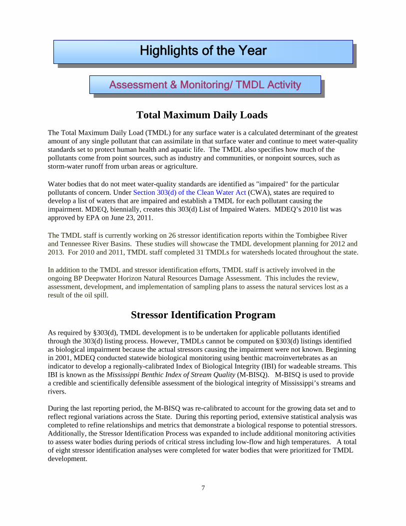
Total Maximum Daily Loads
The Total Maximum Daily Load (TMDL) for any surface water is a calculated determinant of the greatest amount of any single pollutant that can assimilate in that surface water and continue to meet water-quality standards set to protect human health and aquatic life. The TMDL also specifies how much of the pollutants come from point sources, such as industry and communities, or nonpoint sources, such as storm-water runoff from urban areas or agriculture.
Water bodies that do not meet water-quality standards are identified as "impaired" for the particular pollutants of concern. Under Section 303(d) of the Clean Water Act (CWA), states are required to develop a list of waters that are impaired and establish a TMDL for each pollutant causing the impairment. MDEQ, biennially, creates this 303(d) List of Impaired Waters. MDEQ’s 2010 list was approved by EPA on June 23, 2011.
The TMDL staff is currently working on 26 stressor identification reports within the Tombigbee River and Tennessee River Basins. These studies will showcase the TMDL development planning for 2012 and 2013. For 2010 and 2011, TMDL staff completed 31 TMDLs for watersheds located throughout the state.
In addition to the TMDL and stressor identification efforts, TMDL staff is actively involved in the ongoing BP Deepwater Horizon Natural Resources Damage Assessment. This includes the review, assessment, development, and implementation of sampling plans to assess the natural services lost as a result of the oil spill.
Stressor Identification Program As required by §303(d), TMDL development is to be undertaken for applicable pollutants identified through the 303(d) listing process. However, TMDLs cannot be computed on §303(d) listings identified as biological impairment because the actual stressors causing the impairment were not known. Beginning in 2001, MDEQ conducted statewide biological monitoring using benthic macroinvertebrates as an indicator to develop a regionally-calibrated Index of Biological Integrity (IBI) for wadeable streams. This IBI is known as the Mississippi Benthic Index of Stream Quality (M-BISQ). M-BISQ is used to provide a credible and scientifically defensible assessment of the biological integrity of Mississippi’s streams and rivers. During the last reporting period, the M-BISQ was re-calibrated to account for the growing data set and to reflect regional variations across the State. During this reporting period, extensive statistical analysis was completed to refine relationships and metrics that demonstrate a biological response to potential stressors. Additionally, the Stressor Identification Process was expanded to include additional monitoring activities to assess water bodies during periods of critical stress including low-flow and high temperatures. A total of eight stressor identification analyses were completed for water bodies that were prioritized for TMDL development.
Highlights of the Year
Assessment & Monitoring/ TMDL Activity
7

8
Mississippi Benthic Index of Stream Quality
In 2001, MDEQ developed the Mississippi Benthic Index of Stream Quality, Development and Application of the Mississippi Benthic Index of Stream Quality (M-BISQ) (MDEQ 2003b). This Index of Biological Integrity (IBI) is used to assess all wadeable, non-tidal streams in Mississippi with the exception of those located in the Mississippi Alluvial Plain. Monitoring efforts completed have greatly increased the number of biological assessments conducted on State waters. The M-BISQ sampling program and the established sampling and analytical methodology contained therein now serves as the foundation for routine biological monitoring in MDEQ’s statewide Status and Trends Ambient Monitoring Network. The M-BISQ was originally developed using biological and environmental data collected from 463 stream locations. Since 2001, over 1,200 biological samples have been collected from 926 sites. It is a common practice to re-calibrate IBIs every 3-5 years to ensure that the index continues to accurately reflect stream health. As such, in 2008, the M-BISQ was recalibrated using data that were
collected since the original development of the index in 2003. These additional data were used to both test the performance of the original M-BISQ and to recalibrate the index. Over the past several years, MDEQ has been targeting wadeable streams in blackwater systems. Using these data, MDEQ plans to re-calibrate the M-BISQ to test for the applicability of a separate site class for blackwater systems. If successful, this will increase the sensitivity of the index. As part of MDEQ’s routine monitoring program, about 100 samples are scheduled for collection annually. Figure 1 shows all of the M-BISQ monitoring locations where samples have been collected from 2001-2011.
Mississippi Alluvial Plain Monitoring
In 2002, MDEQ began collecting biological, physical, chemical, and habitat data on wadeable streams in the Mississippi Alluvial Plain, commonly referred to as the Mississippi Delta. These data sets, along with historical monitoring in the Mississippi Alluvial Plain, were used to develop a preliminary index of biological integrity for the Mississippi Delta. In addition, the data collected are also being used to evaluate the dissolved oxygen criteria in the Delta as well as support nutrient criteria development. With each new set of data collected annually during September and October, the preliminary index is refined. Once finalized, biological monitoring in the Mississippi Delta will be incorporated into MDEQ’s Ambient Monitoring Program. Since monitoring was initiated in 2002, a total of 96 sites have been monitored. Over the last year, MDEQ has acquired Light Detection and Ranging (LIDAR) data for the Mississippi Alluvial Plain and has been using that data to establish drainage areas for each of the monitoring locations. Once the drainage areas are established, they will be used to perform land-use analyses. These analyses will then be used to refine the preliminary index. The effort to develop an index of biological integrity for the Mississippi Alluvial Plain is an ongoing effort with the USGS.

9
Geographic Information Systems (GIS) and Mapping of NPS Projects
GIS is an integral part of NPS watershed project planning, monitoring, data delivery, and budget tracking. The NPS Branch uses many GIS tools to accomplish these tasks, but this section will focus on three applications: 1) The Mississippi Watershed Characterization and Ranking Tool (MWCRT); 2) The Mississippi Water Quality Data Compendium; and 3) The NPS Watershed Resource Management System (WRMS). In support of these tools, the NPS program maintains a geodatabase of locational information for all current and historical Best Management Practice (BMP) installations and also stores information regarding assessment and monitoring of NPS projects.
MWCRT
The MWCRT is a spatially-based tool used to characterize and rank all 10- and 12-Digit HUCs, watersheds and subwatersheds, respectively, for all major river basins in Mississippi. The data within the MWCRT are summarized and assessed to characterize each of those watersheds and subwatersheds. For the characterization(s), data layers are placed into two major categories based on whether the layer is deemed to have resource value (environmental or human welfare, respectively), or whether it places potential stress on a subwatershed. Next, data are calculated as observations (counts), linear miles, and acres on the subwatershed level and normalized using a linear-transform equation. The normalized data are weighted by relative importance to create the ranking system. Each data layer can then be assessed individually or combined to drive the output from the MWCRT (Figure 1). The MWCRT provides a scientific method to allow managers to identify watersheds of interest, make meaningful decisions, and prioritize watersheds for restoration and protection activities. Ultimately, the tool has shortened evaluation times for identifying priority watersheds. For 2011, the MWCRT has been updated to include the 2006 National Landuse Classification Dataset (NLCD), Certified Watershed Boundary Dataset (WBD, 2006), and cropland National Agriculture Statistic Service Cropland Data (NASS CDL), 2009).
Mississippi Water Quality Data Compendium
In 2011, the NPS Branch supported the development of the Mississippi Water Quality Data Compendium (The Compendium). The Compendium was developed in an effort to coordinate a wide variety of data collection activities and improve inter-agency communication and coordination concerning water-quality data collection among the U.S. Army Corps of Engineers (USACE), U.S. Geological Survey (USGS), and the Mississippi Department of Environmental Quality (MDEQ). The Mississippi Water Quality Data Compendium is a web-based GIS application that shows the location of data collection sites or projects and provides a description of the data including contact

information to obtain necessary water-quality data. The Compendium includes information on the existing water-quality data in a simple user-friendly interface.
The goal(s) of The Compendium are: · Foster increased access and use of the existing data; · Identify gaps and/or overlaps in data collection; · Promote collaboration and coordination of monitoring activities to improve data collection planning and maximize efficient use of available resources; · Establish a sustainable process to routinely update the data compendium; and · Improve natural resource management.
Data sets are categorized, described, listed and geographically queried and served to users. The Compendium also provides the ability to zoom to a specific area and query filter out all the available water- quality data in the specified area. The user will also be able to generate reports and maps. In addition, The Compendium provides website links for additional information and brief descriptions of each project partner’s data layers are listed below: Data Search Layers MDEQ Data: Point Source Permits, Stormwater Permits, Section 319 BMP Sites, enSPIRE Sites USACE Data: Yazoo Basin Sites USGS Data: Real-Time Water Quality Sites, Real-Time Stream Flow, Surface Water Quality after 1980, Surface Water Quality before 1980, Groundwater Quality Sites Background Layers 303d Impaired Waters, Drainage Areas, NLCD 2001 Landuse, Water Designated Uses Click on the link below to access the data compendium: Mississippi Water Quality Data Compendium
WRMS
Water Resources Management System (WRMS) is a custom implementation of Watershed-The System, an extensive GIS-enabled solution developed by Cengea Solutions, Inc (Cengea). The NPS Program contracted Cengea to develop WMRS to help meet its grant tracking obligations. The NPS Management Branch uses WRMS to enter, manage, map, analyze, and report information about the NPS 319 program, budget, and activities. The system contains many modules but seven modules are used by the NPS Program. The modules are: 1) Cooperators; 2) Planner; 3) Watershed Projects; 4) Cooperator Projects; 5) Fund Manager; 6) Map and; 7) Reporting Modules. The WRMS takes a project-driven approach. It takes funds granted using the Fund Manager Module and passes them into projects in the Watershed Projects and Cooperator Projects modules. NPS staff uses the Fund Manager Module to record MDEQ Division Codes (DCs). The DCs then allocate 319 Grant funds to the NPS Program. The Watershed Projects Module is used to move DC funds into NPS Program work-element projects. These projects are organized around the grant-budget work elements. Projects in the Watershed Module are usually planning accounts for money awarded and spent through contracts or agreements with external parties (Cooperator Projects). The Cooperator Projects Module consists of projects that are usually sub-grant awards or contracts let to State agencies or other entities (third parties) with NPS pollution-control goals and objectives similar to the MDEQ NPS Program. MDEQ awards money for a cooperator project within the WRMS in which a third party has agreed to perform the work. When the work is completed, the third party is reimbursed for the effort. WRMS is used to track these activities and their funding.
10

The Cooperators Module holds a list of organizations and contacts involved with activities of the NPS Management Branch. MDEQ communicates with project contractors or partnering agencies who, in turn, will communicate with members of the public that also participate in projects by various means. Activities include constructing or maintaining BMPs, education/outreach events, water-quality monitoring or assessments, to name a few. The Planner Module allows users of the application to create and manage a set of goals and objectives for the NPS Program. The Map Module uses a GIS service to view surface features in Mississippi and record or see and analyze where NPS Program activities have taken place. Finally, the Reporting Module is used to run either canned reports or ad hoc reports from queries run against data in the WRMS (Figure 2).
Figure 1. Map of Buttahatchee River MWCRT Potential Stressors Output.
11

Figure 2. GIS mapping shows locations of BMPs in the Buttahatchee River Watershed.
12
Mississippi Agricultural Chemical Groundwater Monitoring Program
The Mississippi Agricultural Chemical Groundwater Monitoring Program is an on going program initiated in March, 1989, for the purpose of determining if the use of agricultural chemicals is impacting groundwater quality in Mississippi. During the calendar year 2011, 41 samples have been collected from a total of 39 sources. Included in this total were 28 drinking water samples, and 13 irrigation, fish culture or wild-life management samples. The program remains committed to testing wells located in the highly agriculturalized Mississippi Delta. One sample of the 41 analyzed detected a compound in excess of Federal Primary Drinking Water Standards. Dichlorophenoxyacetic Acid (2,4-D) was reported at 0.3700 ug/L. Believing this to be an erroneous analysis or otherwise faulty sample, the well was resampled twice following the initial detect, with both subsequent resamples reporting 0.0000 (No Detect) for the 2,4-D compound. As an additional precautionary measure, there will be follow-up analyses in calendar year 2012. Analyses of the other 38 samples performed by the Ag-Chem program did not detect any agricultural chemicals or other organic compounds exceeding Federal Primary Drinking Water Standards and/or State of Mississippi Groundwater Standards. In addition to monitoring groundwater for harmful compounds, the AgChem Program actively participates in other programs involved in protecting groundwater in Mississippi. One of these programs is the Mississippi Pesticide Container Recycle Program. During the calendar year 2011, a total of three days have been spent out of the office for field activities related to this program. Although complete amounts are not yet available, it is estimated that a total of over 550,000 pounds of plastic pesticide containers will be recycled during this calendar year. Another area in which the AgChem Program participates is the Mississippi Waste Pesticide Disposal Program. During the calendar year 2011, four days were spent in field activities related to this program through which a cumulative total of more than 67,888 pounds of waste pesticides have been collected.
Supplemental Watershed Implementation Project Monitoring
MDEQ continues to maintain a supplemental monitoring agreement with the U.S. Geological Survey (USGS). Each agency shares 50 percent of the costs with §319 NPS funds contributing its share to develop pre- and post-implementation monitoring plans in priority watersheds. The monitoring aids in quantifying water-quality improvements over time. These plans are developed in collaboration with local Watershed Implementation Teams and serve as the monitoring component of the respective Watershed Implementation Plan. Development of a Quality Assurance Project Plan (QAPP) for each monitoring plan is also required. The recurring annual agreement calls for approximately $255,000 from each participating organization. Where possible, funding for the actual implementation of the monitoring plan will be included in the incremental §319 NPS contract for each project. Monitoring is ongoing in: Harris and Porter Bayous and Bee Lake. Monitoring reports are being developed for Twentymile/Donivan/Casey Creeks and Mill Creek.
13
14
$2,900,000
$3,000,000
$3,100,000
$3,200,000
$3,300,000
$3,400,000
$3,500,000
$3,600,000
$3,700,000
$3,800,000
Aw
ard
Am
ount
06 07 08 09 10 11
Fiscal Year
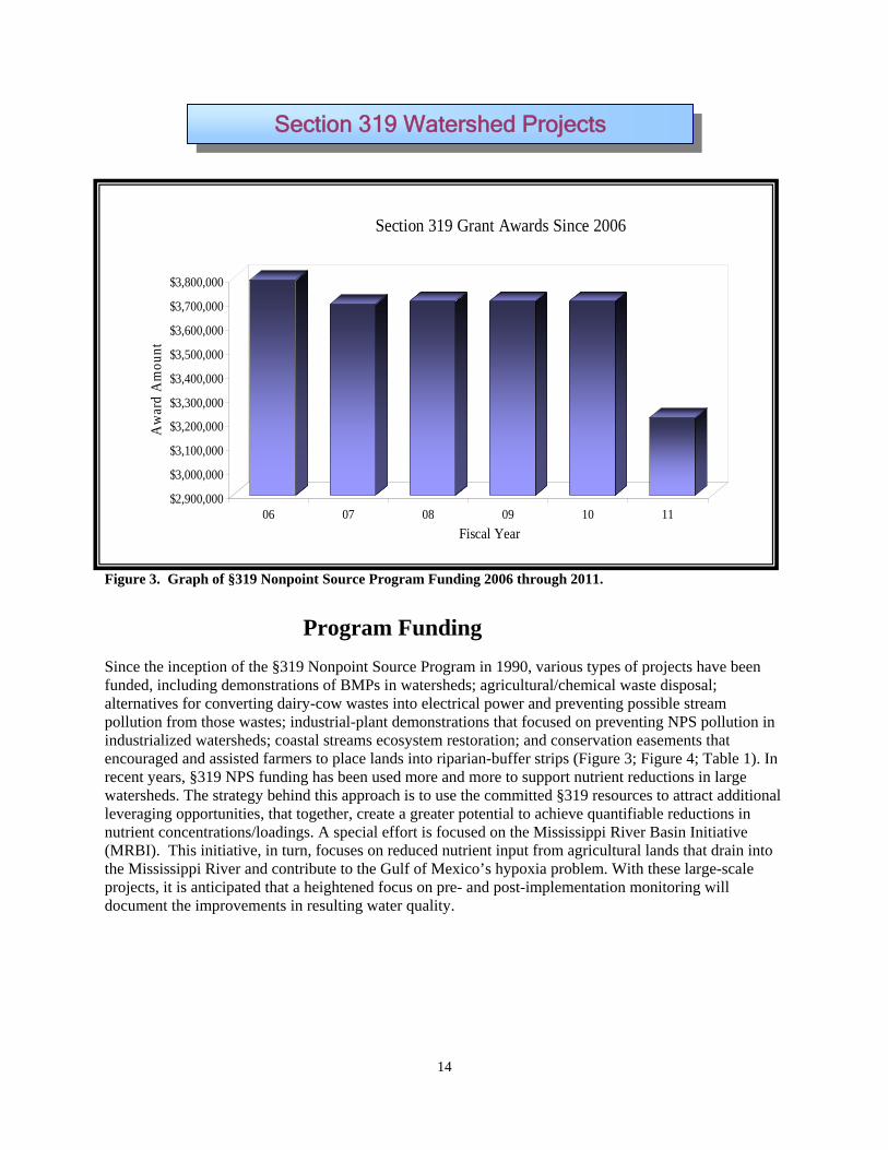
Section 319 Grant Awards Since 2006
funded, including demonstrations of BMPs in watersheds; agricultural/chemical waste disposal; alternatives for converting dairy-cow wastes into electrical power and preventing possible stream pollution from those wastes; industrial-plant demonstrations that focused on preventing NPS pollution in industrialized watersheds; coastal streams ecosystem restoration; and conservation easements that encouraged and assisted farmers to place lands into riparian-buffer strips (Figure 3; Figure 4; Table 1). In recent years, §319 NPS funding has been used more and more to support nutrient reductions in large watersheds. The strategy behind this approach is to use the committed §319 resources to attract additional leveraging opportunities, that together, create a greater potential to achieve quantifiable reductions in nutrient concentrations/loadings. A special effort is focused on the Mississippi River Basin Initiative (MRBI). This initiative, in turn, focuses on reduced nutrient input from agricultural lands that drain into the Mississippi River and contribute to the Gulf of Mexico’s hypoxia problem. With these large-scale projects, it is anticipated that a heightened focus on pre- and post-implementation monitoring will document the improvements in resulting water quality.
Figure 3. Graph of §319 Nonpoint Source Program Funding 2006 through 2011.
Program Funding
Since the inception of the §319 Nonpoint Source Program in 1990, various types of projects have been
Section 319 Watershed Projects

Firgure 4. Locations of watershed projects in Mississippi since the NPS program’s inception. An index of all the numbered locations is shown on the following two pages.
15

Table 1. Index of all the numbered project locations since 1990.
Wastershed Projects Project Name
1 1990 Lake Hazle 2 1990 Swine Production Waste Management 3 1992 Bogue Chitto Watershed 4 1992 Lake Washington 5 1993 Luxipalila Watershed 6 1993 NPS Demo Farm 7 1993 NPS Demo Farm 8 1994 Muddy Creek Demo 9 1994 Okatoma Creek Demo
10 1995 Catfish Pond Nutrient Removal 11 1995 Irrigation Return Flow Water Quality Demo 12 1995 McIvor Creek Watershed 13 1995 Surface Water/Groundwater Interaction 14 1995 Wolf lake NPS Demo 15 1996 Copiah-Lincoln Golfcourse BMP Demo 16 1996 Impact of Flooding on Nitrogen Discharge (Roebuck Lake) 17 1996 Moon Lake Demo 18 1996 Urban Resource Conservation Plan, Madison 19 1997 Cane Musscacunna Creeks 20 1997 Land Acquisition 21 1997 Model Stormwater BMP Demo - Lefleur's Bluff 22 1997 Pushepatapa Watershed 23 1998 MSEA (Beasley Lake) Project 24 1998 MSEA (Deep Hollow Lake) Project 25 1998 Souinlovey Creek 26 1998 Ten Mile Creek Demo 27 1998 Ten Mile/Donivan Creek 28 1998 Upper Bogue Phalia Watershed 29 1999 Coastal Streams 30 1999 Delta F.A.R.M. Project 31 1999 East Fork Amite River Watershed 32 1999 MSEA (Thigman Lake) Project 33 2000 Alternative BMPs in Bogue Phalia 34 2000 Big Cypress Creek 35 2000 Bogue Phalia/ Coldwater River Watershed 36 2000 Mound Bayou 37 2000 MSVU Water Quality Demo 38 2000 Riverdale Creek 39 2001 Cane - Duncans Watershed Demo 40 2001 Lower Pearl River Watershed Demo 41 2001 Luxapalila/Yellow Creek Watershed Demo 42 2001 Middle/West Bowie Creek Watershed Demo 43 2001 Old Fort Bayou
16
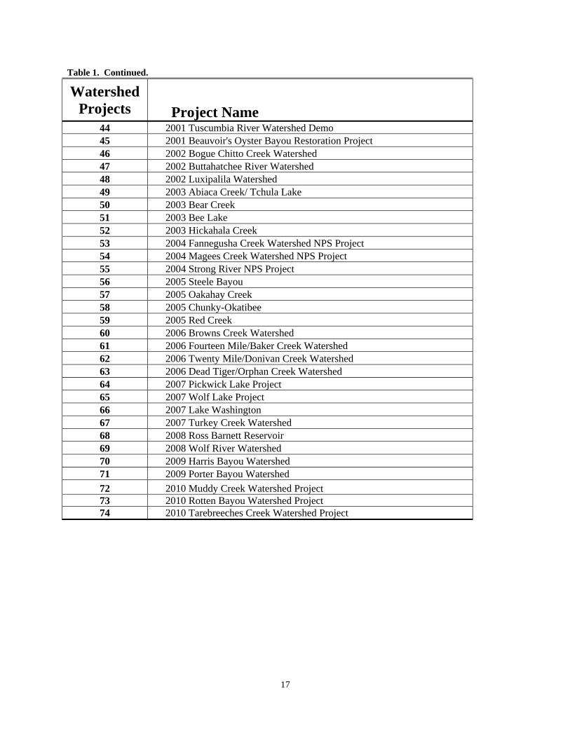
Table 1. Continued.
Watershed Projects Project Name
44 2001 Tuscumbia River Watershed Demo 45 2001 Beauvoir's Oyster Bayou Restoration Project 46 2002 Bogue Chitto Creek Watershed 47 2002 Buttahatchee River Watershed 48 2002 Luxipalila Watershed 49 2003 Abiaca Creek/ Tchula Lake 50 2003 Bear Creek 51 2003 Bee Lake 52 2003 Hickahala Creek 53 2004 Fannegusha Creek Watershed NPS Project 54 2004 Magees Creek Watershed NPS Project 55 2004 Strong River NPS Project 56 2005 Steele Bayou 57 2005 Oakahay Creek 58 2005 Chunky-Okatibee 59 2005 Red Creek 60 2006 Browns Creek Watershed 61 2006 Fourteen Mile/Baker Creek Watershed 62 2006 Twenty Mile/Donivan Creek Watershed 63 2006 Dead Tiger/Orphan Creek Watershed 64 2007 Pickwick Lake Project 65 2007 Wolf Lake Project 66 2007 Lake Washington 67 2007 Turkey Creek Watershed 68 2008 Ross Barnett Reservoir 69 2008 Wolf River Watershed 70 2009 Harris Bayou Watershed 71 2009 Porter Bayou Watershed
72 2010 Muddy Creek Watershed Project 73 2010 Rotten Bayou Watershed Project 74 2010 Tarebreeches Creek Watershed Project
17

Numeric Nutrient Criteria Development
In 2011, MDEQ continued development of numeric nutrient criteria for Mississippi’s various water body types. MDEQ’s mission is to develop scientifically defensible criteria that are appropriate and protective of Mississippi’s waters. The criteria for each water body type will be coordinated with other water body types to ensure consistency across the state and protection from downstream impacts. Highlights of MDEQ’s numeric nutrient criteria development efforts within 2011 include: The Mississippi Nutrient Technical Advisory Group (TAG) held three meetings in 2011. The mission of the MS Nutrient TAG is to provide technical expertise and regional knowledge to MDEQ for the development of scientifically defensible numeric nutrient criteria. The TAG consists of over 30 members representing multiple state and federal agencies, and four of Mississippi’s universities. The 2011 TAG meetings focused on providing continued technical input on developing nutrient criteria for Mississippi’s wadeable and non-wadeable streams, Mississippi’s lakes and reservoirs, and Mississippi’s coastal and estuarine waters. MDEQ continues data analyses efforts based on recommendations from the TAG. The Mississippi TAG will continue to meet quarterly throughout the criteria development process to help MDEQ meet the timeline and schedule of Mississippi’s Nutrient Criteria Development Plan. Mississippi’s Nutrient Criteria Development Plan outlines the process and timeline the state intends to follow to numeric nutrient criteria. This plan was mutually agreed upon by the state and EPA in October 2010. Nutrient criteria are being developed based on water body type and are divided into the categories of (1) wadeable streams, (2) non-wadeable streams, (3) MS Delta waters, (4) lakes and reservoirs, and (5) coastal and estuarine waters. The timeline is mutually agreed upon by EPA and was revised to incorporate results from ongoing efforts within our state. The public comment period will begin by June 30, 2013 for lakes and reservoirs, wadeable streams, non-wadeable streams, and coastal and estuarine waters. The public comment period will begin on November 30, 2014 for MS Delta waters. MDEQ is currently on track with the timelines in this plan. Mississippi continues to make progress successfully implementing our plan. All milestones within the Nutrient Criteria Development Plan for 2011 were met.
Nutrient Reduction Strategy
The Mississippi River/Gulf of Mexico Hypoxia Task Force, as well as the Gulf of Mexico Alliance, has issued Action Plans that include reducing excess nutrient loadings to the Gulf of Mexico through the development and implementation of state nutrient reduction strategies. Mississippi’s approach to reduce nutrient loadings within basins and to the Gulf of Mexico is a highly collaborative, stakeholder-supported process centered on the development and implementation of comprehensive nutrient reduction strategies for nonpoint and point sources of pollution. The approach is also built upon nutrient TMDLs developed under EPA’s Federal Consent Decree. To implement these plans successfully, over 20 state- and federal-resource agencies, nongovernmental stakeholder organizations, and local watershed teams in Mississippi are working together to develop and implement nutrient reduction strategies. Mississippi has been a leader in the development and implementation of nutrient reduction strategies, first for the Delta region, and subsequently for the Uplands and Coastal Regions. The strategies are being developed using an approach that fosters local stakeholder involvement, addresses varying land uses among regions, and maximizes regional partnering and leveraging opportunities. These three regional nutrient reduction strategic plans have been integrated into this Mississippi Nutrient and Associated Pollutant Reduction Strategic Implementation Plan. This integration allows development and implementation of consistent, compatible, and coordinated watershed management plans across the state while addressing the distinct regional differences that exist for nutrient sources of the State.
18

Basin Management Approach Basin Group 1 (Tombigbee River, Tennessee River, and North Independent Streams) The biggest project for this basin team was the restoration and protection activities in Pickwick Lake Watershed in the Tennessee River Basin. This project is located in an EPA, Region 4 priority watershed. The Pickwick Lake Watershed Team, under the leadership of the Tennessee Valley Authority (TVA), has implemented a multi-faceted Watershed Plan for the Bear, Yellow, and Indian Creek watersheds. The team was composed of 11 partners including the U. S. Environmental Protection Agency, Region 4; Geological Survey of Alabama; MDEQ; Mississippi Department of Health; Mississippi Forestry Commission; Mississippi Rural Water Association; Mississippi Soil & Water Conservation Commission (MSWCC) and Conservation Districts; USDA-Natural Resources Conservation Service; The Nature Conservancy-Mississippi Chapter; U. S. Fish & Wildlife Service; and TVA. Some of these agencies worked directly with landowners; others conducted monitoring and helped with education and outreach. The third annual Secchi Day monitoring/education and outreach day was held in September 2011. In the fall of 2010, the team conducted a Septic System seminar and voucher pump-out program that was very well received. To prevent NPS pollution from agricultural sources at the Pickwick Project, 237 BMP practices were installed, 2,137 acres were affected and an estimated 23,950 tons of soil savings per year were achieved. In addition to retaining valuable topsoil, the project protected water quality in Bear and Yellow creeks. Watershed restoration projects for Donivan, Twentymile, and Browns creeks in the Tombigbee River Basin also have been completed. In the Donivan/Twentymile project, 141 BMPs have been installed to restore and protect water quality. Six-hundred-fifty feet of diversions, 14,952 feet of fencing and 1,356 feet of streambank and shoreline protection were installed. Other practices affected 847 acres and account for an estimated total soil savings of 29,252 tons per year. The Browns Creek watershed restoration and protection project included 78 BMP practices, saved an estimated 8,190 tons of soil, and improved water quality. The economic downturn limited landowners’ participation in this watershed more so than in the other watersheds. Basin Group 2 (Yazoo River) is the focus of several, large-scale watershed projects designed to implement nutrient and sediment TMDLs. Objectives of these projects include implementation of the Mississippi Delta Nutrient Reduction Strategies to answer the following key questions:
What nutrient load reductions are achievable? What will these reductions cost? What is the value to each stakeholder from these reductions? How can these strategies be best implemented in the future?
The selected watersheds for implementation of the Delta Nutrient Reduction Strategies include Harris Bayou, Porter Bayou, Bee Lake, Lake Washington, Wolf/Broad Lake, and Steele Bayou. The Harris Bayou, Porter Bayou, and Bee Lake (Phase II) nutrient-reduction implementation projects are currently ongoing. These projects provide useful information for the ongoing nutrient-criteria development effort. Significant leveraging of non-319 resources has been directed toward these projects. Edge of field (Tier 1), instream (Tier 2), and downstream integrator (Tier 3) monitoring sites are active in the Harris Bayou and Porter Bayou watersheds. MDEQ, USGS, Mississippi State University (MSU), and Delta Wildlife are monitoring flow, sediment, Nitrogen (N), Phosphorous (P), and other constituents during both base flows and storm flows. Monitoring is being conducted prior to, and after construction
19

20
and implementation of conservation BMPs to determine the resulting percent reduction in each of these constituents. Edge-of-field sites and sites above and below weirs in ditches have been established to monitor discharge and constituent concentration, so that load reductions can be estimated. Stream gages are also established at downstream water-quality monitoring sites so the cumulative effectiveness of BMPs in reducing sediment, N, and P concentrations can be estimated. For the Bee Lake Phase II Project, the USGS has been collecting nutrient data from a tributary site since March of 2010; installation of conservation BMPs will begin in 2012. Harris Bayou, Porter Bayou, Bee Lake, Lake Washington, and Steele Bayou are EPA-priority watersheds. Other completed watershed projects using 319 NPS funding include Hickahala Creek, Senatobia Creek, Tchula Lake–Abiaca Creek, and Deer Creek.
Basin Group 3 (Pearl River, Big Black River and South Independent Streams) has realized significant attention through the planning activities of the Ross Barnett Reservoir Initiative now known as “Rezonate! Your Water...Your Legacy”. Rezonate was designed to build public awareness about the environmental impacts of activities within the Ross Barnett Reservoir watershed, educate stakeholders about the absolute importance of protecting and restoring the water quality of the Reservoir, and involve local stakeholders in restoration and protection activities within the watershed. The planning and development stages of the initiative were funded by GY09 NPS funds. At present, five plans have been developed for Rezonate. These plans have been completed and will provide guidance for implementation in the watershed. Due to the massive size of the Reservoir Watershed, four targeted subwatersheds have been selected to begin initial implementation projects. These subwatersheds include: 1) Mill-Pelahatchie Creek located entirely in Rankin County adjacent from Pelahatchie Bay; 2) Ashlog-Pelahatchie Creek located in the headwaters of Pelahatchie Creek within Rankin and Scott Counties; 3) Riley-Pelahatchie Creek located in Rankin County and contains some development from the outskirts of Flowood and Fannin and; 4) Lake Creek-Pearl River located upstream of the Reservoir between Ratliff Ferry and the Low Head Dam, a section of the Pearl River used extensively for recreation.
Basin Group 4 (Pascagoula River, and Coastal Streams) has received the emphasis of more protection-oriented watershed projects. These projects have focused on the acquisition of conservation easements and have also included installation of BMPs at Turkey Creek, Oakahay Creek, Dead Tiger/Orphan Creek, Pascagoula and Escatawpa Rivers, Red Creek, Chunky River, and Okatibbee Creek/Lake. Turkey Creek is an EPA- and MDEQ-priority watershed. The projects are currently in the implementation phase. Wolf River has recently completed a Watershed Implementation Plan that includes Protection and Restoration and Education and Outreach Projects. A Coastal Nutrient Reduction Strategy has been developed by MDEQ and their partners. The Nutrient Reduction Strategy is now being implemented through a watershed project in Rotten Bayou, a tributary to the Jourdan River and St. Louis Bay. The second annual Battle on the Bayou was held on the Old Fort Bayou Blueway, where 188 canoes and kayaks paddled down a 9½-mile trail. Blueways, which are paddling trails on waterways, have now been developed on Old Fort Bayou, the Pascagoula and Jourdan
Rivers, and on Red Creek. Blueways are planned for Turkey Creek and the Wolf River.

21
MDEQ had six active grants in 2011 totaling $22.2 million in federal funds. During 2011, 49 projects/activities totaling $7.4 million were completed with 23 projects/activities still ongoing. Those that are ongoing may take from one to four years to complete. The following is a highlight of some of those projects.
Porter Bayou and Harris Bayou Nutrient Reduction Projects
The 66,405-acre Porter Bayou Watershed is located in Bolivar and Sunflower Counties, Mississippi. The watershed is comprised predominately of productive agricultural lands making up nearly 56,000 acres (82%) and urban areas making up only 3,882 acres (5.8%) of the total watershed area.
The 71,592-acre Harris Bayou Watershed is located in Bolivar and Coahoma Counties, Mississippi. The watershed is comprised predominately of productive agricultural lands making up nearly 57,000 acres (79.4%) and urban areas making up only 5,201 acres (7.3%) of the total watershed area.
Showcased Section 319 Projects
22
Harris Bayou and Porter Bayou are examples of leveraging resources in a collaborative effort within the purview of the Mississippi River Basin Initiative (MRBI) The MRBI’s goal is to implement nutrient reduction strategies in the Delta and includes the efforts of MDEQ, USDA Natural Resources and Conservation Service (NRCS), United States Geological Survey (USGS), other federal and state agencies, and local farmers. These agencies leveraged resources to initiate the projects. The main objectives of these nutrient reduction projects are to accurately determine what reductions are achievable using BMPs and the cost to implement these practices. These objectives are being accomplished by educating local farmers with the following: 1) management practices that reduce nutrient input; 2) innovative farming practices and: 3) other measures that include installing vegetative and structural BMPs such as low-grade
h , a high
plemen in thrien
Project
rural as it
k River Canal watershed which is a
weirs, constructed-treatment wetlands, grade-control steducation and implementation of these practicesbeing equipped with the necessary tools to imfrom generation to generation. The USGS has imdocument the nutrient reduction and water qualityhas been collected, analytical models to project nutcreated in order to achieve the primary goals.
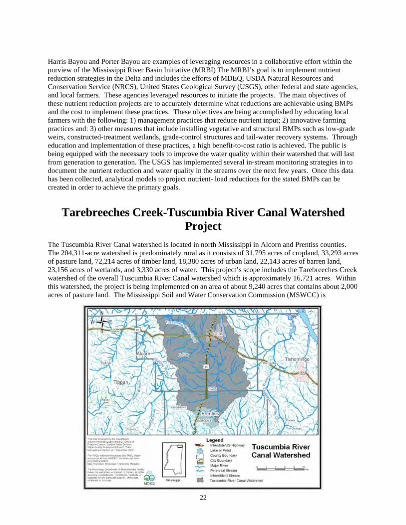
Tarebreeches Creek-Tuscum
The Tuscumbia River Canal watershed is located in The 204,311-acre watershed is predominatelyof pasture land, 72,214 acres of timber land, 18,38023,156 acres of wetlands, and 3,330 acres of water. watershed of the overall Tuscumbia this watershed, the project is being implemented on anacres of pasture land. The Mississippi Soil and Water Conservation
ructures and tail-water recovery systems. Througbenefit-to-cost ratio is achieved. The public is
prove the water quality within their watershed that will last ted several in-stream monitoring strategies in to
e streams over the next few years. Once this data t- load reductions for the stated BMPs can be
bia River Canal Watershed
north Mississippi in Alcorn and Prentiss counties. consists of 31,795 acres of cropland, 33,293 acres
acres of urban land, 22,143 acres of barren land, This project’s scope includes the Tarebreeches Cree
pproximately 16,721 acres. Within area of about 9,240 acres that contains about 2,000
Commission (MSWCC) is
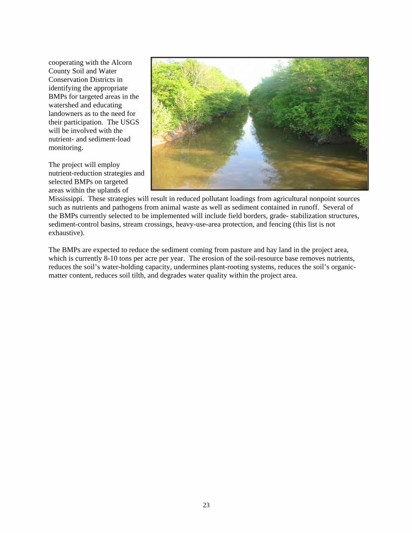
cooperating with the Alcorn County Soil and Water Conservation Districts in identifying the appropriate BMPs for targeted areas in the watershed and educating landowners as to the need for their participation. The USGS will be involved with the nutrient- and sediment-load monitoring. The project will employ nutrient-reduction strategies and selected BMPs on targeted areas within the uplands of Mississippi. These strategies will result in reduced pollutant loadings from agricultural nonpoint sources such as nutrients and pathogens from animal waste as well as sediment contained in runoff. Several of the BMPs currently selected to be implemented will include field borders, grade- stabilization structures, sediment-control basins, stream crossings, heavy-use-area protection, and fencing (this list is not exhaustive). The BMPs are expected to reduce the sediment coming from pasture and hay land in the project area, which is currently 8-10 tons per acre per year. The erosion of the soil-resource base removes nutrients, reduces the soil’s water-holding capacity, undermines plant-rooting systems, reduces the soil’s organic-matter content, reduces soil tilth, and degrades water quality within the project area.
23
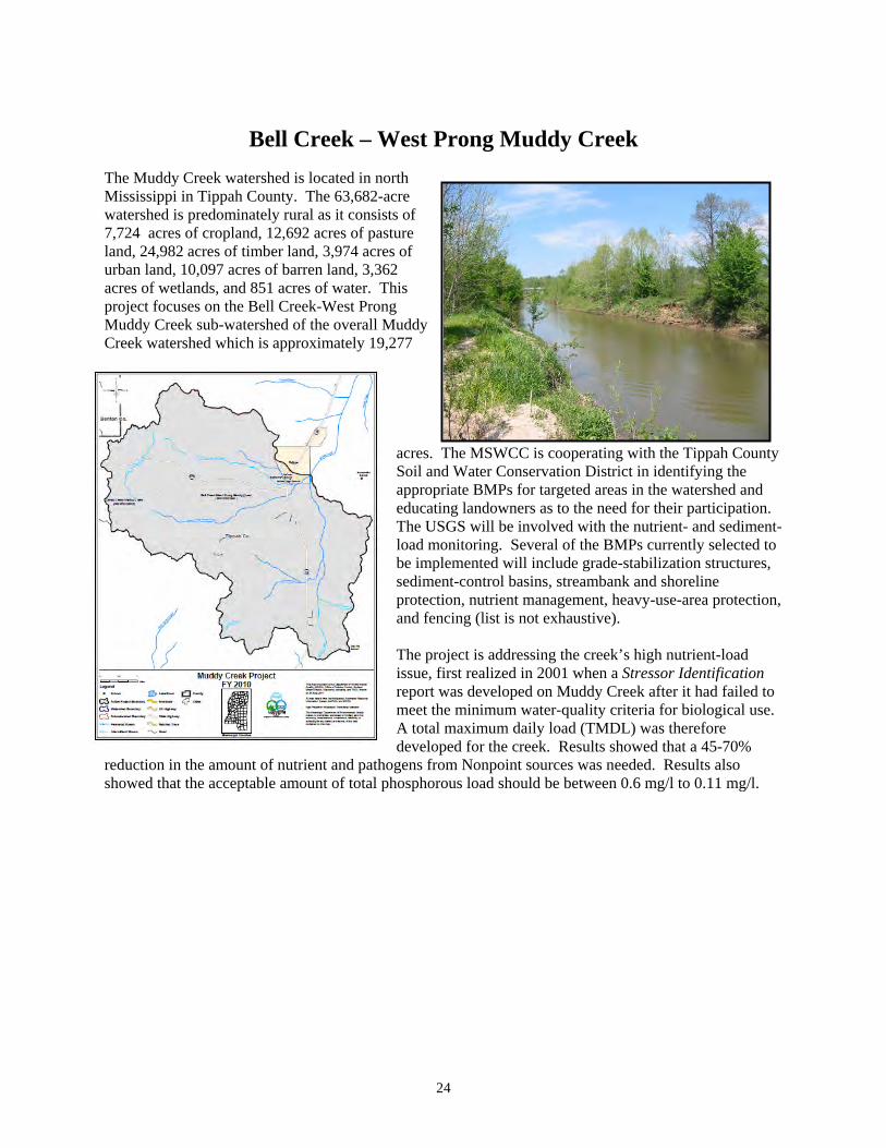
Bell Creek – West Prong Muddy Creek The Muddy Creek watershed is located in north Mississippi in Tippah County. The 63,682-acre watershed is predominately rural as it consists of 7,724 acres of cropland, 12,692 acres of pasture land, 24,982 acres of timber land, 3,974 acres of urban land, 10,097 acres of barren land, 3,362 acres of wetlands, and 851 acres of water. This project focuses on the Bell Creek-West Prong Muddy Creek sub-watershed of the overall Muddy Creek watershed which is approximately 19,277
acres. The MSWCC is cooperating with the Tippah County Soil and Water Conservation District in identifying the appropriate BMPs for targeted areas in the watershed and educating landowners as to the need for their participation. The USGS will be involved with the nutrient- and sediment- load monitoring. Several of the BMPs currently selected to be implemented will include grade-stabilization structures, sediment-control basins, streambank and shoreline protection, nutrient management, heavy-use-area protection, and fencing (list is not exhaustive).
70% reduction in t s also
g/l.
The project is addressing the creek’s high nutrient-load issue, first realized in 2001 when a Stressor Identificationreport was developed on Muddy Creek after it had failed to meet the minimum water-quality criteria for biological use. A total maximum daily load (TMDL) was therefore developed for the creek. Results showed that a 45-
he amount of nutrient and pathogens from Nonpoint sources was needed. Resultshowed that the acceptable amount of total phosphorous load should be between 0.6 mg/l to 0.11 m
24

Rotten Bayou Rotten Bayou Watershed Agricultural Nonpoint Pollution Control Project
The Rotten Bayou watershed is located in south Mississippi in Hancock and Harrison counties. The 22,446-acre watershed is predominately rural as it consists of 25% pasture land, 50% timber, and 25% other lands. The MSWCC is cooperating with both the Hancock and Harrison County Soil and Water Conservation Districts in identifying the appropriate BMPs for targeted areas in the watershed and educating landowners as to the need for tand sediment-load monitoring. Several tree and shrub establishmenbasins, nutrient management, heavprotection, and fencing.
The project will employ nutrient-reduction strategies and selected BMPs on targeted areas within the coastal lands of Mississippi. These strategies will demonstrate the economic benefits and effectiveness of BMPs as well as obtain the desired outcome of reduced runoff, limited cattle access to the streams, and reduced nutrient and sediment pollution. Also, the project will inform and educate the public about BMPs to improve the quality of our State’s waters. Soils in this particular watershed are highly erosive as sheet and rill erosion are occurring resulting in five (5) tons of sediment loss per acre per year across the pasture land. Pollutant-load reduction data will be gathered, recorded, and used to determine the overall effectiveness of each BMP. Each participant that is associated with the individual BMPs will continue to maintain that BMP for a period of up to ten years after installation.
heir participation. The USGS will be involved with the nutrient- of the BMPs currently selected to be implemented will include
t on forest-harvest trails and landings, vegetative barriers, sediment-control y-use-area
25
26
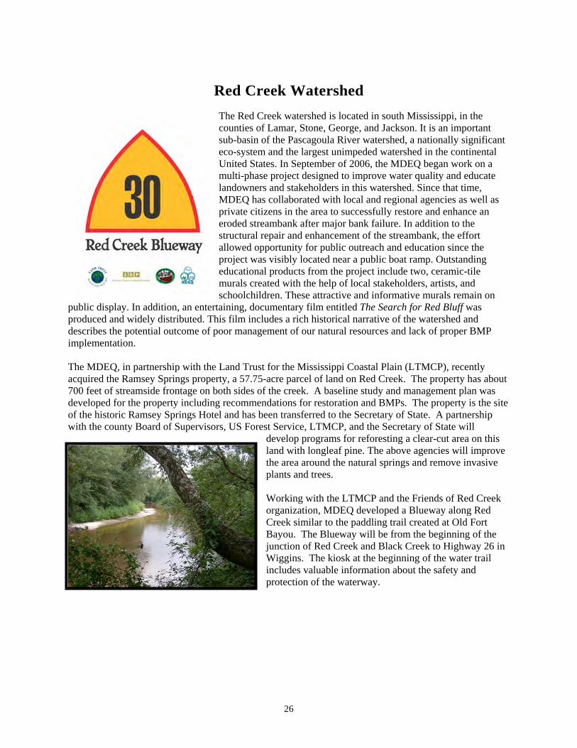
Red Creek Watershed
The counties of Lamsub-basin of theco-system aUnited States. In Septemmulandowners and stakeholdeMDEQ has co
eroded streambstructural repair and enhanceallowed opportunitproject was visibl
reated
schoolchildren. These attractive and informative murals remain on entary film entitled The Search for Red Bluff was
includes a rich historical narrative of the watershed and management of our natural resources and lack of proper BMP
Trust for the Mississippi Coastal Plain (LTMCP), recently
a 57.75-acre parcel of land on Red Creek. The property has about des of the creek. A baseline study and management plan was
recommendations for restoration and BMPs. The property is the site ansferred to the Secretary of State. A partnership
Service, LTMCP, and the Secretary of State will develop programs for reforesting a clear-cut area on this land with longleaf pine. The above agencies will improve the area around the natural springs and remove invasive plants and trees. Working with the LTMCP and the Friends of Red Creek organization, MDEQ developed a Blueway along Red Creek similar to the paddling trail created at Old Fort Bayou. The Blueway will be from the beginning of the junction of Red Creek and Black Creek to Highway 26 in Wiggins. The kiosk at the beginning of the water trail includes valuable information about the safety and protection of the waterway.
Red Creek watershed is located in south Mississippi, in the ar, Stone, George, and Jackson. It is an important
e Pascagoula River watershed, a nationally significant nd the largest unimpeded watershed in the continental
ber of 2006, the MDEQ began work on a lti-phase project designed to improve water quality and educate
rs in this watershed. Since that time, llaborated with local and regional agencies as well as
private citizens in the area to successfully restore and enhance an ank after major bank failure. In addition to the
ment of the streambank, the effort y for public outreach and education since the
y located near a public boat ramp. Outstanding oducts from the project include two, ceramic-tile with the help of local stakeholders, artists, and
educational pmurals cr
public display. In addition, an entertaining, documproduced and widely distributed. This filmdescribes the potential outcome of poor implementation.
The MDEQ, in partnership with the Landacquired the Ramsey Springs property, 700 feet of streamside frontage on both sideveloped for the property includingof the historic Ramsey Springs Hotel and has been trwith the county Board of Supervisors, US Forest
27
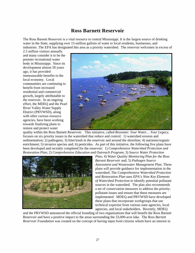
Ross Barnett Reservoir The Ross Barnett Reservoir is a vital resource to central Mississippi. It is the largest source of drinking water in the State, supplying over 15-million gallons of water to local residents, businesses, and industries. The EPA has designated this area as a priority watershed. The reservoir welcomes in excess of 2.5 million visitors annually and many consider it to be the premier recreational water body in Mississippi. Since its development almost 50 years ago, it has provided immeasurable benefits to the local economy. Local communities are continuing to benefit from increased residential and commercial growth, largely attributable to the reservoir. In an ongoing effort, the MDEQ and the Pearl River Valley Water Supply District (PRVWSD), along with other various resource agencies, have been working towards finalizing plans to restore and protect water quality within the Ross Barnett Reservoir. This initiative, called focuses on six priority issues in the watershed thatsedimentation; 2) pathogens; 3) litter/trash in the reserenrichment; 5) invasive species and; 6) pesticides. Asbeen developed and recently completed for the reservoir: 1) Restoration Plan; 2) Comprehensive Education and Outreach
Plan
watershed. The Comprehensive Watershed Protection and Restoration Plan uses EPA’s Nine Key Elements of Watershed Protection to identify potential pollutant sources in the watershed. The plan also recommends a set of conservation measures to address the priority-pollutant issues and ensure that these measures are implemented. MDEQ and PRVWSD have developed these plans that incorporate workgroups that use technical expertise from various state agencies, local agencies, and local stakeholders. Recently, MDEQ
and the PRVWSD announced the official founding of two organizations that will benefit the Ross Barnett Reservoir and have a positive impact to the areas surrounding the 33,000-acre lake. The Ross Barnett Reservoir Foundation was created on the concept of having input from citizens whom have an interest in
Rezonate: Your Water… Your Legacy, reduce and control: 1) watershed erosion and
voir and around the shoreline; 4) nutrients/organic part of this initiative, the following five plans have
Comprehensive Watershed Protection and Program; 3) Source Water Protection
; 4) Water Quality Monitoring Plan for the Ross Barnett Reservoir and; 5) Pathogen Source Assessment and Wastewater Management Plan. These plans will provide guidance for implementation in the
28
providing support and guidance for future economic-development needs. The foundation offers an excellent opportunity for community leaders, stake holders, and the general public to have a voice on decisions being made by state agencies. The primary Ross Barnett Reservoir Foundation is multifaceted and will be to: 1) promote public interprojects, studies, designs and equipment; 3) preserve lity; 4) provide a vision for the future and address needs that will improve threcreational opportunities for visitors. Secondly, officially become an active affiliate of Keep America Beautiful nization of its kind, which will help promote beautification/litter efforts in and a formed group will emphasize improvements to public places, waste red ycling. Training for this group will be provided by establish the group was provided through a §319 grant. Together, Rezonate Keep the Reservoir Beautiful, other stakeholders and partners will aid in th 33,000-acre reservoir.
purpose of the est in the Ross Barnett Reservoir; 2) raise funds for
and enhance the water quae quality of life for residents and; 5) enhance
Keep the Reservoir Beautiful has , the largest nationwide volunteer orga
round the reservoir. The newlyuction, litter and trash cleanups, and rec
Keep America Beautiful and funding to, the Reservoir Foundation,
e preservation and restoration of the
29
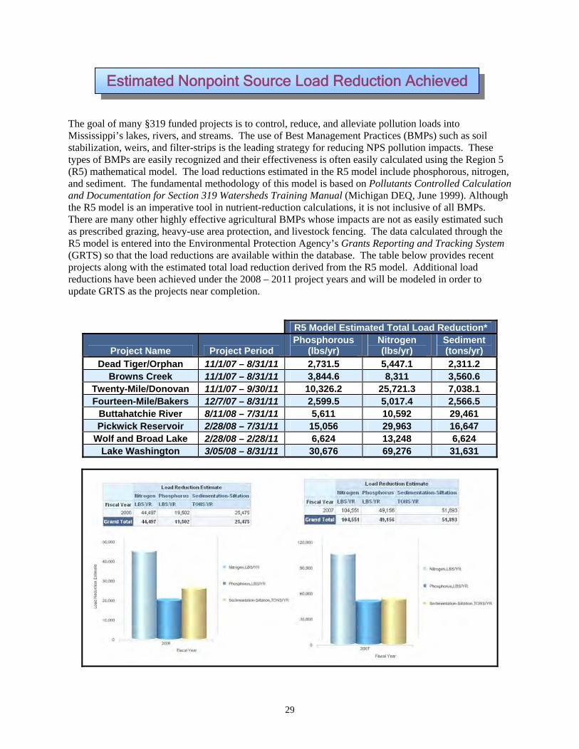
The goal of many §319 funded projects is to control, reduce, and alleviate pollution loads into Mississippi’s lakes, rivers, and streams. The use of Best Management Practices (BMPs) such as soil stabilization, weirs, and filter-strips is the leading strategy for reducing NPS pollution impacts. These types of BMPs are easily recognized and (R5) mathematical model. and sediment. The fundamental and Documentation for Section 319 Watthe R5 model is an imperative tool iThere are many other highly effective aas prescribed grazing, heavy-R5 model is entered into the E(GRTS) so that the load reductions are available wprojects along with the estimreductions have been achieved undeupdate GRTS as the projects near co
Estimated Nonpoint Source Load Reduction Achieved
their effectiveness is often easily calculated using the Region 5 The load reductions estimated in the R5 model include phosphorous, nitrogen,
methodology of this model is based on Pollutants Controlled Calculation ersheds Training Manual (Michigan DEQ, June 1999). Although
n nutrient-reduction calculations, it is not inclusive of all BMPs. gricultural BMPs whose impacts are not as easily estimated such
use area protection, and livestock fencing. The data calculated through the nvironmental Protection Agency’s Grants Reporting and Tracking System
ithin the database. The table below provides recent ated total load reduction derived from the R5 model. Additional load
r the 2008 – 2011 project years and will be modeled in order to mpletion.
R5 Model Estimated Total Load Reduction*
Project Period Phosphorous
(lbs/yr) Nitrogen (lbs/yr)
Sediment (tons/yr) Project Name
Dead Tiger/Orphan 11/1/07 – 8/31/11 2,731.5 5,447.1 2,311.2 Browns Creek 11/1/07 – 8/31/11 3,844.6 8,311 3,560.6
Twenty-Mile/Donovan 11/1/07 – 9/30/11 10,326.2 25,721.3 7,038.1 Fourteen-Mile/Bakers 2,599.5 5,017.4 2,566.5 12/7/07 – 8/31/11
Buttahatchie River 8/11/08 – 7/31/11 5,611 10,592 29,461 Pickwick Reservoir 15,056 29,963 16,647 2/28/08 – 7/31/11
Wolf and Broad Lake 2/28/08 – 2/28/11 6,624 13,248 6,624 Lake Washington 3/05/08 – 8/31/11 30,676 69,276 31,631

Adopt-A-Stream
Adopt-A-Stream (AAS) is a program that promotes environmental stewardship by training citizens about stream ecology, aquatic life, and water chemistry. Volunteers attend water-education workshops or training sessions to learn how to monitor a stream, conduct a stream-cleanup event, or mark storm drains. The Mississippi Wildlife Federation partners with MDEQ in the presentation of these educational sessions. Topics covered include effects of point- and nonpoint-source pollution on water quality, watershed mapping and delineation, water chemistry, and the use of macroinvertebrate surveys as biological indicators of water quality. Field work at a stream is also part of the training events. In 2011, sixteen people attended the traditional two-day AAS workshop and 85 people attended six one-day workshops. In addition, more than 14,500 individuals were exposed to the Adopt-A-Stream Program environmental-education concepts at events around the State that included: seven Envirothon training workshops for 187 high-school students; presentations at six teacher workshops; two stream clean-ups
and a “storm-drain marking” project in the Ross Barnett Reservoir area, Jackson. Also, audience-specific, water-quality training sessions, school-group training, scout-troop trainings, workshops, watershed projects, and large-venue events were conducted. Complimentary water-quality test kits were distributed to interested individuals at many of these events. The distribution of these simple, inexpensive, but accurate test kits will allow more widespread monitoring activities and increase public awareness about stream stewardship.
Envirothon Competition
Envirothon is a competitive learning event for high-school students. The competition tests the student's knowledge of environmental resources including soils, forestry, wildlife, and a special environmental topic each year. During 2011, there were 391 high-school students (53 teams), and 80 team advisors from all regions of Mississippi who were active in the Mississippi Envirothon competitions (regional and state levels). Twenty-one teams participated in the State competition where the winning teams received scholarships and the number one team (Oxford High School) went on to compete in the summer 2011 North American Canon Envirothon competition in New Brunswick, Canada, where “estuaries” was the “current-issue” topic. MDEQ assists with the Envirothon steering committee, training teams, and the statewide competition. In the Fall of 2011, the Mississippi Envirothon partnered with the Mississippi Environmental Education Alliance, MDEQ, and Central Mississippi Resource Conservation &
NPS Education/Public Outreach
30

Development Council to present a two-day conference/teacher workshop at the Mississippi Natural Science Museum in Jackson, Mississippi, which featured the 2012 Envirothon current-event topic of “Nonpoint Source Pollution and Low Impact Development”.
Watershed Harmony Musical Puppet Theater
MDEQ and Bayou Town Productions completed the Watershed Harmony Musical Puppet Theater in October 2003. Since that time, the performance has reached more than 68,000 students, teachers, and others. During the 2011 tour, 8,623 people enjoyed the show. Pre-test/post-test scores revealed a significant increase in knowledge and awareness of water-pollution problems, solutions, and stewardship. The play focuses on the prevention of polluted runoff by promoting the use of best BMPs and individual stewardship to improve
water quality. The Watershed Harmony Puppet Musical conforms to the 4th- and 5th-grade Mississippi Framework Curriculum and the National Science Standards. The performance is frequently used as a school presentation and as a part of environmental field-day student events. In addition to students, the show is enjoyed and seen by all ages and many groups, including civic clubs, special-event groups, summer reading programs, scout troops, and summer camps. The 30-minute musical play is performed on a multi-level, 12’x12’stage that conveys a water-quality stewardship theme. The following is a quote from a school principal that illustrates its educational impact. “I was a classroom teacher for 12 years and have been an administrator for 13 years. Watershed Harmony is, without a doubt, the best presentation I have witnessed in my 25 years in public/private education! The students were totally
The
engrossed in the performance from start to finish, and actually became actors in one segment, which drew the attention of their classmates…” Watershed Harmony Video
Mississippi Urban Forestry Council “Scenic Communities” Green Infrastructure Initiative
Mississippi Urban Forestry Council focused on the MDEQ/Nonpoint Source Pollution-sponsored project called “Scenic Communities of Mississippi.” The project included an updated resource guide called Scenic Communities of Mississippi: A Comprehensive Resource Guide for Green Infrastructure, Sustainability, and Sound Environmental Practices. The Guide includes names, addresses, and subjects such as web sites, grants, state-revolving loans, environmental programs, agencies, and nonprofit organizations that can assist communities with green ordinances, green infrastructure, sources of funding, water-quality information, and other resources. Once the Resource Guide was updated, distribution, and training sessions for 269 communities were conducted during 2011 at venues such as the Mississippi Municipal League Conference where mayors and aldermen packed the training room. A display was set up and resource guides were distributed at conferences and meetings. One community will be named as
31
32
“Scenic Community of the Year 2011”. In addition, the 2011 Mississippi Urban Forestry Annual Conference featured a renowned expert on landscape ordinances and additional speakers on green laws, tree ordinances, stormwater, retrofitting parking lots and street-scapes with 50 people in attendance at the Natural Science Museum in Jackson, Mississippi. In addition to the Scenic Communities Catalog, the following MDEQ documents are available for green planning: Introduction to Urban Community Forestry; Urban Forestry, Mississippi Urban and Community Forestry Management Manual (191 pages); The Community Forest Booklet; and Preserving Trees in Construction Sites. These are available from the Mississippi Forestry Commission. A great web site for information on Green Law ordinances is http://greenlaws.lsu.edu/greenlawtypes.html
Storm Water Workshops
In 2011, MDEQ supported 12 storm-water training sessions with a total of 1,478 people attending. Workshop topics included nonpoint-source pollution, Best Management Practices (BMPs), land use, “Green Infrastructure” (connecting green hubs by using linear green space such as riparian corridors and utility corridors), low-impact development (processing roof and home-lot runoff on-site), and agriculture
the six counties of the Coast and in Jackson at the orestry Council conducted a two-day ordinances
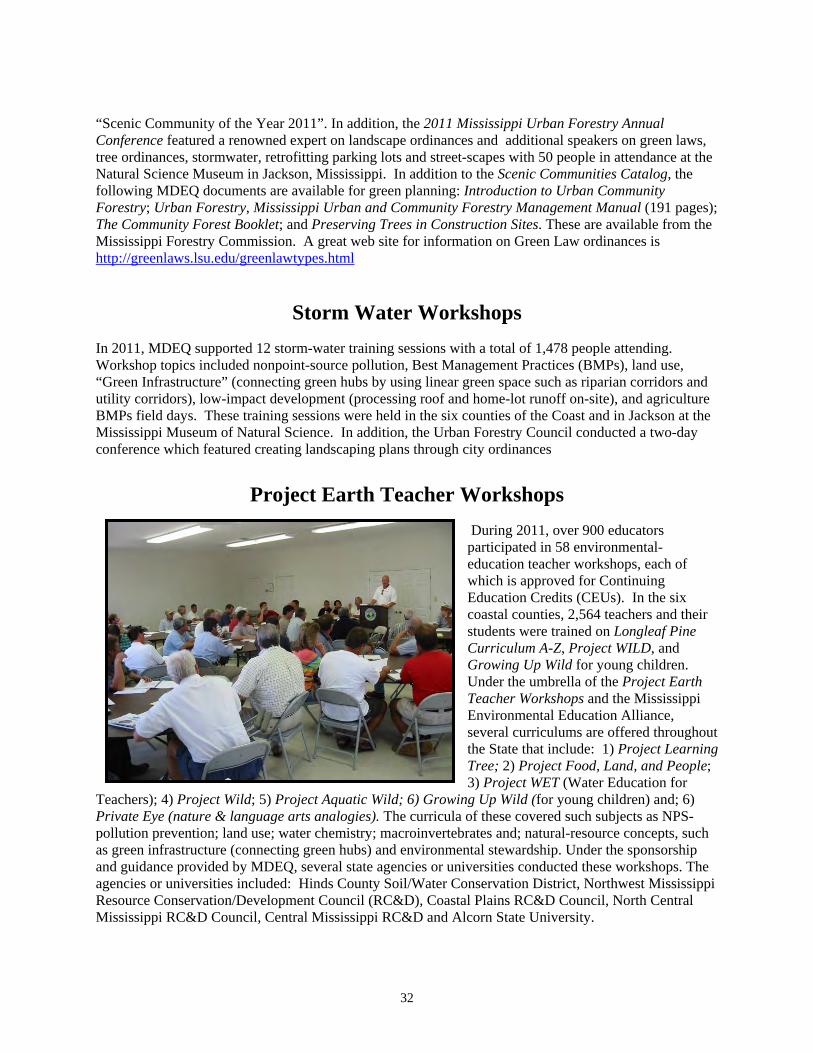
During 2011, over 900 educators participated in 58 environmental-education teacher workshops, each of which is approved for Continuing Education Credits (CEUs). In the six coastal counties, 2,564 teachers and their students were trained on Longleaf Pine Curriculum A-Z, Project WILD, and Growing Up Wild for young children. Under the umbrella of the Project Earth Teacher Workshops and the Mississippi Environmental Education Alliance, several curriculums are offered throughout the State that include: 1) Project Learning Tree; 2) Project Food, Land, and People; 3) Project WET (Water Education for
Teachers); 4) Project Wild; 5) Project Aquatic Wild; 6) Growing Up Wild (for young children) and; 6) Private Eye (nature & language arts analogies). The curricula of these covered such subjects as NPS- pollution prevention; land use; water chemistry; macroinvertebrates and; natural-resource concepts, such as green infrastructure (connecting green hubs) and environmental stewardship. Under the sponsorship and guidance provided by MDEQ, several state agencies or universities conducted these workshops. The agencies or universities included: Hinds County Soil/Water Conservation District, Northwest Mississippi Resource Conservation/Development Council (RC&D), Coastal Plains RC&D Council, North Central Mississippi RC&D Council, Central Mississippi RC&D and Alcorn State University.
BMPs field days. These training sessions were held in Mississippi Museum of Natural Science. In addition, the Urban Fconference which featured creating landscaping plans through city
Project Earth Teacher Workshops
33
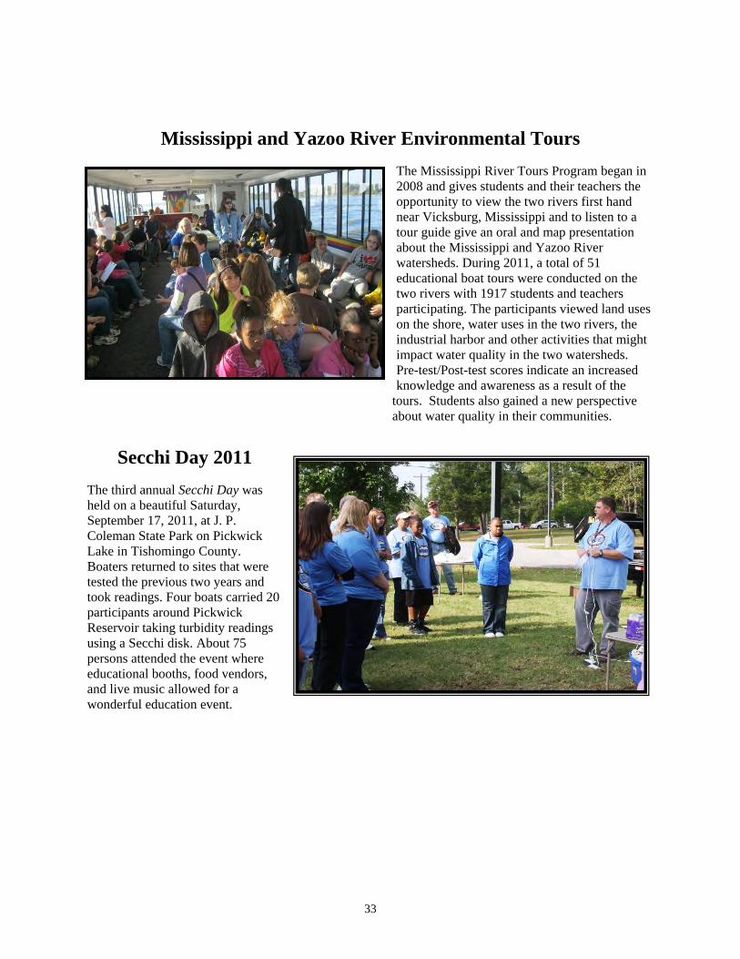
Mississippi and Yazoo River Environmental Tours
The Mississippi River Tours Program began in 2008 and gives students and their teachers the opportunit
tour guabout the Miswatersheds. educational b
participating. on the shore, industrial harimpact watPre-test/Post-knowledge an
about water qualit
Secchi Day 2011
The third annual Secchi Day was held on a beautiful Saturday, September 17, 2011, at J. P. Coleman State Park on Pickwick Lake in Tishomingo County. Boaters returned to sites that were tested the previous two years and took readings. Four boats carried 20 participants around Pickwick Reservoir taking turbidity readings using a Secchi disk. About 75 persons attended the event where educational booths, food vendors, and live music allowed for a wonderful education event.
y to view the two rivers first hand near Vicksburg, Mississippi and to listen to a
ide give an oral and map presentation sissippi and Yazoo River
During 2011, a total of 51 oat tours were conducted on the
two rivers with 1917 students and teachers The participants viewed land uses water uses in the two rivers, the bor and other activities that might
er quality in the two watersheds. test scores indicate an increased d awareness as a result of the
tours. Students also gained a new perspective y in their communities.

34
Environmental Education Camps
During the summer of 2011, a total of 194 students participated in ten each one-week, environmental-camp sessions coordinated by two Mississippi universities and the Natural Science Museum through a partnership with MDEQ. The camp sessions included: 1) The University of Mississippi Wetland and Water Resources Institute conducting five Ecology Day-Camp sessions with over 87 students from grades 2-10; 2) Mississippi State University Wildlife, Fisheries and Aquaculture Department conducting four, one-week Wildlife-Camp sessions with 95 participants and; 3) Mississippi State University Forestry Department conducting one session with 22 students participating.
Battle on the Bayou
The eruption of Civil War-era cannons sent approximately 188 canoes and kayaks down a 9½-mile path toward The Shed
corner, sending a flurry of brightly colored reflections into thtandem riders, were lime green, yellow, orange, brown, blue, red,colorful and eye-catching feature was perhaps the racers' pirate hats, bright ball caps, floppy fisherman hats and psychedelic do-rags. The first racers reached The Shed after about 1 hour and 14 minutes. Gary Simon, a 70-year-old kayaker from Milwaukee, said he and his wife, Sharon, came to Ocean Springs specifically for the race. "We came for two reasons," he said. "One, I'm retired and have been going all over kayaking for 48 years and racing for 12 years. Two, we wanted to support the Gulf Coast after the oil spill incident." Simon said this is his first time on the Mississippi coast, but he has previously raced in Natchez and _____________ Vicksburg.
Barbecue Restaurant. Residents gathered at the Fort Bayou Bridge on Miss. 609 and cheered on participants as they rounded the corner on Old Fort Bayou, coming from the Gulf Hills Hotel & Convention Center starting line. The first racers neared the bridge only 14 minutes into the race, which began at 11 a.m. "Only nine more miles to go," one racer yelled as a cluster of more than 40 boats rounded the
e water. Kayaks, carrying single and white and even pink. The only more
choice of headgear, which included foam
35
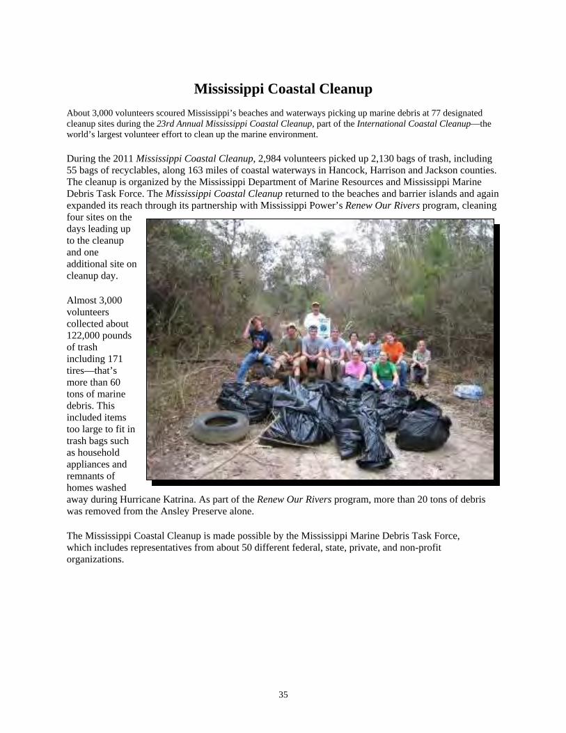
Mississippi Coastal Cleanup
About 3,000 volunteers scoured Mississippi’s beaches and waterways picking up marine debris at 77 designated cleanup sites during the 23rd Annual Mississippi Coastal Cleanup, part of the International Coastal Cleanup—the
nment. world’s largest volunteer effort to clean up the marine enviro
During the 2011 Mississippi Coastal Cleanup, 2,984 volunteers picked up 2,130 bags of trash, including 55 bags of recyclables, along 163 miles of coastal waterways in Hancock, Harrison and Jackson counties. The cleanup is organized by the Mississippi Department of Marine Resources and Mississippi Marine Debris Task Force. The Mississippi Coastal Cleanup returned to the beaches and barrier islands and again expanded its reach through its partnership with Mississippi Power’s Renew Our Rivers program, cleaning four sites on the days leading up to the cleanup and one additional site on cleanup day.
Almost 3,000 volunteers collected about 122,000 pounds of trash including 171 tires—that’s more than 60 tons of marine debris. This included items too large to fit in trash bags such as household appliances and remnants of homes washed away during Hurricane Katrina. As part of the Renew Our Rivers program, more than 20 tons of debris was removed from the Ansley Preserve alone.
The Mississippi Coastal Cleanup is made possible by the Mississippi Marine Debris Task Force, which includes representatives from about 50 different federal, state, private, and non-profit organizations.
36
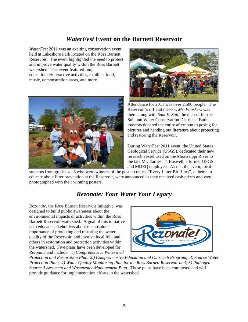
WaterFest Event on the Barnett Reservoir
WaterFest 2011 was an exciting conservation event held at Lakeshore Park located on the Ross Barnett Reservoir. The event highlighted the and improve water quality within the Ross Barnett watershed. The event featured fun, educational/interactive activities, exhibits, food, music, demonstration areas, and more.
ople. The s was for the
Soil and Water Conservation Districts. Both mascots donated the entire afternoon to posing for pictures and handing out literature about protecting and restoring the Reservoir.
need to protect
Attendance for 2011 was over 2,500 peReservoir’s official mascot, Mr. Whiskerthere along with Sam E. Soil, the mascot
During WaterFest 2011 event, the United States Geological Service (USGS), dedicated their new research vessel used on the Mississippi River to the late Mr. Earnest T. Boswell, a former USGS and MDEQ employee. Also at the event, local
students from grades 4 - 6 who were winners of the poster contest “Every Litter Bit Hurts”, a theme to educate about litter prevention at the Reservoir, were announced as they received cash prizes and were photographed with their winning posters.
Rezonate: Your Water Your Legacy
Rezonate, the Ross Barnett Reservoir Initiative, was designed to build public awareness about the environmental impacts of activities within the Ross Barnett Reservoir watershed. A goal of this initiative is to educate stakeholders about the absolute importance of protecting and restoring the water quality of the Reservoir, and involve local folk and others in restoration and protection activities within the watershed. Five plans have been developed for Rezonate and include: 1) Comprehensive Watershed Protection and Restoration Plan; 2.) Comprehensive Education and Outreach Program;, 3) Source Water Protection Plan; 4) Water Quality Monitoring Plan for the Ross Barnett Reservoir and; 5) Pathogen Source Assessment and Wastewater Management Plan. These plans have been completed and will provide guidance for implementation efforts in the watershed.

37
Mississippi Environmental Education Alliance (MEEA)
MDEQ’s Nonpoint Source Pollution Management Branch assisted MEEA with its annual 2011 conference training. The MEEA and International Envirothon Competition special topic was “Nonpoint Source Pollution and Low Impact Development.” Nearly 50 teachers and environmental educators attended the MEEA training at this conference.. Tours were made on the groundsduring construction of the watershed mappingconnected green hubs with Clean Water Act; Sampling. Onspeaker.
MDEQ and the Mississippi Natural Scieevent which was held both outside and inside the Museum on September 23, 2011. A total of twelve schools attended from the 3 Pearl River Watershed and 9 Yazoo River Watersheds which included a total of 752 students and 79 teachers.
of the Mississippi Natural Science Museum to view BMPs installed on those grounds museum building and adjacent parking lots. Interactive sessions included
, soil profiles, and a Green Infrastructure mapping exercise where participants linear travel corridors for wildlife. Other sessions included A History of the
Nonpoint Source Pollution and Best Management Practices and; Macroinvertebrate e other session was given entitled Low Impact Development and featured the key-note
Make-A-Splash Event nce Museum partnered to host this water-related educational
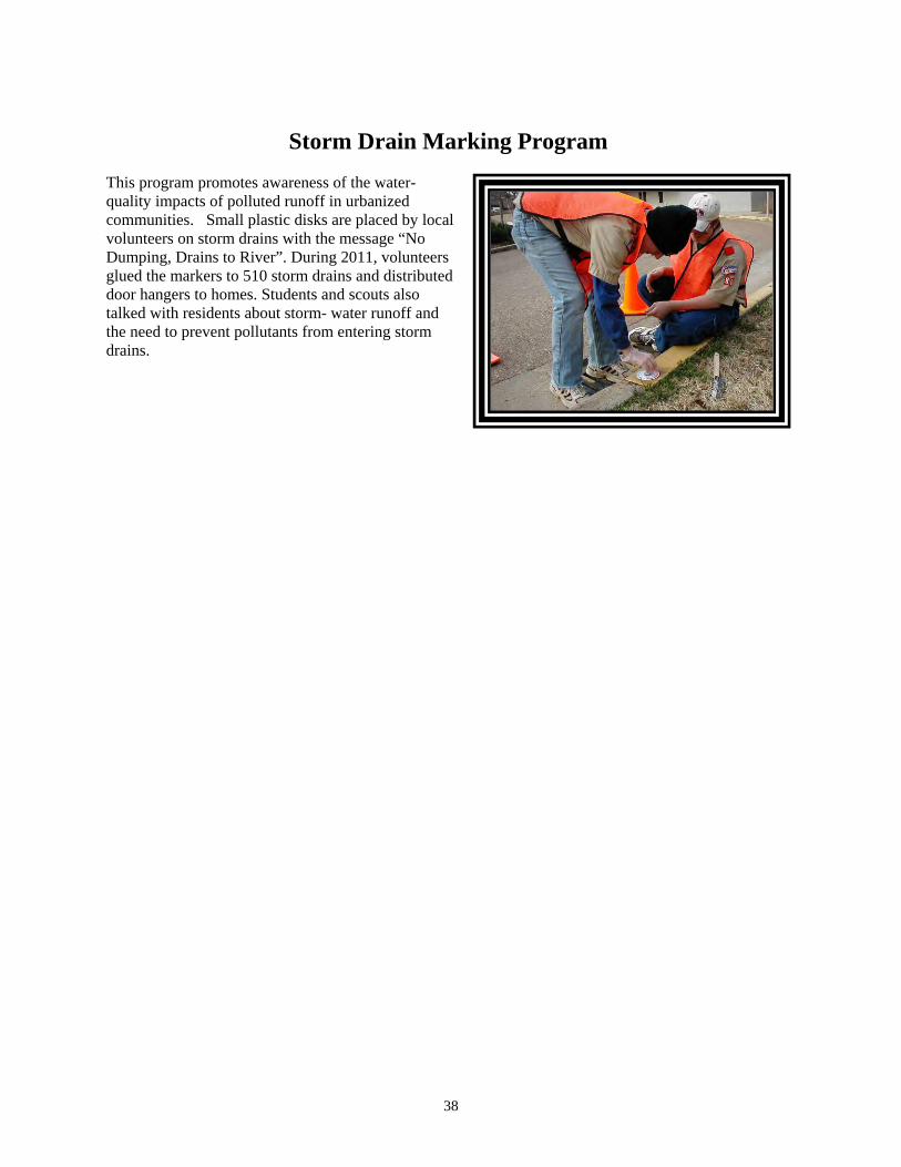
Storm Drain Marking Program This program promotes awareness of the water-quality impacts of polluted runoff in urbanized communities. Small plastic disks are placed by local volunteers on storm drains with the message “No Dumping, Drains to River”. During 2011, volunteers glued the markers to 510 storm drains and distributed door hangers to homes. Students and scouts also talked with residents about storm- water runoff and the need to prevent pollutants from entering storm drains.
38
39
Videos and Manuals:
Ross Barnett ReseRezonate project, MDEQ d
ecosystem, urban developcreated in 2010 to quality improvemehttp://rezonate-ms.org/
The Turkey Creek Video project began in January 2009 and has been widely distributed to stakeholders and community members. The Turkey Creek Watershed is located in Harrison County near the Mississippi Gulf Coast, north of Gulfport. It is predominantly an African-American community. http://deq.state.ms.us/MDEQ.nsf/page/NPS_TurkeyCreek?OpenDocument
Red Creek Video - an entertaining documentary film entitled “The Search for Red Bluff” was produced and widely distributed. This film includes a rich historical narrative of the watershed and describes the potential outcome of poor management of our natural resources and lack of proper BMP implementation. http://deq.state.ms.us/MDEQ.nsf/page/NPS_RedCreekVideo?OpenDocument
Reigning over Runoff video is a production of the Natural Resources Initiative of Mississippi. This short film, in a compelling way, focuses on a few practices that homeowners and communities can use to enhance water quality. Noteworthy are scenes from selected streams, rivers, wildflowers, and more, the reader can view this film by going to the following web-site: http://www.reigningoverrunoff.org/
rvoir Initiative, Rezonate - As part of the eveloped an Education and development
video that contains footage depicting Ross Barnett Reservoir’s ment, parks, and recreation. The video was
help aid in the preservation, protection, and water-nt throughout the Ross Barnett Reservoir area.

NPS - Related Programs
Planning & management at construction sites,developments often requireto help inenvironmtask, MDEQ collaboratively Design Manual for the CoThe first edition of thhas served as a guidance docusediment-management issexpanding the promcountry. As a result, mthe requirements for adequate storm-water planning and a greater range of construction and develop activities must be managed under the regulatory authority of MDEQ. There have been substantial advances in the state-of-the-art in runoff management and environmental protection related to erosion mitigation and storm-water pollution. As a result, MDEQ recently elected to initiate a process of review and improvement of the current Manual, with significant input from MDOT and USDA. The updated manual has been completed and can be seen on MDEQ’s web site as:
http://deq.state.ms.us/MDEQ.nsf/page/NPS_Publications_Literature?OpenDocument
Design Manual for the Control of Erosion -Stormwater in urban areas, and commercial
s innovative application of art and science sure people are held safe, property is protected, and the ent is not adversely affected. To help with this management
developed a document titled Planning & ntrol of Erosion, Sediment and Stormwater.
e “Manual” was implemented in April 1994, and ment for mitigating storm-water and
ues since that time. However, EPA is ulgation of storm-water regulations throughout the
ore municipalities in the State are falling under
Scenic Communities Resource Guide Catalog – a Comprehensive Resource Guide for Green Infrastructure, Sustainability, Conservation and Sound Environmental Practices. Completed in 2011 by the Mississippi Urban Forestry Council with partial funding from the MDEQ Nonpoint Source Pollution Program. The Catalog may be used by county and municipal governments to locate grants, state revolving loans, NPS experts, and materials to improve the quality of life in their communities. www.msurbanforest.com
Protecting Our Waters…Reducing Nutrients in Mississippi - This is a video that was developed to tell Mississippi’s nutrient reduction story. It premiered at the first Mississippi Nutrient/Hypoxia Summit held on October 1, 2010. http://deq.state.ms.us/MDEQ.nsf/page/NPS_Nutrientreductinms?OpenDocument
Bee Lake Watershed Success Story- Available for public on MDEQ Website http://deq.state.ms.us/MDEQ.nsf/page/NPS_BeeLake_Video?OpenDocument
40

41
Agricultural NPS Advances in Mississippi The Farm Security and RuInvestment Act of 2008 is llegislation for conservation fundiand for focusing on enviroissues. The conservation provisions assist farmers and ranchers in menvironmental challenges on their land. This legislation simexisting programs and creatprograms to address high priority environmental and production goals. The 2008 Farm Bill enhances the long-term quality of our environment and conservation of our natural resources. Under The Farm Bill, a number of programs were introduced and implemented in Mississippi. Under one such program, the Environmental Quality Incentives Progenrolled for a total funding of $26,739,935.. The Wildlife Habitat In$1,543,238 for the enlistment of 14,360 acres.
The NRCS is partnering with Mississippi and other states to improve water quality within watersheds of the Mississippi River Basin. Through the partnership, the NRCS has created the Mississippi River Basin Healthy Watershed Initiative (MRBI). This initiative will implement voluntary conservation practices by landowners, state agencies, and federal agencies that will concentrate practices by containing nutrients rather than controlling them. This initiative will also significantl prove water quality within the Mississippi River Basin.
ral andmark
ng nmental
eeting
plifies es new
ram (EQIP), 134,840 acres were centive Program (WHIP) awarded
Healthy Watershed initiative
y decrease all runoff and im

42
The Mississippi 319 Waste-Pesticide Disposal Program Mississippi farmers continue to take advantage of economical ways to address waste-pesticide disposal
y in their watersheds at the same time. Through a 319 grant from cide disposal-collection events were planned and held in federal fiscal
re coordinated by the MSU Extension Service, with assistance from the of the Mississippi Department of Agriculture and Commerce. Since
sposal events were held in Brooksville, Cleveland, and Houston. waste-pesticide products were brought to the collection sites by farmers from
collected and properly disposed of by a licensed, hazardous-waste more than $67,700 in disposal fees that would have incurred in the
eflect a positive collaboration of farmers, farm-support groups, onmental agencies.
These programs and prior ones funded by 319 grants have had a positive impact on reducing environmental risks and improving water quality in rural Mississippi while providing farmers an economical way to dispose of waste-pesticide products.
ental risks associated with these waste products, the events collectivelydisposal events will be held in earl
med to further reduce environmental, water-of the State.
Water-Pollution Control Revolving-Loan Fund
rol Revolving Loan Fund program provides low-interest loans to public entities ment of wastewater, storm-water, and nonpoint source
Funding for these projects comes from federal capitalization grants from EPA, state match, loan repayments, and interest earnings on deposits. During 2011, MDEQ funded 19 new projects for a total of $24,265,643 from the Water Pollution Control Revolving Loan Fund program.
problems and improve water qualitMDEQ, three additional waste-pestiyear 2011. These events weBureau of Plant Industry, a division MDEQ’s annual report in 2010, three diAlmost 56,000 pounds of 15 counties where the products were contractor. The event saved farmers absence of the program. These results reducational institutions, and envir
Since the inception of the program, about 1.26 million pounds of waste-pesticides have been collected from more than 590 farmers in just about all of Mississippi. In addition to reducing potential
saved farmers about y 2012 and hopefully in future
quality, and health-related
environm$1,304,700 in disposal costs. Additional years. These events will be welcorisks in agricultural areas
The Water Pollution Contin the State for the construction, repair, or replacepollution-control projects.

43
Through this program, non-point source needs for the State were estimated in the 2008 Clean Water Needs Survey. MDEQ contracted with FTN Associates towith a Total Maximum Daily Load (TM303(d) report as impaired, y the pollutant causing the impairment, identifGIS analysis of the watershed to estimate the numfigures to calculate total costs. Sanitary survereviewed to estimate needs and repair c s. The resulting needs and repair costs we
Croplands Livestock Silviculture Stream-bank Restoration Onsite Wastewater
The Gulf Region Water and Wastewater Plan The Gulf Region Water and Wastewater Plan (GRWWP) was approved by HUD in early 2007. The five County Utility Authorities (CUAs), as well as the municipalities in Jackson County, received their initial grant awards during the spring and summer months. Environmental review and preliminary-design work began in earnest on most of the 65 projects identified in the Plan. Two projects, a new well and tank in Poplarville (owned by the Pearl River CUA), and a new Reverse Osmosis water-treatment plant in Moss Point began construction in late 2007. Construction and land acqui complete at this time, with several others neariby the grantfour cities in Jackson Countycomplete with all original GRWWP projects.
The Federal Safe Drinking Water Actthe states to develop Source Water As as to compel states to devise and m potential contaminant sources. The system intakes used in the Management Approach that was designeThis strategy has been completed and integration efforts are underway with the Basin Management Teams. Mississippi has accepted EPA Region IV’s offer to assist with these projects. Tennessee Valley Authority (TVA) offered assistance and is now participating in these projects as well. Meetings with the three public surface-water systems operating in the State have been completed; additional meetings are anticipated. At the present time, SWAPs have been completed for community
estimate BMP needs and costs for water bodies DL). FTN also did this for water bodies listed on the Section
but where a TMDL had not yet been written. The strategy used was to identify or determine the recommended load reduction, conduct a
ber and type of BMPs needed, and use NRCS cost ys from the Mississippi Department of Health were also
osts for areas with high rates of failing, onsite-treatment systemre:
$ 72,000,000 $ 251,000,000 $ 16,000,000 $ 1,420,000,000 $ 154,000,000
sition continue throughout all five counties. Thirty projects are substantiallyng completion. Over $480 million has been spent to date
recipients. Land acquisition has continued to be the largest remaining hurdle. Three of the have closed their grants, and Jackson and Pearl River CUAs are nearly
Source Water Assessment Program
(SDWA), reauthorized by Congress in 1996 added provisions for sessment Programs (SWAPs). The clear intent of Congress w
adopt measures to enhance the protection of all public-water systems froSource Water Protection Strategy for the four public surface-water-
State involves integrating drinking-water protection into Mississippi’s Basin d to protect and restore the quality of the State’s water resources.

44
water systems in all 82 counties. MDEQ has provided the public water-supply operators in the State with their SWAP reports. Since July 1st, 2,005 preliminary-assessment reports have been required for all new water-well permits. This pre-SWAP report is used to critique proposed well sites to avoid the drilling of new wells into known plumes of contamination or drilling too close to identified Potential Contaminant Sources (PCSs). The TVA has completed SWAPs for three surface-water source systems in the State. A data tracking system has been designed to comply with EPA’s Source Water Program Activities Measures. This GIS application allows MDEQ to track which systems have implemented source-water protection strategies.
Storm Water Program The Environmental Permits Division of MDEQ, as of November 30, 2011, has issued the following coverages (authorizations) under several different storm-water general permits: 149 construction projects
addition, the Large d approximately 484
of five acres and greater, 55 regulated industrial facilities, and 83 mining sites. InConstruction Storm-Water General Permit was reissued on January 11, 2011 anconstruction projects have been recovered under this reissued general permit.

45
CCoonnttaacctt IInnffoorrmmaattiioonn
Zoffee Dahmash, P.E. NPS Program Coordinator 601-961-5137 [email protected] Hollis Allen Grant/Project Coordinator 601-961-5549 [email protected] Daniel Stuart Project Engineer 601-961-5576 [email protected] Steven Utroska Project Engineer 601-961- 5102 [email protected] Laura Beiser Education/ Public Outreach Coordinator 601-961-5373 [email protected] Kay Whittington, P.E. Basin Management Program Coordinator 601-961-5078 [email protected]