mission long-term programme - pwri · ma ng em t(ichar) advisor tra ing & research advisor...
TRANSCRIPT
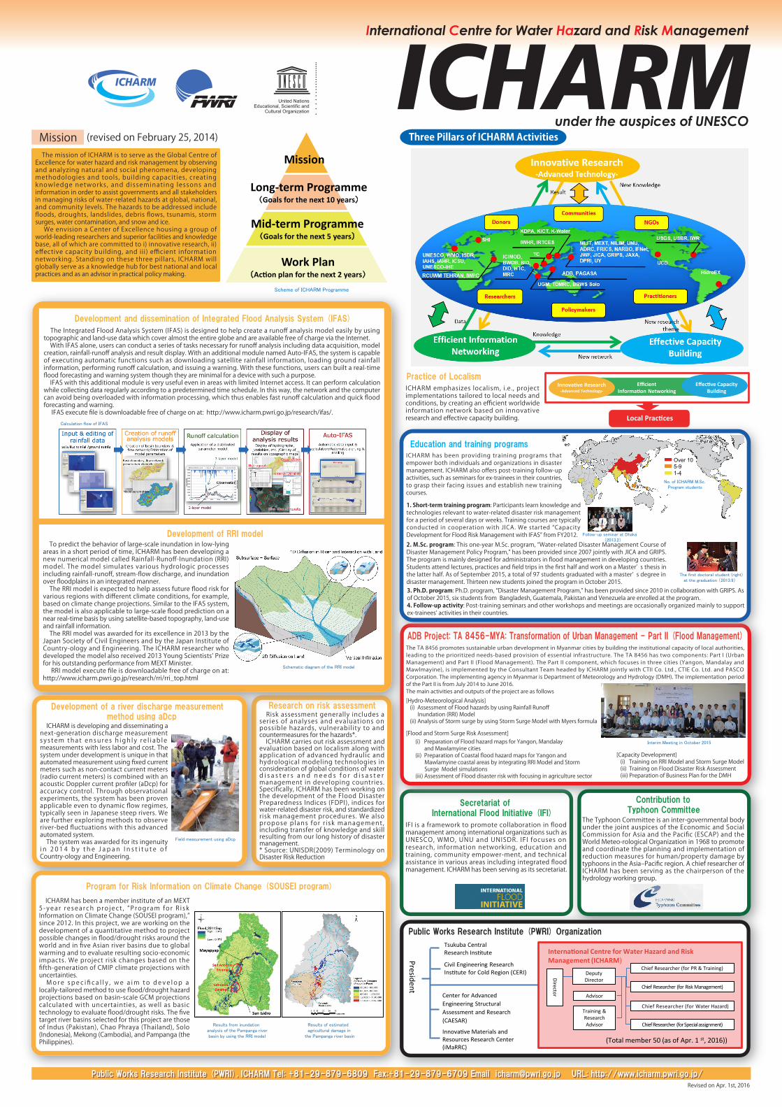
Three Pillars of ICHARM Activities
ICHARM Programmeの構成
Mission (revised on February 25, 2014)
Efficient Information Networking
Innovative Research-Advanced Technology-
Effective Capacity Building
Local Practices
( )
Results from inundation analysis of the Pampanga river basin by using the RRI model
Field measurement using aDcp
Schematic diagram of the RRI model
No. of ICHARM M.Sc. Program students
Follow-up seminar at Dhaka (2013.2)
The first doctoral student (right) at the graduation (2013.9)
Interim Meeting in October 2015
Development and dissemination of Integrated Flood Analysis System (IFAS)
Calculation flow of IFAS
Education and training programs
ADB Project: TA 8456-MYA: Transformation of Urban Management - Part II (Flood Management)
Practice of Localism
Secretariat of International Flood Initiative (IFI)
Research on risk assessmentDevelopment of a river discharge measurement method using aDcp
Development of RRI model
Scheme of ICHARM Programme
Mission
Long-term Programme(Goals for the next 10 years)
Mid-term Programme(Goals for the next 5 years)
Work Plan(Action plan for the next 2 years)
Program for Risk Information on Climate Change (SOUSEI program)
Public Works Research Institute (PWRI), ICHARM Tel: +81-29-879-6809 Fax:+81-29-879-6709 Email [email protected] URL: http://www.icharm.pwri.go.jp/Public Works Research Institute (PWRI), ICHARM Tel: +81-29-879-6809 Fax:+81-29-879-6709 Email [email protected] URL: http://www.icharm.pwri.go.jp/
Results of estimated agricultural damage in the Pampanga river basin
ICHARM emphasizes localism, i.e., project implementations tailored to local needs and conditions, by creating an efficient worldwide information network based on innovative research and effective capacity building.
The mission of ICHARM is to serve as the Global Centre of Excellence for water hazard and risk management by observing and analyzing natural and social phenomena, developing methodologies and tools, building capacities, creating knowledge networks , and disseminat ing lessons and information in order to assist governments and all stakeholders in managing risks of water-related hazards at global, national, and community levels. The hazards to be addressed include floods, droughts, landslides, debris flows, tsunamis, storm surges, water contamination, and snow and ice. We envision a Center of Excellence housing a group of world-leading researchers and superior facilities and knowledge base, all of which are committed to i) innovative research, ii) effective capacity building, and iii) efficient information networking. Standing on these three pillars, ICHARM will globally serve as a knowledge hub for best national and local practices and as an advisor in practical policy making.
ICHARM has been providing training programs that empower both individuals and organizations in disaster management. ICHARM also offers post-training follow-up activities, such as seminars for ex-trainees in their countries, to grasp their facing issues and establish new training courses.
1. Short-term training program: Participants learn knowledge and technologies relevant to water-related disaster risk management for a period of several days or weeks. Training courses are typically conducted in cooperation with JICA. We started “Capacity Development for Flood Risk Management with IFAS” from FY2012.
2. M.Sc. program: This one-year M.Sc. program, “Water-related Disaster Management Course of Disaster Management Policy Program,” has been provided since 2007 jointly with JICA and GRIPS. The program is mainly designed for administrators in flood management in developing countries. Students attend lectures, practices and field trips in the first half and work on a Master’ s thesis in the latter half. As of September 2015, a total of 97 students graduated with a master’ s degree in disaster management. Thirteen new students joined the program in October 2015.3. Ph.D. program: Ph.D. program, “Disaster Management Program,” has been provided since 2010 in collaboration with GRIPS. As of October 2015, six students from Bangladesh, Guatemala, Pakistan and Venezuela are enrolled at the program.4. Follow-up activity: Post-training seminars and other workshops and meetings are occasionally organized mainly to support ex-trainees’ activities in their countries.
Over 105-91-4
The TA 8456 promotes sustainable urban development in Myanmar cities by building the institutional capacity of local authorities, leading to the prioritized needs-based provision of essential infrastructure. The TA 8456 has two components: Part I (Urban Management) and Part II (Flood Management). The Part II component, which focuses in three cities (Yangon, Mandalay and Mawlmayine), is implemented by the Consultant Team headed by ICHARM jointly with CTII Co. Ltd., CTIE Co. Ltd. and PASCO Corporation. The implementing agency in Myanmar is Department of Meteorology and Hydrology (DMH). The implementation period of the Part II is from July 2014 to June 2016.The main activities and outputs of the project are as follows
IFI is a framework to promote collaboration in flood management among international organizations such as UNESCO, WMO, UNU and UNISDR. IFI focuses on research, information networking, education and training, community empower-ment, and technical assistance in various areas including integrated flood management. ICHARM has been serving as its secretariat.
Contribution to Typhoon Committee
The Typhoon Committee is an inter-governmental body under the joint auspices of the Economic and Social Commission for Asia and the Pacific (ESCAP) and the World Meteo-rological Organization in 1968 to promote and coordinate the planning and implementation of reduction measures for human/property damage by typhoons in the Asia‒Pacific region. A chief researcher of ICHARM has been serving as the chairperson of the hydrology working group.
Risk assessment generally includes a series of analyses and evaluations on possible hazards, vulnerabil ity to and countermeasures for the hazards*. ICHARM carries out risk assessment and evaluation based on localism along with application of advanced hydraulic and hydrological modeling technologies in consideration of global conditions of water d i s a s t e r s a n d n e e d s f o r d i s a s t e r management in developing countries. Specifically, ICHARM has been working on the development of the Flood Disaster Preparedness Indices (FDPI), indices for water-related disaster risk, and standardized risk management procedures. We also propose plans for r i sk management , including transfer of knowledge and skill resulting from our long history of disaster management.* Source: UNISDR(2009) Terminology on Disaster Risk Reduction
The Integrated Flood Analysis System (IFAS) is designed to help create a runoff analysis model easily by using topographic and land-use data which cover almost the entire globe and are available free of charge via the Internet. With IFAS alone, users can conduct a series of tasks necessary for runoff analysis including data acquisition, model creation, rainfall-runoff analysis and result display. With an additional module named Auto-IFAS, the system is capable of executing automatic functions such as downloading satellite rainfall information, loading ground rainfall information, performing runoff calculation, and issuing a warning. With these functions, users can built a real-time flood forecasting and warning system though they are minimal for a device with such a purpose. IFAS with this additional module is very useful even in areas with limited Internet access. It can perform calculation while collecting data regularly according to a predetermined time schedule. In this way, the network and the computer can avoid being overloaded with information processing, which thus enables fast runoff calculation and quick flood forecasting and warning. IFAS execute file is downloadable free of charge on at: http://www.icharm.pwri.go.jp/research/ifas/.
To predict the behavior of large-scale inundation in low-lying areas in a short period of time, ICHARM has been developing a new numerical model called Rainfall-Runoff-Inundation (RRI) model. The model simulates various hydrologic processes including rainfall-runoff, stream-flow discharge, and inundation over floodplains in an integrated manner. The RRI model is expected to help assess future flood risk for various regions with different climate conditions, for example, based on climate change projections. Similar to the IFAS system, the model is also applicable to large-scale flood prediction on a near real-time basis by using satellite-based topography, land-use and rainfall information. The RRI model was awarded for its excellence in 2013 by the Japan Society of Civil Engineers and by the Japan Institute of Country-ology and Engineering. The ICHARM researcher who developed the model also received 2013 Young Scientists’ Prize for his outstanding performance from MEXT Minister. RRI model execute file is downloadable free of charge on at: http://www.icharm.pwri.go.jp/research/rri/rri_top.html
ICHARM is developing and disseminating a next-generation discharge measurement s y s tem tha t ensu re s h igh l y r e l i ab le measurements with less labor and cost. The system under development is unique in that automated measurement using fixed current meters such as non-contact current meters (radio current meters) is combined with an acoustic Doppler current profiler (aDcp) for accuracy control. Through observational experiments, the system has been proven applicable even to dynamic flow regimes, typically seen in Japanese steep rivers. We are further exploring methods to observe river-bed fluctuations with this advanced automated system. The system was awarded for its ingenuity i n 2 0 1 4 b y t h e J a p a n I n s t i t u t e o f Country-ology and Engineering.
ICHARM has been a member institute of an MEXT 5 -yea r re sea rch p ro jec t , “P rogram fo r R i sk Information on Climate Change (SOUSEI program),” since 2012. In this project, we are working on the development of a quantitative method to project possible changes in flood/drought risks around the world and in five Asian river basins due to global warming and to evaluate resulting socio-economic impacts. We project risk changes based on the fifth-generation of CMIP climate projections with uncertainties. Mo re s pe c i fi c a l l y , we a im t o d e ve l op a locally-tailored method to use flood/drought hazard projections based on basin-scale GCM projections calculated with uncertainties, as well as basic technology to evaluate flood/drought risks. The five target river basins selected for this project are those of Indus (Pakistan), Chao Phraya (Thailand), Solo (Indonesia), Mekong (Cambodia), and Pampanga (the Philippines).
[Hydro-Meteorological Analysis] (i) Assessment of Flood hazards by using Rainfall Runoff Inundation (RRI) Model (ii) Analysis of Storm surge by using Storm Surge Model with Myers formula
Public Works Research Institute (PWRI) Organization
President
Tsukuba Central Research Institute
Civil Engineering Research Institute for Cold Region (CERI)
International Centre for Water Hazard and Risk Management (ICHARM)
International Centre for Water Hazard and Risk Management (ICHARM)
Advisor
Training & Research Advisor
Chief Researcher (for Water Hazard)
Chief Researcher (for Risk Management)
Chief Researcher (for PR & Training)
Chief Researcher (for Special assignment)
(Total member 50 (as of Apr. 1 st, 2016))
Director
Deputy Director
Center for Advanced Engineering Structural Assessment and Research (CAESAR)
Innovative Materials and Resources Research Center(iMaRRC)
Revised on Apr. 1st, 2016
[Flood and Storm Surge Risk Assessment]
[Capacity Development] (i) Training on RRI Model and Storm Surge Model (ii) Training on Flood Disaster Risk Assessment (iii) Preparation of Business Plan for the DMH
(i) Preparation of Flood hazard maps for Yangon, Mandalay and Mawlamyine cities (ii) Preparation of Coastal flood hazard maps for Yangon and Mawlamyine coastal areas by integrating RRI Model and Storm Surge Model simulations (iii) Assessment of Flood disaster risk with focusing in agriculture sector