minutes of the 36th meeting of the expert appraisal...
TRANSCRIPT

1
Minutes of the 36th meeting of the Expert Appraisal Committee (EAC) held on 31st August, 2018 for appraisal of coal mining projects at Indira Paryavaran Bhawan, Ministry of Environment, Forest and Climate Change, New Delhi-3 A. The 36th meeting of the Expert Appraisal Committee (EAC) for Thermal & Coal mining projects was held on 31st August, 2018 in the Ministry to consider the proposals relating to coal mining sector. List of EAC members and the project proponent/participants is at Annexure-I & II, respectively. B. Confirmation of minutes There being no comments from any of the members of the Committee, minutes of the 34th meeting of the EAC held on 24th July, 2018 were confirmed. C. Details of the proposals considered during the meeting, deliberations made and the recommendations of the Committee, are explained in the respective agenda items as under:- Agenda No.36.1 Expansion of Khairaha Underground Mine Project form (0.585 MTPA to 0.819 MTPA) in ML area 472.065 ha of M/s South Eastern Coalfields Limited located in Burhar Tehsil, District Shahdol (Madhya Pradesh) - For EC 36.1.1 The proposal is for environment clearance for expansion of Khairaha Underground Mine Project form 0.585 MTPA to 0.819 MTPA in mine lease area 472.065 ha of M/s South Eastern Coalfields Limited located in District Shahdol (Madhya Pradesh). 36.1.2 Facts of the proposal, as ascertained from the proposal documents and as revealed from the discussions held during the meeting, are given as under: (i) The project is located in Burhar Tehsil, Shahdol District at geographic coordinates of 23008’08’’ to 23010’23’’ N and 81026’48’’ to 81028’16’’ East. Soft copy of the KML file, indicating the project location, has been submitted by the PP. (ii) The project had been granted environment clearance by the MoEF&CC vide letter dated 28th July, 2005 based on the public hearing conducted on 30th October, 2003 at PWD Rest House, Shahdol (MP). (iii) No joint venture cartel has been formed to operate the mine. Khairaha Underground Mine Project has been proposed to be operated solely by the M/s ECL. (iv) No coal linkages have been entrusted for mine lease in Khairaha Underground Mine Project. (v) Project does not fall in the Critically Polluted Area (CPA), where the MoEF&CC’s vide its OM dated 13th January, 2010 has imposed moratorium on grant of environment clearance. (vi) Approximately, 529 employments are likely to be generated from the project. However, nature of employment viz. temporary or permanent has not been mentioned by the PP. (vii) Likely benefits to be generated from the project include development of infrastructure and market, generation of employment thereby ensuring socio-economic growth at local and national level. (viii) The proposal envisages expansion of production capacity by 40% from 0.585 MTPA to 0.819 MTPA.

2
(ix) The Regional Office, Bhopal conducted site inspection of the area on 9th May, 2018 to assess the status of compliance of conditions, stipulated in the environment clearance dated 28th July, 2005. Report is yet to be submitted by the Regional Office. (x) Total area of the coal block is 652.874 ha. However, as per approved Mining Plan, the area has been reported to be 472.065 ha. The Mining Plan, including Mine Closure Plan, has been reported to be approved by the SECL Board on 27th November, 2017. However, detail pertaining to the proposed use, if any, of balance area of 180.809 ha (652.874-472.065 ha) has not been provided by the PP. (xi) The PP, vide application dated 28th December, 2017, has applied for obtaining the approval of Central Groundwater Board for withdrawal of ground water. Updated status of the approval has not been submitted by the PP. (xii) Baisaha and Sarpha nalla are located on eastern and western side at a distance of more than 100 meters from the mine lease boundary. In addition to this, 2 seasonal ponds also exist within the project area. However, further detail if the seasonal ponds have been proposed to be kept intact or arrangement for alternate water sources for the persons, if any, dependent on them, has not been provided by the PP. (xiii) Total geological reserve reported in the mine lease area is 44.235 MT with 35.189 MT mineable reserve and 14.745 extractable reserve. As per detail furnished by the PP, 13.385 MT of reserve have been estimated (as on 1st April, 2018) as extractable reserve with extraction percent of 42. (xiv) Grade of coal has been reported as G6 & G7. The category of gassiness of seam is classified as Degree-I. Average gradient of the seam has been reported to be 1in 23. Seam thickness varies between 1.20 m – 4.72 m. The PP has proposed working in two seams viz. seam VII (Top/combined), Seam-VI(B) as per detail given below:
S. No. Seam No. Minimum thickness (m) Maximum thickness (m)
1 Seam-VII(Top) 1.20 2.28
2 Seam-VII(Comb.) 2.25 4.72
3 Seam VI B 1.20 4.67
(xv) Availability of ground water has been reported to be varying between 60 m – 70 m. Total water requirement has been estimated at 1,000 KL, comprising of 900 industrial purposes and 100 KL for domestic purposes. Estimation of total water requirement includes filter water supply for Continuous Miner. (xvi) Mining method envisages mechanized board and pillar method with Side Discharge Loader (SDL) and Continuous Miner. (xvii) Life of mine has been estimated as 17 years (as on 1st April, 2018). (xviii) Ambient air quality seasonal data has been documented for the period of May-June, 2002 and ambient air quality parameters viz. SPM, RPM, SO2 and NOX were analyzed and reported to be within the prescribed limits. (xix) Transportation of coal has been proposed through belt conveyor in pit head, by tippers from surface to siding and by rail wagon from siding to consumers. (xx) Project, being a UG mine, does not involve areas for storage of over burden (OB). (xxi) Land use details, pre-mining and post mining, as made available by the PP, is given as under:
Pre-mining
S.N. Landuse Within ML Area (ha)
Outside ML Area (ha)
Total (ha)
1. Agricultural Land 424.785 -- 424.785
2. Forest Land -- -- --
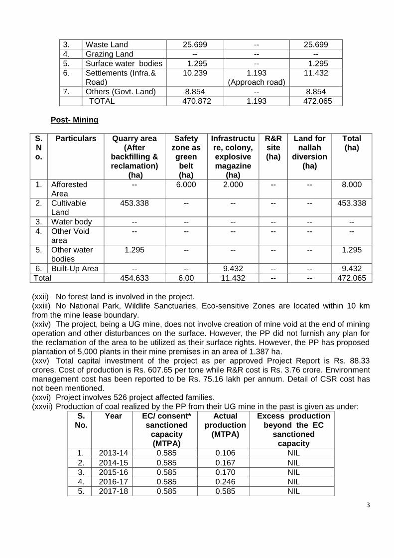
3
3. Waste Land 25.699 -- 25.699
4. Grazing Land -- -- --
5. Surface water bodies 1.295 -- 1.295
6. Settlements (Infra.& Road)
10.239 1.193 (Approach road)
11.432
7. Others (Govt. Land) 8.854 -- 8.854
TOTAL 470.872 1.193 472.065
Post- Mining
S. No.
Particulars Quarry area (After
backfilling & reclamation)
(ha)
Safety zone as green belt (ha)
Infrastructure, colony, explosive magazine
(ha)
R&R site (ha)
Land for nallah
diversion (ha)
Total (ha)
1. Afforested Area
-- 6.000 2.000 -- -- 8.000
2. Cultivable Land
453.338 -- -- -- -- 453.338
3. Water body -- -- -- -- -- --
4. Other Void area
-- -- -- -- -- --
5. Other water bodies
1.295 -- -- -- -- 1.295
6. Built-Up Area -- -- 9.432 -- -- 9.432
Total 454.633 6.00 11.432 -- -- 472.065
(xxii) No forest land is involved in the project. (xxiii) No National Park, Wildlife Sanctuaries, Eco-sensitive Zones are located within 10 km from the mine lease boundary. (xxiv) The project, being a UG mine, does not involve creation of mine void at the end of mining operation and other disturbances on the surface. However, the PP did not furnish any plan for the reclamation of the area to be utilized as their surface rights. However, the PP has proposed plantation of 5,000 plants in their mine premises in an area of 1.387 ha. (xxv) Total capital investment of the project as per approved Project Report is Rs. 88.33 crores. Cost of production is Rs. 607.65 per tone while R&R cost is Rs. 3.76 crore. Environment management cost has been reported to be Rs. 75.16 lakh per annum. Detail of CSR cost has not been mentioned. (xxvi) Project involves 526 project affected families. (xxvii) Production of coal realized by the PP from their UG mine in the past is given as under:
S. No.
Year EC/ consent* sanctioned
capacity (MTPA)
Actual production
(MTPA)
Excess production beyond the EC
sanctioned capacity
1. 2013-14 0.585 0.106 NIL
2. 2014-15 0.585 0.167 NIL
3. 2015-16 0.585 0.170 NIL
4. 2016-17 0.585 0.246 NIL
5. 2017-18 0.585 0.585 NIL

4
(xxviii) As per detail provided by the PP, the proposal is not subjected to any investigation. (xxix) No court cases, violation cases are pending against the project of the PP. (xxx) It is further mentioned that the project was not listed before the Inter-Ministerial Group of the Ministry of Coal for any irregularities.
36.1.3 The EAC, after detailed deliberations on the proposal, noted the following:-
The proposal is for environment clearance to the project for expansion of Khairaha Underground coal mining project from 0.585 MTPA to 0.819 MTPA by M/s South Eastern Coalfields Ltd in an area of 472.065 ha (ML area 470.872 ha) at tehsil Burhar, District Shahdol (MP). There is no forest land involved under the project. Further, no National Park, Wildlife Sanctuaries, Eco-sensitive Zones are located within 10 km from the mine lease boundary. The proposal seeks environmental clearance under the provisions contained in para 7(ii) of the EIA Notification, 2006, without any ToR for the project and the fresh public hearing. Total area of the coal mine as per the block allotment is 652.874 ha. However, as per approved Mining Plan, the area has been reported to be 472.065 ha. The Mining Plan, including Mine Closure Plan, is reported to have been approved by the SECL Board on 25th November, 2017. Earlier, the project for its capacity of 0.585 MTPA was granted environmental clearance by the Ministry vide letter dated 28th July, 2005 based on the public hearing was conducted on 30th October, 2003. The Regional Office, Bhopal has conducted site inspection of the area on 9th May, 2018 to monitor the status of compliance of conditions, stipulated in the environment clearance dated 28th July, 2005 and submitted the report vide their letter dated 18th June, 2018. 36.1.4 The Committee, after detailed deliberations, observed that in compliance of this Ministry’s Notification dated 6th April, 2018, the project proponent needs to obtain the environmental clearance under the EIA Notification, 2006 for considering the present proposal for expansion. Accordingly, and based on its earlier recommendations in similar proposals, the Committee desired for additional information in respect of the following:- (i) Public notice to be issued in leading newspapers (one national and two local) for information of the stakeholders about commencement of the project and present coal mining operations of capacity 0.585 MTPA in mine lease area of 470.872 ha, inviting comments and their redressal, (ii) Valid Mining Plan and the Mine Closure Plan duly approved by the competent authority, (iii) Compliance status of the conditions stipulated in the environmental clearance dated 28th July, 2005 from the Regional Office at Bhopal. (iv) Consent to operate from the State Pollution Control Board for the present mining operations. (v) Forest clearance for the Revenue Forest land of 6.825 ha involved in the earlier mine lease. (vi) Redressal of issues raised during the last public hearing conducted by the SPCB on 30th October, 2003.

5
(vii) Coal production realized from the mine from 1994-95 vis-à-vis capacity stipulated in the environment clearance dated 28th July, 2005. (viii) Details of court cases and the compliance status.
The proposal was, therefore, deferred for the needful on the above lines.
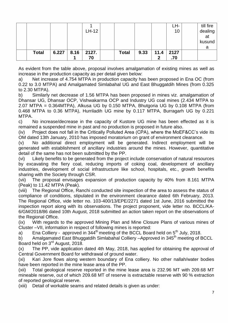
Agenda No.36.2 Expansion of Cluster VII from 8.16 MTPA peak to 11.42 MTPA peak capacity in mine lease area of 2127.7 ha of M/s Bharat Coking Coal Limited, located in Jharia Coalfields, District Dhanbad (Jharkhand) - For EC 36.2.1 The proposal is for environment clearance to the project for expansion of Cluster VII from 8.16 MTPA (peak) to 11.42 MTPA (peak) of M/s Bharat Coking Coal Limited in mine lease area of 2127.7 ha located in Jharia Coalfields, District Dhanbad (Jharkhand). 36.2.2 Facts of the proposal, as ascertained from the proposal documents and revealed from the discussions held during the meeting are given as under: (i) The project is located in Kusunda village, Dhanbad District (Jharkhand) between coordinates 23°44'42.00" to 23°43'7.16"N and 86°25'40.67" to 86°23'27.23"E. Soft copy of the KML file, indicating the project location, has been submitted by the PP. However, KML files corresponding to the individual mines of the group have not been submitted by the PP. (ii) Integrated environment clearance for Cluster VII Group of mines was accorded by the MoEF&CC, vide letter dated 6th February, 2013 for 8.161 MTPA (Peak) capacity in mine lease area of 2127.70 ha. (iii) Detail of existing 14 mines of the Cluster –VII and proposed amalgamation of the mines is given as under:
Existing After onetime capacity enhancement (40%)
S. No
Name of Project
Prod. Capacity
(MTPA)
Peak
prod.
(MTPA)
ML Area (Ha)
Life of
Mine
(years)
Name of
Project
Prod. Capacity
(MTPA)
Peak
prod.
(MTPA)
ML Area (Ha)
Balance Life of
Mine (year
s)
Remarks
1 Dhansar UG
0.372 0.484
174.1
2 LH-1
34 Amalgamated Dhans
ar-Industr
y Colliery OC
1.60 2.07
276.62
LH-1
30 Fire excavation at Industr
y
2 Dhansar OC
0.800 1.040
2
3 Vishwakarma OC
0.700 0.910
43.5 (within Dhansar&Industry
11
4 Industry UG
-- -- 137.20
LH-2
-

6
5 South Jharia / Rajapur
OC
1.300 1.690
207.4
8 LH-3
20 South Jharia / Rajapu
r OC
1.300 1.690
207.48
LH-2
17 Fire Excava
tion continu
ing
6 Ena OC 0.170 0.221
181.3
0 LH-4
20 Ena OC
2.31 3.00 216.00
LH-3
25 Fire Excava
tion speed
up
7 Kusunda OC
2.00 2.600
247.70
LH-5
27 Kusunda OC
2.00 2.000
247.70
LH-4
23 Fire Excava
tion continu
ing
8 Alkusa UG
0.115 0.150
101.7
7 LH-6
30 Alkusa UG
- - 101.77
LH-5
- Inoperative till fire
dealing at
kusunda
9 Simlabahal UG
0.250 0.325
178.1
3 LH-7
20 Amalgamated
East Bhuggatdih
Simlabahal OC
1.76
2.30
420.75
LH-6
15
Fire Excava
tion
10 East Bhuggat
dih
-- -- 242.62
LH-8
-
11 Bhutgoria UG
0.360 0.468
131.67
LH-9
23 Bhutgoria UG
0.360 0.36 131.67
LH-7
23 Reopening
12 Hurriladih UG
0.090 0.117
127.1
7 LH-10
13 Hurriladih UG
- - 127.17
LH-8
- Inoperative till fire
dealing at
Simlabahal
13 Burragarh UG
0.170 0.221
147.8
3 LH-11
20 Burragarh UG
- - 147.83
LH-9
- Inoperative till fire
dealing at
Simlabahal
14 Kustore UG
-- -- 250.7
20 Kustore UG
-- -- 250.71
- Inoperative
7
1 LH-12
LH-10
till fire dealing
at kusund
a
Total 6.227 8.161
2127.70
Total 9.33 11.42
2127.70
As evident from the table above, proposal involves amalgamation of existing mines as well as increase in the production capacity as per detail given below: a) Net increase of 4.754 MTPA in production capacity has been proposed in Ena OC (from 0.22 to 3.0 MTPA) and Amalgamated Simlabahal UG and East Bhuggatdih Mines (from 0.325 to 2.30 MTPA). b) Similarly net decrease of 1.56 MTPA has been proposed in mines viz. amalgamation of Dhansar UG, Dhansar OCP, Vishwakarma OCP and Industry UG coal mines (2.434 MTPA to 2.07 MTPA = 0.364MTPA), Alkusa UG by 0.150 MTPA, Bhutgoria UG by 0.108 MTPA (from 0.468 MTPA to 0.36 MTPA), Hurriladih UG mine by 0.117 MTPA, Burragarh UG by 0.221 MTPA. c) No increase/decrease in the capacity of Kustore UG mine has been effected as it is remained a suspended mine in past and no production is proposed in future also. (iv) Project does not fall in the Critically Polluted Area (CPA), where the MoEF&CC’s vide its OM dated 13th January, 2010 has imposed moratorium on grant of environment clearance. (v) No additional direct employment will be generated. Indirect employment will be generated with establishment of ancillary industries around the mines. However, quantitative detail of the same has not been submitted by the PP. (vi) Likely benefits to be generated from the project include conservation of natural resources by excavating the fiery coal, reducing imports of coking coal, development of ancillary industries, development of social infrastructure like school, hospitals, etc., growth benefits sharing with the Society through CSR. (vii) The proposal envisages expansion of production capacity by 40% from 8.161 MTPA (Peak) to 11.42 MTPA (Peak). (viii) The Regional Office, Ranchi conducted site inspection of the area to assess the status of compliance of conditions, stipulated in the environment clearance dated 6th February, 2013. The Regional Office, vide letter no. 103-400/13/EPE/2271 dated 1st June, 2016 submitted the inspection report along with its observations. The project proponent, vide letter no. BCCL/KA-6/GM/2018/86 dated 10th August, 2018 submitted an action taken report on the observations of the Regional Office. (ix) With regards to the approved Mining Plan and Mine Closure Plans of various mines of Cluster –VII, information in respect of following mines is reported: a) Ena Colliery - approved in 344th meeting of the BCCL Board held on 5th July, 2018. b) Amalgamated East Bhuggatdih Simlabahal Colliery –Approved in 345th meeting of BCCL Board held on 3rd August, 2018. (x) The PP, vide application dated 4th May, 2018, has applied for obtaining the approval of Central Government Board for withdrawal of ground water. (xi) Kari Jore flows along western boundary of Ena colliery. No other nallah/water bodies have been reported in the mine lease area of the PP. (xii) Total geological reserve reported in the mine lease area is 232.96 MT with 209.68 MT mineable reserve, out of which 209.68 MT of reserve is extractable reserve with 90 % extraction of reported geological reserve. (xiii) Detail of workable seams and related details is given as under:

8
S. No.
Name of the Mine Number of workable seams
Combined Thickness (m)
Coal Grade
Stripping ratio
Average gradient
1. Amalgamated East Bhuggatdih Simlabahal
17 95.42 S-II-W-IV 6.77 40-100
2. Amalgamated Dhansar Industry Colliery
12 71.97 W-III to G-1,12
4.05 30-100
3. Ena OC 17 114.13 S-II to G-6, 11
3.47 50-100
4. Kasunda OC 6 33.76 W-IV to NLW-III
4.487 50-60
5. Rajapur/South Jharia OCP
9 63.98 S-I to G-3, 11
8.70 50-100
(xiv) Availability of ground water has been reported to be varying between 0.70 m - 19.20 m during pre-monsoon season and between 0.10 m to 15.63 m during post-monsoon season. Existing water requirement for the project is 27,251 KLD while additional water of 1,720 KLD will be required for the proposed expansion project, thereby increasing the total water requirement to 28,971 KLD. (xv) Mining method envisages opencast mining using shovel-dumper combination. (xvi) Life of mines varies from 15 years to 30 years. (xvii) Ambient air quality seasonal data has been documented for the period of 19th March 2011 to 18thJune 2011. (xviii) Transportation of coal has been proposed through railways and road. (xix) Land use details, as made available by the PP, is given as under:
S. No.
Type of Land Use Present land
use (ha) Post-mining land use (ha)
1 Running Quarry Backfilled 235.77 0
Not Backfilled 143.63 424.01
2 Abandoned quarry Backfilled 41.97 5.39
Not Backfilled 26.09 0
3 External OB dump 35.80 0
4 Service building/ Mine Infrastructure
23.29 11.76
5 Coal dump 11.82 6.46
6 Rail and Road 65.39 45.11
7 Homestead Land 268.19 128.62
8 Agricultural Land 0.00 0.00
9 Forest Land 0.00 0.00
10 Plantation / reclamation 242.21 1028.68
11 Water Body 25.43 63.30
12 Barren Land 1008.11 385.12
13 Others (Peripheral haul road) 0.00 29.25
Total 2127.70 2127.70

9
Post - mining
S. No.
Name of the Mine
Mine void Area (ha)
Depth (m)
Total quarry area to be
reclaimed (ha)
Total quarry area to be
reclaimed (ha)
1. Amalgamated East Bhuggatdih Simlabahal
157.50 265-300 157.50 157.50
2. Amalgamated Dhansar Industry Colliery
12.67 210 212.93 119.48
3. Ena OC 42.77 275 179.44 179.44
4. Rajapur/South Jharia OCP
4.58 190 133.47 133.47
5. Kasunda OC - - 201.45 201.45
(xx) Details of external over burden dumps (OBs) and internal OBs, is given as under:
S. No.
Name of the Mine
Nos of external OBs
Area (ha)
Height (m)
Quantity (Mm3)
No. of Internal Dumps
Area (ha)
Height (m)
Quantity (Mm3)
1. Amalgamated East Bhuggatdih Simlabahal
2 216.09
90 101 - - - -
2. Amalgamated Dhansar Industry Colliery
1 160 90 78.94 1 119.48
90 104.34
3. Ena OC 2 296.69
30, 90
177.95 - - - -
4. Rajapur/South Jharia OCP
1 180 90 89.39 1 71.60
30 29.16
5. Kasunda OC - - - - 1 201.45
90 265
6. Total 6 852.78
- 447.28 3 392.53
- 398.5
(xxi) No forest land is involved in the project. (xxii) No National Park, Wildlife Sanctuaries, Eco-sensitive Zones are located within 10 km from the mine lease boundary. (xxiii) Total capital investment of the project as per approved Project Report is Rs. 18,947.63 lakh. However, detail of cost proposed to be incurred on environment management, CSR, etc has not been submitted by the PP. (xxiv) Information on R&R, if any, involved in the proposal, has not been furnished by the PP. (xxv) As per detail provided by the PP, the proposal is not subjected to any investigation. (xxvi) No court cases, violation cases are pending against the project of the PP.
10
(xxvii) It is further mentioned that the project was not listed before the Inter-Ministerial Group of the Ministry of Coal for any irregularities.
36.2.3 The EAC, after deliberations, noted the following:- The proposal is for environment clearance to the project for expansion of Cluster VII (Group of 14 OC/UG mines) from 8.16 MTPA (peak) to 11.42 MTPA (peak) of M/s Bharat Coking Coal Ltd in total mine lease area of 2127.7 ha located in Jharia Coalfields, District Dhanbad (Jharkhand). The expansion project mainly involves (a) amalgamation of Dhansar UG, Dhansar OCP, Vishwakarma OCP and Industry UG coal mines with the combined production capacity reducing from 2.434 MTPA to 2.07 MTPA in an area of 276.62 ha (b) amalgamation cum expansion of Simlabahal UG and East Bhuggatdih from 0.325 MTPA to 2.30 MTPA in an area of 420.75 ha (c) increase in production capacity of Ena OCP from 0.221 to 3.00 MTPA. There is no forest land is involved under the project. No National Park, Wildlife Sanctuaries, Eco-sensitive Zones are located within 10 km from the project site. The proposal seeks environmental clearance under the provisions contained in para 7(ii) of the EIA Notification, 2006, without any ToR for the project and fresh public hearing. Mining Plans including Mine Closure Plan have been revised/prepared for amalgamated Dhansar UG, Dhansar OCP, Vishwakarma OCP & Industry UG coal mines, Ena Colliery and Amalgamated East Bhuggatdih Simlabahal Colliery and reported to have been approved by the M/s BCCL Board on 5th July, 2018 & 3rd August, 2018, respectively. Earlier, the Cluster VII project for its capacity of 8.161 MTPA in a total area of 2127.70 ha was granted environmental clearance by the Ministry vide letter dated 6th February, 2013 based on the public hearing was conducted on 25th January, 2012. The Regional Office, Ranchi conducted site inspection of the area to monitor compliance of conditions, stipulated in the environment clearance dated 6th February, 2013 and submitted report vide their letter dated 1st June, 2018 along with their observations. The project proponent, vide their dated 10th August, 2018 submitted action taken report on the observations of the Regional Office, which was found to be satisfactory. During the period 2014-15 and 2015-16, coal production from Vishwakarma OCP (one of the coal mine in the Cluster) has been more than the sanctioned capacity of 0.91 MTPA, reportedly due to excavation of coal for liquidation of fire. However, combined production from the cluster during that period was 5.546 MTPA and 5.019 MTPA respectively which is within the approved capacity of 8.161 MTPA stipulated in the environment clearance dated 6th February, 2013. Coal mine fire is prevalent in amalgamated Dhansar Industry OC, Ena OC, Simlabahal, East Bhuggadih UG, Rajapur OC, Alkusa OC, Kasunda OC and in Kustore UG which needs to be rehabilitated. Further, coal in proposed amalgamated Dhansar, Ena and Amalgamated East Bhuggatdih, Rajapur and Kusunda needs to be de-coaled to control raging fire. 36.2.4 The Committee, after detailed deliberations and in exercise of the provisions contained in para 7(ii) of the EIA Notification, 2006 and giving special consideration for the fire-affected status of these mines and the urgency for de-coaling as part of fire control operations,

11
exempted the project from prescribing ToR and the public hearing, and recommended grant of environmental clearance to the project for expansion of Cluster VII Coal Mining project from 8.16 MTPA (peak) to 11.42 MTPA (peak) of M/s Bharat Coking Coal Limited in combined mine lease area of 2127.7 ha, located in Jharia Coalfields, District Dhanbad (Jharkhand), subject to the compliance of terms and conditions as applicable, and the additional conditions as under:-
The project proponent shall obtain Consent to establish from the State Pollution Control Boards of Jharkhand for the proposed peak capacity of 11.42 MTPA prior to commencement of the increased production.
Transportation of coal from face to Coal heap shall be carried out by truck. Further, the coal transportation from Coal heap to Coal Handling Plant shall be carried out through covered trucks.
Mitigative measures to be undertaken to control dust and other fugitive emissions all along the roads by providing sufficient numbers of water sprinklers.
Sufficient coal pillars shall be left un-extracted around the air shaft (within the subsidence influence area) to protect from any damage from subsidence, if any.
Solid barrier shall be left below the roads falling within the block to avoid any damage to the roads and no depillaring operation shall be carried out below the township/colony.
Depression due to subsidence resulting in water accumulating within the low lying areas shall be filled up or drained out by cutting drains.
Sufficient number of pumps of adequate capacity shall be deployed to pump out mine water during peak rain fall.
The company shall obtain approval of CGWA for use of groundwater for mining operations at its enhanced capacity of 11.42 MTPA.
Continuous monitoring of occupational safety and other health hazards, and the corrective actions need to be ensured.
The fire dealing operations by excavating out fire should be expedited. Agenda No.36.3 Coal Washery of 2.5 MTPA in an area of 9.85 ha of M/s Paras Power & Coal Beneficiation Limited, located Village Ghutku, Tehsil Takhatpur, District Bilaspur (Chhattisgarh) - For EC 36.3.1 The proposal is for environment clearance for setting up of a Coal Washery of 2.5 MTPA in an area of 9.85 ha of M/s Paras Power & Coal Beneficiation Limited, located in village Ghutku, Tehsil Takhatpur, District Bilaspur (Chhattisgarh). 36.3.2 Facts of the proposal, as ascertained from the proposal documents and revealed from the discussions held during the meeting are given as under:- (i) The Terms of Reference (TOR) was issued vide MoEF&CC letter no. J-11015/70/2004-lA.ll (M) dated 6th June, 2016. Subsequently, M/s PPCBL sought change in the area from 24.26 acres to 19.77 acres which was approved by EAC vide MoEF&CC letter no. J-11015/70/20016-lA.ll (M) dated 30thNovember 2017. (ii) The latitude and longitude of the project are:
Latitude 22°08’9.17” N to 22°09’2.84” N Longitude 82°05’21.74” E to 82°05’31.95” E
(iii) Joint Venture: There is no joint venture.

12
(iv) Coal Linkage: MOU signed with M/s Ultratech Cement Limited and M/s Jaiprakash Power Ventures Ltd., M/s JK Lakshmi Cement Ltd., and M/s Lanco Anpara Power Ltd. (v) Employment generation/to be generated: About 200 persons for construction and 65 persons during operation & maintenance (vi) Benefits of the Project: Beneficiation of low grade coal is an important area both from the economic and the environment point of view. The project will encourage ancillary industries in the region, which will increase the employment potential. The economic base of the region will be further strengthened. (vii) The total land required for the proposed coal washery plant is 19.77 acres (8 ha). 95% of the project land is under possession of PPCBL (viii) The land usage of the project will be as follows:
S. No. Particulars Area (in acres)
1 Washery Plant 7.00
2 Raw Coal Stockyard 1.42
3 Clean coal, middling & Rejects 3.75
4 Other facilities – Office building, Internal roads, Weigh bridge, Water reservoir, Canteen, Labourer room, Maintenance shed, Stores etc.
1.67
5 Plantation 5.93
Total 19.77
(ix) Water requirement of 61 m3/hr, which includes 4m3/hr of domestic demand, will be met from the ground water source. RCC water reservoir of around 5000 m3 storage capacity will be constructed. NOC from the Central Ground Water Authority has been obtained vide letter no. 21-4/336/CT/IND/2016 -2576 dated 18th November, 2016. (x) Washing Technology – Heavy Media Cyclone (xi) The seasonal data for ambient air quality has been documented and all results at all stations are within the prescribed limits. (xii) The ambient air quality monitoring was carried out from 1st March, 2016 to 31st May, 2016 representing pre-monsoon season. All PM10, PM2.5, SO2 and NOX values are found to be well within prescribed limits of CPCB. (xiii) Transportation: ROM coal from SECL mines will be transported by road. Efforts will be made to bring some coal by rail. Maximum coal evacuation from the washery will be from own railway siding at Ghutku which will be made operational before the establishment of 2.5 MTPA project. (xiv) Cost: The estimated cost of the proposed project is about Rs. 24 crores excluding cost of EMP, land and railway sliding at Ghutku. (xv) CSR cost: It is proposed to invest a sum equivalent to 2% of the net profit or an amount of Rs. 10 lakhs, whichever is higher annually for various social welfare and community development activities in the region (xvi) EMP Cost: Rs. 1.50 crores is earmarked towards environmental protection measures. (xvii) Nearest Water bodies: 2.5 km from Arpa River and 7.2 km from GhonghaNadi (xviii) Ground Water Clearance: NOC from the Central Ground Water Authority has been obtained vide letter no. 21-4/336/CT/IND/2016 -2576 Dated 18th Nov 2016. (xix) Wild Life issues: There are no national parks, wildlife sanctuaries, biospheres reserves found in 10 km buffer zone. (xx) Forestry issues: No forest issues involved (xxi) Greenbelt: 30% of the project area will be developed on greenbelt using nature plant species at the rate of 2500 trees per ha

13
(xxii) There are no court cases/violation pending with project proponent (xxiii) Public Hearing was held on 9th March, 2018 at Ghanapara Basti near Ghutku village, Takhatpur Tehsil, Bilaspur district (CG). The issues raised during PH includes employment, infrastructure development, drinking water facilities, education and health. 36.3.3 The proposal was considered by the sectoral EAC in the Ministry in its 32nd meeting held on 28th June, 2018. Parawise reply given by the project proponent vis-a-vis their observations is as under:-
S. No.
Reply
1. Raw coal from the linked coal mines of M/s SECL is proposed to be taken to coal washery by road covering the distance ranging 51-61 km. Traffic density on the said road reported to be already on the higher side, the Committee insisted for other means of coal transportation also needs to be explored. In addition, the Committee desired that carrying capacity assessment of the said road vis-à-vis the environmental concerns shall be carried out from some reputed government agency to deliberate on the matter.
With regards to the carrying capacity of the road, it is submitted that coal is dispatched by road from Gevra, Deepkaand Kusmunda mines through NH-130 (Bilaspur-Katghora-Ambikapur). A detailed traffic study was conducted on behalf of the Government to augment the capacity of Bilaspur-Katghora Section section of NH-130 for efficient movement of traffic for next 30 years. The survey focused on traffic pattern besides other factors. Final report was submitted by the consultants to NHAI in October, 2017. It is further mentioned by the PP that Gevra, Dipka, Kusmunda and Korba mines in Sub-Korba coalfields evacuates coal by using Rail, Road, Belt, MGR and own wagons. Presently, most of the coal from these mines is evacuated by road. Coal from the Gevra, Dipka and Kusmunda mines coming towards Bilaspur & Raipur is transported via Pali – Dipka PWD road and Bilaspur – Katghora road (NH130). PWD completed widening of Pali – Dipka two lane road with cement concrete pavement in 2016. NHAI is upgrading a stretch of NH130 from 2 lane to 4 lane with paved shoulders. Work is in progress. Based on the traffic study recommendations, the State Government decided to augment the capacity of the Bilaspur – Katghora section of NH130 from 2lane with paved shoulders to 4lane with paved shoulders for efficient movement of traffic considering next 30 years traffic requirement.
2. Detailed schematic diagram of washing process including performance parameters i.e. mass-energy balance for each stage of coal washing, starting from crushing/screening passing through washing process, would
Schematic diagram of washing process including performance parameters i.e. mass-energy balance for each stage of coal washing, starting from crushing/screening passing through washing process, would be required to firm up the yield, actual quantum of washed coal and disposal of rejects has been submitted by
14
be required to firm up the yield, actual quantum of washed coal and disposal of rejects.
the PP.
36.3.4 During deliberations, the Committee noted the following:- The proposal is for environmental clearance to Coal Washery of 2.5 MTPA of M/s Paras Power & Coal Beneficiation Ltd in an area of 19.77 acre at Ghutku Village, Tehsil Takhatpur, District Bilaspur (Chhattisgarh). There is no forest area involved. ToR for the project was granted by the Ministry on 6th June, 2016 which was amended on 30th
November 2017 for reduction in project area from 24.26 acre to 19.77 acre. Public hearing was conducted by the State Pollution Control Board on 9th March, 2018. Main issues raised during public hearing include employment, infrastructure development, drinking water facilities, education and health etc. Total fresh water requirement is estimated to be 1464 cum/day, which includes 96 cum/day for domestic demand, will be met from the ground water source. NOC from the Central Ground Water Authority has been obtained vide letter No.21-4/336/CT/IND/2016-2576 dated 18th November, 2016. A study report on the carrying capacity of the road proposed for the transportation of coal to the washery of PP and schematic diagram of washing process have been submitted by the PP and the same found satisfactory. and Raw coal from the linked coal mines of M/s SECL is proposed to be taken to coal washery by road covering the distance ranging 51-61 km. Traffic density on the said road reported to be already on the higher side, the Committee insisted for other means of coal transportation also needs to be explored. In addition, the Committee desired that carrying capacity assessment of the said road vis-à-vis the environmental concerns shall be carried out from some reputed government agency to deliberate on the matter. Detailed schematic diagram of washing process including performance parameters i.e. mass-energy balance for each stage of coal washing, starting from crushing/screening passing through washing process, would be required to firm up the yield, actual quantum of washed coal and disposal of rejects. 36.3.5 The Committee, after deliberations, recommended grant of environment clearance to Coal Washery of 2.5 MTPA in an area of 9.85 ha of M/s Paras Power & Coal Beneficiation Limited, located Village Ghutku, Tehsil Takhatpur, District Bilaspur (Chhattisgarh) under the provisions of the Environment Impact Assessment Notification, 2006 and subsequent amendments/circulars thereto subject to the compliance of the following terms & conditions and environmental safeguards mentioned below:
Consent to Establish under the Water Act, 1974 and the Air Act, 1981 shall be obtained from the State Pollution Control Board prior to setting up the required infrastructure.
The washery shall be as per project report submitted and presented to EAC.
Transportation of coal from mine to the washery shall be carried out through conveyor belts, and then to the prospective consumers/TPP by rail through silo.
Mitigative measures to be undertaken to control dust and other fugitive emissions all along

15
the roads by providing sufficient numbers of water sprinklers The technology so chosen should conform to ‘Zero Liquid Discharge’.
Continuous monitoring of occupational safety and other health hazards, and the corrective actions need to be ensured.
More locations (4-5 nos) to be identified in downwind areas in the buffer zone for ambient air quality monitoring in consultation with the State Pollution Control Board.
Disposal of washery rejects shall be in accordance with the extant policy and guidelines, and environment friendly.
Thick green belt of 30-45 m width to be provided around the washery to mitigate/check the dust pollution. A 3-tier avenue plantation should also be developed along vacant areas, storage yards, loading/transfer points, and also along internal roads/main approach roads.
Agenda No.36.4 Bhatadi OC Expansion from (0.975 MTPA to 1.465 MTPA Peak in an ML area of 847.37 ha. of M/s Western Coalfields Limited, located in Village Bhatadi, District Chandrapur (Maharashtra) - For EC 36.4.1 Proposal is for expansion of Bhatadi OC from 0.975 MTPA to 1.465 MTPA in mine lease area of 847.367 ha of M/s Western Coalfields Limited, located in Village Bhatadi, District Chandrapur (Maharashtra) 36.4.2 Facts of the proposal, as ascertained from the proposal documents and revealed from the discussions held during the meeting are given as under: (i) The project is located in Bhatadi village, in Wardha Valley Coalfields in Chandrapur district. The nearest rail head is Tadali which is about 8 to 9 km away from the mine and Chandrapur Station about 15 km away from the mine. Both the stations are on the main line of Central Railway. (ii) The project area falls in Survey of India Topo Sheet No.55 P/08 with geographical coordinates ranging from 200 02' 27" - 200 04’' 25" E and longitudes 790 15' 18" -790 17' 35" N. (iii) Coal linkage of the Bhatadi OC mainly lies with Thermal Power Plants of MAHAGENCO. In addition to this coal from the mine will be provided to other miscellaneous consumers. (iv) No joint venture cartel has been formed to operate the mine. Bhatadi OC Expansion Mine Project has been proposed to be operated solely by the M/s WCL. (v) Project does not fall in the Critically Polluted Area (CPA), where the MoEF&CC’s vide its OM dated 13th January, 2010 has imposed moratorium on grant of environment clearance. (vi) With regards to employment generation, it is mentioned that no additional employment from the expansion project will be generated. Existing manpower engaged in the project is reported to be 474 persons. (vii) The project is reported to be beneficial to bridge the gap between demand and supply of non-coking coal for the power houses and other bulk consumers of western region as well as southern part of the country. (viii) The Bhatadi Expansion OC mine has been divided into two quarries namely, Quarry-I and Quarry-II. Presently Quarry-I is operational while area of Quarry-II is virgin as per detail given below:
S. No. Particulars Quarry-I Quarry-II Total
1 Area of the Quarry
a) On floor (ha) 50.870 33.875 84.745

16
S. No. Particulars Quarry-I Quarry-II Total
b) On surface (ha) 88.92 72.60 161.52
2 Depth (m)
a) Initial 33 53
b) Final 150 150 -
3 Average gradient of Seam 1 in 6 1 in 6
4 Average thickness of seam (m) 17 17
5 Average strike length (m) 800 700
6 Width on surface (m) (Dip Rise) 700 850
7 Width on floor (m) (Dip Rise) 500 600 -
8 GCV (k Cal/ kg) (Overall) 4504 (G-10)
9 Balance Mineable reserves (Mt) as on 1/4/2017
3.54 9.27 12.81
10 Total OB including Access Trench (Mm3) as on 1/ 4/2017
19.78 51.07 70.85
11 Average Stripping ratio in m3/t. as on 1/ 4/2017
5.59 5.51 5.53
(ix) Erai River and its tributaries flow in the area of Bhatadi OC Expansion. The general elevation of the area varies between 184 m and 212 m above mean sea level with slope towards South-East. (x) The calendar programme of excavation and OB dumping is as follows:
S. No.
Year Production
(Mt)
OB Dumping (Mm3) SR
Internal External Total
1. 2017-18 0.97 0 5.364 5.364 5.53
2. 2018-19 1.4625 5.92 2.167 8.087 5.53
3. 2019-20 1.4625 6.72 1.367 8.087 5.53
4. 2020-21 1.4625 6.72 1.367 8.087 5.53
5. 2021-22 1.4625 6.72 1.367 8.087 5.53
6. 2022-23 1.4625 6.72 1.367 8.087 5.53
7. 2023-24 1.4625 6.72 1.367 8.087 5.53
8. 2024-25 1.4625 6.72 1.367 8.087 5.53
9. 2025-26 1.4625 6.72 1.367 8.087 5.53
10. 2026-27 0.153 0.79 0.00 0.79 5.16
Total 12.823 53.75 17.10 70.85 5.53
Last 5 years production is as given below (All figures in Million Tonnes per Annum)
S. No. Year Coal Production EC capacity
1. 2016-17 0.875 0.975
2. 2015-16 0.71 0.975
3. 2014-15 0.71 0.975
4. 2013-14 0.57 0.65
5. 2012-13 0.49 0.65
(xi) The land usage pattern of the project is as follows:
Pre-mining land use details
S. Particulars Tenancy Govt. Forest Total

17
No. Land (ha) Land (ha)
Land (ha)
(ha)
1 Land Already acquired by existing Bhatadi Expansion OC Mine (ha)
785.69 52.25 0.00 837.94
2 Land for Bhatadi Village Rehabilitation to be Acquired
9.43 0.0 0.0 9.43
Total 795.12 52.25 0.0 847.37
Note: Out of this, land acquired till date is 837.94 ha. Post Mining
S.N. Land use during
mining
Land use (ha)
Plantation Water Body
Public use
Undisturbed Total
1 Backfilled Area 50.00 38.92 0.00 0.00 88.92
2 Excavated Area 0.00 72.4 0.00 0.00 72.40
3 Embankment Area 13.00 0.00 0.00 0.00 13.00
4 External OB dump 142.10 0.00 0.00 0.00 142.10
5 Colony, Infrastructure etc.
6.00 0.00 21.60 0.00 27.60
6
Miscellaneous (Blasting zone, river diversion, power line diversion & rationalization
50.00 0.00 0.00 435.47 485.47
7 Road 3.00 0.00 5.45 0.00 8.45
Total 264.10 111.32 27.05 435.47 837.94
(xii) Total geological reserve reported in the mine lease area is 45.714 MT with 23.566 MT mineable reserve, out of which 12.81 MT of reserve is extractable reserve with extraction intensity of 95 %. (xiii) The mining plan has been approved by WCL Board vide letter no. WCL/BD/Sectt/BM-293/2017/936 dated 10th November, 2017. (xiv) Application for obtaining the approval of the Central Ground Water Authority for dewatering of groundwater has been submitted on 26th May, 2016. Updated status of the same has not been provided by the PP. (xv) Erai River has its course through the mine lease of the project. The proposal for diversion Erai river has been submitted to CDO, Nasik and their team is expected to visit site and further action will be taken as per their advice. (xvi) Availability of ground water has been reported to be varying between 3.3 m – 13.28 m during pre-monsoon season and between 0.10 m to 13.15 m during post-monsoon season. Total water requirement for the project has been reported to be 222 KLD. (xvii) One composite seam with thickness ranging between 15.78 – 20.83 meters has been reported to be workable. Grade of coal is G-10, stripping ratio 1:5.53, while gradient is 1 in 6. (xviii) Method of mining envisages opencast with shovel-dumper combination.

18
(xix) Life of mine has been reported to be 9 years. (xx) The project has 2 external OB dumps in an area of 142 ha with 60 m height and 17.10 Mm3 of OB and one internal OB in an area of 88.92 ha with proposed height of 60 m and 53.75 height Mm3 of OB. (xxi) Total quarry area is 161.32 ha out of which backfilling will be done in area of 88.92 ha while final mine void will be created over an area of 111.32 ha with a depth of 150 m. Similarly, out of 88.92 ha of backfilled area, 50 ha area has been proposed to be reclaimed by plantation. Final mine void will be converted into a water body. (xxii) Afforestation plan over a total area of 264.10 ha has been proposed to be implemented by the end of mining operations with density of 2500 plants per ha. It is further mentioned that implementation of the Progressive Mine Closure Plan is being taken up by the PP as per the approved Plan and there is no deviation from the approved Plan. (xxiii) The PP has reported no court cases, violation cases are pending. (xxiv) The Regional Office (WCZ), Nagpur conducted site inspection of the area to assess the status of compliance of conditions, stipulated in the environment clearance dated 19th March, 2015. The Regional Office, vide letter no. 3-16/2015/3202 dated 5th February, 2018 submitted inspection report along with its observations. (xxv) As per approved Mining Plan, the lease area is 837.94 ha. However, additional area of 20.2 ha, including 0.20 ha of forest land, is also required outside the lease area for the settlement of Bhatadi village. However, the present proposal has been limited to the existing lease area of 837.94 ha as per existing EC. (xxvi) No forest land has been reported to be involved in the project. However, an area of 0.20 ha of forest land is involved in the project which, along with 20 ha of additional land, has been proposed to be acquired for the resettlement and rehabilitation of Bhatadi village. (xxvii) The project involves 820 project affected families. (xxviii) Total cost of the project is Rs. 304.5162 crores, cost of production is kept at Rs. 3,279.87 per tonne, CSR cost is Rs. 2 per tonne, R&R cost is 79.79 crores. Environment Management Cost is Rs. 0.9709 crores. (xxix) Transportation of coal in mine pit head has been proposed by dumpers, surface to sidings by tippers at siding by Pay loader. The PP has also mentioned that construction of piped conveyor is in advance stage. (xxx) Public hearing was conducted on 20th July, 2004 at Bachatsafalata Bhawan, Collectorate, Chandrapur. (xxxi) Earlier, Bhatadi OC expansion project was accorded environment clearance on 19th May March, 2015 from 0.65 to 0.975 MTPA in a total lease area of 847.37 ha. Now, the PP has proposed to increase production by 40 % i.e. 0.39 MTPA applied from 0.975 to 1.365 MTPA. 36.4.3 The proposal was earlier considered by the EAC in its meeting held on 17-18 April, 2018. During the meeting, the Committee noted that the last public hearing for the project was conducted by the State Pollution Control Board on 20th July, 2004 i.e. much before the inception of the EIA Notification, 2006 presently in force. The Committee desired for compliance of the present provisions of the said Notification, and insisted for fresh public hearing for the proposed expansion from 0.975 MTPA to 1.465 MTPA, even if the project area remains same. Based on the recommendation of the EAC, the proposal was not taken forward. 36.4.4 The Committee, after detailed deliberations, observed that their recommendation during the meeting held on 17-18 April, 2018 in respect of conducting fresh public hearing is yet to be complied with. The Committee insisted for the same for further consideration of the proposal. The proposal was therefore deferred for the needful on the above lines.

19
Agenda No.36.5 Expansion of Umrer OC Project from 3.50 MTPA to 4.90 MTPA in mine lease area of 944.65 ha of M/s Western Coalfields Limited, located in Village Kanwa, Tehsil Umrer, District Nagpur (Maharashtra) - For EC 36.5.1 The proposal is for expansion of Umrer OC Project from 3.50 MTPA to 4.90 MTPA in mine lease area of 944.65 ha of M/s Western Coalfields Limited, located in Village Kanwa, Tehsil Umrer, District Nagpur (Maharashtra) 36.5.2 Facts of the proposal, as ascertained from the proposal documents and revealed from the discussions held during the meeting are given as under: (i) The proposal is for grant of environment clearance for expansion of Umrer OC Project from 3.50 MTPA to 4.90 MTPA in mine lease area of 944.65 ha of M/s Western Coalfields Limited, located in Village Kanwa, Tehsil Umrer, District Nagpur (Maharashtra). (ii) The project area falls in Survey of India Topo Sheet No.55 P/05 with geographical coordinates ranging from 20°50'56" - 20°52'58"N and 79°15'55"-79°18'9" E. Mine falls in Umrer block of Umrer Coalfields in Nagpur district. The mine is situated at 45 K.M. South–East of Nagpur and easily approachable by all Maharashtra State High way No. 9. For coal transport this mine is connected by a broad gauge railway siding to Butibori Railway Station in Nagpur- Wardha Section of Central Railway. (iii) Umrer OC mine was started in the year 1962. Environment clearance for production capacity of 3.50 MTPA within mine lease area of 944.65 ha was accorded by the Ministry vide letter dated 20th May, 2005. (iv) Coal linkage of the Umrer OC Project mainly lies with Thermal Power Plants of MAHAGENCO. In addition to this coal from the mine will be provided to other miscellaneous consumers. (v) No joint venture cartel has been formed to operate the mine. Umrer OC Expansion Mine Project has been proposed to be operated solely by the M/s WCL. (vi) Project does not fall in the Critically Polluted Area (CPA), where the MoEF&CC’s vide its OM dated 13th January, 2010 has imposed moratorium on grant of environment clearance. (vii) With regards to employment generation, it is mentioned that existing manpower engaged in the project is reported to be 1,036 persons. (viii) The project is reported to be beneficial to bridge the gap between demand and supply of non-coking coal for the power houses and other bulk consumers of western region as well as southern part of the country. (ix) The Regional Office (WCZ), Nagpur conducted site inspection of the area in Febraury, 2018 to assess the status of compliance of conditions, stipulated in the environment clearance dated 20th May, 2005. The Regional Office, vide letter no. 3-16/2015/3202 dated 7th February, 2018 submitted inspection report along with its observations. The action taken report has been submitted by the PP to RO, MoEF& CC, Nagpur on 2nd July, 2018 (x) Land use detail of the mine is given as under:
During Mining:
S. No
Particulars Existing land use as on 1st April,2018 (ha)
Land use during mining (ha)
1 Quarry area 319.60 362.00
2 External OB Dump 139.52* 139.52*

20
3 Infrastructure including road and colony
227.69 227.69
4 Blasting Zone and Rationalization 257.84 215.44
Total 944.65 944.65
*The area includes 32.88 ha External Dump of Makardhokra-II OC also as recorded in EC granted to Makardhokra-II OC dated 10th February, 2009. Post mining:
S.N. Land use during mining
Land use (ha)
Plantation Water Body
Public use
Undisturbed Total
1 External OB Dump
139.52 - - - 139.52
2 Top soil dump - - - - -
3 Excavation 150.0 95.52 - 116.48* 362.00
4 Built up area including Road & Township
20.0 - - 207.69 227.69
5 Green Belt - - - - -
6 Undisturbed Area
88.36 - - 127.08 215.44
Total 397.88 95.52 - 451.25 944.65
116.48* land will be technically reclaimed and stabilized. (xi) Total geological reserve reported in the mine lease area is 11.68 MT and entire geological reserve available in the mine lease is extractable. Therefore, extraction percentage is 100%. (xii) Mining Plan for a production capacity of 4.90 MTPA within the existing mine lease area of 944.65 ha has been approved by WCL Board in its 300th meeting held on 24th May, 2018. The Mine Plan Mine Closure Plan also. (xiii) Application for obtaining the approval of the Central Ground Water Authority for dewatering of groundwater has been submitted on 13th June, 2016. Updated status of the same has not been provided by the PP. (xiv) Amb river flow through the project area. It has been diverted from southern part of the quarry to northern part of quarry for a length of 2.4 kms. Availability of ground water has been reported to be varying between 2.2 m – 10.4 m during pre-monsoon season and between 3.35 m to 10.2 m during post-monsoon season. Total water requirement for the project has been reported to be 1126 m per day. (xv) Geo-mining parameters of the mine are given as under:
S. No Particulars Total quarry
1 Area of the Quarry
a) On floor (ha) 211.83
b) On surface (ha) 319.6
2 Depth (m)
a) Initial 26
b) Final 145
3 Average gradient of Seam 1 in 2 to 1 in 12
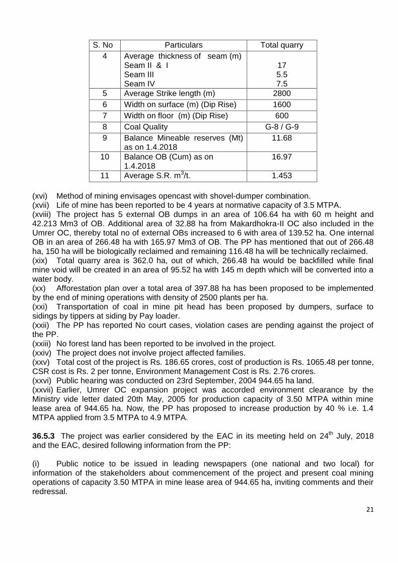
21
S. No Particulars Total quarry
4 Average thickness of seam (m) Seam II & I Seam III Seam IV
17 5.5 7.5
5 Average Strike length (m) 2800
6 Width on surface (m) (Dip Rise) 1600
7 Width on floor (m) (Dip Rise) 600
8 Coal Quality G-8 / G-9
9 Balance Mineable reserves (Mt) as on 1.4.2018
11.68
10 Balance OB (Cum) as on 1.4.2018
16.97
11 Average S.R. m3/t. 1.453
(xvi) Method of mining envisages opencast with shovel-dumper combination. (xvii) Life of mine has been reported to be 4 years at normative capacity of 3.5 MTPA. (xviii) The project has 5 external OB dumps in an area of 106.64 ha with 60 m height and 42.213 Mm3 of OB. Additional area of 32.88 ha from Makardhokra-II OC also included in the Umrer OC, thereby total no of external OBs increased to 6 with area of 139.52 ha. One internal OB in an area of 266.48 ha with 165.97 Mm3 of OB. The PP has mentioned that out of 266.48 ha, 150 ha will be biologically reclaimed and remaining 116.48 ha will be technically reclaimed. (xix) Total quarry area is 362.0 ha, out of which, 266.48 ha would be backfilled while final mine void will be created in an area of 95.52 ha with 145 m depth which will be converted into a water body. (xx) Afforestation plan over a total area of 397.88 ha has been proposed to be implemented by the end of mining operations with density of 2500 plants per ha. (xxi) Transportation of coal in mine pit head has been proposed by dumpers, surface to sidings by tippers at siding by Pay loader. (xxii) The PP has reported No court cases, violation cases are pending against the project of the PP. (xxiii) No forest land has been reported to be involved in the project. (xxiv) The project does not involve project affected families. (xxv) Total cost of the project is Rs. 186.65 crores, cost of production is Rs. 1065.48 per tonne, CSR cost is Rs. 2 per tonne, Environment Management Cost is Rs. 2.76 crores. (xxvi) Public hearing was conducted on 23rd September, 2004 944.65 ha land. (xxvii) Earlier, Umrer OC expansion project was accorded environment clearance by the Ministry vide letter dated 20th May, 2005 for production capacity of 3.50 MTPA within mine lease area of 944.65 ha. Now, the PP has proposed to increase production by 40 % i.e. 1.4 MTPA applied from 3.5 MTPA to 4.9 MTPA. 36.5.3 The project was earlier considered by the EAC in its meeting held on 24th July, 2018 and the EAC, desired following information from the PP: (i) Public notice to be issued in leading newspapers (one national and two local) for information of the stakeholders about commencement of the project and present coal mining operations of capacity 3.50 MTPA in mine lease area of 944.65 ha, inviting comments and their redressal.

22
(ii) Valid Mining Plan and the Mine Closure Plan duly approved by the competent authority, (iii) Compliance status of the conditions stipulated in the environmental clearance dated 20th May, 2005 from the Regional Office at Nagpur, (iv) Consent to operate from the State Pollution Control Board for the present mining operations, (v) Redressal of issues raised during the last public hearing conducted by the SPCB on 23rd September, 2004, along with the R&R details duly certified by the State Government, (vi) Details of court cases and the compliance status
36.5.4 The Committee, after detailed deliberations, observed that information sought by the EAC in its meeting held on 24th July, 2018 is yet to be furnished by the project proponent. The Committee insisted for the same for further consideration of the proposal. The proposal was therefore deferred for needful compliance of the observations of the Committee.
Agenda No.36.6 Pauni - II OC Coal Mine Project of 0.60 MTPA in an ML area of 316.30 ha of M/s Western Coalfields Limited, located in Village Pauni, District Chandrapur, (Maharashtra) - For EC Extension 36.6.1 The proposal is for revalidation of environment clearance accorded by the Ministry vide letter dated 2nd February, 2006 to Pauni - II OC Coal Mine Project of 0.60 MTPA capacity in an ML area of 316.30 ha of M/s Western Coalfields Limited, located in Village – Pauni, District Chandrapur, (Maharashtra) 36.6.2 Facts of the proposal, as ascertained from the proposal documents and revealed from the discussions held during the meeting are given as under: (i) The project area falls in Wardha Valley Coalfields and is located near village Skari, Rajura Tehsil in Chanderpur District. The prject area falls in Survey of India Topo Sheet No. 56 M/1 and 56M/5 with geographical coordinates ranging from 19°48'22"-19°49'37"N and 79°14'47"-79°16'14"E. (ii) Coal linkage of the Pauni-II OC Project mainly lies with Thermal Power Plants of MAHAGENCO. In addition to this coal from the mine will be provided to other miscellaneous consumers. (iii) No joint venture cartel has been formed to operate the mine. Pauni-II Mine Project has been proposed to be operated solely by the M/s WCL. (iv) Project does not fall in the Critically Polluted Area (CPA), where the MoEF&CC’s vide its OM dated 13th January, 2010 has imposed moratorium on grant of environment clearance. (v) With regards to employment generation, it is mentioned that existing manpower engaged in the project is 114. In addition to this 200 persons employed indirectly through contractors, (vi) The project is reported to be beneficial to bridge the gap between demand and supply of non-coking coal for the power houses and other bulk consumers of western region as well as southern part of the country. (vii) Total mine lease area is 316.30 ha, comprising of 301.37 ha of tenancy land and 14.93 ha of Government land. Land use detail of the mine is given as under:
During Mining:
S. No. Particulars Land Details (ha)
23
1 Quarry area 53.70
2 External OB Dump 75.40
3 Infrastructure 3.75
4 Road & Miscellaneous 30.00
5 Blasting zone 70.20
6 Future Expansion 60.10
7 Rationalization 23.15
Sub-Total 316.30
Post Mining
S.No. Land use during mining
Land use (ha)
Plantation Water Body
Public use
Undisturbed Total
1 External OB Dump
75.40 - - - 75.40
2 Excavation - 53.70 - - 53.70
3 Roads 5.0 - - - 30.0
4 Built up area 1.0 - 2.75 - 3.75
5 Green Belt Included in S. No 4, 5 & 7
6 Undisturbed Area 74.0 - - 79.45 153.45
Total 155.40 53.70 2.75 79.45 316.30
(viii) Total geological reserve reported in the mine lease area is 6.06 MT with mineable reserve of 5.18 MT out of which extractable reserve is 5.18 MT with extractable reserve percent of 85.47 % of the total reported geological reserve. (ix) The Project Report has been approved by the Board of WCL vide their letter dated 21st November, 2011. Mine Closure Plan of Pauni-II Expansion OC having total lease area of 1152.66, including 316.30 ha of existing Pauni-II OC, was approved by the Board of WCL on 29th September, 2016. (x) Application for obtaining the approval of the Central Ground Water Authority for withdrawal of groundwater has been submitted on 19th January, 2017. Updated status of the same has not been provided by the PP. (xi) Two seasonal nallah flow through mine lease of the PP. The PP has proposed diversion of nallah. However, detail of consultations, if any, made with the Water Resource Department, Government of Maharashtra has not been submitted by the PP. (xii) Availability of ground water has been reported to be varying between 3.36 m-13.55 m during pre-monsoon season and between 0.6 m to 13.20 m during post-monsoon season. Total water requirement for the project has been reported to be 350 KLD. (xiii) Single composite seam of thickness varying from 2.55- 4.30 m (bottom section) and 10.72 m- 10.95 m (top section) is workable. Maximum thickness of seam is 15.02 m. Grade of coal is G-9, stripping ratio is 1:6.49 and average gradient is 1 in 6 to 1 in 7. (xiv) Method of mining envisages opencast with shovel-dumper combination. (xv) Transportation of coal in mine pit head and from surface to sidings has been proposed by dumpers and at siding by Pay loader. (xvi) Life of mine has been reported to be 7 years. (xvii) The project has one external OB dumps in an area of 60.40 ha with maximum height of 90 m height containing 25.45 Mm3 of OB. Area for temporary dump for the storage of top soil of 3.63 Mm3 in an area of 15 ha with 30 m height has also been proposed by the PP. In addition to this, 2.82 million m3 of OB will be used in construction of embankment against the Lendi Nallah,

24
Pauni Nallah, Sakhri Nallah. No internal dumping and backfilling is proposed in the project due to high gradient of coal seam and limited strike length. (xviii) Total quarry area is 53.70 ha and void will be created over an area of 53.70 ha with maximum depth of 1250 m. (xix) Afforestation plan over an area of 155.40 ha has been proposed at the end of mine life. It is further mentioned that so far an area of 10 ha has been planted with 25,000 saplings. It has also been mentioned that an area of 74.0 ha will be developed into green belt around infrastructure buildings, roads and safety zone (xx) The PP has reported No court cases, violation cases are pending against the project of the PP. (xxi) No forest land has been reported to be involved in the project. (xxii) The project does not involve project affected families. (xxiii) Regular monitoring of ambient air quality is being carried out on fortnightly basis. The documented report is submitted to MPCB and also to MoEF&CC along with half yearly EC compliance report. In general the results of ambient air quality monitoring data was found within prescribed limits except few aberration which can be attributed to the specific local conditions during the day of sampling. (xxiv) Total cost of the project is Rs. 28.1112 crores, cost of production is Rs. 1,611 per tonne, CSR cost will be estimated based on 2% of the average net profit of the company for the three immediate preceding financial years or Rs. 2.00 per tonne of coal production of the previous year whichever is higher. Environment Management Cost is Rs. 97.09 lakh. (xxv) Public hearing was conducted on 6th November, 2004 at Bachat Safalya Bhavan, Collectorate, Chandrapur. Detail of updated compliance on the commitment made in the public hearing was not made available by the PP. (xxvi) With regards to the production of coal, it is mentioned that mining operation in Pauni-II mine were started in April, 2016 while coal production started from October, 2016. During the financial years of 2016-17 and 2017-18, the PP has realized production annual production 0.510 MT and 0.306 MT, respectively against the sanctioned capacity of 0.60 MT. An area of 27.44 ha has been broken by the PP till 6th June, 2018. 36.6.3 The proposal, along with the above facts, was considered by the EAC in its meeting held on 31st August, 2018 and the Committee, after deliberations noted as under: Earlier, the Environmental Clearance to Pauni - II OC Coal Mine Project of 0.60 MTPA capacity in an ML area of 316.30 ha of M/s Western Coalfields Limited, was accorded by the Ministry vide letter dated 2nd February, 2006, based on the public hearing conducted by the State PCB on 6th November, 2004 at Bachat Safalya Bhavan, Collectorate, Chandrapur. The project is for revalidation of environment clearance of Pauni - II OC Coal Mining Project of 0.60 MTPA in an ML area of 316.30 ha of M/s Western Coalfields Limited, located in Village – Pauni, District Chandrapur, (Maharashtra) in compliance of the Ministry’s Notification S.O. No.1530 (E) dated 6th April, 2018. No forest land has been reported to be involved in the project. Mine Closure Plan of Pauni-II Expansion OC having total lease area of 1152.66, including 316.30 ha of existing Pauni-II OC, was approved by the Board of WCL on 29th September, 2016.
25
36.6.4 The EAC, after detailed deliberations, desired for additional information in respect of the following:-
Public notice to be issued in leading newspapers (one national and two local) for information of the stakeholders about the project and present coal mining operations of capacity 0.60 MTPA in mine lease area of 316.30 ha, inviting comments and their redressal,
Valid Mining Plan and the Mine Closure Plan duly approved by the competent authority,
Compliance status of the conditions stipulated in the environmental clearance dated 2nd February, 2006 from the Regional Office at Nagpur,
Consent to operate from the State Pollution Control Board for the present mining operations.
Redressal of issues raised during the last public hearing conducted by the SPCB on 6th November, 2004.
Coal production realized from the mine from 1994-95 vis-à-vis capacity stipulated in the environment clearance dated 2nd February, 2006 and CTO granted by the MPCB.
Details of court cases and the compliance status. The proposal was, therefore, deferred for the needful on the above lines.
Agenda No.36.7 Mahakali Underground Coal Mine Project of 0.40 MTPA capacity in mine lease area of 404.98 ha of M/s Western Coalfields Limited (WCL), located in Village Babupeth, District Chandrapur (Maharashtra) - For revalidation of EC 36.7.1 The proposal is for revalidation of environment clearance accorded by the Ministry vide letter dated 2nd August, 2006 to Mahakali Underground Coal Mine Project of 0.40 MTPA capacity in mine lease area of 404.98 ha of M/s Western Coalfields Limited (WCL), located in Village Babupeth, District Chandrapur (Maharashtra) in accordance with the provisions of the MoEF&CC’s Notification dated 6th April, 2018. 36.7.2 Facts of the proposal, as ascertained from the proposal documents and revealed from the discussions held during the meeting are given as under: (i) The project area falls in Wardha Valley Coalfields covered under Survey of India Topo Sheet No. 56 J/15 with geographical coordinates ranging from 19°55'55" to 19°57'17"N and 79°18'03" to 79°19'52"E. (ii) Coal linkage of Mahakali UG coal mine project mainly lies with Thermal Power Plants of MAHAGENCO. In addition to this coal from the mine will be provided to other miscellaneous consumers. (iii) No joint venture cartel has been formed to operate the mine. Mahakali OC Expansion Mine Project has been proposed to be operated solely by the M/s WCL. (iv) Project does not fall in the Critically Polluted Area (CPA), where the MoEF&CC’s vide its OM dated 13th January, 2010 has imposed moratorium on grant of environment clearance. (v) With regards to employment generation, it is mentioned that existing manpower engaged in the project is 815. No engagement of additional manpower is reported. (vi) The project is reported to be beneficial to bridge the gap between demand and supply of non-coking coal for the power houses and other bulk consumers of western region as well as southern part of the country.

26
(vii) Total mine lease area is 404.98 ha, comprising of 128.32 ha of agricultural land, 193.19 ha of forest land and 83.47 ha of Government land. Land use detail of the mine is given as under:
Pre-Mining:
S. No. Land Use Total (ha)
1 Agricultural land 128.32
2 Forest land 193.19
3 Waste land/Govt. land 83.47
4 Grazing land -
5 Surface water bodies -
6 Settlements -
7 Others (specify) -
Total 404.98
Post Mining
S. No. Particulars Area (ha)
1. Surface Right:-Mining Infrastructure such as Inclines (Mine Entries), Surface Infrastructure, Airshafts & approach road to these airshafts.
45.06
2. Mining Right :- Land required for Underground Mining Operation
404.98
(viii) Total geological reserve reported in the mine lease area is 60.15 MT with mineable reserve of 60.15 MT out of which extractable reserve is 18.34 MT with extractable reserve percent of 30.50 % of the total reported geological reserve. (ix) Single composite seam of thickness varying from 16.37 m – 17.86 m is workable. Grade of coal is G-10, Degree of gaseousness is 1, and average gradient is 1 in 3.5 to 1 in 5. (x) Mining Plan of the mine for 0.40 MTPA production in 404.98 ha was approved by the Board of WCL on 7th January, 2006. Mine Closure Plan was approved by the Board of WCL on 2nd February, 2013. (xi) Application for obtaining the approval of the Central Ground Water Authority for dewatering of underground mine has been submitted on 3rd June, 2017. Updated status of the same has not been provided by the PP. (xii) Zarpet river, tributary of Erai river, flows along the northern boundary of mine within the lease area. In addition to this Khadkali Nalla also flows within the mine lease of the PP. Detail of the mitigative measures for the conservation and protection of river/nallah, if any, proposed has not been submitted by the PP. (xiii) Availability of ground water has been reported to be varying between 2.96 m – 14.72 m during pre-monsoon season and between 1.21 m to 14.37 m during post-monsoon season. Total water requirement for the project has been reported to be 3500 KLD, comprising of 250 KLD domestic and 135 KLD for industrial. Water requirement needs to be re-confirmed by the PP as estimate for total water requirement and estimate of purpose wise breakup are at disparity. (xiv) Method of mining envisages bord and pillars methods in conjunction with hydraulic sand stowing. (xv) Transportation of coal in mine pit head has been proposed through conveyor belt, surface to sidings by dumpers and at siding by Pay loader. (xvi) Life of mine has been reported to be 15 years. (xvii) The project, being a UG mine, does not involve external and internal OBs.

27
(xviii) Afforestation plan over an area of 3 ha has been proposed at the end of mine life. (xix) The PP has reported that no court cases, violation cases are pending against the project of the PP. (xx) The project does not involve project affected families. (xxi) No violation cases have been reported to be pending against the project. (xxii) Regular monitoring of ambient air quality is being carried out on fortnightly basis. The documented report is submitted to MPCB and also to MoEF&CC along with half yearly EC compliance report. In general the results of ambient air quality monitoring data was found within prescribed limits except few aberration which can be attributed to the specific local conditions during the day of sampling. (xxiii) Total cost of the project is Rs. 23.381 crores, cost of production is Rs. 12,283 per tonne while sale price is Rs. 2,016.82 per tonne, CSR cost will be estimated based on 2% of the average net profit of the company for the three immediate preceding financial years or Rs. 2.00 per tonne of coal production of the previous year whichever is higher. Environment Management Cost is Rs. 3.2976 crores. (xxiv) With regards to the production of coal in the past, no excess production of coal has been reported. Year wise production detail is given as under:
S. No.
Year EC sanctioned capacity (MTPA)
Actual production
(MTPA)
Excess production
1. 2006-07 0.40 0.228 NIL
2. 2007-08 0.40 0.221 NIL
3. 2008-09 0.40 0.205 NIL
4. 2009-10 0.40 0.151 NIL
5. 2010-11 0.40 0.157 NIL
6. 2011-12 0.40 0.157 NIL
7. 2012-13 0.40 0.098 NIL
8. 2013-14 0.40 0.114 NIL
9. 2014-15 0.40 0.090 NIL
10. 2015-16 0.40 0.076 NIL
11. 2016-17 0.40 0.058 NIL
12. 2017-18 0.40 0.099 NIL
36.7.3 The proposal, along with the above facts, was considered by the EAC in its meeting held on 31st August, 2018 and the Committee, after deliberations noted as under: The proposal is for regularization of environmental clearance granted to Mahakali Underground Coal Mine Project of 0.40 MTPA capacity in mine lease area of 404.98 ha of M/s Western Coalfields Limited (WCL), located in Village Babupeth, District Chandrapur (Maharashtra) in compliance of the Ministry’s Notification S.O. No.1530 (E) dated 6th April, 2018. Forest land involved in the project is 193.19 ha. Stage-I approval under the Forest (Conservation) Act, 1980 has been obtained by the PP on 22nd June, 2018. Earlier, the Environmental Clearance to Mahakali Underground Coal Mine Project of 0.40 MTPA capacity in mine lease area of 404.98 ha, was accorded by the Ministry vide letter dated 2nd August, 2006, based on the public hearing conducted by the State PCB on 20th October, 2005 at Talathi Prashikshan Hall, New Administrative Building, Chandrapur.

28
Certificate of compliance against the existing EC dated 2nd February, 2006 has not been obtained from MoEF&CC, Regional Office located at Nagpur. 36.7.4 The EAC, after detailed deliberations and for the present, desired for additional information in respect of the following:- (i) Public notice to be issued in leading newspapers (one national and two local) for information of the stakeholders about the project and present coal mining operations of capacity 0.40 MTPA in mine lease area of 404.98 ha, inviting comments and their redressal, (ii) Valid Mining Plan and the Mine Closure Plan duly approved by the competent authority, (iii) Compliance status of the conditions stipulated in the environmental clearance dated 2nd August, 2006 from the Regional Office at Nagpur, (iv) Consent to operate from the State Pollution Control Board for the present mining operations. (v) Redressal of issues raised during the last public hearing conducted by the SPCB on 20th October, 2005. (vi) Coal production realized from the mine from 1994-95 vis-à-vis capacity stipulated in the environment clearance dated 2nd August, 2006 and CTO granted by the MPCB. (vii) Details of court cases and the compliance status.
The proposal was, therefore, deferred for the needful on the above lines.
Agenda No.36.8 Urdhan Opencast Coal Mine Project of 0.70 MTPA capacity in mine lease area of 315 ha of M/s Western Coalfields Limited, located in Village Urdhan, Tehsil and District Chhindwara (Madhya Pradesh) - For EC regularization 36.8.1 Proposal is for regularization of environment clearance accorded by the Ministry vide letter dated 28th November, 1994 accorded to Urdhan Opencast Coal Mine Project of 0.70 MTPA in an ML area of 315 ha of M/s Western Coalfields Limited, located in Village Urdhan, Tehsil and District Chhindwara (Madhya Pradesh and subsequent amendment accorded on 11th August, 2015 permitting the production from mine as 0.70 MTPA. The proposal has been submitted in accordance with the provisions of the Ministry’s Notification dated 6th April, 2018. 36.8.2 Facts of the proposal, as ascertained from the proposal documents and as revealed from the discussions held during the meeting, are given as under: (i) The project lies in the north eastern direction of existing Shivpuri OC & UG mines of Pench Valley Coalfields. The area is bounded by the geographical coordinates of 22°16'05" to N 22°17'21N and 78°56'52" to E 78°58'04"E. The project area falls in Survey of India Topo Sheet No. 55/J/5. (ii) Coal linkage of Urdhan OC mine mainly lies with Lalitpur Power Generation Company Limited (LPGCL). In addition to this coal from the mine will be provided to other miscellaneous consumers. (iii) No joint venture cartel has been formed to operate the mine. Urdhan OC Expansion Mine Project has been proposed to be operated solely by the M/s WCL. (iv) Project does not fall in the Critically Polluted Area (CPA), where the MoEF&CC’s vide its OM dated 13th January, 2010 has imposed moratorium on grant of environment clearance. (v) With regards to employment generation, it is mentioned that existing manpower engaged in the project is 84. No additional manpower is reported to be required for the project.

29
(vi) The project is reported to be beneficial for generation of electricity to meet the national needs besides contributing to the society through generation of employment, development of infrastructure. (vii) Total mine lease area, as per approved Mine Plan, is 315 ha. However, actual area as per land acquisition is reported to be 308.307 ha, comprising of 224.243 ha of agricultural land, 78.069 ha of forest land and 5.995 ha of waste land14.93 ha of Government land. Land use detail of the mine is given as under:
Pre-Mining:
S. No.
Land use Within ML Area (ha)
Outside ML Area (ha)
Total
1 Agricultural land 224.243 - 224.243
2 Forest land 78.069 - 78.069
3 Waste land 5.995 - 5.995
4 Grazing land - - -
5 Surface water bodies
- - -
6 Settlements - - -
7 Others (specify) - - -
TOTAL 308.307
During Mining
S. No. Particulars Land use (Ha)
1. Quarry area 22.00
2. External OB Dump 56.08
3. Infrastructure 5.14
4. Road 6.69
5. Temporary top soil dump 4.60
6. Miscellaneous (Blasting zone, river diversion, power line diversion & rationalization
206.797
Total 308.307
Post Mining
S. No.
Land use post mining
Land use (ha)
Plantation Water Body
Public use
Undisturbed Total
1 External OB Dump
50.00 0 0 70.700 120.70
2 Top soil dump 16.38 0 0 0.000 16.38
3 Excavation 33.44 33.33 0 0.000 66.77
4 Roads 0.50 0 6.19 0.000 6.69
5 Built up area 1.00 0 4.14 0.000 5.14
7 Undisturbed Area 20.00 0 0 69.667 89.667
8 Embankment 0.00 0 2.96 0.000 2.96
Total 121.320 33.33 13.29 140.367 308.307
(viii) Urdhan OC mine involves 78.069 ha of forest land. Stage-II approval under the Forest (Conservation) Act, 1980 has been obtained by the PP on 11th July, 2009.
30
(ix) Total geological reserve reported in the mine lease area is 9.91 MT with mineable reserve of 8.92 MT out of which balance mineable reserve, as on 1st April, 2018, is 6.0 MT and the same has been reported as extractable reserve with extractability intensity of 100%. (x) Number of workable seams reported in the mine is 5 with average thickness of 15 m (maximum thickness is 26.07 m). Grade of coal is G-9, stripping ratio is 1:4.74 and average gradient is 1 in 12 to 1 in 25. (xi) Method of mining envisages with shovel-dumper combination. (xii) Transportation of coal in mine pit head and on surface has been proposed by dumpers and at siding by Pay loader. (xiii) Life of mine has been reported to be 17 years. (xiv) The project has 5 external OB dumps in an area of 120.7 ha with maximum height of 60 m height containing 11.32 Mm3 of OB. One internal dump in an area of 33.44 ha has also been earmarked in the mine lease to undertake backfilling from 14th year onwards. (xv) Total quarry area proposed is 66.77 ha and void will be created over an area of 33.33 ha with maximum depth of 77 m. The final mine void will be converted into water body. (xvi) Backfilling has been proposed in an area of 33.33 ha. Backfilled area will be reclaimed with plantation. Detail of afforestation plan of the area to be reclaimed has not been submitted by the PP. (xvii) The Project Report has been approved by the Board of WCL on 5th April, 1991. Mine Closure Plan of Urdhan Mine was approved by the Board of WCL on 28th January, 2013. (xviii) Application for obtaining the approval of the Central Ground Water Authority for dewatering the mine has been submitted on 12th August, 2017. Updated status of the same has not been provided by the PP. (xix) Availability of ground water has been reported to be varying between 3.40 m – 14.20 m during pre-monsoon season and between 1.0 m to 8.05 m during post-monsoon season. Total water requirement for the project has been reported to be 300 KLD, comprising of 290 KLD of industrial and 10 KLD domestic requirement. (xx) The project involves 122 project affected families. (xxi) Total cost of the project is Rs. 186.65 crores, cost of production is Rs. 2,929.7 per tonne, CSR cost will be estimated based on 2% of the average net profit of the company for the three immediate preceding financial years or Rs. 2.00 per tonne of coal production of the previous year whichever is higher. R&R cost is 850.72 lakh. Environment Management is Rs. 374 lakh. (xxii) Regular monitoring of ambient air quality is being carried out on fortnightly basis. The documented report is submitted to MPCB and also to MoEF&CC along with half yearly EC compliance report. In general the results of ambient air quality monitoring data were found within prescribed limits. (xxiii) The PP has reported no court cases, violation cases are pending against the project of the PP. (xxiv) The PP has not conducted Public Hearing so far. (xxv) With regards to the production of coal, no excess production of coal has been reported. Year wise production detail, as made available by the PP, is given as under:
Year EC sanctioned
capacity (MTPA)
Actual production
(MTPA)
Excess production beyond the
EC sanctioned capacity
1994-2010 0.70 NIL Nil
2010-11 0.70 0.133500 Nil
2011-12 0.70 0.305380 Nil
2012-13 0.70 0.500000 Nil
2013-14 0.70 0.133230 Nil

31
Year EC sanctioned
capacity (MTPA)
Actual production
(MTPA)
Excess production beyond the
EC sanctioned capacity
2014-15 0.70 0.228095 Nil
2015-16 0.70 0.527710 Nil
2016-17 0.70 0.471332 Nil
2017-18 0.70 0.161311 Nil
36.8.3 During deliberations on the proposal, the EAC noted the following:- Proposal is for revalidation of environment clearance accorded by the Ministry vide letter dated 28th November, 1994 accorded to Urdhan Opencast Coal Mine Project in mine lease area of 315 ha of M/s Western Coalfields Limited, located in Village Urdhan, Tehsil and District Chhindwara (MP) and subsequent amendment dated 11th August, 2015 permitting the production from mine as 0.70 MTPA. The proposal has been submitted in accordance with the provisions of the MoEF&CC’s Notification dated 6th April, 2018 Urdhan OC mine involves 78.069 ha of forest land. Stage-II approval under the Forest (Conservation) Act, 1980 has been obtained by the PP on 11th July, 2009. Certificate of compliance against the existing EC dated 28th November, 1994 read with letter dated 11th August, 2015 has not been obtained from MoEF&CC, Regional Office located at Nagpur. Mine Closure Plan of Urdhan Mine was approved by the Board of WCL on 28th January, 2013. 36.8.4 The EAC, after detailed deliberations and for the present, desired for additional information in respect of the following:- (i) Fresh public hearing for the project to be conducted by the PP. (ii) Valid Mining Plan and the Mine Closure Plan duly approved by the competent authority, (iii) Compliance status of the conditions stipulated in the environmental clearance dated 28th November, 1994 read with letter dated 11th August, 2015 from the Regional Office at Nagpur, (iv) Consent to operate from the State Pollution Control Board for the present mining operations. (v) Coal production realized from the mine from 1994-95 vis-à-vis capacity stipulated in the environment clearance dated 28th November, 1994. (vi) Details of court cases and the compliance status.
The proposal was, therefore, deferred for the needful on the above lines. Agenda No.36.9 Expansion of Nigahi Opencast Coal Mining Project from 18.75 MTPA in an ML area of 3018.40 ha of M/s Northern Coalfields Limited, located in Singrauli, District Singrauli (Madhya Pradesh) - For EC Amendment 36.9.1 The proposal is for amendment in lease area of EC to Nigahi Opencast Coal mine project for 18.75 MTPA on account of change in the area from 2650.40 ha to 3018.40 ha of M/s Northern Coalfields Limited located in District Singrauli (Madhya Pradesh).
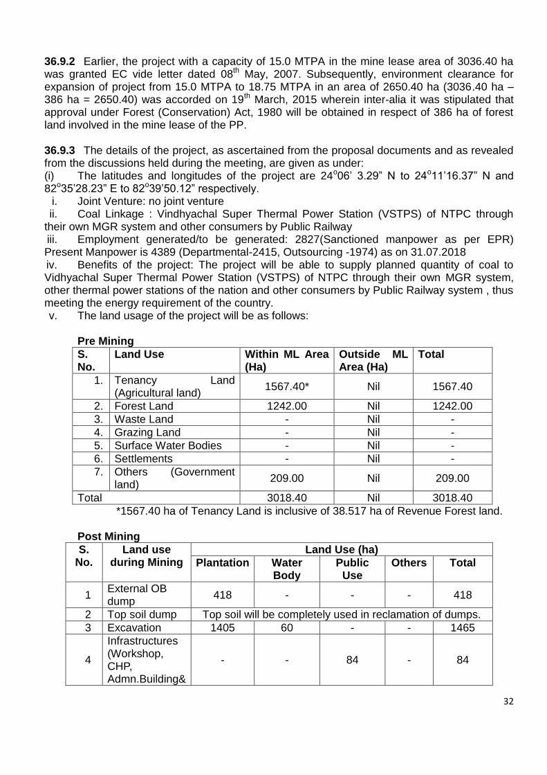
32
36.9.2 Earlier, the project with a capacity of 15.0 MTPA in the mine lease area of 3036.40 ha was granted EC vide letter dated 08th May, 2007. Subsequently, environment clearance for expansion of project from 15.0 MTPA to 18.75 MTPA in an area of 2650.40 ha (3036.40 ha – 386 ha = 2650.40) was accorded on 19th March, 2015 wherein inter-alia it was stipulated that approval under Forest (Conservation) Act, 1980 will be obtained in respect of 386 ha of forest land involved in the mine lease of the PP. 36.9.3 The details of the project, as ascertained from the proposal documents and as revealed from the discussions held during the meeting, are given as under: (i) The latitudes and longitudes of the project are 24o06’ 3.29” N to 24o11’16.37” N and 82o35’28.23” E to 82o39’50.12” respectively.
i. Joint Venture: no joint venture ii. Coal Linkage : Vindhyachal Super Thermal Power Station (VSTPS) of NTPC through
their own MGR system and other consumers by Public Railway iii. Employment generated/to be generated: 2827(Sanctioned manpower as per EPR) Present Manpower is 4389 (Departmental-2415, Outsourcing -1974) as on 31.07.2018 iv. Benefits of the project: The project will be able to supply planned quantity of coal to Vidhyachal Super Thermal Power Station (VSTPS) of NTPC through their own MGR system, other thermal power stations of the nation and other consumers by Public Railway system , thus meeting the energy requirement of the country. v. The land usage of the project will be as follows:
Pre Mining
S. No.
Land Use Within ML Area (Ha)
Outside ML Area (Ha)
Total
1. Tenancy Land (Agricultural land)
1567.40* Nil 1567.40
2. Forest Land 1242.00 Nil 1242.00
3. Waste Land - Nil -
4. Grazing Land - Nil -
5. Surface Water Bodies - Nil -
6. Settlements - Nil -
7. Others (Government land)
209.00 Nil 209.00
Total 3018.40 Nil 3018.40
*1567.40 ha of Tenancy Land is inclusive of 38.517 ha of Revenue Forest land. Post Mining
S. No.
Land use during Mining
Land Use (ha)
Plantation Water Body
Public Use
Others Total
1 External OB dump
418 - - - 418
2 Top soil dump Top soil will be completely used in reclamation of dumps.
3 Excavation 1405 60 - - 1465
4
Infrastructures (Workshop, CHP, Admn.Building&
- - 84 - 84

33
Roads)
5 Residential & Greenbelt
335 - 265 - 600
6
Undisturbed area (Forest land in Safety Zone)
147 - - 304.40 451.40
Total 2305 60 349 304.40 3018.40
vi. The total geological reserve is 561.71 MT. The mineable reserve 483.01 MT, extractable reserve is 483.01 MT (figures as on 31.03.2018). The per cent of extraction would be 85.99%. vii. The average product mix coal grade of all the seams is G-10. The stripping ratio is 3.90Cum/tonne. The average Gradient is 2° to 3°. There will be 03 seams with thickness
Coal Seam Thickness
From To
Purewa Top 4.00 10.94
Purewa Bottom 8.80 14.70
Turra 11.08 19.20
viii. The total estimated water requirement is 11440 cum/day. The level of ground water ranges from 2.70 m to 22.37 m below ground level, (As on May’ 2018) ix. The method of mining would be combined system of mining deploying dragline and shovel-dumper. x. There are 2 external OB dump with quantity of 231.00Mcum in an area of 418 Ha with
height of 150 meter above the surface level and 4 internal dump with Quantity of 1545.65Mcum in an area of 1405.00 Ha. xi. The final mine void would be in 60 Ha with depth varying from 30 to 40 m. and the total quarry area is 1465.00 Ha. Backfilled quarry area of 1405.00 Ha shall be reclaimed with plantation. xii. The life of mine is 14 years(Balance life as on 1.04.2018). xiii. Transportation: Coal transportation in pit: from mine pit to crusher by rear dumpers/tippers, Surface to Siding: By belt conveyors through CHP and through tippers alsoand siding to loading point: By Automatic loading system through Silo.
xiv. There is no R & R involved. xv. Cost: Total capital cost of the project is Rs. 2197.31 cr. (as per RCE 2015). CSR Cost Rs. 2/- per tonne of coal production. Environmental Management Cost Rs. 44.92 Cr (as per EPR).
xvi. Approvals:
Date of approval of Mining Plan from NCL Board on 21.06.2018 communicated vide letter no NCL/Board/229(C-2)/18/353dtd26.6.2018
Date of approval of Mine closure plan-integral part of Mining plan, approved on dt21.06.2018 by NCL Board.
xvii. Wildlife issues: There are no national Parks, wildlife sanctuary, biosphere reserves found in the 10 km buffer zone.
xviii. Total forest area involved is 1242.00 ha forest and 38.517 Ha Revenue forest. Forest Clearance has been obtained for the same. Final Approval/ Stage-II Forest clearance have

34
been granted for entire forest area i.e., 1260 Ha and 38.517 Ha Revenue forestof Nigahi Project, details of which are as follows:
Area (Ha)
Stage-II FC issued vide letter no. & date
874.00 8-62/86-FC dt. 18.06.1987 Forest land
386.00**
F.No. 8-26/2015-FC, dated 12.04.2018
Forest land 38.517**
Revenue Forest land
*18 Ha Forest land carved out for adjacent mine Jayant OCP. ** FC was granted for 424.517 Ha, out of which 38.517 Ha land was revenue forest land.
xix. The Forest clearance (stage-II) has been granted for 386 Ha above forest land vide letter no. F.No. 8-26/2015-FC, dated 12.04.2018. In addition to this, forest clearance for 38.517 ha of revenue forest (included within 1567.40 ha of tenancy land) has also been accorded. Thus, the total Forestry clearance of 424.517 ha (386 Ha forest land + 38.517 ha of revenue forest land) land has been obtained by the PP. xx. Total afforestation plan shall be implemented covering an area of 2305 Ha at the end of mining. Density of tree plantation is 2500 nos. perHa .
xxi. There is no court case/violation pending with the project proponent. xxii. The public hearing was held on 18th December, 2005 for 15 MTPA capacity. The issues raised during the public hearing included Rehabilitation & employment of oustees, social & economical problem of oustees and affected population like availability of drinking water, electricity and employment.
xxiii. The calendar programme of coal production proposed in Mining Plan :
Years Coal (Mt)
Yr-1 2018-19 18.75
Yr-2 2019-20 18.75
Yr-3 2020-21 18.75
Yr-4 2021-22 18.75
Yr-5 2022-23 18.75
Yr-6 2023-24 18.75
Yr-7 2024-25 18.75
Yr-8 2025-26 18.75
Yr-9 2026-27 18.75
Yr-10 2027-28 18.75
Yr-11 2028-29 18.75
Yr-12 2029-30 18.75
Yr-13 2030-31 12.00
Yr-14 2031-32 5.55
Total 242.55
xxiv. The certified compliance report submitted by the Regional Office, Bhopal vide their letter dated 23rd September, 2013 and the action taken report submitted by the PP on the observation of the Regional Office was considered by the EAC meeting held on 23-25th July, 2014 for grant of EC of 18.75 MTPA to the project. Fresh inspection report of the Regional Office on the updated status of compliance of conditions stipulated in the environment

35
clearance dated 8th May, 2007 read with amendment dated 19th March, 2015 has not been submitted by the PP. xxv. Nigahi OCP is catering to most of the Critical and Super Critical Thermal Power Plants and currently, production level achieved from the mine during the year 2017-18 was 17.13 MTPA. The PP mentioned that mine is under non-producing state for the want of EC for total lease area and accordingly, requested to grant environment clearance for the entire lease area.
36.9.4 During deliberations on the proposal, the EAC noted the following:- The proposal is for amendment in environment clearance dated 19th March, 2015 granted by the Ministry to the project for expansion of Nigahi Opencast Coal mine from 15 to 18.75 MTPA of M/s Northern Coalfields Limited in mine lease area of 2650.40 ha, excluding forest land of 386 ha having no stage-I forest clearance from the total area of 3036.40 ha, located in District Singrauli (Madhya Pradesh). Meanwhile, during reassessment/compilation of land records, an area of 38.517 ha of the total project area, earlier identified as tenancy land, was turned out to be the reserve forest land and thus requiring its diversion for non-forestry purposes. Stage-2 forest clearance has since been obtained vide letter dated 12th April, 2018 for diversion of (386+38.517) = 424.517 ha of forest land to non-forestry purposes. It is also proposed to carve out 18 ha of the forest land from the Nigahi OCP and to merge the same with the adjoining Jayant OCP for its expansion from 15.5 to 25 MTPA. Accordingly, revised land use for the Nigahi OCP would be as under:-
Land use Area (ha)
Forest land (as per the EC) 1242
Revenue forest land (earlier identified as tenancy land)
38.517
Government land 209
Tenancy land 1528.883
Total 3018.40
The amendment in environmental clearance has been sought in respect of mine lease area of Nigahi OCP to be revised from 2650.40 ha to (2650.40+386-18) i.e. 3018.40 ha. Mining Plan for the Nigahi OCP including the progressive Mine Closure Plan has also been revised accordingly and approved by the M/s NCL Board on 21st June 2018. 36.9.5 The EAC, after detailed deliberations, recommended for amendment in environmental clearance dated 19th March, 2015 for Nigahi Opencast Coal Mining Project of 18.75 MTPA, to revise the mine lease area from 2650.40 ha to 3018.40 ha with the land use break up as under-
Land use Area (ha)
Forest land (including revenue forest land of 38.517 ha)
1280.517
Government land 209
Tenancy land 1528.883
Total 3018.40

36
Agenda No.36.10 Bharatpur Opencast (Expansion) Coal Mine Project of 20 MTPA capacity of in mine lease area of 1386.20 ha of M/s Mahanadi Coalfields Limited (MCL), located in Tehsil Talcher, District Angul (Odisha) - For EC Amendment 36.10.1 The proposal is for amendment in environmental clearance dated 31st October, 2008 accorded for the expansion of Bharatpur OC project from 15 MTPA to 20 MTPA of M/s Mahanadi Coalfields Limited, located in Talcher Coalfields, Tehsil Talcher, District Angul (Odisha). Now the PP has applied for amendment in EC on account of change in total mine lease area. An area of 123.21 ha has been carved out from the Bharatpur mine lease and included in Jagannath OCP for the expansion of later mine from 6.0 MTPA to 7.5 MTPA, thereby reducing the area of Bharatpur OC to 927.42 ha. The proposal for expansion of Jagannath OC was considered and recommended for environment clearance by the EAC in its meeting held on 24th July 2018. 36.10.2 Facts of the proposal, as ascertained from the proposal documents and as revealed from the discussions held during the meeting, are given as under: (i) The area is bounded by the geographical coordinates of 20o56’35” and 20o58’40” N & 85o06’30” and 85o08’40” E. (ii) No joint venture cartel has been formed to operate the mine. Bharatpur OC Expansion Mine Project is being operated solely by the M/s MCL. (iii) Project does not fall in the Critically Polluted Area (CPA), where the MoEF&CC’s vide its OM dated 13th January, 2010 has imposed moratorium on grant of environment clearance. (iv) Coal linkage of Bharatpuir OC mine mainly lies with NALCO CPP & Other power houses. It is also reported that 5 MT of coal will be supplied to NALCO by closed conveyor belt. In addition to this coal will also be sold through basket linkages. (v) With regards to employment generation, it is mentioned that existing manpower engaged in the project is 1617. No additional manpower is reported to be required for the project. (vi) Benefits reported to be generated from the project include (a) improvement in physical and social infrastructure like roads, school building, provision of drinking water supply, community hall, raising of plantation etc.; (b) increase in employment potential; (c) contribution to the exchequer (both State and Central Govt.); (d) improvement of electrical supply regimes in rural areas; and (e) overall economic growth of the country by meeting the energy needs of the country. (vii) As per Mining Plan, total proposed lease area is 927.42 ha. Detail of land use plan, as made available by the PP is given as under:
Pre-Mining: (Area in ha)
S. No. Nature of land Within ML Outside ML Total
1. Agricultural 61.50 -- 61.50
2. Forest 155.37 -- 155.37
3. Waste land 369.85 -- 369.85
4. Grazing 0.00 -- 0.00
5. Surface water bodies 2.40 -- 2.40
6. Others 338.30 -- 338.30
Total 927.42 0.00 927.42
Pre-Mining purpose wise:
(Area in ha)

37
S. No.
Particulars Forest Govt. & Tenancy land
Total
1. Quarry excavation 138.76 561.87 700.63
2. Safety Zone (7.5m) 0.27 7.16 7.43
3. OB dump (external) 0.00 49.50 49.50
4. Infrastructure & Adjoining area 16.34 127.52 143.86
5. Rationalization of project boundary
0.00 26.00 26.00
Mining Lease Area Sub Total (A) 155.37 772.05 927.42
6. Residential colony 0.00 20.00 20.00
7. Rehabilitation site 0.00 41.40 41.40
Sub-total (B) 0.00 61.40 61.40
Total Land Requirement (A+B) 155.37 833.45 988.82
Post- Mining:
(Area in ha)
S. No.
Category Plantation Water body
Dip side slope &
haul road
Un-disturbed
Built-up
area
Total
1. Excavation 503.99 62.43 134.21 -- -- 700.63
2. Safety zone/ barrier(7.5m)
7.43 -- -- --- -- 7.43
3. OB dump (external) 49.50 -- -- -- -- 49.50
4. Infrastructure & adjoining area
28.77 -- -- -- 115.09 143.86
5. Rationalization of project boundary
3.06 1.75 -- 21.19 -- 26.00
6. Residential colony 2.00 -- -- -- 18.00 20.00
7. Rehabilitation site 4.40 -- -- -- 37.00 41.40
Total 599.15 64.18 134.21 21.19 170.09 988.82
(viii) Bharatpur OC involves 155.378 ha of forest land. Approval under the Forest (Conservation) Act, 1980 has been obtained by the PP on 2nd April, 1997 (71.64 ha) and on 7th February, 2014 (134.41 ha). Total area for which approval under the FC Act obtained by the PP is 206.05 ha against the 155.378 ha of forest land reported to be involved in the lease. (ix) Total geological reserve reported in the mine lease area is 400.37 MT with mineable/extractable reserve of 113.47 MT. (x) Number of workable seams reported in the mine is 6 with thickness of ranging from 4.29 m – 46.90 m. Seam-II is reported with the maximum thickness. Grade of coal is G-13, stripping ratio is 1:0.85 and average gradient is 40 to 50. (xi) Method of mining is opencast using shovel-dumper/ripper-dozer in OB/ parting; surface miner, pay loader and tipper in coal. (xii) Life of the mine has been reported to be 6 years. (xiii) The expansion project does not have external dumps for the storage of OB. However, there are 5 existing external dumps in an area of 49.50 ha with height of 30 m containing 9.92 Mm3 of OB. An area of 345.06 ha has been earmarked for internal dumping for storage of 259.56 Mm3 of OB (Post-mining).
38
(xiv) Total quarry area proposed is 700.63 ha and void will be created over an area of 64.18 ha with maximum depth of 165 m. An area of 503.99 ha will be backfilled and reclaimed with plantation. The final mine will be converted into water body. (xv) Afforestation Plan, at the end of mining, has been proposed to be implemented in an area of 599.15 ha with plantation of 2500 saplings per ha. Development of green belt has been proposed in 7.43 ha. (xvi) Transportation of coal in mine pit head has been proposed by tippers, surface to sidings by dumpers/tippers and at siding by Pay loaders. (xvii) Mining Plan, including the Mine Closure Plan, has been approved by the Board of MCL on 24th May, 2018 and the same was conveyed to the PP on 10th June, 2018. (xviii) Availability of ground water has been reported to be varying between 1.02 m – 13.07 m. Total water requirement for the project has been reported to be 6,777 KLD. (xix) The seasonal tributaries of Bangaru jhar are adjacent to the mine boundary. Brahmani river is located in east at 10.50 km from the mine boundary. Nandira jhar flows at 5.60 km in south from the mine boundary. Singada jhar flows at a distance of 6.30 km in north west from mine boundary. Bhalutungri stream flows at a distance of 8.80 km in north west from mine boundary. (xx) Proposal does not involve additional R&R. (xxi) Total cost of the project is Rs. 434.25 crores, CSR cost will be estimated based on 2% of the average net profit of the company for the three immediate preceding financial years or Rs. 2.00 per tonne of coal production of the previous year whichever is higher. R&R cost is 88.63 lakh. Cost incurred on environment Management till 1st April, 2018 is 2,66,14,160/-. (xxii) Process for obtaining approval of the Central Ground Water Authority is under progress. Updated status of the same has not been provided by the PP. (xxiii) No National Parks, Wildlife Sanctuaries, Biosphere Reserves have been reported within 10 km buffer zone of the mine lease. (xxiv) Public Hearing was conducted on 15th January, 2007 for 20 MTPA for mine lease area of 1324.80 ha. (xxv) Demand notice was issued by the Dy. Director Mines (I/c), Talcher Circle to pay compensation for production beyond the EC for the period between 2000-01 to 2010-11. No excess production after obtaining EC for 15 MTPA. (xxvi) Regional Office (Eastern Zone), of MoEF&CC at Bhubaneswar inspected the site on 26th June, 2018 to assess the status of compliance of conditions stipulated in the environment clearance dated 31st October, 2008. Certified compliance report was submitted by the Regional Office, vide letter no. 101-513/EPE/163 dated 6th July, 2018. The Regional Office reported partial compliance of certain conditions and also reported minor violation instructing the PP to take corrective measures. The Regional Office also sought an action plan from the PP to address observation reported in the inspection report. (xxvii) The PP has submitted the action plan on the observations of the Regional Office. The same is re-produced as under:
S. No. Observations of the Regional Office
Updated status of compliance
1 As per the record it has been found that PAs are not timely submitted the six monthly compliance reports to Regional Office
The half yearly compliance reports have regularly been submitted to the Regional office, Bhubaneswar. Earlier, it was thought that the compliance report is to be submitted before 30th June and 31st December for the period October to March and April to September of each year respectively.

39
Henceforth, the compliance report will be submitted within the stipulated time.
2 As per the submitted third party analysis reports of the ambient air quality. It has been found that the values of PM10 and SPM in various locations were found above the prescribed limit. It is requested to take suitable action for it’s controlling on all noticeable monitoring sites and action taken report be submitted to Regional Office
There were few instances of exceeding the prescribed limit of the values of PM10 and SPM.
The frequency of sprinkling has already been increased as immediate control measure.
The Ambient air quality monitoring for the month of April, May, June &July’2018 depicts that all the parameters are well maintained within the prescribed limit. The maximum values of Fortnightly monitored values in the month of April’18 is provided as bleow.
Locations SPM PM10
(µg/m3)
Nakeipasi village/N-W of the Mine 118 57
Near ETP 333 182
Civil maintenance office 227 129
Regional Store 249 308
Near view point 239 227
Balaram project office 539 209
However, the root cause analysis is being done for the monitoring sites where the values are exceeding and the appropriate actions including enhancing the frequency of sprinkling will be taken and the same will be submitted to the Regional Office,Bhubaneswar.
SILO with 15 MTPA capacity is going to be commissioned very soon in the project for dust free transportation of coal.
With commissioning of new SILO, the air quality parameters especially PM10 and SPM will certainly be maintained within the prescribed norms
3 As per the submitted third party analysis reports of heavy metals in ambient air results depicted that the values Hg were found significantly high in comparison to project office site area and near view point area in comparison to other sites. However, the values of Ni and Pb were observed in noticeable quantity in project site area and near viewpoint area in comparison to other sites. It is required to explore
Project office site area and near viewpoint area falls under core zone of Mine lease of adjacent mines namely Balaram OCP and Jagannath OCP respectively.
The project office site is adjacent to coal corridor (coal transportation road) and the viewpoint site is very near to active mine face.
The average monitoring values were derived from single sampling (24 hours average) analysis only.
The analysis of air sampling at these sites will be done again for confirmation for presence of these heavy metals and necessary directions in this regard already given to CMPDIL.
The reason for presence of Hg, Pb and Ni at

40
the reason of availability of Hg, Pb and Ni in specific monitoring sites.
these sites is being explored in detail and the same will be communicated Regional Office, Bhubaneswar by October’2018.
4 It has been found that majority of workers including officers are not wearing personal protective equipment (PPEs) during visit. It is requested to take suitable action on priority basis.
Personal protective equipment’s (PPEs) like safety shoes, safety helmets, nose masks, safety jackets etc. have already been provided to all the workers and officers.
Necessary actions and instructions, notices are being issued to comply the safety protocol including wearing personal protective equipment’s (PPEs) in the mine.
Awareness and sensitization regarding wearing personal protective equipment is being regularly discussed in the safety meetings.
This is taken into considered on utmost priority and hence forth, it will be followed dedicatedly in the mine.
5 As per MoEFF&CC circular No. J-2012/1/2006-IA.II(M) dated 27.05.2009 frequency of monitoring will be conducted on 15 days frequency (>0.1 MTPA), however, it has been noticed that PAs have conducted the monitoring of the various parameters on monthly basis. It is requested to conduct on 15 days basis
The Ambient Air Quality monitoring is being conducted on fortnightly basis for all the monitoring stations.
The effluent quality monitoring is also being conducted on fortnightly basis for all the monitoring points stipulated in the environmental statutes.
However, the frequency of monitoring will be as per the guidelines of the aforesaid circular.
6 It has been found that management of OB dumps including retaining wall, toe wall, catch drains, height of OB dump and its slope, plantation (including density), etc. is not up to the mark. Therefore, time bound action shall be prepared and executed with utmost dedication.
The external OB dumps are very old and stabilized.
The catch drains, garland drains and toe walls are already provided at appropriate locations of OB dumps and the drainage pattern is sloped towards the mine sumps to collect the surface runoff into the sumps.
The overall height of dumps is 30 m (maximum) and slope is maintained within the angle of repose
Preparation of time bound plan in detail for maintenance of management of OB dumps including retaining wall, toe wall, catch drains, height of OB dump is decided and maintenance work will be carried out after monsoon.
The Plantation is being done through state forest department.
The density of plants for biological reclamation in the OB backfilled area is 2500 nos. of plants

41
per hectare and 30 percent out of total the plantation covers the fruit bearing plants.
7 It has been noticed that 5.695 ha (56,925 sqm.) ML is being used for common coal corridor of 3.795 km, which is under construction, which is not being mentioned in the approved mining plan. As stated by PAs that above dedicated coal corridor road has been constructed as per OSPCB recommendation under the Critically Environmental Pollution Index (CEPI). It is requested to submit relevant documents to the Regional Office
Dedicated coal corridor road (3.79km) has been constructed as per directions and recommendation of OSPCB under the Critically Environmental Pollution Index (CEPI) for transportation of coal by avoiding the populated areas and villages.
The relevant document regarding the dedicated coal corridor road and CEPI report of OSPCB in which construction of dedicated coal corridor envisaged is already submitted to RO, MoEF&CC, Bhubaneswar.
36.10.3 During deliberations on the proposal, the EAC noted the following:-
The proposal is for amendment in environment clearance dated 31st October, 2008 granted by the Ministry to the project for expansion of Bharatpur Opencast Coal mine from 15 to 20 MTPA of M/s Mahanadi Coalfields Limited in mine lease area of 1324.80 ha (included 185.08 ha of forest and 1139.72 ha of non-forest land) located at tehsil Talcher, District Angul (Odisha). After reconciliation of land records, forest area has now increased by 32.78 ha within the said mine lease area of 1324.80 ha.
Amendment in environmental clearance has been sought for reduction in mine lease area from 1324.80 ha to 927.42 ha (includes forest area of 155.37 ha), mainly due to carving out of 123.21 ha and merging the same with the adjoining Jagannath OCP for its expansion project from 6 to 7.5 MTPA. Mining Plan for the Bharatpur OCP including the progressive Mine Closure Plan, has been revised accordingly and approved by the M/s MCL Board on 10th June 2018.
Earlier also, out of the mine lease area of 1324.80 ha of Bharatpur OCP, 114.48 ha of land was transferred to Jagannath OCP, 62.14 ha to Annanta OCP. However, no amendment has since been carried in the respective ECs at any stage. Further, forest land of 11.55 ha for which stage-I forest clearance was not available and the associated non-forest land of 86 ha has also been excluded from the presently envisaged Mining Plan of Bharatpur OCP. 36.10.4 The EAC, after deliberations, observed that no amendment in the ECs was earlier sought either for Bharatpur OCP or for Jagannath and Ananta OCPs, and mining operations were continued which actually amounts to non-compliance of the conditions stipulated therein. That also reflects overlapping of land areas involved under the said coal mining projects, simultaneously figuring in the respective ECs. The Committee insisted for a detailed clarification in this regard, and desired that the Ministry may take a view in complete perspective. The proposal was, therefore, not taken forward due to the anomalies stated above.

42
Agenda No.36.11 Cluster No.12 comprising of 15 mines of production capacity 31.83 MTPA (peak) in combined ML area of 12736 ha of M/s Eastern Coalfields Limited, located in Tehsil Haripur Block, District Burdwan (West Bengal) - For Amendment in EC
36.11.1 The proposal is for amendment in environment clearance granted by the Ministry vide letter dated 9th February, 2015 followed by amendment dated 3rd March, 2016, in favour of M/s Eastern Coalfields Limited for Cluster No.12 Coal Mining project (comprising of 15 mixed mines) of production capacity 31.83 (peak) in mine lease area of 12736 ha located in Tehsil Haripur Block, District Burdwan (West Bengal).
36.11.2 Earlier, amendment in environment clearance dated 9th February, 2015 was made and communicated to the project proponent vide letter dated 3rd March, 2016, on account of reorganisation of mines resulting in number of mines reduced from 19 to 15 and the combined mine lease area from 14047 ha to 12736 ha without any change in the production capacity.
36.11.3 Now further amendment has been sought in the earlier amendment dated 3rd March, 2016 in respect of the specific condition stipulated therein, reads as under:
‘the silo loading facility at Jhanjra should be completed within three years, and the production from Jhanjra should be enhanced to 5.0 MTPA only after commissioning both of the new railway siding, and the silo loading facilities.’
It has been informed that commissioning of the new railway siding is in the process and likely to be completed by December, 2020. Silo loading facility will be installed after commissioning of the new railway siding at Jhanjra, which would take another three years. Commissioning of new railway siding is delayed due to land acquisition problems. It is further mentioned by the PP that production from Jhajra UG project is likely to exceed from 3.50 MTPA during current financial year of 2018-19. In view of this, the PP has requested to permit them to produce 4.0 MTPA with the existing transport and loading system. ECL is committed to maintain environmental parameters within permissible limits by taking additional dust control measures.
36.11.4 During deliberations, the EAC noted that the proposal for construction of railway siding was still in the initial stages as only work order for preparation of DPR was issued on 22nd December, 2017. Further, no acquisition of land was done and as such, no satisfactory progress was observed.
36.11.5 The Committee, after deliberations and especially in view of no forest clearance available for 38.44 ha of forest land involved under one of the constituent mines namely, Tilaboni UG, did not agree to the proposed amendment in the environmental clearance dated 9th February, 2015, amended on 3rd March, 2016.
The Committee also desired for some substantial progress be made towards construction of railway siding to consider increase in production capacity of Jhanjra UG, and to amend the environment clearance accordingly. Agenda No.36.12
Chotia-I captive coal mining project (0.75 MTPA Opencast Cum Underground) in an ML area of 863 ha of M/s Bharat Aluminium Company Limited, located in villages Choita and Baniya, Tehsil Podiuprodha, District Korba (Chhattisgarh) - For EC revalidation

43
36.12.1 The proposal is for revalidation of environmental clearance dated 10th November, 2005 accorded to Chotia-I Captive Coal Mining Project of 0.75 MTPA capacity in mine lease area of 863 ha of M/s Bharat Aluminium Company Limited located in villages Chotia and Baniya, Tehsil Podiuprodha, District Korba (Chhattisgarh). 36.12.2 Facts of the proposal, as ascertained from the proposal documents and as revealed from the discussions held during the meeting, are given as under: (i) Detail of geographical coordinates of the mine is given as under:
CHOTIA-I Coordinates CHOTIA-I Coordinates
SN
NAME NORTHING EASTING SN NAME NORTHING
EASTING
1 BP-1 22° 46' 56.9" N 82° 29' 01.3" E
20 BP-1U 22° 47' 48.6" N
82° 26' 52.8" E
2 BP-1A 22° 47' 0.8" N 82° 28' 37.7" E
21 BP-2U 22° 47' 51.3" N
82° 26' 55.8" E
3 BP-2 22° 47' 4.5" N 82° 28' 35.8" E
22 BP-3U 22° 47' 50.9" N
82° 27' 4.0" E
4 BP-2A 22° 47' 7.8" N 82° 28' 25.2" E
23 BP-4U 22° 47' 45.1" N
82° 27' 3.6" E
5 BP-3 22° 47' 2.5" N 82° 28' 14.0" E
24 BP-5U 22° 47' 44.6" N
82° 26' 56.5" E
6 BP-3A 22° 47' 5.9" N 82° 28' 04.7" E
25 BP-6A 22° 47' 40.2" N
82° 26' 59.3" E
7 BP-3B 22° 47' 7.5" N 82° 28' 04.4" E
26 BP-6B 22° 47' 31.1" N
82° 27' 7.7" E
8 BP-3C 22° 47' 8.8" N 82° 27' 59.3" E
27 BP-6C 22° 47' 06.3" N
82° 27' 42.0" E
9 BP-3D 22° 47' 10.1" N 82° 27' 58.6" E
28 BP-6D 22° 47' 13.6" N
82° 27' 44.7" E
10 BP-5A 22° 47' 09.0" N 82° 27' 55.3" E
29 BP-6E 22° 47' 20.4" N
82° 27' 47.9" E
11 BP-4G 22° 47' 17.6" N 82° 27' 49.8" E
30 BP-7 22° 48' 21.5" N
82° 27' 10.3" E
12 BP-4F 22° 47' 04.7" N 82° 27' 44.5" E
31 BP-7A 22° 48' 40.5" N
82° 27' 53.4" E
13 BP-4E 22° 46' 55.9" N 82° 27' 56.7" E
32 BP-8 22° 48' 16.1" N
82° 28' 34.4" E
14 BP-4D 22° 46' 55.7" N 82° 27' 06.3" E
33 BP-9 22° 48' 02.3" N
82° 28' 29.1" E
15 BP-10A 22° 47' 28.8" N 82° 26' 18.0" E
34 1 22° 46' 55.4" N
82° 28' 29.5" E
16 BP-10 22° 47' 53.0" N 82° 28' 46.6" E
35 2 22° 46' 55.4" N
82° 28' 37.4" E
17 BP-11A 22° 48' 03.3" N 82° 26' 16.2" E
36 3 22° 47' 03.0" N
82° 28' 35.9" E
18 BP-11 22° 47' 23.4" N 82° 29' 09.6" E
37 4 22° 47' 5.19" N
82° 28' 22.7" E
19 BP-12 22° 48' 04.0" N 82° 26' 38 5 22° 47' 82° 28' 24.4"
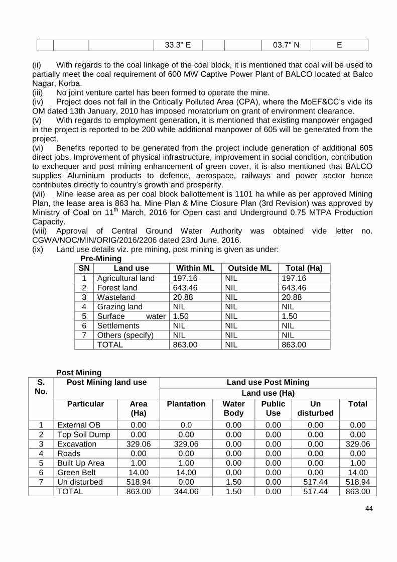
44
33.3" E 03.7" N E
(ii) With regards to the coal linkage of the coal block, it is mentioned that coal will be used to partially meet the coal requirement of 600 MW Captive Power Plant of BALCO located at Balco Nagar, Korba. (iii) No joint venture cartel has been formed to operate the mine. (iv) Project does not fall in the Critically Polluted Area (CPA), where the MoEF&CC’s vide its OM dated 13th January, 2010 has imposed moratorium on grant of environment clearance. (v) With regards to employment generation, it is mentioned that existing manpower engaged in the project is reported to be 200 while additional manpower of 605 will be generated from the project. (vi) Benefits reported to be generated from the project include generation of additional 605 direct jobs, Improvement of physical infrastructure, improvement in social condition, contribution to exchequer and post mining enhancement of green cover, it is also mentioned that BALCO supplies Aluminium products to defence, aerospace, railways and power sector hence contributes directly to country’s growth and prosperity. (vii) Mine lease area as per coal block ballottement is 1101 ha while as per approved Mining Plan, the lease area is 863 ha. Mine Plan & Mine Closure Plan (3rd Revision) was approved by Ministry of Coal on 11th March, 2016 for Open cast and Underground 0.75 MTPA Production Capacity. (viii) Approval of Central Ground Water Authority was obtained vide letter no. CGWA/NOC/MIN/ORIG/2016/2206 dated 23rd June, 2016. (ix) Land use details viz. pre mining, post mining is given as under:
Pre-Mining
SN Land use Within ML Area (ha)
Outside ML Area (ha)
Total (Ha)
1 Agricultural land 197.16 NIL 197.16
2 Forest land 643.46 NIL 643.46
3 Wasteland 20.88 NIL 20.88
4 Grazing land NIL NIL NIL
5 Surface water bodies
1.50 NIL 1.50
6 Settlements NIL NIL NIL
7 Others (specify) NIL NIL NIL
TOTAL 863.00 NIL 863.00
Post Mining
S. No.
Post Mining land use Land use Post Mining
Land use (Ha)
Particular Area (Ha)
Plantation Water Body
Public Use
Un disturbed
Total
1 External OB Dump
0.00 0.0 0.00 0.00 0.00 0.00
2 Top Soil Dump 0.00 0.00 0.00 0.00 0.00 0.00
3 Excavation 329.06 329.06 0.00 0.00 0.00 329.06
4 Roads 0.00 0.00 0.00 0.00 0.00 0.00
5 Built Up Area 1.00 1.00 0.00 0.00 0.00 1.00
6 Green Belt Area
14.00 14.00 0.00 0.00 0.00 14.00
7 Un disturbed Area
518.94 0.00 1.50 0.00 517.44 518.94
TOTAL 863.00 344.06 1.50 0.00 517.44 863.00
45
(x) Total forest area involved in the mining lease of the PP is 643.56 ha. Forest clearance under the Forest (Conservation) Act, 1980 has been obtained by the PP on 10th November, 2005 (181.50 ha), 4th January, 2011 (459.269 ha) and on 1st April, 2015 (2.691 ha). (xi) Total geological reserve reported in the mine lease area is 29.19 MT with 25.45 MT mineable reserve, out of which 9.81 MT of reserve is extractable reserve with extraction intensity of 38 %. (xii) Three workable seams with thickness ranging from 0.30 m to 5.18 m have been reported as workable. Grade of coal varies from G-4 to G-19, stripping ratio is 1:10 and average gradient is 30 to 60. Degree of gaseousness is 1. (xiii) Method of mining envisages opencast as well as underground. Open cast mining has been proposed to be operated with conventional shovel-dumper combination while UG mine will be operated by adopting Bord & Pillar method using SDL/LHD and Continuous Miner. (xiv) Transportation of coal in mine pit head has been proposed using 30 tonne. Detail pertaining to trasporation of coal from mine to Thermal Power Plant has not been provided by the PP. (xv) Life of mine has been reported to be 20 years. (xvi) No external and internal dumping is involved in the project. (xvii) Green belt will be developed in an area of 14.0 ha while additional undisturbed area of 518.94 ha has also been proposed to be developed as green belt area with saplings density of 2500 per ha. (xviii) Total quarry area is 329.06 ha which will be backfilled completely and will be reclaimed biologically by planting of seedlings. (xix) No National Parks, Wildlife Sanctuaries, Eco-sensive Zone are located within the 10 km of the project boundary. However, it is reported that wildlife fauna is present in study area and a Wildlife Management Plan, involving financial provisions of Rs. 4.43 crores has been prepared and the funds for the implementation of the same have been depsotied in to the account of Ad-hoc CAMPA. (xx) Regular monitoring of Ambient Air Quality is being carried out and submitted to Chhattisgarh Environment Conservation Board and also to MoEF&CC. All PM10, PM2.5, SO2 and NOX values are found to be well within prescribed limits of CPCB. (xxi) Hasdeo river is located at a distance of 7.3 km in east direction from the mine lease boundary of the PP. (xxii) Availability of ground water has been reported between 45.0 m – 50 m. Total estimated water requirement for the project is 600 cum/day, comprising of 250 Cum/day for mining purposes and 350 Cum/day for domestic purposes. (xxiii) The PP has reported no court cases, violation cases are pending against the project of the PP. (xxiv) The project does not involve project affected families. (xxv) Regular monitoring of Ambient Air Quality is being carried out and submitted to Chhattisgarh Environment Conservation Board and also to MoEF&CC. All PM10, PM2.5, SO2 and NOX values are found to be well within prescribed limits of CPCB. (xxvi) No capital cost is reported in view of the fact that the project is an existing project and all infrastructure is already in place. Cost of production has been reported to be Rs. 5,100/- per tonne. With regards to CSR, it is reported that responsibilities regarding CSR in terms of Section 135 (1) of the Companies Act are currently not applicable on BALCO since it is making losses for last three financial years. However, as a responsible corporate, BALCO continues to be committed to uplifting communities in its neighbourhood. As a part of this commitment, a social needs assessment was carried out in and around Chotia-II Coal Mine. Based on this assessment, a budget of Rs. 5/tonne of coal production is taken for Enterprise Social

46
Commitment (ESC). Environment Management Cost is Rs. 10 per tonne of coal. (xxvii) Public hearing was conducted on 6th January, 2018 at village-Bhujangkhachar, Tehsil- Podiuprodha, District-Korba. However, detail of issues raised during the public hearing and commitment made by the PP thereof, has not been provided by the PP.
36.12.3 Earlier, the proposal for grant of environmental clearance to Chotia-II Captive coal mining project of 1 MTPA of M/s Bharat Aluminium Company Limited in total mine lease area of 316.826 ha was considered by the EAC in its meeting held on 17-18 April, 2018, wherein the Committee insisted for single environmental clearance, both for Chotia-I & Chotia-II, against combined mining lease of 1179.826 ha and single Mining Plan. Further, in view of the Chotia-I remains an integral part of the combined mining lease area of 1179.826 ha, the Committee also desired monitoring report on compliance status of the conditions stipulated in the EC dated 10th November, 2005 issued in favour of M/s Prakash Industries Ltd, later transferred to M/s Bharat Aluminium Company Ltd on 4th June, 2015. 36.12.4 During deliberations on the proposal, the Committee noted the following:- Earlier, Chotia-I Captive Coal Mining project of capacity 0.75 MTPA (OC/UG) in mine lease area of 863 ha located in villages Chotia and Baniya, Tehsil Podiuprodha, District Korba (Chhattisgarh) was granted environmental clearance by the Ministry vide letter dated 10th November, 2005 in favour of M/s Prakash Industries Ltd. Subsequent to cancellation of coal blocks in the year 2014 as per the orders of Hon’ble Supreme Court, the said coal block was allotted to M/s Bharat Aluminium Company Limited (BALCO) by the Nominated Authority in the Ministry of Coal, and accordingly, the said EC was transferred in their name on 4th June, 2015. The present proposal is for regularization of the EC in terms of the Ministry’s Notification S.O.1530(E) dated 6th April, 2018. The EAC, while considering the proposal of Chotia-II captive coal mining project of 1 MTPA in its meeting held on 17-18 April, 2018, insisted for single environmental clearance, both for Chotia-I & Chotia-II, against combined mining lease of 1179.826 ha and single Mining Plan. Chotia-II captive coal mining project has been granted environmental clearance for a period of one year subject to that condition. 36.12.5 The EAC, after deliberations and especially in view of its earlier observations during the meeting held on 17-18 April, 2018, asked the project proponent to go for single ToR/EC both for Chotia-I & Chotia-II, against combined mining lease of 1179.826 ha and single Mining Plan. Another option could be one to one, both for Chotia-I & Chotia-II separately.
The proposal was, therefore, deferred for the needful on the above lines. Agenda No.36.13 Expansion of Tara (East) and Tara (West) Coal Mine Project from 2.0 MTPA to 4.0 MTPA peak rated capacity in an ML area of 937.44 ha of M/s West Bengal Power Development Corporation Limited located in Block Jamuria, Tehsil Jamuria, District Barddhaman (West Bengal) - For ToR 36.13.1 The proposal is for ToR for expansion of Tara (East) and Tara (West) Coal Mine Project from 2.0 MTPA to 4.0 MTPA peak rated capacity in an ML area of 937.44 ha of M/s
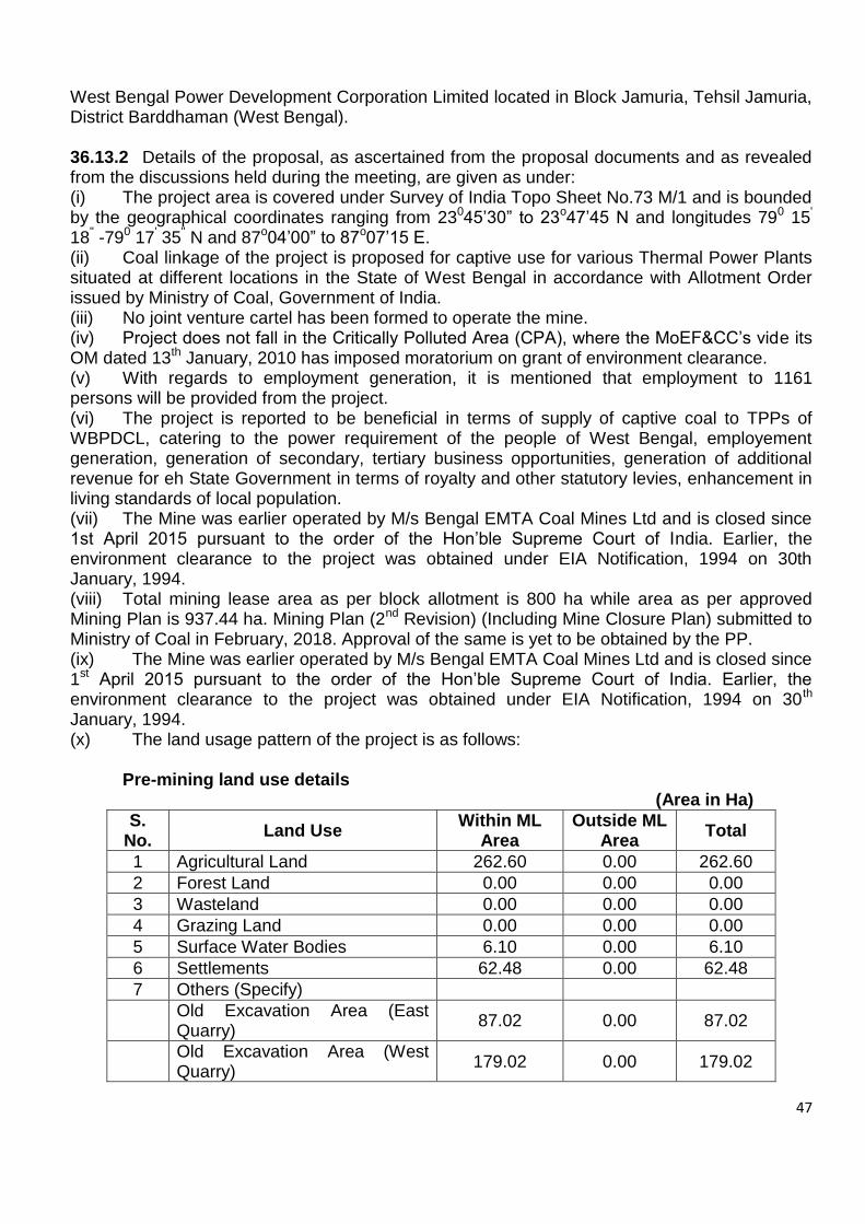
47
West Bengal Power Development Corporation Limited located in Block Jamuria, Tehsil Jamuria, District Barddhaman (West Bengal). 36.13.2 Details of the proposal, as ascertained from the proposal documents and as revealed from the discussions held during the meeting, are given as under: (i) The project area is covered under Survey of India Topo Sheet No.73 M/1 and is bounded by the geographical coordinates ranging from 23045’30” to 23o47’45 N and longitudes 790 15' 18" -790 17' 35" N and 87o04’00” to 87o07’15 E. (ii) Coal linkage of the project is proposed for captive use for various Thermal Power Plants situated at different locations in the State of West Bengal in accordance with Allotment Order issued by Ministry of Coal, Government of India. (iii) No joint venture cartel has been formed to operate the mine. (iv) Project does not fall in the Critically Polluted Area (CPA), where the MoEF&CC’s vide its OM dated 13th January, 2010 has imposed moratorium on grant of environment clearance. (v) With regards to employment generation, it is mentioned that employment to 1161 persons will be provided from the project. (vi) The project is reported to be beneficial in terms of supply of captive coal to TPPs of WBPDCL, catering to the power requirement of the people of West Bengal, employement generation, generation of secondary, tertiary business opportunities, generation of additional revenue for eh State Government in terms of royalty and other statutory levies, enhancement in living standards of local population. (vii) The Mine was earlier operated by M/s Bengal EMTA Coal Mines Ltd and is closed since 1st April 2015 pursuant to the order of the Hon’ble Supreme Court of India. Earlier, the environment clearance to the project was obtained under EIA Notification, 1994 on 30th January, 1994. (viii) Total mining lease area as per block allotment is 800 ha while area as per approved Mining Plan is 937.44 ha. Mining Plan (2nd Revision) (Including Mine Closure Plan) submitted to Ministry of Coal in February, 2018. Approval of the same is yet to be obtained by the PP. (ix) The Mine was earlier operated by M/s Bengal EMTA Coal Mines Ltd and is closed since 1st April 2015 pursuant to the order of the Hon’ble Supreme Court of India. Earlier, the environment clearance to the project was obtained under EIA Notification, 1994 on 30th January, 1994. (x) The land usage pattern of the project is as follows:
Pre-mining land use details
(Area in Ha)
S. No.
Land Use Within ML
Area Outside ML
Area Total
1 Agricultural Land 262.60 0.00 262.60
2 Forest Land 0.00 0.00 0.00
3 Wasteland 0.00 0.00 0.00
4 Grazing Land 0.00 0.00 0.00
5 Surface Water Bodies 6.10 0.00 6.10
6 Settlements 62.48 0.00 62.48
7 Others (Specify)
Old Excavation Area (East Quarry)
87.02 0.00 87.02
Old Excavation Area (West Quarry)
179.02 0.00 179.02

48
Old OB Dumps 0.00 96.21 96.21
Roads & Mine Infrastructure 0.00 21.27 21.27
R & R Colony 6.0 0.00 6.0
Staff Colony 0.00 10.0 10.0
Green Belt 0.00 9.96 9.96
Balance Area 196.78 0.00 196.78
Total Project Area = 800.00 137.44 937.44
WBPDCL has already applied for ML for additional 137.44 ha area. Thus, the entire 937.44 Ha area shall be under Mining Lease before start of the mining operations.
Post Mining
S. No.
Land use Land use (ha)
Plantation Water Body
Public Use
Undisturbed Total
1 External OB Dump
96.21 --- --- --- 96.21
2 Top Soil Dump --- --- --- --- ---
3 Excavation 350.03 55.03 --- --- 405.06
4 Roads --- --- 3.59 --- 3.59
5 Built-up Area --- --- 21.27 --- 21.27
6 Green Belt 9.96 --- --- --- 9.96
7 Undisturbed Area
--- --- --- 329.79 329.79
8 Safety Zone / Rationalization Area
50.58 --- --- --- 50.58
9 Diversion / Below River / Nala / Canal
--- 6.10 --- --- 6.10
10 Water Body --- 4.88 --- --- 4.88
11 Staff Colony --- --- 10.00 --- 10.00
Total Area = 506.78 66.01 34.86 329.79 937.44
(xi) Total geological reserve reported in the mine lease area is 209.69 MT (102.67 by OC and 107.02 MT by UG) with 71.61 MT mineable reserve. It is further mentioned that out of mineable reserve of 71.61 MT, 53.83 MT has already been depleted thus balance 17.78 MT are available for extraction. Percent of extraction is 69.7%. (xii) 11 seams with thickness ranging from 0.15 m – 11.69 m have been reported as workable. Grade of coal is G-8 to G-9, stripping ratio 1:10.72, while gradient is 120 to 150 . (xiii) Method of mining envisages operations by open cast methods (xiv) Life of mine has been reported to be 11 years. (xv) The project has 4 external OB dumps in an area of 96.21 ha with 60 m height and 34.0 Mm3 of OB. Existing OB Dumps shall be re-handled and backfilled in 12th, 13th and 14th year. The OB from the current mining operations shall be backfilled from 1st year onwards. One internal OB in an area of 350.03 ha with 190.560 Mm3 of OB is envisaged in the project. (xvi) Total quarry area is 405 ha out of which backfilling will be done in 350.03 ha while final mine void will be created in an area of 55.03 m with a depth of 30 m. Backfilled quarry area of 350.03 Ha shall be reclaimed with plantation. Final mine void will be converted into water body.
49
(xvii) Transportation of coal has been proposed by dumpers in mine pit head, from surface to siding by tippers and at sidings by Pay loaders (xviii) Reclamation plan in an area of 456.2 ha, comprising of 96.21 ha of External dump, 350.03 ha of internal dump and 9.96 ha of green belt. In addition to this an area of 50.58 ha, included in the safety zone/rationalization area, has also been proposed for green belt development. (xix) No forest land has been reported to be involved in the project. (xx) No National Parks, Wildlife Sanctuaries and Eco-Sensitive Zones have been reported with 10 km boundary of the project. (xxi) Ajay River is flowing close to the North-Eastern boundary of lease. One seasonal Nallah passing from Central part of the lease. (xxii) The PP has reported no court cases, violation cases are pending against the project of the PP. (xxiii) The project involves 455 project affected families. (xxiv) Total cost of the project is Rs. 33560 lakhs. Cost of production is Rs. 133/- per tonne. Det 87 per tonne, CSR cost is Rs. 2 per tonne, R&R cost is 79.79 crores. Environment Management Cost is Rs. 0.9709 crores.
36.13.3 During deliberations on the proposal, the Committee noted the following:-
The proposal is for ToR for Tara (East) & Tara (West) Coal Mine Project of capacity 4 MTPA (peak) of M/s West Bengal Power Development Corporation Limited in mine lease area of 937.44 ha located in Block Jamuria, District Paschim Bardhaman (West Bengal). Earlier, the Ministry had granted environment clearance vide letter dated 30th January, 1997, to Tara (East & West) Blocks Coal Mine project of capacity 2 MTPA in an area of 361 ha located at village Churulia, District Burdwan (West Bengal) in favour of M/s Bengal EMTA Coal Mines Ltd. Subsequent to cancellation of coal blocks in the year 2014 as per the orders of Hon’ble Supreme Court, the said coal block was allotted to M/s West Bengal Power Development Corporation Limited by the Nominated Authority in the Ministry of Coal. Accordingly, the said EC was transferred in their name on 6th July, 2015 subject to compliance of all the conditions stipulated in the earlier EC. There has been, however, no mining operations carried out by the present allottee and the mine is closed since 1st April, 2015. Actual coal production during the period 1999-00 to 2013-14 in mine lease of 800 ha is more than the approved EC capacity of 2 MTPA in mine lease area of 361 ha. Also, the actual coal production during the said period is much more than that Mining Plan originally approved in 1996 and/or revised Mining Plan approved in the year 2005. That, in fact, amounts to violation of the Mining Plan and non-compliance of the conditions stipulated in the EC. 36.13.4 The EAC, after deliberations, took serious note of the gross violation of the Mining Plan, and also non-compliance of the EC conditions by the earlier allottee. The Committee also noted that the Mining Plan has been revised again by the Ministry of Coal on 30th August, 2018 with the mine lease area now increased from 800 ha to 937.44 ha, without taking any cognizance of the earlier violation. The Committee desired to know whether the given status warrants any action by either of the regulatory authority. The proposal was, therefore, deferred for the needful on the above lines.

50
36.14 Discussion on any other item with permission of the chair The Committee discussed the general approach to be taken regarding proposals for revalidation of ECs granted under the EIA Notification, 1994, in terms of this Ministry’s Notification dated 6th April, 2018 for mining projects. The Committee decided that all such proposals must comply with the following:
Public notice to be issued in leading newspapers (one national and two local) through concerned SPCBs for information of the stakeholders about the project and present coal mining operations inviting comments and their redressal,
Valid Mining Plan and the Mine Closure Plan duly approved by the competent authority,
Compliance status of the conditions stipulated in the environmental from the concerned Regional Office of the Ministry.
Consent to operate from the State Pollution Control Board for the present mining operations.
Redressal of issues raised during the last public hearing conducted by the SPCB.
Coal production realized from the mine from 1994-95 vis-à-vis capacity stipulated in the environment clearance.
Details of court cases and the compliance status.
*****