mineral station area framework - littletongov.org
TRANSCRIPT

Approved by Littleton City Council on March 20, 2018
Mineral Station Area Framework

Mineral Station Area Framework
March 20, 2018
TABLE OF CONTENTS
HOW TO USE THE FRAMEWORK pg. 1
Chapter 1 - INTRODUCTION pg. 2 • Intent and Organization • Study Area • Community Engagement • Additional Planning Resources • Acknowledgements
Chapter 2 - PLANNING AND ENVIRONMENTAL LINKAGES STUDY (PEL) pg. 6
• South Santa Fe Drive Planning and Environmental Linkages Study • Implementation
Chapter 3 - EXISTING CONDITIONS pg. 10
• Mineral Light Rail Station • Extension of SW Light Rail Line • Description of Study Area • Market Assessment • Intersection of South Santa Fe and Mineral • Pedestrian and Bicycle Infrastructure • Existing Strengths and Challenges
Chapter 4 - TRANSPORTATION pg. 16
• Goals • Action Steps
Chapter 5 - RECREATION, OPEN SPACE, PARKS AND TRAILS pg. 19
• Goals • Action Steps
Chapter 6 - CHARACTER AND DESIGN pg. 21
• Goals • Action Steps
Chapter 7 - LAND USE pg. 24
• Goals • Action Steps

Mineral Station Area Framework
March 20, 2018
Figures • Figure 1: Study Area Aerial Map pg. 9 • Figure 2: Existing Transportation Map pg. 15 • Figure 3: Existing Open Space Map pg. 18 • Figure 4: Existing Land Use Map pg. 23
Appendices
• Appendix A: History of the Planning Process pg. 26 • Appendix B: Mineral Station Market Assessment, May 2016 pg. 30 • Appendix C: Mineral Light Rail Station 2016 Community
Engagement Overview pg. 49
Cover Photo: • Pedestrian / bicycle bridge across South Santa Fe Drive between the Mineral Station
Platform and the Park-n-Ride

Mineral Station Area Framework
Page 1 March 20, 2018
HOW TO USE THE FRAMEWORK
INTENT The purpose of the Mineral Station Framework (Framework) is as a foundational guide for the city’s efforts to improve South Santa Fe Drive (US 85) and the South Santa Fe Drive and Mineral Avenue intersection. The Framework will provide a foundation for a Planning and Environmental Linkages Study (PEL) that will identify options to address a broad range of existing and future transportation needs along the stretch of South Santa Fe Drive (US 85) corridor between I-25 and C-470.
In addition, the Framework serves as a foundation for future decision-making in the area of the city. Future decisions will build upon the Framework to strengthen the city’s sense of community, its livability, its fiscal health, and its sustainability.
LOCATION The study area for the Framework includes the Regional Transportation District’s (RTD’s) Mineral Light Rail Station property, including the platform and the Park-n-Ride bus transfer facility and parking lots. It extends to include the area within a one-half mile radius from the platform. Generally, the study area is bounded by the north end of Aspen Grove on the north, the South Platte River on the west, Dad Clark Gulch on the south and Prince Street on the east.
CHAPTERS
Chapter 1 of the Framework provides more detail about the intent and organization of the framework, the study area, the 2016 community engagement process, additional planning resources used in developing the Framework and that should be consulted for future decision-making. Chapter 2 of the Framework provides more information about the Planning and Environmental Linkages Study (PEL), including its intent and process. Chapter 3 provides an overview of existing conditions in the study area.
Chapters 4 – 7 outline goals and action steps on the categories of transportation; recreation, open space, parks and trails; character and design; and, land use. Chapter 4 covers transportation; Chapter 5 covers recreation, open space, parks and trails; Chapter 6 covers character and design; and Chapter 7 covers land use. Both the goals and the action steps are based on comments recorded during the 2016 community engagement process for the Mineral Station Area planning process.
APPENDICES AND MAPS
The Appendices include a detailed history of the planning process, a market assessment completed for the study area, and the 2016 and 2018 Mineral Light Rail Station area community engagement comments. Maps are provided to help identify the study area and the existing transportation facilities, recreation, open space, trails and land uses.

Mineral Station Area Framework
Page 2 March 20, 2018
Chapter1:
INTRODUCTION
INTENT AND ORGANIZATION The Mineral Station Framework is intended to provide direction for the city’s efforts to improve South Santa Fe Drive (US 85) and the South Santa Fe Drive and Mineral Avenue intersection, and will guide future planning and decision-making for this area of the city. Future decision-making in this area of the city has the potential to enhance the fiscal health and sustainability of the city and to continue to strengthen the city’s sense of community and its livability.
The term “framework” is used in recognition that the information contained in the document is a broad overview of current issues and topics, and can be adapted to change over time as those issues and topics evolve.
The framework is structured as a reference guide; each chapter conveys information on a particular category. These categories are interconnected, and the chapters, both individually and collectively, are important to consider in future decision-making. Specifically, the Framework:
• Outlines the intent and process of a City-initiated Planning and Environmental Linkages Study (PEL) for identifying and addressing issues and constraints along the South Santa Fe Drive corridor. This study will include issues and constraints concerning the intersection of Santa Fe and Mineral Avenue and those associated with transit, including parking.
• Identifies existing conditions (both assets and challenges) in this area of the city. • Articulates the community’s goals for the area, with actionable steps. Both the goals and the
action steps are based on comments recorded during the 2015-2016 community engagement process for the Mineral Station Area planning process. The goals and action steps sort themselves into four categories: 1 ) Transportation; 2 ) Recreation, Open Space, Parks and Trails; 3) Character and Design; and 4) Land Use.
STUDY AREA The framework’s study area includes the Mineral Station property, and also includes approximately one- half mile around the light rail station. The study area is bounded by the north end of Aspen Grove on the north, the South Platte River on the west, Dad Clark Gulch on the south and Prince Street on the east. Existing uses within the area include the light rail station, Park-n-Ride, parks, recreational trails, open space, well established residential neighborhoods, newer apartments, and the Aspen Grove shopping center. There also is an approximately 110-acre, mostly-undeveloped, private property south of Mineral Avenue between South Santa Fe Drive and South Platte Park, which was zoned in 1983 to allow a mixture of commercial and residential uses. The Framework also acknowledges the study area’s location within the larger context of the city and region.
The Regional Transportation District’s (RTD’s) Littleton Mineral Light Rail Station (Mineral Station) serves

Mineral Station Area Framework
Page 3 March 20, 2018
the C and D lines of Southwest Light Rail Corridor. The station opened in 2000 and is one of the busiest and most utilized stations within RTD’s system. Mineral Station is located on the northeast corner of the intersection of South Santa Fe Drive (US 85) and Mineral Avenue, which is one of the busiest vehicular intersections in Littleton. Additionally, the Mary Carter Greenway regional trail system and the main entrance to the South Platte Park’s Carson Nature Center are accessed by public streets through the station property.
COMMUNITY ENGAGEMENT In 2013, Littleton received a Federal Transit Administration (FTA) grant to use the principles of transit oriented development (TOD) to create master plans for the areas around its two light rail stations, the Littleton Downtown Station (Downtown Station) and the Littleton Mineral Avenue Station (Mineral Station). In 2015, the city hired the firm of Progressive Urban Management Associates (PUMA) to assist with these master planning projects.
The planning process for the Mineral Station area started first. Two main tasks were to be part of the project – undertake a market assessment of the Mineral Station study area, and vetting of the project and content of the master plan through a thorough community engagement process.
The community engagement process included a series of public open houses and meetings, including options for on-line community input, which were held between March and August, 2016. PUMA began a working document to form the basis for a Mineral Station Area Master Plan.
In November, 2016, Littleton’s Community Development staff presented to the city’s Planning Commission an overview of all of the community comments provided on the project. During this study session, planning commissioners reiterated that the content of the plan was to take its direction from community input. The main themes from community input were:
• Agreement that traffic and parking were major concerns. The primary concerns focused on traffic congestion radiating from the intersection of South Santa Fe Drive and Mineral Avenue and the shortage of parking at the Park-n-Ride at the Mineral Station. It was noted that, generally, the two parking lots at the Park-n-Ride are full by 7am each weekday.
• Agreement that access to recreation along the South Platte River and the Mary Carter Greenway and at South Platte Park and the Carson Nature Center is a unique and highly desirable community asset and that those resources and the community’s connections to them are of utmost importance to the community.
• Differences of opinions and ideas were vast regarding future land uses, building heights, and residential types and densities.
Public comments indicated it was difficult for community members to provide constructive input for future development and redevelopment within the station area without additional information and a clear understanding of projected traffic volumes, parking demands, and possible responses. The type of potential changes in transportation facilities that might affect future development and

Mineral Station Area Framework
Page 4 March 20, 2018
redevelopment of the station area include a possible expansion of the intersection of Mineral and South Santa Fe. In order to accommodate increased traffic volumes and to improve pedestrian and bicycle connections, an expansion or reconfiguration of the streets and of the intersection might require shifting South Santa Fe to the west and the pedestrian bridge to the north. Similarly, additional development to the south, in Douglas County, or, at some point in the future, an expansion of the Southwest light rail line south and east to Lucent Boulevard in Highlands Ranch, as part of the RTD FasTracks project, is anticipated to impact the traffic volumes and parking demand at the Mineral Station.
As these issues were further discussed, it became apparent that the creation of a master plan for the Mineral Station property would be premature. In response, the city engaged with the Colorado Department of Transportation (CDOT) and the cities of Englewood, Sheridan, and Denver to initiate a planning process for the South Santa Fe corridor. In December of 2017 Littleton City Council directed staff to use the 2016 community engagement data not as part of a master planning process but as a baseline for creating a document that Littleton can use to guide the upcoming PEL project for South Santa Fe Drive. In-turn, the PEL will provide information needed before a master planning process for this area of the city can proceed.
NOTE: The 2016 Mineral Light Rail Station area community engagement comments (presented to Planning Commission in November 2016) is provided as an attachment / appendix.
ADDITIONAL PLANNING RESOURCES Several additional planning resources are in place to be consulted in coordination with the city’s efforts to improve South Santa Fe Drive (including the South Santa Fe Drive and Mineral Avenue intersection), and for future planning and decision making in this area of Littleton. A general overview of each resource is listed below.
South Platte Park Management Plan, 2017 This plan describes operational guidelines for the management of the 880 acre Park. Its focus is on resource and visitor management as well as interpretation and education. Several areas within the South Platte Park are designated as preserved and protected Wildlife Areas. “Wildlife Areas” are defined as those areas documented through studies and observations of primary importance in providing habitat (food, water, shelter, and space) for a diversity of plants and animals. They are important for resting, reproduction, forage, and refuge from human activity, especially for species sensitive to disturbance”. The East Trail runs parallel to the South Platte River between Mineral Avenue and the Wolhurst Mobile Home Park just west of the undeveloped private property (south of Mineral Avenue). The area provides “riparian habitat with a remnant cottonwood forest testifying to the South Platte River’s historic meandering. It provides nesting habitat for owls, ducks, rails, and a variety of songbirds. It is a prime migration area for songbirds such as, warblers, thrushes, and flycatchers. It is one of the Park’s core areas of activity for deer and coyote.”

Mineral Station Area Framework
Page 5 March 20, 2018
City of Littleton Citywide Plan, 2014 The 2014 Citywide Plan articulates the goals of the community: to foster a vibrant and evolving community; to expand upon Littleton’s most valuable outdoor resources; to enhance local, regional and global resources (physical, social and technological); and to maintain and expand upon the characteristics that make Littleton an authentic and distinctive community.
Mineral Station Area ULI Technical Advisory Panel, 2014 The 2014 Mineral Station Area Urban Land Institute (ULI) Technical Advisory Panel (TAP) built upon the 2006 ULI Study for Mineral Station, and has several recommendations also consistent with the 2014 Citywide Plan. The panel recommended that internal streets should be “complete streets” meaning streets that are designed for pedestrians, cyclists, transit, and automobiles. A major recommendation of this plan is “that surface parking lots be designed as land banks for future development and that buildings be designed for future parking above them or for stacked parking in adjacent structures. For the RTD Park n ride site the panel recommended “a mixed-use town center that includes underground and structured parking, upscale rental or for-sale housing, a hotel, retail and office space, and a town square or gathering place.” Finally, “the panel recommended that the City, RTD, and developers explore, create, and implement a shared parking strategy” to provide for a mix of uses and for the daily transit users who drive to the Park-n-Ride.
South Platte River Corridor Vision, 2013 The South Platte River Vision spans the South Platte River corridor through Arapahoe County, from Dartmouth Avenue to the north to C-470 to the south. The South Platte Working Group is made up of the jurisdictions within the corridor – Sheridan, Englewood, Littleton and Arapahoe County, and the Corridor Vision is the result of the collaboration of the working group. The group focuses on undertaking improvement projects throughout the corridor that helped it to achieve its goals, which are:
• To enhance the South Platte River corridor as a recreational resource for the entire region • To restore and revitalize the River and its habitat, while maintaining its role in flood conveyance • To encourage and improve opportunities for education and understanding of South Platte River
health and its tributaries • To connect the communities to the River through more consistent land use, economic
development and coordinated policies
The portion of the river adjacent to the study area is described in the Corridor Vision as ”the corridor’s greatest opportunity to successfully implement a model of land development that protects the River corridor while embracing it as a resource that adds value and richness to the entire development parcel.” The plan recognizes the economic development potential of the river by encouraging commercial and residential uses that are compatible with the river corridor.
The plan describes the importance of the light rail stations as “significant city-shaping elements that should be connected to the River corridor by safe, direct and pleasant bike and pedestrian routes if at all possible. The synergy between these important nodes and the South Platte corridor provides huge

Mineral Station Area Framework
Page 6 March 20, 2018
benefits in terms of usership, quality of life, economic development potential, and alternate modes of transportation”. The plan identifies the existing trails along the corridor and states that future development plans “should take advantage of existing trail corridors, especially the existing drainage way and underpass between Mineral Avenue and C-470” which is known as the “Dad Clark” gulch that connects to the McLellen Reservoir. The plan goes on to describe how “a partnership might be formed with future developers to offer incentives for river-friendly mixed use development that takes advantage of the transit stop at Mineral, and that also protects some portion of the site as a buffer to South Platte Park”. The plan also recommends improved directional signage for cyclists and pedestrians between the Aspen Grove Shopping Center, the RTD light rails stop, and the South Platte River. Part of this recommendation includes planning for high utilization of bikes and pedestrians between the light rail station and the northeastern corner of the undeveloped private property south of Mineral Avenue.
Finally the plan states the City of Littleton should “consider at least one bridge or underpass across Mineral Avenue to provide a safe, grade-separated route between these important areas to strengthen the transit oriented development (TOD) potential for the northern edge of the Ensor Property.”
South Santa Fe Corridor Plan, 2000 Although this plan was created almost two decades ago, it is still relevant and currently utilized. The plan goals relevant to Mineral Station include: achieve a high quality and consistent urban design, unique to the character of Littleton; provide access and circulation that promotes safety and optimizes development and redevelopment opportunities; develop the Santa Fe corridor as a high-quality, employment based land use area within the City; and, promote TOD within a quarter mile radius of the Mineral Avenue Station.
ACKNOWLEDGEMENTS The prior efforts of the city and the community’s input to discuss creating a master plan for the Mineral Avenue Light Rail Station are to be acknowledged. This includes the previous work completed by the consultant firm, Progressive Urban Management Associates and their sub-consultants: DIG Studio, Starboard Reality, Felsburg Holt & Ullevig (FHU), PlaceMatters, Stream Design, and Walker Parking.
The Mineral Station Market Assessment was completed by PUMA in 2016, and the community engagement from 2016 established the foundation/baseline for the Framework.

Mineral Station Area Framework
Page 7 March 20, 2018
Chapter 2:
PEL - PLANNING AND ENVIRONMENTAL LINKAGES STUDY
Traffic and parking were the two issues most consistently and emphatically voiced during the 2016 community engagement process. Possible responses to these issues, such as reconfiguration of the intersection of South Santa Fe Drive with West Mineral Avenue, could affect the location and configuration of the Mineral Light Rail Station platform, the location of the pedestrian bridge across South Santa Fe Drive servicing the station, the boundaries of the surface parking lots, the location of the bussing connections, and connection to the adjacent retail and regional trail system. These or any other changes to the station have to be determined before planning for the future of the station area can proceed.
To help identify and determine the necessary changes that may be needed to the station and its surroundings, the City has embarked on a planning process that will identify existing and future concerns and constraints along the South Santa Fe Drive (US 85) corridor. Included in those concerns and constraints will be those associated with transit, such as the traffic and parking issues associated with the Mineral Station. Once these have been identified, the PEL will provide necessary direction for addressing them. Working on the PEL study in partnership with the other cities along the South Santa FeDrive corridor from north of C-470 to I-25, i.e. Sheridan, Englewood, and Denver, Littleton is embarking on a program that will establish the future character and needs of South Santa Fe Drive and will provide the information necessary to proceed with further planning for the station area.
The Mineral Station Framework will be a foundational element of the PEL, in terms of the PEL review of this portion of the larger South Santa Fe Drive corridor.
SOUTH SANTA FE DRIVE PLANNING AND ENVIRONMENTAL LINKAGES STUDY A PEL study is the first step in a collaborative approach to transportation decision-making; it considers a community’s transportation, environmental, and economic goals early in the planning stage and sets the stage for project development, design, and construction. This effort usually occurs before any identification of project construction funding, and before classification of specific problems and solutions. A PEL is intended to lead to better decision-making and reduce duplication and conflict of efforts in the planning and implementation of future transportation and land development projects.
South Santa Fe Drive is a major regional transportation corridor in the Denver metropolitan area, carrying approximately 60,000 vehicles north/south a day through Littleton, with a mix of local and commuter traffic combined with a substantial percentage of truck traffic. Over the last few decades, the southwest metro area has grown up around and along South Santa Fe Drive, which remains the area’s major north/south connection between residences and businesses to the south and I-25, the 6th
Avenue Freeway, and Downtown Denver to the north. At the same time, the character of South Santa Fe Drive has changed, with new retail, restaurants, and housing in areas previously occupied by old

Mineral Station Area Framework
Page 8 March 20, 2018
motels, trailer parks, service retail, and outdoor storage yards. New development, such as the Sterling Ranch community in Douglas County, will continue to add to the “background” traffic on South Santa Fe Drive. The traffic generated by Sterling Ranch and other new development south and west has, and will continue to have, both positive and negative impacts on Littleton. While the traffic on South Santa Fe Drive adds to already increased levels of congestion and the impacts associated with dense traffic throughout the day, the corridor is also a generator of economic development, job creation, and housing opportunities.
The first objective for the PEL study is to understand the communities along the South Santa Fe Drive corridor, how the transportation system currently functions, how the corridor impacts communities, and what can be improved now and in the future. The task of the Mineral Station Framework Plan is to provide the City’s considerations for the study area so that these needs and desires can be incorporated into the PEL process.
The PEL may develop a series of alternatives that address the issues along the South Santa Fe Drive corridor. If the study develops alternatives, the ability of these alternatives to meet the corridor’s needs will be evaluated and considered, along with their effects on the communities and environment. No matter what specific planning process is followed, it will incorporate key components such as accessibility and multi-modal planning for bikes and pedestrians.
Littleton and the other communities are in process of laying the groundwork for the Santa Fe Drive Corridor PEL study. The PEL is projected to get underway in spring of 2018 and be approximately an 18 month process.
IMPLEMENTATION After the PEL study is complete, the Colorado Department of Transportation (CDOT) and local agencies will have a shared list of projects and an implementation strategy. That list and plan will be used to identify funding for design and implementation. The list of projects will serve as a bucket-list of improvements that will be implemented over time. While implementation of projects in the highest priority locations will come first, the goal is to eventually implement all of the projects identified by the PEL study as conditions warrant and funding becomes available.

Mineral Station Area Framework
Page 9 March 20, 2018
Figure 1: Study Area Aerial Map

Mineral Station Area Framework
Page 10 March 20, 2018
Chapter 3: EXISTING CONDITIONS
The study area for the Mineral Station Framework is in southwest Littleton, north of C-470, surrounding the intersection of South Santa Fe Drive (US 85) and Mineral Avenue, and extending one-half mile, or an estimated 10 minute walk, from the light rail platform. With its ready access to a diversity of transportation modes, the study area has convenient access to and from the surrounding areas, the region, and Denver International Airport.
MINERAL LIGHT RAIL STATION Operated by the Regional Transportation District (RTD), the Mineral Light Rail Station opened in 2000 as the southern terminus of the Southwest line. The station is served by the C and D lines, which both connect to all other lines and head to Union Station and the center of Downtown Denver, respectively.
In addition to the C and D light rail lines, there are also five RTD bus routes (77, 85, 401, 402L, and 403) that serve Mineral Station. Routes 77 and 85 run west from Mineral Station along two different corridors, both terminating at the Ken Caryl Ranch bus service Park-n-Ride. The others run east, primarily serving Highlands Ranch. Route 401 terminates near Broadway and Highlands Ranch Parkway where there is a bus service Park-n-Ride. Route 402L terminates at Park Meadows Mall (with limited service running all the way to Mineral Station). Route 403 terminates at RTD’s Lincoln Station, where the E and F light rail routes operate.
Mineral Station Park-n-Ride is one of the busiest in the RTD system. The 1,200 space parking lot reaches capacity Monday through Friday by 7:00 am. Because this is an end-of-the-line station, it attracts transit riders from a large, 10-mile-drive-distance radius, with concentrations of riders in Littleton, Highlands Ranch to the south and southeast, and Ken Caryl/Columbine to the west. RTD will allow individuals to reserve a parking space (15% of the 1,200) until 10:00 am each morning; after 10:00, these spaces then become first come, first served. Currently there is a one-year wait for these reserved spaces.
EXTENSION OF THE SOUTHWEST LIGHT RAIL LINE While RTD has acquired all of the land and right-of-way needed for a planned 2.5 mile extension of the Southwest rail lines to a new Park-n-Ride at Lucent Boulevard at C-470 in Highlands Ranch, the anticipated timeline for construction of the extension is set for 2040 due to financial constraints and lack of available funds for a sooner timeframe.
The proposed Park-n-Ride at C-470 and Lucent Boulevard would potentially include another 1,000 parking spaces. While this project might alleviate some parking demand at the Mineral Station Park-N- Ride, many users of the Mineral station live west of or close to the study area and may continue to find the Mineral Station more convenient. Although some parking spaces might be vacated by riders shifting to a new station, other users, including new riders from Sterling Ranch and other new developments, might quickly claim them.

Mineral Station Area Framework
Page 11 March 20, 2018
GENERAL DESCRIPTION OF THE STUDY AREA At the time of this plan, the primary land use in the study area is the surface parking at the Mineral Light Rail Station Park-n-Ride. Additionally, land uses in the study area include open space, agriculture, park, residential, and retail. Two major arterial streets, South Santa Fe and Mineral, connect to the surrounding areas. In addition to being the primary north/south connection for the southwest section of Metropolitan Denver, South Santa Fe is also a federal highway (US 85) that connects with I-25 to the south at Castle Rock and to the north at Alameda Avenue and connects to Downtown Denver at Speer Boulevard. Parallel to and to the east of South Santa Fe Drive are two tracks for RTD’s Southwest (C and D light-rail lines) and a double-tracked, consolidated mainline freight corridor operated jointly by the Burlington Northern South Santa Fe (BNSF) and Union Pacific (UP) railroads.
The combination of two heavy rail and two light rail lines and four-plus lanes of South Santa Fe Drive creates a major barrier between the station and the neighborhoods to the east.
The adjacency of the station to South Platte River, nature center, park, and trail makes the station unique in the region and provides a unique opportunity for any future development at the station and in the larger study area.
WEST OF THE STATION PLATFORM The portion of the study area west of the light rail station platform is comprised largely of the existing Park-n-Ride, South Platte Park, Mary Carter Greenway, and the Carson Nature Center. The RTD Park-N- Ride sits on two parcels of land totaling 17 acres. The main 12-acre parcel is located at the northwest corner of Mineral Avenue and South Santa Fe Drive. The five-acre parcel (dirt parking lot) is located directly west of the 12-acre property on the west side of South Platter River Parkway. The zoning of the 12-acre parcel is zoned PD-C (Planned Development Commercial) and the 5-acre parcel PD-I (Planned Development Industrial). Both parcels may require rezoning or amending their current zoning if a use other than transit parking were to be considered.
The north-flowing South Platte River and the park and open space associated with the river provide publicly accessible riverfront open space along the western edge of the study area. South Platte Park is an 880-acre park along the river that that is managed by South Suburban Park and Recreation. The highly-utilized Mary Carter Greenway Trail extends along the river and provides connections to over 1500 miles of off-street multi-use trails in the Denver Regional Council of Governments (DRCOG) 9- county region.
The Greenway is the primary gateway to the South Platte riverfront and the regional trail network. It is a well-used segment of the regional network, with an average of 1,500 users per day and up to twice this number of users on busy summer weekend days. Mary Carter Greenway is a paved multi-use trail that follows the South Platte River for 8 miles through Arapahoe County, from Chatfield State Park on the south to Sheridan on the north, where it becomes the South Platte River Trail and then intersects with other regional multi-use trails.

Mineral Station Area Framework
Page 12 March 20, 2018
NORTH OF THE STATION PLATFORM On the north side of the study area are Aspen Grove Shopping Center and the 280-unit Berkshire Aspen Grove residential apartments. Immediately north of the study area is the Wolhurst Landing residential neighborhood, which has access from a continuation of South Bryant Street through the north end of the Aspen Grove Shopping Center.
The Aspen Grove Shopping Center, which was designed as a “lifestyle” shopping center, opened in 2000 and includes 266,970 square feet of restaurant/retail space and 1,318 surface parking spaces on 25 acres. Aspen Grove has a regional draw, with an Apple store and the Alamo Drafthouse Cinema as its regional anchors, but it also includes neighborhood uses such as restaurants, Starbucks, Williams Sonoma, Gap, Tattered Cover book store, bicycle shop, clothing stores, and household goods stores. The center does not include some of the typical neighborhood uses such as a grocery store, pharmacy, or hardware store.
The architecture of the Aspen Grove shopping center exemplifies the “rural vernacular” form called for in the South Platte River Corridor Development Design Guidelines. In contrast, Wolhurst Landing was developed prior to the design guidelines and its architecture is not consistent with the rural vernacular form.
Also exemplifying the rural vernacular form, the Berkshire Aspen Grove Apartments were located and designed to minimize their impact on the Carson Nature Center and the Mary Carter Greenway. The apartment complex is separated from the trail by a buffer area, is fenced to control access to the trail, is set back from its west property line, and has a centralized pedestrian entrance to the park and trail that takes advantage of the existing pedestrian access to the Nature Center.
EAST OF THE STATION PLATFORM On the east side of the study area, South Park and Jackass Hill are well maintained, desirable residential neighborhoods. However, even though these neighborhoods are relatively close to the station, their disconnected street patterns limit access to the west to the sidewalks along Mineral Avenue or an informal pedestrian path that descends Jackass Hill and increase the walking time beyond the desired 10-minutes. Light industrial and manufacturing uses are concentrated to the southeast at West County Line Road and SouthPark Circle, with uses including light industrial facilities, warehouses/flex space, and hotels. The Highline Canal regional trail runs through the SouthPark and Jackass Hill neighborhoods and has multiple links to the regional trail system.
SOUTH OF THE STATION PLATFORM To the south of Mineral is a 110-acre parcel that extends from South Santa Fe Drive to South Platte Park and is primarily undeveloped. Adjoining the southeast end of that parcel is the Littleton Equine Medical Center, a well-established horse hospital that dates back to when Littleton was home to the Centennial Race track and that serves clients from throughout the Intermountain West. Just beyond the south boundary of the study area is the Wolhurst Adult Mobile Home Community, which has its access at County Line Road and South Santa Fe.

Mineral Station Area Framework
Page 13 March 20, 2018
The 110-acre property south of Mineral Avenue is currently undeveloped but has planned development (PD) zoning that was approved in 1983. Known as the South Santa Fe Park, the approved Planned Development allows a maximum of approximately 775 residential dwelling units and approximately 1 million square feet of retail and office space. The property consists of two adjacent parcels, one 33-acre parcel immediately south of Mineral Avenue, and a second 77-acre parcel south of it.
AREAS SURROUNDING THE STUDY AREA The study area is impacted by new development in surrounding areas. Designed in the rural vernacular form called for by the South Platte River Corridor Development Design Guidelines, the Breckenridge Brewery campus immediately north of Wolhurst Landing includes the brewery, Farm House restaurant, Angelo’s Taverna, Carboy Winery, and headquarters of the Designs by Sundown landscaping company. Farther north, significant improvements have been made at Hudson Gardens, inviting more year-round activity. Six miles south of the study area, Sterling Ranch is anticipating a 20-year build-out of 12,050 new homes and 31,000 new residents. The primary north/south connection for those new residents will be South Santa Fe and the closest light rail station will be Mineral. To the southeast, the SouthPark mixed-use business park and its Hilltop Business Center continue to grow and attract new development. All of this new development will increase the potential market, add to the volume of traffic on South Santa Fe and Mineral, and increase the potential ridership on the Southwest light rail line and RTD buses. It will also increase the need for parking and the use of the park and trail system.
MINERAL STATION MARKET ASSESSMENT The Mineral Station Area Market Assessment was created in 2016 by Progressive Urban Management Associates (PUMA) for the City of Littleton. The Market Assessment includes a description of the context for the local and regional market areas; an analysis of the demographic, housing, employment, and retail sectors; and an analysis of development opportunities given two market scenarios. The analysis concluded that there is not sufficient market pressure for redevelopment of the Mineral Station property in this market cycle. Additionally, RTD will require that any future development or redevelopment maintain the existing number of parking spaces at the Mineral station.
PUMA assessed both a Market Driven Scenario and a Value Capture Scenario:
• The Market-Driven Scenario forecasts what the private sector is most likely to deliver under existing market conditions, and given the existing entitlements for the Study Area properties.
• The Value Capture Scenario looks at opportunities identified for which the Study Area has distinctive transit and recreational attributes that could enhance its value in the marketplace, but which would most likely require significant public vision and involvement to achieve. “Value capture” is a concept of strategically utilizing and leveraging public/private investments to increase the resulting value of the development to the community.
NOTE: The full market assessment is provided as Appendix B.

Page 14 March 20, 2018
Mineral Station Area Framework
INTERSECTION OF SOUTH SANTA FE AND MINERAL During peak periods, the intersection of Mineral Avenue and South Santa Fe operates at a Level of Service F. Mineral Avenue carries approximately 30,000 vehicles per day and South Santa Fe carries more than 60,000 vehicles per day. The City of Littleton is currently working with the Colorado Department of Transportation (CDOT) and the affected jurisdictions on a Planning and Environmental Linkages Study (PEL) for South Santa Fe north of C-470. In addition to the current PEL study for South Santa Fe north of C-470, CDOT is conducting a PEL for South Santa Fe (US 85) south of Littleton to Titan Road and the Sterling Ranch development.
PEDESTRIAN AND BICYCLE INFRASTRUCTURE Pedestrian and bicycle infrastructure in the broader neighborhood is generally poor with limited bike lanes, few crosswalks, stretches with no sidewalks and others with disconnected sidewalks. Pedestrian and bicycle connectivity from the Jackass Hill neighborhood across South Santa Fe Drive is a challenge with only one formal connection to the station via Mineral Avenue and the existing pedestrian bridge over South Santa Fe Drive.
EXISTING STRENGTHS AND CHALLENGES In reviewing the existing conditions and the ideas gathered during the 2016 community engagement process, the following appear to be the primary strengths and challenges of the study area:
STRENGTHS AND OPPORTUNITIES IN THE STUDY AREA 1. RIVER, PARK AND TRAILS – Unique access to the river, open space, nature center, and regional
trails 2. LOCATION – Southwestern gateway to the city 3. NEIGHBORHOODS – Desirable, well established residential neighborhoods 4. VIEWS – Views of the river valley, park, and mountains 5. ACCESS – Convenient multi-modal regional access 6. ASPEN GROVE – Aspen Grove shopping center and apartments 7. CHARACTER – Established, unique design character and adopted design guidelines 8. DEVELOPMENT – Future development on the 110-acre site south of Mineral Avenue
CHALLENGES IN THE STUDY AREA 1. TRAFFIC – Existing and projected traffic congestion and noise 2. PARKING – Existing and projected parking shortages 3. TECHNOLOGY – Unknown impacts of autonomous vehicles and other technological advances 4. MARKET – Unknown future of retail 5. OVERUSE – Use of the nature center, parks, and trails beyond their carrying capacity 6. BARRIERS – Barriers created by the railroad/light rail/South Santa Fe corridor 7. CONNECTIVITY – Limited, indirect, uninviting, and unsafe pedestrian and bicycle connections 8. SAFETY – Safety of transit riders who park in the lots, and of drivers, pedestrians, and bicyclists 9. BUFFERING – Possible impacts of future development on the park and natural areas 10. FLOODPLAIN CONSTRAINTS – The location of the floodplain in the study area

Mineral Station Area Framework
Page 15 March 20, 2018
Figure 2: Existing Transportation Map

Mineral Station Area Framework
Page 16 March 20, 2018
Chapter 4
TRANSPORTATION
Community engagement affirmed that traffic congestion on South Santa Fe Drive and West Mineral Avenue and parking at the Mineral Station are issues that need to be addressed by the Mineral Station Framework.
The City is initiating a Planning and Environmental Linkages Study (PEL) with the Colorado Department of Transportation (CDOT) and other stakeholders for South Santa Fe Drive (US 85) corridor, north from C-470 to I-25. This study will include an assessment of the South Santa Fe Drive and West Mineral Avenue intersection, resulting in a recommended alternative to address the congestion, potentially in the form of an interchange. From this finding, a conceptual design of the interchange and a possible “footprint” can be identified and analyzed regarding the potential impact on the size and configuration of the Mineral Station property. Additionally, the Regional Transportation District (RTD) is continuing to pursue the extension of the light rail lines from the Mineral Stations south and east to a proposed Lucent Boulevard Station. This future extension and timeframe will influence the future parking needs at the Mineral Station. The South Santa Fe Drive PEL will have to consider the future impacts and timing of the extension to Lucent Boulevard.
TRANSPORTATION GOALS AND ACTION STEPS The following goals and action steps are to be used as a reference for the PEL study and for future decision-making that impacts this area of the city.
TRANSPORTATION GOAL 1: TRAFFIC – Mitigate the negative impacts of existing and projected traffic
volume and congestion in the study area. • ACTION STEP A: Continue to establish regional partnerships with CDOT, the Denver
Regional Council of Governments (DRCOG), and other jurisdictions to help mitigate traffic concerns along South Santa Fe Drive, and to improve the intersection of Santa Fe Drive and Mineral Avenue.
• ACTION STEP B: Work with DRCOG and other area resources to identify and secure funding for transportation solutions in the study area.
• ACTION STEP C: Future decision-making on traffic solutions needs to account for technological advances in transportation, such as autonomous and driverless vehicles.
• ACTION STEP D: Future decision on traffic needs to consider changing needs for fixed office and brick-and-mortar retail locations, including impacts to parking and shared parking solutions.

Mineral Station Area Framework
Page 17 March 20, 2018
TRANSPORTATION GOAL 2: MULTIMODAL CONNECTIVITY – Improve multimodal connectivity throughout the study area.
• ACTION STEP A: Establish a comprehensive program for improving vehicular, bicycle, and pedestrian (multi-modal) access and circulation to and from the light rail station and across the intersection of South Santa Fe Drive and West Mineral Avenue.
• ACTION STEP B: If the relocation of the pedestrian bridge across South Santa Fe Drive is being studied, a new location should consider a larger circulation plan, including a program to improve pedestrian and bicycle access to Aspen Grove, to the east of South Santa Fe Drive and the railroad, to the area west of the river, and to the area south of Mineral Avenue.
• ACTION STEP C: Create a plan that identifies walkable and bicycle-friendly opportunities throughout the study area, particularly from the Mineral Station platform to the overflow parking lot west of South Platte Parkway.
• ACTION STEP D: Work with South Suburban Parks and Recreation (SSPR) to identify future appropriately located connections to the South Platte Park, Carson Nature Center, and the Mary Carter Greenway.
• ACTION STEP E: Future decisions need to further mitigate South Santa Fe Drive and rail lines as barriers between the neighborhoods to the east and to the west.
TRANSPORTATION GOAL 3: MINERAL LIGHT RAIL STATION – Ensure the future of the Mineral Light
Rail Station continues to serve the area as a multimodal transportation hub. • ACTION STEP A: Work with RTD, Douglas County, and the Highlands Ranch Metro District
to secure funding for the expansion of the Southwest line to Lucent Boulevard and the provision of parking at that station.
• ACTION STEP B: In coordination with an expansion of the Light Rail System to Lucent Boulevard, create a plan for adequate parking to be provided at the Mineral Light Rail Station to meet Littleton’s needs and the needs of the area.
• ACTION STEP C: At the Mineral Station platform, add shelters for pedestrians and rail passengers to use during inclement weather.
• ACTION STEP D: Create a plan to add enhanced pedestrian and bicycle connections between the Mineral Avenue Station and the Aspen Grove Shopping Center.
• ACTION STEP E: Improve the intersection of Carson Drive and South Platte Parkway with enhanced crosswalks for pedestrians and bicyclists.
• ACTION STEP F: Future decision-making on parking solutions needs to account for technological advances in transportation, such as smart phone applications for parking space needs.
• ACTION STEP G: Future decision-making for parking and multi-modal transportation needs to account for the future development of the 110-acre mostly vacant private property south of Mineral.

Mineral Station Area Framework
Page 18 March 20, 2018
TRANSPORTATION GOAL 4: SAFETY – Improve public safety in the study area. • ACTION STEP A: Establish a program for providing and maintaining additional street,
sidewalk, intersection, street crossing, trail, streetscape, lighting, parking, and traffic calming improvements that enhance the safety of multi-modal connections throughout the study area.

Mineral Station Area Framework
Page 19 March 20, 2018
Figure 3: Existing Open Space Map

Mineral Station Area Framework
Page 20 March 20, 2018
Chapter 5
RECREATION, OPEN SPACE, PARKS AND TRAILS Community engagement affirmed that the natural and recreational resources in the study area are among its most significant assets.
The South Platte River, South Platte Park, and the Mary Carter Greenway Trail, all of which are in the study area, are important community and regional assets. The west Park-n-Ride lot adjoins South Platte Park, the Carson Nature Center, and Mary Carter Greenway and all three of these resources extend north and south from the Park-n-Ride lot and occupy the western edge of the study area. Given that the Park-n-Ride lots span both sides of South Platte River Parkway and extend to West Carson Drive, the Mineral Station serves as the primary gateway to the Carson Nature Center and to the Mary Carter Greenway. The proximity of the Mineral Station and the entire study area to these key recreational amenities provides an opportunity for the future of the station area that is unique to all of the other stations in the RTD rail system. No other station has this unique combination of natural and recreational assets.
GOALS AND ACTION STEPS The following goals and action steps are to be used as a reference for the PEL study and for future decision-making that impacts this area of the city.
RECREATION, OPEN SPACE, PARKS AND TRAILS GOAL 1: SOUTH PLATTE RIVER – Protect and
enhance the river corridor, including the river itself and the study area’s section of the Mary Carter Greenway regional trail.
• ACTION STEP A: Future decision-making needs to follow the recommendations identified in the South Platte Corridor Vision Plan.
• ACTION STEP B: Require future development and redevelopment to enhance its adjacency to the river corridor, and not create barriers to views and access to the river corridor.
RECREATION, OPEN SPACE, PARKS AND TRAILS GOAL 2: SOUTH PLATTE PARK – Protect and
enhance South Platte Park. • ACTION STEP A: Future decision-making needs to follow the recommendations
identified in the South Platte Park Management Plan. • ACTION STEP B: Require future development and redevelopment to enhance its
adjacency to the park, and not create barriers to views nor crowd the area’s natural resources.

Mineral Station Area Framework
Page 21 March 20, 2018
RECREATION, OPEN SPACE, PARKS AND TRAILS GOAL 3: NATURAL RESOURCES, FLOODPLAIN AND OPEN SPACE AREAS – Protect and enhance South Platte Park’s natural resources, floodplains and open space areas. • ACTION STEP A: Future decision-making needs to provide opportunities to further protect
the natural setting of the park and river corridor to enhance habitat for wildlife and plants to flourish.
• ACTION STEP B: Future decision-making needs to provide opportunities for users to continue to be able to experience the natural setting of the park and river corridor.
• ACTION STEP C: Future decision-making for the Mineral Station needs to respect and enhance its unique location as a light rail station with adjacency to the South Platte Park and South Platte River.
• ACTION STEP D: Future development and redevelopment adjacent to the river and park needs to enhance, protect and be compatible with enjoying the recreational opportunities and river experience.
RECREATION, OPEN SPACE, PARKS AND TRAILS GOAL 4: TRAIL ACCESS AND CONNECTIONS –
Improve pedestrian and bicycle trails access and connectivity to and from the residential neighborhoods, and throughout the study area.
• ACTION STEP A: Establish a plan and identify priorities within it to improve existing trails and connections from the adjacent residential neighborhoods to the South Platte Park and Mary Carter Greenway trail system.
• ACTION STEP B: Create a plan to improve the trail connections into the Mineral Station from the neighborhoods, within the study area and nearby, through the station and from the station, and to the Carson Nature Center and Mary Carter Greenway.

Mineral Station Area Framework
Page 22 March 20, 2018
Chapter 6
CHARACTER AND DESIGN Community engagement affirmed character and design are important to ensure that the identity of this area of the city is enhanced and maintained over time.
The city adopted development design principles for this area of Littleton in 2000 (South Platte River Corridor Development Design Objectives) and these objectives are in place to ensure character is maintained with any future development and/or redevelopment in the study area.
CHARACTER AND DESIGN GOALS AND ACTION STEPS The following goals and action steps are to be used as a reference for the PEL study and for future decision-making that impacts this area of the city.
CHARACTER AND DESIGN GOAL 1: CHARACTER AND DESIGN – Enhance the city’s small town,
family-friendly character as this area of the city evolves over time. • ACTION STEP A: Apply the adopted design objectives (South Platte River Corridor
Development Design Objectives) to all new development and redevelopment. The architecture of new buildings needs to use high quality materials and design elements to address the adopted design objectives.
• ACTION STEP B: Establish character elements that distinguish this area as the southern gateway into Littleton.
• ACTION STEP C: Follow the South Platte Corridor Vision and South Platte Management Plan design and character recommendations.
• ACTION STEP D: Future decision-making needs to enhance the livability and desirability of the properties in the study area.
CHARACTER AND DESIGN GOAL 2: NEIGHBORHOODS – Preserve and enhance the identity of
the existing residential neighborhoods. • ACTION STEP A: Follow the recommendations of the adopted South Neighborhood
Plan, which covers a portion of the study area east of South Santa Fe Drive. If necessary to better reflect current conditions, issues, and goals, update and expand that neighborhood plan.
• ACTION STEP B: Follow the recommendations of the adopted South Santa Fe Corridor Plan, the study area of which overlaps that of the South Neighborhood Plan. If necessary to better reflect current conditions, issues, and goals, update and expand the corridor plan.
• ACTION STEP C: Follow the recommendations of the adopted Heritage Neighborhood Plan, which covers a portion of the study area east of South Santa Fe Drive. If necessary to better reflect current conditions, issues, and goals, update and expand that neighborhood plan.

Mineral Station Area Framework
Page 23 March 20, 2018
• ACTION STEP D: If necessary to better reflect current conditions, issues, and goals for the southwest sector of the city, i.e. the area west of South Santa Fe Drive, establish a plan for that sector.
CHARACTER AND DESIGN GOAL 3: STREETSCAPE – Enhance and strengthen the sense of arrival
for multimodal users entering and leaving the study area. • ACTION STEP A: Add more streetscape amenities, such as enhanced sidewalks, bikeways
and crosswalks, and landscaping, such as street trees and greenery throughout the study area, including South Platte Parkway at Mineral Station.
• ACTION STEP B: Design streetscape, parking lots, crosswalks, and other infrastructure to improve safety within the study area.
• ACTION STEP C: Establish a program for providing and maintaining wayfinding signage and pedestrian-level signage at key locations in order to improve orientation and help create a cohesive identity for the study area.
CHARACTER AND DESIGN GOAL 4: NATURAL ASSETS – Preserve the natural assets in the study
area, including the South Platte River, South Platte Park, the Mary Carter Greenway, and the views to the river valley, park, and mountains.
• ACTION STEP A: Future trail connections need to be designed to be compatible with the river corridor and park, and are functional for all recreational pathway users.
• ACTION STEP B: Future decision-making needs to protect views of the river corridor, the park, and mountains.
• ACTION STEP C: Future decision-making needs to recognize, celebrate and protect the high quality natural resources within the study area.

Mineral Station Area Framework
Page 24 March 20, 2018
Figure 4: Existing Land Use Map

Mineral Station Area Framework
Page 25 March 12, 2018
Chapter 7
LAND USE Community engagement affirmed land use decisions have significant influence on the study area.
Existing land uses surrounding the Mineral Station are well established and include recreation (west), commercial (immediately to the north), and residential neighborhoods to the north, south, east and west. There also is an approximately 110-acre, predominately-undeveloped, private property south of Mineral.
LAND USE GOALS AND ACTION STEPS The following goals and action steps are to be used as a reference for the PEL study and for future decision-making that impacts this area of the city.
LAND USE GOAL 1: LIVABILITY, VIABILITY, AND COMPATIBILITY – Support the livability of the study area’s
residential neighborhoods, the viability of its commercial development, and the compatibility of all land uses in the study area.
• ACTION STEP A: Future decision-making needs to continue to enhance the existing residential neighborhoods in the study area.
• ACTION STEP B: Future decision-making needs to continue to enhance the existing retail and other commercial uses in the study area, including the Aspen Grove Shopping Center, and complement South Park’s commercial uses (South Park’s business parks lie just east and south of the study area).
• ACTION STEP C: Future decision-making needs to support and enhance the study area as a southern gateway into Littleton.
• ACTION STEP D: Future decision-making needs to consider “value capture” scenario opportunities (reference the Mineral Station Market Assessment, Appendix B).
• ACTION STEP E: Future decision making needs to anticipate and seek to complement future commercial and residential development on the undeveloped land south of Mineral Avenue.
LAND USE GOAL 2: RECREATION AND OPEN SPACE – Preserve the study area’s recreational amenities and
open space/natural areas. • ACTION STEP A: Future decision-making on land use needs to protect the area’s greatest assets –
South Platte Park, the Carson Nature Center, the South Platte River, and the Mary Carter Greenway.
• ACTION STEP B: Future decision-making needs to focus on natural resource stewardship, and provide appropriate integration of uses that interface with the natural assets in the study area.
• ACTION STEP C: Future decision-making regarding land use needs to protect views to the river corridor, South Platte Park, and the mountains.

Page 26 March 12, 2018
Mineral Station Area Framework
LAND USE GOAL 3: DEVELOPMENT AND REDEVELOPMENT – Ensure that development and redevelopment with the study area enhance the viability of the area.
• ACTION STEP A: Future development and redevelopment must incorporate land use best practices into site planning, including establishing functional neighborhood layouts and orientation, compatibility of land uses, and appropriate transitions between different uses.
• ACTION STEP B: If the redevelopment of the surface parking lots at the Mineral Station Park-n- Ride with transit-oriented development (TOD) becomes a consideration, further community discussion will be needed to establish Littleton’s vision for the station area.
• ACTION STEP C: Follow the direction in the 2000 South Santa Fe Corridor Plan. If necessary to better reflect current conditions, issues, and goals, update the corridor plan.

Page 27 APPENDIX A: History of the Planning Process
APPENDIX A HISTORY OF THE PLANNING PROCESS

Page 28 APPENDIX A: History of the Planning Process
HISTORY OF THE PLANNING PROCESS The following provides an overview from 2013 to present on the progression and steps that have been taken to create the Mineral Station Area Framework.
In 2013, the city received a Federal Transit Administration (FTA) grant through the Regional Transportation District (RTD) and Denver Regional Council of Governments (DRCOG) for station area master planning at both the Mineral and the Littleton Downtown light rail stations. The grant required the master plans to be guides for future development and redevelopment of the station areas using transit oriented development (TOD) principles. The intent of the project was to establish master plans for these two areas.
The FTA grant awarded for the Mineral Light Rail Station planning was $75,000 with a $18,750 match by the city.
In 2014, an Intergovernmental Agreement (IGA), or contract, was established between RTD and the city for the two station areas planning projects. During the same timeframe, an Urban Land Institute (ULI) Technical Advisory Panel (TAP) was convened to assess the Mineral Light Rail station. The recommendation of this panel was to add a parking structure to the station to “free up land for high quality urban development to include residential and retail.” The panel also recommended that the city start the planning process right away, and plan for the future by creating a district vision that links, rather than isolates, the station and neighboring properties and sets goals for connectivity, pedestrian circulation, amenities and urban design. The panel also recommended communicating the vision to the public, stakeholders, RTD, and city government and engaging the Colorado Department of Transportation (CDOT) in a shared vision for the site, district, and the adjacent state highway corridor. The panel went on to recommend that the city identify champions and leaders for redevelopment and be flexible in response to market opportunities. Finally, the panel recommended identifying uses that complement or will benefit active recreation afforded by the South Platte River corridor and park. The full ULI TAP report is available on the city’s website, littletongov.org, as is the earlier ULI Advisory Services Report on the Mineral Station area, completed in 2006.
In 2015, the city bid the project and hired Progressive Urban Management Associates (PUMA) and their sub-consultants for the two projects. The Mineral Station Area master planning was to start first.
In 2016, PUMA began the Mineral Light Rail Station Master Plan project with two tasks that were to be major part of the project - a market assessment of the Mineral Station and a thorough community engagement process for vetting the process and the product.
The Mineral Station Area Market Assessment was completed by PUMA in May 2016. It provided analysis of the area for future development and-redevelopment. One of the main outcomes of this analysis indicated that there was not the market pressure for redevelopment of the Mineral Station Light Rail property in this market cycle.

Page 29 APPENDIX A: History of the Planning Process
The community engagement process included formation of a steering committee with representatives from RTD, DRCOG, City Council, Planning Commission, the Wolhurst Landing residential neighborhood, Aspen Grove shopping center, the Littleton Equine Center, and South Suburban Parks and Recreation. Two open houses and two community public meetings were held between March and August 2016, and community input also was received via the city’s on-line social media sites. With the information gathered to date, PUMA began a working document that would form the basis for a Mineral Station Area Master Plan.
In November 2016, Littleton’s Community Development Department’s staff presented an overview to Planning Commission on all of the community comments provided. During this study session with Planning Commission, commissioners reiterated to staff their commitment to ensuring that the content of the plan would take direction from community input.
Littleton Community Development staff began assessing the working document for consistency with community input. Public comments indicated it was difficult for community members to provide constructive input for future development and redevelopment within the station area without a clear understanding of possible future traffic and parking impacts on the study area. For example, how would a road expansion of the intersection of Mineral and Santa Fe impact the light rail station, and how would a possible future extension of the light rail line to Lucent Boulevard impact parking demand and supply at the Mineral Station. Given its scope, the project underway at that time was unable to address the larger, underlying, issues of traffic and parking.
In early 2017, RTD underwent an audit of the FTA grant funding program. The city had several meetings with RTD, and in early October, 2017, RTD informed the City that they had revised their contractual procedures. As a result RTD would have to establish a new Intergovernmental Agreement (IGA) for the Mineral Light Rail Station Area planning project, and would fund the awarded grant amount for the planning project with non-federal funds. The city and RTD anticipate a new IGA will be finalized by the first quarter of 2018.
At their December 12, 2017 study session, Littleton City Council decided it was premature to establish a master plan for directing future development and redevelopment of the study area property without a better understanding of how future solutions for the traffic and parking issues, as stated above, will impact the Mineral Station property.
There are other significant processes getting underway for determining these answers. As an example, the City is initiating a Planning and Environmental Linkages Study (PEL) with the Colorado Department of Transportation (CDOT) and other stakeholders to identify and analyze alternative responses to future traffic demand on South Santa Fe Drive (Hwy 85), south from I-25 to C-470, including the South Santa Fe Drive and Mineral Avenue intersection. Completion of the PEL is critical since the ultimate design of the intersection, or interchange, and the resulting “footprint” may impact the size and configuration of the property on all four sides of the intersection. Additionally, RTD is continuing to pursue the extension of

Page 30 APPENDIX A: History of the Planning Process
the light rail line from the Mineral Avenue Station to a proposed Lucent Station, which is currently on hold due to the unavailability of adequate funds. This potential extension and its timeframe will influence the future parking needs at the Mineral Station; as a result, the South Santa Fe PEL project will consider the future impacts and timing of a future extension to Lucent.
As a result of their discussion, Littleton City Council directed staff to use the planning process and community input gathered thus far to create a document with actionable steps that can be used to guide the upcoming PEL for South Santa Fe Drive and future decision-making for this section of the city. The document was to address transportation, recreation/parks, open space and trails, land uses, and character and design.

Page 31 APPENDIX B: Mineral Station Market Assessment (May 2016)
APPENDIX B MINERAL STATION MARKET ASSESSMENT
MAY 2016

Page 32 APPENDIX B: Mineral Station Market Assessment (May 2016)
CITY OF LITTLETON MINERAL STATIONMARKET ASSESSMENT
May 10, 2016
PROGRESSIVE URBAN MANAGEMENT ASSOCIATES
1201 E. Colfax Avenue, Suite 201 Denver, Colorado 80218 720.668.9991 www.pumaworldhq.com

Page 31 APPENDIX B: Mineral Station Market Assessment (May 2016)
Table of Contents
1. PURPOSE ........................................................................................................................................... 3
Mineral Station Study Area ..................................................................................................................................... 3
2. SUMMARY OF DEVELOPMENT OPPORTUNITIES ................................................................................. 4
Sector-by-Sector Findings ..................................................................................................................................... 4
Market-Driven Scenario .......................................................................................................................................... 5
Value Capture Scenario .......................................................................................................................................... 5
3. SECTOR-BY-SECTOR ANALYSIS .............................................................................................................. 8
Market Context ....................................................................................................................................... 8
Study Area ............................................................................................................................................................. 8
Market Areas ......................................................................................................................................................... 9
Transportation ...................................................................................................................................................... 10
Demographics & Housing ...................................................................................................................... 11
Demographics ...................................................................................................................................................... 11
Housing ................................................................................................................................................................. 13
Employment .......................................................................................................................................... 15
Existing Jobs and Workforce ................................................................................................................................. 15
Commuting ........................................................................................................................................................... 16
Commercial Real Estate Space ............................................................................................................................. 16
Office Real Estate Space ....................................................................................................................................... 16
Retail .................................................................................................................................................... 17
Existing Retail ....................................................................................................................................................... 17
Retail Spending ..................................................................................................................................................... 18
Retail Gaps ............................................................................................................................................................ 18
Retail Sales Tax ..................................................................................................................................................... 19
Retail Real Estate Space ....................................................................................................................................... 19

Page 32 APPENDIX B: Mineral Station Market Assessment (May 2016)
1. PURPOSE
The Market Assessment is the initial step of the Mineral Station Area Planning process. Research was conducted and data gathered summarizing the existing market conditions, trends, and key opportunities. These findings were then incorporated in the Mineral Station Area Master Plan, helping inform recommendations and tactics.
Data for this Market Assessment was compiled using sources such as ESRI’s Business Analyst Online, the US Census Bureau, RTD data, and City of Littleton data and past reports. The Market Assessment includes a summary of development opportunities; context on the Study Area and its larger market areas; and analysis of the demographic, housing, employment, and retail sectors.
Mineral Station Study Area The Mineral Station Study Area (referred to as simply “Study Area” throughout this document) is illustrated in the map below. The Study Area is defined as the area within a ½ mile radius of the Mineral Avenue RTD light rail station. A ½ mile distance is the national standard for quickly defining a walkable radius.
RTD Mineral Station
0.5 mile radius

Page 33 APPENDIX B: Mineral Station Market Assessment (May 2016)
2. SUMMARY OF DEVELOPMENT OPPORTUNITIES Based on market data summarized in the next chapter, this section identifies order-of-magnitude, market-driven development opportunities in the Mineral Station Study Area.
• The Sector-by-Sector Findings summarize the detailed analysis conducted in the next chapter. • The Market-Driven Scenario forecasts what the private sector is most likely to deliver under existing market
conditions, and given the existing entitlements for the Study Area properties. • The Value Capture Scenario looks at opportunities identified for which the Study Area has distinctive transit
and recreational attributes that could enhance its value in the marketplace, but which would most likely require significant public vision and involvement to achieve.
Sector-by-Sector Findings Below are brief conclusions of the more detailed sector-by-sector assessments that are found in the next chapter. Existing land use and zoning allow a high intensity and broad mix of uses throughout most of the Study Area. Drawing on the state of today’s real estate and other market data, market demand alone is most likely to drive rental housing and retail.
Residential Market Hundreds of family housing units are being built in the City of Littleton and surrounding areas. In the Study Area, the strongest opportunity appears to be filling a niche that is not being delivered in quantity elsewhere, namely 1 and 2 bedroom units targeted to young professionals and empty nesters. Demand from both of these groups is for smaller housing types, with a premium on housing near transit, retail, and recreation amenities such as this area offers. Young professionals typically want smaller units at more moderate price-points while empty nesters want somewhat larger units with upscale and luxury finishes. These targeted households have fewer cars and will typically accept one dedicated space per unit, but may need covered secure storage for bikes and other items. Unless or until statewide construction defects legislation is changed, this product will almost certainly be offered for rent rather than for sale.
Encouraging a development pattern including strong pedestrian and bicycle linkages through the Study Area to nearby amenities can be accomplished with the existing zoning entitlement and would add appeal. Additional elements that strengthen the housing market include gathering spaces such as inviting outdoor seating areas flanked by restaurants or cafes. Retailers offering lifestyle products such as outdoor recreation gear will enhance the attractiveness of residential uses.
Retail Market The primary retail market opportunity is large-format general merchandise. Prior retail analysis identified potential for big box retail in the Mineral Station area, which would fill a substantial retail gap in Littleton. Aspen Grove is tenanted with national retailers of a quality unmatched in the rest of Littleton or the Study Area’s Primary Market Area1. It’s important for continued market position that new large-format retail development in the Mineral Station area be non-competing and compatible with the quality of the existing tenant mix at Aspen Grove.
This assessment also identifies modest market opportunity in other retail such as grocery, restaurant, and entertainment uses. Better connections within the Study Area and between the transit and retail components
1 See Chapter 3 (Sector-by-Sector Analysis) for map of the Primary Market Area.

Page 34 APPENDIX B: Mineral Station Market Assessment (May 2016)
could enhance the ability to capture this retail market potential. Aspen Grove has expressed interest in exploring how it could better connect to the Mineral Station area as an integrated, mixed use, transit-served activity center.
Commercial Market Given the small supply of office space near the Study Area, it is difficult to draw conclusions about demand for new office development. Over the longer term, development of housing that attracts millennials could create some demand for modern small-scale office spaces as part of the overall mix of uses. With an educated workforce already in place in Littleton, the Study Area could appeal to employers in an industry for which Littleton workers have skills. Health care and professional, scientific, and technical services are top industries that employ Littleton workers, and are industries that rely on a talented workforce to make location decisions.
Industrial Market Some light industrial “maker space” uses could potentially be integrated within a mix of uses in the Study Area; however other sites, including the development at County Line Road may be better suited. (A “maker space” is a specific type of co-working space that provides technology, manufacturing equipment, and educational opportunities to entrepreneurs and others that are interested in using the space. It allows people to pay membership fees in order to share expensive resources and space that would otherwise be difficult to afford.) Strong connections between the Study Area and the County Line Road site could improve the market potential of both areas.
Market-Driven Scenario Based on current market conditions, there is a near-term opportunity for a mix of market-rate rental multifamily housing, which could include mid and upscale 1 and 2 bedroom units near the open space and transit. There also is retail development potential primarily in large format general merchandise (“big box”), as well as modest demand for grocery, restaurant, and entertainment. Office demand is difficult to judge, and other nearby locations appear better suited to industrial than the Study Area.
In the market-driven scenario, a developer would most likely find value in retaining the existing, 40-year old zoning entitlement on the property on the southwest corner of Mineral Avenue and Santa Fe Drive. Although somewhat proscriptive with regard to the location of uses, the existing zoning is broadly entitled with high densities of development allowed. Most developers strongly prefer to work within an existing by-right entitlement rather than initiate a potentially time consuming, expensive, and uncertain outcome of rezoning.
Value Capture Scenario A strategy that the City of Littleton could choose to proactively pursue and invest in that makes use of the Study Area’s distinctive assets is an alternative to the above, market-driven scenario. “Value capture” is a concept of strategically utilizing and leveraging public/private investments to increase the resulting value of the development to the community. This alternative strategy is provided due to the following:
• Based on community outreach for the Mineral Station Study Area conducted to date, it appears the community as a whole lacks enthusiasm for elements of the market-driven scenario (especially big box retail).
• The market-driven scenario does not take full advantage of proximity to transit provided by the Mineral Avenue Station.

Page 35 APPENDIX B: Mineral Station Market Assessment (May 2016)
• The Study Area includes much of the remaining undeveloped land in Littleton and offers an opportunity for new goods and services, while increasing sales tax revenue. With rising costs related to municipal services, cities must find sustainable ways to increase revenues.
• Given the location of the RTD station, there is strong potential to create a first-class Transit Oriented Development (TOD) within the Study Area.
• The Study Area is located at a pivotal southern gateway into the City of Littleton. Thoughtful development in the Study Area will set a high standard and highlight the southern entry to the city.
• The Study Area offers unique and desirable attributes, such as the Mary Carter Greenway Trail, South Platte Park, and the South Platte River. These amenities can be leveraged through value capture efforts. The value capture scenario is grounded capitalizing on the distinctive locational, transit, and open space adjacencies of the Study Area.
• The unique attributes of the Study Area create an opportunity to provide housing that is attractive to millennials and empty nesters.
P.U.M.A. conducts ongoing research to identify top global trends impacting American cities. This global trends research supports the idea of taking full advantage of the Study Area’s assets. Global Trends that will continue to enhance the Study Area’s potential include: a growing market for smaller housing (fueled by millennials entering adulthood and empty nesters downsizing); a growing desire for walkable environments where people can live, work, and play without getting in a car; and increasing interest in healthy lifestyles and places. These trends will be in place and reinforced over the next five to ten years.
The specific approaches suggested below incorporate and advance the City of Littleton’s desire to promote quality development, encourage a distinctive gateway use, and increase sales tax revenue, but in a different manner than simple big box development. It can be considered as both an economic development and value capturing strategy.
Site Attributes Based on site attributes, the Study Area could be competitive for the highly-desirable outdoor and recreational lifestyle industry. While many sites and communities want to pursue this now-popular niche, there are factors that differentiate the Study Area as having the potential to realize it:
• The Mary Carter Greenway Trail, South Platte River, South Platte Park, and Carson Nature Center within the Study Area
• Direct access to regional transit • Quality and stable housing stock nearby • Access to foothills and mountains via the adjacent major roads and highways
A lifestyle and recreation theme could be realized through several different specific approaches, outlined below. Examples from other cities are included; however, the new Breckenridge Brewery is a nearby example of commercial development that has a strong interplay with the adjacent park, river, and multiuse trail.
Recreation Manufacturer/Retailer Attract one or more capitalized manufacturing and retail companies within the outdoor recreation industry. Many such companies seek locations that reflect of their product and company culture. For active, outdoor companies this means locating near natural amenities such as rivers, mountains, and open space. An example of this type of development is SmartWool’s headquarters in Steamboat Springs, Colorado, where they located at the former airport terminal in the city. Another example is Yeti Cycles, located in Golden, Colorado. Yeti’s culture is an

Page 36 APPENDIX B: Mineral Station Market Assessment (May 2016)
important part of their location decision; the company regularly closes at lunchtime for a ride on surrounding trails. The Mineral Station location could appeal to companies driven by millennials’ pursuits of healthy lifestyle and urban living, with access to transit an important asset.
Health and Wellness Campus Develop a health and wellness retail and services campus. Specific service uses within this theme include a yoga studio, chiropractic, massage, and naturopathic medicine. Retail companies that could fit well in this niche include Lululemon, Athleta, Gaiam, along with natural grocers and other natural product specialists. This retail and services campus could create synergy with the existing Aspen Grove shopping center. This would bring professional, health-related jobs for which the Littleton workforce is skilled, and potential retail sales tax to the City of Littleton, in a manner that connects to the Study Area’s existing natural attributes.
Outdoor Retailer(s) and Testing Amenity Be purposeful about creating an outdoor recreation retail cluster. A critical component envisioned with this approach is developing a gear-testing amenity or facility adjacent to the open space that numerous outdoor retailers would want to access. This concept is not unlike the testing amenities at the REI Denver flagship store located at the confluence of the South Platte River and Cherry Creek. The amenity could be developed with the purposeful intent to attract a cluster of smaller retailers that desire such a facility, but would not or could not develop it solely. Retailers that could be attracted include outdoor “generalists” such as Patagonia and Orvis, or specialist companies targeting fishing, kayaking, or cycling. This approach also could incorporate incubators targeting the outdoor recreation industry that could leverage the testing amenity. An organic example of such a cluster is found at the Outlets in Silverthorne, Colorado, located adjacent to the Blue River, which is designated as a gold metal fly fishing area.
Summary A value capture alternative approach can create a culture of new development that matches the setting of the Study Area and fully utilizes its distinctive attributes, including TOD. This alternative will make the area competitive for highly desirable commercial and residential uses. Further, until now the Mineral Avenue Station has only been considered as a commuter station. This alternative helps realize the full potential of the station as a portal to educated and skilled people living near downtown Denver and elsewhere along the light rail line. It is potentially powerful as a “reverse commute” feeder to new development in the Study Area, where people living elsewhere in the Denver Metro area would commute to Mineral Station for appealing work opportunities.
While it is possible that the Study Area attributes might inspire a private developer to pursue these strategies, the additional cost and effort involved make these outcomes significantly riskier and less likely without public partnership. The value capture scenario can be expected to take long-term commitment and vision, and could require significant public investment in terms of rezoning, attraction efforts, public infrastructure investment, and amenity enhancement. The use of special districts, such as a metropolitan and/or general improvement district, could be extremely beneficial to help amortize the cost of necessary site improvements that would allow for a more visionary approach to development in the Study Area.
This alternative approach also would enhance each of the market opportunities addressed in the market-driven scenario. It would create more opportunities for unique residential development that orients to the natural amenities and attracts millennials and outdoor enthusiasts. This would then appeal to boutique retailers because of the unique clientele they target. This is not likely to come about without vision, effort, and public partnership. If this is a desired approach, then the Mineral Station Area Master Plan, informed by this market assessment, must outline steps and tactics for moving forward.

Page 37 APPENDIX B: Mineral Station Market Assessment (May 2016)
3. SECTOR-BY-SECTOR ANALYSIS The remainder of the report provides a detailed breakdown of the existing market, sector by sector. It includes in- depth data analysis of demographics, housing, employment, and retail in the Mineral Station market area.
Market Context Understanding existing conditions is the necessary first step to assessing the market of the Mineral Station Study Area. This section provides an overview of the Study Area, an introduction to the two market areas used throughout the rest of this report, and a summary of transportation conditions and assets.
Study Area The Mineral Station Study Area is illustrated at the beginning of this document and as a yellow circle in the map on the following page. The Study Area is defined as the area within a ½ mile radius of the Mineral Avenue RTD station. A summary of land use and zoning in the Study Area is shown below and explained on the next page.
Political Sub Non-Residential (open space)
Single Family
Agricultural
Home Owners Assoc.
Merchandising
Multi-Units (9+)
Farm/Ranch Residence
Special Purpose (<1%)
Residential Condos (<1%)
Vacant Land (<1%)
1% 3% 3%
3%
11% 32%
Study Area
Agricultural (A-1)
Planned Development - Residential (PD-R)
Residential Single Family (R-1, R-2)
Planned Development - Commercial (PD-C)
Planned Development - Industrial (PD-I) 12%
13%
Zoning
23%
Residential-Limited Agricultural (R-L)
Multiple Family Zone (R-3 PDO, R-4 PDO)
Park/Open Space (OS)
Planned Development (PD)
3% 6%
9%
10% Study Area Land Use
24%

Page 38 APPENDIX B: Mineral Station Market Assessment (May 2016)
Almost half of the land in the Study Area is identified as “political sub non-residential” by the City of Littleton. Land in this land use classification includes open space, rivers, lakes, and reservoirs. This is the most prominent land use in the area. Single family housing represents one fourth of the land, while 10% is agricultural (all of which is south of Mineral Avenue). The Aspen Grove Shopping Center covers about 6% of the Study Area, illustrated by the merchandising land use in the above chart. Regarding zoning, almost a third of land in the Study Area is zoned agricultural (i.e., the public land in the Study Area). Planned Development zoning (PD) is also common in this area. PD zoning is broken down by use – residential (23%), commercial (12%), industrial (11%), and general (1%).
Market Areas Two different geographies have been used to conduct the Mineral Station Market Assessment – (1) the City of Littleton, shown in blue on the map below, and (2) the Primary Market Area (referred to as “PMA” moving forward), illustrated in red. The PMA is a 60 square mile area encompassing most of Littleton, along with several neighboring municipalities. This area was selected based primarily on Mineral Station’s Park-n-Ride patron origins and the locations of major regional shopping centers, using major thoroughfares and highways as boundaries where possible. Major borders include Belleview Avenue to the north, University Boulevard to the east, C-470 to the west, and Chatfield State Park to the south.
In some cases, data is not available broken down to one or both of these specific geographies. In such cases, other geographies are used and are notated.
Primary Market Area
City of Littleton
Study Area
Primary Market Area definition:
The boundaries were selected based on: Mineral Station Park-n-Ride patron origins The locations of other major shopping centers Major thoroughfares in the region

Page 39 APPENDIX B: Mineral Station Market Assessment (May 2016)
Transportation South Santa Fe Drive (US 85) is a major north-south thoroughfare in Metro Denver. Traffic volume on this highway averages 51,000 vehicles per day, and is eight lanes wide at its intersection with Mineral Avenue.2
Mineral Avenue, also eight lanes wide at its western intersection with Santa Fe Avenue, cuts the Study Area in half. It carries an average of 25,000 vehicles per day.3
There are two important alternative transportation amenities within the Study Area. The first is the RTD Mineral Avenue light rail station. This is the end of the C and D light rail lines that run between Littleton and downtown Denver. Importantly, since this is end-of-line it is also a major Park-n-Ride station. With over 1,200 parking spaces, it attracts transit riders from a large 10-mile drive distance radius, with concentrations in Littleton, Highlands Ranch to the southeast, and Ken Caryl/Columbine to the west. Mineral Station is Littleton’s most-used light rail station, and parking overflows into the station’s secondary under-improved lot regularly. There also are four RTD bus routes (77, 85, 401, 402L, and 403) that serve Mineral Station. Routes 77 and 85 run west from Mineral Station along two different corridors4, both terminating at the Ken Caryl Ranch bus service Park-n-Ride. The others run east, primarily serving Highlands Ranch. Route 401 terminates near Broadway and Highlands Ranch Parkway where there is a bus service Park-n-Ride. Route 402L terminates at Park Meadows Mall (with limited service running all of the way to Mineral Station). Route 403 terminates at RTD Lincoln Station, where the E and F light rail routes run.
2 ULI TAP, Mineral Station Area Report, 2014 3 ESRI BAO, Traffic Count Map 4 Route 77 travels along Mineral Ave/Ken Caryl Ave. Route 85 travels along Platte Canyon Rd and Chatfield Ave.
MINERAL STATION TRANSIT ROUTES
77 85
401
402L
403 Source: RTD
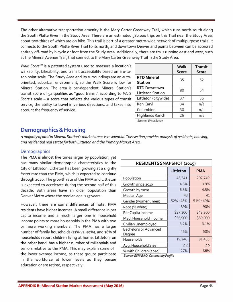
Page 40 APPENDIX B: Mineral Station Market Assessment (May 2016)
The other alternative transportation amenity is the Mary Carter Greenway Trail, which runs north-south along the South Platte River in the Study Area. There are an estimated 580,000 trips on this Trail near the Study Area, about two-thirds of which are on bike. This trail is part of a greater metro-wide network of multipurpose trails. It connects to the South Platte River Trail to its north, and downtown Denver and points between can be accessed entirely off-road by bicycle or foot from the Study Area. Additionally, there are trails running east and west, such as the Mineral Avenue Trail, that connect to the Mary Carter Greenway Trail in the Study Area.
Walk ScoreTM is a patented system used to measure a location’s walkability, bikeability, and transit accessibility based on a 0-to- 100 point scale. The Study Area and its surroundings are an auto- oriented, suburban environment, so the Walk Score is low for Mineral Station. The area is car-dependent. Mineral Station’s transit score of 52 qualifies as “good transit” according to Walk Score’s scale – a score that reflects the various types of transit service, the ability to travel in various directions, and takes into account the frequency of service.
Demographics & Housing
Source: Walk Score
A majority of land in Mineral Station’s market areas is residential. This section provides analysis of residents, housing, and residential real estate for both Littleton and the Primary Market Area.
Demographics The PMA is almost five times larger by population, yet has many similar demographic characteristics to the City of Littleton. Littleton has been growing at a slightly faster rate than the PMA, which is expected to continue through 2020. The growth rate of the PMA and Littleton is expected to accelerate during the second half of this decade. Both areas have an older population than Denver Metro where the median age is 37 years.
However, there are some differences of note. PMA residents have higher incomes. A small difference in per capita income and a much larger one in household income points to more households in the PMA with two or more working members. The PMA has a larger number of family households (71% vs. 59%), and 36% of households report children living at home. Littleton, on the other hand, has a higher number of millennials and seniors relative to the PMA. This may explain some of the lower average income, as these groups participate in the workforce at lower levels as they pursue education or are retired, respectively.
Source: ESRI BAO, Community Profile
Walk Score
Transit Score
RTD Mineral Station
35 52
RTD Downtown Littleton Station
80 54
Littleton (citywide) 37 36 Ken Caryl 34 n/a Columbine 30 n/a Highlands Ranch 26 n/a
RESIDENTS SNAPSHOT (2015) Littleton PMA
Population 43,541 207,749
Growth since 2010 4.3% 3.9% Growth by 2020 6.5% 4.5% Median Age 43 41 Gender (women : men) 52% : 48% 51% : 49%
Race (% white) 89% 90% Per Capita Income $37,300 $43,300 Med. Household Income $56,900 $89,000
Civilian Unemployed 3.2% 3.1% Bachelor's or Advanced Degree
45% 50%
Households 19,246 81,435
Avg. Household Size 2.2 2.5 % with Children (2010) 27% 36%
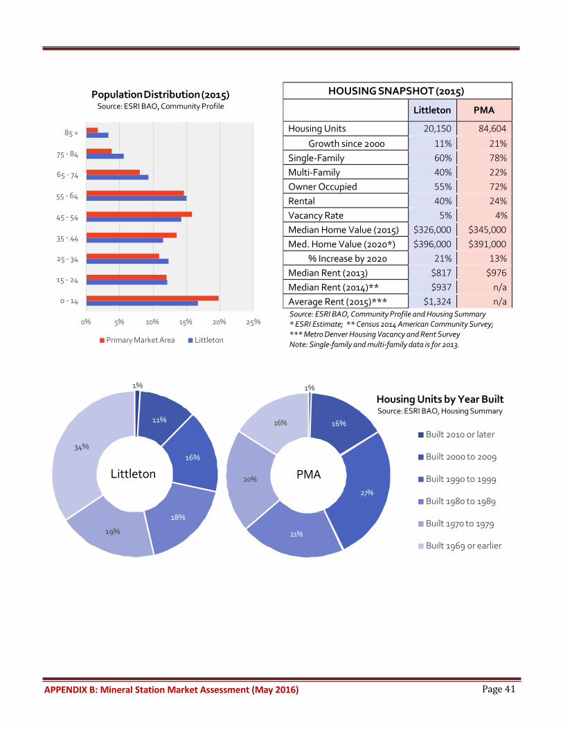
Page 41 APPENDIX B: Mineral Station Market Assessment (May 2016)
85 +
75 - 84
65 - 74
55 - 64
45 - 54
35 - 44
25 - 34
Population Distribution (2015) Source: ESRI BAO, Community Profile
15 - 24
0 - 14
0% 5% 10% 15% 20% 25%
Primary Market Area Littleton
Source: ESRI BAO, Community Profile and Housing Summary * ESRI Estimate; ** Census 2014 American Community Survey; *** Metro Denver Housing Vacancy and Rent Survey Note: Single-family and multi-family data is for 2013.
16%
1%
16%
Housing Units by Year Built Source: ESRI BAO, Housing Summary
Built 2010 or later
20% PMA
27%
Built 2000 to 2009
Built 1990 to 1999
Built 1980 to 1989
21%
Built 1970 to 1979
Built 1969 or earlier
1%
11%
34% 16%
Littleton
18%
19%
HOUSING SNAPSHOT (2015) Littleton PMA
Housing Units 20,150 84,604 Growth since 2000 11% 21%
Single-Family 60% 78% Multi-Family 40% 22% Owner Occupied 55% 72% Rental 40% 24% Vacancy Rate 5% 4% Median Home Value (2015) $326,000 $345,000 Med. Home Value (2020*) $396,000 $391,000
% Increase by 2020 21% 13% Median Rent (2013) $817 $976 Median Rent (2014)** $937 n/a Average Rent (2015)*** $1,324 n/a

Page 42 APPENDIX B: Mineral Station Market Assessment (May 2016)
Housing The PMA housing stock, compared to that of Littleton, can be characterized as newer, more single-family in scale, and more of an owner-occupied market (see tables and graphs on the prior page). Littleton has more of a balanced mix of owner versus rental housing, and single-family versus multi-family housing. The main difference in housing between the two market areas is the age of homes. The PMA went through a housing boom in the 1990s that lasted through the 2000’s. The more historic nature of Littleton is evident by the fact that a third of its homes were built prior to 1970.
There is some evidence that housing units in Littleton are larger than they need to be based on who is currently living there, but sized properly if the goal is to attract more families as nearby areas have successfully done. Over half of housing units have three or more bedrooms (units that are designed and sized for families). Also, less than a quarter of units are one bedroom or studio (more appropriate for people living alone). Meanwhile, the average household size is about two, and only a quarter of households have children, indicating a demand for units with two or fewer bedrooms.
Bedrooms in Unit
Source: 2014 ACS
No BR 1%
Significantly, housing type and costs in Littleton (and less so, the PMA) are expected to change drastically by 2020. Average home values in Littleton are expected to increase 21% between 2015 and 2020, a rapid increase. Further, by 2020 housing prices in Littleton are anticipated to be more expensive than in the surrounding PMA.
Current data on rental rates shows that rental costs are rapidly rising. According to the Census Bureau’s 2014 American Community Survey, median Littleton rent was $937, which is 15% higher than the prior year. Another source, the “Metro Denver Housing Vacancy and Rent Survey,” estimated 2015 average Littleton rent to be $1,324. Using the more conservative 2014 numbers, over 50% of occupied rental units in Littleton are spending 30% or more on rent, meaning that more than half of households are cost burdened and may have difficulty affording other necessities (such as food, transportation, and medical care).
5+ BR 10% 1 BR
4 BR 19%
Littleton
3 BR 23%
2 BR 27%

Page 43 APPENDIX B: Mineral Station Market Assessment (May 2016)
Recent and proposed developments The following table details major housing developments near the Study Area that were recently built, are currently under construction, or are about to begin construction.
Name Status Location Housing Type # of Units # of Bedrooms Pricing
Berkshire Aspen Grove 5
Completed 2011 Within Study Area
Rental apartments 280 1-3 $1,500 - $2,581
(monthly)
Outlook Littleton 6
Completed
2015
S Platte Canyon Rd & W Mineral Ave (1.5 mi west of Mineral Station)
Rental apartments
250
1-2
n/a
HiLine at Littleton Commons 7
Under construction
W County Line Rd (1.5 mi south of Mineral Station)
Rental apartments
385
1-3
$1,195 - $2,052 (monthly)
Littleton Village 8
(former Marathon Oil)
Under
construction
S Broadway & E Dry Creek Rd (2 mi east of Mineral Station)
For-sale SF homes & townhouses; rental apartments
143 (SF) 168 (TH)
352 (Apt.)
3-7 (SF) 2-3 (TH)
TBD (Apt.)
$455,000+ (SF) $320,000+ (TH)
TBD (Apt.)
Sterling Ranch 9
Construction begins 2016
Santa Fe Dr & W Titan Rd (6 mi south of Mineral Station)
3,400-acre mixed-use
Phase 1: 800 SF Full buildout:
12,000
TBD
TBD
SF = Single-Family House TH = Townhouse Apt. = Apartment Unit
The variety of housing information discussed above indicates that housing dynamics in Littleton are changing quickly. There is clearly demand for housing and a significant number of new housing units are being built in the vicinity of the Study Area. With rapidly rising housing costs and many larger units being built, there is reason to be concerned about housing affordability in the near future. It also is important to consider how a more expensive and newer housing stock may change demographics and consumer behaviors.
5 http://www.berkshirecommunities.com/apartments/co/littleton/berkshire-aspen-grove/ 6 http://www.outlooklittleton.com/ 7 http://hilineliving.com/apartments 8 http://www.littletonvillagehomes.com/ 9 Denver Business Journal, “Sterling Ranch breaks ground Saturday,” http://www.bizjournals.com/denver/blog/real_deals/2015/06/sterling-ranch-breaking-ground-saturday.html

Page 44 APPENDIX B: Mineral Station Market Assessment (May 2016)
Employment The Aspen Grove Shopping Center functions as a regional shopping center and the Mineral Avenue Station is primarily used as a Park-n-Ride station for work commuting into downtown Denver. This section examines existing employment and commute characteristics in both market areas, and also commercial real estate data for the area within a one-mile radius of Mineral Station.
Existing Jobs and Workforce The table to the right provides a quick snapshot of the number of businesses and employees within the market areas. In addition to assessing the Littleton and PMA markets, the Study Area also was analyzed where data was pertinent. Virtually all economic activity in the Study Area is occurring at Aspen Grove, so this
EMPLOYMENT SNAPSHOT (2015)
Study Are a Littlet on Primary Market Area
Businesses 8 7 3, 046 8,864
Employees 830 32, 491 82,820 Source: ESRI BAO, Business Summary
shopping center must be understood as an economic generator.
Retail trade employs 7,680 people in Littleton, the highest amongst all industries citywide. Of these, 548 are employed within the Study Area. In other words, approximately 7% of
Top Industries by # of Jobs in Littleton (2015)
Source: ESRI BAO, Business Summary 0% 5% 10% 15% 20%
Retail Trade
retail jobs in Littleton are in the Mineral Station ½ mile Study Area, most of which are at the Aspen Grove Shopping Center. Retail represents 51% of all jobs in the Study Area, compared to 17% citywide.
Very close to the Study Area is a cluster of businesses, located at the northeast intersection of Santa Fe Drive and West County Line Road. There is a wide mix of uses (mostly commercial) including businesses, light industrial uses, multiple auto dealerships, a hotel (with more under development), a church, and a restaurant. This small 1/4 square mile and 342 employees working within these establishments.
Health Care & Social Assistance
Public Administration
Educational Services
Professional, Scientific & Tech Services
Note: The top 5 industries for the PMA are very similar to Littleton, so no chart was included for the PMA.
Top Industries for Littleton Residents (2013) Source: ESRI BAO, Population Summary
0% 5% 10% 15%
Health Care & Social Assistance
Retail Trade
Professional, Scientific & Tech Services
Educational Services
Manufacturing
17%
14% 13%
8% 8%
12%
11%
10%
%
9
8%

Page 45 APPENDIX B: Mineral Station Market Assessment (May 2016)
Top industries in which the Littleton workforce is employed include health care, retail, professional services, education, and manufacturing, as illustrated in the “Top Industries for Littleton Residents” graph on the prior page. New job creation in the Study Area in these industries has the potential to employ Littleton residents.
Commuting More than three quarters of Littleton residents drive alone to work, with an average travel time of 25 minutes. These are high numbers, and point to the large number of people working throughout Denver Metro, rather than near their homes.
As shown in the “Commuting: Inflow & Outflow” map to the right, of all working Littleton residents, only 13% work within the City limits (2,386 people out of 18,415 total). Further, only 8% of people working within Littleton live there (2,386 people out of 29,553 total).
Almost all employees and residents in Littleton are commuting in or out of the City for work, and there are few people who both live and work in Littleton. This commuting pattern equates to transit as an important asset in Littleton. It also suggests that job creation in industries that Littleton residents are already trained for could employ Littleton residents closer to home.
Commercial Real Estate Space Within a one mile radius of Mineral Station, there is over one million square feet of commercial space. As of the fourth quarter of 2015, 8.4% of this was vacant. Commercial real estate is available broken down into office, retail, and “other” (which includes industrial and other unique uses that aren’t traditional office or retail). Of the total commercial square footage, there is 63,000 s.f. of office, 381,000 s.f. of retail, and 622,000 s.f. of “other” commercial. The “other” category has the lowest vacancy rate amongst types of commercial use at only 3.8%.
Office Real Estate Space The 63,000 s.f. of office space is spread across four properties. Of this, 42% is vacant. This vacancy rate has remained stagnant since the fourth quarter of 2014. Given the small supply of office space in the area, it is difficult to draw conclusions about demand for new office development.
Source: ESRI BAO, ACS Population Summary
OFFICE SNAPSHOT (within 1 mi of Mineral Station; Q4 2015)
Supply 62,811 s.f. Vacant 26,499 s.f. Vacancy Rate 42.2% Lease Rate Not available Source: Xceligent
COMMUTING: INFLOW & OUTFLOW Source: Census; www.onthemap.com
Non-residents working in Littleton
Residents working elsewhere
Residents working in Littleton
COMMUTE CHARACTERISTICS (2013)
Littleton Primary Market Area
% Drive alone 77% 79% % Transit 5% 3% Avg. travel time to work 25 min. not available

Page 46 APPENDIX B: Mineral Station Market Assessment (May 2016)
Recent and proposed Developments Two of the major housing developments mentioned in the prior section, Littleton Village and Sterling Ranch, also will include commercial development when fully built out. Littleton Village will include up to 250,000 s.f. of office and retail. It is unknown at this time what proportion of this will be office. Sterling Ranch will likely have office included as well, but is not anticipated in the near-term and full buildout won’t be complete until 2035.
Retail Retail is a critical component of the Study Area. The Study Area also contains one of the largest available vacant sites for potential future retail development. This section reviews major regional retail centers, retail spending and gaps, Littleton revenue from retail sales tax, and retail real estate.
Existing Retail There are two major shopping centers within the City of Littleton – Aspen Grove and Market at Southpark. Both of these are relatively small compared to other nearby shopping centers. Littleton hired Retail Strategies in 2015 to conduct retail market research and provide a strategic retail plan. This plan identified existing niches of retail in Littleton, and also retail categories that are lacking. It honed in on specific areas of the City with retail development potential. The stretch of Santa Fe Drive from Aspen Grove south to C-470 was one of these target areas. The plan identified the Study Area and its surroundings as having potential for big box development.10
10 Retail Strategies, Retail Market Research & Strategic Plan Overview
Major Shopping Centers in the PMA Source: ESRI BAO

Page 47 APPENDIX B: Mineral Station Market Assessment (May 2016)
As previously mentioned, Aspen Grove is located within the Study Area. Its gross leasable area is approximately 272,000 s.f. It has a strong mix of upscale tenants and some of the strongest national brands of all of the shopping centers in the City of Littleton or PMA. Any proposed retail at the Study Area should be positioned in order to protect the upscale brand image of Aspen Grove.
In the PMA, there are nine major shopping centers. There are concentrations of retail along Wadsworth Boulevard and University Boulevard. The largest of these are Southwest Plaza and The Streets at SouthGlenn. The map on the prior page shows locations and size of all major shopping centers in the PMA.
Retail Spending ESRI estimates the total retail spending potential (or demand) for specific geographies. In this definition, retail includes all retail goods, groceries, restaurants, and bars. Using ESRI estimates, both Littleton and PMA households spend more than half of their income on retail (56%, which is also nearly identical to that of the Denver Metro Area as a whole). In Littleton, despite lower incomes than the PMA, there are some factors that increase spending: (1) a large proportion of retired people, who generally have a low current income, but spend accumulated wealth; and (2) young adults, who may still have non-income support for spending and/or who spend in accordance with expected future income.
RETAIL SPENDING (2015)
Littleton Primary Market Area Mean Household Income $78,800 $102,500 Households 19,246 81,435 Retail and Food/Drink Total Potential $850 Million $4.7 Billion Retail/Food & Drink Spending per Household $43,924 $57,796 % of Household Income Spent on Retail 56% 56% Source: ESRI BAO, Retail MarketPlace Profile
Retail Gaps Retail leakage is a measure of unmet demand for goods in a specified area by the residents of that same area. Littleton has a strong retail surplus, meaning customers are drawn in from outside the City to shop and eat. Automobile dealers have the largest surplus of all retail categories in Littleton by far ($550 million in surplus). Other categories with a significant surplus include: clothing stores, furniture stores, miscellaneous stores (stores that do not fall into any of the main categories), and grocery stores. There are not many retail categories with significant leakage in Littleton, where Littleton residents must leave the City of Littleton to shop for certain goods. The one exception is general merchandise stores, where there is estimated leakage of $130 million.
The opposite of Littleton, the PMA has strong retail leakage, meaning that people living in the PMA are mobile and travel for retail, food, and beverage as needed. The industries with the largest leakages in the PMA include general merchandise stores ($270 million in leakage), restaurants and bars ($145 million), and grocery stores ($130 million).
The spending of PMA residents is ripe for capture, considering PMA residents’ willingness to travel for retail and the high percentage of income that PMA households spend on retail.

Page 48 APPENDIX B: Mineral Station Market Assessment (May 2016)
Retail Sales Tax Similar to its peer cities throughout Colorado and the Denver metro region, the City of Littleton relies heavily on sales tax to provide municipal services, and in Littleton’s case almost all of this revenue is made up of retail sales tax. When sales tax is broken down by industry, retail trade represents 50% of all sales tax – by far the largest amongst all industries (next is accommodation/food service at 13%). Littleton’s retail sales tax grew approximately 20% between 2011 and 2015. This shows a significant improvement from the prior five year period (2006-2010) which included the recession, where retail sales tax revenue only grew 6% total.
Aspen Grove is an important revenue generator for Littleton. In 2015, Aspen Grove accounted for 10% of the City of Littleton’s total retail sales tax. This is the highest revenue-producing part of the City by land area. However, total sales tax revenue from Aspen Grove has been stagnant since 2010, and has actually decreased 16% since 2007, when it peaked prior to the recession.
Retail Real Estate Space Within a one mile radius of Mineral Station, there is approximately 381,000 square feet of retail space. A majority of this space is at Aspen Grove, within the Study Area. Of all retail space, 10% is vacant (5% is considered ideal).
This vacancy rate has decreased since a high-point was reported in the first quarter of 2015. Regarding commercial uses, retail has been much healthier than office with the greater Mineral Station Area.
Recent and proposed development
Source: Xceligent
Breckenridge Brewery opened a major facility in mid-2015 just north of the Study Area. The 12-acre complex houses both the brewery and a restaurant. The brewery is 76,000 s.f., while the restaurant adds another 8,000 s.f. Over 200 people work at both businesses. Reported by the Denver Post, and confirmed by the brewery owners, people are using all modes of transportation to travel to the brewery, particularly by bicycle using the adjacent Mary Carter Greenway Trail.11 This illustrates the potential value of the trail network to any future uses in the Study Area. Breckenridge Brewery also could be another attraction for RTD users, if a convenient walkable connection is made between Mineral Station and the brewery.
Other retail developments may come to fruition with the completion of the mixed-use developments discussed earlier in this assessment. The Plaza at the Meadows (the retail component of the Meadows at Platte Valley development) is a 10,000 s.f. retail facility near the intersection of Mineral Avenue and South Platte Canyon Road, west of the Study Area. Littleton Village, east of the Study Area, will contain up to 250,000 s.f. of office and retail (but it is unknown what proportion of this will be each). Retail will be incorporated into the Sterling Ranch master- planned community, but it is likely years before this is built, and square footage and retail type is still uncertain. However, as more homes come online in Littleton and throughout the PMA, their occupants can generate more demand for retail in the Study Area.
11 Denver Post, “Littleton Breckenridge Brewery a hit so far,” http://www.denverpost.com/southjeffco/ci_29129967/littleton-breckenridge-brewery-hit-so-far
RETAIL SNAPSHOT (within 1 mi of Mineral Station; Q4 2015)
Supply 381,131 s.f. Vacant 38,180 s.f. Vacancy Rate 10% Lease Rate $14 (NNN)

Page 49 APPENDIX C: Mineral Light Rail Station Area 2016 Community Engagement
APPENDIX C MINERAL LIGHT RAIL STATION AREA 2016 COMMUNITY ENGAGEMENT
COMMENTS

Page 50 APPENDIX C: Mineral Light Rail Station Area 2016 Community Engagement