mineral resources of the - u.s. geological survey ... creek, about 2.5 mi southeast of ruby moun...
TRANSCRIPT
Mineral Resources of theBrowns Canyon Wilderness Study Area,Chaffee County, Colorado
U.S. GEOLOGICAL SURVEY BULLETIN 1716-C
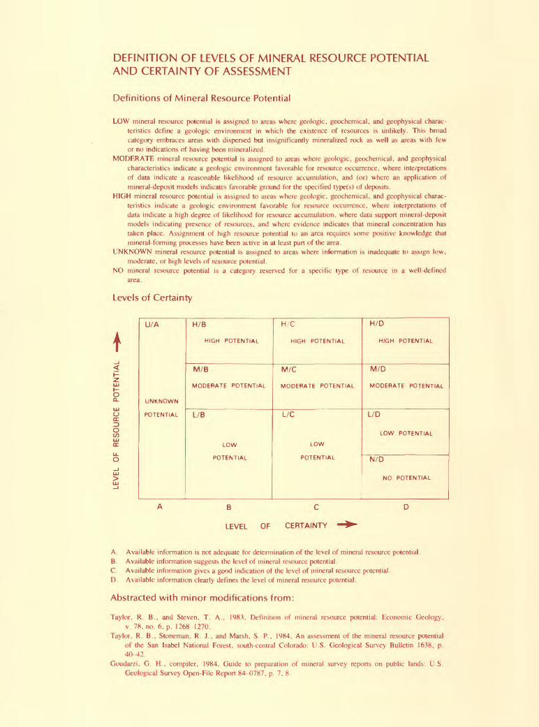
DEFINITION OF LEVELS OF MINERAL RESOURCE POTENTIAL AND CERTAINTY OF ASSESSMENT
Definitions of Mineral Resource Potential
LOW mineral resource potential is assigned to areas where geologic, geochemical, and geophysical charac teristics define a geologic environment in which the existence of resources is unlikely. This broad category embraces areas with dispersed but insignificantly mineralized rock as well as areas with few or no indications of having been mineralized.
MODERATE mineral resource potential is assigned to areas where geologic, geochemical, and geophysical characteristics indicate a geologic environment favorable for resource occurrence, where interpretations of data indicate a reasonable likelihood of resource accumulation, and (or) where an application of mineral-deposit models indicates favorable ground for the specified type(s) of deposits.
HIGH mineral resource potential is assigned to areas where geologic, geochemical, and geophysical charac teristics indicate a geologic environment favorable for resource occurrence, where interpretations of data indicate a high degree of likelihood for resource accumulation, where data support mineral-deposit models indicating presence of resources, and where evidence indicates that mineral concentration has taken place. Assignment of high resource potential to an area requires some positive knowledge that mineral-forming processes have been active in at least pan of the area.
UNKNOWN mineral resource potential is assigned to areas where information is inadequate to assign low, moderate, or high levels of resource potential.
NO mineral resource potential is a category reserved for a specific type of resource in a well-defined area.
Levels of Certainty
U/A
UNKNOWN
POTENTIAL
H/B
HIGH POTENTIAL
M/B
MODERATE POTENTIAL
L/B
LOW
POTENTIAL
H C
HIGH POTENTIAL
M/C
MODERATE POTENTIAL
L/C
LOW
POTENTIAL
H/D
HJGH POTENTIAL
M/D
MODERATE POTENTIAL
L/D
LOW POTENTIAL
N/D
NO POTENTIAL
oCL
OCO
B C
LEVEL OF CERTAINTY
A. Available information is not adequate for determination of the level of mineral resource potential.B. Available information suggests the level of mineral resource potential.C. Available information gives a good indication of the level of mineral resource potential.D. Available information clearly defines the level of mineral resource potential.
Abstracted with minor modifications from:
Taylor, R. B., and Steven, T. A., 1983. Definition of mineral resource potential: Economic Geology,v. 78, no. 6, p. 1268-1270.
Taylor. R. B., Stoneman, R. J., and Marsh. S. P.. 1984. An assessment of the mineral resource potentialof the San Isabel National Forest, south-central Colorado: U.S. Geological Survey Bulletin 1638, p.40-42.
Goudarzi. G. H., compiler, 1984. Guide to preparation of mineral survey reports on public lands: U.S.Geological Survey Open-File Report 84-0787, p. 7, 8.

Chapter C
MINERAL RESOURCES OF WILDERNESS STUDY AREAS SOUTH-CENTRAL COLORADO
Mineral Resources of theBrowns Canyon Wilderness Study Area,Chaffee County, Colorado
By Anne M. Leibold, Ronald G. Worl, and Ronny A. Martin,U.S. Geological Survey, andJeanne E. Zelten, U.S. Bureau of Mines
U.S. GEOLOGICAL SURVEY BULLETIN 1716-C

DEPARTMENT OF THE INTERIOR
DONALD PAUL MODEL, Secretary
U.S. GEOLOGICAL SURVEY
Dallas L. Peck, Director
UNITED STATES GOVERNMENT PRINTING OFFICE, WASHINGTON: 1986
For sale by the Branch of Distribution Books and Open-File Reports Section U.S. Geological Survey Federal Center Box 25425 Denver, CO 80225
Library of Congress Cataloging in Publication Data
Mineral resources of the Browns Canyon Wilderness Study Area, Chaffee County, Colorado.
(Mineral resources of wilderness study areas South-Central Colorado;ch. C) (U.S. Geological Survey bulletin ; 1716-C)
Bibliography: p.Supt. of Docs. No.: I 19.3:1716-C 1. Mines and mineral resources Colorado Browns Canyon
Wilderness. 2. Geology Colorado Browns Canyon Wilderness. 3.Browns Canyon Wilderness (Colo.)
I. Leibold, Anne M. II. Series. III. Series: U.S. Geological Surveybulletin ; 1716-C.
QE75.B9[TN24.C6]
no. 1716-C 557.3 s [553'.09788'47]
86-600166
STUDIES RELATED TO WILDERNESS
Bureau of Land Management Wilderness Study Areas
The Federal Land Policy and Management Act (Public Law 94-579, October 21, 1976) requires the U.S. Geological Survey and the U.S. Bureau of Mines to conduct mineral surveys on certain areas to determine the mineral values, if any, that may be present. Results must be made available to the public and be submitted to the President and the Congress. This report presents the results of a mineral survey of the Browns Canyon (CO-050-002) Wilderness Study Area, Chaffee County, Colorado.

RESOURCE/RESERVE CLASSIFICATION
IDENTIFIED RESOURCES
Demonstrated
Measured IndicatedInferred
UNDISCOVERED RESOURCES
Hypothetical
Probability Range '(or)'
Speculative
ECONOMIC
MARGINALLY
ECONOMIC
SUB-
ECONOMIC
Reserves Inferred Reserves
Marginal Reserves
Demonstrated Subeconomic Resources
Inferred Marginal Reserves
InferredSubeconomic
Resources
+
Major elements of mineral resource classification, excluding reserve base and inferred reserve base. Modified from U. S. Bureau of Mines and U. S. Geological Survey, 1980, Principles of a resource/reserve classification for minerals: U. S. Geological Survey Circular 831, p. 5.
IV
CONTENTS
Summary 1 Introduction 3
Investigation by the U.S. Bureau of Mines 3 Investigation by the U.S. Geological Survey 4
Appraisal of identified resources 4Mining and mineral-exploration activity 4
Geothermal resources 5 Oil and gas 5
Appraisal of sites examined 5Perlite and associated rocks 5
Ruby Mountain deposit 5 Cottonwood Creek deposit 7
Rock and mineral specimens 7 Sand and gravel 7
Assessment of potential for undiscovered resources 8 Geology 8
Geologic setting 8 Description of rock units 8
Geochemistry 9Analytical methods 9 Results of survey 9
Geophysics 10Mineral and energy resources 10
References cited 13
PLATE
(In pocket)
1. Map showing mineral resource potential, geology, and geochemical sample localities of the Browns Canyon Wilderness Study Area
FIGURES
1. Map showing mineral resource potential and generalized geology of the Browns Canyon Wilderness Study Area 2
2. Index map showing the location of the Browns Canyon Wilderness Study Area 3
3. Map showing oil and gas lease application and Browns Canyon thermal area near the Browns Canyon Wilderness Study Area 6
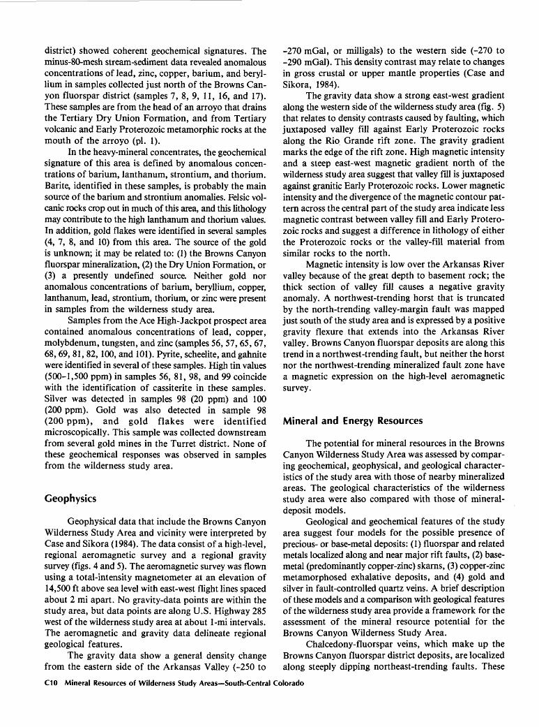
4. Aeromagnetic contour map of the Browns Canyon Wilderness Study Area 11
5. Gravity contour map of the Browns Canyon Wilderness Study Area 12
Contents V

MINERAL RESOURCES OF WILDERNESS STUDY AREAS-SOUTH-CENTRAL COLORADO
Mineral Resources of theBrowns Canyon Wilderness Study Area,Chaffee County, ColoradoBy Anne M. Leibold, Ronald G. Worl, and Ronny A. Martin U.S. Geological Survey and Jeanne E. Zelten U.S. Bureau of Mines
SUMMARY
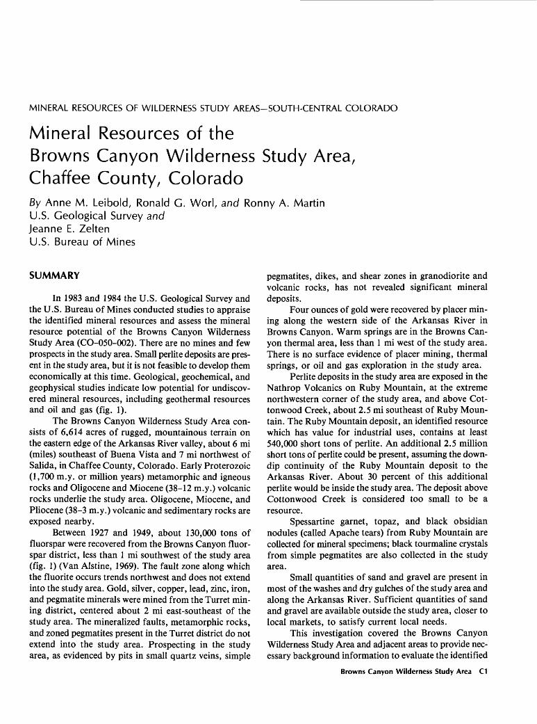
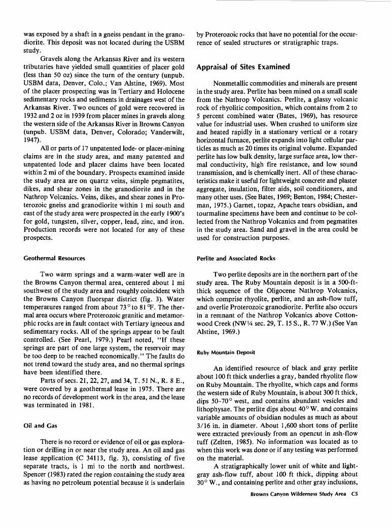
In 1983 and 1984 the U.S. Geological Survey and the U.S. Bureau of Mines conducted studies to appraise the identified mineral resources and assess the mineral resource potential of the Browns Canyon Wilderness Study Area (CO-050-002). There are no mines and few prospects in the study area. Small perlite deposits are pres ent in the study area, but it is not feasible to develop them economically at this time. Geological, geochemical, and geophysical studies indicate low potential for undiscov ered mineral resources, including geothermal resources and oil and gas (fig. 1).
The Browns Canyon Wilderness Study Area con sists of 6,614 acres of rugged, mountainous terrain on the eastern edge of the Arkansas River valley, about 6 mi (miles) southeast of Buena Vista and 7 mi northwest of Salida, in Chaffee County, Colorado. Early Proterozoic (1,700 m.y. or million years) metamorphic and igneous rocks and Oligocene and Miocene (38-12 m.y.) volcanic rocks underlie the study area. Oligocene, Miocene, and Pliocene (38-3 m.y.) volcanic and sedimentary rocks are exposed nearby.
Between 1927 and 1949, about 130,000 tons of fluorspar were recovered from the Browns Canyon fluor spar district, less than 1 mi southwest of the study area (fig. 1) (Van Alstine, 1969). The fault zone along which the fluorite occurs trends northwest and does not extend into the study area. Gold, silver, copper, lead, zinc, iron, and pegmatite minerals were mined from the Turret min ing district, centered about 2 mi east-southeast of the study area. The mineralized faults, metamorphic rocks, and zoned pegmatites present in the Turret district do not extend into the study area. Prospecting in the study area, as evidenced by pits in small quartz veins, simple
pegmatites, dikes, and shear zones in granodiorite and volcanic rocks, has not revealed significant mineral deposits.
Four ounces of gold were recovered by placer min ing along the western side of the Arkansas River in Browns Canyon. Warm springs are in the Browns Can yon thermal area, less than 1 mi west of the study area. There is no surface evidence of placer mining, thermal springs, or oil and gas exploration in the study area.
Perlite deposits in the study area are exposed in the Nathrop Volcanics on Ruby Mountain, at the extreme northwestern corner of the study area, and above Cot- tonwood Creek, about 2.5 mi southeast of Ruby Moun tain. The Ruby Mountain deposit, an identified resource which has value for industrial uses, contains at least 540,000 short tons of perlite. An additional 2.5 million short tons of perlite could be present, assuming the down- dip continuity of the Ruby Mountain deposit to the Arkansas River. About 30 percent of this additional perlite would be inside the study area. The deposit above Cottonwood Creek is considered too small to be a resource.
Spessartine garnet, topaz, and black obsidian nodules (called Apache tears) from Ruby Mountain are collected for mineral specimens; black tourmaline crystals from simple pegmatites are also collected in the study area.
Small quantities of sand and gravel are present in most of the washes and dry gulches of the study area and along the Arkansas River. Sufficient quantities of sand and gravel are available outside the study area, closer to local markets, to satisfy current local needs.
This investigation covered the Browns Canyon Wilderness Study Area and adjacent areas to provide nec essary background information to evaluate the identified
Browns Canyon Wilderness Study Area C1
106°00'
RUBY MOUNTAIN APPROXIMATE BOUNDARY OF
xgd THE BROWNS CANYONWILDERNESS STUDY AREA
(CO-050-002)
BROWNS CANYON FLUORSPAR DISTRICT
TURRET MINING
DISTRICT
xAce High - Jackpot X9n Prospect
30"
Figure 1 (above and facing page). Map showing mineral resource potential and generalized geology of the Browns Canyon Wilderness Study Area, Chaffee County, Colorado (geology modified from Scott and others, 1975).
C2 Mineral Resources of Wilderness Study Areas South-Central Colorado
EXPLANATION
^ Mine having identified resources of perlite
L/C Geologic terrane having low mineral resource potential for all metals, industrial minerals, and geothermal energy, with certainty level C Applies to entire study area
L/D Geologic terrane having low mineral resource potential for oil and gas, with certainty level D
Qal Alluvium (Quaternary)
Td Dry Union Formation (Pliocene and Miocene)
TV Fclsic volcanic rocks (Miocene and Oligocene)
Xgd Granodiorite (Early Proterozoic)
Xgn Quartz-feldspar-biotite gneiss (Early Proter ozoic)
^ Contact
^^^« Fault Dashed where approximately located; dotted where cohcealed. Bar and ball on downthrown side
mineral resources and to assess the potential for undis covered mineral resources. The USBM (U.S. Bureau of Mines) collected 58 rock samples from prospects, pegmatites, and perlite occurrences in or near the study area. Chip samples were taken across altered and miner alized structures; grab or select samples were taken of mine-dump material. The USGS (U.S. Geological Survey) investigation included a review of previous geological studies, collection and analysis of stream-sediment samples from 123 sites from the study area and proximity, and a search for mines, prospects, and mineralized areas. Analyses of the geochemical samples indicated no areas with significant concentrations of metals in the study area. Geological, geochemical, and geophysical charac teristics of the study area indicate a low mineral resource potential for mineral and geothermal resources, and no potential for oil and gas resources.
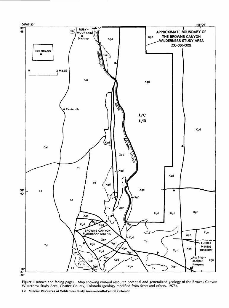
INTRODUCTION
In 1983 and 1984 the USGS and the USBM studied 6,614 acrefs of the Browns Canyon Wilderness Study Area (CO-050-002), Chaffee County, Colorado. The study of this acreage was requested by the BLM (U.S. Bureau of Land Management). In this report the studied area is called the "wilderness study area" or simply the "study area."
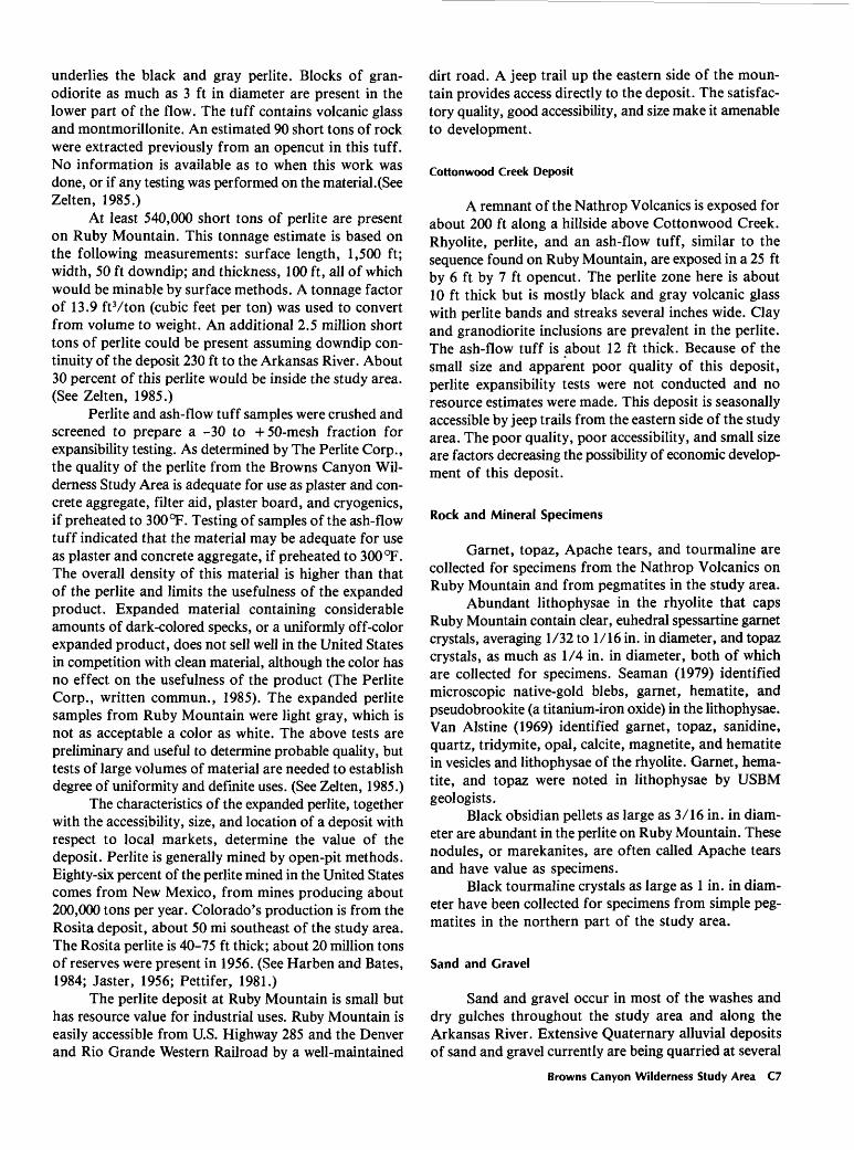
The Browns Canyon Wilderness Study Area, about 6 mi south of Buena Vista and 7 mi northwest of Salida (fig. 2), includes rugged, mountainous terrain with eleva tions ranging from about 7,400 ft (feet) along the Arkansas River to 9,082 ft in the eastern part of the study area. Many intermittent streams drain the study area,
106°02'30' 106°00'
APPROXIMATE BOUNDARY OF THE BROWNS CANYON WILDERNESS STUDY AREA
SALIDA 6 MILES
Figure 2. Index map showing the location of the Browns Canyon Wilderness Study Area, Chaffee County, Colorado.
flowing into the Arkansas River. The study area is accessi ble by foot from dirt roads to the east, and by boat along the Arkansas River from the west.
Investigation by the U.S. Bureau of Mines
Prior to field investigation in 1983 and 1984, USBM geologists reviewed published and unpublished literature for information regarding the Browns Canyon Wilderness Study Area. Local residents and personnel from the
Browns Canyon Wilderness Study Area C3
USBM, USGS, and BLM were interviewed regarding minerals in and near the study area. BLM records in Denver and Salida, and county records in Salida were examined for locations of mining claims and mineral leases in and near the wilderness study area.
Mines, prospects, and pegmatite and perlite out crops in and within 1 mi of the study-area boundary were mapped and sampled. Chip samples were taken across altered and mineralized structures; grab or select samples were taken of mine-dump material. A total of 58 samples was collected. Except for four perlite and tuff samples, which were sent to The Perlite Corp. (Aston, Penn.) for special testing, all samples were analyzed for gold and silver by fire assay, and by semiquantitative optical- emission spectrographic methods for 40 elements. Various other analyses were performed on selected samples to determine concentrations of specific suspected elements. Chemical analysis was used to determine fluorine con tent. Atomic-absorption spectrophotometry was used to determine copper, lead, and zinc, fluorometry was used for uranium, and X-ray fluorescence was used for tungsten. X-ray diffraction was used to determine mont- morillonite. These analyses were performed by the USBM Reno Research Center, Reno, Nev. (See Zelten, 1985.)
Four samples of perlite and tuff from the Nathrop Volcanics were expanded and tested by The Perlite Corp. to determine their quality and suitability for industrial uses. The samples were crushed and screened to -30 to -50-mesh, then expanded in a laboratory perlite expander at standard settings with both no preheating and after preheating at 300 °F and 600 °F. The density of the result ing expanded product was used to determine suitability for industrial uses.
Investigation by the U.S. Geological Survey
In June and July 1984, the USGS conducted field investigations to assess the potential for undiscovered mineral resources of the Browns Canyon Wilderness Study Area. This investigation included a field check of the previous geological mapping and field studies, a stream-sediment geochemical survey, and an examination of mineralized and altered areas.
The geology and known mineral deposits of the Poncha Springs NE quadrangle, which includes the wilderness study area, were described by Van Alstine (1969). A geologic map at 1:24,000 scale is included in Van Alstine's publication. Scott and others (1975) also described the geology of the wilderness study area; a l:62,500-scale geologic map accompanies their report. The geologic maps in this report (fig. 1, pi. 1) are mod ified compilations of these previous maps. Mineral resource potential was classified according to the sys tem of Goudarzi (1984) (see inside front cover of this report).
Acknowledgments. We appreciate the work done by M. S. Alien, R. C. Davies, and P. K. Mowinckel, who assisted in the field study, and D. E. Detra and J. M. Motooka for their analyses of the geochemical samples.
APPRAISAL OF IDENTIFIED RESOURCES By Jeanne E. Zelten, U.S. Bureau of Mines
Mining and Mineral-Exploration Activity
The Browns Canyon Wilderness Study area is not included in any mining district. The Browns Canyon fluorspar district, about 0.25 mi southwest of the study area (parts of sees. 22, 23, 26, 27, and 34, T. 51 N., R. 8 E.), has been one of the principal fluorspar mining districts in the United States (Van Alstine, 1976). The fluorspar was discovered in the early 1920's, and about 130,000 short tons were recovered between 1927 and 1949. Two of four flotation mills previously in operation in the district still stand but are in disrepair. Fluorspar deposits are large and mine workings were extensive. According to Van Alstine (1969), estimated resources of the district are about 2 million short tons of ore, containing at least 15 percent fluorspar. The faults along which the fluorspar occurs trend northwest and dip southwest. (See Van Alstine, 1969.) No surface evidence of fluorspar was observed in the study area by either Van Alstine or the USBM; the mineralized structures studied by Van Alstine do not trend toward the study area.
Since the mid-1800's, copper, gold, silver, iron, and pegmatite minerals have been mined from Early Protero- zoic gneisses and schist, skarns, and complex and zoned pegmatites, and along fault zones in the Turret mining district, southeast of the study area. The district is centered around Turret, which is about 2 mi east- southeast of the study area (parts of sees. 27, 28, 29, 32, 33, and 34, T. 51 N., R. 9 E.). More than 5,700 Ib (pounds) of copper, 42 oz (ounces) of gold, and 100 oz of silver were recovered; unknown quantities of iron, beryl, mica, and rare earths also were mined. Proterozoic granodiorite and simple pegmatites in the Browns Canyon Wilderness Study Area are not related to the mineralized structures in the Turret district. (See unpub. USBM data, Denver, Colo.; Del Rio, 1960; Eckel, 1961; Vanderwilt, 1947.)
Simple pegmatites and quartz veins in and near the study area have been prospected for quartz, feldspar, and other mineral specimens, chiefly black tourmaline crystals as large as 1 in. (inch) in diameter. Small quartzite occur rences within 1 mi east of the study area were quarried in 1961-62 for use in aggregate and as decorative stone. Van Alstine (1969) described a vermiculite deposit of unspecified dimensions in the study area (SW^SW!^ sec. 29, T. 15 S., R. 77 W.). He reported that the deposit
C4 Mineral Resources of Wilderness Study Areas South-Central Colorado
was exposed by a shaft in a gneiss pendant in the grano- diorite. This deposit was not located during the USBM study.
Gravels along the Arkansas River and its western tributaries have yielded small quantities of placer gold (less than 50 oz) since the turn of the century (unpub. USBM data, Denver, Colo.; Van Alstine, 1969). Most of the placer prospecting was in Tertiary and Holocene sedimentary rocks and sediments in drainages west of the Arkansas River. Two ounces of gold were recovered in 1932 and 2 oz in 1939 from placer mines in gravels along the western side of the Arkansas River in Browns Canyon (unpub. USBM data, Denver, Colorado; Vanderwilt, 1947).
All or parts of 17 unpatented lode- or placer-mining claims are in the study area, and many patented and unpatented lode and placer claims have been located within 2 mi of the boundary. Prospects examined inside the study area are on quartz veins, simple pegmatites, dikes, and shear zones in the granodiorite and in the Nathrop Volcanics. Veins, dikes, and shear zones in Pro- terozoic gneiss and granodiorite within 1 mi south and east of the study area were prospected in the early 1900's for gold, tungsten, silver, copper, lead, zinc, and iron. Production records were not located for any of these prospects.
by Proterozoic rocks that have no potential for the occur rence of sealed structures or stratigraphic traps.
Appraisal of Sites Examined
Nonmetallic commodities and minerals are present in the study area. Perlite has been mined on a small scale from the Nathrop Volcanics. Perlite, a glassy volcanic rock of rhyolitic composition, which contains from 2 to 5 percent combined water (Bates, 1969), has resource value for industrial uses. When crushed to uniform size and heated rapidly in a stationary vertical or a rotary horizontal furnace, perlite expands into light cellular par ticles as much as 20 times its original volume. Expanded perlite has low bulk density, large surface area, low ther mal conductivity, high fire resistance, and low sound transmission, and is chemically inert. All of these charac teristics make it useful for lightweight concrete and plaster aggregate, insulation, filter aids, soil conditioners, and many other uses. (See Bates, 1969; Benton, 1984; Chester- man, 1975.) Garnet, topaz, Apache tears obsidian, and tourmaline specimens have been and continue to be col lected from the Nathrop Volcanics and from pegmatites in the study area. Sand and gravel in the area could be used for construction purposes.
Geothermal Resources
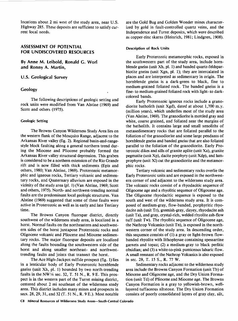
Two warm springs and a warm-water well are in the Browns Canyon thermal area, centered about 1 mi southwest of the study area and roughly coincident with the Browns Canyon fluorspar district (fig. 3). Water temperatures ranged from about 73° to 81 °F. The ther mal area occurs where Proterozoic granitic and metamor- phic rocks are in fault contact with Tertiary igneous and sedimentary rocks. All of the springs appear to be fault controlled. (See Pearl, 1979.) Pearl noted, "If these springs are part of one large system, the reservoir may be too deep to be reached economically." The faults do not trend toward the study area, and no thermal springs have been identified there.
Parts of sees. 21, 22, 27, and 34, T. 51 N., R. 8 E., were covered by a geothermal lease in 1975. There are no records of development work in the area, and the lease was terminated in 1981.
Oil and Gas
There is no record or evidence of oil or gas explora tion or drilling in or near the study area. An oil and gas lease application (C 34113, fig. 3), consisting of five separate tracts, is 1 mi to the north and northwest. Spencer (1983) rated the region containing the study area as having no petroleum potential because it is underlain
Perlite and Associated Rocks
Two perlite deposits are in the northern part of the study area. The Ruby Mountain deposit is in a 500-ft- thick sequence of the Oligocene Nathrop Volcanics, which comprise rhyolite, perlite, and an ash-flow tuff, and overlie Proterozoic granodiorite. Perlite also occurs in a remnant of the Nathrop Volcanics above Cotton- wood Creek (NW!4 sec. 29, T. 15 S., R. 77 W.) (See Van Alstine, 1969.)
Ruby Mountain Deposit
An identified resource of black and gray perlite about 100 ft thick underlies a gray, banded rhyolite flow on Ruby Mountain. The rhyolite, which caps and forms the western side of Ruby Mountain, is about 300 ft thick, dips 50-70° west, and contains abundant vesicles and lithophysae. The perlite dips about 40° W. and contains variable amounts of obsidian nodules as much as about 3/16 in. in diameter. About 1,600 short tons of perlite were extracted previously from an opencut in ash-flow tuff (Zelten, 1985). No information was located as to when this work was done or if any testing was performed on the material.
A stratigraphically lower unit of white and light- gray ash-flow tuff, about 100 ft thick, dipping about 30° W., and containing perlite and other gray inclusions,
Browns Canyon Wilderness Study Area C5

R.78W. R.77W. 106°00'
38°45' -
To Buena Vista
APPROXIMATE BOUNDARY OFTHE BROWNS CANYON
WILDERNESS STUDY AREA
ASugarloaf Mtn
^APPROXIMATE BOUNDARY OF \T THE BROWNS CANYON
THERMAL AREA
T.14S.
R.7E.
T.15S.
T.51N.
T.50N.
R.8E. R.9E.
2 Ml J
EXPLANATION
Area of oil and gas lease application C 34113 Warm spring
Warm-water well
Figure 3. Map showing oil and gas lease application and Browns Canyon thermal area near the Browns Canyon Wilderness Study Area, Colorado. Lease application data from U.S. Bureau of Land Management, 1984. Thermal-area data modified from Pearl (1979). C6 Mineral Resources of Wilderness Study Areas South-Central Colorado
underlies the black and gray perlite. Blocks of gran- odiorite as much as 3 ft in diameter are present in the lower part of the flow. The tuff contains volcanic glass and montmorillonite. An estimated 90 short tons of rock were extracted previously from an opencut in this tuff. No information is available as to when this work was done, or if any testing was performed on the material.(See Zelten, 1985.)
At least 540,000 short tons of perlite are present on Ruby Mountain. This tonnage estimate is based on the following measurements: surface length, 1,500 ft; width, 50 ft downdip; and thickness, 100 ft, all of which would be minable by surface methods. A tonnage factor of 13.9 ftVton (cubic feet per ton) was used to convert from volume to weight. An additional 2.5 million short tons of perlite could be present assuming downdip con tinuity of the deposit 230 ft to the Arkansas River. About 30 percent of this perlite would be inside the study area. (See Zelten, 1985.)
Perlite and ash-flow tuff samples were crushed and screened to prepare a -30 to +50-mesh fraction for expansibility testing. As determined by The Perlite Corp., the quality of the perlite from the Browns Canyon Wil derness Study Area is adequate for use as plaster and con crete aggregate, filter aid, plaster board, and cryogenics, if preheated to 300 °F. Testing of samples of the ash-flow tuff indicated that the material may be adequate for use as plaster and concrete aggregate, if preheated to 300 °F. The overall density of this material is higher than that of the perlite and limits the usefulness of the expanded product. Expanded material containing considerable amounts of dark-colored specks, or a uniformly off-color expanded product, does not sell well in the United States in competition with clean material, although the color has no effect on the usefulness of the product (The Perlite Corp., written commun., 1985). The expanded perlite samples from Ruby Mountain were light gray, which is not as acceptable a color as white. The above tests are preliminary and useful to determine probable quality, but tests of large volumes of material are needed to establish degree of uniformity and definite uses. (See Zelten, 1985.)
The characteristics of the expanded perlite, together with the accessibility, size, and location of a deposit with respect to local markets, determine the value of the deposit. Perlite is generally mined by open-pit methods. Eighty-six percent of the perlite mined in the United States comes from New Mexico, from mines producing about 200,000 tons per year. Colorado's production is from the Rosita deposit, about 50 mi southeast of the study area. The Rosita perlite is 40-75 ft thick; about 20 million tons of reserves were present in 1956. (See Harben and Bates, 1984; Jaster, 1956; Pettifer, 1981.)
The perlite deposit at Ruby Mountain is small but has resource value for industrial uses. Ruby Mountain is easily accessible from U.S. Highway 285 and the Denver and Rio Grande Western Railroad by a well-maintained
dirt road. A jeep trail up the eastern side of the moun tain provides access directly to the deposit. The satisfac tory quality, good accessibility, and size make it amenable to development.
Cottonwood Creek Deposit
A remnant of the Nathrop Volcanics is exposed for about 200 ft along a hillside above Cottonwood Creek. Rhyolite, perlite, and an ash-flow tuff, similar to the sequence found on Ruby Mountain, are exposed in a 25 ft by 6 ft by 7 ft opencut. The perlite zone here is about 10 ft thick but is mostly black and gray volcanic glass with perlite bands and streaks several inches wide. Clay and granodiorite inclusions are prevalent in the perlite. The ash-flow tuff is about 12 ft thick. Because of the small size and apparent poor quality of this deposit, perlite expansibility tests were not conducted and no resource estimates were made. This deposit is seasonally accessible by jeep trails from the eastern side of the study area. The poor quality, poor accessibility, and small size are factors decreasing the possibility of economic develop ment of this deposit.
Rock and Mineral Specimens
Garnet, topaz, Apache tears, and tourmaline are collected for specimens from the Nathrop Volcanics on Ruby Mountain and from pegmatites in the study area.
Abundant lithophysae in the rhyolite that caps Ruby Mountain contain clear, euhedral spessartine garnet crystals, averaging 1/32 to 1/16 in. in diameter, and topaz crystals, as much as 1/4 in. in diameter, both of which are collected for specimens. Seaman (1979) identified microscopic native-gold blebs, garnet, hematite, and pseudobrookite (a titanium-iron oxide) in the lithophysae. Van Alstine (1969) identified garnet, topaz, sanidine, quartz, tridymite, opal, calcite, magnetite, and hematite in vesicles and lithophysae of the rhyolite. Garnet, hema tite, and topaz were noted in lithophysae by USBM geologists.
Black obsidian pellets as large as 3/16 in. in diam eter are abundant in the perlite on Ruby Mountain. These nodules, or marekanites, are often called Apache tears and have value as specimens.
Black tourmaline crystals as large as 1 in. in diam eter have been collected for specimens from simple peg matites in the northern part of the study area.
Sand and Gravel
Sand and gravel occur in most of the washes and dry gulches throughout the study area and along the Arkansas River. Extensive Quaternary alluvial deposits of sand and gravel currently are being quarried at several
Browns Canyon Wilderness Study Area C7
locations about 2 mi west of the study area, near U.S. Highway 285. These deposits are sufficient to satisfy cur rent local needs.
ASSESSMENT OF POTENTIAL FOR UNDISCOVERED RESOURCES
By Anne M. Leibold, Ronald G. Worl and Ronny A. Martin,
U.S. Geological Survey
Geology
The following descriptions of geologic setting and rock units were modified from Van Alstine (1969) and Scott and others (1975).
Geologic Setting
The Browns Canyon Wilderness Study Area lies on the western flank of the Mosquito Range, adjacent to the Arkansas River valley (fig. 2). Regional basin-and-range- style block faulting along a general northern trend dur ing the Miocene and Pliocene probably formed the Arkansas River valley structural depression. This graben is considered to be a northern extension of the Rio Grande rift and is now filled with thick sediments (Epis and others, 1980; Van Alstine, 1969). Proterozoic metamor- phic and igneous rocks, Tertiary volcanic and sedimen tary rocks, and Quaternary alluvium are exposed in the vicinity of the study area (pi. 1) (Van Alstine, 1969; Scott and others, 1975). North- and northwest-trending normal faults are the predominant local geologic structures. Van Alstine (1969) suggested that some of these faults were active in Proterozoic as well as in early and late Tertiary time.
The Browns Canyon fluorspar district, directly southwest of the wilderness study area, is localized in a horst. Normal faults on the northeastern and southwest ern sides of the horst juxtapose Proterozoic rocks and Oligocene volcanic and Pliocene and Miocene sedimen tary rocks. The major fluorspar deposits are localized along the faults bounding the southwestern side of the horst and along smaller northeast- and northwest- trending faults and joints that transect the horst.
The Ace High-Jackpot sulfide prospect (fig. 1) lies in a lenticular body of Early Proterozoic hornblende gneiss (unit Xh, pi. 1) bounded by two north-trending faults in the NWV4 sec. 32, T. 51 N., R. 9 E. This pros pect is in the western part of the Turret mining district, centered about 2 mi southeast of the wilderness study area. This district includes many mines and prospects in sees. 28, 29, 31, and 32 (T. 51 N., R. 9 E.). Most notable
are the Gold Bug and Golden Wonder mines character ized by gold in fault-controlled quartz veins, and the Independence and Turret deposits, which were described as copper-zinc skarns (Heinrich, 1981; Lindgren, 1908).
Description of Rock Units
Early Proterozoic metamorphic rocks, exposed in the southwestern part of the study area, include horn blende gneiss (unit Xh, pi. 1) and banded quartz-feldspar- biotite gneiss (unit Xgn, pi. 1); they are intercalated in places and are interpreted as sedimentary in origin. The hornblende gneiss is a dark-green to black, fine to medium-grained foliated rock. The banded gneiss is a fine- to medium-grained foliated rock with light- to dark- colored bands.
Early Proterozoic igneous rocks include a grano- diorite batholith (unit Xgd), dated at about 1,700 m.y. (million years), which underlies most of the study area (Van Alstine, 1969). The granodiorite is mottled gray and white, coarse grained, and foliated near the margins of the batholith. It contains large and small xenoliths of metasedimentary rocks that are foliated parallel to the foliation of the granodiorite and some large pendants of hornblende gneiss and banded gneiss that are also foliated parallel to the foliation of the granodiorite. Early Pro terozoic dikes and sills of granite aplite (unit Xa), granite pegmatite (unit Xp), dacite porphyry (unit Xdp), and lam- prophyre (unit XI) cut the granodiorite and the metamor phic rocks.
Tertiary volcanic and sedimentary rocks overlie the Early Proterozoic units and are exposed in the northwest ern corner of and adjacent to the wilderness study area. The volcanic rocks consist of a rhyodacitic sequence of Oligocene age and a rhyolitic sequence of Oligocene age. The Oligocene rhyodacitic sequence is exposed to the south and west of the wilderness study area. It is com posed of medium-gray, flow-banded, porphyritic rhyo- dacite ash (unit Tr), greenish-gray, clayey, rhyodacite ash (unit Ta), and gray, crystal-rich, welded rhyolite ash-flow tuff (unit Tw). The rhyolitic sequence of Oligocene age, the Nathrop Volcanics (unit Tn), is exposed in the north western corner of the study area. In descending order, this sequence consists of (1) a gray or light-brown flow- banded rhyolite with lithophysae containing spessartine garnets and topaz; (2) a medium-gray to black perlitic obsidian; and (3) a white-to-pink pumiceous laharic flow. A small remnant of the Nathrop Volcanics is also exposed in sec. 29, T. 15 S., R. 77 W.
Sedimentary rocks adjacent to the wilderness study area include the Browns Canyon Formation (unit Tb) of Miocene and Oligocene age, and the Dry Union Forma tion (unit Td) of Pliocene and Miocene age. The Browns Canyon Formation is a gray to yellowish-brown, well- layered tuffaceous siltstone. The Dry Union Formation consists of poorly consolidated layers of gray clay, silt,
C8 Mineral Resources of Wilderness Study Areas South-Central Colorado
sand, and gravel. Volcanic lithologies predominate in the gravels, but Precambrian rock fragments are also present.
Quaternary alluvium (unit Qal) is present along the Arkansas River banks and in the Arkansas Valley.
Geochemistry
A geochemical survey to evaluate the mineral resource potential of the Browns Canyon Wilderness Study Area included the collection and analysis of stream- sediment samples and heavy-mineral concentrates from 123 sites in and adjacent to the wilderness study area (pi. 1). The sample density in the wilderness study area averaged 3 samples per square mile. The two known mineralized districts adjacent to the wilderness study area, the Browns Canyon fluorspar district (sees. 22, 23, 26, 27, 34, and 35, T. 51 N., R. 8 E.) and the Turret district (sees. 27, 28, 29, 32, 33, and 34, T. 51 N., R. 9 E.) were sampled to characterize the geochemical response of these districts and to assist in the recognition of similar mineralized areas within the wilderness study area. In the Turret district, emphasis was placed on characterizing the response of the Ace High-Jackpot prospect in sec. 32. Well-developed drainages in these two mineralized districts were sampled about every 0.25 mi. Bulk stream sediments and panned concentrates were collected at each site. Each sample represents a composite collection of stream sediment.
Analytical Methods
At each sample site about 1.6 kg (kilograms) of stream sediment were collected from point bars or sec tions of lower gradient to constitute the bulk samples. This material was dried and sieved to minus-80 mesh. A 0.5-g (gram) sample was digested in an aqua regia (1HNO3 :3HC1) solution, dried by heating, then cooled. The residue was then redissolved in 20 mL (milliliters) of 20 percent HC1 and warmed on a hot plate. This solution was filtered into a test tube and analyzed by inductively coupled plasma atomic-emission spectroscopy (ICP) (Church, 1981) for Al, Ca, Fe, Mg, Ag, As, B, Ba, Be, Bi, Ce, Cd, Co, Cr, Cu, La, Mn, Mo, Nb, Ni, P, Pb, Sb, Sn, Sr, Ti, V, W, Y, and Zn.
To obtain the heavy-mineral concentrates, about 7 kg of sediment was collected from riffle gravels and screened through a 10-mesh stainless-steel screen at each sample site. The sediment was panned until about 50 per cent quartz and feldspar remained in the concentrate. This material was dried, sieved to minus-30 mesh, and was processed through bromoform (specific gravity 2.85-2.89) and a modified Frantz isodynamic separator 1 to obtain
'Use of trade names in this report is for descriptive purposes only and does not imply endorsement by the U.S. Geological Survey.
three fractions: (1) magnetic at 0.25 A (ampere), (2) magnetic at 1.2 A, and (3) nonmagnetic at 1.2 A. The non magnetic fraction was split, ground with a mortar and pestle, and analyzed semiquantitatively for 31 elements (Fe, Mg, Ca, Ti, Mn, Ag, As, Au, B, Ba, Be, Bi, Cd, Co, Cr, Cu, La, Mo, Nb, Ni, Pb, Sb, Sc, Sn, Sr, V, W, Y, Zn, Zr, and Th) by the six-step optical-emission spectrographic method (Grimes and Marranzino, 1968).
Samples having anomalous metal concentrations were determined and evaluated, primarily using raw-data listings, basic statistics, histograms, single-element plots, and R-mode factor analysis. The purpose was to deter mine anomalous metal concentrations and to detect ele ment associations that may reflect geologic processes or features, such as underlying lithology, mineralization, and geochemical-dispersion processes. Binocular-microscope examination of the mineralogy of the heavy-mineral con centrates augmented data interpretation. A brief summary of the procedures and conclusions are presented below; however, a complete review of the data and interpretation is available in the files of the USGS.
Results of Survey
Interpretation of the geochemical data using classical geochemical concepts (Goldschmidt, 1954) and a variety of statistical methods identified no indication of mineralized rock in the wilderness study area.
Minus-80-mesh samples 45, 46, 104, 105, 106, 107, 141, and 143, from the northern part of the wilderness study area (pi. 1), possess anomalous values for the geochemical association V-Cr-Fe-P-Nb-Co-Ni. These anomalous values probably indicate the high content of magnetite, amphibole, biotite, and monazite in the granodiorite. The amphibole, biotite, and monazite enrich ment in this area was also reflected markedly in the panned concentrates, mineralogically and chemically. Samples 45, 46, 48, 104, 105, 106, and 141 contained anomalous values for the geochemical association V-Fe-Cr-Co-Mo.
Heavy-mineral-concentrate samples 43, 113, and 114, from Green Gulch in the southern part of the study area (pi. 1), contained anomalous concentrations of magnesium. Mineralogical examination revealed a higher than average amphibole and pyroxene content in these samples. Sample 113 also contained an anomalous con centration of tungsten (1,000 ppm or parts per million), and scheelite was noted in this sample. The source of the scheelite is unknown but is believed to be economically insignificant because tungsten values for all other samples in this drainage were near or below the detection limit (100 ppm).
Data from the two known mining districts adjacent to the wilderness study area (the Browns Canyon fluor spar district and the Ace High-Jackpot area of the Turret
Browns Canyon Wilderness Study Area C9
district) showed coherent geochemical signatures. The minus-80-mesh stream-sediment data revealed anomalous concentrations of lead, zinc, copper, barium, and beryl lium in samples collected just north of the Browns Can yon fluorspar district (samples 7, 8, 9, 11, 16, and 17). These samples are from the head of an arroyo that drains the Tertiary Dry Union Formation, and from Tertiary volcanic and Early Proterozoic metamorphic rocks at the mouth of the arroyo (pi. 1).
In the heavy-mineral concentrates, the geochemical signature of this area is defined by anomalous concen trations of barium, lanthanum, strontium, and thorium. Barite, identified in these samples, is probably the main source of the barium and strontium anomalies. Felsic vol canic rocks crop out in much of this area, and this lithology may contribute to the high lanthanum and thorium values. In addition, gold flakes were identified in several samples (4, 7, 8, and 10) from this area. The source of the gold is unknown; it may be related to: (1) the Browns Canyon fluorspar mineralization, (2) the Dry Union Formation, or (3) a presently undefined source. Neither gold nor anomalous concentrations of barium, beryllium, copper, lanthanum, lead, strontium, thorium, or zinc were present in samples from the wilderness study area.
Samples from the Ace High-Jackpot prospect area contained anomalous concentrations of lead, copper, molybdenum, tungsten, and zinc (samples 56, 57, 65, 67, 68,69, 81, 82,100, and 101). Pyrite, scheelite, and gahnite were identified in several of these samples. High tin values (500-1,500 ppm) in samples 56, 81, 98, and 99 coincide with the identification of cassiterite in these samples. Silver was detected in samples 98 (20 ppm) and 100 (200 ppm). Gold was also detected in sample 98 (200 ppm), and gold flakes were identified microscopically. This sample was collected downstream from several gold mines in the Turret district. None of these geochemical responses was observed in samples from the wilderness study area.
Geophysics
Geophysical data that include the Browns Canyon Wilderness Study Area and vicinity were interpreted by Case and Sikora (1984). The data consist of a high-level, regional aeromagnetic survey and a regional gravity survey (figs. 4 and 5). The aeromagnetic survey was flown using a total-intensity magnetometer at an elevation of 14,500 ft above sea level with east-west flight lines spaced about 2 mi apart. No gravity-data points are within the study area, but data points are along U.S. Highway 285 west of the wilderness study area at about 1-mi intervals. The aeromagnetic and gravity data delineate regional geological features.
The gravity data show a general density change from the eastern side of the Arkansas Valley (-250 to
-270 mGal, or milligals) to the western side (-270 to-290 mGal). This density contrast may relate to changes in gross crustal or upper mantle properties (Case and Sikora, 1984).
The gravity data show a strong east-west gradient along the western side of the wilderness study area (fig. 5) that relates to density contrasts caused by faulting, which juxtaposed valley fill against Early Proterozoic rocks along the Rio Grande rift zone. The gravity gradient marks the edge of the rift zone. High magnetic intensity and a steep east-west magnetic gradient north of the wilderness study area suggest that valley fill is juxtaposed against granitic Early Proterozoic rocks. Lower magnetic intensity and the divergence of the magnetic contour pat tern across the central part of the study area indicate less magnetic contrast between valley fill and Early Protero zoic rocks and suggest a difference in lithology of either the Proterozoic rocks or the valley-fill material from similar rocks to the north.
Magnetic intensity is low over the Arkansas River valley because of the great depth to basement rock; the thick section of valley fill causes a negative gravity anomaly. A northwest-trending horst that is truncated by the north-trending valley-margin fault was mapped just south of the study area and is expressed by a positive gravity flexure that extends into the Arkansas River valley. Browns Canyon fluorspar deposits are along this trend in a northwest-trending fault, but neither the horst nor the northwest-trending mineralized fault zone have a magnetic expression on the high-level aeromagnetic survey.
Mineral and Energy Resources
The potential for mineral resources in the Browns Canyon Wilderness Study Area was assessed by compar ing geochemical, geophysical, and geological character istics of the study area with those of nearby mineralized areas. The geological characteristics of the wilderness study area were also compared with those of mineral- deposit models.
Geological and geochemical features of the study area suggest four models for the possible presence of precious- or base-metal deposits: (1) fluorspar and related metals localized along and near major rift faults, (2) base- metal (predominantly copper-zinc) skarns, (3) copper-zinc metamorphosed exhalative deposits, and (4) gold and silver in fault-controlled quartz veins. A brief description of these models and a comparison with geological features of the wilderness study area provide a framework for the assessment of the mineral resource potential for the Browns Canyon Wilderness Study Area.
Chalcedony-fluorspar veins, which make up the Browns Canyon fluorspar district deposits, are localized along steeply dipping northeast-trending faults. These
C10 Mineral Resources of Wilderness Study Areas South-Central Colorado
106°02'30" 106°00'
38°45'
38°40'
APPROXIMATE BOUNDARY OF\\THE BROWNS CANYON
WILDERNESS STUDY AREA
Figure 4. Aeromagnetic contour map of the Browns Canyon Wilderness Study Area, Colorado, and vicinity. Contour inter vals, 20 gammas. From Case and Sikora (1984).
Browns Canyon Wilderness Study Area C11

106°02'30" 106°00'
\ \To Buena Vistal \ T\ \ \ \ *,. v \ . . \ ~i\\ \
38°45
38°40'
/ / APPROXIMATE BOUNDARY OF / / THE BROWNS CANYON
/ /WILDERNESS STUDY AREA
i \ \\\\U\ /,
Figure 5. Gravity contour map showing Bouguer anomalies of the Browns Canyon Wilderness Study Area, Colorado, and vicinity. Contour interval, 2 milligals. From Case and Sikora (1984).
C12 Mineral Resources of Wilderness Study Areas South-Central Colorado
faults bound a horst that brings Proterozoic metamor- phic rocks in contact with Oligocene rhyolitic volcanic rocks (pi. 1). Van Alstine (1969) cited evidence for a Ter tiary fumarolic hot-springs environment of deposition. Notably, several thermal springs are along faults in this mining district (Barrett and Pearl, 1978). Mineralogical studies of stream-sediment heavy-mineral concentrates from this area generally revealed abundant fluorite.
Van Alstine (1969) suggested that faults along which the fluorspar is localized may extend to the north west and southeast of the fluorspar district, but they do not transect the wilderness study area. Fluorite similar to that from panned concentrates of the fluorspar district was not observed in samples from the wilderness study area. There is no evidence of geothermal activity or related alteration or mineralization in the Browns Canyon Wilderness Study Area. Therefore, a low mineral resource potential for fluorspar and geothermal resources is as signed to the wilderness study area, with certainty level C.
Heinrich (1981) described the copper-zinc skarns of south-central Colorado as epigenetic disseminated- replacement deposits in terranes intruded by 1,400- or l,700-m.y.-old granitoid plutons. Deposits described by Heinrich (1981) include the Independence and Turret mines and the Ace High-Jackpot prospect in the Turret mining district. He also described the Sedalia mine, once the largest copper mine in Colorado, about 7 mi south of the Browns Canyon Wilderness Study Area (sec. 18, T. 50 N., R. 9 E.). He suggested that host-rock type, normally amphibolite, hornblende gneiss, or biotite gneiss, was a major factor in the localization of the minerals. Faulting through or nearby the deposits is common. Chalcopyrite is ubiquitous; sphalerite and gahnite are common; galena, pyrite, and molybdenite are minor or absent. Two types of deposits have been distinguished: those concordant with metamorphic folia tion and layering, and those discordant with metamor phic foliation. Both types are recognized in the Browns Canyon region.
Sheridan and Raymond (1977, 1978) described the deposits at the Sedalia mine and several other mines in the Salida area about 8 mi south of the study area as metamorphosed exhalative deposits. They suggested that the presence of metasedimentary and metavolcanic host rocks, the preponderance of concordant textural and structural features, the unusual gangue mineralogy, and the clustering of similar deposits in the Salida region sup port an exhalative origin for these deposits.
The observed Pb-Cu-Mo-W-Zn geochemical signa ture in the Ace High-Jackpot area probably reflects skarn or metamorphosed exhalative mineralization. A typical mineral assemblage, as described by Heinrich (1981) and Sheridan and Raymond (1977, 1978), was observed in many of the heavy-mineral concentrates. Minerals com monly observed in samples from this area include silli- manite, muscovite, gahnite, and pyrite.
These mineralogical and geochemical signatures were not observed in any samples from the Browns Can yon Wilderness Study Area. The geologic setting favor able for skarn or exhalative deposits, fault-bound horn blende gneiss or biotite gneiss units in granodiorite, is uncommon in the study area. Therefore, the mineral resource potential for copper-zinc deposits in the wilder ness study area is low, with certainty level C.
The gold-bearing quartz-vein deposits of the Tur ret district (Gold Bug and Golden Wonder mines) are localized in north- and east-trending fault zones in grano diorite. An east-trending dike of fine-grained porphyry coincides with the deposits. Native gold, and pyrite and minor amounts of other sulfides were reported from these mines (Bhutta, 1954; Lindgren, 1908). Anomalous gold, silver, copper, molybdenum, lead, and tin concentrations and gold flakes were observed in heavy-mineral concen trates from the drainage below these mines. No similar geochemical response was seen in stream-sediment samples from within the wilderness study area, and pros pect pits in the study area do not show evidence of similar mineralization. Therefore, the mineral resource poten tial for gold is rated low, with certainty level C.
Van Alstine (1969) described several other mineral deposit types in the Browns Canyon area, including placer gold, perlite, quartzite, and vermiculite. The geologic set ting is unfavorable for the presence of more than small local concentrations of these commodities in the Browns Canyon Wilderness Study Area. The resource potential for placer gold, quartzite, and vermiculite in the wilder ness study area is low, with certainty level C. Perlite deposits have been identified in the study area, but they are small.
Spencer (1983) reported that the Browns Canyon Wilderness Study Area has no potential for oil and gas resources. No favorable reservoir lithologies or structural settings are present in the study area; certainty level is D.
Geologic, geochemical, and geophysical character istics of the Browns Canyon Wilderness Study Area indicate a low potential for the existence of unidentified mineral resources.
REFERENCES CITED
Barrett, J. K., and Pearl, R. H., 1978, An appraisal of Colo rado's geothermal resources: Colorado Geological Survey Bulletin 39, 224 p.
Bates, R. L., 1969, Geology of the industrial rocks and minerals: New York, Dover Publications, 459 p.
Benton, W. E., 1984, Economics of perlite: American Institute of Mining, Metallurgical, and Petroleum Engineers, Society of Mining Engineers, preprint no. 84-382, 11 p.
Bhutta, M. A., 1954, Geology of the Salida area, Chaffee County, Colorado: Golden, Colorado School of Mines Ph.D. thesis, 173 p.
Browns Canyon Wilderness Study Area C13
Case, J. E., and Sikora, R. F., 1984, Geological interpretation of gravity and magnetic data in the Salida region, Colo rado: U.S. Geological Survey Open-File Report 84-372, 46 p.
Chesterman, C. W., 1975, Perlite, in Industrial minerals and rocks (nonmetallics other than fuels): New York, American Institute of Mining, Metallurgical, and Petroleum Engi neers, Inc., p. 927-934.
Church, S. E., 1981, Multi-element analysis of fifty-four geochemical reference samples using inductively coupled plasma-atomic emission spectrometry: Geostandards News letter, v. 5, p. 33-160.
del Rio, S. M., compiler, 1960, Mineral resources of Colorado, first sequel: Denver, Colorado Mineral Resources Board, 763 p.
Eckel, E. B., 1961, Minerals of Colorado A 100-year record: U.S. Geological Survey Bulletin 1114, 399 p.
Epis, R. C., Scott, G. R., Taylor, R. B., and Chapin, C. E., 1980, Summary of Cenozoic geomorphic, volcanic and tec tonic features of central Colorado and adjoining areas, in Kent, H. C., and Porter, K. W., eds., Colorado geology: Rocky Mountain Association of Geologists Symposium, Denver 1980, p. 135-156.
Goldschmidt, V. M., 1954, Geochemistry: Oxford, England, Oxford University Press, 730 p.
Goudarzi, G. H., compiler, 1984, Guide to preparation of mineral survey reports on public lands: U.S. Geological Survey Open-File Report 84-787, 42 p.
Grimes, D. J., and Marranzino, A. P., 1968, Direct-current arc and alternating-current spark emission spectrographic field methods for the semiquantitative analysis of geologic materials: U.S. Geological Survey Circular 591, 6 p.
Harben, P. W., and Bates, R. L., 1984, Perlite, in Geology of the nonmetallics: New York, Metal Bulletin Inc., p. 69-76.
Heinrich, E. W., 1981, Precambrian tungsten and copper-zinc skarn deposits of south-central Colorado: Colorado Geo logical Survey Resource Series 21, 115 p.
Jaster, M. C., 1956, Perlite resources of the United States: U.S. Geological Survey Bulletin 1027-1, p. 375-403.
Lindgren, Waldemar, 1908, Notes of the copper deposits in Chaffee, Fremont, and Jefferson Counties, Colorado: U.S. Geological Survey Bulletin 340, p. 116-175.
Pearl, R. H., 1979, Colorado's hydrothermal resource base an assessment: Colorado Geological Survey, Department of Natural Resources, Resource Series 6, 144 p.
Pettifer, Lee, 1981, Perlite diversification the key to overall expansion: Industrial Minerals, no. 171, p. 55-75.
Scott, G. R., Van Alstine, R. E., and Sharp, W. N., 1975, Geo logic map of the Poncha Springs quadrangle, Chaffee County, Colorado: U.S. Geological Survey Miscellaneous Field Studies Map MF-658, scale 1:62,500.
Seaman, D. E., 1979, Gold in rhyolite at Nathrop, Colorado: Rocks and Minerals, v. 54, no. 3, p. 108-109.
Sheridan, D. M., and Raymond, W. H., 1977, Preliminary data on some Precambrian deposits of zinc-copper-lead sulfides and zinc spinel (gahnite) in Colorado: U.S. Geological Survey Open-File Report 77-607, 27 p.
___1978, Stratabound Precambrian zinc-copper deposit at the Sedalia mine, Chaffee County, Colorado, in Shawe, D. R., ed., Guidebook on fossil fuels and metals, eastern Utah and western-southwestern-central Colorado: Colo rado School of Mines Professional Contributions 9, p. 146-150.
Spencer, C. W., 1983, Petroleum potential of wilderness lands in Colorado, in Miller, B. M., ed., Petroleum potential of wilderness lands in the Western United States: U.S. Geo logical Survey Circular 902-E, 8 p.
Van Alstine, R. E., 1969, Geology and mineral deposits of the Poncha Springs NE quadrangle, Chaffee County, Colo rado: U.S. Geological Survey Professional Paper 626, 52 p.
___1976, Continental rifts and lineaments associated with major fluorspar districts: Economic Geology, v. 71, no. 6, p. 977-987.
Vanderwilt, J. W., 1947, Mineral resources of Colorado: Denver, Colorado Mineral Resources Board, 547 p.
Zelten, J. E., 1985, Mineral resources of the Browns Canyon Wilderness Study Area (CO-050-002), Chaffee County, Colorado: U.S. Bureau of Mines Open File Report MLA 70-85, 36 p.
C14 Mineral Resources of Wilderness Study Areas South-Central Colorado
GEOLOGIC TIME CHART Terms and boundary ages used by the U.S. Geological Survey, 1986
EON
Phanerozoic
Proterozoic
Archean
pre-Ar
ERA
Cenozoic
Mesozoic
Paleozoic
Late Proterozoic
Middle Proterozoic
Early Proterozoic
Late Archean
Middle Archean
Early Archean
:hean 2
PERIOD
Quaternary
Neogene
Subperiod
Tertiary
Paleogene
Subperiod
Cretaceous
Jurassic
Triassic
Permian
Pennsylvanian Carboniferous
Mississippian
Devonian
Silurian
Ordovician
Cambrian
_3800? -
EPOCH
Holocene
Pleistocene
Pliocene
Miocene
Oligocene
Eocene
Paleocene
Late Early
Late Middle Early
Late Middle Early
Late Early
Late Middle Early
Late Early
Late Middle Early
Late Middle Early
Late Middle Early
Late Middle Early
-
BOUNDARY AGE IN
MILLION YEARS
- 0.010
- 1.7
- 5
3Q
cc
- 96
1 OO
- 205
-~ 240
-~ 330
_ *3cn
- 410
- 500
- ~ 570'
- 900
- 1600
- 3000
- 3400
1 Rocks older than 570 m.y. also called Precambrian, a time term without specific rank.
2 Informal time term without specific rank.
U S. GOVERNMENT PRINTING OFFICE' 1986 676-047/46,002 REGION NO. 8
