mineral resource potential map of the benton range
TRANSCRIPT

DEPARTMENT OF THE INTERIOR TO ACCOMPANY MAP MF-1317-C UNITED STATES GEOLOGICAL SURVEY
MINERAL RESOURCE POTENTIAL OF THE BENTON RANGE ROADLESS AREA, MONO COUNTY, CALIFORNIA
SUMMARY REPORT
By
James L. Donahoe and Edwin H. McKee U. S. Geological Survey
and
Richard L. Rains, Donald J. Barnes, Harry W. Campbell, David K. Denton, Jr., Stephen R. Iverson, Rodney E. Jeske, and Scott A. Stebbins
U. S. Bureau of Mines
STUDIES RELATED TO WILDERNESS
Under the provisions of the Wilderness Act (Public Law 88-577, September 3, 1964) and the Joint Conference Report on Senate Bill 4, 88th Congress, the U.S. Geological Survey and the U.S. Bureau of Mines have been conducting mineral surveys of wilderness and primitive areas. Areas officially designated as "wilderness," "wild," or "canoe" when the act was passed were incorporated into the National Wilderness Preservation System, and some of them are presently being studied. The act provided that areas under consideration for wilderness designation should be studied for suitability for incorporation into the Wilderness System. The mineral surveys constitute one aspect of the suitability studies. The act directs that the results of such surveys are to be made available to the public and be submitted to the President and the Congress. This report discusses the results of a mineral survey of the Benton Range Roadless Area (5056), Inyo National Forest, Mono County, California. The area was classified as a further planning area during the Second Roadless Area Review and Evaluation (RARE II) by the U.S. Forest Service, January 1979.
SUMMARY
Tungsten-bearing rocks in the Benton Range Roadless Area occur in tactite lenses within the Paleozoic metasedimentary units that surround and are intruded by Triassic granodiorite of the Benton Range. High anomalous tungsten values were found in the southern part of the study area. Quartz-vein deposits with copper, lead, zinc, and silver may occur within the Jurassic granitic rock in the northwestern part of the area.
Stream-sediment and panned-concentrate samples from the northwestern part of the roadless area, reveal anomalous values in a number of elements. Some of these elements are indicative of mineral suites that form by hydrothermal alteration and are potential metallic-ore producers. Metals having anomalous values are antimony, copper, lead, molybdenum, tin, and zinc; their presence suggests the potential for deposits of the lead-zinc-silver or copper-molybdenum type.
Molybdenum and lead were identified by geochemical sampling as having low to moderate potential in the roadless area. An estimated 190,000 tons (172,000 t) of subeconomic gold and silver resources are inside the roadless area at the Gold
Crown, Gold Webb, and Gold Wedge mines; another 60,000 tons (54,000 t) of subeconomic gold and silver resources are just outside the area at the Tower, Gold Webb, and Gold Wedge mines (table 1). Most of the lode gold and silver deposits are in quartz veins and shear zones. Minor amounts of copper, lead, and zinc occur in some gold deposits. About 2,240 oz (70 kg) of gold, 8,450 oz (260 kg) of silver, and 4,600 lb of lead (2,090 kg) have been produced from the roadless area. In addition, 7,257 oz (226 kg) of gold and 350 oz (11 kg) silver were produced at the Tower mine, near the area.
INTRODUCTION
Area description
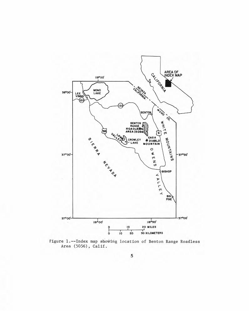
The 3enton Range Roadless Area covers about 17.5 Area. The geology of the area had been published previouslj2mi (45 km) or 11,200 acres at the south end of the Benton by Rinehart and Ross (1957) and Krauskopf and Bateman
Range, at the north end of Owens Valley, in T. 2 and 3 S., R. (1977), and geology of the roadless area was compiled from 31 E., Mount Diablo base line and meridian. The area is these maps and field checked in the summer of 1980 (McKee approximately 33 mi (53 km) southeast of Mono Lake, Calif., and Donahoe, 1981). At the same time, 11 rock samples and and 27 mi (43 km) north of Bishop (fig. 1). 12 stream-sediment and panned-concentrate samples were
There is easy access to the area from Benton Hot collected for evaluation by the U.S. Geological Survey. The Springs, located on State Highway 120 (fig. 2). The area can results were published in a geochemical map of the roadless be reached also from Bishop, by traveling 19 mi (30 km) north area (Donahoe and others, 1982). on U.S. Highway 6, then 10 mi (16 km) west on Red Rock Early mineral investigations of the Benton Range area Canyon Road. Jeep trails lead to most major mines from were done by Whiting (1888) and Boalich (1922). An U.S. Forest Service and county roads. investigation concerned specifically with tungsten was done
by Lem mon (1941). Investigations of individual mines in the Previous and present investigations nearby area have been done by Tucker (1934) and Rinehart
and Ross (1956). Geologic and geochemical investigations and a survey The U.S. Bureau of Mines conducted a detailed study
of mines and prospects have been conducted to evaluate the of mines and prospects in or near the roadless area. Records mineral resource potential of the Benton Range Roadless and publications from the U.S. Bureau of Mines, the U.S.
1
Geological Survey, and the California Division of Mines and Geology were examined for data related to mineral deposits in the study area. Mono County mining-claim records, U.S. Bureau of Land Management records, and U.S. Forest Service minerals files were also examined for claim information. Attempts were made to contact current claim owners. In the fall of 1980, 540 rock and 12 placer samples were taken by the U.S. Bureau of Mines.
GEOLOGY
The Benton Range is composed of about equal amounts of metamorphic, plutonic, and volcanic rocks. The southern part of the area consists mostly of metamorphic rocks that are part of a large pendant engulfed in granitic rocks of the Sierra Nevada batholith.
Metamorphic rocks
The metamorphic rocks are the oldest rocks in the range and are thought to be Paleozoic because of their lithologic similarity to Paleozoic rocks in the White Mountains and the Sierra Nevada. The most common rocks are quartz-muscovite (sericite) hornfels and phyllite, spotted graphite-andalusite hornfels, talc-silicate hornfels, and marble. Near contacts with granitic rocks, wide zones of marble and talc-silicate hornfels have been converted to skarn or tactite, characterized by garnet, epidote, idocrase, and diopside. Where skarns are developed but no granitic rock is exposed nearby, it is assumed that granite exists at a shallow depth beneath the skarn. The tactites locally contain small amounts of wollastonite, pyrite, molybdenite, and scheelite. Local concentrations of scheelite were mined in the past.
Plutonic rocks
Four granitic plutons are exposed in the Benton Range. The plutonic rocks constitute most of the northern part of the roadless area, but they also occur as isolated outcrops in metamorphic rocks in the southern part.
Granodiorite of the Benton Range
Outcrops of this pluton make up the central part of the Benton Range. The rock is a medium- to coarse-grained, locally porphyritic hornblende-biotite granodiorite. Phenocrysts, where present, are orthoclase; accessory minerals include magnetite, apatite, sphene, and allanite. The pluton contains many dark inclusions, mostly less than 2 in. (5 cm) long, abundant dikes, bodies of alaskite, aplite, and pegmatite. In most places, a very faint foliation is produced by alinement of inclusions and phenocrysts. This fabric is especially noticeable near contacts with metamorphic rocks. Potassium-argon radiometric dating yielded a Triassic age of 210 m.y. The granodiorite of the Benton Range is thus part of the oldest group of plutons of the Sierra Nevada batholih.
Small bodies of granitic rock as much as 0.6 mi (1 km2) in area composed mostly of alaskite occur in several places. The largest alaskite body is in the north-central region and intrudes the granodiorite of the Benton Range. Two smaller alaskite bodies intrude metamorphic rocks in the southern part of the area. The rock ranges from fine to coarse grained and is locally porphyritic or pegmatitic. Quartz is the most abundant mineral, with potassium feldspar and plagioclase occurring in subordinate amounts. Muscovite is almost always present, and sphene, apatite, pink garnet, allanite, and magnetite occur as accessory minerals. This unit is younger than the Triassic granodiorite of the Benton Range, which it intrudes, and is probably younger than the Jurassic granite of Casa Diablo Mountain.
Granite of Casa Diablo Mountain
The granite of Casa Diablo Mountain constitutes most of the northern part of the Benton Range Roadless Area and is exposed locally beneath a thin cover of Tertiary basalt. Most of this pluton is coarse-grained hypidiomorphic-granu]ar
granite composed of about 40 percent potassium feldspar and 30 percent each of quartz and plagioclase. Minor biotite is locally present and magnetite is a common accessory mineral. This granite typically crops out as hummocks formed by deep weathering along joints that cut the otherwise massive granite. A few small aplite and lamprophyre dikes and quartz veins randomly cut the pluton. Potassium-argon dating has yielded a Jurassic age of about 160 m.y. Plutons of approximately this age are abundant in and constitute a large proportion of the Sierra Nevada batholith.
Diorite and associated bodies
Diorite occurs at two localities in the study area. One is an isolated body in the south-central part of the area almost entirely surrounded by metamorphic rocks. The second locality, on the west side of the map area, is a group of outcrops whose contacts are unexposed. The unit includes rocks of basaltic and gabbroic composition and texture as well as a variety of dioritic types. Typically, these rocks are dark medium- to coarse-grained plagioclase-rich rocks with hornblende and, locally, pyroxene and olivine. Epidote, sphene, magnetite, and apatite are common accessory minerals. In the southern part of the Benton Range Roadless Area, dioritic rocks are bordered by tactite bodies formed by interaction with calcareous rocks. In general, the larger bodies of diorite have textures and mineral assemblages suggestive of assimilation of a variety of country rocks. The diorites are considered to be Jurassic and (or) Cretaceous in age, on the basis of intrusive relations in the Benton Range and nearby areas.
Volcanic and hypabyssal rocks
Dikes, sills, and small bodies of felsic composition are concentrated in a northerly trending swarm in the southwestern part of the Benton Range Roadless Area and adjacent areas to the west. This group of rocks, mostly dikes as much as 1.2 mi (2 km) long, intrudes all older units and has no apparent relation to preexisting geologic structures. The felsic rock is mostly rhyolite and is typically porphyritic, with phenocrysts of quartz, microcline, and sodic plagioclase in a dense aphanitic groundmass. These rocks are considered to be Cretaceous and (or) Tertiary in age.
Basalt flows crop out extensively in the northern part of the roadless area, where they lie mostly on the granite of Casa Diablo Mountain. The basalts are mostly thin lava flows with local scoriaceous zones. The rock is gray to black and contains phenocrysts of olivine and, commonly, plagioclase and pyroxene. The basalt is assigned a Pliocene age, but it may include rocks of Miocene age as well.
The Bishop Tuff, a very widespread rhyolite ash-flow tuff, crops out in the southernmost part of the study area. In the Benton Range, this unit is composed of weakly welded to nonwelded pink and white ash with abundant subangular pumice fragments. Phenocrysts of quartz, sanidine, and biotite occur in the tuff. The Bishop Tuff erupted from the Long Valley caldera a few miles west of the Benton Range about 0.7 m.y. ago (Dalrymple, 1980).
GEOCHEMICAL ANALYSES
Samples of rocks, stream sediments, and panned concentrates collected by the U.S. Geological Survey were analyzed for 31 elements using a six-step semiquantitative emission spectrographic method (Grimes and Marranzino, 1968). Because of the limited amount of sample, the nonmagnetic heavy-mineral concentrates were only analyzed spectrographically. All of the rock and stream-sediment samples were also analyzed for zinc by atomic-absorption spectrometry (Ward and others, 1969); some of these samples were analyzed for gold by the same technique (Meier, 1980). Stream-sediment samples were also analyzed for uranium using a modification of the fluorometric method of Centanni and others (1956). Results of the analyses and their geochemical interpretation are given by Donahoe and othei-s (1982).
2
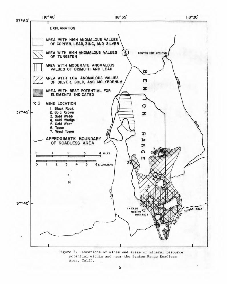
Rock samples collected by the U.S. Bureau of Mines were fire assayed for gold and silver; copper, lead, and zinc were analyzed by atomic absorption in some cases. Selected samples were analyzed for 42 elements by semiquantitative spectrographic methods; some samples were analyzed for other suspected metallic elements by atomic absorption, colorimetry, X-ray fluorescence, or radiometric techniques. Results of these analyses are summarized below in "Assessment of Mineral Resource Potential" and in figure 2.
MINING AND MINERALIZATION
The Benton Range Roadless Area lies entirely within the Chidago mining district. According to Mono County records, dating from 1865 to the present, 12 different mining-district names have been used for areas in or near the roadless area: Banner, Benton, Black Rock, Blind Spring Hill, Chidago, Clover Patch, Gold Ridge, Indian, Moran, Tower, Wild Rose, and Yellow Jacket.
The earliest mining was in the Blind Spring Hill area 3 mi (4.8 km) northeast of the roadless area (Rinehart and Ross, 1956). Between 1861 and 1888, this area produced about $3,945,869 of gold ore (Whiting, 1888). Development of the Tower mine east of the roadless area began in 1876 (Whiting, 1888), and by 1888 the mine had produced $150,000 of gold ore. In 1916, tungsten was discovered south of the Tower mine (outside of the roadless area) at what became the Black Rock mine in 1928 (Dupuy, 1948; Yih and Wang, 1979). By 1978, 700,000 tons (635,000 t) of tungsten ore had been produced at the Black Rock mine. A summary of production and assessment of the resource potential of mines in the study area is in table 1.
History of production
At least 685 mining claims have been located in the Benton Range Roadless Area since 1865; 661 are lode claims and 24 are placer claims. There are no patented claims. According to U.S. Bureau of Land Management records, 28 mining claims in the area were current in 1980. Mines with significant production or resources are shown in figure 2.
A total of 2,243 oz (70 kg) of gold, 8,450 oz (260 kg) of silver, and 4,600 lb (2,090 kg) of lead have been produced from mines within the roadless area. In addition, 7,257 oz (226 kg) of gold and 350 oz (11 kg) of silver were mined at the Tower mine and 700,000 tons (635,000 t) of tungsten ore was mined at the Black Rock mine, both outside of the roadless area.
The Gold Crown mine was first developed in the 1870's as the Neal mine. Major development on the property took place between 1936 and 1941. During that period, at least 4,878 tons (4,400 t) of ore yielded about 2,019 oz (62.8 kg) of gold and 3,293 oz (102 kg) of silver (U.S. Bureau of Mines files); average grade was 0.41 oz gold per ton (14.0 g/t) and 0.68 oz silver per ton (23.3 g/t).
In 1882, the Rose of the West claim was filed and subsequently became known as the Gold Webb mine. By 1939, from the Gold Webb mine, 371 tons (336 t) of ore, averaging 0.41 oz gold per ton (14.0 g/t), 2.67 oz silver per ton (91.5 g/t), and 0.62 percent lead, had been shipped from the Gold Webb mine (U.S. Bureau of Mines files).
By 1927, 84 tons of ore, averaging 50 oz of silver per ton (1.7 kg/t) and 0.4 oz of gold per ton (13.7 g/t), were produced at the Gold Wedge mine.
The West Tower mine was explored in the 1880's for silver, but claimed for tungsten in the 1930's. U.S. Bureau of Mines records indicate that 60 lb (27.2 kg) of concentrate with 66.7 percent tungsten trioxide (W03) were shipped in 1956.
Mineral deposits
Native gold and gold in sulfide minerals occur principally in quartz veins and associated shear zones. Silver minerals also may be present in these deposits. Tactite, formed at the contact between intrusive and calcareous sedimentary and metasedimentary rocks, locally contains scheelite (calcium tungstate). Lead, zinc, and copper occur
in some of the quartz veins and tactite deposits. Numerous porphyritic rhyolite dikes as much as 30 ft
(9 m) thick occur near the Gold Crown mine. These are associated with quartz veins, some of which locally replace the entire dike. The gold and silver minerals are principally in the quartz and disseminated in the adjacent metamorphic country rocks. Gold- and silver-bearing minerals occur in quartz-rich shear zones at the Gold Webb and Gold Wedge mines but just outside the roadless area.
At the Black Rock mine (outside the roadless area) tungsten resources occur in tactite bodies primarily along the crest and west limb of a northward-plunging anticline in metasedimentary rocks; tungsten resources may extend into the roadless area along this structure.
ASSESSMENT OF MINERAL RESOURCE POTENTIAL
Three areas within the Benton Range Roadless Area have indications of mineral potential on the basis of geologic features, geochemical sampling, and evaluation of existing mines and prospects (fig. 2). (1) The southern part of the roadless area, near which all of the existing mines occur, is geologically favorable for tungsten, gold, and silver mineralization. Anomalous amounts of tungsten were found in panned-concentrate samples. Other elements, including boron, bismuth, and strontium, are also present in anomalous concentrations in these contact-metamorphosed rocks. (2) The central part of the roadless area (fig. 2) contains fairly large estimated resources of gold and silver in quartz veins. About 190,000 tons (172,000 t) of subeconomic gold and silver resources are estimated to be in the roadless area. (3) Several drainages in the northwestern part of the roadless area show strong anomalies of copper, lead, zinc, and silver in stream-sediment and panned-concentrate geochemical samples. This suite of elements suggests that hydrothermal alteration was the source of mineralization and that the metallic elements may come from the quartz and (or) diorite dikes that intrude the granitic rocks of the area. Small but rich deposits of lead-zinc-silver are a reasonable target for exploration in this area.
REFERENCES
Boalich, E. S., 1922, San Francisco Field Division: California State Mining Bureau, Mining in California, v. 18, no. 9, p. 413-419.
Centanni, F. A., Ross, A. M., and DeSesa, M. A., 1956, Fluorometric determination of uranium: Analytical Chemistry, v. 28, no. 11, p. 1651-1657.
Dalrymple, G. B., 1980, K-Ar age of the Friant Pumice Member of the Turlock Lake Formation, the Bishop Tuff, and the tuff of Reds Meadow, central California: Isochron/West, no. 28, p. 3-6.
Donahoe, J. L., Chaffee, M. A., Fey, D. L., Hill, R. H., and Sutley, S. J., 1982, Geochemical map showing anomalous drainage basins, Benton Range Further Planning (RARE Area, Mono County, California: U.S. Geological Survey Miscellaneous Field Studies Map MF-1317-B, scale 1:62,500.
Dupuy, L. W., 1948, Black Rock tungsten deposit, Mono County, California: U.S. Bureau of Mines Report of Investigations 4210, 6 p.
Grimes, D. J., and Marranzino, A. P., 1968, Direct-current arc and alternating-current spark emission spectrographic field methods for the semiquantitative analysis of geologic materials: U.S. Geological Survey Circular 591, 6 p.
Krauskopf, K. B., and Bateman, P. C., 1977, Geologic map of the Glass Mountain quadrangle , Mono County, California, and Mineral County, Nevada: U.S. Geological Survey Geologic Quadrangle Map GQ-1099, scale 1:62,500.
Lemmon, D. M., 1941, Tungsten deposits of the Benton Range, Mono County, California: U.S. Geological Survey Bulletin 922-S, p. 581-593.
McKee, E. H., and Donahoe, J. L., 1981, Geologic map of the Benton Range Further Planning (RARE II) area, Mono County, California: U.S. Geological Survey
3

Miscellaneous Field Studies Map MF-1317-A, scale 1:62,500.
Meier, A. L., 1980, Flameless atomic-absorption determination of gold in geological materials: Journal of Geochemical Exploration, v. 13, no. 1, p. 77-85.
Rinehart, C. D., and Ross, D. C., 1956, Economic geology of the Casa Diablo Mountain quadrangle, California: California Natural Division of Mines Special Report 48, 17 p.
1957 Geology of the Casa Diablo Mountain quadrangle, California: U.S. Geological Survey Geologic Quadrangle Map GQ-99, scale 1:62,500.
Tucker, W. B., 1934, Current mining activity in southern California: California Journal of Mines and Geology, v. 30, no. 4, p. 310-327.
Ward, F. N., Nakagawa, H. M., Harms, T. F., and VanSickle, G. H., 1969, Atomic-absorption methods of analysis useful in geochemical exploration: U.S. Geological Survey Bulletin 1289, 45 p.
Whiting, H. A., 1888, Benton mining district, Mono County, California: California Mining Bureau Report 8, p. 376-382.
Yih, S. W. H., and Wang, C. T., 1979, Tungsten sources, metallurgy, properties, and applications: New York, Plenum Press, 500 p.
4
AREA OF INDEX MAP-VII9°001
0
38°001-
0 • OeN
BENTON RANGE •
ROA OLE**. AREA (5056)N 6
tS) '4( 4,
4'). LAKE
CROWLEY CAS
ABAD IL O /c.6 MOUNTAIN
0 9 7
37°301- -37°30'
N "t•
<(‘
• BISHOP0 4
BIG PINE \
37°Od 37°00'
nood I18°30'
10 20 MILES
0 10 20 30 KILOMETERS
Figure 1.--Index map shoN;Ting location of Benton Range Roadless Area (5056), Calif.
5
118° 40' 118°35' 118°30' 37° 50'
EXPLANATION
AREA WITH HIGH ANOMALOUS VALUES OF COPPER, LEAD, ZINC, AND SILVER
AREA WITH HIGH ANOMALOUS VALUES OF TUNGSTEN
BENTON HOT SPRINGS •
AREA WITH MODERATE ANOMALOUS VALUES OF BISMUTH AND LEAD
AREA WITH LOW ANOMALOUS VALUES OF SILVER, GOLD, AND MOLYBDENUM
0
AREA WITH BEST POTENTIAL FOR ELEMENTS INDICATED
37°45'
3 MINE LOCATION I. Black Rock 2. Gold Crown 3. Gold Webb 4. Gold Wedge 5. Gold West 6. Tower 7. West Tower
APPROXIMATE BOUNDARY OF ROADLESS AREA
0
0 2 3 4 MILES
0 I 2 3 4 5 6 KILOMETERS
37°40'
z 0 0
ROAD
Figure 2.--Locations of mines and areas of mineral resource potential within and near the Benton Range Roadless Area, Calif.
6

Table 1.--Mines, prospects, and mineralized areas in the Benton Range Roadless Area (5056), California [Underlined name indicates that the mine or prospect is outside of the study area; map numbers
refer to figure 2]
Map Name
number (Commodity) Summary
1. Black Rock mine Tactite bodies are along the contact (tungsten) of a Cretaceous granitic intrusive
body and older calcareous sedimentary rocks. Tactite containing scattered scheelite is found along the west limb of a northward-plunging anticline.
2. Gold Crown mine Northward-striking shear zone (gold, silver)
3. Gold Webb mine (Johnnie King) (gold, silver)
intermittently exposed for 2,100 ft (640 m) and as much as 50 ft (15 m) wide. This zone contains quartz and rhyolite dikes striking N. to N. 15° E. and dipping 70° NW. to 75° SE.
Pyrite and galena are concentrated in a 3.5-ft (1.0-m) shear zone striking N. 55° E. and dipping 35° to 55° NW. in hornfels. Very little quartz is in the shear zone, which is exposed discontinuously for 1,000 ft (300 m).
4. Gold Wedge mine North- and east-striking steeply (gold, silver) dipping quartz veins in hornfels.
The veins are as thick as 4.0 ft (1.2 m) and are exposed as much as 140 ft (43 m) downdip. Sulfides, primarily pyrite, occur as irregularly spaced pods in the quartz.
Workings and production
There are 33,000 ft (10,000 m) of underground workings. From 1928 to 1978 approximately 700,000 tons (635,000 t) of tungsten ore averaging 0.5 percent W03 have been mined.
Five edits (three of which are caved) and four shafts are on the property. Two of the caved edits are accessible through a shaft and have combined workings of 650 ft (198 m). Records show that 2,019 oz (62.8 kg) gold and 3,293 oz (102.42 kg) silver have been produced.
Four adits, three shafts, and several trenches and pits are along the shear zone. Adits total 1,040 ft (317 m) of workings. Three hundred seventy-one tons (336 t) of ore averaging 0.41 oz gold per ton (14 g/t) and 2.67 oz silver per ton (91.5 g/t) were shipped.
Four shafts, three adits, and several pits and trenches have a combined length of 1,100 ft (335 m). Eighty-four tons (76.2 t) of ore averaging 0.4 oz gold per ton (13.7 g/t) and 50 oz silver per ton (1.71 kg/t) were shipped.
5. Gold West mine Shear zone 15 ft (4.6 m) wide striking Four pits about 10 by 15 ft (gold) N. 10° W. and dipping vertically is
between rhyolite and hornfels.
6. Tower mine Quartz vein varying from 2 to 4 ft (gold, silver) (0.6 to 1.2 m) in thickness striking
N. 10° E. and dipping 80° W., occurs in granodiorite. Ore occurs in the vein as irregular bunches or kidneys of rich argentiferous pyrite in quartz. Associated minerals are sphalerite, pyrite, galena, pyragyrite, and other antimonial silver minerals.
7. West Tower mine A 100- by 150-ft (30- by 45-m) body (tungsten) of siliceous epidote-garnet-
actinolite tactite is in calc-hornfels.
(3 by 4.6 m), a 45-ft (13.7-m) bulldozer trench, and a 23-ft (7-m) shaft.
The Tower mine has five shafts and three edits. The south shaft is reported to be 190 ft (58 m) deep and the north shaft 280 ft (85 m) deep. The shafts are inaccessible. By 1888, $150,000 worth of bullion had been shipped from the south shaft.
A shaft 26 ft (7.9 m) deep and a bulldozer cut 60 by 90 ft (18 by 27 m) are on the property. In 1956, 60 lb (27.2 kg) of 66.7 percent W03 concentrates were shipped.
Assessment of
resource or potential
Presence of resource could not be determined, but tungsten resources probably extend into the roadless area.
Approximately 110,000 tons (100,000 t) of subeconomic resources with an average grade of 0.078 oz gold per ton (2.67 g/t) are in the shear zone on the property.
Approximately 58,000 tons (53,000 t) of subeconomic resources averaging 0.028 oz gold per ton (0.96 g/t) and 0.40 oz silver per ton (13.7 g/t).
About 34,000 tons (31,000 t) of subeconomic resources that average 0.026 oz gold per ton (0.89 g/t) and 2.6 oz silver per ton (89.1 g/t) are estimated in the Gold Wedge mine area. Of this, about, 30,000 tons (22,000 t) averaging 0.026 oz gold per ton (0.89 g/t) and 2.6 oz silver per ton (89.1 g/t) are inside the roadless area.
Seven grab samples assayed from trace to 0.135 oz gold per ton (4.63 g/t) and one grab sample of quartz contained 1.0 oz gold per ton (34.3 g/t). Three chip samples of quartz contained from 0.022 to 0.157 oz gold per ton (0.75 to 5.38 g/t). This claim has a moderate potential for the discovery of gold resources.
Approximately 400 tons (360 t) of subeconomic resources with an average grade of 1.1 oz silver per ton (37.7 g/t) are at the south shaft. The dump at the south shaft contains a subeconomic resource of 37,000 tons (33,566 t) with an average grade of 0.007 oz gold per ton (0.24 g/t) and 3.0 oz silver per ton (102.86 g/t). Ten thousand tons (9,072 t) of subeconomic resources with a grade of 0.015 oz gold per ton (0.51 g/t) and 0.32 oz silver per ton (10.97 g/t) are in the dump at the north shaft.
Approximately 22 tons (20 t) of subeconomic ore with an average grade of 0.42 percent W03 are in the dump near the shaft. The tactite body has about 5,700 tons (5,170 t) of 0.06 percent WO3 and a minor amount of gold. A moderate potential for discovery of more tungsten exists.
7
