military deployment coordination (interim guide) · interim guide – june 2002 1 military...
TRANSCRIPT

Interim Guide – June 2002 1
Military Deployment Military Deployment
Coordination Coordination
Procedures Guide Procedures Guide
for State Agencies for State Agencies
(Interim Guide) (Interim Guide)
June 10, 2002
Military Deployment Military Deployment
Coordination Coordination
Procedures Guide Procedures Guide
for State Agencies for State Agencies
(Interim Guide) (Interim Guide)
June 2002

Interim Guide – June 2002 2
INTRODUCTION AND PURPOSE OF THE GUIDE During the past several years, the Federal Highway Administration (FHWA) has been working closely with the Military Traffic Management Command Transportation Engineering Agency (MTMCTEA) in an initiative to support military mobilization. The principal objective of this initiative is to ensure States have adequate coordination procedures to support military deployments while, at the same time, managing civilian traffic during national security emergencies. A successful set of coordination procedures or plans will ensure the highway system operates effectively to meet military deployment or movement needs and is not a major impediment or bottleneck. Purpose of the Guide The purpose of the guide is to assist states in developing and/or updating their emergency operations plans or Emergency Highway Transportation Regulations (EHTR) Plans, where applicable. The guide provides useful information regarding military deployment concepts, State/local roles and responsibilities, recommended coordination procedures, and a number of special considerations such as communications, Intelligent Transportation System (ITS) technologies, and force protection. The guide offers “generic” procedures for States to adopt in whole or in part when revising their existing emergency operations plans. Moreover, while the focus of this guide is military deployments (forts to ports), the information may also assist state agencies in preparing for and coordinating requirements during other national security events and emergency situations. Typical Users of This Guide This guide is written primarily for those government officials who are tasked with the development, coordination, implementation, and maintenance of the state’s transportation emergency operations plan. This person may be an emergency response coordinator, a traffic operations engineer or planner, or security specialist. The guide also contains information applicable to other functions and activities, such as permitting, traffic engineering, incident management, ITS planning and operations, law enforcement, etc. Individuals with these skills should be consulted during the development of a set of coordination procedures or plans. While the guide is applicable to all states (“generic”), certain states have critical military installations and/or seaports of embarkation that necessitate a higher degree of coordination between state agencies and military installations. Consequently, the Emergency Response Coordinator (assumed hereafter to be the person tasked with procedures or plan development) will need to involve the appropriate military agencies, port organizations, and other agencies, as appropriate. These additional agencies might include, as examples, departments of public safety, offices of emergency management, and the National Guard. How to Use this Guide The Emergency Response Coordinator should use this guide to understand the basic facts and procedures associated with military convoy movements, to develop or update a set of State procedures or plans, and to be aware of and address special circumstances or conditions. Some of these steps will require interaction, discussions, and concurrence with other agencies

Interim Guide – June 2002 3
and organizations. The final approval and dissemination of the coordination procedures or plans will necessarily follow state agency policies. Organization of This Guide The main body of the guide describes key agency responsibilities and relationships, essential convoy activities, and recommended coordination procedures to ensure successful updates to existing plans. A section on special considerations and the appendices offer extensive background information and references. This guide is designed to serve as a quick reference document for state agencies that have a role when convoys may travel on public roads. It is also designed to encourage these agencies to compare their current plans with the guide to improve their preparedness in the event that major deployments or national security emergencies occur. Chapter One provides a general overview of the changing global nature of the military mission and the need for rapid military deployments. Chapter Two is an overview of the roles of the six key agencies and organizations that have a significant function or responsibility in military deployments. Chapter Three offers typical activities and considerations to prepare for and implement a major deployment and convoy movement. A special section of Chapter Three discusses special situations that may require additional coordination and response efforts, namely rerouting a convoy, incident management, equipment failure, and convoy security. Chapter Three concludes with a series of questions that agencies should use to self-assess their procedures in advance of the actual convoy movement. While the self-assessment questions may not be universal for every situation or every state, they are provided as a checklist to assist state agencies in asking pertinent questions of themselves and others to assist with their plan refinements. Chapter Four presents a five-step framework for developing or updating a set of procedures or plans. Chapter Five contains a more detailed examination of circumstances that are more challenging and provides potential options for mitigation. These areas include current concepts of force protection, telecommunication interoperability issues, current and future technology enhancements, and ITS that could be used during military emergencies or similar events for traffic operations. The appendices include a section of key terms, acronyms and references. In addition, a more detailed section describes how the military typically organizes their convoys and how they operate on the roadway. This information will allow state agencies to better understand how the military intends to perform their mission. There is also a matrix listing a number of the military installations that are considered to be the main source of equipment (Power Projection Platforms – PPP) should the United States engage in a large military operation. The matrix lists the states in which the PPP are located and the commercial seaports that may be used if military operations were to occur outside of the borders of the United States. Evolution of the Interim Guide This first version of the interim guide is based on a review of the literature, guidance manuals, key interviews, and a tabletop exercise conducted in March 2002 for the state of Texas. At the tabletop exercise, more than 50 individuals discussed basic procedures for Texas military movements as well as special scenarios to highlight coordination procedures and issues, especially agency roles and resources. Tabletop participants included the Department of Transportation (emergency operations, structures, traffic operations, permits, ITS specialists), public safety agencies (Highway Patrol, local law enforcement, FBI), emergency management

Interim Guide – June 2002 4
functions (State and regional coordinators), as well as military transportation experts, the Defense Movement Coordinator, and various commercial port and transport operators. A series of similar research techniques and tabletop exercises will be conducted in other states during CY2002-2003 to assist in the refinement of this interim guide.

Interim Guide – June 2002 5
Table of Contents
INTRODUCTION AND PURPOSE OF THE GUIDE 2
1.0 INTRODUCTION TO CURRENT MILITARY DEPLOYMENT CONCEPTS 8
1.1 Current Military Deployment Strategy 8
1.2 Federal and Military Threat Levels and Advisory Systems 9
1.3 Deployment Coordination and Communication 10
2.0 ROLES AND RESPONSIBILITIES OF KEY STATE AND LOCAL AGENCIES DURING MILITARY DEPLOYMENTS 11
2.1 State Department Of Transportation (SDOT) 12
2.2 State Department Of Public Safety (DPS) and Law Enforcement Agencies 13
2.3 Emergency Management 14
2.4 State Defense Movement Coordinator 15
2.5 Military Deploying Installation Offices 15
2.6 Commercial Seaports of Embarkation (Or Other Destinations) 17
3.0 TYPICAL MILITARY DEPLOYMENT MOVEMENTS ON PUBLIC ROADS 19
3.1 Military Road Deployment Concepts 20
3.2 Major Phases of a Typical Military Deployment 22
3.3 State Agency Checklists For Typical Military Deployments 27
4.0 RECOMMENDED COORDINATION PROCEDURES 32
4.1 Developing Coordination Procedures 32
4.2 Action Steps for Developing Coordination Procedures or Plans 32
5.0 SPECIAL CONSIDERATIONS 42
5.1 Communication Systems and Technology 42
5.2 Role of ITS Technologies 44

Interim Guide – June 2002 6
5.3 Emergency Operations Centers (EOCs) 49
5.4 Force Protection 52
A. KEY TERMS 53
B. ACRONYMS 58
C. LIST OF POWER PROJECTION PLATFORMS 62
D. REFERENCES 64
E. MILITARY CONVOY MOVEMENT FACTS 68
F. FEEDBACK FORM 78 Figures Figure 1-1 A Comparison of the Current Federal Alert System and the Military’s THREATCON System 9 Figure 1-2 Key Military Convoy Planning and Implementation Agencies. _______________________ 10 Figure 2-1 Effective Coordination Procedures or Plans Require a Collaborative Effort Among Six Key Agencies. __________________________________________________________________________ 11 Figure 2-2 State DOTs Have New ITS Options to Assist Highway Operations ____________________ 12 Figure 2-3 Example of a Heavy Equipment Transport System (HETS) Vehicle in action. ____________ 13 Figure 2-4 After arriving at the seaport, the equipment, such as this truck, is loaded onto Military Sealift Command (MSC) ships for overseas movement ____________________________________________ 18 Figure 3-1. Factors Affecting Well Coordinated and Executed Military Deployments. _____________ 19 Figure 3-2 Weather Conditions Affect Military Deployments, Which May Inhibit General Traffic Operations. ________________________________________________________________________ 22 Figure 3-3 Key Agency Roles During the Warning Order Phase. ______________________________ 23 Figure 3-4 Key Agency Roles When the Notice to Deploy is Received. __________________________ 24 Figure 3-5 State DOTs Use Carefully Delineated Procedures to Ensure That the Highway Network is Able to Support the Convoy Deployment Route. ____________________________________________ 25 Figure 3-6 Key Agency Roles During Deployments _________________________________________ 26 Figure 3-7 Special Traffic Control Devices May be Needed During Convoy Movements. ___________ 27 Figure 3-8 State Agency Checklist Part One. ______________________________________________ 29 Figure 3-9 State Agency Checklist Part Two. ______________________________________________ 30 Figure 3-10 State Agency Checklist Part Three.____________________________________________ 31 Figure 4-1 A Five-step Process is Proposed for Developing Coordination Procedures._____________ 33 Figure 4-2 A range of Organizational Structures may be used to develop Coordination Procedures. __ 34 Figure 4-3 Summary checklist for Step 1 – Getting Started.___________________________________ 35 Figure 4-4 Summary checklist for Step 2 – Gather Data/Identify Needs._________________________ 36 Figure 4-5 Key Coordination and interaction points are illustrated by dotted and solid lines. The State DOT representative needs to coordinate closely with the DMC, EM, and Law Enforcement communities to ensure traffic planning and operations support military deployment needs. ____________________ 38 Figure 4-6 Summary checklist for Step 3 – Define Agency Interaction and Preliminary Procedures or Plan. _____________________________________________________________________________ 40

Interim Guide – June 2002 7
Figure 5-1 Portable Traffic Control Devices can assist with Work Zone Activities. ________________ 44 Figure 5-2 ITS Technologies That May Support Military Deployments _________________________ 46 Figure 5-3 Traffic Management Centers such as TranStar in Houston, Texas give a live view of current weather and traffic conditions. These views can be accessed by all agencies through the Internet.____ 47

Interim Guide – June 2002 8
1.0 INTRODUCTION TO CURRENT MILITARY DEPLOYMENT
CONCEPTS 1.1 Current Military Deployment Strategy America's military has changed significantly to meet the challenges of our uncertain world. An understanding of the evolving international environment, the national security strategy, and the capabilities required for full spectrum dominance have guided the military's transformation from a Cold War, forward-deployed force to a capabilities-based, power projection force located largely in the United States. The military has reduced its size, redistributed its forces, closed and realigned bases, reorganized its equipment pre-positioned overseas, and rapidly improved active and reserve component integration to become leaner, more versatile, and more deployable. Strategic mobility and readiness is the key to the military's ability to project power. Each of the military services (Army, Navy, Air Force, and Marine Corps, as well as their National Guard and Coast Guard counterparts) has made great strides in implementing the specific recommendations of the January 2001, congressionally mandated, Mobility Requirements Study. The military's goal is to project the following forces1 rapidly to anywhere in the world.
• A light brigade in four days (3,500 personnel) • A heavy brigade afloat in 15 days (5,000 personnel) • A light division in 12 days (10,000 personnel) • Two heavy divisions in 30 days (30,000 personnel) • A five-division contingency corps in 75 days (65,000 personnel)
Of these forces, a light brigade and a light division would typically be deployed by air through Aerial Ports of Embarkation (APOE). The remaining forces would be deployed by sealift through a Seaport of Embarkation (SPOE). Movements by sea would require a large number of vehicles and equipment to move from a military installation to a SPOE by either railcar or by convoys on public roads. Moreover, the volume and designated routes may change based on various factors, including urgency, security and threat levels, types of equipment to be moved, and the availability of transportation assets. A substantial amount of scenario-based planning and contingency considerations has been used to develop robust procedures for a multi-modal, time-phased deployment of military assets. Consequently, requests for military deployments represent a critical link in a complex chain of events in fulfilling the overall military mission.
1 The exact quantities of equipment to be moved to meet these goals is considered to be classified or restricted information. In general, a large-scale deployment of military forces would require thousands of vehicles to depart from multiple installations. The Federation of American Scientists (FAS) maintains public information of this type under a section titled DOD 101 at the following URL: www.fas.org. The user of the guide should note this reference is primarily for conveying the general magnitude and scale of military movements.

Interim Guide – June 2002 9
Military units employ a variety of methods to move their equipment and personnel to seaports. The bulk of the heavy equipment will be shipped by rail. However, some equipment will need to deploy on public roads to arrive at the seaport to be loaded at specific dates and times onto ships. When the military uses a public road, they will organize their equipment into convoys for control and protection. Detailed information about how the military organizes convoys, as well as their standard highway procedures, can be found in Appendix E.
While the State Department of Transportation (SDOT) is primarily responsible for the planning, operations, and maintenance of the public roadways, the State Department of Public Safety works with the transportation agencies (state, city, local) to maintain and enforce public safety on the roadways. Under certain circumstances of a military deployment, the public safety agencies may assist through normal procedures and protocols. However, under special circumstances or specific military requests, enhanced assistance from the Departments of Transportation and Public Safety may be needed. These special circumstances are discussed in greater detail in Chapters 3 and 5. 1.2 Federal and Military Threat Levels and Advisory Systems There are many federal alert systems in our country -- each tailored and unique to different sectors of our society: transportation, defense, agriculture, and weather, for example. These alert systems fill vital and specific requirements for a variety of situations in both the commercial and government sectors. The Homeland Security Advisory System (HSAS) provides a national framework for these systems, allowing government officials and citizens to communicate the nature and degree of terrorist threats. This advisory system characterizes appropriate levels of vigilance, preparedness and readiness in a series of graduated Threat Conditions (THREATCONs). The protective measures that correspond to each THREATCON will help the government and citizens decide what action to take to help counter and respond to terrorist activity.
Figure 1-1 A Comparison of the Current Federal Alert System and the Military’s THREATCON System
Green Blue Yellow Orange Red
Refine and exercise preplanned
protective measures (PMs)
Check communications with
designated emergency locations
Increase surveillance of critical locations
Coordinate necessary security efforts with armed
forces or law enforcement
agencies
Assign emergency response personnel
and pre-position specially trained
teams
Ensure personnel receive training on HSAS and agency-specific protective
measures
Review and update emergency response
procedures
Coordinate emergency plans
with nearby jurisdictions
Take additional precautiion at public
events
Monitor, redirect or constrain
transportation systems
Assess facilities regularly for
vulnerabilities and take measures to
reduce them
Provide the public with necessary
information
Assess protective measures within the
context of current threat information
Prepare to work at an alternate site or with
a dispersed workforce
Close public and governemnt facilities
Implement, as appropriate,
contingency and emergency response
plans
Restrict access to essential personnel
only
Increase or redirect personnel to address
critical emergency needs
Standard military facility operations
Possible danger to facilities and
personnel
Increase visibility of security personnel
Facility security forces on a high
state of alert
Localized area of highest security where attack has
occurred or is extremely probable
Limited noticeable effect to normal
operations
Access to facilities may be restricted to
authorized personnel
Avoid such areas unless absolutely
necessary
May be the default level of facility
security
Close inspection of credentials will be
required
Normal Alpha Bravo Charlie Delta
Increasing Severity
Seve
re
Fede
ral A
lert
Sys
tem
Mili
tary
Thr
eat C
ondi
tion
Low
Gua
rded
Elev
ated
Hig
h
Interim Guide – June 2002 10
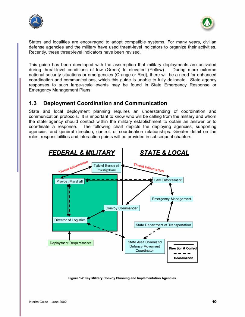
States and localities are encouraged to adopt compatible systems. For many years, civilian defense agencies and the military have used threat-level indicators to organize their activities. Recently, these threat-level indicators have been revised. This guide has been developed with the assumption that military deployments are activated during threat-level conditions of low (Green) to elevated (Yellow). During more extreme national security situations or emergencies (Orange or Red), there will be a need for enhanced coordination and communications, which this guide is unable to fully delineate. State agency responses to such large-scale events may be found in State Emergency Response or Emergency Management Plans. 1.3 Deployment Coordination and Communication State and local deployment planning requires an understanding of coordination and communication protocols. It is important to know who will be calling from the military and whom the state agency should contact within the military establishment to obtain an answer or to coordinate a response. The following chart depicts the deploying agencies, supporting agencies, and general direction, control, or coordination relationships. Greater detail on the roles, responsibilities and interaction points will be provided in subsequent chapters.
Figure 1-2 Key Military Convoy Planning and Implementation Agencies.
Law Enforcement
Emergency Management
State Area CommandDefense Movement
Coordinator
STATE & LOCALFEDERAL & MILITARY
Director of Logistics
Convoy Commander
Deployment RequirementsDirection & Control
Coordination
Threat InformationThreat Information
State Department of Transportation
Provost Marshall
Federal Bureau of Investigations
Interim Guide – June 2002 11
2.0 ROLES AND RESPONSIBILITIES OF KEY STATE AND LOCAL
AGENCIES DURING MILITARY DEPLOYMENTS Many agencies outside of the formal military structure play a critical role in ensuring the military deploys safely and efficiently with minimal impact to traditional highway traffic. The roles and responsibilities of those state agencies that assist in this mission are described in this section. The roles and responsibilities span multiple agencies, require inter-agency coordination and partnering, and include activities such as:
• Supporting normal agency functions even though military convoys may be deployed; • Responding to special requests for traffic management and control; • Augmenting traffic operations during special circumstances by providing additional
agency resources and personnel; • Increasing agency responsiveness and special roles during periods of heightened
security or critical need; and • Contributing to the maintenance and/or restoration of public order and services
associated with military deployments during emergencies.
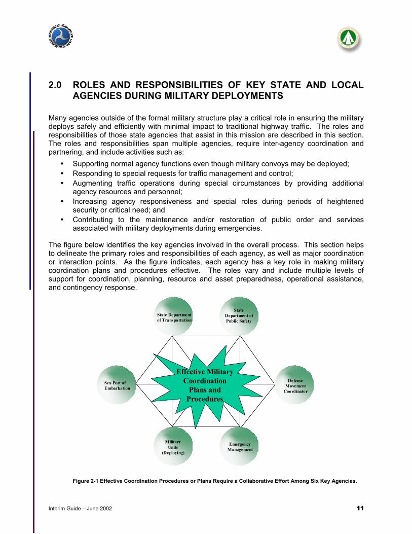
The figure below identifies the key agencies involved in the overall process. This section helps to delineate the primary roles and responsibilities of each agency, as well as major coordination or interaction points. As the figure indicates, each agency has a key role in making military coordination plans and procedures effective. The roles vary and include multiple levels of support for coordination, planning, resource and asset preparedness, operational assistance, and contingency response.
Figure 2-1 Effective Coordination Procedures or Plans Require a Collaborative Effort Among Six Key Agencies.
Sea Port of Embarkation
Military Units
(Deploying)
Emergency Management
Defense Movement
Coordinator
State Department of Transportation
State Department of Public Safety
Effective Military Coordination
Plans and Procedures
Sea Port of Embarkation
Military Units
(Deploying)
Emergency Management
Defense Movement
Coordinator
State Department of Transportation
State Department of Public Safety
Effective Military Coordination
Plans and Procedures

Interim Guide – June 2002 12
2.1 State Department Of Transportation (SDOT) In general, the SDOT ensures highway operations are available to meet public and military needs in the event of a national security emergency. In order to accomplish this, SDOT offices coordinate with both the Federal Highway Administration (FHWA) and military transportation organizations such as the Military Traffic Management Command Transportation Engineering Agency (MTMCTEA) to receive guidance and policy to ensure that state transportation programs are addressing current requirements for civilian and military needs.2 While the emphasis in this subsection is on State DOTs, similar functions may need to be performed by city and local transportation agencies, depending on a region or state’s jurisdictional responsibilities for the public road network. During a national security emergency involving a military deployment, the SDOT plays a primary role by ensuring the desired routes are passable for the types of equipment and volumes, as well as issuing the correct permits to the military for vehicles that are using the State roadway system. Since some military vehicles are oversize and overweight by standard traffic engineering definitions, it is critical the SDOT assists in determining which routes (roads and bridges) will be able to support the equipment. The DOT permit officer must coordinate closely with regional and district DOT offices to ensure that height and weight clearance information is timely and accurate for every area through which a convoy may pass3. Convoy permit requests are sent to SDOTs by the State Defense Movement Coordinator (DMC) (see Section 2.4).
Figure 2-2 State DOTs Have New ITS Options to Assist Highway Operations
2 While the emphasis in this subsection is on State DOTs, similar functions may need to be performed by city and local transportation agencies, depending on a region or state’s jurisdictional responsibilities for the public road network. 3For instance, large military vehicles designed to transport battle tanks are known as Heavy Equipment Transport Systems (HETS). (See Figure 2-3.) When vehicles such as these are loaded, the clearance required may exceed 17’2” while standard clearance on highways is 16’.

Interim Guide – June 2002 13
SDOT offices provide additional support to military convoy movements by providing operational information to the DMC about special traffic advisories, construction work zones restrictions or closures, conditions at public rest areas/rest stop/refueling locations, incidents that may affect convoy timeliness, and the locations and time of recurring traffic congestion. The permit officer (or designee) must also be available throughout a convoy deployment in the event new or revised permits for oversize/overweight vehicles are needed because an approved route becomes impassable. SDOT Traffic Engineers assess and monitor traffic capacity and operations on designated or preferred deployment routes. Through traffic monitoring techniques and estimates of military vehicular volumes, the traffic operation specialists are able to ensure military needs are met without disrupting general civilian traffic. Many different ITS devices including Traffic Management Centers (TMCs) may be utilized to assist in monitoring traffic conditions and conveying critical and timely information to both military and civilian drivers. A more detailed discussion of ITS technologies is presented in Chapter Five.
Figure 2-3 Example of a Heavy Equipment Transport System (HETS) Vehicle in action.
2.2 State Department Of Public Safety (DPS) and Law Enforcement
Agencies The objective of the State DPS and law enforcement agencies is to ensure public safety. If any situation involving a military convoy occurred outside of the military installation, the State DPS would respond in the same manner as they do for any situation. As the State DPS is often called upon to support routine military convoy movements, they also play a critical support role during a national security emergency. Usually State and Local Law Enforcement Agencies are not manned or equipped to provide convoy protection against possible terrorist attacks. Under these extreme circumstances of public safety, assistance from federal agencies (FBI, Bureau of

Interim Guide – June 2002 14
Alcohol Tobacco and Firearms (ATF), etc.) may be needed and State and Local Law Enforcement may be called upon for added assistance. 2.2.1 State Law Enforcement The primary mission of State Police during a military deployment is the same as their every day mission: to enforce safe driving rules and traffic regulations on the highways. Additional supporting roles for State Police during military deployments are:
• Ensuring the convoys are not creating a safety hazard to civilian traffic or themselves due to unsafe practices;
• Providing convoy movement control when requested by the military, such as convoy escort through congested areas or around hazards, as well as traffic signal controls for improved pass through;
• Coordinating with State or regional DOT Operations Centers (as available); • Providing convoy accident or incident assistance; • Assisting with public relations and public information; • Providing reroute or detour recommendations; and • Relaying communications between the convoy commanders and their military movement
control centers through state, regional or local law enforcement dispatch centers. 2.2.2 Local Law Enforcement Local law enforcement agencies provide similar support to convoys as State Police within their jurisdictions. They may provide convoy movement control when requested by the military, such as convoy escort through congested areas. They may also assist in intersection clearance or synchronized traffic control and respond to accidents or incidents that involve convoys. Local law enforcement is often a critical communication link if information needs to be relayed between the convoy commanders in the field and the installation Provost Marshal Office. 2.3 Emergency Management State, regional and local Emergency Management agencies are responsible for supporting the activities of emergency responders. That support may be providing resources (equipment, supplies, manpower), communications, or coordination. These same responsibilities exist during convoy operations. Depending on the laws of the State, the Governor or designated agency representatives may activate State, regional or local Emergency Operations Centers (EOCs) to provide 24-hour support to the deployment process during a national security emergency. The EOCs have enhanced communication capabilities and interoperability and can be used to coordinate all facets of convoy support and response. It is recommended the EM community work closely with the traffic engineering and operations community in an overall response and support role for military deployments. Emergency Management Agencies are responsible for:
• Monitoring general conditions affecting public safety; • Coordinating emergency response actions involving the convoys;

Interim Guide – June 2002 15
• Providing communications support for Law Enforcement, Fire, HAZMAT and EMS operations in relation to convoy operations;
• Assisting with public relations and public information; and • Providing resources in support of emergency responses and recovery.
2.4 State Defense Movement Coordinator The Defense Movement Coordinator (DMC), appointed by the State Adjutant General, is the key link between the military and SDOT. The DMC is a National Guard position and the office is considered part of the State Area Command (STARC). The DMC is the military’s single point of contact for receiving approval from the SDOT for highway permits and convoy clearance requests. The primary responsibilities of the DMC are:
• Operating the State Movement Coordination Center (SMCC) for the purpose of receiving and approving convoy movements on public highways. Within the SMCC, requests for convoy movements will be scheduled and conflicting movement requests will be reconciled;
• Completing any cross-state coordination as required; • Establishing a liaison position at the military installation if the movements are large-
scale; • Managing convoys through an automated system called the Mobilization Movement
Control System (MOBCON); and • Providing a Convoy Movement Order (CMO) for all convoys that comply with civil laws
and military regulations.
The DMC verifies the validity of the convoy request, ensures alternative means of movement are not available, and coordinates with State, local, and toll authorities (as appropriate) to obtain civil permits necessary for the requested move. The DMC receives from the deploying installations the requests for special hauling permits. The Transportation Branch of STARC works directly with the State DOT to obtain special hauling permits for military oversize/overweight equipment. The DMC requires that convoys have a Request for Special Hauling Permit for each oversize/overweight vehicle attached to the CMO. 2.5 Military Deploying Installation Offices Four major offices at the deploying installation have responsibility for the convoy formation and successful, safe deployment to the destination. While State agencies have direct contact primarily with the DMC, an understanding of these four offices will assist State agencies during abnormal or special circumstances. 2.5.1 Directorate of Logistics (DOL) The DOL office is responsible for planning convoy routes in advance of movements, establishing convoy support along those routes (resting areas, refueling, lodging), staffing positions along the routes and for coordinating all of the physical movement of equipment during a deployment. The DOL coordinates unit convoy requests and submits the requests to the State DMC for convoy clearance and special permits. In addition, the DOL procures commercial highway carriers for movement of supplies and equipment not carried on military vehicles.
Interim Guide – June 2002 16
Therefore, coordination between the DMC and DOL are needed to properly identify and inform other State agencies of the full-range, number, and types of vehicles which will be deploying. 2.5.2 Provost Marshal (PM) The installation Provost Marshal is primarily responsible for coordinating civilian law enforcement support to convoy operations. The PM contacts State Police, Sheriff’s departments, and local police departments along the convoy routes to coordinate law enforcement assistance when the convoy crosses congested areas and when threat conditions or intelligence data indicate a requirement for extra vigilance. 2.5.3 Convoy Commander Each convoy will be organized under the control of a Convoy Commander. The Convoy Commander should have contact with all subordinate commanders during the movement. The Convoy Commander would be in direct contact with any State agency field personnel (escorts, district offices, incident management teams, etc.) during convoy movements. (See Appendix E – Convoy Facts.) 2.5.4 Public Affairs The installation Public Affairs Office (PAO) coordinates all media actions and is the single point of contact for deployment information that is available for public release. State and local agency public information offices should maintain contact with the military installation PAO so that deployment facts given to the public remain accurate and consistent.

Interim Guide – June 2002 17
2.6 Commercial Seaports of Embarkation (Or Other Destinations) Typically, the destination for military convoys is a commercial seaport for loading on Military Sealift Command (MSC) ships for overseas movement. Based on changing national strategy, the destination of a convoy may be to protect interests within the United States or along its borders. When the destination is a commercial seaport, additional agencies have a primary role in supporting the moving convoys. These agencies, as described below, have the additional responsibility of ensuring the commercial seaport is able to absorb the volume and types of convoys so that the time spent on public roads or in port staging areas is minimized. 2.6.1 Military Traffic Management Command Transportation Battalions (MTMC
TBN) MTMC TBN’s are responsible for assisting the military unit by ensuring the equipment to be convoyed to a SPOE is best configured to be loaded onto the ship. The MTMC TBN sends personnel to assist at the military installation and the seaport. There are different TBNs across the United States and each is responsible for a certain number of seaports. In coordinating with the seaport to plan for large military deployments, Port Planning Orders (PPO) are developed to ensure sufficient space and berths will be available for arriving military equipment and ships. 2.6.2 Port Support Activity (PSA) The PSA is an on-site member of the Director of Logistics (DOL) staff from the deploying installation. This operational and organizational configuration enables the DOL to have direct involvement with the convoy from deployment notification until the material is loaded for transport. Within the port, the PSA reports to the MTMC TBN and is responsible for:
• Obtaining lodging and return transportation for convoy drivers and assistants; • Ensuring the equipment is marked, labeled and prepared for loading; and • Communicating changes in port status to TBNs.
2.6.3 Military Sealift Command (MSC) MSC has the primary responsibility of ensuring that ships (vessels) are arriving to meet the deploying units at the port by the time specified in the port call order. If the correct ships are not able to reach the berths for loading, there will be a backlog of equipment at the port, creating a backlog of convoys on the roads and storage areas in, or surrounding, the port. It is imperative the correct ships are available at the correct time to match the arriving units. 2.6.4 The Commercial Port Owner/Operator Commercial ports that are designated as Strategic Ports by the military have completed a Port Planning Order (PPO) with the military. Consequently, these designated commercial ports will reserve portions of land for military operations, will designate certain berths to accommodate the MSC vessels, and will assist in obtaining contracted labor to assist in large scale military deployments. Generally, there are financial incentives in receiving a Strategic Port designation that ensures the commercial port has arranged for reserved space for military operations. In certain cases, the port may allow commercial activities on the land designated for the military

Interim Guide – June 2002 18
when the military is not operating there. In this situation, it is critical the commercial port receives advance notification from the MTMC TBN or the PSA that convoys are scheduled to arrive so that commercial material may be removed to make room for the convoys.
Figure 2-4 After arriving at the seaport, the equipment, such as this truck, is loaded onto Military Sealift Command (MSC)
ships for overseas movement.

Interim Guide – June 2002 19
3.0 TYPICAL MILITARY DEPLOYMENT MOVEMENTS ON PUBLIC ROADS
The national and international events that unfolded in the Fall of 2001 have added national emergency scenarios to military deployment possibilities. A national emergency may require military forces to convoy to military seaports or aerial ports of embarkation for deployment to a foreign country as has been planned for in the past. Military national security missions may also require military forces to convoy within the country to protect borders, high value targets, or critical infrastructure. Because of this scenario, every state must be prepared to facilitate and support the movement of military forces through their state to port locations or to Department of Defense mission assignments. Planning for military deployments requires an understanding of deployment concepts and processes. State and local agency planners will find this chapter to be a useful reference for understanding convoy terminology and concepts. Supplemental, detailed materials about convoys are provided in Appendix E. The chapter begins with an overview of military deployment concepts. Subsequent sections of the chapter highlight which agencies are involved at different points of a typical military deployment along with a set of actions or guidelines for the supporting agencies to consider when developing their procedures or plans. Self-assessment questions are enclosed at the end of this chapter for State agency reference. These questions may help the agency perform more efficiently in a national emergency involving military convoys. National emergency military deployment plans and procedures should document the convoy support process and provide a basis for training and execution. Plans and procedures must be tested and adjusted through periodic drills and exercises to complete the planning process. These plans and procedures should be tested and adjusted annually, and even more frequently if the volume and expected demand for military deployment is higher than historical averages.
Figure 3-1. Factors Affecting Well Coordinated and Executed Military Deployments.
Well-
coordinated and executed
military deployments
Military Deployment Plans and Procedures that are:
• Current and documented
• Coordinated across agencies
• Tested
Desired Characteristics of Military Deployments:
• Efficient • Secure • Reliable • Minimal impact
to Civilian Traffic
Depend Upon
Result In

Interim Guide – June 2002 20
3.1 Military Road Deployment Concepts There are many facts concerning convoys that state and local agencies should be familiar with if involved in convoy support. This section covers some convoy specific information. In general, civil highway authorities set limits on vehicle weight, length, width, and height to ensure the safety of the highway user and to preclude damage to the infrastructure. Moreover, DOD policy states that no vehicle movement that exceeds legal limitations or regulations, or that subjects highway users to unusual hazards, will be made without permission from State, local, and/or toll authorities. Special provisions apply during a national defense emergency and other critical defense movements. During emergencies, permit requests may be made by the most expeditious means of communication available. Convoys and oversize/overweight moves must be coordinated with civil authorities to ensure the selected routes are passable. These moves may be made without prior written permits from civil authorities. However, all requests should later be confirmed in writing. 3.1.1 Convoy Planning Factors Regardless of the mission, the process of planning and organizing convoys is the same. Mission, threat, troops, terrain, and time available set the specific planning factors and influence how the convoy will be operated and controlled. Other information required by state support agencies for planning purposes are:
• The state of training of convoy drivers – all drivers must be certified to drive the vehicle they are assigned (Military versions of CDL)
• Destinations – Are the convoys going to a single location or to multiple locations? Seaports and Aerial Ports for overseas deployments; railheads for overseas and domestic deployments; major Interstate junctions for deployments to missions within the United States.
• Mandated arrival times – When must the convoys arrive at their destination? This information is required for “backward” planning to determine when convoys must leave their post and to determine when they will arrive at rest stops and congestion areas.
• Rest/refuel stop locations – Rest/refuel stops may become areas of congestion as convoys enter and leave the roadways into/from the rest/refuel stops. The rest/refuel locations must also be able to accommodate the volume of traffic and not adversely affect civilian services, if applicable. Some States restrict convoy stop points at public rest areas if the convoy is estimated to consume more than 50 percent of the rest area resources (space, parking facilities, etc.). Depending on the alternatives, state agencies may require additional support at specific locations to support convoy movements.
• Number and types of vehicles to be moved on the roads. This information could be used in public information releases, as appropriate. The number and types of vehicles also help determine the need for local law enforcement support through congested areas, thereby placing additional personnel on notice or on duty to provide convoy support.
• Length, width, weight of largest or heaviest vehicles in each convoy – Information used to determine the need for special routing instructions for convoy vehicles to ensure vertical and horizontal clearance of all potential obstacles and weight limitations of the roadway and structures on the planned route.

Interim Guide – June 2002 21
• Types of loads (HAZMAT, Ammunition, Fuel, General Cargo, Personnel etc.) – Information used to identify possible hazards to the public that may require the alerting of uniquely skilled emergency responders. Advanced planning may require additional or specialized training for emergency responders to deal with military hazards.
• Possible routes to destination – pre-identification of primary and alternate routes to be used by routine and oversized/overweight convoys. Many State DOTs have a State highway network database or resident expertise that will identify:
• Routes suitable for convoy use with speed and route selection factors designated for each;
• Route restrictions for weight, height, width, length and cargo type; • Updated information on preferred route conditions such as work zones,
incidents, abnormal delays, lane closures, etc.; • Convoy rest areas and vehicle capacity plus use restrictions on each; • Locations and access routes to and from DOD installations within the State
such as armories, reserve centers, active installations, training areas, etc.; • Logistic support facilities for fuel, maintenance, subsistence, billeting, etc.,
necessary to support convoy operations; • Air and sea ports and major rail loading facilities; • Safe havens; • Special restrictions and/or regulations applicable to bridges, tunnels, and
highways; and • Field review or verification of planned and/or approved routes.
• Real-Time Traffic Monitoring and Management – A number of ITS technologies allow transportation operations to provide accurate and timely information about roadway conditions, estimated travel times, congestion conditions, and special events or unscheduled closures. This information may be consolidated at a Traffic Management Center (TMC) or Traffic Operations Center (TOC).
• Traffic Congestion areas and peak periods – Pre-identification of high traffic congestion areas and their peak periods will allow planners to schedule or route convoys so as to not add to the congestion. Short-range traffic congestion planning and management will identify where problem areas are and when conditions are likely to arise. Archived data may assist in developing traffic congestion profiles on preferred routes.
• Weather conditions – Pre-identification of areas where weather problems will severely impact convoy and traffic operations. These may be areas subject to heavy fog, high winds, severe flooding, heavy snow and ice, etc.
• Quality of road networks (capacity, work zones, detours) - A confirmation of timely and accurate work zone or other network capacity restrictions will be needed to confirm the availability of designated routes for the types and volumes of vehicles.
• Communications – Identify capabilities, requirements, and protocols for communicating with military commanders, defense movement coordinators, law enforcement officials, and convoy commanders on the move. Staying involved with the military installation and DMCs to identify changing military clearance requirements is important.

Interim Guide – June 2002 22
Many of these considerations can be addressed in overall State and local plans. Specifics such as types of loads, number and types of vehicles, oversized vehicle dimensions and weather conditions should also be addressed in each individual convoy planning process.
Military convoys need to arrive at a particular location at a specified time. Time and distance factors are used to perform calculations for planning highway movements. Understanding time and distance factors is critical when planning a convoy and knowing the terms used in these calculations is critical to communicating with the military. (See Appendix E for additional information about these calculations.)
Figure 3-2 Weather Conditions Affect Military Deployments, Which May Inhibit General Traffic Operations.
3.2 Major Phases of a Typical Military Deployment Military deployments can be viewed in three phases: Warning Order, Notice to Deploy, and Convoy Movements. A series of coordinated activities are triggered from the moment the military receives a warning order to the time that convoys arrive at their destination. This subsection describes which agencies are involved at different points of this process, what is typically happening, and suggested guidance for the supporting state agencies if called upon to assist the military. 3.2.1 Warning Order A warning order for deployment is the formal mechanism that the United States government, through the President and the Secretary of Defense, uses to alert the military that their assistance is required, or may be required, to defend the nation’s interests. It may be given to the military at any time. They are often given when situations occur that require military intervention to regain control of a situation. On occasion, warning orders are short-fused which means that everyone involved may have less time to prepare. This is often the case in the event of an unforeseen national security emergency. At other times, the warning order is part of a planned build up of U.S. military forces in overseas locations to support extended military campaigns. 3.2.1.1 What Is Typically Happening At This Time When the military receives a warning order to prepare for deployment, they perform a number of tasks. The military will begin to recall personnel to their duty stations. Medical and personnel matters are updated and equipment is organized and checked for last minute repairs. The Commanding Officer of the military installation will determine the priorities and movement orders for the units assigned to that installation. Finally, they will ‘stand-by’ until a notification to deploy is received or the warning order is cancelled.

Interim Guide – June 2002 23
3.2.1.2 State Agency Guidance
Figure 3-3 Key Agency Roles During the Warning Order Phase.
There is little communication with state agencies when the warning order is received. This is mainly because the military does not know precisely when convoys will be notified to deploy. In some cases, they may not deploy if world or national events favorably change. In other cases, the military may not reveal this information to outside agencies because it may be in the nation’s best interest if the enemy is unaware the military is preparing to deploy. Regardless of the reason, there is little that outside agencies can do to assist the military at this point aside from maintaining standard liaisons with the military and keeping their own transportation, public safety, and emergency services operation plans and points of contact current. 3.2.1.3 Special Issues/Concerns For State Agencies During The Warning Order Phase There are no special issues or concerns for state agencies during the warning order phase. A confirmation of contact lists and communication protocols should be made (if this has not been done in the past three months) as determined by agency procedure. 3.2.2 Notice to Deploy The military receives a formal deployment notification from the same interagency communication channels as the warning order. The notification will state the types of unit required to deploy, the destination, and a specific time the units must be at this destination. The destination could be either the final destination, or to a port of embarkation (POE) where the unit will be transported to a final destination. When the first destination is a POE, the notice to deploy is referred to as a ‘Port Call’. The notification to deploy creates a time-sequence for the military. This time-sequence is known as N-hour (notification hour) and its designation is composed of the letter ‘N’ plus the elapsed hour since the notice was received. For example, N+4 is fours hours after notification, so if the military were notified to deploy at 7 a.m., then N+4 would be 11 a.m. The military uses this system to plan and communicate deployment schedules.
Key A
gency
Roles
During a
Military
Deploym
ent
State D
OT
State D
PS
Emergen
cy M
anag
emen
t
State D
MC
Military
insta
llatio
n
Commercial
Seaport
Warning Order S S S S P SNotice to Deploy P S S P P SDeployment S S S P P P
P = Primary Role S = Support Role

Interim Guide – June 2002 24
3.2.2.1 What Is Typically Happening at This Time When the notification to deploy is received, the military installation will establish operations centers based on the function of the military units that are supporting the deploying units. There may be separate military operation centers for convoy movement, military police, the installation as a whole, and the deploying unit. Others may be established as required and information is relayed between these operation centers. Final decisions are made about which pieces of equipment will move by air and rail and which will be formed into convoys. The DOL will begin to communicate with unit transportation officers to determine final unit equipment requirements. The DOL will then make final arrangements to receive additional railcars, schedule commercial highway transportation, and coordinate airlift requirements. Requests for convoy movement will be sent to the DMC and convoy schedules will be formulated based on the results. Units will begin to form up4 to deploy and as soon as convoy movement orders are received, the units will be ready to deploy. As soon as planned routes are determined to be feasible, the DOL will dispatch personnel to checkpoints along the designated routes, to rest and refuel areas, and to the SPOE or other final destination. 3.2.2.2 State Agency Guidance
Figure 3-4 Key Agency Roles When the Notice to Deploy is Received.
The military will begin to initiate any coordination required from state agencies when the notice to deploy is received. The SDOT has a primary role in processing special movement permit requests for both military and commercial highway transport. Permits for military vehicles are submitted through the DMC. Permits for commercial transporters are initiated by the haulers. Therefore, the SDOT will have little if any direct interface with the military installation. SDOTs will work with the DMC to ensure the proposed routes are available and the routes can accommodate the type and volume of military equipment for the duration of the deployment. The SDOT will issue to the DMC any special permits, as appropriate.
4 Please refer to Appendix E for more information on convoy formations.
Key A
gency
Roles
During a
Military
Deploym
ent
State D
OT
State D
PS
Emergen
cy M
anag
emen
t
State D
MC
Military
insta
llatio
n
Commercial
Seaport
Warning Order S S S S P SNotice to Deploy P S S P P SDeployment S S S P P P
P = Primary Role S = Support Role

Interim Guide – June 2002 25
The installation PMO will begin contacting state and local law enforcement agencies for escort assistance through congested areas and for traffic signal device control to minimize delay, as needed. Depending on the nature of the deployment, the public affairs officer at the deploying installation may coordinate with state agency counterparts. 3.2.2.3 Special Issues/Concerns For State Agencies During The Notice To Deploy Phase Since most permit requests involving the SDOT are for oversize/overweight equipment, the SDOT may have to coordinate quickly with bridge and traffic engineers to determine appropriate routes for these types of vehicles. If the SDOT has a blanket permit for the military based on planning and pre-movement coordination, and the information is updated frequently (for example, daily), then time may be saved in approving a primary route for the oversize/overweight vehicles. However, since there may be a large quantity of vehicles moving through the state from other states and since incidents could occur on blanket permitted routes, it may be necessary to do a quick assessment of bridges and clearance data throughout any district that may have convoys moving so that re-route permits can be produced more efficiently. Similar reviews of critical infrastructure and traffic operations should be conducted. These reviews will require coordinated inquiries from headquarter/centralized units with accurate and timely response from district/regional offices.
Figure 3-5 State DOTs Use Carefully Delineated Procedures to Ensure That the Highway Network is Able to Support the
Convoy Deployment Route.
EXAMPLE STEPS TAKEN BY TXDOT TO CONFIRM AVAILABILITY OF PRIORITY
DEPLOYMENT ROUTES
(ABBREVIATED FOR ILLUSTRATION PURPOSES)
1) EACH DISTRICT WILL DETERMINE HIGHWAY CAPACITY AND TONNAGE
CAPACITY FOR THE AVAILABLE HIGHWAY NETWORK AND PRIORITY ROUTESOR CORRIDORS WITHIN ITS JURISDICTION. FURNISH THIS INFORMATION TOTHE STATE TRAFFIC REGULATION CENTER.
2) TXDOT PERSONNEL WILL PERFORM PERIODIC TRAFFIC COUNTS ON PRIORITY
ROUTES TO DETERMINE WHETHER THE TRAFFIC VOLUME IS APPROACHINGTHE CAPACITY OF THE ROUTE. TRAFFIC MANAGEMENT CENTERS MAY BEABLE TO USE ARCHIVED DATA AND REAL-TIME COUNTERS TO PROVIDE THISINFORMATION. IF COUNTS SHOW THE NEED FOR CORRECTIVE ACTION,CORRECTIVE ACTIONS SHOULD BE BROUGHT TO THE ATTENTION OF THESTATE AND DISTRICT TRAFFIC REGULATIONS CENTER.

Interim Guide – June 2002 26
3.2.3 Convoy Deployment Once the military begins to convoy, they are subject to different jurisdictional authorities than those on the military installation and they are sharing public road space with civilians. The convoys may be considered a target and the large, slow-moving nature of the equipment increases their vulnerability. The main deployment goal at this point is to move in the most safe and efficient manner to their destination. However, situations may occur that are out of the convoy’s control. Common examples of these situations include traffic incidents, weather situations, and vehicles that break down. The military has procedures to follow when these situations occur (see Appendix E), however, they may require assistance from different state/local agencies as the situation warrants. 3.2.3.1 What Is Typically Happening At This Time In the deployment phase, convoys are moving in columns off the military installation and onto public roads. The convoy columns will generally depart with thirty-minute time gaps between departures, but they may head down different routes depending on the vehicle types, the destination, and the convoy movement order received from the DMC. The agencies at the destination are making final preparations to receive the convoys and if the destination is a SPOE, ships are en route or standing by to receive the equipment. Port managers have cleared sufficient space to support the military operations.
3.2.3.2 State Agency Guidance
Figure 3-6 Key Agency Roles During Deployments
The State DMC has the primary role of monitoring all convoy movements through the state and coordinating new information with the installation, the DOL, the destination, the SDOT and the convoy commanders. There is not much direct interface with the state DPS or law enforcement from the DMC, but circumstances that change the planned route should be passed to all agencies involved. However, the commercial port may modify port operations that could affect highway traffic with the DPS or local law enforcement agencies.
Key A
gency
Roles
During a
Military
Deploym
ent
State D
OT
State D
PS
Emergen
cy M
anag
emen
t
State D
MC
Military
insta
llatio
n
Commercial
Seaport
Warning Order S S S S P SNotice to Deploy P S S P P SDeployment S S S P P P
P = Primary Role S = Support Role

Interim Guide – June 2002 27
Based on the planning and coordination during the Notice to Deploy Phase, special traffic management may be needed. During convoy movement, district personnel should be prepared to position manpower or equipment to assist with traffic control where needed. Guidelines for temporary traffic control and operations can be found in FHWA’s Freeway Management Handbook, as well as the Manual on Uniform Traffic Control Devices (MUTCD-2000). Depending on the convoy volumes and general traffic conditions, traffic engineers may retime traffic signals or request DPS assistance in manually controlling traffic signals to maximize convoy flow. Special signage or changes to dynamic message signs (DMS) may be needed. Coordination plans with local or state law enforcement should also be implemented. If public information announcements are appropriate, these broadcasts should be issued.
Figure 3-7 Special Traffic Control Devices May be Needed During Convoy Movements.
3.2.3.3 Special Issues/Concerns For State Agencies During The Deployment Phase While convoys are moving, state agencies need to alert their 24/7 points of contact that military deployments are underway. In the event services are needed from the SDOT or state and local law enforcement agencies, current contact lists for agency personnel will be essential in order to reach key individuals in a timely manner. For example, if a convoy is traveling on a Sunday morning and the need to re-route occurs, it will be important for the SDOT to be able to get access to roadway and bridge conditions for any proposed re-routes to confirm their availability and suitability for the convoy en route. These checks may require access to special maps, files, CAD systems, and databases, which in turn, may require special access authority and training for the planner or engineer on-call. This is but one example, of several possible contingencies that need to be examined and tested during the development and update of the set of coordination procedures or plans. 3.3 State Agency Checklists For Typical Military Deployments The following checklists have been prepared to assist state agency personnel. The checklists are designed as a reference and an indicator of which agencies may have lead responsibilities during convoy movements. Some of the questions may appear to be simple common sense,

Interim Guide – June 2002 28
but since large-scale deployments of military equipment rarely occur, the questions may serve to focus attention during a crisis. In addition, the focus of this interim guide has been primarily on fort to port types of deployment. As mentioned, state agencies may be called upon to assist with military deployments that are not destined for foreign locations, but rather, for domestic locations in support of national security requirements. While the principles of the deployments are the same, the timeframe for the actions may be more compressed and therefore require military movement during extended hours of operations. In this case, each agency should reassess its staffing and resource needs based on the DMC’s request for assistance.

Interim Guide – June 2002 29
Figure 3-8 State Agency Checklist Part One – Preparation for Convoy Movement.
State Agency Military Convoy Deployment Checklist
Agency Preparation for Convoy Movement
State D
OT
State D
PS
Emergen
cy
Manag
emen
t
State D
MC
General QuestionsOn what dates will the convoy(s) depart the military installation? b b b r
What is the origin and destination of the convoy(s)? Final destinations, interim locations or highway junctions? b b b r
Will the convoys be moving: 1. At night only? daylight only? Around the clock? 2. During rush hour in or near major metropolitan areas? r b b r
3. Through other states?What is the general threat condition level? b r r b
Are the convoys carrying hazardous material or ammunition? r r b r
What is the weather forecast during the deployment period? (Clear, floods, heavy rains, fog) b b b b
Do I need to increase staff levels to assist these deployment operations? r r r bWhat is the impact of the increased workload of commercial transport units, SDOT permit offices, and DMC/DOL personnel when transporting military equipment? r b b r
Will the deployment require support from the state emergency operations center? b b r b
Have plans and coordination procedures been updated and recently tested? b b b r
Route and Roadway Conditions Questions
Intrastate Convoy Travel RoutesWhich routes are being requested by the DMC? r b b b
Which districts will the convoys pass through? r r b b
Have those district representatives been notified? r r b b
Are the bridge and roadway conditions current in each district? r b b bHas the bridge and roadway conditions information been shared/disseminated to those who need to know? r b b b
Interstate Convoy Travel RoutesWill the convoys be traveling to other states? b b b r
Are there convoys originating from other states that are planning to travel here or through here? b b b r
General Route and Roadway FactorsAre there major construction sites or work zones on any of the routes? r b b b
Are the bridge and road conditions on the selected routes acceptable based on the requests?r b b b
Will DPS or local law enforcement be involved in escorting the convoy through towns or on the highways? b r b b
Which rest and refuel locations are requested? Can the convoy volume and timing be accommodated at these locations? r r b r
Convoy Size and Volume QuestionsHow many convoy formations will be involved and over what deployment duration? r r b r
How many vehicles in each of the formations? r r b r
What is the estimated march volume (Average number of vehicles per day)? r r b r
What will be the separation time (gap) between convoys? b r b r
Are there oversize/overweight vehicles in the convoy? r b b r
What is the widest clearance required? r b b b
What is the tallest clearance required? r b b b
How much does the heaviest vehicle weigh? r b b b
Are permits required for these routes and types of vehicles (oversize/overweight or special cargo)? r b b b
b= Information Exchange r= Primary Agency Responsibility to Address

Interim Guide – June 2002 30
Figure 3-9 State Agency Checklist Part Two – Communications, Technology and Public Safety.
State Agency Military Convoy Deployment Checklist
Communications, Technology, and Public Safety
State D
OT
State D
PS
Emergen
cy
Manag
emen
t
State D
MC
Communications and Interagency CoordinationIs there a formal, up-to-date communication plan for interagency communications? r r r r
Which other agencies are involved or need to be involved? b b r r
Who are the military and civilian points of contact? b r b r
How do I communicate with my points of contact? Is interoperability of equipment a concern?r r r r
How should they contact your agency? r r r rHow do I contact the military installation main operations center? Are there others I should contact instead? r r r r
Who is my point of contact there? r r r r
How can I contact a convoy on the move? How can I communicate with the convoy commander? b r b r
What is the best means for the convoy commander to contact a TMC?r b b r
Do the vehicles have a system for tracking and communications with the military installation?b r b r
Does the general threat condition affect my communications plan (need for secure lines, ability to teleconference, etc.)? b b b r
Intelligent Transportation System (ITS) and Technology Aids For Convoy Deployment
Is there an ITS which can assist with oversize/overweight processing (CVISN elements such as electronic filing and screening, etc.)? r b b b
Is there an ITS to help monitor the convoy movement (CCTV, WIMs, roadway sensors, etc.)?r b b b
Is there an ITS to assist with traffic operations (DMS, integrated incident management response, weather information systems, etc.)? r b b b
Is there an ITS for specialized traffic operations (electronic toll tags, grade-crossing warning devices, etc.)? r b b b
Is there an ITS for current roadway conditions (511 coverage, HAR, specialized web sites, etc.)? r b b b
Do any convoy vehicles have a vehicle location device for tracking which can be utilized by civilian agencies? b b b r
Will the convoys move through metropolitan areas with Traffic Management Centers (TMC)?r r b b
Have the TMCs been notified of the expected times, volumes, and any special conditions?r r b b
Has archived data been used to baseline conditions for convoy operations in critical areas?r b b r
Have traffic management practices been considered such as VMS, service patrols, HAR, etc? r b b b
Is IRRIS being used for deployment planning? r b b r
Public Safety and Civilian Road UseShould there be an announcement to the public about the convoy movement? r r r r
Should traffic speeds be reduced at any point on the route to ensure safe roadway operations? r r b b
Should any traffic warning/information devices be activated at any point of the convoy route? r r b b
Has the military installation released any specific information to the public about the convoys?b b b r
Who is the contact at the military installation to clear the release of public information? b b b r
b= Information Exchange r= Primary Agency Responsibility to Address

Interim Guide – June 2002 31
Figure 3-10 State Agency Checklist Part Three – Reroutes, Incidents, Equipment, and Security.
State Agency Military Convoy Deployment Checklist
Reroutes, Incidents, Equipment and Security
State D
OT
State D
PS
Emergen
cy
Manag
emen
t
State D
MC
Convoy Reroute SituationsWhat incident or event is causing the need to re-route? (accident, hazmat spill, weather etc…) r r b rWill the planned route re-open in a reasonable time period to support the deployment mission? b r b r
Will convoys currently in progress elsewhere need to be re-routed as well? r r b r
Are any of the vehicles involved in this re-route oversized/overweight? r b b r
Which districts or offices need to be contacted to determine oversize/overweight clearance requirements for the re-route? r b b b
Is a public announcement required? Will public cooperation be required? b r r r
Incident ManagementIs the incident located on a local, county, city, or state road? r r b b
Are the appropriate authorities on the scene? r r b b
Does the region or district have adequate response and recovery resources to gain control of the situation? r r r b
Do responders require any additional supplies/personnel/equipment? r r r r
Is civilian traffic being significantly impeded by this situation? r r b b
Is positive traffic control of the incident required? r r b b
Is a recovery/repair operation needed to return transportation to a normal operational status?r b b b
Are the appropriate post-incident reports being prepared and filed? r r b r
Convoy Equipment ProblemsWhat type of equipment problem has occurred? b r b r
How many disabled convoy vehicles are there? b r b r
Are the disabled vehicles in a safe location; not impeding general traffic conditions? r r b b
Can the disabled vehicles be moved to a safe location without damage to bridge or road infrastructure? r r b b
Is there a requirement for any special equipment to assist? (Large tow trucks, cranes etc…)r b r b
Is civilian traffic safety in jeopardy due to this situation? r r b b
How long until the current situation is resolved? b r b r
Security of the ConvoyWhat is the current federal threat condition? r r r b
What is the military's threat condition? b r b r
Has a specific threat to the convoys been identified? What is it? b r r r
Are there any other emergency events on the planned routes such as evacuations or restricted zones? r r b b
Has the State EOC been activated? b b r b
Are any of the local EOCs open? b b r b
If so, which ones? b b r b
If not, could their opening help facilitate the resolution of the situation? b b r b
Does the military have security forces available to protect the convoys? b r b r
Will there be armed military personnel participating in the convoy operations? b r b r
Are state or local police involved in escorting these convoys? What is the role of state and local law enforcement? b r b r
b= Information Exchange r= Primary Agency Responsibility to Address

Interim Guide – June 2002 32
4.0 RECOMMENDED COORDINATION PROCEDURES From the moment the military receives a warning order to the time that convoys arrive at their destination, there are a series of coordinated activities that are triggered. Some of these activities will require support from different state agencies in order to assist the military move efficiently and safely to their destination. This chapter describes a five-step process for developing or refining coordination procedures or plans. 4.1 Developing Coordination Procedures Developing a set of coordination procedures or plans is about combining the knowledge, expertise and information of many agencies across several jurisdictions needed to support military deployments during national emergencies. Effective procedures will result in:
• Well-developed relationships among key agencies and jurisdictions; • A shared vision among operators and service providers for military deployment activities; • A means of testing and verifying performance; and • Confidence and trust among agencies to be able
to support military missions during emergencies. The focus or charge for users of this guide is on developing procedures or plans that address operational issues or concerns associated with military convoy movements. The procedures are a set of activities, plus the associated testing/updating steps that an agency will perform to meet military deployment needs. A plan is a more comprehensive description of activities, resources, roles, and responsibilities, with additional detailed consideration for updates and testing. Either approach is appropriate and should be selected based on the needs and requirements of each state and/or jurisdiction. In either case, the development of a set of succinct procedures or a plan will require cross-agency and jurisdictional coordination and collaboration for military movements to be effective. An effective set of procedures or plan will address how multiple operators and service providers from different agencies and/or jurisdictions work together to provide effective military convoy movements.
4.2 Action Steps for Developing Coordination Procedures or Plans Five steps are recommended for developing a set of coordinated procedures or a plan. (See Figure 4-1) First, the Emergency Response Coordinator at the State Department of Transportation (or Traffic Operations Specialist) should develop an inventory and understanding of current procedures or plans, identify the organizational structure or format for developing the procedures, and identify key participants or agencies. Second, gather data and deployment needs as well as supporting services from state/local agencies. Third, document an initial set of
Effective Military Deployments are …
Based on collaborative thinking . . . By agencies and organizations within the state or region . . . To develop and update . . . Procedures, protocols, activities, and plans . . . To support military deployments while, at the same time, manage civilian traffic during national security emergencies

Interim Guide – June 2002 33
coordination procedures and actions based on the typical sequence of deployment activities, interactions, and coordination points. Fourth, verify the plan through detailed reviews and/or exercises. Fifth, finalize and approve the plan. Distribute the coordination procedures or plan with a proposed approach for further testing and updates.
Figure 4-1 A Five-step Process is Proposed for Developing Coordination Procedures.
4.2.1 Step 1 - Getting Started The Emergency Response Coordinator or Traffic Operations Specialist at the SDOT should verify the existence of current procedures and plans for supporting military deployments. This information will provide insight into the scope and scale of the update or the creation of new procedures if none exist. The current procedures may be part of an existing EHTR or may be a set of independent coordination procedures and plans. A review of existing documents will also highlight the current and proposed routes on which military deployment coordination is needed. This information would usually be available from the DMC. The magnitude of any discrepancies or differences between current procedures and
5) Finalize Coordination Procedures and Plan • Receive appropriate agency review and approval of coordination procedures or
plan • Promulgate procedures or plan to appropriate agencies and organizations • Establish procedures for periodic review and update
1) Getting Started• Inventory past procedures and plans – develop a baseline • Identify current or planned region/routes for deployments • Identify existing forums or organizations who may have addressed deployment
issues • Identify participants from Federal, State, Regional and Local Agencies
2) Gather Data/Identify Needs and Support Services• Define operational concepts and needs for military deployments • Determine supporting services from agencies • Define roles, responsibilities, and priorities • Identify special needs (traffic management, Special Permits, etc.) and
providers/resources (ITS, traffic control, appropriate agency, etc.)
3) Define Agency Interactions and Preliminary Coordination Procedures and Plan• Identify sequence of activities and interaction points by phase of military
deployment: warning order, notice to deploy, convoy movements • Define information flow, agency coordination, resources and decision-making • Document coordination procedures or plan
4) Verify Coordination Procedures and Plan • Submit draft procedures or plan for participants’ review • Conduct tabletop or detailed review exercise for accuracy • Confirm agency/organization “buy-in” • Document revised procedures or plan
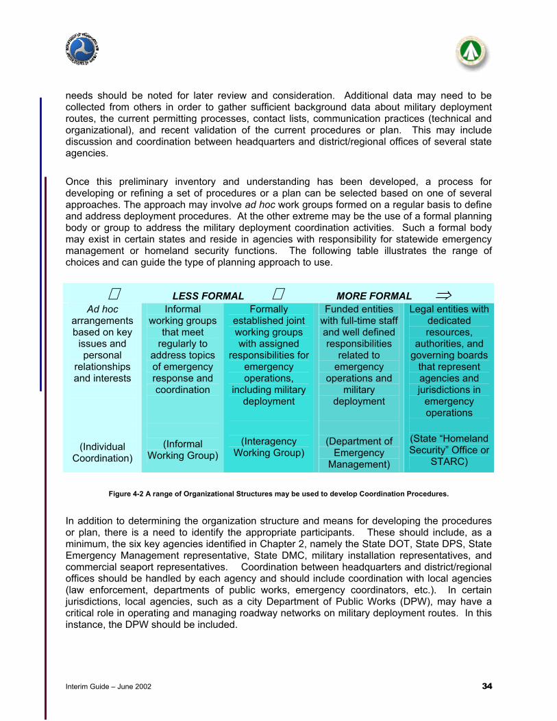
Interim Guide – June 2002 34
needs should be noted for later review and consideration. Additional data may need to be collected from others in order to gather sufficient background data about military deployment routes, the current permitting processes, contact lists, communication practices (technical and organizational), and recent validation of the current procedures or plan. This may include discussion and coordination between headquarters and district/regional offices of several state agencies. Once this preliminary inventory and understanding has been developed, a process for developing or refining a set of procedures or a plan can be selected based on one of several approaches. The approach may involve ad hoc work groups formed on a regular basis to define and address deployment procedures. At the other extreme may be the use of a formal planning body or group to address the military deployment coordination activities. Such a formal body may exist in certain states and reside in agencies with responsibility for statewide emergency management or homeland security functions. The following table illustrates the range of choices and can guide the type of planning approach to use.
Figure 4-2 A range of Organizational Structures may be used to develop Coordination Procedures.
In addition to determining the organization structure and means for developing the procedures or plan, there is a need to identify the appropriate participants. These should include, as a minimum, the six key agencies identified in Chapter 2, namely the State DOT, State DPS, State Emergency Management representative, State DMC, military installation representatives, and commercial seaport representatives. Coordination between headquarters and district/regional offices should be handled by each agency and should include coordination with local agencies (law enforcement, departments of public works, emergency coordinators, etc.). In certain jurisdictions, local agencies, such as a city Department of Public Works (DPW), may have a critical role in operating and managing roadway networks on military deployment routes. In this instance, the DPW should be included.
⇐ LESS FORMAL ⇔ MORE FORMAL ⇒ Ad hoc
arrangements based on key
issues and personal
relationships and interests
(Individual Coordination)
Informal working groups
that meet regularly to
address topics of emergency response and coordination
(Informal Working Group)
Formally established joint working groups with assigned
responsibilities for emergency operations,
including military deployment
(Interagency Working Group)
Funded entities with full-time staff and well defined responsibilities
related to emergency
operations and military
deployment
(Department of Emergency
Management)
Legal entities with dedicated resources,
authorities, and governing boards
that represent agencies and jurisdictions in
emergency operations
(State “Homeland Security” Office or
STARC)

Interim Guide – June 2002 35
As a result of this first step, the Emergency Response Coordinator will have a baseline description of existing procedures (if they exist), basic military deployment needs, organizational mechanisms for subsequent discussions and coordination across agencies, and the identification of key individuals and/or agencies.
Step 1) Getting Started Outcomes of Step 1
• Inventory past procedures and plans – develop a baseline
• Identify current or planned region/routes for deployments
• Identify existing forums or organizations who may have addressed the military deployment issue
• Identify participants
• Baseline of past procedures and plans, if they exist
• Deployment routes and affected regions, districts, jurisdictions
• The organizational mechanism for developing the procedures or plan
• The key participants and agencies
Figure 4-3 Summary checklist for Step 1 – Getting Started.
4.2.2 Step 2 - Gather Data/Identify Needs and Support Services The DMC will be one of the best sources of operational needs for a military deployment. This individual works closely with the deploying military installation to identify needs, establish and track the timing of major activities, coordinate with other DMCs as needed, and provide the primary interface with other state agencies. Because of the past working relationship among state agencies, military needs should be relatively routine and well defined. However, depending on the military mission, special needs may also be highlighted, such as unusual time-of-day movement needs, use of special vehicles, unconventional convoy operations or convoy sizing, use of alternative or restricted routes different from the standard routes, enhanced force protection and convoy monitoring, and other factors. As a result of special needs or the volume of convoy movements, additional agency resources may be needed or other agencies or organizations informed. For example, if substantial convoy movements are planned through a metropolitan area, traffic operation centers may need to be alerted about the timing and volume on the convoy routes. These deployment needs and supporting agency services should be identified since they may affect staffing and workload assignments. Supporting agencies also need to reconfirm their roles and responsibilities. Chapter Two highlighted the major functions and roles, but these need to be confirmed among the supporting agencies and participants to ensure proper allocation of responsibilities and resources. In step 3, of this 5-step development approach, these roles and responsibilities will be further refined during detailed discussions of activities, information flow, agency coordination, and decision-making. Agency representatives should also discuss their general preparedness to support military deployments. Such activities include:

Interim Guide – June 2002 36
• Updating point-of-contact lists with 24-hour accessibility to authorized decision-makers; • Establishing interagency communication systems (technical and organizational); • Providing for public safety and public information needs; • Identifying points of contact at regional and/or district offices, DPWs, and emergency
and transportation operations centers; and • Confirming the ability to access key information about approved convoy movements
such as existing permits, current and accurate roadway conditions, special needs, etc. Consideration should also be given to understanding everyday traffic conditions, civilian traffic management practices, incident management, specialized Hazmat needs, rapid procurement procedures, and agency authorities/regulations so that on-site and supporting personnel are aware of their baseline and special responsibilities plus interagency agreements during convoy movements. The intent is to build an understanding of major responsibilities and a trusting relationship among agencies during routine civilian and military deployment circumstances prior to the need for any special multi-agency response during convoy movements.
Step 2) Gather Data/Identify Needs Outcomes of Step 2
• Define operational concepts and needs for military deployments
• Determine supporting services from agencies
• Define roles, responsibilities, and priorities
• Identify special needs (special permits, traffic management, etc.) and providers
• Understanding of military deployment needs
• List of supporting services from agencies
• Confirmation of roles, responsibilities, and priorities
• List of special resources to support the military mission
Figure 4-4 Summary checklist for Step 2 – Gather Data/Identify Needs.
4.2.3 Step 3 - Define Agency Interactions and Preliminary Coordination
Procedures and Plan As a result of steps 1 and 2, background information and lists of civilian, military, and support agency needs have been identified. These needs should be matched to the typical phases of a military deployment, namely the issuance of a warning order, followed by the notice to deploy, and the actual convoy movements. In certain states, some of these phases may be combined. This alignment of needs will provide the basis for identifying agency activities, aligning resources, and documenting a set of coordination procedures or a plan. Based on the needs, agency representatives should describe a concept of operations, namely those activities the supporting agency will perform to meet the deployment needs with minimal impact to civilian traffic. Sometimes the activities will require the identification of resources and/or actions only from a single agency, e.g. SDOT will issue a permit. Other times, multiple
Interim Guide – June 2002 37
agencies will need to coordinate their actions, indicating such attributes as primary or secondary roles, points of contact, resource/information needs, etc. In the case of the SDOT, the following set of activities are typically considered:
• Inventory of existing highway conditions based on the proposed routes and military needs (work zones, construction locations, weight restrictions, operational chokepoints, etc.);
• Confirmation of selected routes (and possibly alternative routes) for convoy movements; • Assessment of traffic operations and/or traffic management needs to ensure effective
convoy movements and minimal disruption to civilian traffic; • Issuance of permits, priority permits, movement authorizations, and/or special permits
for military and commercial haulers; • Preparation for special needs or circumstances, e.g., rest areas, time-of-day restrictions,
etc.; • Monitoring of convoy movements and response to special needs of convoys-in-route; • Assessment of interagency coordination and areas for improvement; and • Verification of communication protocols and interoperability.
Once the sequence of activities by the military and support agencies have been delineated, key interaction and interface points can be identified. Figure 4-5 illustrates two types of interaction among key agencies: direction and control exchanges and coordination of information and activities. These interaction points help to define further the required information flow between and among agencies. Other activities may involve multiple agencies, as is the case for state and local law enforcement agencies. Other interactions involve all key agencies and organizations. For example, once a notice to deploy has been received, public affairs officers in all supporting agencies should be made aware of the impending convoy movements. This information will usually be “For Information Only” types of exchanges, but will provide valuable contact information if unusual circumstances or inquiries occur during the convoy movement phase. Similarly, interagency communications procedures and protocols during normal and emergency situations should be confirmed.

Interim Guide – June 2002 38
Figure 4-5 Key Coordination and interaction points are illustrated by dotted and solid lines. The State DOT representative
needs to coordinate closely with the DMC, EM, and Law Enforcement communities to ensure traffic planning and operations support military deployment needs.
Coordination and interaction points for traffic management and operations include such items as: • Interoperability of communication systems (800 MHz, 900 MHz, bridge circuits, common
dispatch centers, etc.); • Selected ramp metering controls to maintain desirable freeway speed and facilitate timely
convoy movements; • Public information notice via Highway Advisory Radio (HAR) broadcasts; • Use of special event signal timing plans to coordinate convoy movement; • Special use of service or freeway patrols to monitor convoy operations; • Increased visibility of convoy movements from the DMC to assist traffic engineers/operators
in monitoring and controlling traffic operations and military coordination (AVL, Internet) technologies which require interoperability;
• Use of variable or dynamic message signs to maintain or improve traffic operations during deployments (e.g., “convoys in center lanes”);
• Pre-positioning of critical assets (e.g., tow vehicles, service vehicles) or service patrols in potentially vulnerable segments of the highway network;
• Conditional uses of special travel lanes (HOV, Collector/Distributor systems, tunnels, etc.); • Coordination of citizen cellular phone traffic information among DPS and DOT operators;
and • Hand-off procedures among state, regional and local TMCs.
Law Enforcement
Emergency Management
State Area CommandDefense Movement
Coordinator
STATE & LOCALFEDERAL & MILITARY
Director of Logistics
Convoy Commander
Deployment RequirementsDirection & Control
Coordination
Threat InformationThreat Information
State Department of Transportation
Provost Marshall
Federal Bureau of Investigations
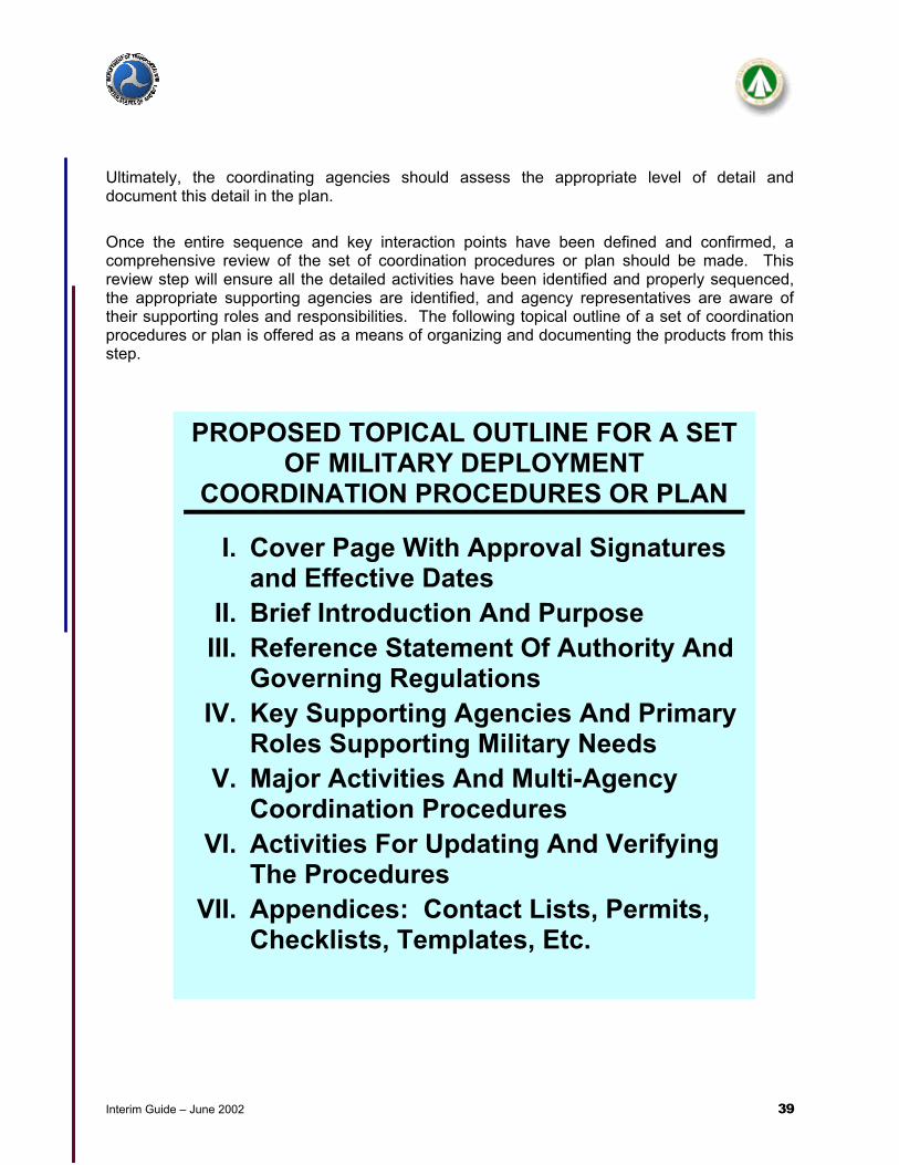
Interim Guide – June 2002 39
Ultimately, the coordinating agencies should assess the appropriate level of detail and document this detail in the plan. Once the entire sequence and key interaction points have been defined and confirmed, a comprehensive review of the set of coordination procedures or plan should be made. This review step will ensure all the detailed activities have been identified and properly sequenced, the appropriate supporting agencies are identified, and agency representatives are aware of their supporting roles and responsibilities. The following topical outline of a set of coordination procedures or plan is offered as a means of organizing and documenting the products from this step.
PROPOSED TOPICAL OUTLINE FOR A SET OF MILITARY DEPLOYMENT
COORDINATION PROCEDURES OR PLAN
I. Cover Page With Approval Signatures and Effective Dates
II. Brief Introduction And Purpose III. Reference Statement Of Authority And
Governing Regulations IV. Key Supporting Agencies And Primary
Roles Supporting Military Needs V. Major Activities And Multi-Agency
Coordination Procedures VI. Activities For Updating And Verifying
The Procedures VII. Appendices: Contact Lists, Permits,
Checklists, Templates, Etc.
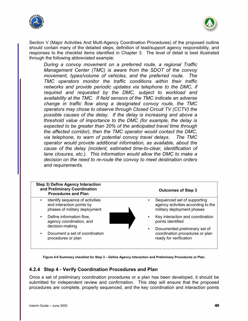
Interim Guide – June 2002 40
Section V (Major Activities And Multi-Agency Coordination Procedures) of the proposed outline should contain many of the detailed steps, definition of lead/support agency responsibility, and responses to the checklist items identified in Chapter 3. The level of detail is best illustrated through the following abbreviated example:
During a convoy movement on a preferred route, a regional Traffic Management Center (TMC) is aware from the SDOT of the convoy movement, types/volume of vehicles, and the preferred route. The TMC operators monitor the traffic conditions within their traffic networks and provide periodic updates via telephone to the DMC, if required and requested by the DMC, subject to workload and availability at the TMC. If field sensors of the TMC indicate an adverse change in traffic flow along a designated convoy route, the TMC operators may chose to observe through Closed Circuit TV (CCTV) the possible causes of the delay. If the delay is increasing and above a threshold value of importance to the DMC (for example, the delay is expected to be greater than 20% of the anticipated travel time through the affected corridor), then the TMC operator would contact the DMC, via telephone, to warn of potential convoy travel delays. The TMC operator would provide additional information, as available, about the cause of the delay (incident, estimated time-to-clear, identification of lane closures, etc.). This information would allow the DMC to make a decision on the need to re-route the convoy to meet destination orders and requirements.
Step 3) Define Agency Interaction and Preliminary Coordination
Procedures and Plan
Outcomes of Step 3
• Identify sequence of activities and interaction points by phases of military deployment
• Define information flow, agency coordination, and decision-making
• Document a set of coordination procedures or plan
• Sequenced set of supporting agency activities according to the military deployment phases
• Key interaction and coordination points identified
• Documented preliminary set of coordination procedures or plan ready for verification
Figure 4-6 Summary checklist for Step 3 – Define Agency Interaction and Preliminary Procedures or Plan.
4.2.4 Step 4 - Verify Coordination Procedures and Plan Once a set of preliminary coordination procedures or a plan has been developed, it should be submitted for independent review and confirmation. This step will ensure that the proposed procedures are complete, properly sequenced, and the key coordination and interaction points
Interim Guide – June 2002 41
have been identified. This independent review will also serve as a check for internal agency coordination procedures, i.e., all of the key offices or departments have or can provide the necessary information or decisions to support the preparedness activities and actual convoy movements. Several approaches exist for an independent review. One is to have an unbiased review team, composed of key agency representatives, review the document as if they were required to implement the action steps. This “role playing” approach allows for a limited group of individuals to simulate and highlight areas for improvement. Another approach is to conduct a tabletop exercise with several representatives from the military installation and supporting agencies. The tabletop exercise format would simulate the deployment process, including the use of specialized scenarios to test the robustness and completeness of the coordination procedures. Still another approach might utilize one or two experts to offer a detailed review and comments. The review procedures will vary from state to state, but the outcomes should be the same. Based on the independent review, a revised set of coordination procedures or plan should be developed and documented. These procedures should be sufficiently detailed and complete to allow all supporting agencies to “buy-in” or formally endorse the approach, as evidenced through an interagency memorandum, cover page signatures from agency representatives, or similar techniques. 4.2.5 Step 5 - Finalize Coordination Procedures and Plan Once the preliminary coordination procedures have been reviewed and revised, the final set of coordination procedures or plan should be documented. Part of the documentation should include activities for keeping the plan current through periodic reviews and updates at least annually. Specialized cross-agency training may be necessary, using the coordination procedures as a guide. Once completed, the document should be submitted for formal approval (signature) and distributed to the supporting agencies. Some agencies include the military deployment coordination procedures as part of the statewide emergency transportation management procedures.

Interim Guide – June 2002 42
5.0 SPECIAL CONSIDERATIONS The previous chapters presented information that will assist agencies plan and assist during a military deployment. There are different technical and policy considerations that are being developed (or are not used by all states) that can affect military deployment coordination. This chapter provides a look at some of the communication and technical systems, the role of Intelligent Transportation System technologies, the roles of Emergency Operations Centers (EOCs), and discusses briefly the emerging guidance for Force Protection in the United States. Each of these areas will be thoroughly reviewed for changes before this interim guide is finalized. 5.1 Communication Systems and Technology This section will cover deployment planning and execution tools, existing and future communications systems, and system alternatives. 5.1.1 Automated Planning Tools There are a number of military transportation command and control systems, automated information systems (AISs) and automatic identification technologies (AITs) designed to assist in transportation planning, management and execution. What follows is a description of selected systems and capabilities. 5.1.1.1 Highway Conditions Reporting System This system provides a comprehensive daily view of the state’s road conditions on major highways and arterials. The conditions report is assembled daily by the department of transportation at the district level and includes reports on planned work zones, construction, detours, road closures, and other planned events which may affect the capacity and safety of roadway travelers. The system is web-based with unrestricted viewing and printing access. The web site offers listings of roadway conditions by type of roadway (interstate, state highway, etc.), by geographic location (county or department of transportation district), and by condition. 5.1.1.2 Mobilization Movement Control System (MOBCON) This system deconflicts convoys moving throughout CONUS allowing the Defense Movement Coordinator (DMC) to control the density of military traffic at any given time on all state roads, freeways and interstates. The convoy clearance function will essentially give units permission to occupy a particular road space at a specific time. It is not accessible outside of military transportation channels which thus requires additional coordination between the DMC and state agencies to ensure that the system has the most accurate information about road closures, weather conditions and other problems that may impede convoy route scheduling or affect convoys already in transit. 5.1.1.3 Intelligent Road/Railroad Information Server(IRRIS) This system allows real-time access to information via a controlled access website. (Please contact MTMCTEA at www.tea.army.mil for password procedures.) It combines data from the

Interim Guide – June 2002 43
following types of systems: Global Positioning System (GPS), Geographic Information System (GIS), and Intelligent Transportation System (ITS). In addition, current data elements related to information required by the MOBCON system (see 5.1.1.2) is identified for Army users and current power projection routes are included in the interactive mapping element of the program. 5.1.2 Current Communication Systems Current deployment communication systems have some problems. Current Communication systems essentially rely on telephone lines to move information from one area to another. The following communication challenges have been identified:
• Radio systems between military and civilian agencies supporting deployments are not compatible
• A lack of repeaters along the routes limits the range of radios to communicate back to the installation or to the port.
• Cellular phones experience gaps in coverage and periods of non-availability • Route change information would be difficult to pass on to the convoy commanders on
the move • Cellular phones an approved backup for telephones are not issued to convoy
commanders. They typically use their personal phones.
5.1.2.1 Land Line Telephones Telephones are the primary means of communication and coordination for deployment operations. Typically, these lines are only available in fixed facilities. Telephone contact lists are available in the military and civilian command centers. 5.1.2.2 Cellular Phones Cellular phones are not issued to convoy commanders; however, most commanders have them available to communicate with the IOC/MCC and other support agencies along the route. Gaps in coverage, frequency or protocol incompatibility, and system overload may limit cell phone capabilities. 5.1.2.3 Tactical Radios Communications within the convoy are conducted using tactical radios. These radios have a limited range and are not compatible with civilian radio systems. 5.1.3 Future or Additional Communications Systems or Methods 5.1.3.1 Movement Tracking System (MTS) This is a commercial, off-the-shelf, vehicle tracking and communication system that allows two-way text messaging and utilizes satellite technology. This system is ideal for knowing the location of vehicles without having to ask the driver and for sending messages to and from the vehicle. The system provides highly efficient, fast and secure communications over satellites specifically for mobile data communications. Embedded within the system is an automatic GPS function that generates position reports.

Interim Guide – June 2002 44
5.1.3.2 Satellite Communication Systems Enhanced satellite communication systems with receivers and transmitters in the operations centers, command posts, and command vehicles would allow for greatly improved deployment communications. 5.1.3.3 Using Existing Systems Alternatives Passing information to a convoy on the move when conventional methods are not available or ineffective could be accomplished by involving one of the regional State Police dispatch centers. For instance, convoy re-route information could be called in to a regional, 24 hr. dispatch center. The dispatch center could relay the information concerning the convoy’s approximate location and route change information via radio to a state police officer. The officer would then locate the convoy and verbally pass the information to the convoy commander face-to-face. 5.2 Role of ITS Technologies Intelligent Transportation Systems (ITS) collect, store, process, and distribute information related to the movement of people and goods. Examples include systems for traffic management, public transportation, emergency management, traveler information, advanced vehicle control and safety, commercial vehicle operations, electronic payment and railroad grade crossing safety.
Figure 5-1 Portable Traffic Control Devices can assist with Work Zone Activities.

Interim Guide – June 2002 45
There are items of information that, if gathered and distributed in a timely way, can positively affect both how the transportation system functions and its safety. The information collected and used in ITS can benefit a wide-range of users, including military deployment planners and commanders. To be effective, a unified framework or architecture for integrating many of the ITS components is needed and must be followed. Implementation of ITS technologies will require resources and expertise from many disciplines, including the military. The following figures demonstrate the relationship between ITS and military deployment requirements:

Interim Guide – June 2002 46
Figure 5-2 ITS Technologies That May Support Military Deployments
Additional information about ITS technologies can be found at: www.its.dot.gov
Military Deployment Concern
Applicable ITS Technology Purpose State-Of-The-Practice
Weigh-In-Motion Systems (WIMs) Eliminate requirements for vehicle stops and weight checks. Approximately 10 states have some form of WIM. Increasing use by other states.
Electronic Vehicle ScreeningProvide pre-clearance for commercial vehicles for safety
inspections and port-of-entry processing locations. Saves time by eliminating vehicle stops.
Approximately 15 states have some form of pre-clearance program.
Commercial Vehicle Information System Network (CVISN)
The Commercial Vehicle Information Systems and Networks program (CVISN) is an integration of information systems and
networks designed to enhance motor carrier and roadway safety and improve the performance of commercial vehicle operations
and state regulations.
Approximately 35 states have implemented some form of CVISN architecture or program area.
Military Deployment Concern
Applicable ITS Technology Purpose State-Of-The-PracticeAutomatic Vehicle Identification
(AVI) and automatic vehicle location (AVL).
Use of on-board transponders technology with remote receivers to automatically identify and locate vehicles.
Increasing usage, especially in the commercial vehicle industry and transit industry. Signals can be encrypted.
Archived Data Services Use of archived data from the SDOTs or TMCs to understand nominal traffic patterns during in-transit movement.
Archived data is starting to be used to assist with baselining and planning activities.
Closed Circuit Television (CCTV) Observe real-time road conditions.Widely used in regional traffic centers resulting in high-quality color images with full Pan/Tilt/Zoom imaging and
storage capabilities.
Military Deployment Concern
Applicable ITS Technology Purpose State-Of-The-Practice
Collision Avoidance Systems Use of on-board sensors and other devices to warn drivers of impending collisions and erratic lane changes.
First generation devices available on some commercial and personal vehicles.
Biometric Safety AidsUse of biometric technologies (Retinal scans, facial recognition,
fingerprint identification, etc.) to ensure safe and authorized operation of equipments.
Emerging technology with limited field-testing and implementation.
Grade-Crossing Collision Avoidance Systems
Use of advanced sensor technologies and warning devices to reduce the number of vehicle-train collisions at at-grade
crossings.
Increased installation of the equipment, especially at sites with high accident records.
Military Deployment Concern
Applicable ITS Technology Purpose State-Of-The-PracticeTraveler Information Systems
(Including “511” telephone services)
Provide basic information about roadway conditions, work zones, incidents, recurring congestion, expected delays, and
possible alternative routes.
Emerging national network on road closures and traveler information. 511 traveler information services available
in 4-5 major metropolitan areas. See www.fhwa.dot.gov/trafficinfo.
Weather Advisory Systems Provide current and forecasted weather information that may affect roadway conditions and/or travel.
Information usually coupled with roadway conditions reporting systems. Some commercial services available.
Emergency Response Systems Provide quicker response in case of on-road emergencies, potentially saving lives and clearing incidents quicker.
Developed in various forms, including integrated incident management teams, enhanced communications
equipment, E911 services, and others.
Synchronized Traffic Control Systems
Improve time-of-day adaptive control of signal networks. Limited, but growing, application in major metropolitan areas.
Signal Pre-emption Systems Allows emergency or special vehicles priority access through signalized intersections.
Limited, but growing, application in major metropolitan areas.
Dynamic Message Signs (DMS) Provide information about roadway conditions and possible alternative routes, as needed.
Increasing use of DMS, especially in major metropolitan areas.
Highway Advisory radios (HAR) Provide localized traveler information on AM frequencies near areas of interest, work zones, or incidents. Widely used by almost all states.
Ramp Metering Systems Control the volume of traffic entering a freeway to help maintain a desired level of service on the freeway.
Systems installed and operating in several metropolitan areas.
Electronic Toll Tags and Tag Management (ETTM)
Use of short-range communications equipment and protocols to automatically debit an account for toll facility usage.
Used in many states. Increased usage expected. Saves time in processing at collection points, thereby
minimizing congestion.
Assured Access to Roadways
Oversize/Overweight
In-transit Visibility
Safety

Interim Guide – June 2002 47
5.2.1 Traffic Management Centers Traffic Management Centers (TMCs) are a consolidated and organized means of monitoring and actively managing roadway and transit conditions in a specific geographic area, usually a major metropolitan area. TMCs provide conditions and management reports to the public, through web sites, partnerships with mass media, telephone reports, and other means. TMCs usually operate on a 24x7 basis and provide transportation network conditions reports, including incidents, congestion points, transit operations, and freeway management for the regions they serve. Much of this information is acquired through ITS technologies, which may include Closed-Circuit TV (CCTV), roadway loop sensors, probe vehicles, Automatic Vehicle Location (AVL) systems, weather reports, emergency response reports, information from citizens or CVOs, and other sources. Because a TMC monitors, analyzes, synthesizes, reports, and manages (to a certain extent) the roadway and transit system, they represent a desirable source of information and operational coordination during military deployments. A typical TMC involves the department of transportation (state and/or local DPW), transit authorities, police, fire, and emergency services providers. The extent of their participation will vary depending on the state, regional and local organizations and jurisdictional authorities. A TMC is usually owned and operated by the State Department of Transportation, although some TMCs are owned and/or operated by other agencies or authorities. Some TMCs have the ability to control HOV or special access lanes that may be desirable or required during deployments. TMCs also coordinate freeway patrol units that also assist with deployment operations.
Figure 5-3 Traffic Management Centers such as TranStar in Houston, Texas give a live view of current weather and traffic
conditions. These views can be accessed by all agencies through the Internet.
5.2.1.1 Role of A TMC During Convoy Operations A primary role of the TMC during normal civilian operations is to monitor the roadway conditions and report unusual conditions to the public. As noted previously, it is desirable for the convoy to

Interim Guide – June 2002 48
avoid major metropolitan areas during periods of rush hour traffic and travel, typically between 6-9am and 4-7pm on weekdays, although these times may vary based on location and special event conditions. If special events in the TMC’s coverage area are planned, the TMC is likely to be aware of the transportation implications and can share this information with DMC and other convoy planners, who can then assess the desirability of a proposed route. During a convoy deployment through an area that has a TMC, it is desirable for the TMC to be alerted by the DMC to the approximate time, size, and duration of the convoy movements. Moreover, if there are special materials or travel conditions associated with the convoy movement, the TMC should be notified. This information will allow the TMC to be prepared for any special contingencies that may arise. If a specially designated route, as requested by the DMC, was through a TMC coverage area, the TMC would assist state and local authorities in the preparation, management, and restoration of the roadway travel conditions necessitated by the special route. Such a situation may be necessary during other special events, e.g., Presidential visit, major sporting event, etc, for which event-driven protocols have usually been established. During these special events, the TMC is prepared to assist the responsible agency in planning and operational requirements. The DMC would need to coordinate closely with the TMC to ensure this coordination and preparedness is achieved. 5.2.1.2 TMC Actions During Convoy Operations The TMC’s primary role is to monitor and manage the roadway conditions for adequate capacity and to alert the public to roadway conditions that may reduce mobility and safety of the traveling public. TMCs have been formed and organized to operate with enhanced interoperability among emergency responders and the transportation community. This provides military convoy planners and commanders with a comprehensive, single point of contact when traveling in their jurisdiction. During normal operations, the TMCs are monitoring roadway conditions and alerting the public of possible delays, incidents, or other roadway or transit conditions that may affect mobility and safety. During incidents, the TMCs coordinate emergency response to the event, manage traffic operations, and alert the public (as appropriate) to the location of the event, expected delays, possible alternative routes, and other desired community information. Unless prearranged, no specialized reporting to military organizations is offered. Communication with the TMC is through conventional communication systems including landline phones, a web site, and separate and sometimes integrated communication systems of police, fire, transit, and other emergency responders. Military deployment planners will need to identify the best means for communicating with TMCs prior to the convoy deployment and confirm the interoperability of military-TMC communication systems. During a military deployment in a TMC surveillance area, no operational changes are typically made at the TMC. However, the TMC’s roadway and transit conditions information will be valuable to convoy commanders. For example, if there is a major incident along the planned and approved deployment route, the convoy commander would need this information in

Interim Guide – June 2002 49
sufficient detail to determine if a change in convoy operations is needed, i.e., change in route, temporary rest stop to allow the incident to be cleared, or other possible courses of action. Consequently, the convoy planners will need to plan and operate communication systems that enable the DMC and convoy commanders to capture this type of real-time information. 5.3 Emergency Operations Centers (EOCs) Federal, military and civilian agencies use Emergency Operations Centers (EOCs) to control aspects of an emergency, incident or major operation. Typically, EOCs are locations equipped with enhanced communications where decision makers gather to facilitate the resolution of problems. EOCs are command and control nerve centers that allow representatives from various departments or agencies to meet and work within the EOC to control or react to emergencies or major operations. As Figure 5-8 demonstrates, the State DOT and Emergency Management agencies have a responsibility to communicate and exchange vital information during an emergency. This often requires that plans and contacts are established and maintained routinely. The following sections describe the responsibilities and capabilities of some of these EOCs: 5.3.1 Military Emergency Operations Centers Military operations centers dealing with a military deployment can usually be found at the deploying installation and the ports of embarkation. Intermediate command posts may also be found along convoy routes. 5.3.1.1 Installation Operations Center (IOC) / Movement Command Center (MCC) When an installation is issued a port call message, the installation activates the movement command center (MCC) as part of the installation operations center (IOC). The installation operations center will be staffed to coordinate operations, intelligence, logistics, and administration functions. The IOC is the controlling activity to coordinate deployment operations.
Figure 5-4 State DOT and EmergencyManagement are directly connected andshould plan and communicate before anemergency occurs.
Law Enforcement
Emergency Management
State Area CommandDefense Movement
Coordinator
STATE & LOCALFEDERAL & MILITARY
Director of Logistics
Convoy Commander
Deployment RequirementsDirection & Control
Coordination
Threat InformationThreat Information
State Department of Transportation
Provost Marshall
Federal Bureau of Investigations

Interim Guide – June 2002 50
5.3.1.2 Intelligence Installation intelligence personnel are required to provide threat information to the commander and the convoy commanders. The threat information can be related to military facilities, equipment, information systems and personnel both on and off the military installation. 5.3.1.3 Logistics
• The Logistics Movement Command Center (MCC) function of the IOC is responsible for coordinating the following: All necessary support services and transportation requirements of the deploying units.
• Establish and operate a marshaling area to support the reception of the moving convoys at the port.
• Establish, train, and equip a PSA to support surface movement of forces traveling through assigned SPOE.
• Direct the activities of the Installation Unit Movement Coordinator (UMC) and Movement Officers (UMO) during the deployment process.
• Coordinate convoy route approvals and alterations with the state Defense Movement Coordinator.
• Communicate route changes or time adjustments to convoy commanders prior to departure or while en route. En route changes are relayed to commanders at the rest/refueling stops, via cell phone, via police escort or through the area law enforcement dispatchers.
5.3.1.4 Seaport of Embarkation Operations Center – Joint Military/Civilian Center Upon notification of a deployment with established port calls, port officials and support agencies meet to establish action priorities. A formal operations center is usually established upon the arrival of the Port Support Activity personnel from the deploying installation. This operations center is responsible for coordinating the following:
• The overall supervision and management of PSA and convoy operations • Lodging, meal and return transportation for personnel supporting port and convoy
operations • Port labor • Port security requirements • Convoy staging areas • Communication with IOC and the MCC
5.3.2 Civilian Emergency Operations Centers (EOCs) Civilian Emergency Operations Centers, while not specifically designed to control or facilitate the movement of convoys, can be a useful central point of contact to help resolve problems involving convoy operations. Civilian agency representatives are present in these EOCs and are accustomed to working together to respond and recover from emergencies. 5.3.2.1 State Emergency Operations Center (EOC) The Governor of the state customarily activates the State EOC during times of disaster or emergency. The State EOC brings together state agencies for the purpose of coordinating and

Interim Guide – June 2002 51
prioritizing the use of critical resources. The following state agencies and other organizations could impact deployment operations from the State EOC:
• Department of Transportation • Department of Public Safety • Office of Emergency Management • State Attorney General • National Guard • Volunteer Organizations Active In Disasters (American Red Cross, Salvation Army, other
disaster services organizations)
The State EOC has the ability to communicate directly with all county/parish emergency management offices, all state police troops or districts and federal agencies. In this capacity, the state EOC could provide an excellent communications backup for deployment operations. 5.3.2.2 Regional Emergency Operations Center Some states have regional Emergency Operations Centers that coordinate the disaster/emergency response of multiple communities within a geographic region. Like the State EOC, these regional EOCs have the ability to communicate with agencies within the region. The EOC is able to coordinate assistance to convoy operations moving through their region. 5.3.2.3 County/Local Emergency Operations Center Each county/parish in the country has an emergency manager. Many counties/parishes have an emergency operations center. In these centers, county/parish agencies and volunteer organizations come together to deal with emergencies, disasters or special events. These EOCs have direct communication with local law enforcement, fire services, and EMS within the jurisdiction. In addition, they are accustomed to working with the State EOC in the resolution of emergency related problems. 5.3.2.4 Department Of Public Safety/State Police Dispatch Centers These centers have the ability to become an operations center to handle emergencies. Primarily these centers dispatch and control the activities of state police officers within the state. All of the dispatch centers are linked by radio and can coordinate inter-region police activities. These dispatch centers have direct links into local law enforcement dispatch centers and into the county/parish EOCs and the State EOC. Coordination of State Police support to convoy operations should go through this dispatch center. These centers are manned 24/7 and can provide deployment controllers with the ability to communicate with convoys through the state police officers on the road. 5.3.2.5 Local Law Enforcement Dispatch Centers Sheriff’s offices and city police offices each have the ability to dispatch their officers or deputies. These dispatch centers have the ability to communicate and coordinate the activities of emergency responders throughout their community. In addition, they also have radio

Interim Guide – June 2002 52
communication with State police and the county/parish, regional and State EOCs. Coordination of local law enforcement support to convoy operations should go through this dispatch center. 5.4 Force Protection Force protection of military assets is a concept that military strategists and tacticians have dealt with throughout history. Doctrine, plans and procedures that cover the protection of military assets have been formulated to cover the period of time after the forces arrive in the area of operations until they go into battle. Until recently there has been little motivation to develop doctrine, plans or procedures for protecting troops on the move in the continental United States (CONUS). The events of September 11, 2001 have caused the military and national leaders to reconsider how and when critical military assets are to be protected. National CONUS force protection doctrine is being developed. The guidance for the development of CONUS force protection plans, procedures and tactics will come from that doctrine. The following factors will require consideration when developing military deployment force protection plans, procedures and tactics:
• Terrorist targets may include infrastructure (bridges, tunnels, highway overpasses) or the convoys, military equipment, trains or soldiers.
• State and local law enforcement agencies do not possess the manpower or equipment to respond to a serious domestic terrorist threat to convoys on the move.
• Available intelligence on threats to specific convoys will be limited to non-existent. • The sharing of intelligence threat information between the military and civilian
deployment support agencies will be critical to force protection planning and execution. • Any military solutions to deployment force protection must be accompanied by CONUS
specific training for those soldiers performing the force protection missions. • National Guard assets, while an excellent source of military expertise, may not be
available due to other commitments. • Existing threat condition actions currently do not directly pertain to protecting convoys.

Interim Guide – June 2002 53
A. KEY TERMS Access road An existing or proposed public highway from a military reservation, defense industry, or activity to suitable transportation facilities. (This may include public highways through military installations when they are dedicated to public use and, by fee simple or easement, are owned, operated, and maintained by civil authority.) Brigade (BDE) A unit usually smaller than a division to which are attached groups and/ or battalions and smaller units tailored to meet anticipated requirements. Cargo Item(s) or freight to be moved, including items on or in a vehicle, towed by a vehicle or a vehicle itself. Commercial carrier Common, contract, for-hire, and private carriers. Convoy The movement of any group of six or more vehicles temporarily organized to operate as a column, with or without escort, proceeding together under a single commander; or to the dispatching of 10 or more vehicles per hour to the same destination over the same route. Column formation A formation in which elements are placed one behind the other. Column gap The space between two consecutive elements proceeding on the same route. It can be calculated in units of length or in units of time measured from the rear of one element to the front of the following element. Column length The length of the roadway occupied by a column or a convoy in movement. Dimension limitation The overall width, length, or height of a vehicle or combination of vehicles, or combination of vehicle and lading. Division A major administrative and tactical unit/formation which combines in itself the necessary arms and services required for sustained combat, larger than a regiment/brigade and smaller than a corps. Dwight D. Eisenhower National System of Interstate and Defense Highways (NSIDH) A limited system highway in the United States of 42,500 miles as established by law. Highways are to be located so as to connect by routes, as direct as practicable, the principal metropolitan areas, cities, and industrial centers to serve the national defense, and at suitable border points with routes of continental importance in the Dominion of Canada and the Republic of Mexico. Earliest arrival date (EAD). A date specified by the supported Commander in Chief (CINC) that is the earliest date when a unit, a resupply shipment or replacement personnel can be accepted at a port of debarkation

Interim Guide – June 2002 54
(POD) during a deployment. It is used with the latest arrival date to define a delivery window for transportation planning. Essential cargo Cargo essential for accomplishment of a military mission in accordance with the definition of mission as well as Essential Materiel specified in the Uniform Materiel Movement and Issue Priority System (UMMIPS), DOD Directive 4410.6, or cargo which is essential for prosecution of a war or for national survival during the survival period. Emergency highway traffic regulation plan A system of traffic management and control devised to regulate the use of highways and to expedite and facilitate urgent vehicle movement by highway just before, during, and just after a national security emergency. Emergency highway traffic regulation (EHTR) A regulation that contains plans, routes, and schedules of the actual use of highways to help the orderly flow of traffic during a national emergency. This includes evacuation, regulating movement through dangerous areas, and clearing priority traffic over routes of limited capacity. Executive Order (EO) 12656 Assignment of Emergency Preparedness Responsibilities dated November 18, 1988, as amended. Highway network The total system of highways, roads, streets, bridges, tunnels and related facilities, including all toll facilities, regardless of financing. Highway movement essential to national defense Essential cargo which cannot be reduced in size or weight, or moved by another mode of transportation, and which has been determined eligible for certification for highway movement. Installation road A road or street within a military reservation or in which the DOD has real estate interest. It is not dedicated to public use and is not eligible for improvement with defense access road funds. Latest arrival date (LAD) at the APOD/SPOD A date specified by the supported Commander in Chief (CINC) that is the latest date when a unit, a resupply shipment or replacement personnel can be accepted at a Port of Debarkation (POD) and support the concept of operations. It is used with the earliest arrival date to define a delivery window for transportation planning. Legal limitation The statutory, administrative, or other regulations governing permissible length, width, height, loads, tire pressure, performance limits or other characteristics, for vehicles serving in regular operation. Regular operation does not include the operation of vehicles or combinations of vehicles in excess of legal limitations, which must be authorized by special permit issued by an appropriate civil authority. Movement authorization A legal form issued to authorize movement of a load or vehicle over regulated routes during lower traffic periods, and/or other specific periods as determined by the traffic regulation agencies, to optimize traffic handling and road use. N-day The unnamed day an active duty unit is notified for deployment or redeployment.

Interim Guide – June 2002 55
N-Hour Notification Hour (N+1, N+5 etc) National security emergency Any occurrence including military attack, technological emergency, or other emergency, that seriously degrades or seriously threatens the national security of the United States. Permit A written authorization to move or operate on a highway a vehicle or vehicles with load of size, weight or other characteristics (such as hazardous materials shipments) exceeding the legal limitations prescribed for vehicles in regular operation and/or during restricted hours or on Saturdays, Sundays, or holidays. Port of embarkation (POE) The geographic point in a routing scheme from which cargo or personnel depart. This may be a seaport or an aerial port from which personnel and equipment flow to a port of debarkation. Port of debarkation (POD) The geographic point in a routing scheme where cargo or personnel arrive. Port operations group A task-organized unit, located at the seaport of embarkation and/or debarkation under the control of the landing force support party and/or combat service support element, that assists and provides support in the loading and/or unloading and staging of personnel, supplies, and equipment from shipping. Port Planning Order (PPO) An agreement between a commercial port and the military to provide staging space and port support to meet military deployment needs. Port security The safeguarding of vessels, harbors, ports, waterfront facilities, and cargo from internal threats such as destruction, loss, or injury from sabotage or other subversive acts; accidents; thefts; or other causes of a similar nature. Port support activity (PSA) A tailorable support organization composed of mobilization station assets that ensures the equipment of the deploying units is ready to load. The port support activity (PSA) operates unique equipment in conjunction with ship loading operations. The PSA is operationally controlled by the military port commander or terminal transfer unit commander. Power projection The ability of a nation to apply all or some of its elements of national power - political, economic, informational, or military - to rapidly and effectively deploy and sustain forces in and from multiple dispersed locations to respond to crises, to contribute to deterrence, and to enhance regional stability. Power Projection Platforms (PPP) Military installations that strategically deploy one or more high priority active components brigades (or larger). The military installation may also mobilize and deploy high priority reserve component units. Priority permit A legal permit form issued to authorize movement of a load or vehicle between two or more points over regulated routes within specified time limits.

Interim Guide – June 2002 56
Ready-to-load date (RLD) The date when the unit will be prepared to depart from its origin. Replacement road A public road that must be built to replace a public highway or street that has been, or will be, closed to public use because of construction, expansion, security or safety requirements of a military installation or defense industry. Required delivery date (RDD). A date when a unit or material must arrive at its destination and complete offloading to properly support the military operation. Regulated routes Highways, roads, and streets, or portions thereof, which must be subjected to regulation because of hazardous conditions, special uses, or limited capacity in relation to demand. Regulated routes – Class A Highways, roads and streets, or portions thereof, which lie within an area contaminated by radioactivity or other material or circumstances that are hazardous to the life and health of highway users. These roads may be used with special guidance precautions and practices. Regulated routes – Class B Highways, roads and streets, or portions thereof, which are temporarily reserved exclusively for a special purpose, such as military movements or civil defense movements or other priority vehicles may be allowed to use this route with priority permits. Regulated routes – Class C Highways, roads and streets, or portions thereof, which are determined to have, or which are expected to develop, critical capacity restrictions, and on which travel is generally limited to holders of road use permits. Roads "open to public travel” Roads on military installations where dependents, visitors, and other members of the public are permitted access. To have identification to enter a road does not exclude it from being a road "open to public travel." Single Port Manager (SPM) US Transportation Command, through its transportation component command, Military Traffic Management Command, is designated as the single port manager for all common-user seaports worldwide. The single port manager performs those functions necessary to support the strategic flow of the deploying forces’ equipment and sustainment supply in the sealift port of embarkation (SPOE) and hand-off to the geographic commander in chief (CINC) in the sealift port of debarkation (SPOD). The single port manager is responsible for providing strategic deployment status information to the CINC and to workload the SPOD Port Operator base on the CINC’s priorities and guidance. The single port manager is responsible through all phases of the theater port operations continuum, from a bare beach deployment to a commercial contract supported deployment. Traffic engineering That phase of engineering that involves planning, geometric design, and traffic operations of roads, streets, and highways. It includes their networks, terminals, abutting land, and relationships with other modes of transportation for safe, efficient, and convenient movement of persons and goods. Traffic regulation posts

Interim Guide – June 2002 57
Control points at each end of or along regulated routes, for controlling the flow of traffic onto or on the route, checking road use permits, and advising occupants of vehicles of any dangers. Weight limitation Applies to axle loads and spacing, and to the gross load of a vehicle, or combination thereof. Warning order A planning directive that describes the situation, allocates forces and resources, establishes command relationships, provides other initial planning guidance, and initiates subordinate unit mission planning. Vehicle distance The clearance between vehicles in a column that is measured from the rear of one vehicle to the front of the following vehicle.

Interim Guide – June 2002 58
B. ACRONYMS
AC Active Component AHA Ammunition Holding Area AIS Automatic Identification Systems AIT Automatic Identification Technologies ALD Available-to-Load Date APOD Airport of Debarkation APOE Airport of Embarkation AR Army Regulations ARNG Army National Guard ASCC Army Service Component Command ATF Alcohol, Tobacco and Firearms AVI Automatic Vehicle Identification AVL Automatic Vehicle Location CAP Crisis Action Planning C2 Command and Control CAV Calvary CCN Convoy Clearance Number CCTV Closed Circuit Television C-DAY Day on which deployment operations commence CINC Commander in Chief CJCS Chairman of the Joint Chiefs of Staff CMO Convoy Movement Order CNN Convoy Clearance Number COE Common Operating Environment COMPASS Computerized Movement Planning & Status System CONOPS Concept of Operations CONPLANS Concept of Operation Plans CONUS Continental United States CP Control Points CVISN Commercial Vehicle Information System DEL Deployment Equipment List (to be replaced by UDL) DMC Defense Movement Coordinator DMS Dynamic Message Signs DoD Department of Defense DOL Directorate of Logistics DOT Department of Transportation DPS Department of Public Safety DPW Department of Public Works

Interim Guide – June 2002 59
DRF Division Ready Force DTR Defense Transportation Regulation DSB Deployment Support Brigade DST Deployment Support Team EAD Earliest arrival date EHTR Emergency highway traffic regulation EOC Emergency Operations Center EMS Emergency Management Services ETTM Electronic Toll Tags and Tag Management FBI Federal Bureau of Investigation FEMA Federal Emergency Management Agency FHWA Federal Highway Administration FM Army Field Manuals GBL Government Bill of Lading GCCS Global Command and Control System GIS Geographic Information System GPS Global Positioning System GTN Global Transportation Network HAR Highway Advisory Radios HAZMAT Hazardous Material HETS Heavy Equipment Transport System HSAS Homeland Security Advisory System IAW In accordance with IBS Integrated Booking System IOC Installation Operations Center IRRIS Intelligent Road/Railroad Information Server IRC Initial Ready Company IMDG International Marine Dangerous Goods ITO Installation Transportation Officer ITS Intelligent Transportation System ITV In-transit Visibility JOPES Joint Operation Planning and Execution System LAD Latest arrival date at the APOD/SPOD LNO Unit Liaison Officer MA Marshalling Area MACOMS Major Commands MARAD Maritime Administration MCC Movement Control Center MCS Marine Cargo Specialist MHE Materials-Handling Equipment
Interim Guide – June 2002 60
MILVAN Military-Owned Remountable/Demountable Container MOBCON Mobilization Movement Control System MP Military Police MSC Military Sealift Command MSL Military Shipment/Shipping Label MTMC Military Traffic Management Command MTMCTEA Military Traffic Management Command Transportation Engineering Agency MTS Movement Tracking System N-hour Notification Hour (N+1, N+5 etc) NSIDH National System of Interstate and Defense Highways OPCON Operational Control OPLAN Operation Plans OPORD Operation Orders PAO Public Affairs Officer PMO Provost Marshall Office POC Point of Contact POD Port of Debarkation POE Port of Embarkation PORTSIM Port Simulation PPCE Personal Protective Clothing and Equipment PPP Power Projection Platform PPO Port Planning Order PSA Port Support Activity RC Reserve Component RDD Required delivery date RDL Ready-to-load date RF Radio Frequency RORO Roll-on Roll-off RP Release Point SDOT State Department of Transportation SITREP Situation Report SMCC STARC/State Movement Control Center SP Start Point SPOD Seaport of Debarkation SPOE Seaport of Embarkation SPM Single Port Management STARC State Area Command STRAHNET Strategic Highway Network TEA Transportation Engineering Agency

Interim Guide – June 2002 61
TISA Troop Issue Subsistence Activity TMC Traffic Management Center TMS Traffic Management Systems TPFDD Time-Phased Force Deployment Data TRADOC U.S Army Training and Doctrine Command TRANSCOM United States Transportation Command TTB Terminal Transportation Battalion UDL Unit Deployment List UMC Installation Unit Movement Coordinator USAR United States Army Reserve USCG United States Coast Guard UIC Unit identification Code UMO Unit Movement Officer UMT Unit Movement Team USTRANSCOM United States Transportation Command WIMs Weigh-In-Motion Systems WPS Worldwide Port System WWW Worldwide Web

Interim Guide – June 2002 62
C. LIST OF POWER PROJECTION PLATFORMS
Each of the Army and Marine Corps power projection platforms (PPP) has a designated seaport of embarkation (SPOE). In some cases, the SPOE is an extended distance from the (PPP) and for those installations; rail may be the primary mode of transport.
US Military Power Projection Platforms and Scheduled Seaport of Embarkation (SPOE)
Installation SPOE Deploying Soldiers
(Rounded to the Nearest 5,000)
Ft. Hood TX Beaumont & Corpus Christi TX 75,000 Ft. Bragg NC Wilmington NC & Charleston SC 50,000 Ft. Drum NY New York NY & Bayonne NJ 40,000 Ft. Campbell KY Jacksonville FL 40,000 Ft. Stewart GA Savannah GA 35.000 Ft. Riley KS Wilmington NC & Savannah GA 35,000 Ft. Lewis WA Seattle Tacoma WA 25,000 Ft. Carson CO Norfolk VA 20,000 Ft. McCoy WI New York NY 15,000 Ft. Polk LA Beaumont TX 15,000 Ft. Dix NJ New York NY 15,000 Ft. Bliss TX Beaumont & Corpus Christi TX 10,000 Ft. Sill OK Beaumont TX 10,000 Ft. Benning GA Savannah GA 10,000 Ft. Eustis VA Norfolk VA 5,000 Camp Pendleton CA San Diego CA TBD Camp Lejuene NC Morehead City NC TBD Additional SPOEs Long Beach CA NWS Concord CA Oakland, CA Port Hueneme CA

Interim Guide – June 2002 63
The following graphic provides a nation-wide view of the installations designated as power projection platforms and the commercial ports that are designated as strategic seaports of embarkation (SPOEs). It is worthy to note that units may deploy to locations other than SPOEs in order to protect national interests.
Map of Power Projection Platform States
Interim Guide – June 2002 64
D. REFERENCES The references identified in this section were utilized to create the Interim Guide. Where possible, Internet links have been provided. The reference information is listed by agency in the following order: United States Government, Department of Defense, States, and Commercial Sources. U.S. Government Code of Federal Regulation (CFR) 49, Parts 171 to 180. http://fedbbs.access.gpo.gov/library/view/lib/?lib=FHWA_CFR Moving U.S. Forces: Options for Strategic Mobility. Congressional Budget Office. (February 1997) http://www.fas.org/man/congress/1997/cbo_mobility/index.html U.S. DOT Federal Highways Administration (FHWA) http://www.fhwa.dot.gov/ Comprehensive Truck Size and Weight Study, Volume 1 Summary Report. (August 31, 2000) FHWA - Texas Division Office Homepage. http://www.fhwa.dot.gov/txdiv/ The Role of the National Highway System Connectors: Industry Context and Issues. A. Strauss-Wieder, Inc. (February, 1999) http://www.ops.fhwa.dot.gov/freight/infrastr/nhs/98-06f.pdf
Department of Defense http://www.defenselink.mil/ Department of Defense Dictionary of Military and Associated Terms. (April 12, 2001), (As Amended Through 23 January 2002) http://www.dtic.mil/doctrine/jel/doddict/ Defense Transportation Regulation, Part III, Mobility, DOD 4500.9R. (November, 2001) http://www.transcom.mil/J4/j4lt/1_Cover-TOC.pdf (especially Appendix AV, “Permits for Oversize, Overweight, or other Special Military Movements on Public Highways in the United States”) U.S. Transportation Command http://www.transcom.mil/ Understanding the Defense Transportation System, Handbook 24-2. U.S. Transportation Command. (September 1, 2000) http://public.transcom.mil/J6/j6o/j6_oi/handbook.html

Interim Guide – June 2002 65
Department of the Army http://www.army.mil/ Center for Army Lessons Learned, Virtual Research Library. call.army.mil Army Regulations Forces Command/ARNG – Transportation & Travel, Unit Movement Data Reporting, AR 55-1. (October 31, 1997) http://www.forscom.army.mil/pubs/Pubs/REG/r55-2.pdf Forces Command/ARNG – Unit Movement Planning, AR 55-1. (March 1, 2000) Highways for National Defense, AR 55-80. (December 15, 1982) http://www.army.mil/usapa/epubs/pdf/r55_80.pdf Support to Civilian Law Enforcement, AR 500-51. (July 1, 1983) http://www.fas.org/irp/doddir/army/r500_51.pdf
Army Field Manuals Army Motor Transport Units and Operations, Field Manual 55-30. (June 27, 1997) http://usasma.bliss.army.mil/pubs/FM_55-30/PDF/change1.pdf Movement Control, Field Manual 55-10. (February 9, 1999) http://www.adtdl.army.mil/cgi-bin/atdl.dll/fm/55-10/toc.htm Strategic Deployment, Field Manual 55-65. (October 3, 1995) http://www.adtdl.army.mil/cgi-bin/atdl.dll/fm/55-65/toc.htm Army Transportation School http://www.transchool.eustis.army.mil/ Commander’s Guide to Strategic Deployment, Reference 01-1. (June 7, 2001) Division Transportation Officer’s Guide, Reference 01-1. (June 7, 2001) http://www.transchool.eustis.army.mil/DTO/ Fort Hood http://www.hood.army.mil/ Convoy Operations Overview – III Armored Corps, Phantom Warriors. Director of Logistics (No Date) N-Hour Sequence. Director of Logistics (November 13, 2001) Phantom Point, FH 525-10. (July 1, 2000) Pegasus Point, 1st Cavalry DR 525-10. (March–May, 2000)
Military Traffic Management Command (MTMC)

Interim Guide – June 2002 66
http://www.mtmc.army.mil/ Deployment Support – Regional Readiness Brief. MTMC 842nd TBN (June 5, 2001)
MTMC Transportation Engineering Agency (MTMCTEA) http://www.tea.army.mil/* *Some of the following documents are restricted to authorized users of the MTMCTEA Web site. Authorization to view restricted documents may be obtained by registering online. Deployment Planning Guide, Pamphlet 700-5. (May 2001) East Coast Ports. (March 1996) Highways for National Defense. (April 2001) Highway Systems. (June 2001) Intelligent Transportation Systems. (June 2001) IRRIS Brief. (December 2001) IRRIS Development Paper. (September 2001) Mapping Fort-to-Port Worldwide Real-Time Video, GIS Query Tools. IRRIS. https://www.irris.tea.army.mil/ Military Installation Roads. (June 2001) Ports for National Defense. (September 2001) Ports For National Defense Study –Beaumont, TX. (2000) Ports For National Defense Study – Corpus Christi, TX. (2000) Ports For National Defense Study – Lake Charles, LA. (2000) Ports For National Defense Study – New Orleans, LA. (2000) Public Lands Highway Discretionary Program. (July 2001) Railroads for National Defense. (September 2001) Standard Characteristics (Dimensions, Weight, and Cube) for Transportability of Military Vehicles and Other Outsize/Overweight Equipment TB 55-46-1B Strategic Highway Network (STRAHNET). Strategic Rail Corridor Network (STRACNET). (December 1998) Tiedown Handbook For Truck Movements, Pamphlet 55-20. Huff, Sharon E. (July 2001)
State References State of Texas http://www.state.tx.us/

Interim Guide – June 2002 67
United States Property and Fiscal Office, State of Texas. Transportation Standard Operating Procedures (SOP). (April 1, 2001) Texas Emergency Management Homepage. http://www.txdps.state.tx.us/dem/ Texas Department of Transportation (TXDOT) http://www.dot.state.tx.us/txdot.htm Emergency Highway Traffic Regulation Plan – Appendix 4 to Annex G – State of Texas Emergency Management Plan. (August 9, 2000) TX DOT Geographical District Breakdown. http://www.dot.state.tx.us/insdtdot/geodist/geodist.htm
Commercial Sources Federation of American Scientists (FAS) http://www.fas.org/ US Army Table of Organization and Equipment. Federation of American Scientists. (Updated March 8, 2000) http://www.fas.org/man/dod-101/army/unit/toe/index.html RAND Publishing http://www.rand.org/ Changes Ahead. RAND Publishing. (1998) http://www.rand.org/publications/MR/MR956/MR956.pdf/ - contents Preparing the U.S. Army for Homeland Security: Concepts, Issues, and Options. Eric V. Larson, John E. Peters – RAND Publishing. (2001) http://www.rand.org/publications/MR/MR1251/
The Transportation Institute The National Defense Role. The Transportation Institute http://www.trans-inst.org/2.html Transportation Research Board (TRB) http://www.nationalacademies.org/trb/ Uniformity efforts in Oversize/Overweight Permits. Humphey, Thomas F., (December 1988)

Interim Guide – June 2002 68
E. MILITARY CONVOY MOVEMENT FACTS The following convoy facts will assist state and local agency representatives who support convoy operations in the understanding of key terms associated with the movement of military convoys. Organizational Elements Vehicles in a convoy are organized into groups to facilitate command and control. A convoy may be as small as a 6-vehicle march unit or as large as a 300-vehicle column. A convoy commander can better control a convoy if it is broken into smaller, more manageable groups. Whenever possible, convoys are organized along organizational lines, such as platoon, company, and battalion. The three organizational elements of a convoy are a march column, a serial, and a march unit.
• A march column is a group of two to five serials. It represents approximately a battalion-to-brigade size element. Each column has a column commander.
• A serial is a subdivision of the march column. It consists of elements of a march column (convoy) moving from one area over the same route at the same time. All the elements move to the same area and are grouped under a serial commander. The serial commander is directly responsible to the convoy commander. A serial may be divided into two or more march units.
• A march unit is a subdivision of the serial. It comes under the direct control of the march unit commander. It is the smallest organized subgroup of the convoy and usually will not exceed 20 vehicles.
All columns, serials, and march units, regardless of size, have three parts: a head, a main body, and a trail. Each of these parts has a specific function.
The head is the first vehicle of each column, serial, and march unit. Each head should have its own pacesetter. The pacesetter rides in this vehicle and sets the pace needed to meet the scheduled itinerary along the route. The officer or noncommissioned officer at the head ensures that the column follows the proper route. The main body follows immediately after the head and consists of the majority of vehicles moving as part of the convoy.

Interim Guide – June 2002 69
The trail is the last sector of each march column, serial, and march unit. The trail officer is responsible for recovery, maintenance, and medical support. The recovery vehicle, maintenance vehicles, and medical support vehicles/teams are located in the trail. The trail officer is responsible for march discipline, breakdowns, straggling vehicles, and control at the scene of any accident or incident involving his march unit until the arrival of civilian authorities.
Convoy Formations The convoy must be organized to meet the deployment mission requirements and provide organizational control. The convoy commander decides how the convoy is formed for movement, taking into consideration such factors as the planned route, distance to the destination site, type of vehicles/equipment, and travel conditions (weather, time-of-day, etc.). The three basic types of formations are close column, open column, and infiltration. They are described as follows: Close column
Provides the greatest degree of convoy control. It is characterized by vehicle intervals of 25 to 50 meters and speeds under 25 mph. Close column is normally used during limited visibility or on poorly marked or congested roads.
Open column This is the preferred formation used during movement. It is characterized by vehicle intervals of 300 feet or more, and speeds in excess of 25 mph. The open column formation is normally used on well-marked open roads with good visibility.
Infiltration This formation has no defined structure. Vehicle intervals and speeds will vary. This type of formation is normally not used during movement. Infiltration should only be used as a last resort in extremely congested areas, when the convoy becomes unexpectedly disbursed, or when the mission dictates.

Interim Guide – June 2002 70
Distance Distance factors are expressed in kilometers or miles. The following explains distance factors:
• Length is the length of the roadway the convoy occupies, measured from the front bumper of the lead vehicle to the rear bumper of the trail vehicle.
• Road space is the length of a convoy plus any additional space added to the length to avoid conflict with leading and following traffic.
• Gap is the space between vehicles (vehicle interval) or between elements of a convoy (column gap). It is measured from the rear of one element to the front of the following element.
• Road clearance distance is the distance that the head of a convoy must travel for the entire convoy to clear a given point along the route. It is the sum of the convoy's length and road distance.
Time Time is expressed in hours or minutes. The following describes time factors:
• Pass time is the time required for a convoy or a subgroup to pass a given point on the route.
• Time space is the time required for a convoy or one of its subgroups to pass any point along the route plus Time gap is the time between vehicles or elements as they pass a given point. It is measured from the trail vehicle of one element to the lead vehicle of the following element.
• Time lead is the time between individual vehicles or elements of a convoy, measured from head to head, as they pass a given point. (Headway)
• Time distance is the time required for the head of a convoy or any single vehicle to move from one point to another at a given rate of march.
• Road clearance time is the total time a convoy or an element needs to travel over and clear a section of road. Road clearance time equals the pass time plus time distance.
Pacesetter The convoy commander will designate a pacesetter for the convoy. The pacesetter is in the first vehicle in the march element, normally the slowest, heaviest vehicle, excluding oversize/ overweight vehicles. The pacesetter will perform the following:
• Maintain the rate of march established by the convoy commander. • Meet all established times. • Inform the convoy commander of any obstacles or hazards that may cause a deviation
from the established route, such as construction, detours, or other obstacles. • Coordinate with DPS escort officers, as appropriate.
Trail Officer The trail officer is positioned at the rear of a march element. He checks and observes vehicles and keeps the convoy commander informed on the status of vehicles that fall out of the convoy. He oversees all maintenance, recovery, accident investigation, medical aid, and disposition of disabled equipment.

Interim Guide – June 2002 71
An example isFE 2234 039C, a convoyleaving fromFort Eustis,VA, on 22August 2002.It is the 39thconvoy of theday and is aregular convoywithout anyspecial requirements.
Convoy Identification Convoy Control Number Each convoy is identified by its Convoy Control Number (CCN), which is assigned by the ITO where the convoy originates. The CCN identifies the convoy during its entire movement. It is placed on both sides of each vehicle in the convoy. The CCN is also placed on the top of the hood of the first and last vehicles of each march element. The CCN has 10 digits. The first two digits identify the location (post or state) from which the convoy originates. The next four digits represent the Julian date. The next three digits are the sequence number, followed by a single digit, designating the type of movement. The types of movement designators are as follows:
• Outsize/overweight vehicles - S • Explosives - E • Hazardous cargo - H • All other convoys - C
Placard Placement on Convoy Vehicles.
Placarding All convoy vehicles transporting hazardous materials must be appropriately placarded. Placarded vehicles must also abide by federal and state laws. Vehicle Identification The first vehicle (pacesetter) in each element of the convoy must have on its front a sign with 4-inch black letters on a yellow background reading CONVOY FOLLOWS. The last vehicle of each convoy element will have on the rear a sign reading CONVOY AHEAD. CONVOY AHEAD

Interim Guide – June 2002 72
signs are not on maintenance or medical vehicles unless that vehicle's purpose is to represent the end of the convoy. Mark each march element of a convoy with flags 12 inches in height and 18 inches in length. The lead vehicle is fitted with a blue flag and the rear vehicle with a green flag. Mount the flag on the left front of the lead and trail vehicle so that it will not interfere with the vision of the driver or with any functional component of the vehicle. The vehicles of the column, serial, and the march unit commanders must carry on the left front bumper a white and black flag. Trail party vehicles will carry an international orange safety flag. Local police or MP escort vehicles will not display convoy identification flags. A rotating amber warning light will be placed on cranes (wreckers), oversize or overweight vehicles, and the first and last vehicles in a convoy. The lights will be on at all times when the convoy is operating outside a military installation. Vehicle Placement The placement of the vehicles in an organizational element of a convoy is determined by many factors. One of the major factors is the danger of rear-end collisions. To reduce the possibility of injury to personnel, place vehicles transporting troops in the first march unit of the main body of the convoy. When empty trucks or trucks loaded with general cargo are available, use them as buffer vehicles between those transporting personnel and those loaded with hazardous cargo. Other factors to consider include the following: Position those vehicles that require the longest unloading time near the front of the main body of the convoy. This will shorten the turnaround time. If the convoy consists of vehicle-trailer combinations, have one prime mover without trailer (bobtail) per 10 vehicle-trailer combinations to support the recovery operations. Place vehicles transporting hazardous cargo in the last serial of the convoy, but not in the trail party. Safety Equipment and Warning Devices While moving at night or during periods of reduced visibility, lead, trail, and oversize/overweight vehicles will operate four-way flashers. Convoy vehicles will also display reflective L-shaped symbols 12 inches long and 2 inches wide at the lower corners of the vehicle's body. (Headlights of all vehicles moving in convoy or halted on road shoulders must be on low beam at all times except where prohibited by local ordinances. While halted on shoulders, vehicles equipped with emergency flasher systems must also have these lights operating. The following safety equipment is needed in all vehicles:
• An approved fire extinguisher. • An approved first aid kit. • One set (pair) of tire chains when snow or ice conditions may be encountered. • An approved highway warning kit. • Road guides must wear high visibility devices such as a reflective vest. Baton flashlights
must also be provided when the convoy operates during darkness or when visibility is reduced to 500 feet or less.
Highway Convoy Operations

Interim Guide – June 2002 73
Main convoy routes, such as major highways and expressways, are usually characterized by heavy, fast-moving traffic. Entering, driving, and halting on these routes are extremely critical operations that require prior planning and coordination with civilian authorities. Convoy commanders and drivers require special training and field practice to operate specialized equipment on major public highways. Entering Convoy Routes The convoy should depart the assembly area at the time given in the movement order. Police support will reduce interference with other traffic and ensure the integrity of the convoy. Use the "close column formation" when moving from the assembly area to the main convoy route. This same consideration should be given when leaving any staging or assembly area not just the one at the Fort. Note: Risk can be significantly reduced when civilian police assist by controlling civilian traffic. If a civilian police escort is not available, MPs or other military personnel may need to fulfill this role. However, coordination with local law enforcement will be needed to confirm jurisdiction and authorities on public highways. Entering Expressways Most expressways are equipped with entrance and exit ramps and acceleration and deceleration lanes that are designed to allow vehicles to enter and leave without interfering with other traffic. When used properly, these lanes greatly reduce the risk of traffic accidents and help in the movement of the convoy. The following instructions apply both to the initial point of entry to the expressway and the return to it from a rest halt area:
• As mentioned previously, civilian police assistance should be obtained to direct convoy vehicles onto the expressway and to control civilian traffic. When civilian police are not present, use MP or other military personnel to signal military vehicles when it is safe to enter the expressway. Military traffic should not interfere with civilian traffic
• Before driving onto the entrance ramp, close up convoy vehicles to a maximum distance of 20 yards. This reduces the time the entrance ramp is blocked to normal traffic.
• Upon reaching the acceleration lane, increase convoy speed to equal as closely as possible that of other traffic on the expressway. The maximum speed authorized for military vehicles on expressways is 50 MPH.
• Military vehicles moving on controlled access highways will maintain the posted minimum speed or 40 MPH if a minimum speed is not posted. Vehicles that cannot maintain the posted minimum speed will be routed over an alternate non-controlled access road.
• Under no circumstances will the posted maximum speed limit be exceeded. • When moving into the traffic lane and before merging, the driver must ensure that lanes
are clear of oncoming traffic. After entering the traffic lane, drivers should not immediately try to move to the prescribed distance for expressway convoy operations but continue for a distance equal to the road space of the column. Drivers should then gradually attain the distance between vehicles for expressway driving or as given by the operation order and the final briefing.
Note: Vehicles must not slow down or close up while in a traffic lane of the expressway.

Interim Guide – June 2002 74
Driving on Expressways All vehicles must remain in the right lane once the convoy has entered the expressway. Where the right lane is reserved for traffic exiting off at the next exit ramp, the convoy should use the next adjacent lane. Drivers are trained to stay alert and to be prepared to slow down or take other evasive action to avoid vehicles entering the expressway from acceleration lanes. Rest and Meal Halts on Conventional Highways On conventional highways with adequate off-shoulder parking space, rest and meal halts normally do not present a problem. However, the following precautions should be taken:
• Do not select rest areas located in urban or heavily populated areas • Avoid areas on curves or reverse sides of hills • Leave enough room to allow the vehicles to park off the paved portion of the road and
return to the road safely • Maintain a minimum distance of 3 feet between parked vehicles • Place warning kit devices at the head and tail of the column unless the vehicles are
completely off the highway and shoulder. • Leave the flashing warning lights in operation and the headlights on. • Post a guard behind the trail party with proper warning devices to alert, but not direct,
approaching traffic. • Do not permit convoy personnel; with the exception of guards posted at the head and tail
of each halted march element, on the traffic side of vehicles except to perform prescribed maintenance.
• Make sure drivers and assistant drivers perform prescribed at-halt maintenance and check the security of cargo. Deficiencies that cannot be corrected by the vehicle crew should be reported to the serial commander
• Post guards at least 50 yards behind the last vehicle to warn traffic when departing a rest area. When police support is provided, this step may not be required. Convoy vehicles should return to the highway as rapidly and safely as possible.
Refueling Halts The majority of military vehicles can travel 300 miles without refueling. Vehicles with limited range should be refueled during the noon meal halt as well as during regular refueling halts. Note: In determining when to refuel, the vehicle with the least operating range is used as the baseline. This will prevent any vehicle in the convoy from running out of fuel. Toll Roads, Bridges, and Tunnels A convoy representative should be assigned to clear the convoy at the initial entrance to toll facilities and any intermediate points where tolls are collected. When possible, obtain toll tickets or electronic passes before the convoy departs from its point of origin. When this is not feasible, the convoy representative should arrive at the toll facility entrance well ahead in advance to coordinate passage and arrange for the uninterrupted movement of the convoy through the toll facility.

Interim Guide – June 2002 75
Certain toll authorities, especially tunnels, may provide an escort through the toll facility. The DMC should coordinate with the toll authority to facilitate convoy movement, as appropriate. Halts Due to Mechanical Failure If a vehicle develops mechanical trouble, the driver should turn on the appropriate turn signal to alert the vehicle behind him and move onto the shoulder of the road or into a parking area and wait for the arrival of the trail party. Heavy Equipment Transport System vehicles (HETS) should not use the roadway shoulders due to their oversize/overweight configuration. The remaining convoy vehicles should continue past the halted vehicle, leaving maintenance to be done by the trail party. A vehicle disabled because of mechanical failure should immediately be moved from the traffic lane to a location where it will not be a hazard to other traffic. If a breakdown occurs while driving on an expressway or highway, the driver should take immediate action appropriate to the time of day and degree of visibility in the area. Sunset to Sunrise: During the time that lights are required (sunset to sunrise) and when forward visibility is reduced to 500 feet or less, a reflector should be placed either in the obstructed lane or on the shoulder of the road if the vehicle is on or over the shoulder. Place the reflector to face the traffic using that lane. Do this before any attempt is made to repair the vehicle. Sunrise to Sunset: During the time lights are not required (normally sunrise to sunset), place red flags or reflectors with mounted flags at the distances prescribed for night. Since most warning kits contain only two flags, the reflector placed 10 feet behind the vehicle will not have a flag mounted on it. Attention to Public Safety Commanders should locate disabled vehicles to minimize impact to the traveling public and damage to roadway infrastructure. Certain military vehicles can be safely halted on roadway shoulders; however, oversize/overweight vehicles should never be stopped on the shoulder. Commanders are instructed not to use military personnel to warn drivers by manual flagging except where emergency warning devices do not give adequate warning to civilian traffic. Accident Procedures If an accident occurs, every effort must be made to reduce its effects and to keep the convoy moving. If an accident happens in the convoy, the following steps should be taken:
• Keep moving. Only the vehicle immediately behind the vehicle should stop and render assistance
• Wait for assistance. Do not move the damaged vehicle until civilian police has completed an accident investigation. Report any accident to civilian police
• Clear the traffic lane. The crew of the affected vehicle should make every effort to clear the traffic lane as soon as possible. In case of injuries, the crew of the assisting vehicle may be required to move the damaged vehicle.
• Prepare the accident reports. (Military and state or local law enforcement)

Interim Guide – June 2002 76
Vehicle Accidents Causing a Fire or Creating an Electrical or Fire Hazard Motor convoys travel mostly over highways in rural areas. Fire departments in these areas are widely scattered, and firefighters may have to travel a long distance to respond to an emergency. This means that convoy control personnel will probably be the first to arrive at the scene of the accident and must be prepared to rescue endangered personnel, attempt to control the fire, or take steps to prevent a fire. If the accident results in a vehicle fire, convoy supervisory personnel should take the following actions:
• Halt the control vehicle a safe distance from the fire. Direct the driver or other convoy personnel to notify the nearest fire department and police department, using the most expeditious means; for example, roadside emergency, service station, or private residence telephone. If radio communication is available, notify the convoy commander.
• Remove injured personnel from burning vehicles as quickly as possible, even when it means subjecting a person to further injury. Follow established first aid procedures in caring for the injured before attempting to control fire in unoccupied vehicles.
• Keep spectators at a safe distance. • Attempt to extinguish the fire with the control vehicle extinguisher, extinguishers from
other vehicles, or with sand or mud. Vehicle Accidents Involving a Truck Carrying Explosives or Hazardous Cargo In the event of an accident involving a truck carrying either explosives or hazardous cargo, supervisory personnel are instructed to take the following actions:
• Approach cautiously. Resist the urge to rush in; people involved in the accident cannot be helped or rescued until the hazards are known.
• Use the Emergency Response Guidebook as a guide. • Immediately notify all assisting agencies and personnel of the hazards involved. • If the accident results in a fire hazard, supervisory personnel do the following: • Halt the control vehicle a safe distance from the accident. Direct the driver or other
convoy personnel to notify police and fire departments by the fastest means. When radio communication is available, notify the convoy commander.
• Turn off the ignition and lights of the vehicles involved. Because of the possibility of sparks, do not remove battery cables unless absolutely necessary.
• Remove injured personnel as soon as possible. • Keep spectators away from the area where flammable liquids are spilled or toxic fumes
have accumulated. • Guard against smoking by spectators or cigarettes thrown from passing vehicles. If
personnel are available, post guards to warn passing vehicle drivers of a fire hazard. • Notify nearby residents when spillage may place them in danger.
Vehicle Accidents Involving Power Lines If the accident involves high-tension power lines, an extremely dangerous situation exists. The danger is even greater when the downed lines are touching a vehicle. Convoy supervisory personnel will take the following steps:

Interim Guide – June 2002 77
• Contact police immediately and explain the situation. The police will be able to contact power company personnel for emergency assistance more quickly than convoy personnel.
• Keep spectators at least 100 feet from downed wires. • If wires are touching any of the vehicles involved, direct the occupants to remain in place
until power company workers can cut off the electricity and remove the wires. • In case of serious injury where death may be imminent unless rescue is effected,
attempt to remove the wires, assist the injured from the vehicle, render first aid, and obtain medical assistance.
• The following procedures are NOT routine. Perform the following when the possibility of death may result.
• Remove the wire from the vehicle by looping a completely dry fiber or cotton rope around it and pulling it free.
• Lift the wire from the vehicle using a completely dry-seasoned wooden pole. • Reduce the risk of electrical shock by standing on a rubber vehicle floor mat, dry wooden
planking, or other nonconductive material. Rescue personnel must be aware that the ground in the immediate vicinity of where a hot wire is touching may be charged and should be avoided.

Interim Guide – June 2002 78
F. FEEDBACK FORM
Military Deployment Coordination Procedures Guide (Interim Guide)
Feedback Questionnaire This Guide is going to continue to be developed for the next 1-2 years as additional tabletop exercises are conducted in States with an Army Power Projection Platform. Any comments you may have on this Guide will be incorporated into the final version. Name: _____________________________________________________________ Title: ______________________________________________________________ Organization: _______________________________________________________ Address: ___________________________________________________________ Phone: ____________________________ Fax: _____________________________ Email: ______________________________________________________________ How does your job duty fit in with use of the Guide? Do you already have a statewide military deployment plan? If so, how do you plan to use the Guide in conjunction with this plan? If not, do you feel the Guide meets your State’s needs? Have you used the Guide for developing or refining your procedures or plan?

Interim Guide – June 2002 79
Did you find the content of the Guide useful? Were all points clearly stated or were there areas of uncertainty that may need further clarification? Are the graphics used in the Guide helpful and relevant? Did you feel that any of the sections were repetitive or unnecessary? Do you agree with the format of the Guide (layout, font, etc.)? Do you have any other suggestions for improvement?
Interim Guide – June 2002 80
Thank you for your participation. Please mail your comments to the following address: Mr. Alfonso Benet Federal Highways Administration Room 3408 (HOTO-1)
400 Seventh Street S.W. Washington DC, 20950 Or email comments to: [email protected]