microsoft word - bighorn_creek.doc
DESCRIPTION
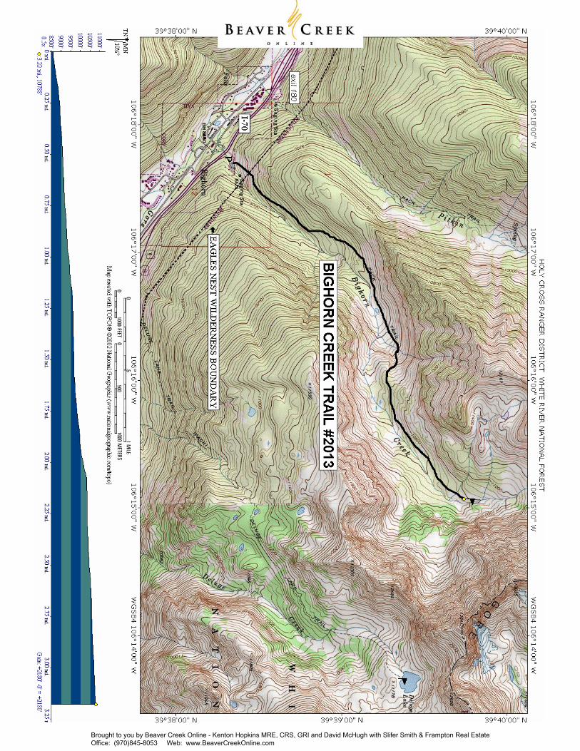
Holy Cross Ranger District 24747 US Hwy 24 P.O. Box 190 Minturn, CO 81645 (970) 827- 5715 - Voice (970) 827-9343 - Fax Access from Vail: Travel east on I-70 to exit 180, exit here and turn right onto the south frontage road. Proceed 1 mile to Columbine Drive, turn left. Continue to the end of the pavement as the road passes under the interstate through a narrow passage. There is limited parking at the end of the road. United States Department of Agriculture Length: 3.25 miles (one way)TRANSCRIPT
Length: 3.25 miles (one way) Trail Use: High Difficulty: More Difficult Open To: Hiking, Horseback Beginning Elevation: 8,608 ft. Ending Elevation: 10,788 ft. Elevation Gain: +2,180 ft.-0 ft. = +2,180 ft. USGS Map(s): Vail East Access from Vail: Travel east on I-70 to exit 180, exit here and turn right onto the south frontage road. Proceed 1 mile to Columbine Drive, turn left. Continue to the end of the pavement as the road passes under the interstate through a narrow passage. There is limited parking at the end of the road. Trail Highlights: The first 1/2 mile of the trail climbs steeply out of the Vail Valley, then more gradually climbs up through stands of aspen and pine. The trail passes beaver ponds and the remains of old mining camps as well as Bighorn Falls. Near mile 2, the views of Vail and Bighorn drainage are exceptional. Around mile 3, the trail passes through open meadows and stands of subalpine fir and Englemann spruce, offering a chance to see the Grand Traverse, a continuous 12,000 foot ridge connecting all the peaks and high drainages of the Gore Range. The trail ends at an old homestead cabin located on private property. Attractions: The Bighorn Creek Trail is less steep than the other East Vail trails. It is generally a fairly easy walk. Just before mile 2 and past a large fern grove, there is a side trail to an overlook down the steep drop to Bighorn Creek. This point makes a good destination for short hikes. The cabin is unlocked to offer shelter for hikers. Please respect this private property and help protect it for others to use and enjoy. Important Information: Bighorn Creek is in the Eagles Nest Wilderness. Wilderness is for your use and enjoyment, but you have an obligation to leave it unimpaired for future generations. Please understand your responsibilities when visiting these special places. Leave them as you wish to find them: * Camping - camp at least 100 feet from streams, lakes, and trails * Dogs - must be leashed out of consideration for both other people and wildlife * Fire - campstoves are recommended and fires are prohibited at and above timberline * Group size - limit group sizes to 15 people * Sanitation - bury human waste 100 feet from water and 6 inches in the soil
PACK IT IN - PACK IT OUT!! LEAVE NO TRACE!!
BIGHORN CREEK TRAIL #2013
Holy Cross Ranger District 24747 US Hwy 24 P.O. Box 190 Minturn, CO 81645 (970) 827- 5715 - Voice (970) 827-9343 - Fax
United States Department of Agriculture HIKING
This map is intended for use as a general guide only, not for actual land navigation. The White River National Forest strongly suggests purchasing a topographic map and compass prior to your hiking trip.
Brought to you by Beaver Creek Online - Kenton Hopkins MRE, CRS, GRI and David McHugh with Slifer Smith & Frampton Real Estate Office: (970)845-8053 Web: www.BeaverCreekOnline.com
Brought to you by Beaver Creek Online - Kenton Hopkins MRE, CRS, GRI and David McHugh with Slifer Smith & Frampton Real Estate Office: (970)845-8053 Web: www.BeaverCreekOnline.com