mesdt resource manual - static.mars.asu.edu mars education program brian ... claudius ptolemy, a...
TRANSCRIPT


SG4
RESOURCE MANUALMESDT
Written and Developed by:
Keith WattASU Mars Education Program
Brian GrigsbyAssistant Director
ASU Mars Education Program
Editing by:
Sheri KlugDirector
ASU Mars Education Program
Paige Valderrama GraffAssistant Director
ASU Mars Education Program
graphics by:
Chris CapagesASU Mars Space Flight Facility
© 2002 ASU Mars Education Program. All rights reserved. This document may be freely distributed for non-commercial use only.

�
RESOURCE MANUALMESDT
Mars has always played a significant role in human society. The early Greeks noted that unlike the other planets, Mars sometimes seemed to reverse its direction across the sky. This “contrary” motion suggested disorder and anarchy to the Greeks, which, along with its reddish color, led them to name the planet after Ares, their god of war. The Romans later changed the planet’s name to that of their god of war, Mars, and the name has remained ever since.
In the BeginningScience and our view of the world change only when we are presented with some observation we can’t explain. Early Greek scientist-philosophers believed that Earth was at the center of the Universe and all other celestial bodies revolved around it. Eudoxus, a mathematician who lived in the fourth century B.C., was one of the first people to propose this theory. Eudoxus’ version of the theory was elegantly simple: God is perfect, the only perfect forms are circles, therefore the Sun and planets must move in circles around the Earth. Claudius Ptolemy, a Greek scholar who lived in Alexandria, Egypt, around 140 AD noted that there were some problems with the theory, however. Careful observations showed that the planets did not quite move in perfect circles. Faced with an observation that couldn’t be explained with current theories, Ptolemy modified Eudoxus’ theory and replaced
his simple circles with a complicated system of “epicycles”, circles that interlock like gears in a complex machine. Ptolemy’s theory could describe and predict the motions of the planets with an accuracy never before achieved. For almost 1,400 years, until the 16th century, Ptolemy’s theory was considered to be the only correct theory of the Universe. The theory was endorsed by the Catholic Church, which declared any other explanation for the planets’ motions to be heresy and punishable by death.
Ptolemy’s theory only had one problem: it was wrong. One hundred years after Eudoxus, the astronomer Aristarchus watched the shadow of the Earth sweep across the surface of the Moon during a lunar eclipse. His observations showed that the Sun had to be much larger than the Earth, and he felt that it was not likely that a large Sun would rotate around the smaller Earth. He proposed instead that the Earth revolves around the Sun. He was condemned for heresy because of his theory and all of his writings were rounded up and destroyed. The only reason we know anything about Aristarchus at all is because he is mentioned in the writings of the great mathematician Archimedes. No other scientist was willing to risk the wrath of the Church by mentioning the astronomer’s work. In 1543, nearly 2,000 years later, however, Aristarchus’ theory was taken up by Polish doctor, lawyer, and part-time astronomer Nicolaus Copernicus. Copernicus’ careful observations could not be explained by Ptolemy’s theory. Only if the Sun were at the center of the Solar System could his data make sense. Once again, because of new observations, new science and a new worldview was born.
The New ScientistsMars played a major role in the controversy. Even Copernicus’ theory could not explain the strange motions of Mars. In 1600 Tycho Brahe had undertaken the careful study of Mars’ orbit. Tycho was perhaps the greatest observational astronomer the world has ever known. We can make more accurate observations today only
Chapter 1: Mars in Society and Culture
The Ptolemaic UniverseCredit: University of Tennessee

�
RESOURCE MANUALMESDT
because we have more accurate instruments. Tycho was world famous, a rock star of science who toured the palaces of kings and other nobility all over Europe. Tycho had given his student, a German mathematician named Johannes Kepler, the task of creating a mathematical description of Mars’ orbit. Tycho, however, was very protective of his data, as are many scientists today. He would throw out an observation over dinner in casual conversation, which Kepler would frantically scrawl down in a notebook that he kept under the table. When Tycho finally died several years later, Kepler broke into Tycho’s safe and stole all of his data. Tycho’s family demanded the documents be returned, and Kepler did so – but only after he had made exact copies of all of the precious data. Kepler, like most of his fellow scientists, felt certain that the planets traveled in perfect circles. After years of struggling with Tycho’s observations of Mars, however, he finally reached the inescapable conclusion that all the work done before him was wrong: the planets move in ellipses, not circles. In addition, he discovered
two other laws of planetary motion that he published in 1609. Thanks to Mars, we now understood not only its motion, but the motion of the entire Solar System as well.
In 1634, Kepler published a book called The Dream, in which he described a fanciful flight from the Earth to the Moon. It was one of the first works of science fiction. Science fiction books have spurred generations of people to wonder about the stars and the planets that travel through the heavens. By the end of the 19th century, however, improved telescopes showed that the Moon was a barren, desolate place, a place where no life could possibly exist. Mars, however, was still a fuzzy disk in even the best telescopes. Science fiction authors, scientists, and the imaginations of the general public turned away from the Moon and looked instead to the Red Planet. In 1877, Italian astronomer Giovanni Schiaparelli observed a series of lines that seemed to cross most of the surface of Mars. In his notes, he called these lines canali, an Italian word that means “channels”. American amateur astronomer Percival Lowell, however, translated the word as “canals”, a very similar meaning, but one that has very different implications: “canals” implies intelligence. Lowell believed that Schiaparelli had discovered the engineering works of a dying Martian society desperately trying to bring water from the Martian icecaps to the equatorial lands. Lowell was so excited by the discovery that he had a state-of-the-art observatory built in Flagstaff, AZ, specifically to study Mars. His writings ignited the imagination of generations of people around the world, including great science fiction authors such as Edgar Rice Burroughs (the Barsoom series of 11 novels), Ray Bradbury (The Martian Chronicles), and H.G. Wells (The War of the Worlds). Wells’ work was made even more popular when Orson Welles (no relation to H.G. Wells) and his Mercury Theater on the Air performed the most famous radio play in American history. To celebrate Halloween of 1938, Welles adapted The War of Worlds, a tale of a Martian invasion of the Earth, into a radio broadcast. Story events were presented as “news broadcasts” reporting New York City in flames and unstoppable aliens destroying everything in their paths. Millions of people, who tuned in to the play late, thought the broadcasts were real and fled their homes in terror of the “invasion”. Most had taken to the streets in panic and never heard the play’s end and Welles’ wish for them to have a happy Halloween. NBC issued a public apology the next day; Welles became one of Hollywood’s most successful actors. Mars, and the possibility of life
Johannes Kepler (1571-1630)Credit: University of St Andrews, Scotland
Lowell’s drawing of MarsCredit: The Wanderer Project

�
RESOURCE MANUALMESDT
there, was so firmly ingrained in the minds of the public that no one questioned that the events of that night might not have actually been real. Mars has always had this power over us.
Today scientists know that Mars in its current form probably cannot support life as we know it. Spacecraft sent to Mars have found no trace of Lowell’s “canals” or of his dying civilization. But was Mars always as it is now? Data returned from our Mars spacecraft show us that it almost certainly was not. At some time in the past, Mars was much warmer and wetter than it is today. What happened to Mars? Did it once have life? Where did all the water on Mars go? Could Earth also change as Mars has? These are just a few of the questions scientists hope to answer, important questions that you will also help to answer as you begin your exploration in the Mars Exploration Student Data Teams.

4
RESOURCE MANUALMESDT
As mentioned in Chapter 1, Mars has attracted the attention and imaginations of observers for thousands of years. The first serious observations of the Martian surface were conducted by Schiaparelli in 1877, whose work was expanded upon by Lowell in 1890. Until the dawn of the space age in the early 1960’s, telescopic observations were the only way we could study Mars. Even the best telescopes, however, must still look up through the Earth’s atmosphere in order to see out into space. It’s a lot like trying to watch clouds from the bottom of a swimming pool: the objects are there, but they are fuzzy, wavering, and hard to make out. If we want to conduct serious observations of another planet, we need to go there.
The Mars RaceOn October 4, 1957, the Soviet Union launched Sputnik �, the first man-made object into space. In doing so, they did more than launch a spacecraft, they launched a race that would ultimately end with the United States landing a total of 12 astronauts on the surface of the Moon. While many people are familiar with the Moon Race, not many people realize that there was a “Mars Race” as well. In 1960, the Soviet Union attempted to launch two robotic space probes to Mars. Both exploded at launch. In 1962, however, they successfully launched their Mars � probe and put it on course for the Red Planet. All seemed to be going well until the spacecraft was about halfway to Mars. Suddenly, all contact with the probe was lost. No one has ever determined what happened to the probe, but its loss gave the American team another chance to be the first to Mars.
Thrilled with the success of Mariner �, the first unmanned mission to Venus, NASA began its program of Mars exploration, hoping to be the first country to explore Mars as well. Approximately every two years the planets are in just the right position for an Earth-Mars trip that requires the least amount of fuel. In 1964, NASA prepared to launch Mariner � and Mariner 4 to Mars. During the launch of Mariner 3, the spacecraft’s protective launch shroud collapsed, destroying the spacecraft. With only three weeks remaining in the low-fuel launch window, NASA engineers scrambled to get Mariner 4 ready to take the place of its sister spacecraft. On November 28, 1964, Mariner 4 launched successfully and put onto the path to Mars. The Soviet Union was not far behind, however. Two days later, on November 30, they launched Zond � and put it on course to Mars as well. There was now a literal race to the Red Planet. Two spacecraft were headed to Mars. Which would get there first?
The race stayed close for the first months of the trip, but just as Zond 2 reached the point near where Mars 1 vanished, it too lost all communications. NASA engineers joked about a “Great Galactic Ghoul” that ate Mars spacecraft. They stopped laughing when Mariner 4 began having communications difficulties in the same area. Unlike Zond 2, however, Mariner 4 resolved its difficulties and sailed on to Mars. On July 15, 1965, Mariner 4 became the first spacecraft to visit Mars. The spacecraft returned 21 images that revealed the dry, cratered surface of Mars. Dreams of a garden planet were laid to rest forever, but the data showed that Mars was a fascinating planet in its own right.
Chapter 2: Mars Exploration Background
SputnikCredit: NASA
Mariner 4Credit: NASA/JPL
ZondCredit: Lunar and Planetary Institute

�
RESOURCE MANUALMESDT
Missions to Mars continued with Mariner 6 and Mariner 7 in 1969, both performing flyby missions similar to Mariner 4. Mariner 6 performed flawlessly, but Mariner 7, during its mission, suddenly lost contact with Earth. Engineers were afraid the “ghoul” had returned, but they managed to re-establish contact and determined that a battery on board had exploded during the pass behind the planet. The controllers instructed Mariner 7 to shut down its damaged systems and continue the mission. The two spacecraft together returned 58 pictures of the Martian surface taken from a distance half as far from the planet as Mariner 4. The images, and particularly those from Mariner 7’s flight over the Martian polar caps, once again changed the way we view Mars. Mariner 7 carried an infrared spectrometer on board that was able to analyze the composition of the ice. The spacecraft discovered that the south polar cap of Mars is not water ice at all, but is instead composed almost entirely of frozen carbon dioxide, or “dry ice”.
Mariner 9NASA engineers quickly realized that in order to carefully study a planet, you have to not only go there, you have to stay. What was needed was a spacecraft that would travel to Mars and place itself in orbit around the planet. The United States was not alone in this assessment. The Soviet Union designed three spacecraft that would travel to Mars during the next launch window. In 1971 they were to join the American Mariner 8 and Mariner 9 probes on the long journey to the Red Planet. The Soviets, however, were attempting to leapfrog the United States: each of their spacecraft contained not only an orbiter, but also a lander designed to descend and send back the first pictures from the surface of Mars. The American Mariner 8 spacecraft died when the second stage of its Atlas-Centaur booster rocket failed to ignite. The Soviet Cosmos 4�9 made it into space, but never left Earth orbit
because the ignition timer for its last stage had been mistakenly set for 1.5 years rather than 1.5 hours after launch. The fleet of spacecraft headed to Mars had been reduced from five to three in just a few weeks.
The three remaining craft, the Soviet Mars � and Mars � and the American Mariner 9, were all launched in May of 1971. Once again, the race to Mars was on. The race was won by Mariner 9, which was on a slightly faster course than its Soviet counterparts. On November 14, 1971, Mariner 9 became the first artificial satellite of another planet. Mars 2 arrived two weeks later and Mars 3 shortly after that. Unfortunately, when the three spacecraft arrived at Mars, there was nothing much to see. In September of 1971 a dust storm, visible from Earth, began which eventually covered the entire planet. Nothing of this scale had ever been observed on any planetary body. The Soviet Mars 2 dispatched its lander anyway, as it programmed to do, but the lander crashed on the surface, sending back no data. Mars 3’s lander faired a bit better, sending back a few seconds of data before it was blown over and destroyed by the raging Martian winds. Still, the Soviet Union had become the first nation to land a spacecraft on another planet – even if it didn’t do much once it got there. The Soviet orbiters snapped featureless pictures of the dust-enshrouded planet until their batteries died. Nothing could be seen through the dust on any of the images. Mariner 9, however, had been designed with an on-board computer that could be reprogrammed from Earth. NASA controllers instructed the spacecraft to shut itself down and conserve power until the storm passed. By December of 1971, the storm was over and NASA woke up the sleeping spacecraft, which returned the highest resolution pictures of Mars that had ever been obtained.
Mariner image of cratered area on MarsCredit: NASA

6
RESOURCE MANUALMESDT
Once again, new observations completely changed everything we thought we once knew. Observations of Mars by previous spacecraft had led us to believe the surface of Mars was a cratered, dead landscape, not much different from Mercury or the Moon. All of those spacecraft, however, had flown past only the southern hemisphere of Mars. The northern hemisphere of Mars is made up of smooth plains and lava basins, totally unlike the cratered south.
Mariner 9 also solved the mystery of the “seasonal variations” Mars seems to display. These dark areas on the surface seem to change location with the seasons and were thought to be indications of plant life growing during the warmer Martian summers. Mariner 9 found that the dark areas were just huge areas of dark rock exposed when the bright red Martian dust was blown away by surface winds. As the seasons changed, so did the direction of the winds, uncovering new dark regions. The three previous Mariner spacecraft sent to Mars had shown no indication of volcanic activity. Mariner 9 discovered Olympus Mons, the largest volcano in the Solar System, and the three Tharsis Montes volcanoes, each larger than any volcano on Earth. The spacecraft also discovered Valles Marineris, the largest canyon system
in the Solar System, formed when some cataclysmic event caused the crust of Mars to bulge so much it cracked. The canyon is so huge, if placed on the Earth it would extend from San Francisco to Washington, D.C. The entire Grand Canyon would fit in one of its side canyons. Most significantly, Mariner 9 discovered long channels that look unmistakably like dry riverbeds – indicating that Mars may have once had liquid water. These and other wonders were returned to Earth in the 7,329 images sent back to Earth during the course of Mariner 9’s year-long mission. The spacecraft ran out of fuel on October 27, 1972, and went forever silent.
The Viking MissionsNASA missed the next launch window in 1973 because it was preparing for an even more ambitious mission: a large-scale lander that would carry a complete laboratory to the surface of Mars. The Soviet Union was not idle, however, using the 1973 launch opportunity to send four spacecraft to the Red Planet. None were successful. By 1975, the American Viking � and Viking � spacecraft were launched and headed to Mars. Like their Soviet counterparts, each Viking spacecraft carried both an orbiter and a lander. The landers carried no less than 14 different experiments, most of which were designed to detect life on the surface. The trouble was that no two scientists agreed upon a definition of life, much less the means
to test for it. Both landers touched down safely, Viking 1 on July 20, 1976, and Viking 2 on September 3, 1976. The landers immediately began the tests for life that were finally worked out as the best that could be done. The experiments initially caused great excitement when they indicated they might have actually found biological activity in the Martian soil. Later analysis of the results, however, indicated that the excitement was misplaced. Today, most scientists believe that the Viking experiments did not in fact detect life on Mars. The question still remains, however: even if there is no life on Mars now, did life ever exist there in its past? The question is still unanswered.
Viking orbiterCredit: NASA/JPL
Viking landerCredit: NASA
Valles Marineris OverlayCredit: NASA/JPL

7
RESOURCE MANUALMESDT
With the end of the Apollo lunar program, NASA’s shrinking budget forced it to concentrate on the Shuttle Transportation System, better known as the Space Shuttle. As a result no American spacecraft visited Mars for nearly twenty years. The Soviet Union (which would simply become Russia the following year) launched Phobos � and � in 1988 to study the moons of Mars, but the “Great Galactic Ghoul” struck once again: Phobos 1 was lost en route to Mars just one month after launch. Phobos 2 arrived near Mars and managed to perform, among other things, important studies of the solar wind near Mars before a computer failure caused controllers to lose contact with the spacecraft just before reaching its destination. Neither mission was counted as a success.
In 1992, the United States decided to return to the Red Planet and renew its studies of this fascinating world. As with the Russian spacecraft, Mars Observer lost contact with Earth a year later just as it was about to enter orbit around Mars. The Mars Observer mission cost nearly one billion dollars. It would be the last of the “old-style” planetary explorers.
Faster, Better, CheaperUnder the leadership of its new administrator, industrialist Dan Goldin, NASA decided to try a new approach dubbed “faster, better, cheaper”. The idea was to use many, smaller spacecraft, instead of one huge expensive spacecraft. In this way, the loss of one craft would not doom an entire exploratory mission. The first in this series of “Discovery missions” was Mars Pathfinder. In contrast to the billion-dollar Mars Observer mission, Pathfinder was designed, built and launched for only 250 million dollars, one-fourth the cost of Observer. Like Viking, Pathfinder included a lander, but it also included something never before attempted: an independent rover, named Sojourner, capable of traveling up to ten meters (32 feet) away from the lander. The mission tested a number of new
technologies. Instead of using a Viking-style retrorocket, the Pathfinder lander was encased in four large six-chambered air bags. Upon entering the Martian atmosphere, the lander parachuted most of the way to the surface, then deployed and inflated its air bags for landing. The spacecraft bounced 15 to 20 times, sometimes as high as 50 feet. The landing went exactly as planned. On July 4, 1997, Pathfinder opened its landing petals, and began its science mission while sending the Sojourner rover on its way. The mission was a complete success. The lander returned over 16,500 images, some in 3D. The rover returned over 550 images but, more importantly, sent back over 15 chemical analyses of rocks and soil, as well as data on Martian winds and weather. On September 27, 1997, the Pathfinder lander, now called Sagan Memorial Station, failed to answer a routine status check. Controllers tried for several months to reach the silent craft, but finally gave up on March 10, 1998, officially ending one of the most successful Mars missions in history.
Although launched a month earlier than Mars Pathfinder, an orbiter called Mars Global Surveyor actually arrived at Mars after Pathfinder. Mars Global Surveyor was designed to use a technique called “aerobraking”, in which the
Mockup of PhobosCredit: High Energy Astrophysics Science Archive Research Center
Pathfinder Lander and RoverCredit: NASA/JPL

8
RESOURCE MANUALMESDT
spacecraft dips into the Martian atmosphere to slow down and place itself in Mars orbit. Aerobraking is a delicate maneuver. If the spacecraft enters too low into the atmosphere, it will burn up. The spacecraft spent almost a year and half slowly modifying its orbit around Mars until it was in a nearly circular polar orbit. This orbit would allow Global Surveyor to image virtually the entire planet during the course of its two-year science mission, which began in March of 1999. Like Pathfinder, Global Surveyor has been a phenomenal success, returning more data about the Martian surface and atmosphere than all previous Mars missions combined. The spacecraft carried not only a camera (the Mars Orbiter Camera, or MOC), it also carried an infrared spectrometer (the Thermal Emission Spectrometer, or TES) designed to search for minerals and measure the temperature of Mars, as well a laser altimeter (the Mars Orbiter Laser Altimeter, or MOLA) which provided the first accurate measurement of the topography – terrain heights – of Mars. The spacecraft completed its primary mapping mission on January 31, 2001, but was in such good health, mission managers decided to extend the mission and to continue gathering data. It was fortunate that they did so, as on June 15, 2001, Global Surveyor scientists detected the beginnings of what would become the largest global dust storm since the Mariner 9 mission almost exactly thirty years prior.
Flush from the successes of Mars Pathfinder and Global Surveyor, NASA commissioned two more spacecraft for the 1998-99 launch window. Mars Climate Orbiter was to function as a Martian weather satellite and as a communications relay satellite for the other craft, Mars Polar Lander. Polar Lander was to land near the south polar ice cap of Mars and dig under the surface in search of water ice. It also carried two “penetrators”, called Deep Space � (Deep Space 1 was a probe designed to study comets using an experimental ion propulsion unit). Unfortunately, Climate Orbiter suffered from human-caused failure, similar to that which struck the Soviet Cosmos 419 in 1971. Navigation parameters were fed to the spacecraft in English units, when the program was
designed to use metric units. The spacecraft disappeared behind Mars on September 23, 1999, and never reappeared. The fate of Polar Lander is still unknown. The spacecraft seemed to be functioning normally as it entered the Martian atmosphere, but no signal from the surface was ever received. Theories include that Polar Lander burned up on entry, crashed into the surface, or perhaps it simply landed in rough terrain and was unable to point its antenna at Earth. This last theory is particularly ironic: the spacecraft could have been completely healthy, it just needed someone to kick it back upright. Strangely, though, nothing was heard from the Deep Space 2 penetrators either, even though they were deployed early in Polar Lander’s descent. We may never know what happened to Mars Polar Lander – at least not until we are able to go there and look at the crash site ourselves.
Mars Global SurveyorCredit: NASA/JPL
Mars Polar LanderCredit: NASA/JPL

9
RESOURCE MANUALMESDT
Chapter 3: Mars in the Solar System
Mars is a world of puzzles. It is both very similar to and very different from our own Earth. Mars is the fourth planet from the Sun and orbits at a distance one and a half times that of Earth’s orbit. As a result, Mars receives much less light and heat from the Sun than the Earth does, so it is much colder. Also, unlike the Earth, Mars has a very thin low-pressure atmosphere which is unable to retain what heat it does receive. Because of the temperatures and pressures on the Martian surface today, water cannot exist in liquid form. Mars today is therefore a dry, frozen desert.
Similarities and DifferencesMars is similar to Earth in a number of important ways. It has an axial tilt of 23.98 degrees, very similiar to Earth’s 23.44 degrees. Mars therefore has seasons, just like Earth, with cold winters and warmer summers. Mars’ rotation period, its “day”, is 24 hours, 37 minutes, again almost exactly the same as Earth’s. Like Earth, Mars has ice caps at both poles. It has clouds, winds, weather, dust storms, volcanoes, and channels. For many years, Venus was considered the “twin” of Earth. Unlike Mars, Venus is very similar in size and mass as Earth and therefore has very similar gravity. But Venus is a hothouse, with temperatures soaring to hundreds of degrees centigrade and atmospheric pressures high
enough to crush our toughest metals like tin cans. Mars, on the other hand, could one day conceivably be changed to be more like Earth through advanced engineering known as “terraforming”. In many respects, Mars is a much more hospitable environment than Venus, making it an obvious target for our imaginations.
But Mars is very different from Earth as well. Surface temperatures on Mars range from hundreds of degrees centigrade below zero in the winter to nearly freezing (0º C) in the summer. Because Earth’s orbit is nearly circular, our seasons are virtually the same in both hemispheres. Mars travels in a more elliptical orbit around the Sun than does the other planets, so it is 20% closer to the Sun during southern summer than it is in northern summer. This results in very long, relatively warm southern summers and very long, cold northern winters. Mars has an atmospheric pressure less than seven-tenths of one percent of Earth’s, far too low to sustain most forms of life as we know it. The southern ice cap is made mostly of frozen carbon dioxide (“dry ice”), not water. Much of the surface of Mars is covered with craters much like the Moon. All of these differences make Mars a world unto itself, rather than a “twin” of Earth or another planet.
The northern and southern hemispheres of Mars are very different. In general, the south is very heavily cratered, while the north is made up mainly of smooth dark plains. There are many exceptions to this general rule, for example, Hellas Planitia (planitia are smooth, low plains or basins) lies in the southern hemisphere and, at 3 km below “datum”, is the deepest basin on Mars. The word “datum” is used rather than “sea level”, because, obviously, Mars currently has no seas! The datum is defined as the altitude at which the atmospheric pressure is 6.1 millibars (6.1 thousandths of the sea level pressure on Earth). The planet isn’t spherical either. There is a very large bulge in the crust located at around 113º west longitude. This region, called the Tharsis Bulge, is home to the largest volcanoes on Mars – and in the entire Solar System. The southern hemisphere reveals the ancient cratering record of impacts early in the Solar System’s history. On Earth, this record has been virtually erased by the effects of volcanoes, wind, and water. Planets such as Mercury died young, ceasing geological activity not long after the
Earth/Mars ComparisonCredit: NASA/JPL

�0
RESOURCE MANUALMESDT
period of major impacts. Mars, however, was geologically active for most of the life of the Solar System – the great volcano Olympus Mons was probably active just thirty million years ago – so has examples of young terrain in the north right alongside the ancient cratered terrain in the south. In many ways, Mars uniquely records the history of the Solar System in its surface features.
Polar CapsThe polar caps of Mars change dramatically over the course of a Martian year (which is almost two Earth years). During each hemisphere’s winter, carbon dioxide freezes out of the atmosphere at the poles to form “dry ice”. This dry ice causes the polar cap in that hemisphere to grow by a substantial amount. As much as one-third of the atmosphere of Mars freezes into dry ice at each pole during winter in its hemisphere. Changes of this magnitude in the atmospheric pressure of the Earth would signal that a storm of unprecedented power was forming, but on Mars it is just a part of the yearly cycle. In the summer, the temperature rises above the vapor point of carbon dioxide and therefore the dry ice sublimates back into the atmosphere. The polar cap then begins to shrink, though there is always some ice left at the poles. The two poles are not the same, however. The ice that remains at the north pole during the northern hemisphere’s summer is mostly water ice, while the residual ice at the south pole is still mostly carbon dioxide ice. Scientists assume that there is water ice buried below the dry ice at the south pole. Mars Polar Lander was intended to resolve this particular question once and for all (but unfortunately did not).
CratersAs with Earth and the Moon, Mars was bombarded with debris left over from the formation of the Solar System. The craters left behind have many of the same properties as those on the Moon: a nearly circular raised rim, steep walls, and a smooth floor. If the debris hit with enough energy to liquefy the surface at impact, a central peak often formed in the center of the crater floor. Ejecta, material blasted into the air from the impact, fell in a blanket that extends outward from the crater. Unlike the Moon, however, ejecta blankets on Mars do not have a perfectly circular form. Many craters have irregular ejecta blankets that seem to indicate that some of the ejecta flowed across the surface outside of the crater rather than simply falling straight back to the surface. Craters of this type are called rampart craters because the ejecta is made up of sheets that have distinct outer ridges, or ramparts.

��
RESOURCE MANUALMESDT
Another unique type of crater on Mars is the pedestal crater. This type of crater is found largely in the northern hemisphere. Craters of this type seem to sit upon a raised pedestal of ejecta. Some of these craters also show ridges like rampart craters, but in other cases the ridges have been eroded away by wind. In some cases the pedestal crater looks to be situated atop a flat, raised plateau which rises above the surrounding terrain.
Any of these types, including the more “standard” lunar-type crater can be made into an incomplete circle by lava flows covering part of the rim. These flooded craters are particularly common near the Tharsis Montes volcanoes.
Wind FeaturesAlthough Mars has a very low atmospheric pressure, the surface winds are very fast. Wind effects are responsible for many of the features that are seen on Mars today. Sand dunes, very similar to those seen on Earth, are abundant in the northern hemisphere. These dunes form in broad lines that run perpendicular to the wind direction. By tracking these dunes, we gain some idea of how the Martian winds flow over time. The wind is also responsible for eroding the Martian landscape, often in strange and bizarre shapes. The wind is strong enough to blow the red dust away to expose darker-colored rock below, an effect which, as mentioned in Chapter 2, once convinced scientists that Mars was covered with vegetation.
VolcanoesMars has the largest volcanoes in the Solar System. One theory why this is true is that Mars seems to have a much thicker crust than Earth, and so it doesn’t have floating, moving crustal plates. Instead of lots of comparatively small eruptions, as occurs with volcanoes on Earth, the pressure on Mars built up into major eruptions that always occurred in the same places – the weak points in Mars’ stable crust. One of the most significant features influencing the development of volcanoes, however, is the Tharsis Montes bulge. The bulge is the site of Olympus Mons, the largest volcano in the Solar System, as well as the three Tharsis Montes volcanoes, each larger than any volcano on Earth. Olympus Mons is 22 km (13.75 miles) high and 550 km (343.75 miles) in diameter. If
placed on the surface of the Earth, it would be two and a half times the height of the tallest mountain on Earth (Mt. Everest at 8.85 km or 5.5 miles) and would cover almost the entire state of Arizona! Numerous other volcanoes

��
RESOURCE MANUALMESDT
dot the region as well. These volcanoes were almost certainly formed from lava upwelling through vents in the fractures created by the bulge. No one really knows what formed the bulge. A number of theories have been proposed, but none have yet been proven. Mars has no magnetic field to speak of, so it probably has no molten, liquid core as the Earth does. Some rocks, however, do show “frozen-in” magnetic field lines, which could be evidence that Mars had a strong magnetic field – and therefore a liquid core – in the past. What happened to the core to cause it to solidify? What
formed the Tharsis bulge? These are some of the puzzles that Mars presents to us today.
CanyonsCanyons exist in many places on Mars, but none are as famous as Valles Marineris (“The Valley of the Mariners”, named for the American probes sent to Mars). The largest canyon in the Solar System, Valles Marineris is even visible from Earth. The canyon is not actually a single canyon, but is instead a system of interconnecting canyons. Valles Marineris varies in depth, but reaches a maximum over 7 km (4.37 miles). Individual canyons are as much as 200 km (125 miles) wide. The central section of Valles Marineris is made up of three nearly parallel canyons, having a total width of over 700 km (437.5 miles) and nearly 2,400 km (1,500 miles) in length. The total length of the Valles Marineris system is over 4,000 km (2,500 miles). The canyon is divided into three general parts. In addition to the central section, to the west, near the Tharsis Montes, is an extremely complex system of interlocking canyons called Noctis Labyrinthus. The eastern end of the canyon is a region of chaotic terrain that could be the result of huge floods flowing out of the canyon after it was formed. Unlike most canyons on Earth, Valles Marineris was not formed by flowing water. The canyon is another effect of the Tharsis bulge. One theory is that it was formed by a

��
RESOURCE MANUALMESDT
literal ripping apart of the Martian crust during the event that caused the Tharsis bulge. Another theory proposes that the canyon was formed when magma underneath it was drawn out in the eruptions of the Tharsis Montes. Once again, we have many puzzles, but very few answers.
ChannelsAs mentioned previously, Mars today cannot have liquid water present on its surface. We have ample evidence, however, that Mars did at one time have water flowing across its surface. Much of this evidence is in the form of channels that appear to be the result of water runoff and outflows from flooding. We know some channels were formed by flooding that resulted when large impact craters were formed on the surface. The force of the impact melted the permafrost (a layer of ice that scientists think lies frozen beneath the Martian surface) and caused the resulting water to flow violently away from the crater. This water eventually refroze or evaporated into the atmosphere.
In addition to water-created channels, channels could also have been formed by flowing lava. Channels formed by water and channels formed by lava have very different appearances. The characteristics of the channel (its walls, its floors, whether or not it has tributaries, etc.) also tell us something about how much water was present and how fast it was flowing. The questions of what happened to the water on Mars and what the surface of Mars was like when water flowed across it are the central questions facing Mars scientists today. Our experience on Earth has been that where there is water, there is life. Is the same thing true on Mars?
AtmosphereThe atmosphere of Mars is very thin, but Mars still has weather! The atmosphere is composed of about 95% carbon dioxide, 2.5% nitrogen, and 1.5% argon. The remaining 1% is mostly oxygen, carbon monoxide, and water vapor. We believe that much of the water on Mars is frozen at the poles and under the ground in a layer called “permafrost”, but some of it actually exists as ice-crystal clouds that float in the atmosphere. These clouds don’t look like the fluffy cumulus clouds we see here on Earth, but they can resemble the thin, wispy cirrus clouds we often see high in our atmosphere. Where different air masses come together, cyclones can form on Mars, just as they do on Earth. The most
striking features of the Martian atmosphere, however, are the dust storms, which can grow strong enough to cover the entire planet. In addition to the dust storm of 1971, which blocked Mariner 9’s view of the planet, in 1977 the Viking orbiters observed no fewer than 25 major dust storms, two of which grew to global proportions. In 2001, the Mars Global Surveyor spacecraft was fortunate to witness the formation and growth of the largest dust storm since the 1971 storm. We have learned a great deal about how the surface of Mars and its atmosphere interact as a result of seasonal heating. This is information that we can use here on Earth as we try to understand our weather and its interactions with the surface.

�4
RESOURCE MANUALMESDT
(Note: Much of this material was taken from official NASA sources. We would like to gratefully acknowledge their assistance!)
NASA launched a multipurpose spacecraft named Mars Reconnaissance Orbiter on Aug. 12, 2005 to advance our understanding of Mars through detailed observation, to examine potential landing sites for future surface missions and to provide a high-data-rate communications relay for those missions.
Scientists will use the spacecraft to study the surface, monitor the atmosphere, and probe underground, all to gain better knowledge of the distribution and history of Mars’ water, whether frozen, liquid or vapor.
Carrying the most powerful telescopic camera ever flown to another planet, Mars Reconnaissance Orbiter will be able to show Martian landscape features as small as a kitchen table from the spacecraft’s low orbital altitude. That camera and five other science instruments will produce copious data every day for a planned 24-month science phase. To pour the data back to Earth at more than 10 times the rate of any previous Mars mission, the spacecraft will use a wider antenna dish, a faster computer and an amplifier powered by a bigger solar-cell array.
OverviewMars Reconnaissance Orbiter will seek to find out about the history of water on Mars with its science instruments. They will zoom in for extreme close-up photography of the martian surface, analyze minerals, look for subsurface water, trace how much dust and water are distributed in the atmosphere, and monitor daily global weather.
These studies will help determine if there are deposits of minerals that form in water over long periods of time, detect any shorelines of ancient seas and lakes, and analyze deposits placed in layers over time by flowing water. It will also be able to tell if the underground martian ice discovered by the Mars Odyssey orbiter is the top layer of a deep ice deposit or whether it is a shallow layer in equilibrium with the current atmosphere and its seasonal cycle of water vapor.
In its survey of the red planet, Mars Reconnaissance will increase tenfold the number of spots surveyed close-up. One of the Mars Reconnaissance orbiter’s cameras is the largest ever flown on a planetary mission. While previous cameras on other Mars orbiters could identify objects no smaller than a school bus, this camera will be able to spot something as small as a dinner table. That capability will also allow the orbiter to identify obstacles like large rocks that could jeopardize the safety of future landers and rovers. Its imaging spectrometer will also be able to look at small-scale areas about five times smaller than a football field, at a scale perfect for identifying any hot springs or other small water features.
Chapter 4: Mars Reconnaissance Orbiter
Mars Recconaissance OrbiterCredit: NASA/JPL

��
RESOURCE MANUALMESDT
The orbiter’s telecommunications systems will also establish a crucial service for future spacecraft, becoming the first link in a communications bridge back to Earth, an “interplanetary Internet” that can be used by numerous international spacecraft in the coming years. Testing the use of a radio frequency called Ka-band, Mars Reconnaissance Orbiter may demonstrate the potential for greater performance in communications using significantly less power. The orbiter also carries an experimental navigation camera. If it performs well, similar cameras placed on orbiters of the future would be able to serve as high-precision interplanetary “eyes” to guide incoming landers to precise landings on Mars, opening up exciting-but otherwise dangerous-areas of the planet to exploration.
Launch and Interplanetary Cruise InjectionThe Mars Reconnaissance Orbiter’s mission to Mars began on August 11th, 2005 as the spacecraft roared into space from Space Launch Complex 41 at Cape Canaveral Air Force Station, onboard an Atlas V-401 launch vehicle, the smallest of the Atlas V family. Launch takes place during Earth’s Northern Summer and during Mars’ Northern Winter.
Many people think that when a spacecraft simply lifts off the launch pad on its way to space, but there are several critical steps to a launch before the spacecraft is successfully on its way to Mars:
Step one: Count down and systems check.
Step two: Lift off through stage 1 booster, which accelerates the spacecraft to supersonic speeds of about 10,000 miles per hour.
Step three: After about 4 and minutes, the first stage cuts off.
Step four: The first stage separates from the Centaur stage II and falls back into the Atlantic Ocean.
Stepfive: The Centaur (with the spacecraft still attached) then coasts in the parking orbit until it has reached a point over the Indian Ocean where the Centaur engine fires a second time to accelerate the spacecraft out of Earth orbit and on its way towards Mars. The coast period between the two Centaur burns lasts for about 33 minutes. During this coast period, the Centaur points the orbiter toward the sun and slowly rolls along its axis (like a rotisserie) to control the temperatures on all parts of the Centaur and the spacecraft.

�6
RESOURCE MANUALMESDT
Step six: Jettison of the payload faring. The fairing protects the spacecraft from the weather on the ground as well as from the atmosphere during flight. When the launch vehicle is on the launch pad, the spacecraft is supplied with air conditioning in order to control temperature and to protect it from dust and dirt.
Step seven: Main engine cut off. (A.K.A. “Meco”)
Step eight: Second stage burn which lasts about 10 minutes, and accelerates the spacecraft out of Earth orbit and sends it on its way to Mars. After the second burn (about ten minutes duration), the Centaur automatically releases the clamp band that holds the spacecraft on top
of the Centaur and the spacecraft separates. Separation occurs when the spacecraft is just North West of Australia. After a short period of time for the spacecraft to drift far enough away from the Centaur, the Centaur performs a maneuver to move away from the flight path of the spacecraft. This maneuver is important since, if it were not done, the Centaur would try to follow the spacecraft to Mars and might eventually collide with the spacecraft or impact Mars. As soon as this maneuver is done, the job of the launch vehicle is complete and the spacecraft is on its way to Mars.
Interplanetary CruiseThe spacecraft’s trip from Earth to Mars takes about seven months. The first five months were the cruise phase. Main activities during cruise included checks and calibrations of onboard equipment, daily monitoring of orbiter subsystems, and navigational procedures to determine and correct the vehicle’s flight path.
Cruise-phase work put various systems and scientific instruments into final working order. Antennas, cameras and reaction-control thrusters are aligned and calibrated. Camera checks included imaging of Earth’s moon and the star cluster Omega Centauri. The Electra UHF communications system is tested in a link with a ground station at Stanford, Calif. Other tests assessed electromagnetic interference among spacecraft systems and instruments in
the space environment, and jitter disturbance in high-resolution camera images.
The trip calendar has five scheduled opportunities for trajectory correction maneuvers (A.K.A. “T.C.M.”.) On Aug. 27, 2005 the first and largest of these maneuvers fired the orbiter’s powerful 170-newton thrusters. Until that point, the spacecraft’s flight path had been intentionally biased slightly off-course to prevent the Centaur upper stage from following the spacecraft and hitting Mars. The main thrusters burned for 15 seconds, successfully making the course adjustment calculated by navigators and also providing an operational test of these thrusters in preparation for their main job of slowing the spacecraft into orbit around Mars.

�7
RESOURCE MANUALMESDT
The second trajectory correction maneuver, on Nov. 18, 2005 employed the spacecraft’s intermediate-power, 22-newton thrusters. The intermediate thrusters burned for 19.1 seconds. All the maneuvers, including the first, also use smaller, 0.9-newton thrusters to provide attitude control during the change in velocity.
Calculations for trajectory corrections are based on very accurate determinations of the spacecraft’s position, direction of movement and velocity. The Mars Reconnaissance Orbiter navigators combine two traditional tracking techniques with a newer triangulation method to improve navigational precision. One of the traditional methods is ranging, which measures the distance to the spacecraft by timing precisely how long it takes for a radio signal to travel to the spacecraft and back. The other is Doppler, which mea¬sures the spacecraft’s speed relative to Earth by the amount of shift in the pitch of a radio signal from the craft.
The newer method, called delta differential one-way range measurement, adds information about the location of the spacecraft in directions perpendicular to the line of sight. Pairs of antennas at Deep Space Network sites on two different continents simultaneously receive signals from the spacecraft, and then the same antennas are used to observe natural radio waves from a known celestial reference point, such as a quasar.
Approaching Mars and Entering OrbitOn March 11, 2006, the Mars Reconnaissance Orbiter neared its closest point to the planet to begin what is called Mars Orbit Insertion or MOI. “Mars Orbit insertion” is the point in the mission when Mars Reconnaissance Orbiter arrives just short of Mars, fires onboard rockets to slow its speed relative to the planet, and is captured into a long looping orbit.
As the orbiter approached Mars, it passed under the southern hemisphere at an altitude of about 300 kilometers (190 miles), traveling at about 3 kilometers per second (about 6,500 miles per hour). In order to be captured into orbit around Mars, the spacecraft performed a maneuver to slow the orbiter by about 1000 meters per second (3,280 feet per second). The Mars orbit insertion burn used its six 170-Newton (38-pound) main engines and lasted about 25 minutes.
For most of the burn, the orbiter will be visible from the Deep Space Network stations. However, the signal from the spacecraft will be temporarily lost as the orbiter goes behind Mars. During this period the spacecraft is out of contact with mission control. The mission team holds a collective breath, waiting for the orbiter to appear again approximately 30 minutes later.
The capture orbit at first is highly elliptical. The closest the spacecraft came to Mars in this orbit (the periapsis) was 300 kilometers (180 miles). The farthest away (its apoapsis) was 45,000 kilometers (28,000 miles). During this first orbit, the spacecraft takes about 35 hours to move completely around the capture orbit.
Several activities take place for the first few elongated orbits around Mars. Engineers check the spacecraft’s health and status during the first two orbits. The three cameras from the science payload -- the High Resolution Imaging Science Experiment (HiRISE), the Context Camera (CTX), and the Mars Color Imager – took their first test images of Mars as the orbiter passed low over the southern hemisphere near the end of the third orbit, on March 14, 2006. The following day, the Mars Climate Sounder (MCS) instrument scanned the atmosphere over Mars’ northern hemisphere. This served as a check of that instrument’s capability to aid in planning aerobraking events

�8
RESOURCE MANUALMESDT
by identifying variations in atmospheric density. Late in the fourth orbit, on March 16, a jitter test was conducted to determine whether image quality is affected by operating motors of other instruments at the same time the high-resolution camera is taking an image.
AerobrakingAerobraking begins after Mars Orbit Insertion and a check of spacecraft health and lasts about six months. It is a process that uses the friction of the martian atmosphere to slow the spacecraft down. This reduces the orbit size to be a more suitable orbit for science operations.
Much like the weather on Earth, the upper atmosphere of Mars is somewhat different from day to day and place to place. These variations are difficult to predict. Since the orbiter is flying through this varying atmosphere during aerobraking, operations of the orbiter
are risky for the orbiter and difficult and intense for the operators.
Aerobraking occurs in 3 primary phases:Walk In: This lasts about a week, or 5 orbits. Engineers command the spacecraft to lower the periapsis (the closest point to Mars in its orbit) one orbit at a time, taking the spacecraft from its Mars Orbit Insertion (MOI) altitude to its aerobraking altitude. This phase is used as a calibration period to understand atmospheric densities and the way in which the orbiter behaves in and out of aerobraking.
Main Phase: Lasts about 5 ½ months and fewer than 500 orbits. Once the orbiter has reached its operational altitude (where the desired atmospheric densities are found), the main phase of aerobraking begins. Engineers will command the orbiter to make large-scale reductions in its orbit. If the altitude gets too low, the spacecraft will be in danger of overheating, if the altitude gets too high, then aerobraking will finish too late. Therefore, small propulsive maneuvers are occasionally required to keep the orbiter within a specified “corridor” by raising or lowering its periapsis altitude.
Walk Out: Lasts about 5 days, or 64 orbits. The walk-out phase occurs during the last few days of aerobraking. Engineers will command the orbiter to increase its periapsis (the closest point it comes to Mars in its orbit), causing the orbit to shrink more slowly. When the apoapsis (the farthest away from Mars that the spacecraft gets in its orbit) has been reduced to 450 kilometers (280 miles), the periapsis will be raised out of the atmosphere and aerobraking will be complete.
Post-aerobrakingThere is also a post-aerobraking phase that takes place prior to the science operations phase:

�9
RESOURCE MANUALMESDT
Orbit Trim Maneuvers: Lasts about 2 weeks. When aerobraking is complete, the orbiter will perform 3 small orbit trim maneuvers (OTMs) to place itself in the primary science orbit.
Spacecraft and instrument checks: Lasts through solar conjunction, which occurs between October 7 and November 8, 2006. Science operations cannot begin until after solar conjunction, when the sun comes between Earth and Mars and communications are limited by solar interference. During that time the orbiter will remain in a safe and quiet operational mode. On Earth, however, engineers will configure the orbiter. Instruments will be powered on, configured, checked out, and calibrated to be ready for the collection of science data. Instrument deployments such as the SHARAD (Shallow Radar) antenna deployment and the CRISM (Compact Reconnaissance Imaging Spectrometer for Mars) cover release will occur in this period. Initial observations of the surface will be made by all instruments to verify observing modes, image quality, and processing performance.
Science OperationsThe primary science phase begins when the orbiter is delivered into its science orbit and its instruments and other systems are checked out, calibrated and ready for the collection of science data. The primary science phase lasts for at least one Mars year (about two Earth years), beginning after the end of solar conjunction in November, 2006 and ending with the start of solar conjunction in November, 2008. Solar conjunction is when the sun comes between the Earth and Mars and communications are limited.
For science operations, the orbiter will be in a 255 x 320 kilometer (160 mile x 200 mile) near-polar orbit around Mars.
The periapsis (the closest point the spacecraft comes to Mars in its orbit) will be 255 kilometers (160 miles) above the South Pole of Mars.
Its apoapsis (the farthest point the spacecraft is from Mars in its orbit) will be 320 kilometers (200 miles) above the North Pole of Mars.
The orbit will also be “sun-synchronous,” which means it will twist around Mars at the same rate that Mars moves around the Sun. That
means that every time the orbiter crosses the sun-lit side of Mars from South to North, the ground below will always be at the same time of day-- 3 o’clock in the martian afternoon (when over the equator).

�0
RESOURCE MANUALMESDT
The spacecraft will complete 12 orbits per day. As the spacecraft passes over the martian surface with each orbit, the swath of ground covered directly below is known as the ground track. After 359 days of orbits, the ground tracks cover the surface of Mars in a fine pattern with less than 5 kilometers (3 miles) separation between them. Due to small variations in the gravity field, atmosphere, and orbit control strategy, the fine pattern will not be regular or precise, but will still allow excellent coverage and repeated opportunities to observe particular sites on the martian surface and changes there through time.
During the science operation phase, conducting science observations will be more complex than in previous Mars missions, because Mars Reconnaissance Orbiter must coordinate three basic observation goals:
• Daily global mapping and profiling
• Regional surveys
• Globally distributed targeting of hundreds of specific sites
Many targeted observations will also involve nearly simultaneous, coordinated observations by more than one instrument.
On-board InstrumentsMRO carries six science instruments, three engineering instruments, and two more science-facility experiments.
Science instruments During its two-year primary science mission, the Mars Reconnaissance Orbiter will conduct eight different science investigations at Mars. The investigations are functionally divided into three purposes: global mapping, regional surveying, and high-resolution targeting of specific spots on the surface.
CamerasHiRISE (High Resolution Imaging Science Experiment): This visible camera can reveal small-scale objects in the debris blankets of mysterious gullies and details of geologic structure of canyons, craters, and layered deposits
CTX (Context Camera): This camera will provide wide area views to help provide a context for high-resolution analysis of key spots on Mars provided by HiRISE and CRISM.
��
RESOURCE MANUALMESDT
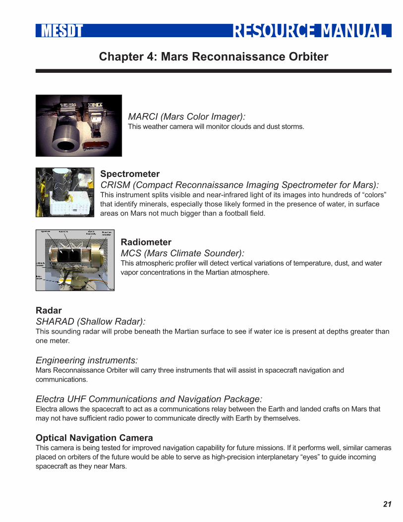
MARCI (Mars Color Imager): This weather camera will monitor clouds and dust storms.
SpectrometerCRISM (Compact Reconnaissance Imaging Spectrometer for Mars): This instrument splits visible and near-infrared light of its images into hundreds of “colors” that identify minerals, especially those likely formed in the presence of water, in surface areas on Mars not much bigger than a football field.
RadiometerMCS (Mars Climate Sounder): This atmospheric profiler will detect vertical variations of temperature, dust, and water vapor concentrations in the Martian atmosphere.
RadarSHARAD (Shallow Radar): This sounding radar will probe beneath the Martian surface to see if water ice is present at depths greater than one meter.
Engineering instruments: Mars Reconnaissance Orbiter will carry three instruments that will assist in spacecraft navigation and communications.
Electra UHF Communications and Navigation Package:Electra allows the spacecraft to act as a communications relay between the Earth and landed crafts on Mars that may not have sufficient radio power to communicate directly with Earth by themselves.
Optical Navigation CameraThis camera is being tested for improved navigation capability for future missions. If it performs well, similar cameras placed on orbiters of the future would be able to serve as high-precision interplanetary “eyes” to guide incoming spacecraft as they near Mars.
Chapter 4: Mars Reconnaissance Orbiter
��
RESOURCE MANUALMESDT
Ka-band Telecommunications Experiment Package Mars Reconnaissance Orbiter will test the use of a radio frequency called Ka-band to demonstrate the potential for greater performance in communications using significantly less power.
Science Facility Experiments: Two additional science investigations will be carried out using engineering data.
Gravity Field Investigation PackageBy tracking the orbiter in the primary science phase, team members will be able to map the gravity field or Mars to understand the geology of the surface and near-surface and the geophysical processes that produce these land features. For example, analysis could reveal how the planet’s mass is redistributed as the Martian polar caps form and dissipate seasonally.
Atmospheric Structure Investigation AccelerometersData will be collected from accelerometers. During aerobraking, the accelerometers will help scientists understand the structure of the Martian atmosphere.
Relay PhaseOnce MRO completes its primary science operations phase, it will provide critical relay support to missions launched as part of the Mars Exploration Program after MRO. For spacecraft launched in 2007, this relay support is likely to occur before the end of the MRO Primary Science Phase. During the Relay Phase, MRO will continue to prove critical relay support for Mars missions until its end of mission on Dec 31, 2010.

��
RESOURCE MANUALMESDT
Of the eleven instruments on board the Mars Reconnaissance Orbiter, the one you will be working with is the Compact Reconnaissance Imaging System for Mars or CRISM. The Johns Hopkins University Applied Physics Laboratory (APL) led the effort to design and build the CRISM instrument. It’s not APL’s first trip to Mars: the Lab also developed ultra-stable oscillators (super-precise timekeeping devices) for three Mars spacecraft, including Mars Global Surveyor, which has mapped atmospheric structure and circulation patterns on Mars for the past five years.
Following the WaterCRISM will search for the residue of minerals that form in the presence of water and might have been left by hot springs, thermal vents, lakes, or ponds on Mars far back in its history when water may have been present on the surface.
Even though certain landforms provide evidence that liquid water may have flowed on the surface of Mars long ago, evidence for the mineral deposits created by long-term interaction with water and rock has been limited.
CRISM’s visible and infrared spectrometers will track regions on the dusty martian surface and map them at scales as small as 18 meters (60 feet) across, from an altitude of 300 kilometers (186 miles). CRISM will read the hundreds of “colors” in reflected sunlight to detect patterns that indicate certain minerals on the surface, including the signature traces of past water.
Everyday you experience infrared radiation every day as heat! Each color that we see in a rainbow actually corresponds to a specific wavelength or frequency. Red light has a very long wavelength, while blue light has a very short wavelength. Infrared light has wavelengths even longer than red light – it’s a color
“redder than red”, a color so red your eye can’t even see it! The range of all wavelengths, which includes the colors that your eye can see, is called the electromagnetic spectrum. The part of the electromagnetic spectrum that your eye can see is actually a very tiny slice called the visible spectrum. The part of the spectrum that we call infrared ranges from the edge of the visible spectrum to the start of the radio portion of the spectrum. Within the visible spectrum there is actually an infinite number of colors, not just the seven we usually give names to. The same is true of the infrared part of the spectrum. The CRISM spectrometer has detectors to view these invisible (to humans) wavelengths, or “colors”, of infrared light. By making maps of the different colors received by CRISM, we can map the minerals on the surface of Mars from orbit.
CRISM is an imaging spectrometer with high spatial resolution. “Imaging with high spatial resolution” means that it can see small details on the surface of the planet. “Spectrometer” means it can measure many wavelengths or colors of light.
Chapter 5: An introduction to CRISM

�4
RESOURCE MANUALMESDT
CRISM can image Mars in two different modes: (1) multispectral mapping mode, and (2) hyperspectral targeting mode. In multispectral mapping mode, the instrument can image the surface at 100-200 meters per pixel. Each “pixel”, or dot that makes up the image, represents an area as small as 100-200 meters (328-656 feet) on each side. Thus, a football field imaged by CRISM would take up just a bit more than one “dot” in the image. For each football-field-sized pixel in multispectral mapping mode, CRISM measures 73 wavelengths of light, many more than the 3 wavelengths (red, green, and blue) that would make up a normal color image. Nearly the entire planet can be mapped at wavelengths that show key mineral locations, which would allow scientists to decide areas on the surface that should be imaged in hyperspectral mode.
In hyperspectral targeting mode, CRISM can resolve features as small as 18 meters (60 feet) across. Which means a school bus would take up roughly one “dot” in the image. For each school-bus-sized pixel in hyperspectral targeting mode, CRISM measures 545 wavelengths of light.
CRISM will use the spectrum of reflected sunlight to determine the mineralogy of the surface - perhaps spotting the mineral fingerprints water may have left behind.
Mission PlanningFlying a spacecraft to Mars cannot be accomplished without a large staff to support it. In the case of MRO, the spacecraft itself is managed by Lockeed Martin Astronautics (LMA) in Denver, CO, under contract to NASA’s Jet Propulsion Laboratory (JPL) in Pasadena, CA. MRO carries MRO carries six science instruments,
three engineering instruments, and two more science-facility experiments, each of which is controlled by a separate team. Each team has its own needs for the spacecraft, and these often conflict with other teams or with the needs of the LMA engineers. Within each instrument team are several science teams, each with different priorities for observations. In addition, orbital factors such as the position of the Sun or Mars’ moons must be taken into account. The mission planner is responsible for looking at the needs of all of these groups and trying to please everyone! In reality this is often an impossible task, but the mission planner tries very hard to make it all fit together.

��
RESOURCE MANUALMESDTKey Words
Aerobraking is a spacecraft maneuver that reduces the high point of an elliptical orbit (apoapsis) by flying the vehicle through the atmosphere at the low point of the orbit (periapsis), using drag to slow the spacecraft. Aerobraking saves fuel, compared to the direct use of a rocket engine, when the spacecraft requires a low orbit after arriving at a body with an atmosphere.
Apsis: the point of greatest or least distance of the elliptical orbit of a celestial body from its center of attraction, which is generally the center of mass of the system.
Apoapsis: the point of farthest excursion of a body around a planet.
Aristarchus: (310 BC - 230 BC): A Greek mathematician and astronomer who is celebrated as the exponent of a Sun-centered universe and for his pioneering attempt to determine the sizes and distances of the Sun and Moon.
Archimedes: (287 BC – 212 BC) Known as the greatest mathematician of his age. His contributions in geometry revolutionized the subject and his methods anticipated the integral calculus 2,000 years before Newton and Leibniz. He was also a thoroughly practical man who invented a wide variety of machines including pulleys and the Archimedean screw pumping device.
Atlas, first tested in 1959, was the United States’ first successful ICBM (Intercontinental Ballistic Missile). It was a “1.5 stage”, liquid-fueled rocket, with three engines producing 1,590 kN of thrust.
Celsius is, or relates to, the Celsius temperature scale. Degrees Celsius (symbol: °C) refers to a specific temperature on the Celsius temperature scale. The degree Celsius is also a unit increment of temperature for use in indicating a temperature interval (a difference between two temperatures or an uncertainty). “Celsius” is named after the Swedish astronomer Anders Celsius (1701 – 1744), who first proposed a similar system two years before his death.
Claudius Ptolemy: (85-165 AD) The most influential of Greek astronomers and geographers of his time. He propounded the geocentric theory that prevailed for 1400 years.
Cosmos 419 was launched by the Soviet Union on May 10, 1971. Mars was at its closest to Earth since 1956, and in May that year both the Soviet Union and the United States made new attempts to reach the Red Planet. Cosmos’ payload however failed to separate from the fourth stage of the launch vehicle, and Cosmos 419 reentered Earth’s atmosphere two days after launch.
Daniel Goldin (born July 23, 1940) served as the 9th Administrator of NASA from April 1, 1992, to November 17, 2001. He was appointed by President George H. W. Bush and served under three presidential administrations.
Deep Space 2: launched in January 1999 as part of NASA’s New Millennium Program, consisted of two highly advanced miniature probes to Mars. They were intended to be the first spacecraft ever to penetrate below

�6
RESOURCE MANUALMESDT
Key Words
the surface of another planet. The Deep Space 2 probes were also the first landers to use only an aeroshell, lacking parachutes or rockets to reduce their impact velocity. They rode to Mars aboard another spacecraft, the Mars Polar Lander. Upon arrival just above the south polar region of Mars on December 3, 1999, the basketball-sized shells were to be released from the main spacecraft, plummeting through the atmosphere and hitting the planet’s surface at over 644 km/h (400 mph). On impact, each shell was designed to shatter and its grapefruit-sized probe was to punch through the soil and separate into two parts. The lower part, called the forebody, would penetrate as far as 0.6 meters (about 2 feet) into the soil; the upper part of the probe, or the aftbody, would stay on the surface to radio data to the Mars Global Surveyor spacecraft in orbit around Mars, which will then send the data to Earth. The two sections of the probe would remain connected via a data cable. The probes reached Mars apparently without incident, but communication was never established after landing. It is not known what the cause of failure was.
NASA’s Discovery Program is a series of lower-cost, highly focused scientific space missions. It was founded to implement NASA Administrator Daniel S. Goldin’s vision of “faster, better, cheaper” planetary missions.
Doppler radar uses the Doppler effect to measure the relative velocity of targets in the antenna’s directional beam. The Doppler effect shifts the received frequency up or down based on the relative velocity of target (closing or opening) in the beam, allowing for the direct and highly accurate measurement of speed.
Edgar Rice Burroughs (1875 – 1950) was an American author, best known for his creation of the jungle hero Tarzan, although he also produced works in many genres
Ellipse: In mathematics, an ellipse (from the Greek for absence) is a curve where the sum of the distances from any point on the curve to two fixed points is constant. The two fixed points are called foci (plural of focus).
Epicycles: In the Ptolemaic system of astronomy, the epicycle (literally: on the cycle in Greek) was a geometric model to explain the variations in speed and direction of the apparent motion of the Moon, Sun, and planets. It was designed by Apollonius of Perga at the end of the 3rd century BC. In particular it explained retrograde motion.
Eudoxus: (408 BC - 355 BC) A Greek mathematician and astronomer who contributed to Euclid’s Elements. He mapped the stars and compiled a map of the known world. His philosophy influenced Aristotle.
Ejecta consists of particles that came out of a volcanic vent, traveled through the air or under water, and fell back on the ground surface or on the ocean floor. Ejecta can consist of:
1. juvenile particles - (fragmented magma and free crystals) 2. cognate or accessory particles - older volcanic rocks from the same volcano 3. accidental particles - derived from the volcanic basement.
George Orson Welles (1915 – 1985) was an American radio broadcaster, theatre director, film director and actor. He gained international notoriety for his October 30, 1938 radio broadcast of H. G. Wells’ The War of the Worlds, which panicked millions of listeners into believing the broadcast was real.

�7
RESOURCE MANUALMESDT
Key Words
Giovanni Schiaparelli (1835 – 1910) was an Italian astronomer. He studied at the University of Turin and Berlin Observatory and worked for over forty years at Brera Observatory. He observed objects in the solar system, and after observing Mars he named the seas and continents. Beginning in 1877 he also believed he had observed long straight features he called canali in Italian, meaning “channels” but famously mistranslated as “canals”. Many decades later these canals of Mars were definitively shown to be an optical illusion.
Hellas Planitia, also known as the Hellas Impact Basin, is a roughly circular impact crater located in the southern hemisphere of the planet Mars. With a diameter of about 2,100 km (1304 Miles), it is the largest impact structure on the planet. The basin is thought to have been formed about 3.9 billion years ago, when a large asteroid impacted Mars.
H.G. (Herbert George) Wells (1866 – 1946) was an English writer best known for such science fiction novels as The Time Machine, The War of the Worlds, The Invisible Man, and The Island of Doctor Moreau. He was a prolific writer of both fiction and non-fiction, and produced works in many different genres, including contemporary novels, history, and social commentary.
Johannes Kepler (1571 – 1630) A German mathematician and astronomer who postulated that the Earth and planets travel about the sun in elliptical orbits. He gave three fundamental laws of planetary motion. He also did important work in optics and geometry.
Mariner 2 was a space probe to Fly by Venus and return data on the planet’s atmosphere, magnetic field, charged particle environment, and mass.
Mariner 3 and 4 were identical spacecraft of the Mariner program designed to carry out the first flybys of Mars. Mariner 3 was launched on November 5, 1964, but the shroud encasing the spacecraft atop its rocket failed to open properly, and Mariner 3 did not get to Mars. Unable to collect the Sun’s energy for power from its solar panels, the probe soon died when its batteries ran out and is now in solar orbit. Three weeks later, on November 28, 1964, Mariner 4 was launched successfully on an eight-month voyage to the red planet.
Mariner 6 and Mariner 7 (1969) completed the first dual mission to Mars, flying over the equator and south polar regions and analyzing atmosphere and surface with remote sensors as well as recording and relaying hundreds of pictures. By chance, both flew over cratered regions and missed both the giant northern volcanoes and the equatorial Grand Canyon discovered later. Their approach pictures did, however, photograph about 20% of the planet’s surface, showing the dark features long seen from Earth, but none of the canals mistakenly observed by ground-based astronomers. In total 198 photos were taken and transmitted back to earth, adding more detail than the earlier mission, Mariner 4. Both craft also studied the atmosphere of Mars.
Mariner 8 was launched on an Atlas-Centaur SLV-3C booster (AC-24). The main Centaur engine was ignited 265 seconds after launch, but the upper stage began to oscillate in pitch and tumbled out of control. The Centaur stage shut down 365 seconds after launch due to starvation caused by the tumbling. The Centaur and spacecraft payload separated and re-entered the Earth’s atmosphere approximately 1500 km downrange and fell into the Atlantic Ocean about 560 km north of Puerto Rico.

�8
RESOURCE MANUALMESDT
Key Words
Mariner 9 was designed to continue the atmospheric studies begun by Mariner 6 and 7, and to map over 70% of the Martian surface from the lowest altitude (1500 kilometers [about 900 miles]) and at the highest resolutions (1 kilometer per pixel to 100 meters per pixel) of any previous Mars mission. An infrared radiometer was included to detect heat sources as evidence of volcanic activity. Mars’ two moons were also to be analyzed.
Mars 1 (1962 Beta Nu 1) was an automatic interplanetary station launched in the direction of Mars on November 1, 1962, the first of the Soviet Mars probe program, with the intent of flying by the planet at a distance of about 11,000 km. It was designed to image the surface and send back data on cosmic radiation, micrometeoroid impacts and Mars’ magnetic field, radiation environment, atmospheric structure, and possible organic compounds.
Mars 2 and Mars 3 missions consisted of identical spacecraft, each with an orbiter and an attached lander; they were the first human artifacts to touch down on Mars. They were launched by Tyazheliy Sputniks.
Mars Climate Orbiter: The Mars Climate Orbiter (1998) was destroyed when a navigation error caused the spacecraft to miss its intended 140–150 km altitude above Mars during orbit insertion, instead entering the Martian atmosphere at about 57 km. The spacecraft was destroyed by atmospheric stresses and friction at this low altitude.
The Mars Global Surveyor (MGS) is a US spacecraft developed by NASA and the Jet Propulsion Laboratory and launched November 1996. It began the United States return to Mars after a 20-year absence. It completed its primary mission in January 2001.
Mars Orbiter Camera (MOC): This camera produces a daily wide-angle image of Mars similar to weather photographs of the Earth, and takes narrow angle images.
Mars Orbiting Laser Altimeter (MOLA): This experiment measured the height of Martian surface features like mountains and depths of valleys.
Mars Observer, launched by NASA in September 25, 1992, was the first of the proposed Observer series of planetary missions, and was designed to study the geoscience and climate of Mars. Contact with the spacecraft was lost three days before scheduled orbit insertion and was never re-established.
The MarsPathfinder was launched on December 4, 1996 by NASA aboard a Delta II rocket; just a month after the Mars Global Surveyor was launched. After a 7-month voyage it landed on Ares Vallis, in a region called Chryse Planitia on Mars, on 4 July 1997. The mission carried a series of different scientific instruments to analyze the Martian atmosphere, climate, geology and the composition of its rocks and soil.
Mars Polar Lander: The Mars Polar Lander (1998) was to touch down on the southern polar layered terrain, between 73°S and 76°S in a region called Planum Australe, less than 1000 km from the south pole, near the edge of the carbon dioxide ice cap in Mars’ late southern spring. Communication with the lander was lost prior to atmospheric entry.

�9
RESOURCE MANUALMESDT
Key Words
Mars Reconnaissance Orbiter (MRO) is a multipurpose spacecraft designed to conduct reconnaissance and exploration of Mars from orbit. MRO contains a host of scientific instruments such as Cameras, Spectrometers, and RADAR, which will be used to analyze the landforms, stratigraphy, minerals, and ice of Mars. It will pave the way for future spacecraft by monitoring daily weather and surface conditions, studying potential landing sites, and testing a new telecommunications system. MRO’s telecommunications system will transfer more data back to Earth than all previous interplanetary missions combined, and MRO will serve as a highly capable relay satellite for future missions.
The Newton (symbol: N) is the SI (International System) unit of force. It is named after Sir Isaac Newton in recognition of his work on classical mechanics.
Nicolaus Copernicus (1473 – 1543) A Polish astronomer and mathematician who was a proponent of the view of an Earth in daily motion about its axis and in yearly motion around a stationary sun. This theory profoundly altered later workers’ view of the universe, but was rejected by the Catholic church.
Noctis Labyrinthus, “the labyrinth of the night”, is a region of Mars between the Valles Marineris and the Tharsis upland. The region is notable for its maze-like system of deep, steep-walled valleys.
Olympus Mons (Latin, “Mount Olympus”) is the tallest known volcano in our solar system, located on the planet Mars at approximately 18° N 133° W. Before space probes confirmed its identity as a mountain, Olympus Mons was known to astronomers as the albedo feature, Nix Olympica (“Snows of Olympus”); since the late 19th century, however it had been suspected that it was a lofty alpine region.
Payload fairing: Thin metal or composite payload faring (aka “nose cone”) to protect the spacecraft during the ascent through Earth’s atmosphere.
Percival Lowell (1855 – 1916) was an author, mathematician, and esteemed astronomer who fueled speculation that there were canals on Mars, founded the Lowell Observatory in Flagstaff, Arizona, and formed the beginning of the work and theories that led to the discovery of Pluto 14 years after his death.
Periapsis: The point of closest approach of a body around a planet.
Permafrost is a thermal condition where ground material stays at or below 0°C for two or more years. The presence of ice is not necessary, as may be in the case of nonporous bedrock, but it frequently occurs and it may be in amounts excess of the potential hydraulic saturation of the ground material.
The Phobos program was an unmanned space mission consisting of two probes launched by the Soviet Union to study Mars and its moons Phobos and Deimos. Phobos 2 became Mars orbiter and returned 38 images with a resolution of up to 40 meters. Both probes suffered from critical failures. Phobos 1 was launched on July 7, 1988 and Phobos 2 on July 12, 1988.

�0
RESOURCE MANUALMESDT
Key Words
Project Apollo was a series of human spaceflight missions undertaken by the United States of America (NASA) using the Apollo spacecraft and Saturn launch vehicle, conducted during the years 1961–1975. It was devoted to the goal of (in Kennedy’s famous words) “landing a man on the Moon and returning him safely to Earth” within the decade of the 1960s. This goal was achieved with the Apollo 11 mission in July 1969.
Rampart craters are a specific type of Martian impact crater which are accompanied by distinctive fluidized ejecta features. The craters are considered to be evidence of ice or liquid water beneath the surface of Mars. The impact melts or boils the water in the subsurface producing a distinctive pattern of material surrounding the crater.
Ray Bradbury (born August 22, 1920) is an American fantasy, horror, science fiction, and mystery writer best known for The Martian Chronicles, a 1950 book which has been described both as a short story collection and a novel, and his 1953 dystopian novel Fahrenheit 451.
Solar conjunction occurs when a planet or other solar system object is on the opposite side of the sun from the Earth. From an Earth reference, the object will pass behind the sun. Communication with any spacecraft in solar conjunction will be severely limited due to the sun’s blocking radio transmissions from the spacecraft.
Space Shuttle, officially called Space Transportation System (STS), is the United States government’s current manned launch vehicle.
Sputnik 1 (Satellite 1) was the first artificial satellite to be put into orbit, on October 4, 1957.
Terraforming: (literally, “Earth-shaping”) is the theoretical process of modifying a planet, moon, or other body to a more habitable atmosphere, temperature, or ecology. It is a type of planetary engineering. The term is sometimes used broadly as a synonym for planetary engineering in general.
Thermal Emission Spectrometer (TES): This instrument studies the atmosphere and maps the mineral composition of the surface by analyzing infrared radiation, which scans for heat emitted from the surface of Mars.
The Tharsis region on Mars is an enormous volcanic upland located on Mars’ equator, at the western end of Valles Marineris. It contains the Tharsis Bulge, on which some of the solar system’s largest volcanoes are located. Olympus Mons formed by a mantle plume over a period of about a hundred million years during the Noachian epoch (between 3.8 and 3.5 billion years ago).
Tharsis Montes is a range of three volcanoes in the Tharsis region of Mars. It consists of Ascraeus Mons, Pavonis Mons and Arsia Mons, which are arranged in that order from north to south. Another volcano, Olympus Mons, the tallest known mountain in the solar system, is located northwest of the Tharsis volcanoes.

��
RESOURCE MANUALMESDT
Key Words
A tributary(orconfluent/affluent) is a stream or river which flows into another river (a parent river) or body of water but which may not flow directly into the sea. In orography, tributaries are ordered from those nearest to the source of the river to those nearest to the mouth of the river. A confluence is where two or more tributaries or rivers flow together.
Tycho Brahe (1546 – 1641) A Danish astronomer who is best known for the astronomical observations which led Kepler to his theories of the Solar system.
Valles Marineris (Latin for Mariner Valleys, named after the Mariner 9 Mars orbiter of 1971-72 which discovered it) is a vast canyon system that runs along the Martian equator just east of the Tharsis region. At 4,500 km long, 200 km wide and up to 5.7 km deep, the Valles Marineris rift system compares to Grand Canyon of Arizona’s 800 km length, 30 km width and up to 1.8 km depth, and is the largest known crevice in the solar system.
NASA’s Viking program consisted of two unmanned space missions to Mars, Viking 1 and Viking 2. Each mission had a satellite designed to photograph the surface of Mars from orbit, and to act as a communication relay for the Viking lander that each mission carried. It was the most expensive and ambitious mission ever sent to Mars. It was highly successful and formed most of the database of information about Mars until the late 1990’s and early 2000’s.
Zond 2, a member of the Soviet Zond program, was the second Soviet spacecraft to attempt a flyby of Mars and carried a photo television camera.