merger team meeting package concurrence points 3 and 4a
TRANSCRIPT
Merger Team Meeting Package
Concurrence Points 3 and 4A
July 2017
STIP Project I-5111
Wake & Johnston Counties
I-40 Widening
From I-440 (Exit 301, I-40/Raleigh Beltline split) to NC 42 (Exit 312)
North Carolina Department of Transportation

Project I-5111 •••• Wake County – Johnston County •••• I-40 Widening
CP 3/4A 2
Project I-5111 •••• Wake County – Johnston County •••• I-40 Widening
NCDOT STIP Project No. I-5111
I-40 Widening
From I-440 (Exit 301, I-40/Raleigh Beltline split) to NC 42 (Exit 312)
Wake & Johnston Counties
Proposed Meeting Agenda
1. Introductions and Sign-In
2. Purpose of Meeting
3. Project Overview and Past Concurrence Meetings
4. Evaluation of Alternatives
a. LEDPA Discussion
b. Review of Concurrence Point 3 Signature Form
5. Avoidance and Minimization Measures
a. Review of Concurrence Point 4A Signature Form
6. Review of Upcoming Project Schedule
Project I-5111 •••• Wake County – Johnston County •••• I-40 Widening
CP 3/4A 3
Project I-5111 •••• Wake County – Johnston County •••• I-40 Widening
1.0 PROJECT OVERVIEW
The North Carolina Department of Transportation (NCDOT) proposes to widen I-40 from I-440 (Raleigh
Beltline) near Exit 301 where I-40 and I-440 diverge, to near Exit 312 at the interchange of I-40 and NC
Highway 42. The proposed project, I-5111, is included in the 2016-2025 North Carolina Transportation
Improvement Program (TIP) for planning and design. Funding for construction is currently posted in the TIP as
beginning in Fiscal Year 2018. The existing I-40 corridor contains three lanes in each direction between I-440
and US 70 Business, and two lanes in each direction between US 70 Business and NC 42.
2.0 MERGER HISTORY
2.1. Study Area
The Study Area was originally drawn as a 500-foot wide corridor with no ramp modifications taken into
account. As the design and traffic analysis progressed, the Study Area was modified slightly per the December
2015 Merger Team Update meeting and an Informational Packet via email in October 2016 (Attachment A),
particularly around the I-440 interchange and US 70 Business interchange. The I-440 interchange was
expanded to accommodate the ramp tie-ins at the project’s northern terminus. The US 70 Business
interchange was expanded to include a new “leftover” from eastbound US 70 to westbound I-40, in order to
eliminate the loop in the southeast quadrant and subsequent problematic weave section onto I-40 westbound.
Please see Attachment B for the current Study Area map.
2.2. Purpose and Need
A Concurrence Point 1 and 2 Meeting was held February 17, 2011, to introduce the Team to the project. The
Purpose was originally stated to be:
The Project Purpose is to improve the Level of Service on I-40 within the limits of the project study area,
providing a Level of Service (LOS) “D” or better, on all sections of I-40 from Exit 301 (Beltline in Raleigh) to
Exit 312 (NC 42) in Johnston County, through the year 2035 (Design year).
Per the December 2015 Merger Team Update meeting and an Informational Packet via email in October 2016,
the Purpose was revised slightly to be:
The purpose of the proposed project is to better accommodate forecasted levels of congestion on I-40 from
Exit 301 (Beltline in Raleigh) to Exit 312 (NC 42) through the year 2040 (Design year), in accordance with
the MPO’s (CAMPO) long term goals to impart a positive impact on mobility for the public using this
transportation corridor.
The Need for the project includes:
Current traffic conditions on I-40 throughout the proposed project limits are often very crowded and subject
to frequent delays, due to regional commuting patterns, particularly during morning and evening rush
hours. With Raleigh and Research Triangle Park serving as employment centers for the region, many
people commute into the Raleigh area and live in outlying towns and surrounding counties. This section of
I-40 serves suburban communities in Wake and Johnston Counties and also connects to the I-95 corridor.
In addition, this leg of I-40 ultimately serves as a primary route to the North Carolina beaches and during
the summer months tends to experience heavy traffic volumes around the weekends.
Information provided by NCDOT’s Traffic Forecasting Unit and Congestion Management Unit shows recent
data (year 2015 No-Build) for traffic conditions throughout the limits of the proposed project generally
operating at LOS “D” and “E”. The 2040 No-Build scenario would deteriorate into a LOS “F” condition.

Project I-5111 •••• Wake County – Johnston County •••• I-40 Widening
CP 3/4A 4
Project I-5111 •••• Wake County – Johnston County •••• I-40 Widening
Public comments from the Citizens Information Workshop support this information, conveying for many
attendees the frustration with the congestion and delays experienced on a daily basis when traveling along
this segment of I-40. Travelers on I-40 in the project area regularly experience congestion, which is
projected to worsen through 2040. Traffic volumes along I-40 in the project area are projected to increase
by 50 to 61 percent between 2015 and 2040. Existing and estimated average travel speeds are well below
the posted speed limit during peak hours.
Improving 2040 Build travel conditions on I-40 throughout this portion of the freeway, with a goal of
achieving LOS “E” or better, will help achieve CAMPO’s desired long-term goals, including alleviating one
of their identified bottlenecks on I-40 (bottleneck #9 in CAMPO’s 2013 Status of the System Report). This
will have a direct and positive impact on mobility experienced by the public using this corridor and allow for
more efficient long range travel and daily commuting between Raleigh and NC 42 with fewer delays.
2.3. Alternatives
The general scope of this project involves widening to accommodate additional travel lanes in each direction.
Two alternatives are under consideration by the Department (in addition to the No Build) as described in the
October 2016 Update Memo distributed to the Merger Team.
2.3.1. Build Alternative 1
Widening to accommodate the addition of 2 general purpose lanes in each direction throughout the
project limits.
2.3.2. Build Alternative 2
Widening to accommodate the addition of 2 general purpose lanes in each direction, but with only 1
general purpose lane in each direction from south of US 70 Clayton Bypass to NC 42.
Included in Attachment C are two figures (Alternative 1 and Alternative 2) that display what the existing
laneage is along I-40, and what additional lanes are being proposed.
2.4. Other Coordination
An informal 2A Hydraulic Field Visit was held in 2011 to review the Swift Creek bridge area. Two bridges carry
I-40 over Swift Creek, between US 70 Clayton Bypass and NC 42 in the southern portion of the project. During
this November 2, 2011 field meeting to discuss the bridging scenarios, an area on the southwest (upstream)
side of the eastbound lanes was designated as the “Swift Creek Minimization Area”. The intent of this
designation is to minimize the widening to that side of the interstate and push the widening to the east where
prudent.
Additionally, significant coordination has been ongoing with the US Fish and Wildlife Service to document
potential impacts in the Swift Creek area as it pertains to dwarf wedgemussel. A Biological Assessment (BA) is
being prepared to document the project’s effects.
Project I-5111 •••• Wake County – Johnston County •••• I-40 Widening
CP 3/4A 5
Project I-5111 •••• Wake County – Johnston County •••• I-40 Widening
3.0 COMPARISON OF ALTERNATIVES
3.1. Environmental Impacts
Based on the current design plans for the two Build Alternatives, there is no significant difference in impacts to:
- Federally-listed species (dwarf wedgemussel effects are the same other than the Swift Creek bridge
width)
- 100-year floodplain
- Relocations (none)
- Right-of-way acquisition
- Schools
- Churches
- Cemeteries
- Historic properties
- 4(f) resources
- Noise receptors
- HazMat sites
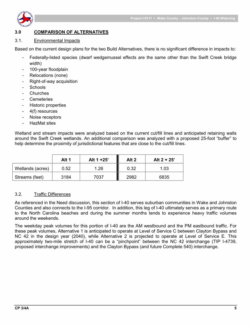
Wetland and stream impacts were analyzed based on the current cut/fill lines and anticipated retaining walls around the Swift Creek wetlands. An additional comparison was analyzed with a proposed 25-foot “buffer” to help determine the proximity of jurisdictional features that are close to the cut/fill lines.
Alt 1 Alt 1 +25’ Alt 2 Alt 2 + 25’
Wetlands (acres) 0.52 1.26 0.32 1.03
Streams (feet) 3184 7037 2982 6835
3.2. Traffic Differences
As referenced in the Need discussion, this section of I-40 serves suburban communities in Wake and Johnston Counties and also connects to the I-95 corridor. In addition, this leg of I-40 ultimately serves as a primary route to the North Carolina beaches and during the summer months tends to experience heavy traffic volumes around the weekends.
The weekday peak volumes for this portion of I-40 are the AM westbound and the PM eastbound traffic. For these peak volumes, Alternative 1 is anticipated to operate at Level of Service C between Clayton Bypass and NC 42 in the design year (2040), while Alternative 2 is projected to operate at Level of Service E. This approximately two-mile stretch of I-40 can be a “pinchpoint” between the NC 42 interchange (TIP I-4739, proposed interchange improvements) and the Clayton Bypass (and future Complete 540) interchange.

Project I-5111 •••• Wake County – Johnston County •••• I-40 Widening
CP 3/4A 6
Project I-5111 •••• Wake County – Johnston County •••• I-40 Widening
4.0 AVOIDANCE AND MINIMIZATION EFFORTS
Minimization efforts are ongoing as the design is refined. Efforts to date include:
• The project was designed to fit within the existing corridor wherever possible.
• Each overpass was closely reviewed to determine whether replacement was necessary. Very little new
right-of-way is needed in order to construct the project.
• Typical sections were minimized in order to reduce the fill to the outside shoulder.
• Changes to ramps are focused on safety & traffic flow, with only spot improvements proposed.
• The I-440 ramp reconfiguration utilizes the previously-disturbed highway corridor with no significant
community or natural impacts anticipated.
• Section 7 consultation measures at Swift Creek
o Bridge span is much longer than existing to provide a larger hydraulic opening and to minimize
the effects on Swift Creek and its floodplain
o Bridge bents will not be located in Swift Creek
o Hazardous spill basin BMP’s are being analyzed at the Swift Creek bridge where feasible
o Impacts from the 3 overlapping projects (I-5111, I-4739 and Complete 540) are being
constructed as part of I-5111 to minimize the temporal disturbance impacts
• There has been a significant amount of coordination between the Complete 540, I-4739 and I-5111
project teams to ensure the three projects would be constructible.
• I-5111 provides the widening/replacement of the Swift Creek bridge to address the ultimate buildout for
all three projects.
• I-5111 provides full-depth paved shoulder for the bus-on-shoulder system (BOSS) transit service.
• Design of hydraulic crossings takes into account the urbanization of the area and provides larger
hydraulic openings.
• Design Standards in Sensitive Watersheds will be used within the Swift Creek portion of the project.
5.0 ADDITIONAL INFORMATION
Coordination is continuing on several fronts regarding the Swift Creek bridge. Three separate TIP projects (I-
5111, I-4739, Complete 540) converge in the southern-most two miles of I-5111 near Swift Creek. NCDOT is
anticipating constructing the Swift Creek bridge crossing to accommodate the necessary lanes for all of these
projects. Doing so would minimize the magnitude and duration of the construction impacts to the traveling
public and the resources in the vicinity of Swift Creek. The bridge width is currently configured for a maximum
of 5 striped lanes in each direction with an accommodation for one additional lane in each direction for any
future widening. Section 7 consultation with USFWS is ongoing for R-2828 and the Biological Assessment for
I-5111 underway as well. NCDOT is coordinating the environmental studies and design for all three projects
to the greatest degree possible.
6.0 CURRENT PROJECT SCHEDULE / NEXT STEPS
Based on previous information provided, here is the updated I-5111 schedule and next steps:
• USFWS Section 7 - ongoing coordination amongst all 3 projects (see Sections 4 and 5 above)
• Noise Study – Completed
• Air Quality Study – Draft completed
• Public Meeting – Late Summer 2017
• Categorical Exclusion – Fall 2017
Project I-5111 •••• Wake County – Johnston County •••• I-40 Widening
CP 3/4A 7
Project I-5111 •••• Wake County – Johnston County •••• I-40 Widening
ATTACHMENTS
ATTACHMENT A October 2016 Merger Team Update Memo
ATTACHMENT B Proposed Updated Study Area Limits
ATTACHMENT C I-5111 Alternative 1 and Alternative 2 Figures

ATTACHMENT A

Merger Team Update
for Concurrence Points 1 and 2
October 2016
STIP Project I-5111
Wake & Johnston Counties
I-40 Widening
From I-440 (Exit 301, I-40/Raleigh Beltline split) to NC 42 (Exit 312)
North Carolina Department of Transportation

Project I-5111 •••• Wake County – Johnston County •••• I-40 Widening
Merger Team Update 1
Project I-5111 •••• Wake County – Johnston County •••• I-40 Widening
STIP Project I-5111
Wake & Johnston Counties
I-40 Widening
From I-440 (Exit 301, I-40/Raleigh Beltline split) to NC 42 (Exit 312)
1.0 INTRODUCTION
The North Carolina Department of Transportation (NCDOT) proposes to widen I-40 from I-440 (Raleigh
Beltline) near Exit 301 where I-40 and I-440 diverge, to near Exit 312 at the interchange of I-40 and NC
Highway 42. The proposed project, I-5111, is included in the 2016-2025 North Carolina Transportation
Improvement Program (TIP) for planning and design. Funding for construction is currently posted in the TIP as
beginning in Fiscal Year 2018.
As a takeaway from the December 16, 2015 Merger Update meeting, the Project Team is providing a revised
Purpose and Need Statement and Study Area. Additional clarification of alternatives was also requested,
particularly the number of lanes added under each Alternative. The handout and final minutes from the
December meeting are included in Appendix A.
2.0 PURPOSE REVISIONS
As noted during the December 16, 2015 Merger Update meeting, the purpose and need statement needs to be
revised because of the updated design year from 2035 to 2040. In addition, the LOS D threshold is not
expected to be met based on the updated traffic forecast received in June 2015.
Original Purpose
The Project Purpose is to improve the Level of Service on I-40 within the limits of the project study area,
providing a Level of Service (LOS) “D” or better, on all sections of I-40 from Exit 301 (Beltline in Raleigh) to Exit
312 (NC 42) in Johnston County, through the year 2035 (Design year).
New Purpose
The purpose of the proposed project is to better accommodate forecasted levels of congestion on I-40 from
Exit 301 (Beltline in Raleigh) to Exit 312 (NC 42) through the year 2040 (Design year), in accordance with the
MPO’s (CAMPO) long term goals to impart a positive impact on mobility for the public using this transportation
corridor.
Need for Project
Current traffic conditions on I-40 throughout the proposed project limits are often very crowded and subject to
frequent delays, due to regional commuting patterns, particularly during morning and evening rush hours. With
Raleigh and Research Triangle Park serving as employment centers for the region, many people commute into
the Raleigh area and live in outlying towns and surrounding counties. This section of I-40 serves suburban
communities in Wake and Johnston Counties and also connects to the I-95 corridor. In addition, this leg of I-40
ultimately serves as a primary route to the North Carolina beaches and during the summer months tends to
experience heavy traffic volumes around the weekends.
Information provided by NCDOT’s Traffic Forecasting Unit and Congestion Management Unit shows recent
data (year 2015 No-Build) for traffic conditions throughout the limits of the proposed project generally operating
at LOS “D” and “E”. The 2040 No-Build scenario would deteriorate into a LOS “F” condition. Public comments

Project I-5111 •••• Wake County – Johnston County •••• I-40 Widening
Merger Team Update 2
Project I-5111 •••• Wake County – Johnston County •••• I-40 Widening
from the Citizens Information Workshop support this information, conveying for many attendees the frustration
with the congestion and delays experienced on a daily basis when traveling along this segment of I-40.
Travelers on I-40 in the project area regularly experience congestion, which is projected to worsen through
2040. Traffic volumes along I-40 in the project area are projected to increase by 50 to 61 percent between
2015 and 2040. Existing and estimated average travel speeds are well below the posted speed limit during
peak hours.
Improving 2040 Build travel conditions on I-40 throughout this portion of the freeway, with a goal of achieving
LOS “E” or better, will help achieve CAMPO’s desired long-term goals, including alleviating one of their
identified bottlenecks on I-40 (bottleneck #9 in CAMPO’s 2013 Status of the System Report). This will have a
direct and positive impact on mobility experienced by the public using this corridor and allow for more efficient
long range travel and daily commuting between Raleigh and NC 42 with fewer delays.
3.0 STUDY AREA
Due to the modifications to the design along portions of I-40, the Study Area needs to be widened slightly,
particularly around the I-440 interchange and US 70 Business interchange. The I-440 interchange was
expanded to accommodate the new flyover ramps. The US 70 Business interchange may include a new
“leftover” from eastbound US 70 to westbound I-40, in order to eliminate the loop in the southeast quadrant
and subsequent problematic weave section onto I-40 westbound. See Appendix B for a revised Study Area
map.
4.0 TWO BUILD ALTERNATIVES ARE BEING CARRIED FORWARD FOR DETAILED STUDY
NCDOT TIP Project I-5111 involves widening and capacity improvements to existing I-40 from the I-440
interchange in Wake County to south of NC 42 in Johnston County. Generally along existing I-40 there are
currently three lanes in each direction between I-440 and US 70 Business, and two lanes in each direction
between US 70 Business and NC 42. The general scope of this project involves widening to accommodate
two additional travel lanes in each direction. As part of the preliminary design, two alternatives are under
consideration by the Department, in addition to the No Build.
4.1. Build Alternative 1
Widening to accommodate the addition of 2 general purpose lanes in each direction throughout the project
limits.
4.2. Build Alternative 2
Widening to accommodate the addition of 2 general purpose lanes in each direction, but with only 1 general
purpose lane in each direction from south of US 70 Clayton Bypass to NC 42.
Included in Appendix C are two figures (Alternative 1 and Alternative 2) that display what the existing laneage
is along I-40, and what additional lanes are being proposed.

Project I-5111 •••• Wake County – Johnston County •••• I-40 Widening
Merger Team Update 3
Project I-5111 •••• Wake County – Johnston County •••• I-40 Widening
5.0 ADDITIONAL INFORMATION
At both the February 2011 Concurrence Point 1/2 Meeting and the December 16, 2015 Update Meeting, the
Merger Team agreed there was no need to conduct a Concurrence Point 2A meeting. The next planned
meeting is the Concurrence Point 3 (LEDPA) Meeting.
Coordination is continuing on several fronts regarding the Swift Creek bridge. Three separate TIP projects (I-
5111, I-4739, R-2828) converge in the southern-most two miles of I-5111 near Swift Creek. NCDOT is
anticipating constructing the Swift Creek bridge crossing to accommodate the necessary lanes for all of these
projects. Doing so would minimize the magnitude and duration of the construction impacts to the traveling
public and the resources in the vicinity of Swift Creek. The exact number of lanes (bridge width) and bridge
length are currently under study and will be determined in the near future. Section 7 consultation with USFWS
is ongoing for R-2828 and the Biological Assessment for I-5111 will be underway in late 2016/early 2017.
NCDOT is coordinating the environmental studies and design for all three projects to the greatest degree
possible.
6.0 CURRENT PROJECT SCHEDULE / NEXT STEPS
Based on previous information provided, here is the updated I-5111 schedule and next steps:
• USFWS Section 7 - ongoing coordination amongst all 3 projects (see Section 5.0 above)
• Noise Study – Anticipated Fall 2016 completion
• Air Quality Study – Anticipated Fall 2016 completion
• Indirect & Cumulative Effects – Updated Fall 2015
• Draft Environmental Assessment – December 2016
• Final EA – Spring 2017
• FONSI – December 2017

ATTACHMENT B

PATH: \\CLTSMAIN\GIS_DATA\GIS\PROJECTS\000166_NORTHCAROLINADEPTOFTRANSPORTATION\0219635_NCDOTI-5111TASKORDER#1\MAP_DOCS\MXD\WORKING\I-5111 STUDY AREA 2015.MXD - USER: JJAMISON - DATE: 2/5/2016
ADDITIONAL STUDY AREA
ATTACHMENT BNCDOT STIP I-5111
0 1.25MilesO
DATA SOURCE: World Street Map
LEGEND
Additional Study AreaOriginal Study Area

ATTACHMENT C

I-5111: Alternative 1
US 70 Business
US 70 Bypass
I-40
I-40
NC 42
Legend
Existing Lanes
Proposed Lanes
Interchange
BeginProject
EndProject
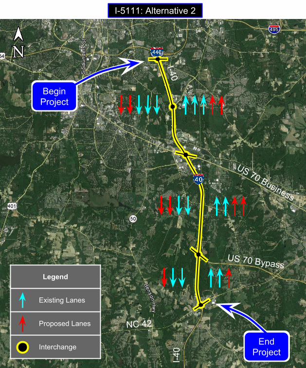
I-5111: Alternative 2
US 70 Business
US 70 Bypass
I-40
I-40
NC 42
Legend
Existing Lanes
Proposed Lanes
Interchange
BeginProject
EndProject