memorandum - wa
TRANSCRIPT

5309 Shilshole Avenue NW
Suite 200
Seattle, WA 98107
206.789.9658 phone
206.789.9684 fax
www.esassoc.com
memorandum
date May 22, 2017 to Glen Pickus, City of Snohomish from Mark Johnson and Malia Bassett, ESA subject City of Snohomish, Shoreline Master Program Update – Cumulative Impacts Analysis and No Net Loss Memorandum With the assistance of a grant from the State Department of Ecology, the City of Snohomish is updating its Shoreline Master Program (SMP) consistent with state guidelines (WAC Chapter 173-26). Under the shoreline guidelines, local jurisdictions are required to evaluate and consider cumulative impacts of reasonably foreseeable future development in the shorelines of the state (WAC 173-26-186(8)(d)). This memorandum assesses the potential cumulative impacts that would result from development and activities in the shoreline within the city over time under the provisions contained in the Draft SMP (Planning Department Recommended Draft, dated May 2017). This memorandum will be revised as necessary at the time of local adoption to reflect any City Council changes within the locally adopted SMP.
The City of Snohomish is located on the north side of the lower Snohomish River valley, approximately 11 miles upstream from where the river enters Puget Sound at Everett. The city is bordered by the Snohomish River to the south and the Pilchuck River to the east. The Pilchuck River enters the Snohomish River 0.5 miles south of the city limits. The city encompasses an area of approximately 3.25 square miles and as of 2011 the city’s population was approximately 9,200. Incorporated in 1890, the city has a long physical presence and history. Today, it is an important residential and cultural center of the county with a diverse economic base. There are approximately 4.57 miles of shoreline representing designated shorelines of the state (shorelines) in the City’s planning area (city limits). The City’s shoreline planning area has been organized into eight distinct segments or “reaches” based broadly on the physical characteristics along the shoreline, the level of ecological functions provided by each segment, as well as existing land uses and zoning.
The purpose of evaluating cumulative impacts is to ensure that, when implemented over time, the proposed SMP goals, policies and regulations will achieve no net loss of shoreline ecological functions from current “baseline” conditions. Baseline conditions are identified and described in the City of Snohomish Draft Shoreline Inventory and Characterization Report (ESA 2010, updated May 2017). The draft Snohomish SMP provides standards and procedures to evaluate individual uses or developments for their potential to impact shoreline resources on a case-by-case basis through the permitting process. The purpose of this memorandum is to determine if impacts to shoreline ecological functions are likely to result from the aggregate of activities and developments in the shoreline that take place over time.
Appendix C

May 2017 City of Snohomish Shoreline Master Program Update – Cumulative Impacts Analysis and No Net Loss Memorandum
The guidelines state that, “to ensure no net loss of ecological functions and protection of other shoreline functions and/or uses, master programs shall contain policies, programs, and regulations that address adverse cumulative impacts and fairly allocate the burden of addressing cumulative impacts among development opportunities. Evaluation of such cumulative impacts should consider:
Current circumstances affecting the shorelines and relevant natural processes;
Reasonably foreseeable future development and use of the shoreline; and
Beneficial effects of any established regulatory programs under other local, state, and federal laws.1
This cumulative impacts assessment uses these three considerations as a framework for evaluating the potential long-term impacts on shoreline ecological functions and processes that may result from development or activities under the proposed SMP over time. In addition, Appendix A evaluates provisions of the draft SMP in the context of shoreline ecological functions and ecosystem-wide processes as defined by the guidelines.
Current Circumstances As part of the City’s SMP update process, a Shoreline Inventory and Characterization Report, including a map folio, were prepared and submitted for technical agency review in June 2010. This Report (ESA, updates of 2010 version completed in May 2017) identifies existing conditions and evaluates the ecological functions and processes in the City’s shoreline jurisdiction. The inventory included all shoreline areas within the City of Snohomish and its designated UGA. Baseline conditions are summarized very briefly below. For additional review and detail please refer to the Inventory and Characterization Report.
Physical and Ecological Processes The City’s shoreline jurisdiction is defined by the surface geology and hydrology of the valley floor of the Snohomish River Basin including its major tributaries (Pilchuck, Skykomish, and Snoqualmie Rivers) and contributing streams. The headwaters of both the Snohomish and Pilchuck Rivers are predominantly located within the Cascade Mountains and foothills, Mount Baker-Snoqualmie National Forest, and private commercial timberlands. The landscape of the jurisdiction has been heavily influenced by frequent flooding events which have historically covered the valley with layers of mud, silt, ash, and glacial debris. The broad floodplains of both river systems have created a vast mosaic of fluvial materials and silts eroded from headwater sources.
The Snohomish River Basin covers an area of approximately 1,856 square miles across both King and Snohomish Counties and contains about 2,718 miles in stream length, making it the second largest basin draining into Puget Sound. The Skykomish and Snoqualmie Rivers originate in the Cascade Mountains and join near the City of Monroe where they become the Snohomish River. The Snohomish River flows into the estuary downstream from the City of Snohomish and empties into Puget Sound between Everett and Marysville.
The Snohomish River Basin was one of the earliest areas settled in the Puget Sound region. Historically, the study area was characterized by large tracts of old-growth forests, fertile river valley soils, and abundant runs of salmon.
1 WAC 173-26-286(8)(d)
2

May 2017 City of Snohomish Shoreline Master Program Update – Cumulative Impacts Analysis and No Net Loss Memorandum
Urbanization and development within the upper watershed of the Snohomish River Basin have been limited compared to lower watershed where urbanization has occurred in the Puget Sound lowlands. The upper watershed of the Snohomish River has been affected by timber harvest and road building practices that have reduced the ability of riparian areas to provide wood and shade to the river and stream channels. These areas also continue to contribute to fine sediments from road construction and landslides in each river system. The lower watershed has experienced historical clearing of forests, construction of impervious surfaces, and stabilization of the riparian corridor that combine to alter the quality and movement of water through the watershed.
Habitat and Species The shorelines within Snohomish provide important habitat for a number of fish and wildlife species. The aquatic environment of both rivers is an important riverine corridor from the Cascade Mountains to Puget Sound. Most notably, the Snohomish and Pilchuck Rivers have been designated as critical habitat for Chinook salmon, steelhead, and bull trout. All three species are listed as threatened under the Federal Endangered Species Act. Therefore, fish passage, especially for federally listed species, is an important function of the shorelines within the City of Snohomish. Priority fish species have not been identified within the Blackmans Lake shoreline planning area.
Modifications to the river system and Blackmans Lake shoreline have resulted in reduced levels of ecosystem functioning, including hydrology, water quality, riparian habitat, sediment transport, and in-stream as well as lacustrine habitat. Changes to hydrology focus on modified flow regime due to dam construction, intake diversion, and urban development. River management and shoreline stabilization have reduced the connection between the rivers and Blackmans Lake with their respective floodplains, changing the spatial extent of habitats, and increasing the potential for negative water quality impacts. Disturbances to the channel banks and lake shorelines have resulted in areas that are dominated by non-native invasive species. Wood, in the form of riparian trees and in-channel wood, is generally lacking throughout the system, which negatively impacts riparian and aquatic habitats. In general, the level of modification increases moving downstream and toward the city center in both river systems; higher occurrence of riverine disturbances consequently result.
Important features of the City of Snohomish’s shoreline environment that provide habitat include:
Streams (fish and wildlife corridors and sources of fluvial sediments);
Riparian zones (vegetated bars and vegetation overhanging the stream reach);
Lakes;
Wetlands; and
Aquifer recharge areas.
Examples of aquatic and terrestrial species found in or near the City of Snohomish that utilize crucial shoreline habitat include:
Salmonids (including listed species such as Chinook, steelhead, and bull trout);
Resident cutthroat,
3

May 2017 City of Snohomish Shoreline Master Program Update – Cumulative Impacts Analysis and No Net Loss Memorandum
Waterfowl, bald eagle, bats, great blue heron, and pileated woodpecker;
Salamanders, frogs, amphibians; and
Mammals: raccoons, beavers, deer.
Land Use and Public Access According to Snohomish County Assessor records (2009), current land use in Snohomish’s shoreline planning area is a mix of mainly residential, parks and open spaces with some commercial uses. One notable exception is the City’s Wastewater Treatment Plant at the city’s western edge which, including associated wetlands, comprises 35 percent of the entire shoreline planning area.
Table 1. Land Use Designations in Shoreline Planning Area
Waterbody Industrial Residential Park and Open Space Commercial Mixed Use Urban
Horticulture Historic Business Grand Total
Blackmans Lake 0.00% 76.64% 23.36% 0.00% 0.00% 0.00% 0.00% 100.00%
Pilchuck River 0.00% 19.41% 44.14% 5.02% 29.65% 1.79% 0.00% 100.00%
Snohomish River 60.86% 2.80% 16.59% 9.52% 0.00% 7.48% 2.75% 100.00%
Total 34.54% 25.20% 22.98% 6.24% 4.94% 4.54% 1.56% 100.00%
Residential areas constitute the second most common land use (25 percent of entire shoreline planning area) located along the northern half of the Pilchuck River shoreline and the southern half of Blackmans Lake (77% of Blackmans Lake planning area). Parks and Open Space comprise nearly a quarter of the shoreline planning area and are focused mostly near the confluence of the Pilchuck and Snohomish Rivers. Additional pockets of open space can be found on the shores on the Pilchuck within the city limits. Farmland located at the south end of Lincoln Avenue is zoned for urban horticulture, and is used for recreational events as well as agricultural purposes.
Commercial uses, including the historic business district, are slightly less common and are mainly concentrated along the north shore of the Snohomish River in the city center (13 percent of the Snohomish River planning area). Mixed use areas are located completely within the Pilchuck River planning area and account for 5 percent of total land uses within the city-wide planning area.
The demand for water-dependent uses has decreased with the change in the economic basis of the community. Where the Snohomish once depended on the Snohomish River as a source of transportation and commerce, the city and the river have now become a destination for recreation and tourism. Strengthening and further developing the downtown area’s orientation to the Snohomish River is a key goal for the near future, as well as promoting both rivers and Blackmans Lake for tourism and increased public access. The City’s water treatment plant on the Pilchuck River is expected to continue and is a water-dependent facility.
4

May 2017 City of Snohomish Shoreline Master Program Update – Cumulative Impacts Analysis and No Net Loss Memorandum
Shoreline Alterations
Snohomish River
The construction of levees, rip rap and armoring on both the north and south shores of the Snohomish River have altered the river's flow patterns disconnecting the river from its floodplain and some associated wetlands. Because the extensive diking and channelization severely limit overbank flows, finer materials such as sand, silt, and clay tend to be deposited in the flatter, slower moving portions of the lower river channel rather than being distributed across the nearby floodplain affecting soils, vegetation, and floodplain habitat. Decades of industrial and commercial uses have increased the amount of impervious surfaces along the shoreline and beyond. As a result surface runoff, stormwater pollution, and sediment input to the river have increased while infiltration has decreased.
Historical and intense in-stream gravel mining between 1962 and 1991 may have caused incision of the riverbed and a change in channel elevation; however, the degree to which the shorelines of the Snohomish River were affected by mining is not fully known. Mining is no longer occurring within city limits.
There are three over-water structures within the Snohomish River shoreline planning area: the SR 9 and Avenue D bridges, and the railroad trestle. The new boat launch at 20 Lincoln Ave., the old boat launch at Cady Park and the unnamed beach access at the east end of the city are the only water access points along this stretch of the river. There are no functioning piers or docks in the Snohomish River shoreline planning area.
Pilchuck River
The Pilchuck River’s floodplain is constrained by steep bluffs on the western bank and levees along the eastern bank. The levees disconnect the river from portions of its floodplain and contribute to channelization. Because the river is cut off from its floodplain, sediments become deposited within the channel. Rip rap and other types of shoreline armoring are evident in places, especially beneath the bridges. The floodplain widens near the confluence with the Snohomish River.
The City water treatment plant is located approximately 16 miles northeast from the city center at RM 26.4. A dam diverts river water to the treatment plant which produces approximately one million gallons of potable water a day at full operation. There are numerous other private water withdrawals on the river for agriculture, irrigation, and other uses located outside city limits. During summer months, it is estimated that withdrawals by the City of Snohomish can remove 5 to 20 percent of the summer low flows from the river. During periods of high precipitation, the river receives high flows from Swifty Creek, the outlet stream from Blackmans Lake.
Gravel mining between 1969 and 1991 removed gravel from the river channel, gravel bars, and floodplain may have altered channel profile. Gravel mining and bank erosion have contributed to excess sediment in the river. In-stream mining has not occurred for several decades. Gravel mining continues within the floodplain on the east side of the river in unincorporated Snohomish County.
Blackmans Lake
Approximately half of the watershed feeding Blackmans Lake has been urbanized, with associated increases in impervious surfaces and stormwater runoff entering the lake. In response, the hydrology of Blackmans Lake has
5

May 2017 City of Snohomish Shoreline Master Program Update – Cumulative Impacts Analysis and No Net Loss Memorandum
been significantly altered to maintain desired water levels in the lake. The lake historically discharged to Swifty Creek, which runs south through the city into the Snohomish River (near Cady Park). Low flows below 1 to 2 cubic feet per second still discharge to Swifty Creek at the lake outlet; however, in the 1980s a flow splitter was installed to direct high flows into a pipe system. This pipe system was provided to alleviate elevated surface water levels that were occurring during storm events. The pipe system extends along 6th Street to the east of Blackmans Lake, with bypassed high flows discharged into the Pilchuck River.
An outlet improvement project completed in 2016 removed accumulated sediment and encroaching invasive vegetation along 370 lineal feet of the existing outlet channel, constructed an additional 580 lineal feet of new channel, and replaced 150 lineal feet of 24-inch culvert. The project included habitat restoration along the outlet channel, including native tree and shrub plantings. By stabilizing the water level of the lake the shoreline ecology should benefit.
In addition to basin alterations impacting Blackman Lake hydrology and outlet conditions, past removal of emergent vegetation from lake may also have contributed to erosion of shoreline beach on south side of lake.
Restoration Opportunities In addition to the inventory and characterization report, a draft Shoreline Restoration Plan has been developed as part of the SMP update (ESA 2011). The draft plan identifies potential projects that could benefit shoreline ecological functions. However, because these restoration projects are not currently funded, they are not considered in this analysis.
Reasonably Foreseeable Future Development and Use
Snohomish River Plans for development of the downtown riverfront area include improvements to the Riverfront Trail. Properties west of Avenue D are not likely to redevelop in near future, but could be developed for mixed use development. For those City owned properties at the west end (wastewater treatment plant and City shop yard), the City has conducted numerous studies to redevelop this area with new parks and trails. Implementation and development of any new parks and trails is contingent upon funding.
Potential exists for more formalized and enhanced public access in the urban horticultural area by the base of Lincoln Avenue. For the remaining privately owned commercial properties abutting the river, mixed-use redevelopment may occur but would occur within established standards set by the City including provisions for buffers. Mining would be prohibited in this and all other shorelines in the city.
Pilchuck River Parks and open space exist at the north (Morgantown Park) and south (Pilchuck Park and Recreational Fields) ends of the urban conservancy designation and little redevelopment potential exists within these areas. The western bank of the river between these two points consists mostly of steep banks with upland development outside of the steep slope and required buffer. While there is little room for infill development, redevelopment of some existing uses in the shoreline planning area is likely in the long-term. Provisions may allow some non-water
6

May 2017 City of Snohomish Shoreline Master Program Update – Cumulative Impacts Analysis and No Net Loss Memorandum
dependent uses as long as they are outside the buffer. At the City’s water intake facility property, potential projects to reduce the effects of the dam including removal have been studied. While final plans and funding have not been identified, the City Council has passed a resolution to conditionally close the water treatment plant and to remove the water supply diversion dam if certain outcomes are achieved, including the preservation of the City’s water rights. Mining would be prohibited in this and all shorelines.
Blackmans Lake Most of area available for residential development has already been developed with only one parcel having potential for future subdivision. Wetlands on the south shore and north shore also restrict future redevelopment due to critical area provisions and protections.
Limited over-water development water may occur. Of the 28 existing lots on the lake, 23 contain small docks; therefore, there is limited potential for new docks in the future.
Beneficial Effects of Any Established Regulatory Programs under Other Local, State, and Federal Laws A variety of other regulatory programs, plans, and policies work in concert with the City’s SMP to manage shoreline resources and regulate development near the shoreline (see Chapter 1 of the Inventory and Characterization Report).
Snohomish Municipal Code and Long Range Plans
Snohomish Comprehensive Plan
The City’s Comprehensive Plan establishes the general land use pattern and vision of growth and development the City has adopted for areas both inside and outside the shoreline jurisdiction. The Environmental Protection Element of the Comprehensive Plan currently contains goals and policies specifically for shoreline management and is intended to maintain consistency with the Shoreline Master Program goals and policies. With the updated SMP the intent is to place shoreline goals and policies in a separate Shoreline Element.
Title 14 Land Use Development Code (Snohomish Municipal Code)
SMC Chapter 14.90 State Environmental Policy Act (SEPA): Every project requiring a shoreline permit must also demonstrate compliance with the State Environmental Policy Act (SEPA). For non-exempt proposals, the SEPA process assures that significant adverse environmental impacts are identified, minimized and mitigated, where possible. The City’s SEPA procedures and policies are outlined in Chapter 14.90 of the SMC, including adoption of the state’s SEPA rules by reference (Chapter 197-11 WAC).
SMC Chapters 14.255, 14.260, 14-270, 14.275, and 14.280 Critical Areas: City of Snohomish critical areas regulations restrict development in and near wetlands, aquifer recharge areas, flood hazard areas, geologic hazard areas, and habitat conservation areas. All shorelines in the city are classified as habitat conservation areas, and some areas are also classified as other types of critical areas as well. In habitat conservation areas, most uses must maintain an undeveloped, vegetated buffer of 100 feet. Under limited circumstances, some uses may encroach within 50 feet of the water’s edge, provided mitigation is included to protect against loss of ecological functions
7

May 2017 City of Snohomish Shoreline Master Program Update – Cumulative Impacts Analysis and No Net Loss Memorandum
of the buffer and habitat area. Development within wetlands and within the floodway is also prohibited. Development may be permitted in other flood hazard areas and geologically hazard areas provided the project design considers these hazards. The critical area regulations have the effect of protecting most of the remaining riparian vegetation and in-water habitat in the shorelines, while generally allowing existing development to remain.
SMC Chapters 14.240 Landscaping, Screening, Fencing, and Retaining Walls: As related to environmental protections, the purpose of the regulations are to: “preserve any existing natural wooded character; reduce erosion; promote utilization of natural systems; provide permeable surface areas to recharge subsurface aquifer and reduce quantity of stormwater runoff; maintain or replace existing vegetation; moderate the microclimate; protect and enhance watercourses, riparian habitat, and associated wildlife; and reduce impacts of development on the storm drain system” (14.240.010).
Title 15 Sewer, Water, and Stormwater (Snohomish Municipal Code)
SMC Chapter 15.16 Stormwater Management: The intent of the City’s stormwater management, as stated in Chapter 15.16 of the SMC, is to “promote the public health, safety, and welfare by providing for the comprehensive management of surface and storm waters, erosion control, and flooding.” (SMC 15.16.010). The City adopted the 2012 Department of Ecology Stormwater Management Manual for Western Washington together with amendments or corrections. Stormwater management regulations have been established “to minimize water quality degradation; to prevent flood damage, siltation, and habitat destruction in the City’s creeks, streams, and other water bodies; to protect property owners adjacent to developing land from increased runoff rates which could cause stream erosion and damage to public and private property; to promote sound development and redevelopment policies which respect and preserve the City’s watercourses and aquatic habitat; to promote low impact development practices; to reduce impervious surface and stormwater runoff; to ensure the safety of City streets and rights-of-way; and to prevent water quality degradation and promote ground water recharge through the implementation of comprehensive and thorough permit review, construction inspection, enforcement, and maintenance programs” (15.16.010). The manual also “encourages low impact development (LID) best management practices (BMPs), as an alternative to conventional stormwater management systems that rely on detention ponds and closed conveyance” (SMC 15.16.060). Low impact development is intended to manage runoff close to the source of generation and to mimic the predeveloped hydrologic condition of a site.
State and Federal Regulations A number of state and federal agencies may have jurisdiction over land or natural elements in the City’s shoreline jurisdiction. Local development proposals most commonly trigger requirements for state or federal permits when they include work in or over waters of the state; impact wetlands or streams; potentially affect fish and wildlife listed under the federal Endangered Species Act (ESA); result in over one acre of clearing and grading; or affect the floodplain or floodway. As with local requirements, state and federal regulations may apply throughout the city, but regulated resources are common within the City’s shoreline jurisdiction. The state and federal regulations affecting shoreline-related resources include, but are not limited to:
Endangered Species Act: The federal ESA addresses the protection and recovery of federally listed species. The ESA is jointly administered by the National Oceanic and Atmospheric Administration (NOAA) Fisheries
8
May 2017 City of Snohomish Shoreline Master Program Update – Cumulative Impacts Analysis and No Net Loss Memorandum
(formerly referred to as the National Marine Fisheries Service), and the United States Fish and Wildlife Service (USFWS).
Clean Water Act (CWA): The federal CWA requires states to set standards for the protection of water quality for various parameters, and it regulates excavation and dredging in waters of the U.S., including wetlands. Certain activities affecting wetlands in the City’s shoreline jurisdiction or work in the adjacent rivers may require a permit from the U.S. Army Corps of Engineers and/or Washington State Department of Ecology under Section 404 and Section 401 of the CWA, respectively.
Federal Emergency Management Agency (FEMA) National Flood Insurance Program: Communities that participate in the National Flood Insurance Program receive federally backed flood insurance. In order to participate, the community must adopt and enforce floodplain management ordinances, which reduce future flood damage. The National Flood Insurance Program is also responsible for mapping the country’s flood hazard areas.
National Pollutant Discharge Elimination System (NPDES): Ecology regulates activities that result in wastewater discharges to surface water from industrial facilities or municipal wastewater treatment plants. NPDES permits are also required for stormwater discharges from industrial facilities, construction sites of one or more acres, and municipal stormwater systems that serve census-defined Urbanized Areas, which include any urbanized areas with more than 50,000 people and densities greater than 1,000 people per square mile.
Hydraulic Project Approval (HPA): The Washington Department of Fish and Wildlife (WDFW) regulates activities that use, divert, obstruct, or change the natural flow of the beds or banks of waters of the state and which may affect fish habitat. Projects in the shoreline jurisdiction requiring construction below the ordinary high water mark of rivers or lakes could require an HPA from WDFW. Projects creating new impervious surface that could substantially increase stormwater runoff to waters of the state may also require approval.
Conclusion The cumulative actions taken over time in accordance with the City of Snohomish’s proposed SMP are not likely to result in a net loss of shoreline ecological functions from existing baseline conditions. This conclusion is based on an assessment of the three factors identified in the Ecology guidelines for evaluating cumulative impacts:
Current circumstances affecting the shorelines and relevant natural processes;
Reasonably foreseeable future development and use of the shoreline; and
Beneficial effects of any established regulatory programs under other local, state, and federal laws.
The regulatory provisions of the Draft SMP (May 2017) would serve to maintain or improve the overall condition of shoreline resources. The proposed SMP provides a new system of shoreline environment designations that establishes more uniform management of the City’s shoreline. The updated development standards and regulation of shoreline modifications provides more protection for shoreline processes. The updated standards and regulations are more restrictive of activities that would result in adverse impacts to the shoreline environment. The restoration plan, when implemented, would provide the City with opportunities to improve or restore
9
May 2017 City of Snohomish Shoreline Master Program Update – Cumulative Impacts Analysis and No Net Loss Memorandum
ecological functions that have been impaired as a result of past development activities. In addition, the proposed SMP is meant to compliment several City, county, state and federal efforts to protect shoreline functions and values.
.
10

City of Snohomish, Shoreline Master Program Update May 2017 Cumulative Impacts Analysis
Appendix A Assessment of Shoreline Functions Along Snohomish Shorelines


Ecological Processes/Functions WAC 173-26-201(3)(d)(i)(C)
Current Performance (Shoreline Inventory and Characterization Report - ESA Adolfson, 2011)
Likely Development By Shoreline Environment Designation (SED)
SMP Provisions Protection or Restoration Protection = Proposed SMP regulations (with reference to SMP section number) Restoration = Draft Restoration Plan Policy
Future Performance By Shoreline Environment Designation (SED)
Snohomish River
Hydrology Flow regime, sediment transport, and floodplain interaction
The Snohomish River experiences two periods of peak flows each year: during the heavy rains of November – January, and during snowmelt in May and June. Flows are typically lowest in August when there is little rain and the snowpack in the Cascades has melted. Swifty Creek is the outlet stream from Blackmans Lake and discharges to the Snohomish River near Cady Park, with high flows diverted by piped conveyance to the Pilchuck River. The floodplain of the Snohomish River is mapped as an aquifer recharge area. The construction of levees, rip rap and armoring on both the north and south shores of the Snohomish River have altered the river's flow patterns disconnecting the river from its floodplain and some associated wetlands. Because the extensive diking and channelization severely limit overbank flows, finer materials such as sand, silt, and clay tend to be deposited in the flatter, slower moving portions of the lower river channel rather than being distributed across the nearby floodplain affecting soils, vegetation, and floodplain habitat. Decades of industrial and commercial uses have increased the amount of impervious surfaces along the shoreline. As a result surface runoff, stormwater pollution, and sediment input to the river have increased while infiltration has decreased. Historical and intense in-stream gravel mining between 1962 and 1991 may have caused incision of the riverbed and a change in channel elevation; however, the degree to which the shorelines of the Snohomish River were affected by mining is not fully known. Mining no longer occurs within the City’s shorelines.
AQUATIC Limited development over or in the water may occur. Small overwater structures such as small marinas or private docks are allowed but few are anticipated because most of the shoreline is City-owned, and dock development on the river is complicated by flooding and other environmental constraints. Over the long term, larger infrastructure projects such as bridge work and utility facilities may be constructed; however, no plans for in- or over-water utility development exist. The City does, however, propose to bore under the Snohomish River at the Wastewater Treatment Plan for a sanitary sewer force main. Relocation of the City’s boat ramp would require shoreline stabilization and placing a paved ramp in the river. HISTORIC RIVERFRONT The City owns almost all waterfront properties within designation east of Ave D. Plans for development of this area include improvements to the Riverfront Trail. Any trail improvements and subsequent increase in pedestrian traffic would be offset by mitigation (e.g additional overhanging vegetation). Properties west of Ave D are not likely to redevelop in near future, but could be developed for mixed use development. URBAN CONSERVANCY For those City owned properties north of the Snohomish River and west of Ave D (wastewater treatment plant and City shop yard), the City has conducted numerous studies to redevelop this area with new parks and trails. Implementation and development of any new parks and trails is contingent upon funding. For the remaining privately owned commercial
PROTECTION General
• Land clearing, grading, filling and alteration of natural drainage features and landforms shall be limited to the minimum necessary for development. To the extent practical, native vegetation shall be preserved and native topsoils shall be preserved and re-used on-site. Areas cleared of vegetation but not developed shall be replanted. (14.250.100.C.8)
• Except within the Historic Riverfront Environment all shoreline uses and development shall be located, designed, constructed, and managed to minimize interference with or adverse impacts to beneficial natural shoreline processes such as water circulation, erosion and accretion (14.250.100.C.9)
• All shoreline uses and development shall be located and designed to minimize reliance upon shoreline defense and stabilization measures and flood protection works such as bulkheads, other bank stabilization, landfills, levees, dikes, groins, jetties or substantial site re-grading (14.250.100.C.10).
• All development in the 100-year floodplain designated on the current flood insurance rate map issued by FEMA shall include an assessment of potential effects the project would have on channel migration prepared by a qualified professional, and incorporate measures to mitigate any significant adverse impacts on channel migration (14.250.100.C.11).
Industrial • Logs: Except where no practical alternative exists, log storage shall occur on land; Free-fall dropping of logs into water is prohibited; Logs shall not be dumped, stored, or floated
in areas where grounding will occur (14.250.160.C.1, 3, 5). Residential Development
• Below-grade swimming pools shall be sited and designed so that they do not adversely affect the flow of groundwater or endanger unstable slopes (14.250.170.B.1.). Transportation
• Highway, street and railroad infrastructure that must be located in or over water, such as bridges and bridge supports, may be permitted provided that the substantive requirements of Chapter 14.255 SMC are satisfied, and the priorities of the City of Snohomish Shoreline Restoration Plan are addressed in designing mitigation for project impacts (14.250.200.C).
• Bridge abutments of earthen fill shall not be located within an Area of Special Flood Hazard as delineated on Flood Insurance Rate Maps issued by FEMA (14.250.200.E). • Transportation uses and facilities shall be designed to avoid or minimize placement of fill or structures that would restrict floodplain capacity or limit channel migration. Where
transportation facilities are proposed within floodplains or channel migration zones; the proposal shall conform to the requirements of Chapters 14.255 and 14.270 SMC and this chapter (14.250.200.F).
• Except within the Historic Riverfront Environment, roads and off-street parking facilities shall be located so as not to require shoreline stabilization (14.250.120.K.8). In-Water Uses
• New dams and hydroelectric facilities are prohibited in all environments (14.250.120.P16) In-water fish and wildlife management, except aquaculture, is a Permitted Use (14.250.120).
Boating Facilities • Marinas and boat launches shall not alter river currents such that adverse impacts would occur downstream. Boat launches and marinas shall be designed to meet criteria by
the State Department of Fish and Wildlife relative to disruption of currents, restriction of tidal prisms, flushing characteristics, and fish passage (14.250.190.C). Breakwaters, Jetties, Groins, and Weirs
• Breakwaters, jetties, groins and weirs shall only be permitted as a Conditional Use where necessary to support water dependent uses, public access, approved shoreline stabilization, or other public uses, as determined by the City Planner. Groins shall only be permitted as part of a restoration project sponsored or co-sponsored by a public agency (14.250.270.3).
Filling, Grading, and Dredging • Fill below the ordinary high water mark may be allowed as a conditional use only when meeting these criteria: When necessary to support a water dependent use; To provide
for public access; When necessary to mitigate conditions that endanger public safety, including flood risk reduction projects; To allow for cleanup and disposal of contaminated sediments as part of an interagency environmental cleanup plan; To allow for the disposal of dredged material considered suitable under, and conducted in accordance with, the dredged material management program of the Washington Department of Natural Resources; For expansion or alteration of transportation or utility facilities currently located on the shoreline upon demonstration that alternatives to fill are not feasible; or As part of mitigation actions, environmental restoration projects and habitat enhancement projects (14.250.300.C.1-7).
• Stockpiling of dredged material in or under water is prohibited (14.250.300.I) • The removal of gravel for flood management is allowed only after a biological and geomorphological study shows that extraction has a long-term benefit to flood hazard
reduction, does not result in a net loss of ecological functions, and is part of a comprehensive flood management solution (14.300.K). • Dredging and disposal of dredged material below the ordinary high water mark shall be permitted only: When necessary for the operation of a water dependent use; When
necessary to mitigate conditions that endanger public safety or fisheries resources; Dredging and disposal of dredged material below the ordinary high water mark shall be permitted for establishing, maintaining, expanding, relocating or reconfiguring navigation channels and basins when necessary to ensure safe and efficient accommodation of existing navigation uses when: Significant ecological impacts are minimized; The substantive requirements of Chapter 14.255 SMC are satisfied; and Dredging is maintained to the authorized location, depth and width; Dredging and disposal of dredged material below the ordinary high water mark shall be permitted for restoration projects associated with implementation of the Model Toxics Control Act or the Comprehensive Environmental Response, Compensation, and Liability Act; or any enhancement or restoration project; Dredging and disposal of dredged material below the ordinary high water mark shall be permitted for flood risk reduction projects conducted in accordance with Chapter 14.270 SMC (14.250.300.D.1-5).
• New development shall be sited and designed to avoid the need for new and maintenance dredging (14.250.300.P). Shoreline Stabilization
• Shoreline stabilization, including bulkheads and flood protection facilities, may be permitted where such measures are necessary to protect existing legally-established primary
AQUATIC No Change Since hydrological functions and processes are impaired by existing shoreline stabilization, changes to hydrology are unlikely. A new boat ramp would entail stabilization meeting standards that would protect hydrologic functions. No large scale over-water projects are planned for the future. HISTORIC RIVERFRONT No Change Since hydrological functions and processes are impaired by existing shoreline stabilization, changes to hydrology are unlikely. Some soft-shore stabilization may replace existing structural stabilization, particularly if the existing boat ramp Is removed. URBAN CONSERVANCY No Change Since hydrological functions and processes are impaired by existing shoreline stabilization, changes to hydrology are unlikely. Some soft-shore stabilization may replace existing structural stabilization
1

Ecological Processes/Functions WAC 173-26-201(3)(d)(i)(C)
Current Performance (Shoreline Inventory and Characterization Report - ESA Adolfson, 2011)
Likely Development By Shoreline Environment Designation (SED)
SMP Provisions Protection or Restoration Protection = Proposed SMP regulations (with reference to SMP section number) Restoration = Draft Restoration Plan Policy
Future Performance By Shoreline Environment Designation (SED)
Snohomish River
properties abutting the river, mixed-use redevelopment may occur which could bring in more human activity. However any redevelopment would occur within established standard set by the City including provisions for buffers. The Urban Conservancy area located by the base of Lincoln Ave is currently used for agriculture and recreation, providing periodic parking for soccer and other recreational uses. Potential exists for more formalized and enhanced public access, including a boat ramp, which would entail clearing, grading, paving, and increased vehicular activity at and near the water’s edge.
structures, public improvements, proposed or existing water-dependent development, and restoration/mitigation improvements (14.250.270. footnote 1) • An existing legally established shoreline stabilization structure may be replaced with a similar structure when it is demonstrated there is a need to protect principal uses or
structures from erosion caused by currents, tidal action, or waves (14.250.270 footnote 2). • Shoreline stabilization shall be designed and constructed to avoid adversely affecting ecological functions and downstream stability (14.250.280). • New shoreline stabilization shall not preclude river channel migration within the floodway (14.250.280.B). • New shoreline stabilization may occur when studies by qualified professionals demonstrate: That erosion from waves or currents has occurred and will continue to occur
without the proposal, and that damage is expected to occur if the shoreline stabilization is not constructed; That the proposal is the minimum necessary to protect existing legally-established structures, exiting water-dependent development, or projects for restoration of ecological functions; That, except for the protection of the shoreline requiring stabilization, the proposal will not preclude natural fluvial, hydrological, and geomorphological processes; That erosion is not caused by upland conditions on the project site that, if corrected, would eliminate the need for shoreline stabilization; That mitigation measures will maintain or augment shoreline processes and critical fish and wildlife habitat so that no net loss of function of riparian habitat will occur; That shoreline stabilization shall minimize the adverse impact to other properties to the maximum extent practical; That shoreline stabilization shall not be used to create new shoreland area; That shoreline stabilization shall not interfere with surface or subsurface drainage into the water body (14.250.280. E.1-8).
• Shoreline stabilization shall not interfere with surface or subsurface drainage into the water body (14.250.280.D.13). • Materials that may release hazardous substances shall not be used for shoreline stabilization (14.280.F). • Shoreline stabilization shall be designed so as not to constitute a hazard to navigation and shall not substantially interfere with visual access to the water (14.280.G). • Shoreline stabilization shall be designed so as not to create a need for shoreline stabilization elsewhere (14.250.280.H). • Shoreline stabilization measures shall not be allowed within any designated floodway except as may be necessary to protect existing development or prevent serious
impairment of channel function (14.250.280.I). • Shoreline stabilization shall comply with the Integrated Stream Protection Guidelines (Washington departments of Fish and Wildlife, Ecology, and Transportation, 2003) and
shall be designed to allow for appropriate public access to the shoreline (14.250.280.J). • Flood protection facilities shall be consistent with the standards in SMC 14.270 SMC, the National Flood Insurance Program (NFIP), and the Integrated Stream Protection
Guidelines (Washington departments of Fish and Wildlife, Ecology, and Transportation, 2003) (14.250.290.A). • Flood control dikes shall be landward of the designated floodway and any wetlands directly interrelated and interdependent with the river (14.250.290.B).
Water Quality Retention of particulates, nutrient cycling, pathogens, delivery movement, and loss
The Snohomish River near the city is included on Ecology’s 303(d) list of impaired water bodies due to elevated fecal coliform levels and is a water of concern for temperature. Sources of fecal coliform bacteria and excess nutrients entering the river include runoff from agricultural and residential areas outside the City. Loss of riparian canopy has affected river temperature. The large extent of nearby impervious surfaces has increased surface runoff, stormwater pollution, and sedimentation. Particular pollutants include metals, phenols, and PCBs. The contribution of excess nutrients and pathogens is exacerbated by the removal of riparian vegetation and loss of wetlands that would otherwise capture or slow the entry of these pollutants into waterbodies. “Water quality is the poorest in the mainstems of the Stillaguamish and Snohomish rivers where the greatest alterations to forest cover, channel complexity, riparian vegetation, and wetlands have occurred.” (Snohomish County, 2006) The City’s wastewater treatment plant on the western edge of the city limits discharges treated effluent to the Snohomish River. On average the plant treats one million gallons of wastewater per day, but this can reach as much as 10 million gallons per day due to combined sewer and stormwater inputs from older parts of the city. The City has plans to separate the stormwater from sewage flows and eventually to construct a wastewater force main to Everett for treatment and discharge.
ALL ENVIRONMENTS Construction of a new boat ramp would require in-water work, and likely involve a new parking area that would drain to the river. Construct a new sanitary sewer pump station on the wastewater treatment plant site and directional drill a force main under the Snohomish River adjacent to the wastewater treatment plan. HISTORIC RIVERFRONT Redevelopment in downtown could result in slight increases in impervious areas, although most non-City-owned parcels are nearly all impervious at present.
PROTECTION General
• All shoreline uses and development shall protect the quality and quantity of surface and ground water. New permits and development shall comply with the Department of Ecology stormwater Management Manual for Western Washington, as referenced in the City of Snohomish Engineering Design and Construction Standards (14.250.100.C.3).
• No shoreline uses and development shall release solid or liquid waste, oil, unwanted chemicals, hazardous materials, or untreated effluent to any water bodies or shorelands (14.250.100.C.4).
• Heating and cooling equipment may not be placed in waters of the state (14.250.100.C.6). • Land clearing, grading, filling and alteration of natural drainage features and landforms shall be limited to the minimum necessary for development. To the extent practical,
native vegetation shall be preserved and native topsoils shall be preserved and re-used on-site. Areas cleared of vegetation but not developed shall be replanted (14.250.100.C.8).
• Except with the Historic Riverfront Environment, all shoreline uses and development shall be located, designed, constructed, and managed to minimize adverse impacts to natural shoreline processes such as water circulation, erosion and accretion (14.250.100.C.9).
• All shoreline uses and development shall be located and designed to minimize reliance upon shoreline defense and stabilization measures and flood protection works such as bulkheads, other bank stabilization, landfills, levees, dikes, groins, jetties or substantial site re-grading (14.250.100.C.10).
• All debris, overburden and other waste materials from construction shall be disposed of in such a way as to prevent their entry by erosion from drainage, high water or other means into any water body (14.250.100.C.12).
• The use of chemicals to control invasive aquatic weeds is prohibited, except that milfoil may be removed using chemicals, provided that the chemicals are applied by a licensed pesticide applicator and approved for aquatic use (14.250.100.C.5)
Agriculture • Creation of new agricultural structures for accessory uses on agricultural lands are subject to the requirements for structure setbacks and vegetation management by this
chapter, and shall be located and designed to ensure no net loss of ecological function (14.250.130.C). Industrial
• Outdoor storage areas shall be designed in accordance with Chapter 15.16 SMC and the Snohomish Engineering Design and Construction Standards (14.250.160.B) • Log storage shall not be permitted in waters of the State where water quality standards cannot be met or where log storage precludes the public’s use and navigation of waters
of the State (14.250.160.C.2) • Bark and wood debris from mill operations shall be kept out of water bodies (14.250.160.C.4).
Residential Development • Residential development over water is prohibited (14.250.120 footnote 8)
Boating Facilities • Marinas shall have facilities for handling wastes typically generated by marina patrons and visitors. Marinas shall not discharge or release any waste, treated or untreated, into
the body of water on which they are located. Oil and gas handling systems shall be designed to minimize potential oil and gas spills. Marinas shall have provisions for containment and cleanup of accidental spills (14.250.190D)
Shoreline Habitat and Natural Systems Enhancement Projects
ALL ENVIRONMENTS No Change Water quality will likely not be degraded by new development since applicants would be required to meet stormwater management standards and develop an erosion and sedimentation control program. New development also would require maintaining and in some cases enhancing vegetated buffers.
2

Ecological Processes/Functions WAC 173-26-201(3)(d)(i)(C)
Current Performance (Shoreline Inventory and Characterization Report - ESA Adolfson, 2011)
Likely Development By Shoreline Environment Designation (SED)
SMP Provisions Protection or Restoration Protection = Proposed SMP regulations (with reference to SMP section number) Restoration = Draft Restoration Plan Policy
Future Performance By Shoreline Environment Designation (SED)
Snohomish River
There is only one property listed on any state or federal list for contaminated sites within the Snohomish shoreline planning area that is currently active. The Carterman Property site, on the south bank of the Snohomish River in the City of Snohomish UGA, was reported to have soils contaminated by metals and petroleum products. Ecology reports the status of this site as awaiting a site hazard assessment (Ecology, 2010).
• As specified by the critical areas report, plans for habitat restoration or enhancement shall focus on restoring the most-critical ecological functions. In approving any compensatory habitat enhancement plan, the City Planner shall consider factors such as changes in surface water runoff rates and water quality, current vegetative conditions, and other potential limiting conditions that could impact water quality functions provided by the critical area (14.250.320.I).
• Enhancements should generally focus on offsetting project impacts but may focus on restoring other critical ecological functions in the shoreline that have been lost or diminished (such as placement of large woody debris in water or restoring riparian vegetation) (14.250.320.I.1).
• The City Planner shall determine whether a mitigation measure proposed to provide a broader ecological benefit may be substituted for one that would only offset the impacts of an individual project (14.250.320.I.2).
• Where development is proposed within the required shoreline buffer, compensatory mitigation shall be provided. The City Planner shall not authorize development within a required shoreline buffer unless appropriate mitigation is provided (14.250.320.H).
Shoreline Stabilization • Material that may release hazardous substances shall not be used for shoreline stabilization (14.250.280.F).
LWD, Organics and Habitat Maintain characteristic plant community and source of large woody debris (LWD)
Shoreline modifications and development have resulted in reduced shoreline vegetation, loss of wetlands, removal of large woody debris, and reduced off-channel habitat. Over 60% of the Snohomish River’s banks (including areas both within and outside of the city) contain little or no riparian forest. Historic floodplains have had most native vegetation removed and have been developed with agricultural, industrial, and commercial uses. A large wetland complex is located adjacent to the City’s wastewater treatment plant. This wetland includes palustrine emergent, scrub-shrub, and forested vegetation communities. The wetland covers approximately 18 acres. Cemetery Creek meanders through this wetland system and discharges to the Snohomish River at a point just north and west of the city limits. This wetland is believed to be part of a historical meander of the Snohomish River that was cut off then the river was channelized. Tides now create large off-channel pools in the wetland that may provide salmonid juvenile rearing and adult holding habitat. Public improvements for pedestrian access to the wastewater treatment plant shoreline and visual access to the adjacent wetland/stream complex are currently under consideration by the City. The Snohomish River in the vicinity of the city supports several salmonid species, including Chinook salmon (federally listed threatened), Coho salmon, chum salmon, pink salmon, sockeye salmon, bull trout/Dolly Varden (federally listed threatened), and steelhead (federally listed threatened). Of these species, summer Chinook salmon are documented to spawn in this portion of the river. The loss of riparian vegetation and large woody debris on the Snohomish River has impacted salmonid habitat by reducing the food supply for fry, increasing solar heating of the water, and reducing cover and refuge habitat. Water quality problems and physical barriers have reduced fish access to tributaries. Most of the subbasins in the Snohomish watershed have peak flows that
ALL ENVIRONMENTS Some clearing would be necessary to create a new boat ramp; any buffer clearing would be offset by required buffer enhancement. HISTORIC RIVERFRONT Public access improvements in downtown could include changes to vegetation, but would be required to meet “no net loss” standard. URBAN CONSERVANCY Public access and utility improvements could include changes to vegetation, but would be required to meet the “no net loss” standard.
PROTECTION General
• The use of chemicals to control invasive aquatic weeds is prohibited, except that milfoil may be removed using chemicals, provided that the chemicals are applied by a licensed pesticide applicator and approved for aquatic use (14.250.100.C.5).
• All shoreline uses and development shall be located, designed, constructed and managed to avoid disturbance of, or minimize adverse impacts to, protect fish and wildlife habitat conservation areas. Where avoidance of adverse impacts is not practicable, the City Planner, in consultation with state resource management agencies and federally recognized tribes, may require that mitigation measures to protect species and habitat functions be implemented (14.250.100.C.7).
• Land clearing, grading, filling and alteration of natural drainage features and landforms shall be limited to the minimum necessary for development. To the extent practical, native vegetation shall be preserved and native topsoils shall be preserved and re-used on-site. Areas cleared of vegetation but not developed shall be replanted (14.250.100.C.8).
• As provided by WAC 173-26-186(8), land development, land uses, and modifications within the shoreline jurisdiction shall not result in a net loss of shoreline ecological functions and processes. Mitigation for impacts resulting from development, uses, and modifications shall comply with the priorities specified in the Shoreline Restoration Plan and the substantive requirements of Chapter SMC 14.255 SMC (14.255.100.A).
Agriculture • Creation of new agricultural structures for accessory uses on agricultural lands are subject to the requirements for structure setbacks and vegetation management specified by
this chapter, and shall be located and designed to ensure no net loss of ecological function (14.250.130.C). Commercial
• Except for commercial structures that are dependent on direct, contiguous access to the water, all commercial structures shall be located outside the shoreline buffer area prescribed by this chapter (14.250.150.A)
• On parcels that abut the Snohomish River directly: Water-dependent and water-related commercial uses are permitted; Non-water oriented commercial uses may be permitted as part of a mixed use development that includes water-oriented uses, and provides substantial public access improvements; Water-enjoyment uses may be permitted if they include habitat enhancement and public access improvements that provide a public benefit commensurate with the scale of the proposed use (14.250.120. 3).
• On parcels that are physically separated from the water by developed public roadway or a parcel under separate ownership with existing commercial, industrial or residential development shall be subject to the underlying zoning. (14.250.120.3).
Cultural • To ensure no net loss of ecological function, vegetation enhancement may be required and may include off-site vegetation enhancement, provided it is in or immediately
adjacent to the Historic Riverfront environment. (14.250.120.C.3.c). • Lighting of outdoor facilities within the shoreline environment shall be designed and configured to avoid light spill into regulated critical areas and their buffers or onto adjacent
properties. Where light spill cannot be avoided, such lighting shall be the minimum necessary to achieve the intended purpose (14.250.180). Industrial
• Logs: Except where no practical alternative exists, log storage shall occur on land; Free-fall dropping of logs into water is prohibited; Logs shall not be dumped, stored, or floated in areas where grounding will occur (14.250.160.C.1, 3, 5).
Park/Recreation • Golf courses, playing fields, and other large areas devoted to athletic activities shall be allowed only outside of the buffers required by this chapter. (14.250.120. 11).
Residential • Non-water-dependent accessory structures and facilities such as sheds, gazebos, swimming pools, and driveways shall not be located in shoreline buffer areas (14.250.170.B.2). • Stairs and paths to a dock or beach may be allowed in the shoreline buffer areas, but shall be limited to the minimum necessary to provide pedestrian access (14.250.170.B.4).
Public Marinas and Boat Launches • Marinas shall be designed to include native vegetation where feasible and practical (14.250.190.F). • Parking for boat launches and marinas shall be located upland of shoreline buffer areas (14.250.190.J).
Transportation • Highway, street and railroad infrastructure that must be located in or over water, such as bridges and bridge supports, may be permitted provided that that the substantive
requirements of Chapter 14.255 SMC are satisfied, and the priorities of the City of Snohomish Shoreline Restoration Plan are addressed in designing mitigation for project impacts (14.250.200.C)
• Major roads and railroads shall cross shoreline areas by the shortest, most direct route feasible, unless such route would cause significant environmental damage (14.250.200.B)
AQUATIC No Change Establishing a riparian management zone for non-water-dependent uses will result in protection of existing vegetation. HISTORIC RIVERFRONT No Change Establishing a riparian management zone for non-water-dependent uses will result in protection of existing vegetation. Any trail or park improvements will be accompanied by mitigation measures (e.g. overhanging vegetation). URBAN CONSERVANCY No Change Establishing a riparian management zone for non-water-dependent uses will result in protection of existing vegetation.
3

Ecological Processes/Functions WAC 173-26-201(3)(d)(i)(C)
Current Performance (Shoreline Inventory and Characterization Report - ESA Adolfson, 2011)
Likely Development By Shoreline Environment Designation (SED)
SMP Provisions Protection or Restoration Protection = Proposed SMP regulations (with reference to SMP section number) Restoration = Draft Restoration Plan Policy
Future Performance By Shoreline Environment Designation (SED)
Snohomish River
are considered unhealthy for salmon conservation, based on analyses of forest cover, road density, and impervious surface.
• New off-street parking shall be located outside of required critical area buffers (14.250.200.H). • Exterior lighting from parking areas shall be designed to avoid or minimize light spill into regulated critical areas and their buffers (14.250.200.K).
Utilities • Utility transmission and distribution infrastructure that cannot be located below ground and outside the shoreline jurisdiction shall be located as far landward as feasible to
preserve public views (14.250.210C). • Where feasible utility lines and facilities shall be located underground unless long-term environmental benefit is demonstrated through the use of aerial utility lines
(14.250.210.B). • If crossing beneath a river or stream, utilities shall be designed to avoid river bed/streambed mobilization and adverse environmental impacts in general. Such utility lines shall
be placed in a sleeve or conduit to facilitate replacement without additional boring or excavation (14.250.210.F.3). In-Water Uses
• New dams and hydroelectric facilities are prohibited in all environments (14.250.120). • [In-water and over-water highway and street facilities] may be permitted as conditional uses where: a) there is no feasible upland location; and b) the substantive requirements
of Chapter 14.255 SMC are satisfied; and c) the priorities of the City of Snohomish Shoreline Restoration Plan are addressed in the project’s mitigation plan (14.250.120.17). Boating Facilities
• Marinas and boat launches shall not alter river currents such that adverse impacts would occur downstream. Boat launches and marinas shall be designed to meet criteria by the State Department of Fish and Wildlife relative to disruption of currents, restriction of tidal prisms, flushing characteristics, and fish passage (14.250.190C)
• New residential lots created adjacent to Blackmans Lake shall provide for common or shared dock(s) in lieu of individual docks for each lot (14.250.170.D). • Marinas shall be designed to include native vegetation where feasible and practical (14.250.190.F). • Parking for boat launches and marinas shall be located upland of shoreline buffer areas (14.250.190.J). • Docks and piers shall be subject to the requirements of SMC 14.250.130.H.6-14, or shall demonstrate that the project provides an equal or greater degree of protection of
ecological functions and anadromous species habitat. For the purposes of meeting this requirement, the City Planner may require a habitat management plan to determine whether the project is adequately protective (14.250.130.H.5).
• In order to mitigate the impacts of new or expanded commercial moorage facilities on sites where riparian vegetation is degraded or absent, the applicant shall plant emergent vegetation (if site-appropriate) and a buffer of vegetation a minimum of ten feet wide along the entire length of the lot immediately landward of the ordinary high water mark. Planting shall consist of native shrubs and trees and, when possible, emergent vegetation. At least five native trees will be included in a planting plan containing one or more evergreen trees and two or more trees that survive well with wet roots (e.g., willow species), per every 100 lineal feet of shoreline. On sites with mature riparian vegetation, exiting native vegetation should be retained and the buffer enhanced to the equivalent of these standards. Plantings shall be monitored for a period of five years according to an approved monitoring plan. This subsection is not intended to prevent reasonable access through the shoreline critical area buffer to the shoreline, or to prevent recreational use of the shoreline critical area. This requirement may be waived or reduced for water-dependent transportation uses where it is demonstrated that vegetation could result in safety or navigation hazards. Removal of riparian vegetation is subject to the requirements of SMC 14.280.060. including compensatory replacement if buffers are reduced (14.250.130.H.10).
• No covered boat lift, dock, pier, covered moorage, covered float, or other covered structure is permitted waterward of the ordinary high water mark, except submerged, free-standing mechanical boat lifts associated with single detached residential docks or piers and recreational watercraft, which may be covered with a canopy, provided: No canopy shall be more than twenty-five feet in length or wider than fifteen (15) feet; No portion of the canopy shall exceed a height of twelve (12) feet above the ordinary high water mark; The canopy shall at no time have any side partly or wholly enclosed; The highest portion of the canopy shall be located below the lowest grade point on the waterward side of the existing homes on surrounding properties; Canopies shall be made out of non-toxic materials; Canopies shall be of a translucent material to allow light transmission; The total overwater coverage of the piers, floats, ramps, ells, and canopy for a single family residence with a single-use moorage shall not exceed six hundred (600) square feet ; and Only one boat lift canopy per single detached residence shall be allowed (14.250.130.H.12.a-h).
Breakwaters, Jetties, Groins, and Weirs • Breakwaters, jetties, groins and weirs shall be permitted where necessary to support water dependent uses, public access, approved shoreline stabilization, or other public
uses, as determined by the City Planner. Groins shall only be permitted as part of a restoration project sponsored or co-sponsored by a public agency (14.250.270.3). Filling, Grading, and Dredging
• Fill below the ordinary high water mark may be allowed as a conditional use only when meeting these criteria: When necessary to support a water dependent use; To provide for public access; When necessary to mitigate conditions that endanger public safety, including flood risk reduction projects; To allow for cleanup and disposal of contaminated sediments as part of an interagency environmental cleanup plan; To allow for the disposal of dredged material considered suitable under, and conducted in accordance with, the dredged material management program of the Washington Department of Natural Resources; For expansion or alteration of transportation or utility facilities currently located on the shoreline upon demonstration that alternatives to fill are not feasible; or As part of mitigation actions, environmental restoration projects and habitat enhancement projects (14.250.250.C.1-7).
• Dredging and disposal of dredged material below the ordinary high water mark shall be permitted for restoration projects associated with implementation of the Model Toxics Control Act or the Comprehensive Environmental Response, Compensation, and Liability Act; or any enhancement or restoration project (14.250.250.D.4).
• Disposal of dredged material shall be done only in approved disposal sites (14.250.250.F). Shoreline Habitat and Natural Systems Enhancement Projects
• Non-native vegetation may be removed as part of a restoration or enhancement project if replacement plantings will provide greater benefit to shoreline ecological processes. Exiting non-native vegetation may be retained unless otherwise required to be replaced as part of an enhancement associated with development on the property (14.250.320.E)
• Vegetation and vegetated areas within designated critical areas and their required buffers shall be delineated, preserved, enhanced, restored, etc., so as to protect or improve
4

Ecological Processes/Functions WAC 173-26-201(3)(d)(i)(C)
Current Performance (Shoreline Inventory and Characterization Report - ESA Adolfson, 2011)
Likely Development By Shoreline Environment Designation (SED)
SMP Provisions Protection or Restoration Protection = Proposed SMP regulations (with reference to SMP section number) Restoration = Draft Restoration Plan Policy
Future Performance By Shoreline Environment Designation (SED)
Snohomish River
shoreline ecological processes and functions. Such measures shall be as prescribed by standards within the SMP, including integrated critical areas standards, and/or by a critical areas report prepared pursuant to Chapter 14.255 SMC (as well as critical areas protections standards included directly within the SMP). Proposed SMC 14.250.320 (Habitat and Vegetation Management) and 14.250.330 (Shoreline Buffers) designate all shorelines as habitat conservation areas, and establishes a system of shoreline buffers and conservation standards to protect habitat and other functions provided by shoreline riparian areas. In addition, SMC 14.250.320 integrates protections for flood hazard areas (Chapter 14.270 SMC) and geologically hazardous areas (Chapter 14.275 SMC) where they occur in shoreline jurisdiction. Proposed SMC 14.250.350 (Shoreland Wetlands) incorporates new standards to ensure protection of wetlands consistent with current guidance from Ecology.
• Portions of dead or dying trees not representing a risk to public health and safety shall be retained as snags for wildlife. Cut portions of trees shall be left in the critical area or its buffer unless removal is recommended by a licensed biologist or certified arborist (14.250.320.G.2).
• As specified by the critical areas report, plans for habitat restoration or enhancement shall focus on restoring the most-critical ecological functions. In approving a compensatory habitat enhancement plan, the City Planner shall consider factors such as changes in surface water runoff rates and water quality, current vegetative conditions, and limiting conditions (ambient noise, light and glare, activity levels, etc. (14.250.320.D.I)
• Where development is proposed within the required shoreline buffer, compensatory mitigation shall be provided. The City Planner shall not authorize development within a required shoreline buffer unless appropriate mitigation is provided (14.250.320.H).
Shoreline Stabilization • Shoreline stabilization, including bulkheads and flood protection facilities, shall be permitted where such measures are necessary to protect existing legally-established primary
structures, public improvements, proposed or existing water-dependent development, and restoration/mitigation improvements (14.250.270. 1). • Shoreline stabilization shall be designed and constructed consistent with the critical areas report required by Chapter 14.255 SMC. Where possible, shoreline vegetation shall
be preserved (14.250.280.C). • [Using studies by qualified professionals, the applicant shall demonstrate the following:] Mitigation measures will maintain or augment shoreline processes and critical fish and
wildlife habitat so that no net loss or function of riparian habitat (14.250.280.E.5).
5

Ecological Processes/Functions WAC 173-26-201(3)(d)(i)(C)
Current Performance (Shoreline Inventory and Characterization Report - ESA Adolfson, 2011)
Likely Development By Shoreline Environment Designation (SED)
SMP Provisions Protection or Restoration Protection = Proposed SMP regulations (with reference to SMP section number) Restoration = Draft Restoration Plan Policy
Future Performance By Shoreline Environment Designation (SED)
Pilchuck River
Hydrology Flow regime, sediment transport, and floodplain interaction
The river’s floodplain is constrained by steep bluffs on the western bank and levees along the eastern bank. The levees disconnect the river from its floodplain and contribute to channelization. Rip rap and other types of shoreline armoring are evident in places, especially beneath the bridges. The floodplain widens near the confluence with the Snohomish River. Because the river is cut off from its floodplain, sediments become deposited within the channel. The floodplain of the Pilchuck River is mapped as an aquifer recharge area. The Pilchuck River is the only river in the Snohomish watershed where water withdrawals are known to cause low flows. The City water treatment plant is located approximately 16 miles northeast from the city center at RM 26.4. A dam diverts river water to the treatment plant which produces approximately one million gallons of potable water a day at full operation. There are numerous other private water withdrawals on the river for agriculture, irrigation, and other uses. During summer months, it is estimated that withdrawals by the City of Snohomish can remove 5 to 20 percent of the summer low flows from the river. Alternatively, the river receives high flows from Swifty Creek, the outlet stream from Blackmans Lake. Gravel mining between 1969 and 1991 removed gravel from the river channel, gravel bars, and floodplain may have altered channel profile. Gravel mining and bank erosion have contributed to excess sediment in the river.
RURAL CONSERVANCY The City’s water treatment plant property encompasses the entirety of the designation. Potential projects to reduce the effects of the dam on fish passage have been studied. However, final plans and funding have not been identified. URBAN CONSERVANCY Parks and open space exist at the north (Morgantown Park) and south (Pilchuck Park and Recreation Fields) ends of the urban conservancy designation. The western bank of the river between these two points consists mostly of steep banks with upland development outside of the steep slope and required buffer. While there is little room for infill development within the shoreline planning area, redevelopment of some existing uses in the shoreline planning area is likely in the long-term. . Provisions may allow some non-water dependent or non-water related uses as long as they are outside the buffer.
PROTECTION General
• Land clearing, grading, filling and alteration of natural drainage features and landforms shall be limited to the minimum necessary for development. To the extent practical, native vegetation shall be preserved and native topsoils shall be preserved and re-used on-site. Areas cleared of vegetation but not developed shall be replanted (14.250.100.C.8).
• All shoreline uses and development shall be located, designed, constructed, and managed to minimize interference with or adverse impacts to beneficial natural shoreline processes such as water circulation, erosion and accretion (14.250.100.C.9)
• All shoreline uses and development shall be located and designed to minimize reliance on shoreline defense and stabilization measures and flood protection works such as bulkheads, other bank stabilization, landfills, levees, dikes, groins, jetties or substantial site re-grading (14.250.100.C10).
• All development in the 100-year floodplain designated on the current flood insurance rate map issued by FEMA shall include an assessment of potential effects the project would have on channel migration prepared by a qualified professional, and shall incorporate measures to mitigate significant adverse impacts on channel migration (14.250.100.C11).
Industrial • Logs: Except where no practical alternative exists, log storage shall occur on land; Free-fall dropping of logs into water is prohibited; Logs shall not be dumped, stored, or floated
in areas where grounding will occur (14.250.160.C, 1, 3, 5). Transportation
• Highway, street and railroad infrastructure that must be located in or over water, such as bridges and bridge supports, may be permitted provided that the substantive requirements of Chapter 14.255 SMC are satisfied, and the priorities of the City of Snohomish Shoreline Restoration Plan are addressed in designing mitigation for project impacts (14.250.200.C).
• Bridge abutments of earthen fill shall not be located within an Area of Special Flood Hazard as delineated on Flood Insurance Rate Maps issued by FEMA (14.250.120.K.5). • Transportation uses and facilities shall be designed to avoid or minimize placement of fill or structures that would restrict floodplain capacity or limit channel migration. Where
transportation facilities are proposed within floodplains, floodways, or channel migration zones; the proposal shall conform to the requirements of Chapters 14.255 and 14.270 SMC and this chapter (14.250.200.F).
• Roads and off-street parking facilities shall be located so as not to require shoreline stabilization (14.250.200.G). In-Water Uses
• New dams and hydroelectric facilities are prohibited in all environments (14.250.120) In-water fish and wildlife management, except aquaculture, is a Permitted Use (14.250.250).
Boating Facilities •
Breakwaters, Jetties, Groins, and Weirs • Breakwaters, jetties, groins and weirs shall only be permitted where necessary to support water dependent uses, public access, approved shoreline stabilization, or other public
uses, as determined by the City Planner. Groins shall only be permitted as part of a restoration project sponsored or co-sponsored by a public agency (14.250.270.3). Filling, Grading, and Dredging
• Fill below the ordinary high water mark may be allowed as a conditional use only when meeting these criteria: When necessary to support a water dependent use; To provide for public access; When necessary to mitigate conditions that endanger public safety, including flood risk reduction projects; To allow for cleanup and disposal of contaminated sediments as part of an interagency environmental cleanup plan; To allow for the disposal of dredged material considered suitable under, and conducted in accordance with, the dredged material management program of the Washington Department of Natural Resources; For expansion or alteration of transportation or utility facilities currently located on the shoreline upon demonstration that alternatives to fill are not feasible; or As part of mitigation actions, environmental restoration projects and habitat enhancement projects (14.250.300.C.1-7).
• Dredging is not allowed waterward of the ordinary high water mark for the primary purpose of obtaining fill material except where the material is necessary for the restoration of ecological functions. Where permitted, the site where the fill is to be placed must be located waterward of the OWHM and the action must be required for an approved habitat enhancement project (14.250.300.G).
• Stockpiling of dredged material in or under water is prohibited (14.250.300.I) • The removal of gravel for flood management is allowed only after a biological and geomorphological study shows that extraction has a long-term benefit to flood hazard
reduction, does not result in a net loss of ecological functions, and is part of a comprehensive flood management solution (14.250.300.K). • Dredging and disposal of dredged material below the ordinary high water mark shall be permitted only: When necessary for the operation of a water dependent use; When
necessary to mitigate conditions that endanger public safety or fisheries resources; Dredging and disposal of dredged material below the ordinary high water mark shall be permitted for establishing, maintaining, expanding, relocating or reconfiguring navigation channels and basins when necessary to ensure safe and efficient accommodation of existing navigation uses when: Significant ecological impacts are minimized; The substantive requirements of Chapter 14.255 SMC are satisfied; and Dredging is maintained to the authorized location, depth and width; Dredging and disposal of dredged material below the ordinary high water mark shall be permitted for restoration projects associated with implementation of the Model Toxics Control Act or the Comprehensive Environmental Response, Compensation, and Liability Act; or any enhancement or restoration project; Dredging and disposal of dredged material below the ordinary high water mark shall be permitted for flood risk reduction projects conducted in accordance with Chapter 14.270 SMC (14.250.300.D.1-5).
Shoreline Stabilization • Shoreline stabilization, including bulkheads and flood protection facilities, may be permitted where such measures are necessary to protect existing legally-established primary
structures, public improvements, proposed or existing water-dependent development, or restoration/mitigation projects (14.250.2701) • An existing legally established shoreline stabilization structure may be replaced or augmented where need to protect principal uses or structures from erosion caused by
currents, tidal action, or waves. (14.250.270. 2).
RURAL CONSERVANCY No Change The dam at the water intake facility is to be maintained indefinitely. As a result, no changes to hydrology are expected. URBAN CONSERVANCY No Change Steep-sloped and non-armored quality of western bank to be maintained indefinitely. If additional non-water development uses are developed outside of buffers, such as in parks or commercial areas, it would be required to be designed to avoid the need for stabilization in the future.
6

Ecological Processes/Functions WAC 173-26-201(3)(d)(i)(C)
Current Performance (Shoreline Inventory and Characterization Report - ESA Adolfson, 2011)
Likely Development By Shoreline Environment Designation (SED)
SMP Provisions Protection or Restoration Protection = Proposed SMP regulations (with reference to SMP section number) Restoration = Draft Restoration Plan Policy
Future Performance By Shoreline Environment Designation (SED)
Pilchuck River
• Shoreline stabilization and flood protection measures shall be designed and constructed to avoid adverse impacts to downstream banks. (14.250.280.A). • Shoreline stabilization shall not preclude river channel migration within the floodway (14.250.280.B). • [To permit new shoreline stabilization] Using studies by qualified professionals, the applicant shall demonstrate the following: Erosion from waves or currents has occurred and
will continue to occur without the proposal; Erosion is not caused by upland conditions on the project site that, if corrected, would eliminate the need for shoreline stabilization; The ; The proposal is the minimum necessary to protect existing legally-established primary structures, existing water-dependent development, or projects for the restoration of ecological functions; Except for the protection of the shoreline requiring stabilization, the proposal would not preclude natural fluvial, hydrological and geomorphological processes ; Shoreline stabilization shall minimize the adverse impact to other properties to the maximum extent practical; Shoreline stabilization shall not be used to create new shoreland area; Shoreline stabilization shall not interfere with surface or subsurface drainage into the water body (14.250.280.E.1-8).
• Shoreline stabilization shall not interfere with surface or subsurface drainage into the water body (14.250.280.D.13). • Shoreline stabilization shall be designed so as not to create a need for shoreline stabilization elsewhere (14.250.280.H). • Shoreline stabilization measures shall not be allowed within any designated floodway except as may be necessary to protect existing development or prevent serious
impairment of channel function (14.250.280.I). • Shoreline stabilization shall comply with the Integrated Stream Protection Guidelines (Washington departments of Fish and Wildlife, Ecology, and Transportation, 2003)
(14.250.280.J). • Flood protection facilities shall be consistent with the provisions of Chapter 14.270 SMC , the National Flood Insurance Program (NFIP), and the Integrated Stream Protection
Guidelines(Washington departments of Fish and Wildlife, Ecology, and Transportation, 2003) (14.250.290.A). • Flood control dikes shall be landward of the designated floodway and any wetlands directly interrelated and interdependent with the river (14.250.290.B).
Water Quality Retention of particulates, nutrient cycling, pathogens, delivery movement, and loss
The Pilchuck River is included in Ecology’s Total Maximum Daily Load (TMDL) plan for fecal coliforms. Pollution sources in the watershed appear to be livestock access to the river, poor pasture management, failing on-site septic systems, and bacterial contributions from urbanized tributary areas. The Pilchuck River is also included on Ecology’s list of impaired waters as a water of concern for elevated temperatures. Removal of native riparian vegetation has adversely affected temperature in the river. There were no contaminated or hazardous waste sites identified within the Pilchuck River shoreline planning area.
RURAL CONSERVANCY The City’s water treatment plant property encompasses the entirety of the designation. Potential projects to reduce the effects of the dam on fish passage have been studied. However, final plans and funding have not been identified. URBAN CONSERVANCY Parks and open space exist at the north (Morgantown Park) and south (Pilchuck Park and Recreation Fields) ends of the urban conservancy designation and little redevelopment potential exists with in these sites. The western bank of the river between these two points consists mostly of steep banks with upland development outside of the steep slope and required buffer. While there is little room for infill development within the shoreline planning area, redevelopment of some existing uses in the shoreline planning area is likely in the long-term. Provisions may allow some non-water dependent uses as long as they are outside the buffer.
PROTECTION General
• All shoreline uses and development shall protect the quality and quantity of surface and ground water. New permits and development shall comply with the Department of Ecology Stormwater Management Manual for Western Washington, as referenced in the City of Snohomish Engineering Design and Construction Standards (14.250.100.C.3).
• No shoreline uses and development shall release solid or liquid waste, oil, unwanted chemicals, hazardous materials, or untreated effluent to any water bodies or shorelands (14.250.100.C.4).
• Heating and cooling equipment may not be placed in waters of the state (14.250.100.C.6). • Land clearing, grading, filling and alteration of natural drainage features and landforms shall be limited to the minimum necessary for development. To the extent practical,
native vegetation shall be preserved and native topsoils shall be preserved and re-used on-site. Areas cleared of vegetation but not developed shall be replanted (14.250.100.C.8).
• All shoreline uses and development shall be located, designed, constructed, and managed to minimize adverse impacts to natural shoreline processes such as water circulation, erosion and accretion (14.250.100.C.9).
• All shoreline uses and development shall be located and designed to minimize reliance upon shoreline defense and stabilization measures and flood protection works such as bulkheads, other bank stabilization, landfills, levees, dikes, groins, jetties or substantial site re-grading (14.250.100.D.10).
• All debris, overburden and other waste materials from construction shall be disposed of in such a way as to prevent their entry by erosion from drainage, high water or other means into any water body (14.250.100.C.12).
Agriculture • Creation of new agricultural structures for accessory uses on agricultural lands are subject to the requirements for structure setbacks and vegetation management in section
SMC 14.250.140, and shall be located and designed to ensure no net loss of ecological function (14.250.130.C). Industrial
• Outdoor storage areas shall be designed in accordance with Chapter 15.16 SMC and the Snohomish Engineering Design and Construction Standards (14.250.160.B) • Log storage shall not be permitted in waters of the State where water quality standards cannot be met or where log storage precludes the public’s use and navigation of
waters of the State (14.250.160.C.2) • Bark and wood debris from mill operations shall be kept out of water bodies (14.250.160.C.4).
Residential Development • Residential development over water is prohibited (14.250.120.6)
Shoreline Habitat and Natural Systems Enhancement Projects • As specified by the critical areas report, plans for habitat restoration and enhancement shall focus on restoring the most critical ecological functions. In approving any
compensatory habitat enhancement plan, the City Planner shall consider factors such as changes in surface water runoff rates and water quality , current vegetative conditions, and other potential limiting conditions that could impact water quality functions provided by the critical area (14.250.320.I)
• Enhancements should generally focus on offsetting project impacts but may focus on restoring other critical ecological functions in the shoreline that have been lost or diminished (such as placement of large woody debris in water or restoring riparian vegetation) (14.250.320.I.1).
• The City Planner shall determine whether mitigation measure proposed to provide a broader ecological benefit may be substituted for one that would offset the impacts of an individual development (14.250.320.I.2).
• Where development is proposed within the required shoreline buffer, compensatory mitigation shall be provided. The City Planner shall not authorize development within a required shoreline buffer unless appropriate mitigation is provided (14.250.320.H).
Shoreline Stabilization • Material that may release hazardous substances shall not be used for shoreline stabilization (14.250.280.F).
RURAL CONSERVANCY No Change Water quality will not be degraded as the dam at the water intake facility is to be maintained indefinitely. URBAN CONSERVANCY No Change Water quality will likely not be degraded by new development since applicants would be required to meet stormwater management standards and develop an erosion and sedimentation control program and buffer requirements ensure that most uses are set back from the water.
7

Ecological Processes/Functions WAC 173-26-201(3)(d)(i)(C)
Current Performance (Shoreline Inventory and Characterization Report - ESA Adolfson, 2011)
Likely Development By Shoreline Environment Designation (SED)
SMP Provisions Protection or Restoration Protection = Proposed SMP regulations (with reference to SMP section number) Restoration = Draft Restoration Plan Policy
Future Performance By Shoreline Environment Designation (SED)
Pilchuck River
LWD, Organics and Habitat Maintain characteristic plant community and source of large woody debris (LWD)
Removal of native riparian vegetation has adversely affected temperature in the river. Areas of near-shore vegetation removal are evident at Pilchuck Park, between 4th and 5th Streets, and sporadically near some single-family homes. Most back-shore vegetation has been removed for residential, parks and commercial development. Large woody debris is lacking, and the river channel lacks habitat complexity such as pools and off-channel areas. Invasive vegetation such as reed canarygrass, Himalayan blackberry, and knotweed is dominant along the river. No wetlands are mapped within the Pilchuck River shoreline planning area. The Pilchuck River in the vicinity of the city supports several salmonid species, including Chinook salmon (federally listed threatened), coho salmon, chum salmon, pink salmon, sockeye salmon, bull trout/Dolly Varden (federally listed threatened), steelhead (federally listed threatened), whitefish, and rainbow and cutthroat trout. The lower Pilchuck River provides spawning habitat for fall Chinook, winter steelhead and pink salmon, and rearing habitat for coho and bull trout/Dolly Varden. Salmon habitat in the river is affected by changes in river flows, bank armoring, lack of habitat complexity in the channel, lack of off-channel habitat, and high water temperatures. Potential low instream flow is a factor affecting aquatic habitat degradation in the Pilchuck River. A fish ladder at the dam at the City water treatment plant at RM 26.4 provides passage for migrating fish. However, constant maintenance of the ladder is required to keep it free of debris and sediment.
RURAL CONSERVANCY The City’s water treatment plant property encompasses the entirety of the designation. Potential projects to reduce the effects of the dam on fish passage have been studied. However, final plans and funding have not been identified. URBAN CONSERVANCY Parks and open space exist at the north (Morgantown Park) and south (Pilchuck Park and Recreation Fields) ends of the urban conservancy designation and little redevelopment potential exists with in these sites. The western bank of the river between these two points consists mostly of steep banks with upland development outside of the steep slope and required buffer. While there is little room for infill development within the shoreline planning area, redevelopment of some existing uses in the shoreline planning area is likely in the long-term. . Provisions may allow some non-water dependent uses as long as they are outside the buffer.
General • The use of chemicals to control invasive aquatic weeds is prohibited, except that milfoil may be removed using chemicals, provided that the chemicals are applied by a
licensed pesticide applicator and approved for aquatic use (14.250.100.C.5). • All shoreline uses and development shall be located, designed, constructed and managed to avoid disturbance of, or minimize adverse impacts to, fish and wildlife habitat
conservation areas. Where avoidance of adverse impacts is not practicable, the City Planner in consultation with state resource management agencies and federally recognized tribes, may require that mitigation measures to protect species and habitat functions be implemented (14.250.100.C.7).
• Land clearing, grading, filling and alteration of natural drainage features and landforms shall be limited to the minimum necessary for development. To the extent practical, native vegetation shall be preserved and native topsoils shall be preserved and re-used on-site. Areas cleared of vegetation but not developed shall be replanted (14.250.100.C.8).
• As provided by WAC 173-26-186(8), land development, land uses, and modifications within the shoreline jurisdiction shall not result in a net loss of shoreline ecological functions and processes. Mitigation for impacts resulting from development, uses, and modifications shall comply with the priorities specified in the Shoreline Restoration Plan and the substantive requirements of Chapter 14.255 SMC (14.255.100.A).
Agriculture • Creation of new agricultural structures for accessory uses on agricultural lands are subject to the requirements for structure setbacks and vegetation management by this
chapter, and shall be located and designed to ensure no net loss of ecological function (14.250.130.B). Commercial
• Commercial uses that are not water-dependent or water-related shall be prohibited on Urban Conservancy Shorelines except for restaurants, campgrounds, group camps, and similar recreational facilities; hunting and fishing and other private clubs; game preserves and private parks; and commercial uses in historical structures, where the use: a) is permitted in the underlying zoning; b) is located outside the shoreline buffer required by this chapter; and c) does not result in unmitigated adverse environmental impacts(14.250.120. 4).
• Except for commercial structures that are dependent on direct, contiguous access to the water, all commercial structures shall be located outside the buffer area prescribed by this chapter (14.250.150.A)
• On parcels that are separated from the water by a public right-of-way or a publicly owned parcel that is primarily dedicated to providing public access to the shoreline: Water-oriented commercial uses are permitted; Non-water-oriented commercial uses may be permitted in buildings in the Historic District existing as of January 1, 2012; Non-water-oriented commercial uses may be permitted when expanding existing buildings in the Historic District, where the development includes public access improvements that provide a public benefit commensurate with the scale of the proposed use; Non-water oriented commercial uses may be permitted as part of a mixed use development that includes water-oriented uses, and provides substantial public access improvements (14.250.120.3.b).
Cultural • Lighting of outdoor facilities within the shoreline environment shall be designed and configured to avoid light spill into regulated critical areas and their buffers or onto
adjacent properties. Where light spill cannot be avoided, such lighting shall be the minimum necessary to achieve the intended purpose (14.250.180.). Industrial
• Logs: Except where no practical alternative exists, log storage shall occur on land rather than in water; Free-fall dropping of logs into water is prohibited; Logs shall not be dumped, stored, or floated in areas where grounding will occur (14.250.120.G.4, 6, 8).
Park/Recreation • Golf courses, playing fields, and other large areas devoted to athletic activities shall be allowed only outside of the buffers required by this chapter (14.250.120. 11).
Residential • Non-water-dependent accessory structures and facilities such as sheds, gazebos, swimming pools, and driveways shall not be located in shoreline buffer areas
(14.250.170.B.3). • Stairs and paths to a dock or beach may be allowed in the shoreline buffer areas, but shall be limited to the minimum necessary to provide pedestrian access (14.250.170.B.4).
Public Marinas and Boat Launches • Marinas be designed to include native vegetation where feasible and practical (14.250.190.F). • Parking for boat launches and marinas shall be located upland of shoreline buffer areas (14.250.190.J).
Transportation • Highway, street and railroad infrastructure that must be located in or over water, such as bridges and bridge supports, may be permitted provided that the substantive
requirements of Chapter 14.255 SMC are satisfied,, and the priorities of the City of Snohomish Shoreline Restoration Plan are addressed in designing mitigation for project impacts (14.250.200.C)
• Major roads and railroads shall cross shoreline areas by the shortest, most direct route feasible, unless such route would cause significant environmental damage (14.250.200.B)
• New off-street parking shall be located outside of required critical area buffers (14.250.200.H). • Exterior lighting from parking areas shall be designed to avoid or minimize light spill into regulated critical areas and their buffers (14.250.200.K).
Utilities • Utility transmission and distribution infrastructure that cannot be located below ground and outside the shoreline jurisdiction shall be located as far landward as feasible to
preserve public views (14.250.210.C). • Where feasible, utility lines and facilities shall be located underground unless long-term environmental benefit is demonstrated through the use of aerial utility lines
(14.250.210.B). • If crossing beneath a river or stream, utilities shall be designed to avoid river bed/streambed mobilization and adverse environmental impacts in general. Such utility lines
shall be placed in a sleeve or conduit to facilitate replacement without additional boring or excavation (14.250.210.F.3.).
RURAL CONSERVANCY No Change or Potential Improvement Potential development projects to reduce the effects of the dam on fish passage have been studied. However, final plans and funding have not been identified. Additionally, habitat will not be degraded as the dam at the water intake facility is to be maintained indefinitely. URBAN CONSERVANCY No Change Establishing a riparian management zone for non-water-dependent uses will result in protection of existing vegetation along the western bank of the river.
8

Ecological Processes/Functions WAC 173-26-201(3)(d)(i)(C)
Current Performance (Shoreline Inventory and Characterization Report - ESA Adolfson, 2011)
Likely Development By Shoreline Environment Designation (SED)
SMP Provisions Protection or Restoration Protection = Proposed SMP regulations (with reference to SMP section number) Restoration = Draft Restoration Plan Policy
Future Performance By Shoreline Environment Designation (SED)
Pilchuck River
In-Water Uses • New dams and hydroelectric facilities are prohibited in all environments (14.250.120). • Highway, street and railroad infrastructure that must be located in or over water, such as bridges and bridge supports, may be permitted provided that the substantive
requirements of Chapter 14.255 SMC are satisfied, and the priorities of the City of Snohomish Shoreline Restoration Plan are addressed in designing mitigation for project impacts (14.250.200.C).
Boating Facilities • Docks, piers, long-term moorage, and vehicular boat launches are prohibited on the Pilchuck River (14.250.315.B). • Marinas and boat launches shall not alter river currents such that adverse impacts would occur downstream. Boat launches and marinas shall be designed to meet criteria by
the State Department of Fish and Wildlife relative to disruption of currents, restriction of tidal prisms, flushing characteristics, and fish passage (14.250.190.C) • Marinas shall be designed to include native vegetation where feasible and practical (14.250.190.F). • Parking for boat launches and marinas shall be located upland of shoreline buffer areas (14.250.190.J).
Breakwaters, Jetties, Groins, and Weirs • Breakwaters, jetties, groins and weirs shall only be permitted where necessary to support water dependent uses, public access, approved shoreline stabilization, or other
public uses, as determined by the City Planner. Groins shall only be permitted as part of a restoration project sponsored or co-sponsored by a public agency (14.250.270.3). Filling, Grading, and Dredging
• Fill below the ordinary high water mark may be allowed as a conditional use only when meeting these criteria: When necessary to support a water dependent use; To provide for public access; When necessary to mitigate conditions that endanger public safety, including flood risk reduction projects; To allow for cleanup and disposal of contaminated sediments as part of an interagency environmental cleanup plan; To allow for the disposal of dredged material considered suitable under, and conducted in accordance with, the dredged material management program of the Washington Department of Natural Resources; For expansion or alteration of transportation or utility facilities currently located on the shoreline upon demonstration that alternatives to fill are not feasible; or As part of mitigation actions, environmental restoration projects and habitat enhancement projects (14.250.300.C.1-7).
• Dredging and disposal of dredged material below the ordinary high water mark shall be permitted for restoration projects associated with implementation of the Model Toxics Control Act or the Comprehensive Environmental Response, Compensation, and Liability Act; or any enhancement or restoration project (14.250.300.D.4).
• Disposal of dredged material shall be allowed only in approved disposal sites (14.250.300.H). Shoreline Habitat and Natural Systems Enhancement Projects
• Non-native vegetation may be removed as part of a restoration or enhancement project if replacement plantings will provide greater benefit to shoreline ecological processes. Exiting non-native vegetation may be retained unless otherwise required to be replaced as part of an enhancement associated with development on the property (14.250.320.E).
• Vegetation and vegetated areas within designated critical areas and their required buffers shall be delineated, preserved, enhanced, restored, etc., so as to protect or improve shoreline ecological processes and functions. Such measures shall be as prescribed by standards within the SMP, including integrated critical areas standards, and/or by a critical areas report prepared pursuant to Chapter 14.255 SMC (as well as critical areas protections standards included directly within the SMP). Proposed SMC 14.250.320 (Habitat and Vegetation Management) and 14.250.330 (Shoreline Buffers) designate all shorelines as habitat conservation areas, and establishes a system of shoreline buffers and conservation standards to protect habitat and other functions provided by shoreline riparian areas. In addition, SMC 14.250.320 integrates protections for flood hazard areas (Chapter 14.270 SMC) and geologically hazardous areas (Chapter 14.275 SMC) where they occur in shoreline jurisdiction. Proposed SMC 14.250.350 (Shoreland Wetlands) incorporates new standards to ensure protection of wetlands consistent with current guidance from Ecology.
• As specified by the critical areas report, plans for habitat restoration or enhancement shall focus on restoring the most-critical ecological functions. In approving any compensatory habitat enhancement plan, the City Planner shall consider factors such as changes in surface water runoff rates and water quality, current vegetative conditions, and limiting conditions (ambient noise, light and glare, activity levels, etc.) (14.250.320.I).
• Enhancement s should generally focus on offsetting project impacts but may focus on restoring other critical ecological functions in the shoreline that have been lost or diminished (such as placement of large woody debris in water or restoring riparian vegetation) (14.320.I.1)
• The City Planner shall determine whether a mitigation measure proposed to provide a broader ecological benefit may be substituted for one that would only offset the impacts of an individual development (14.320.I.2)
• Where development is proposed within the required shoreline buffer, compensatory mitigation shall be provided. The City Planner shall not authorize development within a required shoreline buffer unless appropriate mitigation is provided (14.320.H)
Shoreline Stabilization • Shoreline stabilization, including bulkheads and flood protection facilities, shall be permitted only when it is demonstrated that stabilization is necessary to protect existing
legally-established primary structures, public improvements, proposed or existing water-dependent development, or restoration/mitigation projects (14.250.270. 1). • Shoreline stabilization shall be design and constructed consistent with the critical areas report required by Chapter 14.255 SMC. Where possible, shoreline vegetation shall be
preserved (14.250.280.C). • Mitigation measures shall maintain or augment existing shoreline processes and critical fish and wildlife habitat so that no net loss or function of riparian habitat will occur
(14.250.280.E.5).
9
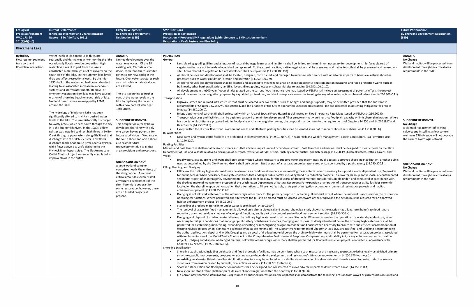
Ecological Processes/Functions WAC 173-26-201(3)(d)(i)(C)
Current Performance (Shoreline Inventory and Characterization Report - ESA Adolfson, 2011)
Likely Development By Shoreline Environment Designation (SED)
SMP Provisions Protection or Restoration Protection = Proposed SMP regulations (with reference to SMP section number) Restoration = Draft Restoration Plan Policy
Future Performance By Shoreline Environment Designation (SED)
Blackmans Lake
Hydrology Flow regime, sediment transport, and floodplain interaction
Water levels in Blackmans Lake fluctuate seasonally and during wet winter months the lake occasionally floods lakeside properties. High water levels result in part from the lake’s constricted outlet through a set of culverts on the south side of the lake. In the summer, lake levels drop and affect recreational uses. By the mid-1990s half of the watershed had been urbanized leading to an associated increase in impervious surfaces and stormwater runoff. Removal of emergent vegetation from lake may have caused erosion of shoreline beach on south side of lake. No flood hazard areas are mapped by FEMA around the lake. The hydrology of Blackmans Lake has been significantly altered to maintain desired water levels in the lake. The lake historically discharged to Swifty Creek, which runs south through the city into the Snohomish River. In the 1980s, a flow splitter was installed to direct high flows in Swifty Creek through a pipe system along 6th Street that discharges into the Pilchuck River. Low flows discharge to the Snohomish River near Cady Park, while flows above 1 to 2 cfs discharge to the Pilchuck River bypass pipe. The Blackmans Lake Outlet Control Project was recently completed to improve flows in the outlet.
AQUATIC Limited development over the water may occur. Of the 28 existing lots, 23 contain small docks, therefore, there is limited potential for new docks in the future. Overwater structures such as small public or private docks are allowed. The city is planning to further control the water levels in the lake by replacing the culverts with a flow control weir near 13th Street. SHORELINE RESIDENTIAL This designation already has a developed shoreline with only one parcel having potential for future subdivision. Wetlands on the south shore and north shore also restrict future redevelopment due to critical area provisions and protections. URBAN CONSERVANCY A large wetland complex comprises nearly the entirety of the designation. As a result, critical area rules severely limit any future development of the site. Potential does exist for some restoration, however, there are no funded projects at present.
PROTECTION General
• Land clearing, grading, filling and alteration of natural drainage features and landforms shall be limited to the minimum necessary for development. Surfaces cleared of vegetation that are not to be developed shall be replanted. To the extent practical, native vegetation shall be preserved and native topsoils shall be preserved and re-used on-site. Areas cleared of vegetation but not developed shall be replanted. (14.250.100.C.8)
• All shoreline uses and development shall be located, designed, constructed, and managed to minimize interference with or adverse impacts to beneficial natural shoreline processes such as water circulation, erosion and accretion (14.250.100.C.9)
• All shoreline uses and development shall be located and designed to minimize reliance on shoreline defense and stabilization measures and flood protection works such as bulkheads, other bank stabilization, landfills, levees, dikes, groins, jetties or substantial site re-grading (14.250.100.C.10).
• All development in the100-year floodplain designated on the current flood insurance rate map issued by FEMA shall include an assessment of potential effects the project would have on channel migration prepared by a qualified professional, and shall incorporate measures to mitigate any adverse impacts on channel migration (14.250.100.C.11).
Transportation • Highway, street and railroad infrastructure that must be located in or over water, such as bridges and bridge supports, may be permitted provided that the substantive
requirements of Chapter 14.255 SMC are satisfied, and the priorities of the City of Snohomish Shoreline Restoration Plan are addressed in designing mitigation for project impacts (14.250.200.C).
• Bridge abutments of earthen fill shall be located within an Area of Special Flood Hazard as delineated on Flood Insurance Rate Maps issued by FEMA (14.250.200.E). • Transportation uses and facilities shall be designed to avoid or minimize placement of fill or structures that would restrict floodplain capacity or limit channel migration. Where
transportation facilities are proposed within floodplains or channel migration zones; the proposal shall conform to the requirements of Chapters 14.255 and 14.270 SMC and this chapter (14.250.200.F).
• Except within the Historic Riverfront Environment, roads and off-street parking facilities shall be located so as not to require shoreline stabilization (14.250.200.G). In-Water Uses
• New dams and hydroelectric facilities are prohibited in all environments (14.250.120.P16) In-water fish and wildlife management, except aquaculture, is a Permitted Use (14.250.120).
Boating Facilities Marinas and boat launches shall not alter river currents such that adverse impacts would occur downstream. Boat launches and marinas shall be designed to meet criteria by the State Department of Fish and Wildlife relative to disruption of currents, restriction of tidal prisms, flushing characteristics, and fish passage (14.250.190.C) Breakwaters, Jetties, Groins, and Weirs
• Breakwaters, jetties, groins and weirs shall only be permitted where necessary to support water dependent uses, public access, approved shoreline stabilization, or other public uses, as determined by the City Planner. Groins shall only be permitted as part of a restoration project sponsored or co-sponsored by a public agency (14.250.270.3).
Filling, Grading, and Dredging • Fill below the ordinary high water mark may be allowed as a conditional use only when meeting these criteria: When necessary to support a water dependent use; To provide
for public access; When necessary to mitigate conditions that endanger public safety, including flood risk reduction projects; To allow for cleanup and disposal of contaminated sediments as part of an interagency environmental cleanup plan; To allow for the disposal of dredged material considered suitable under, and conducted in accordance with, the dredged material management program of the Washington Department of Natural Resources; For expansion or alteration of transportation or utility facilities currently located on the shoreline upon demonstration that alternatives to fill are not feasible; or As part of mitigation actions, environmental restoration projects and habitat enhancement projects (14.250.250.C.1-7).
• Dredging is not allowed waterward of the ordinary high water mark for the primary purpose of obtaining fill material except where the material is necessary for the restoration of ecological functions. Where permitted, the site where the fill is to be placed must be located waterward of the OWHM and the action must be required for an approved habitat enhancement project (14.250.300.G).
• Stockpiling of dredged material in or under water is prohibited (14.250.300.I) • The removal of gravel for flood management is allowed only after a biological and geomorphological study shows that extraction has a long-term benefit to flood hazard
reduction, does not result in a net loss of ecological functions, and is part of a comprehensive flood management solution (14.250.300.K). • Dredging and disposal of dredged material below the ordinary high water mark shall be permitted only: When necessary for the operation of a water dependent use; When
necessary to mitigate conditions that endanger public safety or fisheries resources; Dredging and disposal of dredged material below the ordinary high water mark shall be permitted for establishing, maintaining, expanding, relocating or reconfiguring navigation channels and basins when necessary to ensure safe and efficient accommodation of existing navigation uses when: Significant ecological impacts are minimized; The substantive requirement of Chapter 14.255 SMC are satisfied; and Dredging is maintained to the authorized location, depth and width; Dredging and disposal of dredged material below the ordinary high water mark shall be permitted for restoration projects associated with implementation of the Model Toxics Control Act or the Comprehensive Environmental Response, Compensation, and Liability Act; or any enhancement or restoration project; Dredging and disposal of dredged material below the ordinary high water mark shall be permitted for flood risk reduction projects conducted in accordance with Chapter 14.270 SMC (14.250. 300.D.1-5).
Shoreline Stabilization • Shoreline stabilization, including bulkheads and flood protection facilities, may be permitted where such measures are necessary to protect existing legally-established primary
structures, public improvements, proposed or existing water-dependent development, and restoration/mitigation improvements (14.250.270 footnote 1) • An existing legally established shoreline stabilization structure may be replaced with a similar structure when it is demonstrated there is a need to protect principal uses or
structures from erosion caused by currents, tidal action, or waves. (14.250.270 footnote 2). • Shoreline stabilization and flood protection measures shall be designed and constructed to avoid adverse impacts to downstream banks. (14.250.280.A). • New shoreline stabilization shall not preclude river channel migration within the floodway (14.250.280.B). • [To permit new shoreline stabilization] Using studies by qualified professionals, the applicant shall demonstrate the following: Erosion from waves or currents has occurred and
AQUATIC No Change Wetland habitat will be protected from development through the critical area requirements in the SMP. SHORELINE RESIDENTIAL No Change A planned replacement of existing culverts and installing a flow control weir near 13th Avenue will not degrade the current hydrologic network. URBAN CONSERVANCY No Change Wetland habitat will be protected from development through the critical area requirements in the SMP.
10

Ecological Processes/Functions WAC 173-26-201(3)(d)(i)(C)
Current Performance (Shoreline Inventory and Characterization Report - ESA Adolfson, 2011)
Likely Development By Shoreline Environment Designation (SED)
SMP Provisions Protection or Restoration Protection = Proposed SMP regulations (with reference to SMP section number) Restoration = Draft Restoration Plan Policy
Future Performance By Shoreline Environment Designation (SED)
Blackmans Lake
will continue to occur without the proposal; Erosion is not caused by upland conditions on the project site that, if corrected, would eliminate the need for shoreline stabilization; The ; The proposal is the minimum necessary to protect existing legally-established primary structures, existing water-dependent development, or projects for the restoration of ecological functions; Except for the protection of the shoreline requiring stabilization, the proposal would not preclude natural fluvial, hydrological and geomorphological processes ; Shoreline stabilization shall minimize the adverse impact to other properties to the maximum extent practical; Shoreline stabilization shall not be used to create new shoreland area; Shoreline stabilization shall not interfere with surface or subsurface drainage into the water body (14.250.280.E.1-8). Shoreline stabilization shall be designed so as not to create a need for shoreline stabilization elsewhere (14.250.80.H).
• Shoreline stabilization measures shall not be allowed within any designated floodway except as may be necessary to protect existing development or prevent serious impairment of channel function (14.250.280.I).
• Shoreline stabilization measures shall be consistent with the Integrated Stream Protection Guidelines (Washington departments of Fish and Wildlife, Ecology, and Transportation, 2003) (14.250.280.J).
• Flood protection facilities shall be consistent with the provisions of Chapter 14.270 SMC , the National Flood Insurance Program (NFIP), and the Integrated Stream Protection Guidelines (14.250.290A).
• Flood control dikes shall be landward of the designated floodway and any marshes or swamps directly interrelated and interdependent with the shoreline (14.250.290.B). Water Quality Retention of particulates, nutrient cycling, pathogens, delivery movement, and loss
Blackmans Lake is included on Ecology’s 303(d) list of impaired water bodies due to elevated fecal coliform levels. Blackmans Lake Creek (inlet to the lake) is considered a water of concern for fecal coliforms. Sources of fecal coliforms include abundant waterfowl and pets on the lake, stormwater runoff drains, and livestock in pastures upstream of the lake. Swifty Creek was found to have E. coli concentrations above state standards for primary contact recreation in 2003. Between 1996 and 2009, the levels of phosphorous in the upper waters of the lake were moderate but increasing, indicating that nutrients are being carried into the lake from the surrounding watershed. Phosphorous levels in the deeper waters have been decreasing. Ecology’s data indicate that the lake has recently met water quality standards for total phosphorous. However, toxic algae blooms likely caused by elevated phosphorus levels occurred in 2008 and 2009 in the lake's shallow waters. Water quality monitoring in the 1990s for tributaries to Blackmans Lake indicated seasonally high stream temperatures, low dissolved oxygen, and high nutrient concentrations. Low dissolved oxygen is possibly due to breakdown of emergent vegetation. There were no contaminated or hazardous waste sites identified within the Blackmans Lake shoreline planning area.
AQUATIC Limited development over the water may occur. Of the 28 existing lots, 23 contain small docks, therefore, there is limited potential for new docks in the future. Overwater structures such as small public or private docks are allowed. The city is planning to further control the water levels in the lake by replacing the culverts and installing a flow control weir near 13th Street. SHORELINE RESIDENTIAL This designation already has a developed shoreline with only one parcel having potential for future subdivision. Wetlands on the south shore and north shore also restrict future redevelopment due to critical area provisions and protections. URBAN CONSERVANCY A large wetland complex comprises nearly the entirety of the designation. As a result, critical area rules severely limit any future development of the site. Potential does exist for some restoration, however, there are no funded projects at present.
PROTECTION General
• All shoreline uses and development shall protect the quality and quantity of surface and ground water. New permits and development shall comply with the Department of Ecology stormwater Management Manual for Western Washington, as referenced I the City of Snohomish Engineering Design and Construction Standards (14.250.100.C.3).
• • No shoreline uses and development shall release solid or liquid waste, oil, unwanted chemicals, hazardous materials, or untreated effluent to any water bodies or shorelands
(14.250.100.C.4). • Heating and cooling equipment may not be placed in waters of the state (14.250.100.C.5). • Land clearing, grading, filling and alteration of natural drainage features and landforms shall be limited to the minimum necessary for development. To the extent practical,
native vegetation shall be preserved and native topsoils shall be preserved and re-used on-site. Areas cleared of vegetation but not developed shall be replanted (14.250.100.C.8).
• All shoreline uses and development shall be located, designed, constructed, and managed to minimize interference with or adverse impacts to beneficial natural shoreline processes such as water circulation, erosion and accretion (14.250.100.C.9)
• All shoreline uses and development shall be located and designed to minimize reliance upon shoreline defense and stabilization measures and flood protection works such as bulkheads, other bank stabilization, landfills, levees, dikes, groins, jetties or substantial site re-grading (14.250.100.C.10).
• All debris, overburden and other waste materials from construction shall be disposed of in such a way as to prevent their entry by erosion from drainage, high water or other means into any water body (14.250.100.C.12).
• As provided by WAC 173-26-186(8), land development, land uses, and modifications within the shoreline jurisdiction shall not result in a net loss of shoreline ecological functions and processes. Mitigation for impacts resulting from development, uses, and modifications shall comply with the priorities specified in the Shoreline Restoration Plan and the substantive requirements of Chapter SMC 14.255 SMC (14.255.100.A)
Industrial • Outdoor storage areas shall be designed in accordance with Chapter 15.16 SMC and the Snohomish Engineering Design and Construction Standards (14.250.160.B) • Log storage shall not be permitted in waters of the State where water quality standards cannot be met or where log storage precludes the public’s use and navigation of waters
of the State (14.250.160.C.2) • Bark and wood debris from mill operations shall be kept out of water bodies (14.250.160.GC.4).
Residential Development • Residential development over water is prohibited (14.250.120.8)
Boating Facilities • Marinas shall have facilities for handling wastes typically generated by marina patrons and visitors. Marinas shall not discharge or release any waste, treated or untreated, into
the body of water on which they are located. Oil and gas handling systems shall be designed to minimize potential oil and gas spills. Marinas shall have provisions available for containment and cleanup of such spills (14.250.190.D4)
Shoreline Habitat and Natural Systems Enhancement Projects • As specified by the critical areas report, plans for habitat restoration or enhancement shall focus on restoring the most-critical ecological functions. In approving any
compensatory habitat enhancement plan, the City Planner shall consider factors such as changes in surface water runoff rates and water quality, current vegetative conditions, and other potential limiting conditions that could impact water quality functions provided by the critical area (14.250.320.I).
• Enhancements should generally focus on offsetting project impacts but may focus on restoring other critical ecological functions in the shoreline that have been lost or diminished (such as the placement of large woody debris in water or restoring riparian vegetation (14 250.320.I.1)
• The City Planner shall determine whether a mitigation measure proposed to provide a broader ecological benefit may be substituted for one that would only offset the impacts of an individual development (14.250.320.I.2)
• Where development is proposed within the required shoreline buffer, compensatory mitigation shall be provided. The City Planner shall not authorize development within a required shoreline buffer unless appropriate mitigation is provided (14.250.320.H).
• Shoreline Stabilization
• Material that may release hazardous substances shall not be used for shoreline stabilization (14.250.280.F).
AQUATIC No Change Water quality will likely not be degraded by new development within the lake since critical area provision applicants would be required to meet stormwater management standards and develop an erosion and sedimentation control program. SHORELINE RESIDENTIAL No Change Water quality will likely not be degraded by new development since applicants would be required to meet stormwater management standards and develop an erosion and sedimentation control program. Existing development and wildlife will continue to contribute to water quality problems. URBAN CONSERVANCY No Change Water quality will likely not be degraded by new development since applicants adjacent to or within critical areas would be required to meet stormwater management standards and develop an erosion and sedimentation control program. CAO requires buffers on entire shoreline.
11

Ecological Processes/Functions WAC 173-26-201(3)(d)(i)(C)
Current Performance (Shoreline Inventory and Characterization Report - ESA Adolfson, 2011)
Likely Development By Shoreline Environment Designation (SED)
SMP Provisions Protection or Restoration Protection = Proposed SMP regulations (with reference to SMP section number) Restoration = Draft Restoration Plan Policy
Future Performance By Shoreline Environment Designation (SED)
Blackmans Lake
LWD, Organics and Habitat Maintain characteristic plant community and source of large woody debris (LWD)
Most natural vegetation has been removed in areas of residential and park development to provide views of and access to the water. Large woody debris has been removed for construction of docks, bulkheads, and landscaping. A survey of aquatic plants in Blackmans Lake in September 2009 identified both native and invasive water lilies. Patches of the invasive species, fragrant water lily, were dominant on the northern shore of the lake, while the native species, yellow water lily, was prevalent on the southern shoreline. There are also large waterfowl concentrations on the lake. Approximately 21 acres of wetland are mapped near the lake’s inlet and outlet streams in the shoreline planning area Barriers such as perched culverts, long pipes, and poor water quality in Swifty Creek prevent fish passage into the stream from the Snohomish and Pilchuck Rivers. Blackmans Lake supports game fish such as rainbow trout, largemouth bass, yellow perch, and brown bullhead. WDFW stocks the lake with rainbow trout. Introduced carp prey upon and displace other fish species, and management includes periodic killing of fish to re-establish desired game fish populations.
AQUATIC Limited development over the water may occur. Of the 28 existing lots, 23 contain small docks, therefore, there is limited potential for new docks in the future. Overwater structures such as small public or private docks are allowed. The city is planning to further control the water levels in the lake by replacing the culverts and installing a flow control weir near 13th Street. SHORELINE RESIDENTIAL This designation already has a developed shoreline with only one parcel having potential for future subdivision. Wetlands on the south shore and north shore also restrict future redevelopment due to critical area provisions and protections. URBAN CONSERVANCY A large wetland complex comprises nearly the entirety of the designation. As a result, critical area rules severely limit any future development of the site. Potential does exist for some restoration, however, there are no funded projects at present.
PROTECTION General
• The use of chemicals to control invasive aquatic weeds is prohibited, except that milfoil may be removed using chemicals, provided that the chemicals are applied by a licensed pesticide applicator and approved for aquatic use (14.250.100.C.5).
• All shoreline uses and development shall be located, designed, constructed and managed to avoid disturbance of, or minimize adverse impacts to, protect fish and wildlife habitat conservation areas. Where avoidance of adverse impacts is not practicable, the City Planner, in consultation with state resource management agencies and federally recognized tribes, may require that mitigation measures to protect species and habitat functions be implemented (14.250.100.C.7).
• Land clearing, grading, filling and alteration of natural drainage features and landforms shall be limited to the minimum necessary for development. To the extent practical, native vegetation shall be preserved and native topsoils shall be preserved and re-used on-site. Areas cleared of vegetation but not developed shall be replanted (14.250.100.C.8).
Agriculture • Creation of new agricultural structures for accessory uses on agricultural lands are subject to the requirements for structure setbacks and vegetation management by this
chapter, and shall be located and designed to ensure no net loss of ecological function (14.250.130.C). Commercial
• Commercial uses that are not water-dependent or water-related shall be prohibited on Urban Conservancy Shorelines except for restaurants, campgrounds, group camps, and similar recreational facilities; hunting and fishing and other private clubs; game preserves and private parks; and commercial uses in historical structures, where the use: a) is permitted in the underlying zoning; b) is located outside the shoreline buffer required by this chapter; and c) does not result in unmitigated adverse environmental impacts(14.250.120. 4).
• Except for commercial structures that are dependent on direct, contiguous access to the water, all commercial structures shall be located outside the shoreline buffer area prescribed by this chapter (14.250.150.A)
Cultural • Lighting of outdoor facilities within the shoreline environment shall be designed and configured to avoid light spill into regulated critical areas and their buffers or onto
adjacent properties. Where light spill cannot be avoided, such lighting shall be the minimum necessary to achieve the intended purpose (14.250.180.). Industrial
• Logs: Except where no practical alternative exists, log storage shall occur on land; Free-fall dropping of logs into water is prohibited; Logs shall not be dumped, stored, or floated in areas where grounding will occur (14.250.160.C.1, 3, 5).
Park/Recreation
• Golf courses, playing fields, and other large areas devoted to athletic activities shall be allowed only outside of the buffers required by this chapter. (14.250.120. 11). Residential
• Non-water-dependent accessory structures and facilities such as sheds, gazebos, swimming pools, and driveways shall not be located in shoreline buffer areas (14.250.170.A.3).
• Stairs and paths to a dock or beach may be allowed in shoreline buffer area, but shall be limited to the minimum necessary to provide pedestrian access (14.250.170.A.4). Public Marinas and Boat Launches
• Marinas shall be designed to include native vegetation where feasible and practical (14.250.190.F). • Parking for boat launches and marinas shall be located upland of shoreline buffer areas (14.250.190.J).
Transportation • Highway, street and railroad infrastructure that must be located in or over water, such as bridges and bridge supports, may be permitted provided that the substantive
requirements of Chapter 14.255 SMC are satisfied, and the priorities of the City of Snohomish Shoreline Restoration Plan are addressed in designing mitigation for project impacts (14.250.200.C).
• Major roads and railroads shall cross shoreline areas by the shortest, most direct route feasible, unless such route would cause significant environmental damage (14.250.200.B)
• New off-street parking shall be located outside of required critical area buffers (14.250.200.H). • Exterior lighting from parking areas shall be designed to avoid or minimize light spill into regulated critical areas and their buffers (14.250.200.K).
Utilities • Utility transmission and distribution infrastructure that cannot be located below ground and outside the shoreline jurisdiction shall be located as far landward as feasible to
preserve public views (14.250.210C). • Where feasible utility lines and facilities shall be located underground unless long-term environmental benefit is demonstrated through the use of aerial utility lines
(14.250.210.B). • If crossing beneath a river or stream, utilities shall be designed to avoid river bed/streambed mobilization and adverse environmental impacts in general. Such utility lines
shall be placed in a sleeve or conduit to facilitate replacement without additional boring or excavation (14.250.210.F.3). In-Water Uses
• New dams and hydroelectric facilities are prohibited in all environments (14.250.120.). • [In-water and over-water highway and street facilities] may be permitted as conditional uses where: a) there is no feasible upland location; and b) the substantive
requirements of Chapter 14.255 SMC are satisfied; and c) the priorities of the City of Snohomish Shoreline Restoration Plan are addressed in the project’s mitigation plan (14.250.120.17).
Boating Facilities • Marinas and boat launches shall not alter river currents such that adverse impacts would occur downstream. Boat launches and marinas shall be designed to meet criteria by
AQUATIC No Change Establishing a lacustrine management zone for non-water-dependent uses will result in protection of existing vegetation. SHORELINE RESIDENTIAL No Change Establishing a lacustrine management zone for non-water-dependent uses will result in protection of existing vegetation. Additional habitat safeguards are provided via critical area protections for wetlands. URBAN CONSERVANCY No Change Establishing a lacustrine management zone for non-water-dependent uses will result in protection of existing vegetation. Additional habitat safeguards are provided via critical area protections for wetlands.
12

Ecological Processes/Functions WAC 173-26-201(3)(d)(i)(C)
Current Performance (Shoreline Inventory and Characterization Report - ESA Adolfson, 2011)
Likely Development By Shoreline Environment Designation (SED)
SMP Provisions Protection or Restoration Protection = Proposed SMP regulations (with reference to SMP section number) Restoration = Draft Restoration Plan Policy
Future Performance By Shoreline Environment Designation (SED)
Blackmans Lake
the State Department of Fish and Wildlife relative to disruption of currents, restriction of tidal prisms, flushing characteristics, and fish passage (14.250.190.C). • New residential lots created adjacent to Blackmans Lake shall provide for common or shared dock(s) in lieu of individual docks for each lot (14.250.170.D). • Marinas shall be designed to include native vegetation where feasible and practical (14.250.190.F). • Parking for boat launches and marinas shall be located upland of shoreline buffer areas (14.250.190.J).
Breakwaters, Jetties, Groins, and Weirs • Breakwaters, jetties, groins and weirs shall only be permitted where necessary to support water dependent uses, public access, approved shoreline stabilization, or other
public uses, as determined by the City Planner. Groins shall only be permitted as part of a restoration project sponsored or co-sponsored by a public agency (14.250.270.3). Filling, Grading, and Dredging
• Fill below the ordinary high water mark may be allowed as a conditional use only when meeting these criteria: When necessary to support a water dependent use; To provide for public access; When necessary to mitigate conditions that endanger public safety, including flood risk reduction projects; To allow for cleanup and disposal of contaminated sediments as part of an interagency environmental cleanup plan; To allow for the disposal of dredged material considered suitable under, and conducted in accordance with, the dredged material management program of the Washington Department of Natural Resources; For expansion or alteration of transportation or utility facilities currently located on the shoreline upon demonstration that alternatives to fill are not feasible; or As part of mitigation actions, environmental restoration projects and habitat enhancement projects (14.250.250.C.1-7).
• Dredging and disposal of dredged material below the ordinary high water mark shall be permitted for restoration projects associated with implementation of the Model Toxics Control Act or the Comprehensive Environmental Response, Compensation, and Liability Act; or any enhancement or restoration project (14.250.300.D.4).
• Disposal of dredged material shall be allowed only in approved disposal sites (14.250.300.H). Shoreline Habitat and Natural Systems Enhancement Projects
• Non-native vegetation may be removed as part of a restoration or enhancement project if replacement plantings will provide greater benefit to shoreline ecological processes. Exiting non-native vegetation may be retained unless otherwise required to be replaced as part of an enhancement associated with development on the property (14.250.320.E).
• Vegetation and vegetated areas within designated critical areas and their required buffers shall be delineated, preserved, enhanced, restored, etc., so as to protect or improve shoreline ecological processes and functions. Such measures shall be as prescribed by standards within the SMP, including integrated critical areas standards, and/or by a critical areas report prepared pursuant to Chapter 14.255 SMC (as well as critical areas protections standards included directly within the SMP). Proposed SMC 14.250.320 (Habitat and Vegetation Management) and 14.250.330 (Shoreline Buffers) designate all shorelines as habitat conservation areas, and establishes a system of shoreline buffers and conservation standards to protect habitat and other functions provided by shoreline riparian areas. In addition, SMC 14.250.320 integrates protections for flood hazard areas (Chapter 14.270 SMC) and geologically hazardous areas (Chapter 14.275 SMC) where they occur in shoreline jurisdiction. Proposed SMC 14.250.350 (Shoreland Wetlands) incorporates new standards to ensure protection of wetlands consistent with current guidance from Ecology.
• As specified by the critical areas report, plans for habitat restoration or enhancement shall focus on restoring the most-critical ecological functions. In approving any compensatory habitat enhancement plan, the City Planner shall consider factors such as changes in surface water runoff rates and water quality, current vegetative conditions, and limiting conditions (ambient noise, light and glare, activity levels, etc.) (14.250.320.I).
• Enhancements should generally focus on offsetting project impacts but may focus on restoring other critical ecological functions in the shoreline that have been lost or diminished (such as the placement of large woody debris in water or restoring riparian vegetation (14 250.320.I.1)
• The City Planner shall determine whether a mitigation measure proposed to provide a broader ecological benefit may be substituted for one that would only offset the impacts of an individual development (14.250.320.I.2)
• Where development is proposed within the required shoreline buffer, compensatory mitigation shall be provided. The City Planner shall not authorize development within a required shoreline buffer unless appropriate mitigation is provided (14.250.320.H).
• Shoreline stabilization, including bulkheads and flood protection facilities, may be permitted where such measures are necessary to protect existing legally-established primary structures, public improvements, proposed or existing water-dependent development, and restoration/mitigation improvements (14.250.270. 1)
• Shoreline stabilization shall be design and constructed consistent with the critical areas report required by Chapter 14.255 SMC. Where possible, shoreline vegetation shall be preserved (14.250.280.C).
• Mitigation measures shall maintain or augment existing shoreline processes and critical fish and wildlife habitat so that no net loss or function of riparian habitat will occur (14.250.280.E.5).
13