meeting - executive committee · executive committee meeting #2/03 friday, april 25, 2003 minutes...
TRANSCRIPT

INDEX TO
EXECUTIVE COMMITTEE MEETING #2/03
Friday, April 25, 2003
MINUTESMinutes of Meeting #1/03, held on March 7, 2003 67
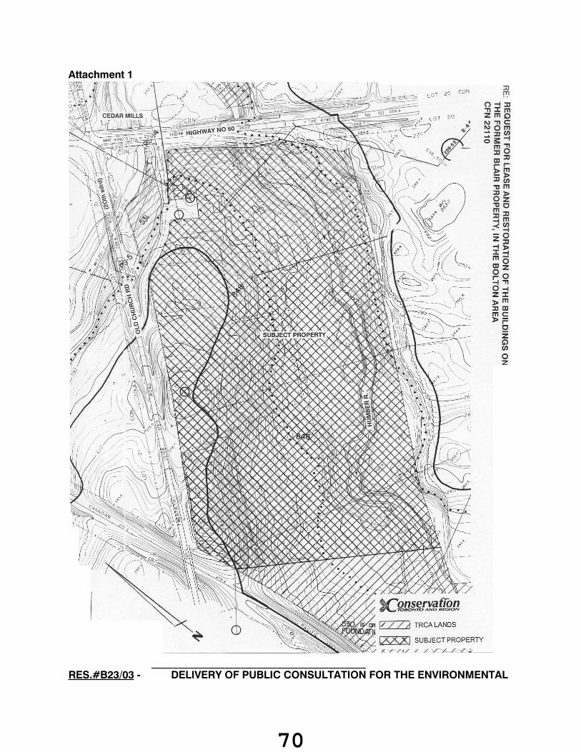
REQUEST FOR LEASE AND RESTORATION OF THE BUILDINGS ON THE FORMER BLAIRPROPERTY, IN THE BOLTON AREA 67
DELIVERY OF PUBLIC CONSULTATION FOR THE ENVIRONMENTAL ASSESSMENTS FORTHE NATURALIZATION AND FLOOD PROTECTION FOR THE LOWER DON RIVER 71
REGIONAL MONITORING NETWORK PROGRAM - WATER QUALITY COMPONENT 74
POTENTIAL APPEAL TO OMB OF R. JOHNSON MINOR VARIANCE APPROVAL 76
THE REGIONAL MUNICIPALITY OF YORKRequest for a Permanent Easement for the York-Peel Feedermain, City of Vaughan, CFN 33995 77
ONTARIO REGULATION 158Alexandris, Bob 99, 100Brown, Colin 95Camp Villas Corp. 106Canadian Tire Corporation 101Carson, Bill 81Dunster Management (Old Paisley Mews) 97Enbridge Gas Distribution Inc. 103Henderson, Catherine 92Highcastle Homes - Ebenezer Tract 113Kim, Mary 86Loblaw Properties Limited 104Marinucci, Guido and Joanne 93Marshall Homes 109Nicholson, Derek 85Pegasus Group 89Pinto, Jose Antonio 82

Piscioneri, Joe 112Putyra, Tadevsz (Tad) 83Schultz, Mary 87Tito, Mike 94Toronto, City of 88, 90, 110Vidovic, Joseph 98Woodbine Mackenzie Developments Limited 107
THE CITY OF TORONTO VALLEY AND SHORELINE REGENERATION PROJECT (2002-2006)220 Wicksteed Avenue (TREMCO Ltd.) 117
MOE/TRCA MEMORANDUM OF UNDERSTANDING 118
VEHICLE ACQUISITIONS 120
ASHBRIDGE'S BAY BREAKWATER PROJECT 121

MEETING OF THE EXECUTIVE COMMITTEE #2/03April 25, 2003
The Executive Committee Meeting #2/03, was held in the South Theatre, Black Creek Pioneer Village, on Friday, April 25, 2003. The Chair Dick O'Brien, called the meeting to order at 9:08 a.m.
PRESENTMaria Augimeri MemberLorna Bissell MemberMichael Di Biase MemberIrene Jones MemberJim McMaster Vice ChairDick O'Brien ChairGerri Lynn O'Connor Member
REGRETSRon Moeser Member
RES.#B21/03 - MINUTES
Moved by: Jim McMasterSeconded by: Gerri Lynn O'Connor
THAT the Minutes of Meeting #1/03, held on March 7, 2003, be approved.CARRIED
_________________________________________
SECTION I - ITEMS FOR AUTHORITY ACTION
RES.#B22/03 - REQUEST FOR LEASE AND RESTORATION OF THE BUILDINGS ON THE FORMER BLAIR PROPERTY, IN THE BOLTON AREACFN 22110. The Authority is in receipt of a proposal from Richardson Technologies Inc., of the Town of Bolton, to lease and restore the buildings on the Former Blair Property in the Town of Bolton, and to use this location as their new international marketing headquarters.
Moved by: Lorna BissellSeconded by: Irene Jones
67

THE EXECUTIVE COMMITTEE RECOMMENDS THAT the request for the lease and restoration of the Former Blair Property be referred to Authority staff for review and further discussions with Richardson Technologies Inc.
AND FURTHER THAT a report recommending further action in this matter be brought to the Executive Committee at the earliest opportunity.
CARRIEDBACKGROUNDIn June of 1984 the Authority acquired 40.58 acres of land in the Town of Caledon from the Estate of Sidney Blair. Situate on the subject land at the date of acquisition were a number of improvements including the main house, the church house, carriage house, two barns, a cottage, a number of smaller outbuildings, together with a small cemetary. This property has been rented since 1984 and became vacant the summer of 2002. Authority staff have been attempting to find a suitable tenant for this property but have had difficulty in finding a tenant due to the size of the property. The main home is approximately 3000 square feet, and is very costly to maintain. During this time we time we received a request from Richardson Technologies Inc.
Richardson Technologies Inc. (RTI) a company that manufactures a line of microscopes ranging from education field microscopes to state of the art medical research systems and markets advanced scientific instruments and products internationally.
RTI is a Canadian company founded in 1996 to explore new technologies to understand cancer and its initiation and spread. RTI now has an office in Bolton, a suite of research labs at the Hospital for Sick Children in Toronto and a manufacturing plant in Calgary Alberta. Tim Richardson the owner and founder of RTI lives in the Albion Hills area and has been active in local conservation projects.
It is RTI's request to restore and lease this property for their corporate marketing head quarters. The presence of the river, the natural surroundings and the heritage nature of the site makes is what makes this the ideal setting for RTI' s purposes.
RTI has had some preliminary discussions with the Town of Caledon regarding the proposed use and it appears that the Town will support this activity.
During the past few years the Authority has entered into similar arrangements with Catherine Tredway and Barn Owl Designs for the restoration and maintenance of an historic dwelling located in Markham and also with the Yeoman Rugby Club for the restoration of the Former Peachey Dwelling in the City of Brampton. To date the dwellings have been restored to the satisfaction of the Authority, with no cost to the Authority.
RATIONALE A number of discussions have been held with representatives of RTI. There is potential for an arrangement to be negotiated that would provide for:
(a) Restoration and maintenance of the main house, church house, and carriage house to the satisfaction of the Authority;
68

(b) All costs associated with the Property being paid by the tenants;
(c) Create a long term relationship with a firm whose environmental outlook is similar to the Authority's;
(d) An opportunity to restore a local landmark back to its former condition and opportunity for educational partnerships with the Albion Hills Field Centre.
Staff is seeking to continue negotiations on the basis noted above and will report to the Executive Committee when a satisfactory proposal is achieved.
Report prepared by: Lori Colussi, extension 5303For Information contact: Lori Colussi, extension 5303Date: March 24, 2003Attachments: 1
69
Attachment 1
_________________________________________ RES.#B23/03 - DELIVERY OF PUBLIC CONSULTATION FOR THE ENVIRONMENTAL
70
ASSESSMENTS FOR THE NATURALIZATION AND FLOOD PROTECTION FOR THE LOWER DON RIVERTo authorize Authority officials in enter into a letter of understanding or other instrument with the City of Toronto to assist the TRCA with the public consultation component of the Environmental Assessments for the Naturalization and Flood Protection for the Lower Don River
Moved by: Lorna BissellSeconded by: Irene Jones
THE EXECUTIVE COMMITTEE RECOMMENDS THAT Authority officials be authorized to enter into a letter of understanding or other instrument with the City of Toronto to assist the TRCA staff with the delivery and documentation of the public consultation component of the Environmental Assessments for the Naturalization and Flood Protection for the Lower Don River subject to the satisfaction of the Authority's solicitors, Gardiner Roberts LLP and the approval of the Toronto Waterfront Revitalization Corporation (TWRC).
CARRIEDBACKGROUNDAt Authority Meeting #9/02, Resolution #A246/02 was approved as follows:
"WHEREAS the Toronto Waterfront Revitalization Corporation (TWRC) has requested that the Toronto and Region Conservation Authority (TRCA) enter into a delivery agreement with TWRC to undertake certain works for the Naturalization and Flood Protection for the Lower Don River;
AND WHEREAS it is in the interest of TRCA under its authority and mandate as set out in the Conservation Authorities Act (R.S.O. 1990, c. 27) to enter into such an agreement;
THEREFORE LET IT BE RESOLVED THAT the Authority agrees to enter into the Toronto Waterfront Revitalization - Naturalization and Flood Protection For The Lower Don Delivery Agreement, subject to all terms and conditions being finalized in a manner satisfactory to Authority staff and the Authority’s solicitors, Gardiner Roberts LLP;
AND FURTHER THAT Authority officials be authorized and directed to take all necessary actions as may be required, including the signing of documents, for the execution of the Delivery Agreement."
On December 6, 2002 the Delivery Agreement was signed between the TWRC and the TRCA.
A summary of key elements in this draft has been provided.
71

PhasingThe Delivery Agreement will be conducted in two phases due to the fact that the ultimate scope, cost and scheduled completion of the Project is uncertain at the time of signing this Agreement. The first phase pertains to the determination of the scope, budget and schedule of the environmental assessments for the naturalization and flood protection for the lower Don River and various preliminary activities in connection therewith. The first phase workplan was submitted to the TWRC in January, 2002. The second phase pertains to hiring the consultants, the carrying out of the environmental assessments (EAs) and the functional design.
Two EA ApproachThe Delivery Agreement recognizes that the Authority will be the Proponent to conduct two mutually independent EAs to achieve the objectives set out in the Contribution Agreement between the TWRC and the three levels of Government.
The first EA will identify a preferred alternative to providing flood protection along the west bank of the Lower Don River for the downtown core of Toronto, which includes all of the West Donlands. This EA study will address provincial EA requirements using the Conservation Authority Class EA for Remedial Flood and Erosion Control Projects. This study will also address the requirements under the Canadian Environmental Assessment Act (CEAA) through an Environmental Screening Report.
The second EA will identify a preferred alternative (or range of preferred alternatives pending a resolution for the location of the Gardiner Expressway) to provide flood protection to the Portlands and East Donlands, while naturalizing the Lower Don River from the mouth to Riverdale Park. The naturalization components of the study will also provide for an attractive, multi-use amenity for the public. This EA study will address the requirements under the Ontario Environmental Assessment Act (EAA) using an individual EA format. This study will also address the requirements under the CEAA through an Environmental Screening Report.
Maximum Allowable CostRefers to the maximum amount of costs to be funded to the TWRC by the Levels of Government for and in respect of the Project as set out in the Contribution Agreement. For the Lower Don River studies, this maximum allowable cost is $2 million. There are limited provisions for the increase in this amount. Following the determination of the consulting costs the TRCA may be required to review with the TWRC this maximum allowable cost.
ObligationsThe TRCA is to ensure that:
the Authorized Activities are carried out in accordance with the terms of this Agreement and in compliance with all Laws and Regulations and all Contract Documents;all Third Party Contracts observe and perform their obligations under the terms of this Agreement;all other Governmental Authorizations , and Agreements necessary to complete the authorized Activities are obtained; all contracts exceeding $75,000.00 to be entered between the TRCA and an Approved Consultant be awarded following a competitive process;all tender documents, requests for proposals, Third Party Contracts and appointments of consultants receive authorization from the TWRC; and
72

maintain up-to-date records and documents for the Authorized Activities.
Schedules and ReportsThe Delivery Agreement stipulates that the TRCA is to undertake an extensive reporting process which includes undergoing periodic audits by the TWRC and Levels of Government. TRCA will establish and maintain a Delivery Plan. Once a month, the TRCA will submit to the TWRC: a Master Project Sequencing and Schedule Plan (MPSSP); a Monthly Progress Report with a description of any deviations between the MPSSP and Progress Report; and Payment Requests.
Payment ProcessThe TRCA is entitled to submit a written request for payment of incurred costs in accordance to the Project Budget once a month. The TWRC has 10 business days to review payment request and a further 10 business days to provide payment. In case of sudden, unexpected costs incurred as a component of the Authorized Activities, the TRCA can negotiate for a payment advance, within the scope of the Project Budget.
Ownership and CopyrightAll data acquired, developed, prepared, conceived of or produced in the performance of this Agreement shall be the sole property of the TWRC. However, the TWRC grants the TRCA an irrevocable, perpetual and royalty-free license to use the data in connection with the Project or other projects of the TRCA provided such use is not for commercial or revenue generating purposes, and that any disclosure of the data will be subject to reasonable confidentiality requirements of the TWRC.
TimeframeThe timeframe for this Delivery Agreement will be dependent upon the completion of the two Environmental Assessments which is expected to take an absolute minimum of three years.
RATIONALEThe City of Toronto approached the TRCA regarding the development of a comprehensive approach to public consultation following the establishment of the Interim Waterfront Revitalization Corporation. The TRCA have continued to work with the Public Consultation and Community Outreach Unit, the Environmental Services Section of the Works and Emergency Services Department. The City staff have provided to the TRCA a proposed detailed work plan and cost estimates for the provision of assistance in delivery and documentation of the public consultation elements of the two EAs. The initial estimate in 2001 was for approximately $150,000 including dispursements. Since that time, additional requirements have been identified including the formation of a Community Liaison Committee for the Class EA. The decision to carry out two separate EAs will also require additional meetings and documentation with an attendant increase in cost.
73

Given the extensive public process required, the high profile of this priority project, and the initial consultation that has been undertaken through the secondary plan process and related activities, the proposal of the City Public Consultation and Community Outreach Unit will assist in a seamless approach to this work and ensure close TRCA/City coordination. The cost estimates are based on only direct costs. Disbursements may be part of the letter of intent or may be covered directly by the TRCA. Every effort will be used by both the City and the TRCA to minimize costs while ensuring all requirements are met under the provisions of the provincial and federal environmental assessments. In addition, the TWRC also has a public consultation policy that must also be met.
There is a requirement that the three levels of government will need to agree to this approach. Early indications are that this approval will be forthcoming. In order to move to the next step in this work, staff are seeking Authority direction to work with the City to assist in the delivery and documentation of the public consultation component of this work.
WORK TO BE COMPLETEDPrior to Delivery Plan finalization the following activities require completion:
Finalize Draft Public Consultation Program for the Class EA and the Individual EA for the Delivery Agreement for the Naturalization and Flood Protection of the Lower DonDevelop a letter of intent or other instrument as required by the TWRC
Report prepared by: Adele Freeman, extension 5238For Information contact: Adele Freeman, extension 5238Date: March 25, 2003
_________________________________________
RES.#B24/03 - REGIONAL MONITORING NETWORK PROGRAM - WATER QUANTITY COMPONENTStream flow and precipitation monitoring within the Authority's Regional Monitoring Network Program.
Moved by: Lorna BissellSeconded by: Irene Jones
THE EXECUTIVE COMMITTEE RECOMMENDS THAT the firm of Ontario Hydrometric Services Limited be retained for a period of one year to construct, maintain, monitor and archive stream flow data at 14 locations and precipitation data at 18 locations as part of the Authority's Regional Monitoring Network Program.
CARRIED
74

BACKGROUNDThe Authority has undertaken, with the support of our member municipalities, to develop and implement a regional monitoring network within our area of jurisdiction. The network has been designed to develop a comprehensive, integrated and coordinated approach to environmental monitoring that fulfills the watershed monitoring and reporting needs of the Toronto and Remedial Action Plan, the TRCA and those of the individual watershed and waterfront councils and alliances, while furthering the interests of municipal, provincial and federal partners. A number of areas, requiring specific monitoring needs, were included in the development of the network. These areas included Aquatic Habitat and Species/Fluvial Geomorphology, Terrestrial Natural Heritage, Surface Water Quality, Surface Water Quantity (Flow and Precipitation), Ground Water, and Air Quality.
The surface water quantity component specifically builds upon the Authority's existing stream gauge, rain gauge and snow course networks as these networks relate to the objectives of the Authority's water management activities. In 2003, four new stream gauges and six new precipitation stations are proposed. In addition to the new stations, the existing network of 10 stream flow gauges and 12 precipitation gauges will require continues maintenance and operation.
RATIONALEHistorically, the vast majority of gauging in the Province has been carried out by Environment Canada, either through their Water Survey Division or through Atmospheric Environment Services. Today, the availability of private contractors who undertake water quantity and precipitation monitoring work is very limited. While some consulting firms offer a service of gathering flow data in storm and sanitary sewers, very few can monitor open channel flow to Environment Canada standards.
Within this area of Ontario, only one private firm, Ontario Hydrometric Services Limited (OHS), is able to offer this comprehensive service. OHS has worked with the TRCA over the past six years to maintain and operate our water quantity networks. During this time, OHS has worked very closely with TRCA staff and has developed a clear understanding of our monitoring needs and objectives, has become very familiar with the location of our existing network stations, and has been able to provide technical expertise regarding various types of monitoring equipment available on the market. OHS has also worked with a number of other Conservation Authorities and local municipalities in Southern Ontario, including a few municipalities within the TRCA jurisdiction. This arrangement has allowed for, and will continue to facilitate the development of partnership opportunities and cost-sharing agreements.
FINANCIAL DETAILSPreliminary cost estimates, as prepared by OHS, for the 2003 monitoring year include:
Continued operation and maintenance of existing stream gauges and implementation of new stream gauges: $85,000.00
Continued operation and maintenance of existing precipitation gauges and implementation of new precipitation gauges: $30,000.00
Total Proposed Cost: $115,000 (inclusive of applicable taxes)
75

OHS will be responsible for site reconnaissance, construction and implementation of housing units at each station, monthly data retrieval and analysis, and annual maintenance requirements. Costs associated with equipment purchases for the new stations (4 stream gauge stations and 6 precipitation stations) were primarily covered under the 2002 budget with one station's equipment costs being covered in the 2003 budget. Costs associated with machine time to install the gauge housing will be undertaken using the TRCA approved heavy equipment supplier.
Funding for the 2003 monitoring season is available within in accounts 124-20 (Regional Monitoring Network) and 122-46 (Region of Durham Capital Budget).
Report prepared by: Patricia Lewis, extension 5218For Information contact: Patricia Lewis, extension 5218Date: March 18, 2003
_________________________________________
RES.#B25/03 - POTENTIAL APPEAL TO OMB OF R. JOHNSON MINOR VARIANCE APPROVALStaff wish to advise Executive Committee members that they have appealed to the Ontario Municipal Board a minor variance granted to a City of Pickering landowner which may not be in conformity with the Oak Ridges Moraine Conservation Plan. The appeal had to be filed by April 8, 2003 so staff is seeking Executive Committee support for this action.
Moved by: Gerri Lynn O'ConnorSeconded by: Irene Jones
THE EXECUTIVE COMMITTEE RECOMMENDS THAT the appeal to the Ontario Municipal Board of the S. and R. Johnson minor variance be approved;
THAT staff be authorized to retain legal counsel in support of this appeal;
AND FURTHER THAT staff continue to pursue the resolution of Authority issues in cooperation with relevant parties prior to the Hearing.
CARRIED
76

BACKGROUNDThe City of Pickering Committee of Adjustment approved file P/CA 56/00 for S. and R. Johnson to provide relief from Zoning By-law 3037 which states that no person shall erect or use any building on a lot which does not front on an opened public street maintained at public expense. The applicant is seeking to use the unopened Uxbridge - Pickering Town line as the access to the property, under agreement with the City of Pickering, and construct a single family dwelling on the property. This portion of the unopened Town line is currently used as part of the Trans Canada Trail. It is also designated through the Oak Ridges Moraine Conservation Plan (ORMCP) as Natural Core Area. The driveway access would also require "development and site alteration" within Key Natural Heritage Features (an ANSI and a significant woodland), which is prohibited by the ORMCP. The applicant's consultant has prepared an ORMCP conformity assessment report stating that the application is in conformity with the ORMCP, in part because the road exists and no additional works would be required. However, as part of the agreement required between the landowner and the City of Pickering, a condition of the approval, the access road must be upgraded to meet emergency vehicle access standards.
Current Status Both the City of Pickering and Durham Conservation have appealed the decision. The TRCA did not object to the application but since we had only one day's notice to review it and submit our comments, we did request additional time to assess the implications of the ORMCP. Due to the OMB filing deadline of April 8, 2003, Executive Committee direction was not possible in advance due to the cancellation of the April 4, 2003 Meeting.
Staff's main issue relates to the expanded road requiremnts and the potential environmental impact this might have. Staff feel other options should be pursued.
Report prepared by: David Burnett, extension 5361For Information contact: Craig Mather, extension 6289Date: April 03, 2003
_________________________________________
RES.#B26/03 - THE REGIONAL MUNICIPALITY OF YORKRequest for a Permanent Easement for the York-Peel Feedermain, City of Vaughan, CFN 33995. Receipt of a request from the Regional Municipality of York to provide a permanent easement for the York-Peel feedermain, located on the north side of Rutherford Road between Islington Avenue and Pine Valley Drive, in the City of Vaughan, Regional Municipality of York, Humber River Watershed.
Moved by: Gerri Lynn O'ConnorSeconded by: Irene Jones
77

THE EXECUTIVE COMMITTEE RECOMMENDS THAT WHEREAS the Toronto and Region Conservation Authority is in receipt of a request from the Regional Municipality of York to provide a permanent easement for the York-Peel feedermain, located on the north side of Rutherford Road between Islington Avenue and Pine Valley Drive, in the City of Vaughan, Regional Municipality of York, Humber River Watershed;
AND WHEREAS it is in the opinion of the Authority that it is in the best interests of the Authority in furthering its objectives, as set out in Section 20 of the Conservation Authorities Act, to cooperate with the Regional Municipality of York in this instance;
THAT a permanent easement containing a total of 0.091 hectares (0.226 acres), more or less, be granted to the Regional Municipality of York for the York-Peel feedermain, said land being Part of Lot 16, Concession 7, City of Vaughan, Regional Municipality of York;
THAT consideration is to be the nominal sum of $2.00, plus all legal, survey, and other costs;
THAT the Regional Municipality of York is to fully indemnify the Authority from any and all claims for injuries, damages, or costs of any nature, resulting in any way, either directly or indirectly, from the granting of the this easement or carrying out of construction;
THAT a permit pursuant to Ontario Regulation 158 be obtained prior to the commencement of construction;
THAT an archaeological review is to be carried out with any mitigative measures being carried out to the satisfaction of the Authority;
THAT said easement be subject to the approval of the Minister of Natural Resources in accordance with Section 21(2) of the Conservation Authorities Act, R.S.O. 1990, Chapter C.27 as amended;
AND FURTHER THAT the appropriate Authority officials be authorized and directed to take whatever action may be required to give effect thereto, including the obtaining of necessary approvals and the execution of any documents.
CARRIEDBACKGROUNDThe Regional Municipality of York has requested a permanent easement for the 1800 mm York-Peel feedermain, located on the north side of Rutherford Road between Islington Avenue and Pine Valley Drive, in the City of Vaughan.
The section of the feedermain the Region is constructing at this time extends from Weston Road to Nappa Valley Avenue. The feedermain installation has been stopped on both sides of the Humber River Valley to await various approvals. To install the feedermain from where it currently ends towards the river the Region must cross an existing 500mm diameter watermain. Due to the angle of the crossing, a section of the existing watermain must be removed.
78

To remove a section of the existing watermain, it must be shut down for a 24-48 hour period. The Region's operations staff have indicated that the shut down of the watermain will only be possible until the start of the peak demand season which, historically begins in mid-May. This work will also involve crossing TRCA's entrance to the pit presently being rehabilitated by TRCA and the Seed Barker archaeological site. The Region will ensure that TRCA has uninterrupted access during normal business hours.
In addition to the permanent easement rights being sought, the Regional Municipality of York will be utilizing certain additional Authority-owned lands in this area for temporary access and construction purposes.
A plan illustrating both the permanent and temporary easement locations is attached.
FINANCIAL IMPLICATIONSThe Regional Municipality of York has agreed to assume all legal, survey and other costs involved in completing this transaction.
Report prepared by: Mike Fenning, extension 5223For Information contact: Ron Dewell, extension 5245
Mike Fenning, extension 5223Date: April 22, 2003Attachments: 1
79

Attachment 1
80
SECTION II - ITEMS FOR EXECUTIVE ACTION
RES.#B27/03 - APPLICATIONS FOR PERMITS PURSUANT TO ONTARIO REGULATION 158Fill, Construction & Alteration to Waterway. Pursuant to Ontario Regulation 158 written permission from the Authority is required to:
(a) construct any building or structure or permit any building or structure to be constructed in or on a pond or swamp or in any area susceptible to flooding during a Regional Storm;
(b) place or dump fill or permit fill to be placed or dumped in the areas described in the schedules whether such fill is already located in or upon such area, or brought to or on such area from some other place or places;
(c) straighten, change, divert or interfere in any way with the existing channel of a river, creek, stream, or watercourse.
A permit may be refused through a Hearing Process, if in the opinion of the Authority, the conservation of land, control of flooding or pollution is affected.
Moved by: Maria AugimeriSeconded by: Irene Jones
THAT permits be granted in accordance with Ontario Regulation 158 for the applications (8.1.1 - 8.1.25, inclusive), which are listed below.
CARRIEDCITY OF PICKERING
8.1.1 BILL CARSONTo construct in a flood plain, place fill within a regulated area on Lot 11, Plan 469, (1975 Southview Drive), in the City of Pickering, Duffins Creek Watershed as located on the property owned by Bill Carson.
The purpose is to place fill and to perform minor excavation to facilitate the installation of a floating slab pre-engineered garage that is assembled by the owner.
The permit will be issued for the period of April 4, 2003 to April 3, 2005 in accordance with the following documents and plans which form part of this permit:
Surveyor's Real Property Report, Part 1 Plan of Part of Lot 11, Registered Plan No. 469 City of Pickering prepared by R.G. McKibbon Limited dated August 25, 2000 received February 27, 2003.Foundation Plan and Industrial Base Connector Layout prepared by Future Steel Buildings Intl. Corp dated December 6, 2002 received February 27, 2003.Letter signed by Bill Carson dated February 27, 2003 received February 27, 2003.
RATIONALEThe application was reviewed by staff on the basis of the following information:
81

Proposal:The proposal consists of some minor surficial grading to prepare the area for the laying of the floating slab base for a garage construction. The garage is located away from the house towards the back of the property. The entire property is located within the Regional Storm Flood Plain and the Pickering Special Policy Area and is an existing lot of record. The property is located more than 490 metres from the watercourse. The garage will not have electricity installed.
Control of Flooding:All excavated fill material will be removed from the site, however only minor grading is expected to occur for the installation of the garage. The control of flooding will not be affected by the proposed works.
Pollution:Sedimentation is not expected during the construction, as the building is located approximately 490 metres away from the watercourse. Sediment fence will be installed before the work commences and after its completion.
Conservation of Land:There are no slope instability / geotechnical issues evident at the site. No significant resource features will be impacted by the proposed works and all graded and disturbed areas will be stabilized following construction through sodding.
Policy Guidelines:The proposal complies with Section 4.2.1(C) - Existing Special Policy Areas - and Section 4.2.2(E) - Property Improvements and Ancillary Structures - of the Authority's Valley and Stream Corridor Management Program.
CFN: 34128 Application #: 073/03/PICKReport Prepared by: David Lawrie, extension 5268For information contact: Russel White, extension 5306Date: February 27, 2003
CITY OF TORONTO (ETOBICOKE COMMUNITY)
8.1.2 JOSE ANTONIO PINTOTo place fill within a regulated area on Lot 31, Plan 4532, (56 Ravenscrest Drive), in the City of Toronto (Etobicoke Community Council Area), Mimico Creek Watershed as located on the property owned by Jose Antonio Pinto.
The purpose is to excavate and place fill within a Fill Regulated Area of Mimico Creek to facilitate the construction of 3 one-storey ground floor additions onto the existing house on the tableland portion of the lot.
The permit will be issued for the period of April 4, 2003 to April 3, 2005 in accordance with the following documents and plans which form part of this permit:
82

Site Plan, Basement Plan, Gr. Flr. Plan, Elevations, Elevations, Drawing No.s A1, A2, A3, A5, & A6, prepared by Culmone & Associates Ltd., dated February 2003, date received March 24, 2003.
RATIONALEThe application was reviewed by staff on the basis of the following information:
Proposal:The subject property is traversed at the rear by the valley slope associated with Mimico Creek and partially within the Fill Regulated Area. The existing house and the proposed front addition are located outside of the Fill Regulated Area, while the rear addition and the side addition are partially Fill Regulated. All proposed development will be situated on the tableland portion of the lot, with a minimum 12 metre setback being maintained from the top of bank.
Control of Flooding:The entire property is located outside of the Regional Storm Floodplain, therefore the proposed development will have no impact on the conveyance or storage of flood water.
Pollution:No sedimentation is expected from the proposed works as they are located approximately 120 metres from the watercourse, with a well vegetated area between the river and the site.
Conservation of Land:The proposed development is located on tableland and will maintain a minimum 12 metre setback from the top of bank. The proposed additions are consistent with existing development in the corridor reach and there are no slope stability/geotechnical issues associated with the project. No significant resource features will be impacted by the construction.
Policy Guidelines:The proposal complies with Section 4.2 - Existing Development - of the Authority's Valley and Stream Corridor Management Program.
CFN: 34232 Application #: 105/03/TORReport Prepared by: Nora Jamieson, extension 5259For information contact: Nora Jamieson, extension 5259Date: March 26, 2003
CITY OF TORONTO (HUMBER YORK COMMUNITY)
8.1.3 TADEVSZ (TAD) PUTYRATo place fill within a regulated area on Lot 8, Plan 4129, (8 Woodhaven Heights Crescent), in the City of Toronto (Humber York Community Council Area), Humber River Watershed as located on the property owned by Tadevsz (Tad) Putyra.
83

The purpose is to excavate and place fill within a Fill Regulated Area of the Humber River to facilitate the installation of an inground swimming pool in the rear yard, on the tableland portion of the lot, having a minimum 4 m. setback from the top of bank.
The permit will be issued for the period of April 4, 2003 to April 3, 2005 in accordance with the following documents and plans which form part of this permit:
Red-line Revised Site Plan and Section Drawings, prepared by applicant, date received March 24, 2003.
RATIONALEThe application was reviewed by staff on the basis of the following information:
Proposal:The subject property is located adjacent to the valley slope associated with the Humber River, with Humber Boulevard traversing the lands between the river and the lot. The proposal involves the excavation and placement of fill within the Fill Regulated Area in order to facilitate the installation of an inground swimming pool on the tableland portion of the property, having a minimum 4 m. setback from the top of bank.
Control of Flooding:The entire property is located outside of the Regional Storm Floodplain, therefore the proposed works will have no impact on the storage or conveyance of flood water.
Pollution:A silt fence will be installed between the proposed works and the top of bank to prevent the overland migration of sediment into the Humber River, located approximately 120 m. away.
Conservation of Land:The proposed inground pool will involve minimal grade changes and will maintain a 4 m. setback from the top of bank. The proposal is consistent with existing development in the corridor reach and there are no slope stability/geotechnical issues associated with the project. No significant resource features will be affected by the proposed works.
Policy Guidelines:The proposal complies with Section 4.2.2(E) - Property Improvements and Ancillary Structures - of the Authority's Valley and Stream Corridor Management Program.
CFN: 34233 Application #: 106/03/TORReport Prepared by: Nora Jamieson, extension 5259For information contact: Nora Jamieson, extension 5259Date: March 26, 2003
84

CITY OF TORONTO (MIDTOWN COMMUNITY)
8.1.4 DEREK NICHOLSONTo place fill within a regulated area on Lot 357, Plan 5112, (120 Three Valleys Drive), in the City of Toronto (Midtown Community Council Area), Don River Watershed as located on the property owned by Robert & Mary Gerrard.
The purpose is to excavate and place fill within a Fill Regulated Area of the Don River to facilitate the construction of an inground swimming pool in the rear yard, on the tableland portion of the lot.
The permit will be issued for the period of April 4, 2003 to April 3, 2005 in accordance with the following documents and plans which form part of this permit:
Site Plan and Section Plan prepared by applicant, date received March 19, 2003.
RATIONALEThe application was reviewed by staff on the basis of the following information:
Proposal:The subject property is located on the east side of the East Don River, with the valley slope traversing the rear portion of the lot. The proposal is to excavate and place fill within a Fill Regulated Area of the Don River to facilitate the construction of an inground swimming pool in the rear yard, on the tableland portion of the lot, having a minimum 6 m. setback from the top of bank.
Control of Flooding:The entire property is located outside of the Regional Storm Floodplain, therefore the proposed development will have no impact on the storage or conveyance of flood water.
Pollution:A silt fence will be installed between the top of bank and the proposed works to prevent the overland migration of sediment into the East Don River, located approximately 200 metres away.
Conservation of Land:The proposed inground swimming pool will involve minimal grade changes and will maintain a 6 m. setback from the top of bank. The proposal is consistent with existing development in the corridor reach and there are no slope stability/geotechnical issues associated with the project. No significant resource features will be affected by the proposed works.
Policy Guidelines:The proposal complies with Section 4.2.2(E) - Property Improvements and Ancillary Structures - of the Authority's Valley and Stream Corridor Management Program.
85
CFN: 34162 Application #: 082/03/TORReport Prepared by: Nora Jamieson, extension 5259For information contact: Nora Jamieson, extension 5259Date: March 10, 2003
8.1.5 MARY KIMTo place fill within a regulated area on Lot 15, Plan 3955, (1 York Valley Crescent), in the City of Toronto (Midtown Community Council Area), Don River Watershed as located on the property owned by Mary Kim.
The purpose is to excavate and place fill in a Fill Regulated Area of the Don River to facilitate the construction of an inground swimming pool in the rear yard of the subject property.
The permit will be issued for the period of April 4, 2003 to April 3, 2005 in accordance with the following documents and plans which form part of this permit:
Site Plan prepared by applicant, date received March 25, 2003.
RATIONALEThe application was reviewed by staff on the basis of the following information:
Proposal:The proposal is to excavate and place fill in a Fill Regulated Area of the Don River to facilitate the construction of an inground swimming pool in the rear yard of the subject property, which is located entirely outside of the Regional Storm Floodplain on the valley floor in the Hoggs Hollow community.
Control of Flooding:The entire property is located outside the Regional Storm Floodplain, therefore the proposed works will have no impact on the storage or conveyance of flood water.
Pollution:No sedimentation of the watercourse is expected since the proposed works are located approximately 140 metres away from the Don River, with several properties and a street separating the subject property from the river.
Conservation of Land:The proposed work is consistent with existing development in Hoggs Hollow. All works are located outside the floodplain. There are no geotechnical/slope stability issues associated with the project and no significant resource features on the site.
Policy Guidelines:The proposal complies with Section 4.2.2(E) - Property Improvements and Ancillary Structures - of the Authority's Valley and Stream Corridor Management Program.
86

CFN: 34134 Application #: 076/03/TORReport Prepared by: Nora Jamieson, extension 5259For information contact: Nora Jamieson, extension 5259Date: February 28, 2003
8.1.6 MARY SCHULTZTo construct in a flood plain, place fill within a regulated area on Lot 11, Plan 3955, (2 Green Valley Road), in the City of Toronto (Midtown Community Council Area), Don River Watershed as located on the property owned by Mary Schultz.
The purpose is to excavate and place fill within a Fill Regulated Area to facilitate the construction of a small 3.445 m by 3.378 m. ground floor breakfast bay addition, with crawlspace, onto the rear (north side) of the existing residence, being within the Regional Storm Floodplain of the Don River and the Hoggs Hollow Special Policy Area.
The permit will be issued for the period of April 4, 2003 to April 3, 2005 in accordance with the following documents and plans which form part of this permit:
Site Plan, Basement Plan, First Floor Plan, Second Floor Plan, Wall Section, Breakfast Addition/Elevations, Drawing No.s A-1, A-2, A-3, A-4, A-5, & A-6, prepared by Murakami Residential Design and Reconstruction, dated February 3, 2003, date received February 27, 2003.
RATIONALEThe application was reviewed by staff on the basis of the following information:
Proposal:The proposal is to excavate and place fill within a Fill Regulated Area to facilitate the construction of a small 3.445 m by 3.378 m. ground floor breakfast bay addition, with crawlspace, onto the rear (north side) of the existing residence, being within the Regional Storm Floodplain of the Don River and the Hoggs Hollow Special Policy Area.
Control of Flooding:The entire property is located within the Regional Storm Floodplain, however the proposed addition will maintain the same finished floor elevation as the existing residence and have no exterior doors. The addition will be dry floodproofed to the Regional Storm flood level.
Pollution:No expected sedimentation of the watercourse is expected since the street separates the subject property from the watercourse located approximately 100 metres away.
Conservation of Land:The subject property is situated on the valley floor, entirely within the Regional Storm Flood Plain. The proposed addition is consistent with existing development in the Hoggs Hollow Special Policy Area and there are no significant resource features on site. There are no slope stability/geotechnical issues associated with this project.
87
Policy Guidelines:The proposal is consistent with Section 4.2.1(B) - Development Guidelines for Development/Redevelopment within Designated Two Zone Areas or Special Policy Areas - of the Authority's Valley and Stream Corridor Management Program.
CFN: 34127 Application #: 074/03/TORReport Prepared by: Nora Jamieson, extension 5259For information contact: Nora Jamieson, extension 5259Date: February 27, 2003
CITY OF TORONTO (NORTH YORK COMMUNITY)
8.1.7 CITY OF TORONTOTo place fill within a regulated area on Lot 37, Concession 3, (Rockcliffe Boulevard at Black Creek), in the City of Toronto (North York Community Council Area), Humber River Watershed as located on the property owned by Toronto and Region Conservation Authority.
The purpose is to excavate and replace fill within a Fill Regulated Area of the Humber River to facilitate the installation of a new watermain under Black Creek by directional drilling method on the west side of the Rockcliffe Boulevard bridge.
The permit will be issued for the period of April 4, 2003 to April 3, 2005 in accordance with the following documents and plans which form part of this permit:
Red-line revised Rockcliffe Boulevard Watermain Construction at Black Creek, Drawing No. SK-847, prepared by Toronto Works & Emergency Services - Technical Services Division, dated March 4, 2003, date received March 7, 2003.
RATIONALEThe application was reviewed by staff on the basis of the following information:
Proposal:The proposal is to excavate and replace fill within a Fill Regulated Area of the Humber River to facilitate the construction of a new watermain on the west (downstream) side of the Rockcliffe Blvd. bridge, involving the installation of the watermain under the concrete lined Black Creek by directional drilling. The existing watermain, which is suspended from the bridge, requires replacement since it is presently leaking and causing a safety concern to pedestrians using the walkway under the bridge. The proposed works have already commenced as emergency works prior to the submission of the application to the Executive Committee for approval.
Control of Flooding:No excavation material will be stockpiled within the Regional Storm Floodplain and all existing grades will be maintained. The proposed works will therefore, not impact on the storage or conveyance of flood waters.
88

Pollution:Silt fencing will be installed on both sides of the creek above the top of bank to prevent the overland migration of construction-generated sediment into the watercourse.
Conservation of Land:There will be no instream works as the watermain will be installed through the use of directional boring a minimum of 1.5 m. beneath Black Creek. No riparian vegetation will be impacted by the proposed works as the channel is concrete lined on both sides. There are no fisheries concerns or geotechnical issues related to this project. All disturbed areas will be revegetated following construction. The proposal requires the granting of an easement to cross TRCA lands.
Policy Guidelines:The works are consistent with Section 4.3 - Infrastructure and Servicing - of the Authority's Valley and Stream Corridor Management Program.
CFN: 34176 Application #: 084/03/TORReport Prepared by: Nora Jamieson, extension 5259For information contact: Nora Jamieson, extension 5259Date: March 11, 2003
8.1.8 PEGASUS GROUPTo place fill within a regulated area on Plan 246, (3885 Yonge Street), in the City of Toronto (North York Community Council Area), Don River Watershed as located on the property owned by City of Toronto.
The purpose is to excavate and place fill within a Fill Regulated Area of the Don River to facilitate the construction of a covered veranda at the rear of The Miller Restaurant and a 4 - level terraced patio in the side yard.
The permit will be issued for the period of April 4, 2003 to April 3, 2005 in accordance with the following documents and plans which form part of this permit:
Site Plan, Drawing No. A-1, prepared by Zak Ghanim Architect Planner, Drawing No. A-1, dated January 6, 2003, date received March 7, 2003.Grading Plan, and Sections, Drawing No.s G-1, & G-2, prepared by Ramprasad Engineers Inc., dated January 6, 2003, date received March 7, 2003.
RATIONALEThe application was reviewed by staff on the basis of the following information:
89

Proposal:The subject property is situated in the northeast corner of Yonge Street and Mill Street, on the west side of the Don River, and partially within the Regional Storm Floodplain. The site is owned by the City of Toronto and leased to the Pegasus Group for use of The Miller Restaurant. The proposed development involves the construction of a covered veranda onto the rear of the restaurant and a 4 - level terraced patio onto the southerly side of the restaurant, being within the Fill Regulated Area but above the Regional Storm Flood level.
Control of Flooding:The proposed development is located above the Regional Storm Flood level, therefore there will be no impact on the storage or conveyance of flood water.
Pollution:No sedimentation is expected from the proposed works as they are located approximately 60 metres from the Don River, with a paved parking lot and landscaped buffer being situated between the watercourse and the new development.
Conservation of Land:The proposed works involve an expansion of the existing restaurant and is consistent with development in the corridor reach. The proposal has previously been reviewed by TRCA staff in conjunction with a site plan application to the City of Toronto. There are no significant resource features on site and no geotechnical/slope stability issues associated with the project.
Policy Guidelines:The proposal complies with Section 4.2.2 (E) - Property Improvements and Ancillary Structures - of the Authority's Valley and Stream Corridor Management Program.
CFN: 34183 Application #: 087/03/TORReport Prepared by: Nora Jamieson, extension 5259For information contact: Nora Jamieson, extension 5259Date: March 11, 2003
CITY OF TORONTO (SCARBOROUGH COMMUNITY)
8.1.9 CITY OF TORONTOTo construct in a flood plain, place fill within a regulated area on (Markham Road at Progress Avenue), in the City of Toronto (Scarborough Community Council Area), Highland Creek Watershed as located on the property owned by City of Toronto.
The purpose is to excavate and place fill within a Fill Regulated Area to facilitate the rehabilitation of the Markham Road bridge over the Highland Creek, just south of Progress Avenue.
The permit will be issued for the period of April 4, 2003 to April 3, 2005 in accordance with the following documents and plans which form part of this permit:
90
Markham Road Bridge Over Highland Creek, Structure Rehabilitation, General Arrangement, Drawing No. 168-S-521-8, revision date February 2003, and Sediment Control and Site Rehabilitation Drawing No.168-521-10, revision date January 2003, both prepared by Halsall Engineers, date received March 18, 2003.
RATIONALEThe application was reviewed by staff on the basis of the following information:
Proposal:The proposal is to excavate and place fill within a Fill Regulated Area to facilitate the rehabilitation of the Markham Road bridge over the Highland Creek, just south of Progress Avenue. The proposed bridge repairs involve replacing the existing asphalt paving and waterproofing, replacing the existing sidewalks and parapet walls, restoration of the concrete deck top surface and new concrete overlay, and local concrete repairs to soffit and substructure.
Control of Flooding:The bridge works will not include any instream works or excavation/backfilling within the Regional Storm Floodplain, therefore there will be no impact on the storage or conveyance of flood water.
Pollution:Sediment and erosion control measures will be installed to prevent debris and sediment from entering the watercourse.
Conservation of Land:Although the proposed works will be located over and adjacent to Highland Creek, there will be no instream works and no removal of riparian vegetation. All disturbed areas will be stabilized and restored following construction. There are no significant resource features on site and no fisheries or geotechnical/slope stability issues associated with the project.
Policy Guidelines:The proposal complies with Section 4.3 - Infrastructure and Servicing - of the Authority's Valley and Stream Corridor Management Program.
CFN: 34226 Application #: 099/03/TORReport Prepared by: Nora Jamieson, extension 5259For information contact: Nora Jamieson, extension 5259Date: March 21, 2003
91

CITY OF TORONTO (TORONTO EAST YORK COMMUNITY)
8.1.10 CATHERINE HENDERSONTo place fill within a regulated area on Lot 111, Plan 2398, (53 Douglas Crescent), in the City of Toronto (Toronto East York Community Council Area), Don River Watershed as located on the property owned by Catherine Henderson.
The purpose is to excavate and place fill within a Fill Regulated Area of the Don River to facilitate the construction of a 5 m. by 6 m. two-storey addition on footings (no basement) onto the rear of the existing residence, and the construction of an attached rear deck on the tableland portion of the subject property.
The permit will be issued for the period of April 4, 2003 to April 3, 2005 in accordance with the following documents and plans which form part of this permit:
Location Plan, Topographic Plan, Red-line Revised Site Plan, Floor Plan, and Side Elevation, prepared by applicant, date received February 21, 2003.
RATIONALEThe application was reviewed by staff on the basis of the following information:
Proposal:The subject property is located adjacent to a ravine between Bayview Avenue and Governor's Rd. bridge with a valley slope associated with the Don River traversing the rear of the lot. The proposal is to excavate and place fill within a Fill Regulated Area of the Don River to facilitate the construction of a 5 m. by 6 m. two-storey addition on footings (no basement) onto the rear of the existing residence, and the construction of an attached rear deck on the tableland portion of the subject property. The proposed development will be constructed in a manner to satisfy both the TRCA and the City of Toronto's Ravine By-law requirements.
Control of Flooding:The entire property is located outside the Regional Storm Floodplain of the Don River, therefore the proposed works will have no impact on the storage or conveyance of flood water.
Pollution:A silt fence will be installed along the top of bank to prevent the overland migration of construction-generated sediment into the adjacent ravine feature.
92

Conservation of Land:The rear portion of the subject property has previously been terraced along the valley slope, with retaining walls and an existing staircase. The proposed addition will maintain a minimum 3 m. setback from the top of bank and will be constructed on footings rather than a full foundation in order to keep the existing trees, while the proposed deck will be situated between the addition and the top of bank on footings as well. No new development is proposed beyond the top of bank and all proposed development will be consistent with existing development in the corridor reach. There are no slope stability/geotechnical issues associated with the project and no significant resources will be affected by the proposed works.
Policy Guidelines:The proposal complies with Section 4.2 - Existing Development - of the Authority's Valley and Stream Corridor Management Program.
CFN: 34097 Application #: 066/03/TORReport Prepared by: Nora Jamieson, extension 5259For information contact: Nora Jamieson, extension 5259Date: February 24, 2003
CITY OF VAUGHAN
8.1.11 GUIDO AND JOANNE MARINUCCITo place fill within a regulated area on Part Lot 19, Concession 4, (7 Bevan Road), in the City of Vaughan, Don River Watershed as located on the property owned by Guido and Joanne Marinucci.
The purpose is to excavate and place fill within a Fill Regulated Area of the Don River at 7 Bevan Road in the City of Vaughan.
The permit will be issued for the period of April 4, 2003 to April 3, 2005 in accordance with the following documents and plans which form part of this permit:
Site Plan (SP-1) - Marinucci Residence, 7 Bevan Road, dated January 30, 2002, received February 18, 2003, redline revised to include sediment control fencing, minimal fill and grading, and restoration works
RATIONALEThe application was reviewed by staff on the basis of the following information:
93

Proposal:The proposal is to excavate and place fill within a Fill Regulated Area of the Don River, to facilitate the construction of a residential dwelling. Mr. and Mrs. Marinucci previously requested disposal of Authority-Owned Lands adjacent to the subject property. Members of the Executive Committee at meeting #8/02 held on September 27, 2002 adopted a resolution #A219/02 recommending that TRCA lands be retained for conservation purposes. However, in the staff report it was noted, that a reduced setback of approximately 5 metres from the top-of-bank would be considered to facilitate the construction of the residential dwelling. The reduced setback was to allow for the preservation of the existing vegetation on the subject property. The proponent will minimize the amount of filling and grading adjacent to the 5 metre buffer to ensure the maintenance of the existing natural contours and vegetation.
Control of Flooding:The proposed works are not located within the Regional Storm floodplain, and therefore will not affect the storage or conveyance of flood waters.
Pollution:Sediment fencing will be erected before construction is undertaken and removed upon completion. Therefore, sedimentation is not expected as a result of the proposed works.
Conservation of Land:There are no slope stability or geotechnical issues evident at this site. No significant resource features will be impacted by the proposed works. Any disturbed areas will be restored to their original condition upon completion of construction.
Policy Guidelines:The proposal is in conformity with Section 4.2.2. (G) - Infilling, of the Authority's Valley and Stream Corridor Management Program.
CFN: 34083 Application #: 063/03/VAUGReport Prepared by: Kellie McCormack, extension 5269For information contact: Sandra Malcic, extension 5217Date: February 20, 2003
8.1.12 MIKE TITOTo place fill within a regulated area on Lot 28, Plan 65M, (76 Modesto Gardens), in the City of Vaughan, Humber River Watershed as located on the property owned by Mike Tito.
The purpose is to excavate and place fill within a Fill Regulated Area of the Humber River in order to facilitate the construction of a single storey dwelling in the City of Vaughan.
The permit will be issued for the period of April 4, 2003 to April 3, 2005 in accordance with the following documents and plans which form part of this permit:
94
Site Grading Plan for Lot 28, Plan 65M-2604, prepared by P. Salna Company Ltd., dated February 28, 2003, received March 7, 2003, redline revised to include sediment control fencing.
RATIONALEThe application was reviewed by staff on the basis of the following information:
Proposal:The proposal is to excavate and place fill within a Fill Regulated Area of the Humber River in order to facilitate the construction of a single storey dwelling. The subject property is within the Registered Plan of Subdivision 65M-2604, in the City of Vaughan. The proposed dwelling is sufficiently setback from the top of bank and is consistent with development along the valley corridor. No significant resource features will be impacted by the proposed works.
Control of Flooding:The proposed works are outside of the Regional Storm floodplain; therefore, there will be no impact on the storage or conveyance of flood waters.
Pollution:Sedimentation is not expected as a result of the proposed works. Sediment fencing will be resurrected before construction is undertaken and removed upon completion.
Conservation of Land:There are no slope stability or geotechnical issues evident at this site. No significant resource features will be impacted by the proposed works; all disturbed areas will be revegetated upon completion of construction.
Policy Guidelines:The proposal is consistent with Section 4.2.2. (G) - Infilling of this Authority's Valley and Stream Corridor Management Program.
CFN: 34161 Application #: 083/03/VAUGReport Prepared by: Kellie McCormack, extension 5269For information contact: Sandra Malcic, extension 5217Date: March 10, 2003
TOWN OF CALEDON
8.1.13 COLIN BROWNTo place fill within a regulated area on Lot 80, Plan 43M-1090, (18 Riverwood Terrace), in the Town of Caledon, Humber River Watershed as located on the property owned by Colin Brown.
The purpose is to place fill within a regulated area of the West Humber river at 18 Riverview Terrace in Bolton in order to construct an inground swimming pool on the subject property.
95

The permit will be issued for the period of April 4, 2003 to April 3, 2005 in accordance with the following documents and plans which form part of this permit:
Site Plan for 18 Riverwood Terrace Pool and Shed, prepared by Colin Brown, received by TRCA on March 21, 2003.Grading Details- 18 Riverwood Terrace, prepared by Colin Brown, dated March 24, 2003, received by TRCA on March 25, 2003.Cross Section- 18 Riverwood terrace, prepared by Colin Brown, dated March 24, 2003, received by TRCA on March 25, 2003.
RATIONALEThe application was reviewed by staff on the basis of the following information:
Proposal:The proposal involves the placement and removal of fill within a Fill Regulated Area adjacent to the West Humber river at 18 Riverwood Terrace in Bolton. The subject property is located outside of the Regional Floodplain, and there is to be minimal regrading on the subject property. The pool will be setback approximately 2.5 metres from the stable top of bank, which is consistent with previous Authority permits for development along this reach. Engineering staff has no geotechnical concerns with the proposal.
Control of Flooding:The proposed works are not located within the Regional Storm Floodplain, and therefore will not affect the storage or conveyance of floodwaters.
Pollution:Silt fencing will be in place for the duration of the construction, and be maintained until the disturbed area is re-sodded. All excess excavated material will be removed from the site.
Conservation of Land:The property is located in an existing residential area in the Village of Bolton. The proposed swimming pool is consistent with existing development in the valley corridor reach, and will not impact any significant natural features. Engineering staff has determined that there are no geotechnical concerns associated with this proposal. There are no fisheries related concerns associated with these works.
Policy Guidelines:This proposal is consistent with Section 4.2.2 (E)- Property Improvements and Ancillary Structures, of the Authority's Valley and Stream Corridor Management Program.
CFN: 34071 Application #: 060/03/CALReport Prepared by: Erin Pratley, extension 5244For information contact: Brian Casagrande, extension 5311Date: February 17, 2003
96

8.1.14 DUNSTER MANAGEMENT (OLD PAISLEY MEWS)To alter a waterway on Lot 4, Concession 10 Block 45, Plan 43M-1481, in the Town of Caledon, Humber River Watershed as located on the property owned by Dunster Management (Old Paisley Mews).
The purpose is to construct in a floodplain and alter a watercourse in order to facilitate the construction of a stormwater outfall to service a new condominium development on the subject property.
The permit will be issued for the period of April 4, 2003 to April 3, 2008 in accordance with the following documents and plans which form part of this permit:
Old Paisley Mews- General Plan of Services, Sheet 1 of 4, prepared by Van der Woerd and Associates, dated August 23, 2002, revised February 06, 2003.Old Paisley Mews- Leamster Trail and McKinley Crescent, Sheet 2 of 4, prepared by Van der Woerd and Associates, dated August 23, 2003, revised January 6, 2003.Old Paisley Mews- Grading and Drainage Plan, Sheet 3 of 4, prepared by Van der Woerd and Associates, dated November 15, 2001, revised February 06, 2003.Old Paisley Mews- Details, Sheet 4 of 4, prepared by Van der Woerd and Associates, dated August 23, 2002, revised February 6, 2003.Old Paisley Mews- Plantings @ Stormsewer Outfall, Drawing SK-1, prepared by G. Conner Consultants Inc., dated March 6, 2003.
RATIONALEThe application was reviewed by staff on the basis of the following information:
Proposal:The proposal involves constructing within the floodplain and the alteration of a watercourse in order to facilitate the construction of a stormwater outfall structure that will service a previously approved condominium development known as Old Paisley Mews in Caledon East. There are to be no in-water works associated with the construction of this outfall, and the outfall has been designed in accordance with TRCA standards, which includes a naturalized low flow channel connection to the tributary.
Control of Flooding:The proposed works will have no impact on the storage or conveyance of floodwaters, as there will be minimal re-grading associated with these works.
Pollution:Sediment fencing will be erected between the works and the watercourse to ensure that there is no overland migration of sediments into the watercourse. All disturbed areas will be restored with native, non-invasive species.
Conservation of Land:There are no fisheries issues with the proposed works. All disturbed areas will be restored, and disturbance will be minimized during the construction phase. There are no geotechnical issues associated with the development area.
97

Policy Guidelines:This proposal complies with Section 4.3- Infrastructure and Servicing- of the Authority's Valley and Stream Corridor Management Program policy.
CFN: 33921 Application #: 015/03/CALReport Prepared by: Erin Pratley, extension 5244For information contact: Laurie Nelson, extension 5281Date: January 13, 2003
8.1.15 JOZO VIDOVICTo construct in a flood plain on Lot 27, (3 Old Hickory Court), in the Town of Caledon, Humber River Watershed as located on the property owned by Jozo Vidovic.
The purpose is to place and remove fill within a Fill Regulated Area of the Humber River in the Village of Bolton, in order to construct an addition to an existing residential dwelling.
The permit will be issued for the period of April 4, 2003 to April 3, 2005 in accordance with the following documents and plans which form part of this permit:
3 Old Hickory Court- Basement Plan, prepared by Lenny Furtado (Architect), received by TRCA on March 24, 2003.3 Old Hickory Court- Rear Elevation, prepared by Lenny Furtado (Architect), received by TRCA on March 24, 2003.
RATIONALEThe application was reviewed by staff on the basis of the following information:
Proposal:The proposal involves minor re- grading in order to facilitate the construction of a rear addition to an existing residential dwelling. The subject property is located within the Humber river valley corridor in the Village of Bolton. It is entirely surrounded by existing residential development and the works are located over 500 metres from the Humber river. The addition will be located in an area which is currently sodded and void of significant vegetation.
Control of Flooding:The proposal is located outside of the Regional Storm elevation, and will have no impact on the storage or conveyance of floodwaters.
Pollution:The subject property is completely surrounded by existing development, and is located approximately 500 metres from the watercourse. No sedimentation is expected.
98

Conservation of Land:The location of the works is currently sodded, and void of any significant natural features. There are no geotechnical or fisheries related issues associated with these works.
Policy Guidelines:This proposal is consistent with Section 4.2 -Existing Development- of the Authority's Valley and Stream Corridor Management Program policy.
CFN: 34230 Application #: 102/03/CALReport Prepared by: Erin Pratley, extension 5244For information contact: Brian Casagrande, extension 5311Date: March 24, 2003
TOWN OF MARKHAM
8.1.16 BOB ALEXANDRISTo construct in a flood plain, place fill within a regulated area on Concession 6 Lot 10, Plan 65R-23054, (62 Riverbend Road), in the Town of Markham, Rouge River Watershed as located on the property owned by Bob Alexandris.
The purpose is to excavate and place fill within a Fill Regulated Area at 62 Riverbend Road in the Town of Markham. The existing dwelling is to be demolished in order to facilitate the construction of a residential dwelling within the Rouge River Watershed.
The permit will be issued for the period of April 4, 2003 to April 3, 2005 in accordance with the following documents and plans which form part of this permit:
Site Plan, Part of Lot 10, prepared by Rowan-Stanciu Ltd., received March 13, 2003, redline revised to include sediment control fencing, removal of fill and restoration works
RATIONALEThe application was reviewed by staff on the basis of the following information:
Proposal:The proposal is to demolish an existing residential dwelling located on this lot and the adjacent lot, to facilitate the construction of a two-storey dwellings in the Town of Markham. The subject property is located entirely within a Fill Regulated Area and is partially located within the Unionville Special Policy Area (SPA). The proposed dwelling is located within the Unionville SPA; however, the structure will be dry floodproofed above the Regional Storm elevation of 172.5 metres. TRCA staff has previously reviewed rezoning (Z0.98222910) and consent (B/58/98) applications for the subject lot. As part of the consent application, the subject lot was severed to facilitate the construction of two residential dwellings (62 & 64 Riverbend Road). All non-SPA areas were dedicated to the Town of Markham and lands were rezoned open space.
99

Control of Flooding:The proposed dwelling is located within the Unionville SPA; however, the structure will be dry floodproofed above the Regional Storm elevation of 172.5 metres.
Pollution:Sediment fencing will be erected before construction is undertaken and removed upon completion. All excavated fill material is to be removed from the site. Therefore, sedimentation is not expected as a result of the proposed works.
Conservation of Land:There are no slope instability or geotechnical issues evident at this site. No significant resource features will be impacted by the proposed works; all disturbed areas will be revegetated upon completion of construction.
Policy Guidelines:The proposal complies within Section 4.2.1B - Development Guidelines for Development Redevelopment within Designated Two Zone Area or Special Policy Area and Section 4.2.2 G - Infilling of the Authority's Valley and Stream Corridor Management Program.
CFN: 34202 Application #: 090/03/MARKReport Prepared by: Kellie McCormack, extension 5269For information contact: Mary-Ann Burns, extension 5267Date: March 14, 2003
8.1.17 BOB ALEXANDRISTo construct in a flood plain, place fill within a regulated area on Part 1 Lot 10, Plan 65R - 23054, (64 Riverbend Road), in the Town of Markham, Rouge River Watershed as located on the property owned by Bob Alexandris.
The purpose is to excavate and place fill within a Fill Regulated Area at 62 Riverbend Road in the Town of Markham. The existing dwelling is to be demolished in order to facilitate the construction of a residential dwelling within the Rouge River Watershed.
The permit will be issued for the period of April 4, 2003 to April 3, 2005 in accordance with the following documents and plans which form part of this permit:
Site Plan, Part of Lot 10, prepared by Rowan-Stanciu Ltd., received March 13, 2003, redline revised to include sediment control fencing, removal of fill and restoration works.
RATIONALEThe application was reviewed by staff on the basis of the following information:
100

Proposal:The proposal is to demolish an existing residential dwelling located on this lot and the adjacent lot, to facilitate the construction of a two-storey dwellings in the Town of Markham. The subject property is located entirely within a Fill Regulated Area and is partially located within the Unionville Special Policy Area (SPA). The proposed dwelling is located within the Unionville SPA; however, the structure will be dry floodproofed above the Regional Storm elevation of 172.5 metres. TRCA staff has previously reviewed rezoning (Z0.98222910) and consent (B/58/98) applications for the subject lot. As part of the consent application, the subject lot was severed to facilitate the construction of two residential dwellings (62 & 64 Riverbend Road). All non-SPA areas were dedicated to the Town of Markham and lands were rezoned open space.
Control of Flooding:The proposed dwelling is located within the Unionville SPA; however, the structure will be dry floodproofed above the Regional Storm elevation of 172.5 metres.
Pollution:Sediment fencing will be erected before construction is undertaken and removed upon completion. All excavated fill material is to be removed from the site. Therefore, sedimentation is not expected as a result of the proposed works.
Conservation of Land:There are no slope instability or geotechnical issues evident at this site. No significant resource features will be impacted by the proposed works; all disturbed areas will be revegetated upon completion of construction.
Policy Guidelines:The proposal complies within Section 4.2.1B - Development Guidelines for Development Redevelopment within Designated Two Zone Area or Special Policy Area and Section 4.2.2 G - Infilling of the Authority's Valley and Stream Corridor Management Program.
CFN: 34201 Application #: 091/03/MARKReport Prepared by: Kellie McCormack, extension 5269For information contact: Mary-Ann Burns, extension 5267Date: March 14, 2003
CITY OF BRAMPTON
8.1.18 CANADIAN TIRE CORPORATIONTo alter a waterway, construct in a flood plain on Lot 15, Concession 5 EHS, (2111 Steeles Avenue), in the City of Brampton, Mimico Creek Watershed as located on the property owned by Canadian Tire Corporation.
The purpose is to alter a watercourse through the construction a culvert enclosure within the Regional Storm Floodplain to facilitate the extension of an existing culvert enclosure of the same watercourse on the subject property.
The permit will be issued for the period of April 4, 2003 to April 3, 2005.
101

Culvert Construction Sequencing, Drawing No. CS-1, prepared by Trow Consulting Engineers Ltd., dated March 20, 2003.Watercourse Restoration Grading Plan, Drawing No. L1, prepared by Trow Consulting Engineers Ltd., G. O'Conner Consultants Ltd., and Michalski Neilson Associates Ltd., dated December, 2002, revised March 19, 2003.Watercourse Restoration Planting Plan, Drawing No. L2, prepared by Trow Consulting Engineers Ltd., G. O'Conner Consultants Ltd., and Michalski Neilson Associates Ltd., dated December, 2002, revised March 19, 2003.Details and Plant Lists Watercourse Restoration, Drawing No. L3, prepared by Trow Consulting Engineers Ltd., G. O'Conner Consultants Ltd., and Michalski Neilson Associates Ltd., dated December, 2002, revised March 19, 2003.Site Grading and Servicing Plan, Drawing No. 1, prepared by Trow Consulting Engineers Ltd., dated August 2, 2002, revised August 14, 2002.Letter of Undertaking to address final engineering and ecology comments, prepared by Ismail Issa of Trow Consulting Engineers Ltd., dated April 2, 2003.
RATIONALEThe application was reviewed by staff on the basis of the following information:
Proposal:The purpose is to alter a watercourse through the construction a culvert enclosure within the Regional Storm Floodplain to facilitate the extension of an existing culvert enclosure of the same watercourse on the subject property. The new section proposed for enclosure is approximately 100-metres long and is enclosed both up and downstream of the section where parking and delivery areas exist for the on-site Canadian Tire Distribution Centre. The enclosure will allow for delivery access to an existing section of the warehouse where the applicant plans to create additional delivery doors. Due to the proximity to the parking and delivery areas, the section proposed for enclosure is severely degraded and subject to regular impacts from on-site sediment and pollutants. As compensation for the enclosure, the applicant has submitted plans to restore and renaturalize the remaining open downstream sections of the watercourse on the subject property that have been severely degraded. The restoration will result in a meandering stream with dense landscape buffers to mitigate against impacts from the adjacent on-site landuse. The applicant has also worked with Authority staff to improve their on-site snow management program to avoid negative impacts to the renaturalized areas.
Control of Flooding:The proposed culvert and the downstream natural channel design have been appropriately sized to provide for the safe conveyance and storage of Regional Storm Flows.
Pollution:Sediment and erosion control measures will be incorporated into all proposed works to mitigate against the overland migration of sediment into the watercourse. The proposed in-stream works will be restricted by the Ministry of Natural Resources Timing Window Restrictions such that works cannot occur between March 31 and July 1.
102

Conservation of Land:The proposed works will not result in the loss of any significant natural vegetation and there are no associated geotechnical concerns. Staff have consulted the Department of Fisheries and Oceans on this proposal and have received confirmation the proposal is acceptable given the proposed compensation. Any impacts to fisheries will be mitigated by the sediment and erosion controls and construction timing restrictions.
Policy Guidelines:This proposal is consistent with Section 4.3 - Infrastructure and Servicing, of the Authority's Valley and Stream Corridor Management Program.
CFN: 32886 Application #: 051/02/BRAMReport Prepared by: Brian Casagrande, extension 5311For information contact: Brian Casagrande, extension 5311Date: January 30, 2002
8.1.19 ENBRIDGE GAS DISTRIBUTION INC.To construct in a flood plain on Lot 6, Concession 9 Chinguacousy, (Ebenezer Road, west of The Gore Road), in the City of Brampton, Humber River Watershed as located on the property owned by Enbridge Gas Distribution Inc..
The purpose is to construct in a floodplain and re-grade in a regulated area in order to facilitate the construction of a new gasline within the right-of-way of Ebenezer Road crossing the Humber river in the City of Brampton.
The permit will be issued for the period of April 4, 2003 to April 3, 2005.
Ebenezer Road Gaspipe Instillation, Drawing No. 20-9060-03, prepared by Enbridge Gas Distribution Inc, dated January 31, 2003, redline revised by TRCA for seed mix details on April 02, 2003.
RATIONALEThe application was reviewed by staff on the basis of the following information:
Proposal:The proposal consists of minor excavating and replacing of fill and construction within a floodplain in order to facilitate the construction of a gasline adjacent to Ebenezer Road as it crosses the West Humber river. The gasline will be constructed using a directional bore method, with a trench located on the east side of the river. The gasline will run a minimum of 1.5 metres below the river bottom. All works are to take place entirely within the right-of-way of Ebenezer Road.
Control of Flooding:No excavated material will be stockpiled within the floodplain, and all existing grades are to be maintained. There will be no impacts to the storage or conveyance of floodwaters associated with these works.
103

Pollution:Sediment fencing will be installed around the trench and bore hole to prevent sedimentation of the watercourse. The excavated material will be stockpiled a minimum of 30 metres from the watercourse and encircled with sediment fencing, then be placed into the bore and trench holes once construction is complete. All disturbed areas will be restored using a native herbaceous seed mix, and the sediment fencing will remain until vegetation is established.
Conservation of Land:There are no instream works, and the gasline will be installed a minimum 1.5 metres below the bed of the watercourse. There are no fisheries or geotechnical concerns related to this project. All disturbed areas will be restored with a native seed mix.
Policy Guidelines:This proposal complies with Section 4.3- Infrastructure and Servicing- of the Authority's Valley and Stream Corridor Management Program.
CFN: 34113 Application #: 072/03/BRAMReport Prepared by: Erin Pratley, extension 5244For information contact: Laurie Nelson, extension 5281Date: February 26, 2003
CITY OF VAUGHAN
8.1.20 LOBLAW PROPERTIES LIMITEDTo place fill within a regulated area on Part Lot 11, Concession 8, (Highway 27 and Langstaff Road), in the City of Vaughan, Humber River Watershed as located on the property owned by Loblaw Properties Limited.
The purpose is to place fill within a regulated area to facilitate the construction of a grocery store and associated services.
The permit will be issued for the period of April 4, 2003 to April 3, 2005.
Loblaws, Hwy. #27 & Langstaff Road, Woodbridge, Ontario, Site Plan prepared by Odan Detech, revise dated Feb. 19, 2003.Proposed Food Storage, Hwy. #27 & Langstaff Road, Woodbridge, Ontario, Site Servicing Plans 1 to 4, prepared by Odan Detech, revise dated Feb. 17, 2003.Fortinos, Hwy. #27 & Langstaff Road, Woodbridge, Ontario, Landscape Plans prepared by Ron Koudys, Landscape Architect Inc., revise dated Feb. 18, 2003.Letter of Commitment to revise plans to reflect minor outstanding technical matters, prepared by Odan Detech Group Inc. dated April 1, 2003.
RATIONALEThe application was reviewed by staff on the basis of the following information:
104

Proposal:The proposal is to place fill / regrade within a regulated area to facilitate the construction of a grocery store. The limit of the natural features on site was staked by TRCA staff in the 1980's and reflected in the current zoning and official plan designation for the site. The limits identified in the zoning do not accurately reflect the limits of the natural features on the site subject to current criteria. As such, staff has worked closely with the applicants to protect the valley system and its tributaries while providing for the permitted use.
Control of Flooding:No works are proposed within the regional storm flood plain. There will be no impact on the storage or conveyance of flood waters.
Pollution:Sediment and erosion controls will be in place to ensure that construction generated sediments do not enter the watercourse.
Conservation of Land:The site has two natural features associated with the Rainbow Creek. A well defined draw feature is located centrally through the site. The current open space zoning limit provides for a significant amount of intrusion into this feature. Through this application, staff has worked with the applicant to pull the development back from the zoning limit and afford this feature an appropriate level of protection. The fill placement approved through this permit will involve placing fill within the top end of the draw, an area currently impacted by historic fill placement and an existing stormwater outfall. Considerable redesign of the site plan has occurred to reduce impacts. Staff finds the resolved plan acceptable.
Along the north portion of the site is a less well defined watercourse feature draining an area of less that 125 hectares. The watercourse will not be altered with the proposed development, which will be located no closer than 30 metres from the low flow channel.
Policy Guidelines:Natural feature limits were established through zoning prior to approval of the Valley and Stream Corridor Management Program (VSCMP). As such, the proposal is not entirely consistent with Section 4.1 (New Development) of the VSCMP. However, staff has worked with the applicant to ensure that the Rainbow Creek system is afforded an appropriate level of protection in light of prior planning approvals.
CFN: 33476 Application #: 342/02/VAUGReport Prepared by: Sandra Malcic, extension 5217For information contact: Sandra Malcic, extension 5217Date: September 9, 2002
105
TOWN OF CALEDON
8.1.21 CAMP VILLAS CORP.To alter a waterway, construct in a flood plain, place fill within a regulated area on East Half Lot 9, Concession 7 ALBION, (King Street East), in the Town of Caledon, Humber River Watershed as located on the property owned by Camp Villas Corp..
The purpose is to alter a watercourse and place and remove fill within a Fill Regulated Area and the Regional Storm Floodplain to facilitate the construction of a sanitary sewer connection to an existing sewer line located within the floodplain.
The permit will be issued for the period of April 4, 2003 to April 3, 2008.
General Underground Servicing Plan, drawing no. 01-028-04, prepared by Condeland Engineering Ltd., dated July 2002, revision 5, March 2003, redline revised on April 2 to remove regulated works not included in this permit.Plan and Profile King Street East, drawing no. 01-028-13, prepared by Condeland Engineering Ltd, dated July 2002, revision 5, March 2003, redline revised on April 2 to remove regulated works not included in this permit.Letter of Undertaking to address TRCA final landscaping and grading concerns, prepared by John Spina, dated March 25, 2003.
RATIONALEThe application was reviewed by staff on the basis of the following information:
Proposal:The purpose is to alter a watercourse and place and remove fill within a Fill Regulated Area and the Regional Storm Floodplain to facilitate the construction of a sanitary sewer connection to an existing sewer line located within the floodplain. The proposed works are required to service two Draft Approved Plans of Subdivision. This proposal is on Authority owned lands and has recently obtained easement approvals from the Authority subject to certain conditions which include obtaining this permit approval. As a result of being on TRCA lands, the proposed work area will also require the completion of an archeological investigation by Authority staff prior to the issuance of this permit.
The proposed sewer line location is within the Regional Storm Floodplain of the main Humber River in the village of Bolton. The floodplain area contains two small watercourses which outlet into the river. The proposed sewer line must cross the watercourses to connect to the existing sewer line in the floodplain. The sewer line cannot be placed below the existing grade due to the lack of depth of the existing line. As a result, up to 1.2 metres of fill must be placed on the pipe thereby raising the existing grade level within this area. This will also require the enclosure of a small section of the two tributaries which cross the floodplain to allow the conveyance of these flows. Authority engineering staff have worked with the applicant to mitigate against the impacts of lost flood storage by maximizing the setback of the sewer from the watercourse and by requiring a compensatory cut in the area of the floodplain adjacent to the watercourse.
106

Control of Flooding:The works will not result in significant impacts to the storage or conveyance of storm flows as a result of the compensatory cut within the floodplain.
Pollution:Sediment and erosion control measures will be incorporated into all works to mitigate against the overland migration of sediment into the watercourse. The proposed tributary enclosures will be subject to the Warmwater Construction Timing Restrictions of the Ministry of Natural Resources restricting construction to the period of July 1 to March 31. All disturbed areas will be restored following construction with appropriate native vegetation.
Conservation of Land:The proposed works will not result in the loss of any significant vegetation and there are no geotechnical concerns associated with this project. Any fisheries concerns will be mitigated by the implementation of sediment and erosion control measures and the application of the construction timing restrictions.
Policy Guidelines:This proposal is consistent with Section 4.3 - Infrastructure and Servicing, of the Authority's Valley and Stream Corridor Management Program.
CFN: 34231 Application #: 103/03/CALReport Prepared by: Brian Casagrande, extension 5311For information contact: Brian Casagrande, extension 5311Date: March 25, 2003
TOWN OF MARKHAM
8.1.22 WOODBINE MACKENZIE DEVELOPMENTS LIMITEDTo alter a waterway, construct in a flood plain, place fill within a regulated area on Part Lot 22, 23, Concession 4, (East of Woodbine Avenue, north of Major Mackenzie Drive), in the Town of Markham, Rouge River Watershed as located on the property owned by Woodbine Mackenzie Developments Limited.
The purpose is to construct two stormwater management ponds in order to service a draft approved plan of subdivision.
The permit will be issued for the period of April 4, 2003 to April 3, 2008.
Drawing 901, Storm Water Management Ponds E2 and OL-2 Plan View, prepared by Stantec Consulting Ltd., date received February 24, 2003.Drawing 902, Stormwater Management Pond Details, prepared by Stantec Consulting Ltd., date received February 24, 2003.Drawing 903, Stormwater Management Pond Details, prepared by Stantec Consulting Ltd., date received February 24, 2003.Drawing 904, Stormwater Management Pond Details, prepared by Stantec Consulting Ltd., date received February 24, 2003.
107

Drawing 905, Stormwater Management Pond Details, prepared by Stantec Consulting Ltd., date received February 24, 2003.Drawing L-1, Landscape Key Plan, prepared by The MBTW Group, date received December 3, 2002.Drawing L-2, Landscape Key Plan, prepared by The MBTW Group, date received December 3, 2002.Drawing L-3, Landscape Key Plan, prepared by The MBTW Group, date received December 3, 2002.Drawing L-4, Landscape Key Plan, prepared by The MBTW Group, date received December 3, 2002.Drawing L-5, Landscape Key Plan, prepared by The MBTW Group, date received December 3, 2002.Drawing L-6, Landscape Key Plan, prepared by The MBTW Group, date received December 3, 2002.Drawing L-7, Landscape Key Plan, prepared by The MBTW Group, date received December 3, 2002.Drawing LP-1, Landscape Key Plan, prepared by The MBTW Group, date received December 3, 2002.Drawing SW-1, Storm Water Pond Landscape Plan & Details, date received December 3, 2002.Drawing SW-2, Storm Water Pond, Landscape Plan & Details, date received December 3, 2002.
RATIONALEThe application was reviewed by staff on the basis of the following information:
Proposal:The proposal is to construct two stormwater management ponds that will outlet to the Carlton Creek, in order to service a draft approved plan of subdivision (Town Application no. 19T-01002). This subdivision is within the East Cathedral Community of Markham, for which there is an approved Master Environmental Servicing Plan (MESP); the proposed works are in accordance with this MESP. One of the ponds is proposed to be "on-line" (i.e. the pond's inlet and outlet will be connected to the watercourse), but this is consistent with the approved MESP, and the proponent has obtained Authorization for this pond from the Department of Fisheries and Oceans (DFO).
Control of Flooding:Authority engineering staff are satisfied that the grading, pond and inlet/outlet structures within the Regional Storm Flood Plain are appropriately designed to account for the storage and conveyance of flood waters.
Pollution:A sediment and erosion control plan, reviewed to the satisfaction of Authority staff, will be in place for the duration of construction so that sedimentation of the watercourse will not occur.
108
Conservation of Land:There are no geotechnical issues associated with this project and no significant natural heritage features will be affected. Pursuant to Section 35 of the Federal Fisheries Act, an Authorization from DFO for the Harmful Alteration, Destruction or Disruption of Fish Habitat (HADD) was granted to the proponent for the on-line stormwater management pond. As part of this Authorization, an appropriate compensation plan, allowing for fish passage, will be implemented by the proponent to the satisfaction of DFO. Further, all in-water work for this project will be conducted within the Ministry of Natural Resources' timing window of July 1 to September 15. Finally, all disturbed areas will be restored and enhanced with a planting plan reviewed to the satisfaction of Authority staff.
Policy Guidelines:The proposal is consistent with Section 4.3, Infrastructure and Servicing, of the Authority's Valley and Stream Corridor Management Program.
CFN: 33324.A Application #: 249/02/MARKReport Prepared by: Mary-Ann Burns, extension 5267For information contact: Mary-Ann Burns, extension 5267Date: June 24, 2002
CITY OF PICKERING
8.1.23 MARSHALL HOMESTo alter a waterway, construct in a flood plain, place fill within a regulated area on Lot 26, Plan M-89, (1295 Wharf Street), in the City of Pickering, Waterfront Watershed as located on the property owned by Pickering Harbour Company.
The purpose is to excavate and place fill within a Fill Regulated Area associated with the Waterfront in order to facilitate grading works and the installation of a storm scepter necessary for the development of the approved Frenchman's Bay Village subdivision, as well as the construction of a storm outfall into Frenchman's Bay.
The permit will be issued for the period of April 4, 2003 to April 3, 2008 in accordance with the following documents and plans which form part of this permit:
Site Grading Plan, Site Servicing Plan, and Sediment & Erosion Control Construction Management Plan, Drawing Nos SG-1, SS-2 & EC-3, prepared by ICM Engineering Ltd., dated November 2002, date received March 4, 2003.
RATIONALEThe application was reviewed by staff on the basis of the following information:
109

Proposal:The proposal is to excavate and place fill within a Fill Regulated Area to facilitate grading works and the installation of a storm scepter necessary for the development of the Frenchman's Bay Village subdivision, as well as the construction of a storm outfall into Frenchman's Bay. The proposed works will allow for the construction of an approved plan of subdivision which will be situated approximately 30 m. from Frenchman's Bay. In addition, a promenade and associated parking will be constructed between the subdivision and the Frenchman's Bay shoreline to permit public access and the continuation of a marina use, being the historic use of the site. The proposed development will result in an overall net improvement/enhancement of the Frenchman's Bay shoreline.
Control of Flooding:The proposed outfall structure to Frenchman's Bay will be located within the Regulatory floodplain of Lake Ontario, while the remainder of the development proposal is located outside the floodplain. The proposed works are not expected to impact the storage or conveyance of flood water.
Pollution:Sediment and erosion control measures will be implemented on site and maintained during the development project to prevent the overland migration of sediment into both Frenchman's Bay and Lake Ontario.
Conservation of Land:The proposed development will enhance and integrate the existing marina and tableland development through the restoration and landscaping of the site. No riparian vegetation will be impacted by the project and additional planting will be undertaken. There are no fisheries or geotechnical/slope stability issues associated with the project.
Policy Guidelines:The proposed development complies with Section 4.1- New Urban Development - and Section 4.3 - Infrastructure and Servicing - of the Authority's Valley and Stream Corridor Management Program.
CFN: 34164 Application #: 081/03/PICKReport Prepared by: Nora Jamieson, extension 5259For information contact: Nora Jamieson, extension 5259Date: March 7, 2003
CITY OF TORONTO (SCARBOROUGH COMMUNITY)
8.1.24 CITY OF TORONTOTo alter a waterway, construct in a flood plain, place fill within a regulated area on Lot 17, Concession 2, (east of Markham Road, south of Progress Avenue), in the City of Toronto (Scarborough Community Council Area), Highland Creek Watershed as located on the property owned by The Toronto & Region Conservation Authority.
110

The purpose is to place fill in a Fill Regulated Area and alter a watercourse to facilitate the construction of an armour stone retaining wall along the east bank of East Highland Creek, adjacent to Centennial College, and within the Regional Storm Floodplain, in order to provide the necessary erosion protection for an exposed sanitary trunk sewer.
The permit will be issued for the period of April 4, 2003 to April 3, 2005 in accordance with the following documents and plans which form part of this permit:
East Highland Creek S.T.S., Erosion Protection between M.H. No. 25 & M.H. No. 26, Drawing No. 1252-2003-04, Sheet No. 1, prepared by City of Toronto Works & Emergency Services, dated February 14, 2003, date received February 19, 2003, revised according to letter from Cliff Chu, Manager, City of Toronto, dated March 17, 2003.
RATIONALEThe application was reviewed by staff on the basis of the following information:
Proposal:The proposal is to place fill in a Fill Regulated Area and alter a watercourse to facilitate the construction of an armour stone retaining wall along the east bank of East Highland Creek, adjacent to Centennial College, and within the Regional Storm Floodplain, in order to provide the necessary erosion protection for an exposed sanitary trunk sewer.
Control of Flooding:The proposed works will maintain the existing conveyance capacity of the watercourse, therefore the project is not expected to affect the storage or conveyance of flood water.
Pollution:All works will be undertaken in the dry with equipment working from the top of bank and sediment and erosion control measures will be implemented to prevent sedimentation of the watercourse.
Conservation of Land:Due to the potential risk of the sewer rupturing, the City has indicated that the project be treated as emergency works and MNR has consequently approved the work to be undertaken during a two week period in April, outside the warmwater fisheries window. DFO Authorization will be required as the project involves a temporary crossing of the watercourse to access the east embankment. All disturbed areas will be restored upon completion of the project.
Policy Guidelines:The works are consistent with Section 4.3 - Infrastructure and Servicing - of the Valley and Stream Corridor Management Program.
CFN: 33807 Application #: 449/02/TORReport Prepared by: Nora Jamieson, extension 5259For information contact: Nora Jamieson, extension 5259Date: December 10, 2002
111

8.1.25 JOE PISCIONERITo place fill within a regulated area on (33 Gully Drive), in the City of Toronto (Scarborough Community Council Area), Highland Creek Watershed as located on the property owned by Joe Piscioneri.
The purpose is to excavate and place fill within a Fill Regulated Area of Highland Creek to facilitate the construction of a one storey garage addition onto the southeast corner of the existing bungalow, behind the existing attached garage, on the tableland portion of the lot.
The permit will be issued for the period of April 4, 2003 to April 3, 2005 in accordance with the following documents and plans which form part of this permit:
Site Plan prepared by applicant, date received March 11, 2003.
RATIONALEThe application was reviewed by staff on the basis of the following information:
Proposal:The proposal is to excavate and place fill within a Fill Regulated Area of Highland Creek to facilitate the construction of a one storey garage addition onto the southeast corner of the existing bungalow, behind the existing attached garage, on the tableland portion of the lot. The proposed garage extension will not project beyond the rear wall of the existing house, and will maintain a 20 metre setback from the top of bank of the adjacent valley slope.
Control of Flooding:The entire property is located outside of the Regional Storm Floodplain, therefore the proposed works will have no impact on the storage or conveyance of flood water.
Pollution:All excavated material will be removed from the site and all disturbed areas will be stabilized upon completion of construction. There are no anticipated impacts of sedimentation of the watercourse which is located approximately 40 metres away.
Conservation of Land:The proposed addition will involve extending the existing garage by another 5.5 m. in length, and is consistent with existing development in the corridor reach. There are no significant resource features on the site and no slope stability/geotechnical issues associated with the project.
112

Policy Guidelines:The proposed addition complies with Section 4.2 - Existing Development - of the Authority's Valley and Stream Corridor Management Program.
CFN: 34199 Application #: 093/03/TORReport Prepared by: Nora Jamieson, extension 5259For information contact: Nora Jamieson, extension 5259Date: March 14, 2003
_________________________________________
RES.#B28/03 - HIGHCASTLE HOMES - EBENEZER TRACTCity of Brampton, CFN 28634. Proposal to rent approximately 0.4 hectares (1 acre) of land locate on the north west corner of Ebenezer Road and McVean Drive, City of Brampton, for a 2 year period with an option for 1 additional year for sales offices.
Moved by: Lorna BissellSeconded by: Gerri Lynn O'Connor
THAT WHEREAS the Toronto and Region Conservation Authority (TRCA) is in receipt of a request from Highcastle Homes to rent approximately 0.4 hectares (1 acre) of land locate on the north west corner of Ebenezer Road and McVean Drive, City of Brampton;
AND WHEREAS it is in the opinion of TRCA that it is in the best interests of TRCA in furthering its objectives, as set out in Section 20 of the Conservation Authorities Act, to cooperate with Highcastle Homes in this instance;
THAT TRCA enter into a rental arrangement for approximately 0.4 hectares, more or less, (1 acres) with Highcastle Homes for the construction and use of sales offices, said land being Part of Lot 6, Concession 8 N.D., City of Brampton, Regional Municipality of Peel;
THAT the rental arrangement with Highcastle Homes be premised on the following:
(i) the rental arrangement be for a 2 year period with the option of an additional 1 year;
(ii) the rental rate is to be $20,000 per year;
(iii) Highcastle Homes is to be responsible for all approvals required for construction the sales offices;
(iv) Highcastle Home shall be solely responsible for all costs associated with the construction and operation of the sales offices and for restoration of the site to the satisfaction of the Authority;
(v) Highcastle Homes will be responsible the cost of installation and payment of all utilities to the site;
113
(vi) Highcastle Homes will only construct a maximum of 2 sales offices on the site and the design and construction will be done to the satisfaction of TRCA staff;
(vii) any other terms and conditions deemed appropriate by the Authority's solicitor.
THAT an archaeological review is to be completed at the expense of Highcastle Homes with any mitigative measures being carried out to the satisfaction of the Authority;
AND FURTHER THAT the appropriate Authority officials be authorized and directed to take whatever action may be required to give effect thereto, including the obtaining of necessary approvals and the execution of any documents.
CARRIEDBACKGROUNDTRCA is in receipt of a request from Highcastle Homes to rent an acre of land. On half of the site they will construct their sales office to sell the 100 homes they are constructing on the south side of Castlemore Road between McVean Drive and Goreway Drive. The other half of the site would be used by another builder for a sales office. The use of the site by a second builder would be subject to our approval.
This request was brought forward to the Claireville Stewardship Committee. The Committee felt that the current proposal is not consistent with the mandate of the Claireville Stewardship Committee and that it might block more suitable uses (proposals) of the site for the next two years. Also the Committee felt that the current use is not consistent with the definition of zones as identified in the Claireville Management Plan. The Committee interprets the Plan to mean that Public Use Commercial Zone allows for high intensity uses associated with recreational or educational activities and not commercial development.
The following motion was passed by the Claireville Committee:
The proposal, as presented, is inconsistent with the Claireville Conservation Area Management Plan and hence the committee does not support it.
Staff has reviewed the Claireville Conservation Area Management Plan. It is the opinion of Authority staff that the proposed site falls within the Commercial/Office Node. Staff believe this proposed use is consistent with the uses proposed for the zone. This is an interim use and does not preclude TRCA from reviewing and considering other uses of this property. It would take 2-3 years from the time of receipt of a proposal for a longer term use of this property to the commencement of construction.
Highcastle Home has advised that all parking surfaces will be gravel and not paved. They will reuse all the site improvements including the structure, gravel and signs and restore the site to the satisfaction of TRCA.
114

RATIONALEThis interim use will generate revenue to TRCA while we attempt to secure a long term use of the site.
Report prepared by: Mike Fenning, extension 5223For Information contact: Ron Dewell, extension 5245
Mike Fenning, extension 5223Date: March 26, 2003Attachments: 1
115

Attachment 1
116
RES.#B29/03 - THE CITY OF TORONTO VALLEY AND SHORELINE REGENERATION PROJECT (2002-2006)220 Wicksteed Avenue (TREMCO Ltd.)Consultant Selection for Final Design of Erosion Control Remedial Works. To retain the services of a consultant to complete the final design of erosion control remedial works adjacent to 220 Wicksteed Avenue, former Borough of East York, Toronto, West Don River Watershed.
Moved by: Lorna BissellSeconded by: Gerri Lynn O'Connor
THAT the firm of Aquafor Beech Limited be retained to complete the final design of the remedial works for the Wicksteed Avenue Erosion Control Project, at a total cost of $52,860.00, excluding GST.
CARRIEDBACKGROUNDThe erosion problem along this section of the West Don River was first identified in mid 1999 to the Toronto and Region Conservation Authority (TRCA) when staff at TREMCO Ltd. expressed concern over the close proximity of a bulk storage propane tank to the crest of the slope, and that the loss of useable yard surface would potentially affect the plant’s future expansion plans.
Following a field investigation in June 1999, and a review of Golder & Associates “Preliminary Design of Slope Remediation - West Don River Ravine”, TRCA staff recommended that a remedial erosion control project be undertaken, with project commencement between 2001 and 2003 based on the site’s priority ranking (subject to available funding and obtaining required approvals).
The erosion problem appears to be the result of several contributing factors, although an over-steepened slope with minimal vegetative cover and an inherently unstable stratigraphy appear to be the primary considerations. In addition, the continued impact of higher and more frequent flows on the Don River has exacerbated the erosion problem, resulting in scouring at the toe and undercutting during moderate to severe storm events.
In November 2002, a Terms of Reference (ToR) was prepared by TRCA staff and distributed to the following Water Resource/Environmental consultants:
Sarafinchin Associates Ltd.Shaheen & Peaker Ltd.Terraprobe Ltd.Aquafor Beech Ltd.Soil-Eng Limited.
These consultants were chosen because of their experience with remedial works of this nature.
117

RATIONALETwo (2) proposals were received by the TRCA; one from Shaheen & Peaker and a joint submission from Aquafor Beech and Terraprobe. Soil-Eng declined to submit a proposal, and a response was not received from Sarafinchin Associates by the submission deadline. Of the proposals received, cost estimates for design of the remedial works were as follows:
1. Aquafor Beech/Terraprobe $74,030.00 (excluding GST)2. Shaheen & Peaker $24,810.00 (excluding GST)
The consultants were evaluated on the following criteria:
the written proposal;experience and expertise of key members of the consulting team;understanding of background information, project, environmental concerns, and proposed approach;familiarity with the Class Environmental Assessment for Flood and Erosion Control projects and process;time frames for completion of the study; and cost.
Upon completion of a detailed review of the proposals, the bid by Shaheen & Peaker was rejected as the proposal failed to address significant key criterion specified in the ToR.
The professional services offered in the Aquafor Beech/Terraprobe proposal exceeded the scope of work outlined in the ToR, accounting for the substantially higher cost estimate. Following discussions between the TRCA and Aquafor Beech/Terraprobe, it was determined that several of proposed tasks were not required and/or had previously been completed. As a result, the Aquafor Beech/Terraprobe proposal was resubmitted with a revised cost estimate of $52,860.00 excluding GST. This cost estimate based upon the revised scope of work is within the anticipated amount acceptable to staff.
FINANCIAL DETAILSThis work will be carried out under Account No. 147-01.
Report prepared by: Jim Berry, 416-392-9721 For Information contact: Moranne Hagey, 416-392-9690 Date: March 21, 2003
_________________________________________
RES.#B30/03 - MOE/TRCA MEMORANDUM OF UNDERSTANDINGGIS Database on Urban Storm Water Runoff and Pollution Sources. Confirmation of TRCA participation in a joint project with the Ministry of Environment (MOE)to collect, digitize and input data into a GIS database to be used to to assess the impacts of urban storm water runoff and pollution sources.
118

Moved by: Lorna BissellSeconded by: Gerri Lynn O'Connor
THAT the Authority's participation in a project with the Ontario Ministry of Environment for implementation of a GIS Database on Urban Storm Water Runoff and Pollution Sources be confirmed.
CARRIEDBACKGROUNDIn 2002, the Authority entered into a multi-year agreement with Environment Canada and the Ontario Ministry of the Environment to carry out a number of activities including the Remedial Action Plan. The above captioned project is one of the continuing aspects of the broad based agreement.
Urban stormwater runoff is one of the greatest single sources contaminants entering our aquatic ecosystems in and around our largest populations centres. The purpose of the first phase of this project is to gather existing data and collect additional data for the GTA geographic area, and input it into a GIS database. This database will provide accurate, timely information not currently available for use by Conservation Authorities, Municipalities, non-government organizations and Ministry staff in watershed and environmental decision making. The complete and comprehensive spatial database of sewer-shed/catchments will act as a framework for the development of future applications which can assist in spills response and mitigation, hydrology model updates and SWM Pond Retrofit projects
DETAILS OF WORK TO BE DONEData/Info CollectionMunicipal partners will be solicited to obtain all related data associated with sewer-sheds, outfalls, and overland flow catchments. This data includes digital mapping layers, hardcopy mapping, subdivision plans (including approved MESP developments), engineering drawings, etc. TRCA will ensure all data is converted into a common co-ordinate system so that all partners can integrate the data into their own systems.
Where mapping is unavailable, TRCA has the experience in generating catchments from surface models. A high resolution Digital Elevation Model DEM, a product made available through a partnership between the Province and Upper Tier Municipalities, would allow the TRCA to generate these areas. This data provides a defining boundary for surface flow (which has value for hydrology models) however, does not account for the underground transport of stormwater once it enters the catchbasin.
DigitizationTRCA will contract with an outside vendor for the digital capture of hardcopy mapping, plans and drawings. This will remove the requirement for the purchasing of an additional digitizing tablet and software. The contractor would be responsible for the digitizing, editing and edge matching of the data in the specified format and co-ordinate system outlined by the TRCA.
119
DatabaseTRCA will be responsible for performing a QA/QC function on all the digital data supplied and data which is digitized, ensuring the accuracy and completeness of the data to an agreed upon standard. This spatial database will contain sewershed polygons for all known catchment areas, where data is unavailable the TRCA will delineate overland flow catchment areas based upon the 2002 Digital Elevation Model.
FINANCIAL DETAILSStaff has entered into arrangements to secure MOE funding of $ 100,000 in 2003.
TRCA will provide in kind technical and project management services in support of this initiative. TRCA’s Geomatics group has well trained staff experienced with integrating data from many sources and managing large GIS projects. TRCA also has a full complement of GIS software, spatial base data and peripheral equipment. The budget for this project is:
Staff Resources -locate, capture, reconcile and build final data set $ 45,000Consulting Services for Digitization $ 49,000Supplies $ 1,000Contingency $ 5,000
Report prepared by: Jim Dillane, extension 6292For Information contact: Chris Gerstenkorn, extension 5347Date: March 25, 2003
_________________________________________
RES.#B31/03 - VEHICLE ACQUISITIONSThe acquisition of replacement vehicles.
Moved by: Lorna BissellSeconded by: Gerri Lynn O'Connor
THAT tender FM2003-01: New 2003 Extended Cab Compact 4X4 Pickup Truck be awarded to Markville Ford Lincoln Inc. for the sum of $26,732.90, it being the lowest tender received and meeting the specifications.
CARRIEDBACKGROUNDThe Authority's Policy and Procedures for the Purchase of Goods and Services and Disposal of Equipment requires the Executive Committee approval for selection of successful tenders for acquisitions between $25,000 and $100,000.
The replacement of vehicles is determined by the condition of the vehicles including the mechanical fitness (cost/benefit of repairs,) use of the vehicle, age and mileage or hours of use.
120

The members of the Tender Opening Sub-Committee at their meeting opened tenders for the vehicles on March 7, 2003. The tenders were referred to staff for their review and report to the Executive Committee Meeting 02/03 on April 4, 2003.
Tender Opening Sub-Committee Report - FM 2003-01 New 2003 Extended Cab Compact 4X4 Pick up Truck.
COMPANY TENDERED PRICEMarkville Ford Lincoln Inc. $26,732.90Northtown Ford Sales $27,079.05Fines Ford Sales Ltd. $27,493.75Pine Tree Lincoln Mercury $27,836.90Heritage Ford Sales Limited $28,310.70Summitt Ford $30,108.56
Funds for the acquisition of vehicles are available from account code 701-11-404.
Report prepared by: Jim Tucker, extension 5247For Information contact: Jim Tucker, extension 5247Date: March 12, 2003
_________________________________________
RES.#B32/03 - ASHBRIDGE'S BAY BREAKWATER PROJECTWater Quality Modelling Services. Award a contract to Modelling Surface Water Limited to determine the impact that proposed shoreline modifications will have on localized water quality in the vicinity of Ashbridge's Bay and Coatsworth Cut
Moved by: Lorna BissellSeconded by: Gerri Lynn O'Connor
THAT Modelling Surface Water Limited be retained to undertake surface water quality modelling to evaluate the potential impact of all five designs being proposed as part of the Class Environmental Assessment process underway in the vicinity of Ashbridge's Bay/Coatsworth Cut, a total cost to not exceed $9,700.
CARRIEDBACKGROUNDToronto and Region Conservation currently maintains navigation and recreational opportunities in Coatsworth Cut. Since 1983 dredging has been required eight times at an expense of $1,041,645. In 2003 dollars the costs would be in excess of $2,000,000. The current annual cost of dredging is more than four times the original cost of dredging quantities, as well as, dredgate disposal fees continue to increase.
121
Due to the escalating costs of maintenance and the disruption to aquatic habitat and recreational pursuits caused by maintenance activities, Toronto and Region Conservation has endeavoured to find a viable long term solution that will reduce sediment accumulation at the entrance of Coatsworth Cut. Over the past three years TRCA has worked with a stakeholders group, local community, boat clubs and W.F. Baird & Associates Coastal Engineers Ltd. through the Class EA process to evaluate six design alternatives. These design alternatives include:
1. A breakwater west of the Ashbridge's Bay Treatment Plant overflow gates and an extension to the most southerly headland of Ashbridge’s Bay Park which provides a short term reduction in dredging requirements (see Figure 2.2).
1A. A 600 m breakwater extending over the existing treatment plant outfall which would provide a long-term barrier to sediment transport, but would require phased implementation so as not to interfere with the new outfall construction (see Figure 2.3).
2. A breakwater east of the Ashbridge's Bay Treatment Plant overflow gates and an extension to the most southerly headland of Ashbridge’s Bay Park which provides a short term reduction in dredging requirements (see Figure 2.4).
2A. A 600 m breakwater located to the east of the overflow gates which would provide a long-term barrier to sediment transport (see Figure 2.5).
3. Two new breakwaters located off the southerly headlands of Ashbridge’s Bay Park, the creation of a new marina entrance between these headlands, a breakwater to the west of the Ashbridge’s Bay Yacht Club and the relocation of boating facilities currently located in Coatsworth Cut to the new outer harbour (see Figure 2.6).
4. Two new breakwaters located off the southerly headlands of Ashbridge’s Bay Park, the creation of a new marina entrance between these headlands, a breakwater extending south of the Ashbridge's Bay Treatment Plant to the western headland of Ashbridge’s Bay Park and the removal of a portion of land south of the treatment plant and on the west side of Ashbridge’s Bay Park to accommodate navigation (see Figure 2.7).
5. Do Nothing.
Numerical modelling was undertaken by Baird & Associates to evaluate the potential impacts of the design alternatives on circulation and relative water quality in and around Coatsworth Cut. The Danish Hydraulics Institute's MIKE21 hydrodynamic and advection dispersion models were used for this task. Modelling was undertaken for four different flow scenarios for the existing conditions and the preferred design.
The modelling performed by the consultants has provided a comparison between existing and proposed conditions using a neutrally buoyant tracer. Actual contaminant levels were not modelled. At our last public open house Toronto and Region Conservation committed to proceed with a more in depth analysis of the impact of the preferred design option on water quality utilizing the City's water quality data set. We also committed to investigating the potential impact that the implementation of the Wet Weather Flow Management Master Plan (WWFMMP) will have on this area.
122
The services of Ray Dewey, Modelling Surface Water Limited are required to fulfill the requirements of the Class Environmental Assessment process in a manner which is relevant to the City of Toronto's WWFMMP and the proposed implementation of its 25 Year Plan. The same waterfront model used by the City of Toronto will be utilized to simulate the impact of nine shoreline modifications. These simulations, based on the design alternatives presented by Toronto and Region Conservation, will be used to predict water quality under existing conditions. For the preferred option, additional simulations will evaluate the impacts from the proposed phasing on the existing conditions and the preferred 25 year plan option of the WWFMMP.
RATIONALEDr. Dewey's expertise in surface water modelling and his involvement with the WWFMMP process are unique to that of any of the other consultants available in this area of work. Ray Dewey of CH2M Hill is currently under secondment to the City of Toronto, to work on the WWFMMP. On Wednesday, March 19, 2003 we came to a mutual agreement with Mike D’Andrea and Bill Snodgrass of the City of Toronto, Works and Emergency Services Department and Ralph Davidson of CH2M Hill, that would allow Toronto and Region Conservation to retain the services of Ray Dewey, Modelling Surface Water Limited to model the impact of our preferred design on short and long term water quality. As part of this agreement Modelling Surface Water Limited would be provided access to the required City of Toronto data and access to the same waterfront model used as part of the WWFMMP through a time rental agreement with CH2M Hill. During our discussions, the City of Toronto requested that we extend this intensification of our existing water quality analysis to include all of the design alternatives (1 through 5) that were explored through our E.A. process and explore the impact of the preferred design in both of the proposed construction phases.
DETAILS OF WORK TO BE DONEThe existing City of Toronto waterfront model will be calibrated at a resolution of 132 m using the existing conditions chosen for the WWFMMP. The Ashbridge's Bay model will provide water quality impacts for E coli Total Suspended Solids, Total Phosphorus and Copper. The Provincial Water Quality Objectives will be used to determine the percent of time the water quality does not achieve provincial guidelines for Total Phosphorus and Copper. Total Suspended Solids will be assessed by using a value of 10 mg/L as an indicator of impacted water quality in terms of treatability for potable water supply.
The consultant will provide a report on the model and calibration, Video AVI files of the model predictions and the results of the nine simulations, presented in terms of beach closure rates and additional statistics. This report and supporting information will then enable TRCA to complete the Class EA and proceed with other approvals to allow for timely implementation.
FINANCIAL DETAILSModel Rental from CH2M Hill (20 days) $4,000High Speed Computer (20 days) $500Dr Dewey (10 days) $5,200Total $9,700
123
Funding in support of this contract is available from account# 211-16.
Report prepared by: Laura Stephenson, extension 5296For Information contact: Laura Stephenson, extension 5296Date: March 31, 2003Attachments: 6
124

Attachment 1
125

Attachment 2
126
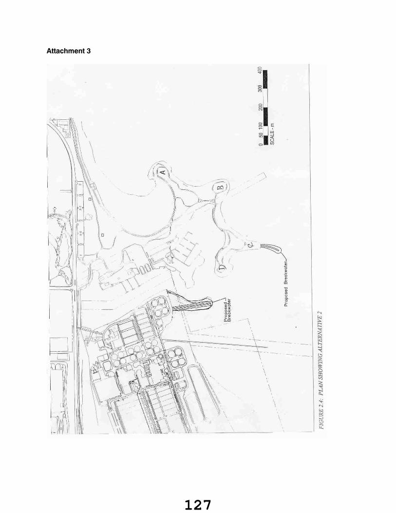
Attachment 3
127
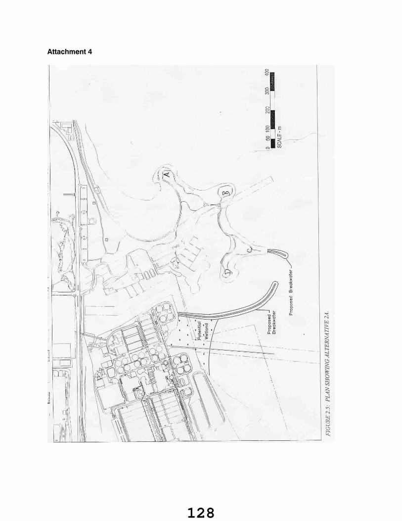
Attachment 4
128
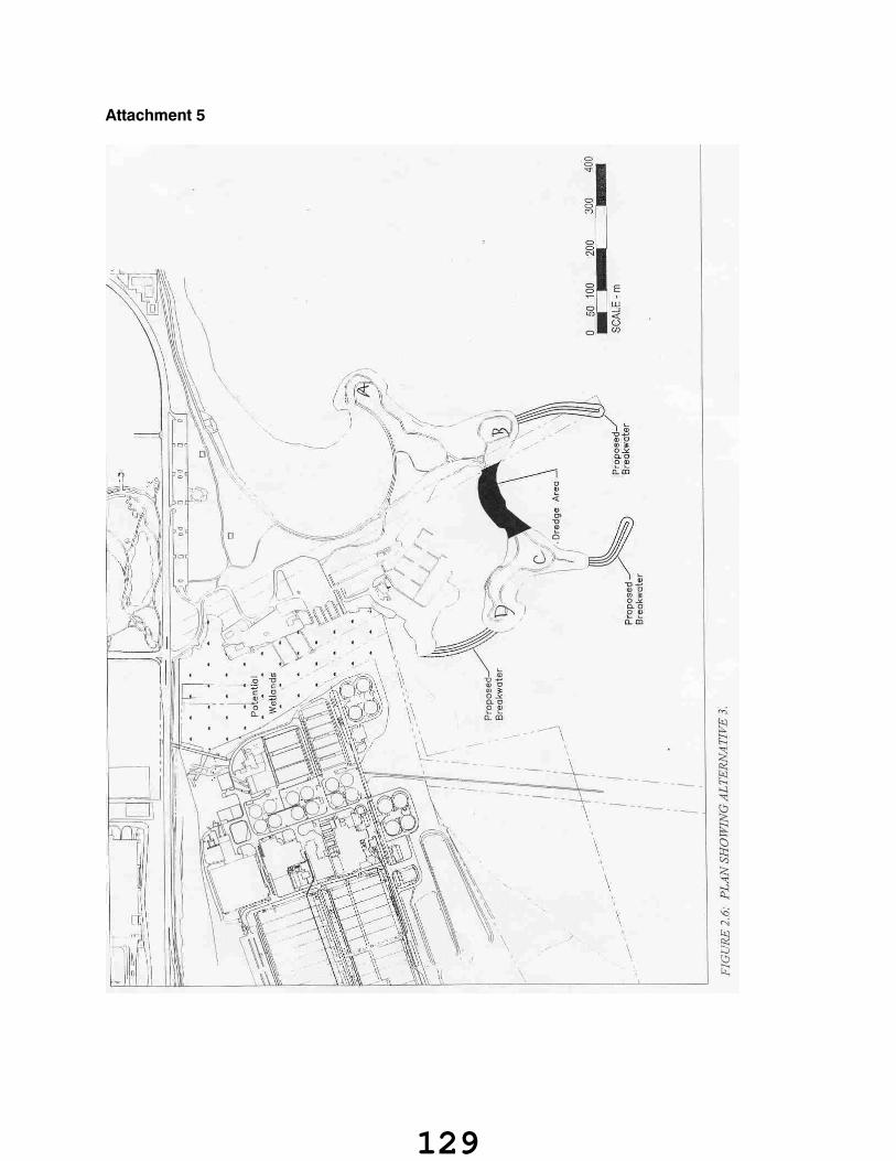
Attachment 5
129
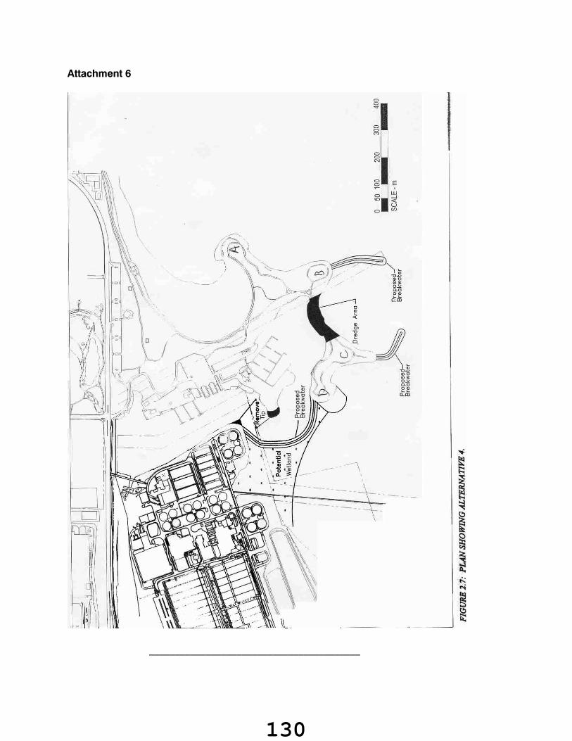
Attachment 6
_________________________________________
130

TERMINATION
ON MOTION, the meeting terminated at 9:31 a.m., on Friday, April 25, 2003.
Dick O'BrienChair
/ks
J. Craig MatherSecretary-Treasurer
131