mean high water manual - government of new jersey
TRANSCRIPT

State of New Jersey
Department of Transportation
Mean High Water Manual
Prepared by Technical Survey Unit
2008
H88
H29
NGVD 29
NAVD 88
HMLLW MHHW
MHW
MTL
MLW
MLLW
Physical location of tidal datum
B
A

Mean High Water Manual 2
Table of Contents Table of Contents ...................................................................................... 2
List of Figures and Tables ......................................................................... 4
Chapter 1: Preface and Introduction ........................................................ 5
Chapter 1: Preface and Introduction ........................................................ 5
1.1 Preface ...................................................................................................... 5
1.2 Introduction .............................................................................................. 5
Chapter 2: Glossary ................................................................................. 7
2.1 Glossary of Tide and Current Terms .......................................................... 7
2.1 Glossary Riparian Right Terms ................................................................ 12
Chapter 3: Tides and Water Levels ......................................................... 19
3.1 Introduction ............................................................................................ 19
3.2 Tide Phenomenon.................................................................................... 19
3.3 Local Height and Arrival Time Factors ..................................................... 20
3.4 Tide Prediction ........................................................................................ 21
3.5 Type of Tides ........................................................................................... 21
3.6 National Tidal Epoch................................................................................ 27
3.7 Changes in Water Level ........................................................................... 28
Chapter 4: Vertical (Elevation) Datums .................................................. 29
4.1 Introduction ............................................................................................ 29
4.2 Local Vertical Datums ............................................................................. 29
4.3 NGVD 29 .................................................................................................. 29
4.4 NAVD 88 .................................................................................................. 30
4.5 Vertical Datums at NJDOT ....................................................................... 30
Chapter 5: Tidal Waters in New Jersey................................................... 33
5.1 Introduction ............................................................................................ 33
5.2 Legal Aspects .......................................................................................... 33
5.3 Mean High Water Information in New Jersey .......................................... 34
Chapter 6: Data Sources and Equipment ................................................ 36
6.1 Introduction ............................................................................................ 36
6.2 Tidal Control Stations and Tidal Benchmarks .......................................... 36
6.3 Tidal Benchmarks .................................................................................... 36
6.4 Determining Tide Elevations at a Control Point From NOS Data Sheets ... 40
6.5 Other Data Sources ................................................................................. 41
6.6 Tidal Predictions ..................................................................................... 41
6.6 Equipment for Tidal Study ....................................................................... 42
Chapter 7: Methods for Mean High Water Studies .................................. 45
7.1 Introduction ............................................................................................ 45
7.2 Graphical or Approximate Method ........................................................... 45

Mean High Water Manual 3
7.3 Control/Observation Based Methods for Mean High Water Study ............ 46
Chapter 8: Height Difference Method: Field Procedures and Data
Reductions .......................................................................... 51
8.1 Introduction ............................................................................................ 51
8.2 Data Collection ........................................................................................ 51
8.4 Determine Staff Conversion Factor (SCF): ............................................... 53
8.5 Forms for the Height Difference Method ................................................. 54
Chapter 9: Range Ratio Method: Field Procedures and Data Reductions 58
9.1 Introduction ............................................................................................ 58
9.2 Data Collection ........................................................................................ 58
9.3 Determine Staff Conversion Factor (SCF) ................................................ 59
9.4 Forms for the Range Ratio Method .......................................................... 61
Chapter 10: Amplitude Ratio Method: Field Procedures and Data
Reductions .......................................................................... 68
10.1 Introduction .......................................................................................... 68
10.2 Data Collection ...................................................................................... 68
10.3 Determine Staff Conversion Factor (SCF): ............................................. 70
10.4 Forms for the Amplitude Ratio Method .................................................. 71
Chapter 11: Riparian Rights in New Jersey ............................................. 79
11.1 Note and Introduction ........................................................................... 79
11.2 Fund for The Support of Public Schools ................................................. 80
11.3 Public Trust Doctrine ............................................................................. 83
11.4. Ecological Considerations ...................................................................... 88
11.5 Riparian and Other Related Statutes ..................................................... 91
11.6 Riparian Cases ...................................................................................... 95
11.7 Title Studies and Surveys ...................................................................... 99
11.8 Appraisals ........................................................................................... 101
Bibliography and References ................................................................ 103
Appendix I: Tidal Stations in New Jersey .............................................. 104
Appendix II: Computation Forms for the Height Difference Method ...... 114
Appendix III: Computation Forms for the Range Ratio Method............. 115
Appendix III: Computation Forms for the Range Ratio Method............. 116
Appendix IV: Computation Forms for the Amplitude Ratio Method ....... 117
Appendix IV: Computation Forms for the Amplitude Ratio Method ....... 118
Appendix IV: Computation Forms for the Amplitude Ratio Method ....... 119

Mean High Water Manual 4
List of Figures and Tables
Figure 3.1 Water level height variations (ft.) associated with tides. The zero datum in this
figure is the Mean Sea Level. ............................................................................ 20
Figure 3.2 Semidiurnal, Mixed and Diurnal tides ....................................................... 22
Figure 3.3 Variation in tide heights during a lunar cycle ............................................. 23
Figure 3.4 Spring and Neap tides ............................................................................ 24
Figure 3.5 Tidal and geodetic datums ...................................................................... 25
Figure 3.6 The M 54 RESET tidal benchmark in point pleasant NJ ................................ 26
Figure 3.7 The rise of the Mean Sea Level at Sandy Hook, NJ between 1935-2000 ........ 28
Figure 4.1 Elevation differences between NGVD 29 and NAVD 88 ................................ 32
Figure 6.1 Parts 1 and 2 of a tidal station data sheet ................................................. 37
Figure 6.2 Part 3 of a tidal station data sheet ........................................................... 39
Table 6.1 Elevations of tidal benchmarks in NGVD 29 and NAVD 88 ............................ 40
Table 6.2 Tidal datum at Alpine tidal station in NAVD 88 ............................................ 40
Figure 6.3 Water level at Port Newark, NJ as computed at www.tides.com ................... 42
Figure 7.1 A plot of water level observation as a function of time (Minutes) ................. 49
Figure 8.1 The geometric relationship between a tide staff and a tidal benchmark ........ 52
Figure 8.2 An example of computing the SCF for a tidal control station ........................ 54
Figure 8.3 The header of page 1 of the height difference form .................................... 55
Figure 8.4 Information recorded for a control station ................................................. 55
Figure 8.5 Information recorded for a subordinate station .......................................... 56
Figure 8.6 Observation and computation table for a height difference study ................. 57
Figure 9.1 The header of page 1 of the range ratio form ............................................ 61
Figure 9.2 Information recorded for a control station ................................................. 62
Figure 9.3. Information recorded for a subordinate station .......................................... 63
Figure 9.4 The first section of page 2 of the range ratio form ..................................... 64
Figure 9.5 Computing MHW using the range ratio method .......................................... 64
Figure 9.6 Section three of page 2 of the range ratio form ......................................... 65
Figure 9.7 The header section of page 3 of the range ration form ............................... 66
Figure 9.8 Observation recording sheet for control station ......................................... 67
Figure 9.9 Observation recording sheet for control station ......................................... 67
Figure 10.1 The header of page 1 of the amplitude ratio form .................................... 72
Figure 10.2 Information recorded for a control station ............................................... 72
Figure 10.3 Information recorded for a subordinate station ........................................ 73
Figure 10.4 The first section of page 2 of the range ratio form.................................... 74
Figure 10.5 Computing MHW using the amplitude ratio method .................................. 74
Figure 10.6 Section three of page 2 of the range ratio form ....................................... 75
Figure 10.7 The header section of page 3 of the range ratio form ............................... 76
Figure 10.8 Observation recording sheet for control station ........................................ 76
Figure 10.9 Plotting the high tide curve. ................................................................... 77
Figure 10.10 Data summary for a control station. ..................................................... 78

Mean High Water Manual 5
Chapter 1: Preface and Introduction
1.1 Preface
1.1.1 Purpose
The purpose of this manual is to establish a uniform method for determining water level
as applied to safety, construction projects, and bridge clearance determination in tidal areas. It is to be used in conjunction with the Survey Manual.
1.1.2 Preparation and Revisions
This manual was developed through the cooperation and effort of numerous staff members and the surveying program of the New Jersey Institute of Technology. Updating
the manual will be a continuous process and revisions will be issued periodically. Some of the revisions will become necessary as a result of changes in specifications and
methodology, while others result from user feedback. All manual users are encouraged to suggest modifications and improvements to this manual to the Regional Design and Survey Services New Jersey Department of Transportation, PO Box 600, Trenton, New
Jersey 08625.
1.2 Introduction
Determination of bridge clearance and the proper design of cofferdams, caissons, and bridge fenders over navigable rivers and other waterways are important safety and transportation network management issues. An error in calculating or determining the
correct bridge clearance and in determining the proper elevations of cofferdams, caissons, etc. could result in safety hazard conditions, property damage or damage to the integrity
of the transportation network. A minimum bridge clearance is calculated from tide observations, tide predictions, the expected life span of the structure and from an assessment of the size of vessels expected to travel beneath them.
Water levels and clearances are expressed in terms of elevations in a particular height system. There are a number of different height systems that are routinely used by
surveyors and engineers in New Jersey. Therefore, to avoid implementation errors, it is essential that proper methods and procedures are exercised during the surveying, the engineering design, and the construction stakeout phases, to ensure that a consistent
height system is being used.
The tidal water level is a dynamic phenomenon that changes constantly. Some of the
recent observations indicate that water levels of the oceans are slowly increasing due to global warming and other changes in global weather patterns. In addition, ship sizes are
increasing as well. These changes may require a reassessment of designated clearances of some bridges, in particular waterways, and an update of current clearance values that have been computed many years ago.
Employing inappropriate procedures and using very old data that has not been properly documented and field verified could result in problems during construction.
Implementation mistakes lead to problems in the operation of waterways. In some cases it may lead to a more restrictive usage of the waterway than initially intended. It could also create problems with regulatory agencies and it may impact on the rights of the
public and adjacent owners. Not using the waterway to its fullest intent may, in turn, have a negative impact on the local economy.
Presently, Engineers establish water levels using self established in-house methods and practices. These methods do not produce sufficiently the necessary accurate water levels that are required for NJDOT projects. Therefore, it has been decided to establish

Mean High Water Manual 6
recommended methods and procedures for the establishment of water levels. The methods and procedures will provide guidance to its consultants and in house staff on how
to determine accurately the water levels that are required for construction projects, Tidelands and US Coast Guard permitting processes, bridge clearance determination and
other applications. Therefore, it has been decided to establish policies on the minimum standards that are required to meet the needs of current and regulatory water levels, and to predict the various water levels needs of different construction and non-construction
projects.
There are a number of data sources and several analytical methods for determining water
levels. Depending on the site configuration, on regulatory requirements, on data sources and on analyses sought, different methods should be utilized. In some cases several alternative approaches should be investigated for a particular site. This manual addresses
the technical aspects of water level determination, not policy or regulatory issues.
The objective of this manual is to establish a uniform procedure for determining water
level as applied to safety, construction projects and bridge clearance determination in tidal areas. Chapter 1 is an introduction to the manual and to the issues regarding activities in areas subject to tides. Chapter 2 provides a Glossary of terms used. Chapter 3 provides a
brief discussion on the phenomena of tides. Chapter 4 discusses the various vertical and tidal datums used to establish benchmark elevations. The discussion of datums includes
the physical aspects of datums and the mathematical relationships between these datums. Chapter 5 provides information on legal aspects of mean high water (MHW) and its
relevance to activities. Data sources such as tidal control station locations, different water levels (e.g. high, low, mean etc.) at these tidal control stations, tidal benchmark elevations and tide predictions are discussed in chapter 6. A brief description of typical
equipment used to conduct water level studies is given in chapter 6 as well. Chapter 7 provides a general explanation of methods for determining the MHW at a project site. It
includes approximate methods for determining the MHW and methods based actual field observations. The three recommended MHW study methods, the height difference method, the range ration method and the amplitude ratio method are then described in
detail in chapters 8, 9 and 10, respectively.
The manual also includes a list of tidal control stations in New Jersey with hyperlinks to
the National Ocean Service (NOS) and the National Geodetic Survey (NGS) databases. The New Jersey Department of Environmental Protection (NJDEP), Bureau of Water Resources, is the agency that has the responsibility to maintain the tidal control stations
and the associated data. The Tidelands Unit of NJDEP maintains the official data for the tidal control stations and for official use must be acquired from NJDEP. For unofficial use,
the NJDOT Geodetic Survey Section has copies of most the tidal control stations. The list of tidal control stations can be used to locate and gain quick access to the latest available information for these stations. The manual also includes three sets of computation forms
for computing and recording MHW studies using the three outlined methods. The appropriate set of forms shall be submitted to DOT following the completion of a MHW
study. An extensive glossary of terms related to tides is furnished as well as an appendix to the manual. Lastly, the manual includes selected sections from the riparian handbook of NJDOT staff and outside consultants that work in tidal waters are required to be familiar
with the status and regulations concerning riparian rights.

Mean High Water Manual 7
Chapter 2: Glossary
2.1 Glossary of Tide and Current Terms
Automatic Tide Gage
An instrument that automatically registers the rise and fall of the tide. In some
instruments, the registration is accomplished by recording the heights at regular time intervals in digital format; in others, by a continuous graph of height against time. The
automatic gages used by the National Ocean Service are of both types.
Benchmark (BM)
A fixed physical object or mark used as reference for a vertical datum. A tidal benchmark
is one near a tide station to which the tide staff and tidal datums are referred. A primary benchmark is the principal (or only) mark of a group of tidal benchmarks to which the tide
staff and tidal datums are referred. The standard tidal benchmark of the National Ocean Service is a brass, bronze, or aluminum alloy disk 3-1/2 inches in diameter containing the inscription NATIONAL OCEAN SERVICE together with other individual identifying
information.
Coast line
The low water datum line for purposes of the Submerged Lands Act (Public Law 31). See shoreline.
Coastal boundary
The mean high water line (MHWL) or mean higher high water line (MHHWL) when tidal lines are used as the coastal boundary. Also, lines used as boundaries inland of and
measured from (or points thereon) the MHWL or MHHWL. See marine boundary.
Datum (vertical)
For marine applications, a base elevation used as a reference from which to reckon
heights or depths. It is called a tidal datum when defined in terms of a certain phase of the tide. Tidal datums are local datums and should not be extended into areas which have
differing hydrographic characteristics without substantiating measurements. In order that they may be recovered when needed, such datums are referenced to fixed points known as benchmarks.
Epoch
As used in tidal datum determination, it is 19-year cycle over which tidal height
observations are meaned in order to establish the various datums. As there are periodic and apparent secular trends in sea level, a specific 19-year cycle (the National Tidal
Datum Epoch NTDE) is selected so that all tidal datum determinations throughout the United States will have a common reference.
High tide
Same as high water.
High water (HW)
The maximum height reached by a rising tide. The high water is due to the periodic tidal forces and the effects of meteorological, hydrologic, and/or oceanographic conditions. For tidal datum computational purposes, the maximum height is not considered a high water
unless it contains a tidal high water.
High water line
Mean High Water Manual 8
The intersection of the land with the water surface at an elevation of high water.
High water mark
A line or mark left upon tide flats, beach, or along shore objects indicating the elevation of the intrusion of high water. The mark may be a line of oil or scum on along shore objects,
or a more or less continuous deposit of fine shell or debris on the fore shore or berm. This mark is physical evidence of the general height reached by wave run up at recent high waters. It should not be confused with the mean high water line or mean higher high
water line.
Higher high water (HHW)
The highest of the high waters (or single high water) of any specified tidal day due to the declination Al effects of the Moon and Sun.
Higher low water (HLW)
The highest of the low waters of any specified tidal day due to the declination Al effects of the Moon and Sun.
Low water (LW)
The minimum height reached by a falling tide. The low water is due to the periodic tidal forces and the effects of meteorological, hydrologic, and/or oceanographic conditions. For
tidal datum computational purposes, the minimum height is not considered a low water unless it contains a tidal low water.
Low water datum (LWD)
An approximation of mean low water that has been adopted as a standard reference for a
limited area and is retained for an indefinite period regardless of the fact that it may differ slightly from a better determination of mean low water from a subsequent series of observations. Used primarily for river and harbor engineering purposes.
Lower low water datum (LLWD)
An approximation of mean lower low water that has been adopted as a standard reference
for a limited area and is retained for an indefinite period regardless of the fact that it may differ slightly from a better determination of mean lower low water from a subsequent series of observations. Used primarily for river and harbor engineering purposes.
Mean high water (MHW)
A tidal datum. The average of all the high water heights observed over the National Tidal
Datum Epoch. For stations with shorter series, simultaneous observational comparisons are made with a control tide station in order to derive the equivalent datum of the National Tidal Datum Epoch.
Mean high water line (MHWL)
The line on a chart or map which represents the intersection of the land with the water
surface at the elevation of mean high water. See shoreline.
Mean higher high water (MHHW)
A tidal datum. The average of the higher high water height of each tidal day observed
over the National Tidal Datum Epoch. For stations with shorter series, simultaneous observational comparisons are made with a control tide station in order to derive the
equivalent datum of the National Tidal Datum Epoch.
Mean higher high water line (MHHWL)

Mean High Water Manual 9
The line on a chart or map which represents the intersection of the land with the water surface at the elevation of mean higher high water.
Mean low water (MLW)
A tidal datum. The average of all the low water heights observed over the National Tidal
Datum Epoch. For stations with shorter series, simultaneous observational comparisons are made with a control tide station in order to derive the equivalent datum of the National Tidal Datum Epoch.
Mean low water line (MLWL)
The line on a chart or map which represents the intersection of the land with the water
surface at the elevation of mean low water.
Mean low water springs (MLWS)
A tidal datum. Frequently abbreviated spring low water. The arithmetic mean of the low
water heights occurring at the time of spring tides observed over the National Tidal Datum Epoch. It is usually derived by taking an elevation depressed below the half-tide level by
an amount equal to one-half the spring range of tide, necessary corrections being applied to reduce the result to a mean value. This datum is used, to a considerable extent, for hydrographic work outside of the United States and is the level of reference for the Pacific
approaches to the Panama Canal.
Mean lower low water (MLLW)
A tidal datum. The average of the lower low water height of each tidal day observed over the National Tidal Datum Epoch. For stations with shorter series, simultaneous
observational comparisons are made with a control tide station in order to derive the equivalent datum of the National Tidal Datum Epoch.
Mean lower low water line (MLLWL)
The line on a chart or map which represents the intersection of the land with the water surface at the elevation of mean lower low water.
Mean range of tide (Mn)
The difference in height between mean high water and mean low water.
Mean rise
The height of mean high water above the elevation of chart datum.
Mean sea level (MSL)
A tidal datum. The arithmetic mean of hourly heights observed over the National Tidal Datum Epoch. Shorter series are specified in the name; e.g., monthly mean sea level and yearly mean sea level.
Mean tide level (MTL)
Same as half-tide level.
Mean water level (MWL)
A datum. The mean surface elevation as determined by averaging the heights of the water at equal intervals of time, usually hourly. Mean water level is used in areas of little or no
range in tide.
Mean water level line (MWLL)

Mean High Water Manual 10
The line on a chart or map which represents the intersection of the land with the water surface at the elevation of mean water level.
National Geodetic Vertical Datum of 1929 [NGVD (1929)]
A fixed reference adopted as a standard geodetic datum for elevations determined by
leveling. The geodetic datum that was formerly in use in the United States is the National Geodetic Vertical Datum 1929. The year indicates the time of the general adjustment. It is also a synonym for Sea-level Datum of 1929. The geodetic datum is fixed and does not
take into account the changing stands of sea level. Because there are many variables affecting sea level, and because the geodetic datum represents a best fit over a broad
area, the relationship between the geodetic datum and local mean sea level is not consistent from one location to another in either time or space. For this reason, the National Geodetic Vertical Datum should not be confused with mean sea level.
National Tidal Datum Convention of 1980
Effective November 28, 1980, the Convention: (1) establishes one uniform, continuous
tidal datum system for all marine waters of the United States for the first time in its history; (2) provides a tidal datum system independent of computations based on type of tide; (3) lowers chart datum from mean low water to mean lower low water along the
Atlantic coast of the United States; (4) updates the National Tidal Datum Epoch from 1941 through 1959, to 1960 through 1978.
National Tidal Datum Epoch (NTDE)
The specific l9-year period adopted by the National Ocean Service as the official time
segment over which tide observations are taken and reduced to obtain mean values (e.g., mean lower low water, etc.) for tidal datums. It is necessary for standardization because of periodic and apparent secular trends in sea level. The present National Tidal Datum
Epoch is 1960 through 1978. It is reviewed annually for possible revision and must be actively considered for revision every 25 years.
North American Vertical Datum of 1988 (NAVD 88)
A fixed reference for elevations determined by goedetic leveling. The datum was derived from a general adjustment of the first-order terrestrial leveling nets of the United States,
Canada, and Mexico. This is the current vertical datum.
Primary control tide station
A tide station at which continuous observations have been made over a minimum of 19 years. Its purpose is to provide data for computing accepted values of the harmonic and non harmonic constants essential to tide predictions and to the determination of tidal
datums for charting and for coastal and marine boundaries. The data series from this station serves as a primary control for the reduction of relatively short series from
subordinate tide stations through the method of comparison of simultaneous observations and for monitoring long-period sea level trends and variations.
Range of tide
The difference in height between consecutive high and low waters. The mean range is the difference in height between mean high water and mean low water. The great diurnal
range or diurnal range is the difference in height between mean higher high water and mean lower low water.
Secondary control tide station
Mean High Water Manual 11
A tide station at which continuous observations have been made over a minimum period of 1 year but less than 19 years. The series is reduced by comparison with simultaneous
observations from a primary control tide station. This station provides for a 365-day harmonic analysis including the seasonal fluctuation of sea level.
Spring high water
Same as mean high water springs (MHWS). See spring tides.
Spring low water
Same as mean low water springs (MLWS). See spring tides and mean low water springs.
Spring tides or tidal currents
Tides of increased range or tidal currents of increased speed occurring semimonthly as the result of the Moon being new or full. The spring range (Sg) of tide is the average range occurring at the time of spring tides and is most conveniently computed from the
harmonic constants. It is larger than the mean range where the type of tide is either semi diurnal or mixed, and is of no practical significance where the type of tide is
predominantly diurnal. The average height of the high waters of the spring tides is called spring high water or mean high water springs (MHWS) and the average height of the corresponding low waters is called spring low water or mean low water springs (MLWS).
Subordinate tide station
A tide station from which a relatively short series of observations is reduced by
comparison with simultaneous observations from a tide station with a relatively long series of observations. See tide station, primary control tide station, secondary control
tide station, and tertiary tide station. (2) A station listed in the Tide Tables from which predictions are to be obtained by means of differences and ratios applied to the full predictions at a reference station.
Tertiary tide station
A tide station at which continuous observations have been made over a minimum period
of 30 days but less than 1 year. The series is reduced by comparison with simultaneous observations from a secondary control tide station. This station provides for a 29-day harmonic analysis.
Tidal benchmark description
A published, concise description of the location, stamped number or designation, date
established, and elevation (referred to a tidal datum) of a specific bench mark.
Tide (water level) gage
An instrument for measuring the rise and fall of the tide (water level).
Tide staff
A tide gage consisting of a vertical graduated staff from which the height of the tide can
be read directly. It is called a fixed staff when secured in place so that it cannot be easily removed. A portable staff is one that is designed for removal from the water when not in use. For such a staff a fixed support is provided The support has a metal stop secured to it
so that the staff will always have the same elevation when installed for use.
Tide (water level) station
The geographic location at which tidal observations are conducted. Also, the facilities used to make tidal observations. These may include a tide house, tide gage, tide staff, and tidal

Mean High Water Manual 12
bench marks. See primary control tide station, secondary control tide station, tertiary tide station, and subordinate tide station.
2.1 Glossary Riparian Right Terms
Several words and terms commonly used in the discussion of riparian rights are not
normally encountered in general usage. Many are real estate or legal, especially water law, terms. A number of the frequently used terms are defined in this section. The definitions were derived from a number of sources including: Black's Law Dictionary,
Corpus Juris Secundum, Webster's International Dictionary, and New Jersey case law.
Accretion
The process of gradual and imperceptible addition of solid material, called alluvion, thus extending the shore line out by deposits made by contiguous water.
Alluvion
That increase of earth on a shore or bank of a stream or sea, by the force of the water, as by a current or by waves, which is so gradual that it is impossible to determine how much
is added at each moment of time.
Appraisal
An estimate and opinion of value. It usually consists of a written statement of (a) the
market value or value for loan purposes, or value as defined by the appraiser, of (b) an adequately described parcel of property as of (c) a specified date. It is a conclusion which
results from the analysis of facts.
Avulsion
A sudden and perceptible loss or addition to land by the action of water or otherwise.
Base Map
A map having sufficient points of reference, such as state, county, or township lines and
other selected physical features, to allow the plotting of other data.
Brook
Synonym of "creek", a small stream less than a river.
Bulkhead
A retaining wall created along the water behind which solid fill is placed, thus extending
the upland out to the bulkhead line.
Bulkhead Line
A line along navigable water beyond, that is, offshore of, which no solid fill is permitted.
CAFRA
The Coastal Area Facility Review Act, N.J.S A. 13:19-1 et seq., provides for State planning
and regulation of siting of major facilities in the statutorily defined coastal area.
Consideration
The inducement to a contract. The cause, motive, price, or impelling influence which induces a contracting party to enter into a contract. The reason or material cause of a contract. In real estate practice, usually the actual price at which property is transferred.
Current

Mean High Water Manual 13
The part of any body of water that has a more or less steady flow in a definite direction.
Datum
A reference point, line or plane used as a basis of measurements.
Datum Plane
A surface used as a reference from which heights or depths are reckoned.
Department of Environmental Protection
The Department of Environmental Protection, or DEP, was established by N.J.S.A.13:1 D-
1 et seq., and directed to formulate comprehensive policies for the conservation of the State's natural resources, the promotion of environmental protection and the prevention
of pollution. It succeeded to the lands and resource management functions that had been formerly assigned to the Department of Conservation and Economic Development, and the pollution control functions of the Department of Health.
Erosion
The wearing away of the land-surface by running water, wind, or other geological agents.
Estuary
That part of the mouth or lower course of a river flowing into the sea, which is subject to tide; especially an enlargement of a river channel towards its mouth in which the
movement of the tide is very prominent.
Fair Market Value
Price which, in all probability, would voluntarily be agreed upon in fair negotiations between an owner willing, but not forced, to sell and a buyer willing, but not forced, to
buy. It is the price, which is generally said to determine the fair amount of compensation to be paid to the owner.
Fee Simple: Fee Simple Absolute
An absolute fee, interest in land, the owner of which is entitled to the entire property, with unconditional power of disposition.
Front Foot
A land measure being one foot in width along the frontage of a property.
Grant
An instrument which conveys some estate or interest in the lands which it embraces. A riparian grant conveys an estate, usually a fee simple, in State owned riparian lands.
Hackensack Meadowlands Development Commission
A seven member agency established by statute, N.J.S A. 13:17-1 et seq., with broad land
use and development authority concerning the 21,000 acre Hackensack Meadowlands District.
Laches
Inexcusable delay in asserting a right. The New Jersey case law indicates that the doctrines of laches and estoppel do not apply against the State in the same way as they
do with regard to private parties.

Mean High Water Manual 14
Land Reclamation
Making land capable of more intensive use by changing its character, environment, or
both, through operations such as drainage, provision of water, or otherwise.
Leaching
Removal of material from soil by taking it into solution. This condition is especially prevalent at landfill sites where pollutants may leach into the ground and surface waters.
Lease
An agreement which gives rise to a relationship of landlord and tenant. A lease is spoken of as a hiring of land, or a sale of the possession, occupation and profits of land for a
term.
License
Permission or authority to perform a particular act or series of acts on lands of another
without possessing any estate or interest therein; the privilege to occupy under the owner.
Littoral
Pertaining to the shore, particularly of the seas and oceans.
Littoral Drift
The movement of water along the shoreline which results in the transport of grains of sand. The direction and force of littoral drift is a product of currents and winds.
Marketable Title
A title not subject to such reasonable doubt as would create a just apprehension of
invalidity in the mind of a reasonable, prudent, and intelligent person. Title that a person of reasonable prudence and intelligence, guided by competent legal advice,
would be willing to take and pay fair value for.
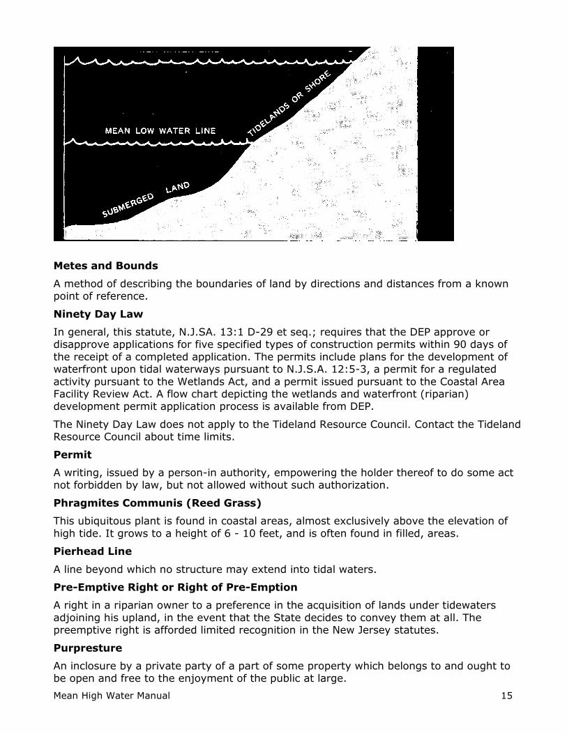
Mean High Water Line or Mark
The line formed by the intersection of the tidal plane of mean high tide with the shore.
The mean, sometimes called ordinary, high tide is defined as the median between the spring and the neap tides. The average to be used should be, if possible, the average of all the high tides over a period of 18.6 years. In New Jersey the State owns all lands, now
or formerly, below the mean high water line, which have not been alienated.
The following diagram depicts the mean high water line.
Mean High Water Manual 15
Metes and Bounds
A method of describing the boundaries of land by directions and distances from a known point of reference.
Ninety Day Law
In general, this statute, N.J.SA. 13:1 D-29 et seq.; requires that the DEP approve or disapprove applications for five specified types of construction permits within 90 days of
the receipt of a completed application. The permits include plans for the development of waterfront upon tidal waterways pursuant to N.J.S.A. 12:5-3, a permit for a regulated
activity pursuant to the Wetlands Act, and a permit issued pursuant to the Coastal Area Facility Review Act. A flow chart depicting the wetlands and waterfront (riparian) development permit application process is available from DEP.
The Ninety Day Law does not apply to the Tideland Resource Council. Contact the Tideland Resource Council about time limits.
Permit
A writing, issued by a person-in authority, empowering the holder thereof to do some act not forbidden by law, but not allowed without such authorization.
Phragmites Communis (Reed Grass)
This ubiquitous plant is found in coastal areas, almost exclusively above the elevation of
high tide. It grows to a height of 6 - 10 feet, and is often found in filled, areas.
Pierhead Line
A line beyond which no structure may extend into tidal waters.
Pre-Emptive Right or Right of Pre-Emption
A right in a riparian owner to a preference in the acquisition of lands under tidewaters
adjoining his upland, in the event that the State decides to convey them at all. The preemptive right is afforded limited recognition in the New Jersey statutes.
Purpresture
An inclosure by a private party of a part of some property which belongs to and ought to be open and free to the enjoyment of the public at large.

Mean High Water Manual 16
Quitclaim Deed
A deed of conveyance operating by way of release; that is, intended to pass any title,
interest or claim which the grantor may have in the premises, but not professing that such title is valid, and not containing any warrant or covenant for title.
Reliction
The gradual withdrawal of the water from the land by the lowering of its surface level from any cause. Used interchangeably with the term dereliction.
Return
The line between the mean high water line and the seaward extension of a permitted
structure, such as a bulkhead.
Rip Rap
A foundation of stones or rocks loosely placed together without order in deep water to
prevent scour on the sides of bulkheads and similar construction.
Ripa
Land bordering on the mean high water line; upland, if it extends to and has contact with tidewater.
Riparian Grant
The grant of the lands below the mean high water line; initiating at the mainland and limited in outward extent by exterior lines.
Riparian Proprietor
An owner of land, bounded generally upon a stream of water. Used frequently to indicate
the owner of the land adjoining the shore of tide waters above the ordinary flow of the tide.
Riparian Rights
The rights of the owners of lands on the banks of watercourses, relating to the water, its use, and ownership of soil under the stream. For the purposes of this handbook, the term
is used to describe only those rights of landowners abutting on tide-flowed lands.
River
A natural stream of water, of greater volume than a creek or riverlet, flowing in a more or
less permanent bed or channel, between defined banks or walls, with a current which may either be continuous in one direction or affected by the ebb and flow of the tide.
Royalty
In real estate usage, it is the money paid to an owner of realty for the right of depleting the property of its natural resource, such as oil, gas, minerals, stone, builders' sand and
gravel, and timber.
School Fund
Fund for the support of free public schools. See Chapter 11.2.
Soil Map
A map designed to portray the distribution and location of soil types, phases, and
complexes as well as other selected cultural and physical features.
Mean High Water Manual 17
Spartina Alteriflora; Saltmarsh Cord Grass
A common saltmarsh grass, rich in nutrients, whose roots are washed by the tides twice
daily. It grows to a maximum height of four (4) feet.
Spartina Pans; Salt Hay; Cord Grass
A common saltmarsh grass found on slightly higher ground than spartina alterniflora. It grows to a maximum height of one foot and is washed by higher than average tides.
State Owned Riparian Lands
Those lands now or formerly flowed by the mean high water line and owned by the State of New Jersey.
Stream
A watercourse having a source and terminus, banks and channel through which waters flow at least periodically. It usually empties into lakes, other streams or the ocean, but it
does not lose its character as a watercourse even though it may break up and disappear.
Submerged Lands
Those lands situated below the mean low water line. Sometimes used to describe all of the lands covered by the mean high water line.
Survey
The process of scientifically ascertaining the quantity and/or location of a piece of land; it may include physical features affecting it, such as grades, contours, and structures. A
statement of the courses, distances and quantity of land.
Tide
The periodic rise and fall of the surface waters of the oceans and of the waters connected with them, caused by the gravitational pull of the moon and sun. In each lunar day of 24 hours and 51 minutes there are two high tides and two low tides.
Tidelands
Those lands situated between the mean high water line and the mean low water line.
Usufructuary.
One who has the right of enjoying a thing, the property of which is vested in another, and to draw from the same all the property, utility and advantage, which it may produce,
provided it be without altering the substance of the thing.
Waterway
A synonym of watercourse. A watercourse is a channel or canal for the conveyance of water, which may be natural or artificial in its formation. The watercourse usually flows in a particular direction though it need not flow continuously. Since it flows in a channel, it
must have a bed or banks, and must be more than a mere surface drainage over the entire face of the tract of land.
Wetlands
The Wetlands Act of 1970, N.J.S A. 13:9A-1 et seq., authorizes the DEP to regulate the use of coastal wetlands. These consist of low lands subject to tidal action whose surface is
at or below an elevation of 1 foot above local extreme high water and which are capable of supporting certain listed types of vegetation. It should be noted that the statute

Mean High Water Manual 18
expressly exempts the area within the jurisdiction of the Hackensack Meadowlands Development Commission.

Mean High Water Manual 19
Chapter 3: Tides and Water Levels
3.1 Introduction
Knowledge of the times, heights, and extent of inflow and outflow of tidal waters is of importance in a wide range of practical applications. Transportation applications of tides
include: navigation through intra-coastal waterways, and within estuaries, bays, and harbors; work on harbor engineering projects, such as the construction of bridges, docks,
breakwaters, and deep-water channels.
This chapter discusses the tide phenomenon and its associated terminology. The discussion includes an overview on the cause of tides and on the factors that influence the
shape and magnitude of tides in particular locations at particular times. Tidal datum, the national tidal epoch and the rise of water levels as a result of global warming are
discussed as well.
3.2 Tide Phenomenon
The word "tide" is a generic term used to define the alternating rise and fall in sea level
with respect to the land. The main factor that instigates tides is the gravitational attraction of the moon and the sun. Additional non-astronomical factors such as
configuration of the coastline, local depth of the water, ocean-floor topography, and other hydrographic and meteorological influences may also play an important role in altering the range (span between high and low water) and times of arrival of the tides. Extraordinary
high tides could be caused by extreme weather conditions such as "Northeasters" or hurricanes resulting in wind-actuated high waves and swells.
As stated previously, ordinary tides are caused primarily by the gravitational attraction between the masses of the Moon and the Sun and the mass of ocean waters following Newton's law of gravitation. High tides are produced in the ocean waters by the "heaping"
action resulting from the horizontal flow of water toward two regions of the earth representing positions of maximum attraction of combined lunar and solar gravitational
forces. Low tides are created by a compensating maximum withdrawal of water from regions around the earth midway between these two humps. The alternation of high and low tides is caused by the daily (or diurnal) rotation of the earth with respect to these two
tidal humps and two tidal depressions. The changing arrival time of any two successive high or low tides at any one location is the result of numerous factors such as the
dynamics of earth-sun-moon motions. An illustration of different water levels associated with tides is presented in Figure 3.1.

Mean High Water Manual 20
Figure 3.1 Water level height variations (ft.) associated with tides. The zero datum in this figure is the Mean Sea Level.
3.3 Local Height and Arrival Time Factors
The first factor of consequence in producing tides arises from the fact that the crests and troughs of the large-scale gravity-type traveling wave system striving to sweep continuously around the earth, following the position of the moon (and sun). In the open
ocean, the actual rise of the tidally induced wave crest is only one to a few feet. It is only when the tidal crests and troughs move into shallow water, against land masses, and into
confining channels, that noticeable variations in the height of sea level can be detected.
Possessing the physical properties of a fluid, the ocean waters follow all of the hydraulic laws of fluids. This means that since the ocean waters possess a definite, although small
internal viscosity, this property prevents absolute free flow of the tidal wave and somewhat retards the overall movement of the tides.
Secondly, the ocean waters follow the principle of traveling waves in a fluid. As the depth of the water shallows, the speed of forward movement of a traveling wave is retarded, as deducted from dynamic considerations. In shoaling situations, therefore, the advance of
tidal waters is slowed.
Thirdly, a certain relatively small amount of friction exists between the water and the
ocean floor over which it moves - again slightly slowing the movement of the tides, particularly as they move inshore. Further internal friction (or viscosity) exists between
tidally induced currents and contiguous currents in the oceans - especially where they are flowing in opposite directions.
The presence of landmasses imposes a barrier to the progress of the tidal waters. Where
continents interpose, tidal movements are confined to separate, nearly closed oceanic basins and the sweeps of the tides around the world is not continuous.
Topography on the ocean floor can also provide a restraint to the forward movement of tidal waters - or create sources of local-basin response to the tides. Restrictions to the advance of tidal waters imposed both by shoaling depths and the sidewalls of the channel
as these waters enter confined bays, estuaries, and harbors can further considerably alter the speed of their onshore passage.

Mean High Water Manual 21
All of the above, and other less important influences, can combine to create a considerable variety in the observed range and phase sequence of the tides - as well as
variations in the times of their arrival at any location.
Of a more local and sporadic nature, important meteorological contributions to the tides
know as "storm surges", caused by a continuous strong flow of winds either onshore or offshore, may superimpose their effects upon those of tidal action to cause either heightened or diminished tides, respectively. High-pressure atmospheric systems may
also depress the tides, and deep low-pressure systems may cause them to increase in height.
Further information on the factors influencing the heights and arrival time of tides at a particular location is available at the National Ocean Service web site: http://www.opsd.nos.noaa.gov/restles5.html.
3.4 Tide Prediction
Because tides are produced essentially by astronomical forces of harmonic nature, a
definite relationship exists between the tide-generating forces and the observed tides. This relationship allows a mathematically based formulation of predicted occurrences of high and low tides. In fact, predictions of high and low tides occurrences for specific
locations are available in local newspapers and weather reports. Commercial software and Internet based tide predictions (e.g. co-ops.nos.noaa.gov/tp4days.html or
www.tides.com) are also available.
However, because of the numerous uncertainties and, in some cases, completely unknown
factors of local control mentioned above, it is not feasible to predict tides purely from a knowledge of the positions and movements of the moon and sun obtained from astronomical tables. A partially empirical approach based upon actual observations of
tides in many areas over an extended period of time is necessary. To achieve maximum accuracy in prediction, a series of tidal observations at one location ranging over at least a
full 18.6-year tidal cycle is required. Within this period, all significant astronomical modifications of tides will occur.
For the purpose of computing and tabulating tides, the National Ocean Survey (NOS), a
component of the National Oceanic and Atmospheric Administration (NOAA) of the U.S. Department of Commerce, maintains a continuous control network of approximately 140
tide gages which are located along the coasts and within the major embayments of the United States, and its possessions, and the United Nations Trust Territories under its jurisdiction. Temporary secondary stations are also occupied in order to increase the
effective coverage of the control network. Predictions of the times and heights of high and low water are prepared by the National Ocean Survey for a large number of stations in the
United States and its possessions, as well as foreign countries and the United Nations Trust Territories.
3.5 Type of Tides
It is customary to classify tides according to the number and the shape of the tides curve that occur during a period of approximately 24 hours. In some locations there is a single
high and single low tide per day. In other locations there are two high tides and two low tides per day. Moreover, there are some locations that have more than one high/low tide cycle but not clearly two comparable highs and lows. These different types of tides are
termed as diurnal, semidiurnal and mixed tides respectively as shown in Figure 3.2.
The formal definitions of these tides are:

Mean High Water Manual 22
Diurnal tide - The tide is said to be diurnal when only one high water and one low water occur during a tidal day. For example, tides along the Gulf Coast of Florida generally west
of Apalachicola are of the diurnal type.
Semidiurnal tide - The tide is said to be semidiurnal when two high water and two low
water levels occur during a tidal day. The predominant type of tide throughout the world is semidiurnal. Most of the tides along the east coast of the United States including New Jersey are semidiurnal.
Mixed tide - The tide is said to be mixed when a considerable inequality exists between the higher high and lower high waters and/or higher low and lower low waters that occur
during a tidal day. A mixed tide may be thought of as a transitional tide occurring between areas of semi-diurnal and diurnal tides. Areas where mixed tides occur are, for example, along the Gulf Coast of Florida from the Keys to Apalachicola and along the west
coast of the United Sates.
Figure 3.2 Semidiurnal, Mixed and Diurnal tides

Mean High Water Manual 23
The National Ocean Service (NOS) has established two criteria to determine what constitutes an occurrence of a high or low tide as follows:
One-tenth rule: Adjacent high and low waters must be different in elevation by one-tenth of a foot or more in order to be counted as a tide. If the height difference is less
than 0.10 foot, they are excluded. Two-hour rule: Adjacent high and low waters must be different by two hours or more
in time in order to be counted as a tide. If the time difference is less than two hours,
they are excluded.
In New Jersey there are two high and two low tides in a 24-hour period that constitute semidiurnal tides.
Spring and Neap Tides.
Another classification of tides that New Jersey Department of Transportation consultants and surveyors should be familiar with is spring and neap tides. During the lunar cycle
(29.53 days) the range of tides (the difference between the high and the low tides) varies according to the relative position of the moon and the sun with respect to the earth. The magnitude of the crests and troughs will vary significantly (in the order of a few feet)
during what is commonly referred to as the various phases of the moon. Figure 3.3 illustrates the variation in tide heights at Sandy Hook during the lunar cycle between
March 14 and April 13, 2002. Figure 3.3 shows that while on the 8th day of the lunar cycle the difference between the high and low tides was only about 3 feet, on the 15th day of
the lunar cycle the difference between the high and low tides was about 7 feet.
Tides During a Lunar Cycle
-2
-1
0
1
2
3
4
5
6
7
1 3 5 7 9
11
13
15
17
19
21
23
25
27
29
Day of the Lunar Cycle
Tid
e H
eig
ht
(ft)
High
Low
Figure 3.3 Variation in tide heights during a lunar cycle
When the moon is at a new phase (new moon) and at a full phase (full moon) the sun and
the moon are roughly positioned along an almost straight line. This means that the gravitational attraction of the sun and the moon upon the waters of the earth is at a
maximum since the sun and the moon pull the waters in the same direction. When this happens the observed tidal range is greater at all locations. These greater than average

Mean High Water Manual 24
SUN To Sun
Neap
Tide
First Quarter
Full
Moon
Third Quarter
EARTH New
Moon
Spring
Tide
Neap
Tide
Spring
Tide
tides are known as spring tides. One must realize that the term spring tides merely implies a "welling up" of the water and bears no relationship to the season of the year.
Alternatively, at the first and at the third quarter phases of the moon when it appears to be half full, the gravitational attractions of the moon and sun upon the waters of the earth
are at a right angle to each other. This means that each force tends, in part, to counteract the other. When this happens, the observed tidal range is smaller than average at all locations. High tides are lower and low tides are higher than average because weaker
forces are induced on the average water level. Such tides are called neap tides, from a Greek word meaning "scanty". The geometry that instigates neap and spring tides is
shown in Figure 3.4.
Figure 3.4 Spring and Neap tides
Since the range of tide or the difference between the high and low tides is greater during spring tides than during neap tides, it is recommended to perform tide studies during
spring tides. A greater range of the tides is less sensitive to minor variations between the tide characteristics at a control station versus those at the project site. Thus, tide observation during spring tides could potentially result in a more accurate determination
of the mean high water.
Another consequence of spring tides and the expected higher than normal water levels is
related to the risk of flooding of auxiliary structures during the construction phase of bridges. To avoid flooding of cofferdams, caissons, etc. at a construction site, water levels
that occur during spring tide should be considered rather than mean water levels. Not considering higher than normal mean water levels could result in unnecessary costly construction delays.

Mean High Water Manual 25
Figure 3.5 Tidal and Geodetic Datums
Tidal Datums
Before describing the various tidal datums used by NOAA/NOS it is helpful to first define
what is a datum. As a general definition, a datum is any quantity or set of quantities that may serve as a reference or basis for calculation of other quantities. In the context of tide
studies a tidal datum is a plane of reference for elevations that is derived from average tidal heights. Several planes of elevations can be defined in a tidal datum. The most intuitive planes used for a tidal datum are the average high and the average low tides. To
establish a tidal datum NOS computes an average height from a 19-year long observation cycle that constitutes the Metonic cycle. The Metonic cycle corresponds to the period in
which new and full Moon would recur on the same day of the year. Such an averaging period is call a tidal epoch.
As illustrated in Figure 3.5, the water level at any given point along the ocean can be
described by five different values ranging from mean higher high water (MHHW) to mean lower low water MLLW). As mentioned earlier, each of these water levels is a tidal datum.
The following is a more formal definition of tidal datums and other related terminology together with a short description on what they are used for and how they should be used.
Tidal Datum - A base elevation for a particular phase of tide. Tidal datums are local
datums and should not be extended into areas that have different hydrographic characteristics. Tidal datums may be extended from a local control station to nearby
H88
H29
NGVD 29
NAVD 88
HMLLW MHHW
MHW
MTL
MLW
MLLW
Physical location of tidal datum
B
All heights refer to the number of feet a particular datum (whether tidal or geodetic) are relative to the MLLW datum.
Tidal datums are computed from tide gages measurements. Height differences between MLLW and geodetic datums are derived
from leveling from a tidal benchmark (A) (to which the tidal datum are referenced) to a geodetic benchmark (B), and comparing
heights
A

Mean High Water Manual 26
subordinate stations only after following thorough observation and data reduction procedures. To enable the recovery of tidal datum heights at a given control station, the
datums are referenced to a set of fixed points known as tidal benchmarks.
Tidal benchmark - A fixed physical object or mark near a tide station to which the tide
staff and tidal datums are referred. A primary benchmark is the principal mark of a group of tidal benchmarks to which the tide staff and tidal datums are referenced. The standard tidal benchmark of the National Ocean Service is a brass, bronze, or aluminum alloy disk
3-1/2 inches in diameter containing the inscription NATIONAL OCEAN SERVICE together with other individual identifying information. NOS and NGS publish concise descriptions of
the location, stamped number or designation, date established, and elevation (referred to a tidal datum) of a specific benchmark. An example of a NGS tidal benchmark near the tidal control station in Point Pleasant NJ is shown in Figure 3.6.
Mean high water (MHW) - The average of all the high water heights observed over the National Tidal Datum Epoch. For stations with shorter series, simultaneous observational
comparisons are made with a control tide station in order to derive the equivalent datum of the National Tidal Datum Epoch. The physical representation of this datum on the shore is the mean high water line.
Mean higher high water (MHHW) - The average of the higher high water height of each tidal day observed over the National Tidal Datum Epoch. For stations with shorter
series, simultaneous observational comparisons are made with a control tide station in order to derive the equivalent datum of the National Tidal Datum Epoch. The physical
representation of this datum on the shore is the mean higher high water line.
Figure 3.6 The M 54 RESET tidal benchmark in point pleasant NJ
Mean low water (MLW) - The average of all the low water heights observed over the National Tidal Datum Epoch. For stations with shorter series, simultaneous observational
comparisons are made with a control tide station in order to derive the equivalent datum of the National Tidal Datum Epoch. The physical representation of this datum on the shore is the mean low water line.

Mean High Water Manual 27
Mean lower low water (MLLW) - The average of the lower low water height of each tidal day observed over the National Tidal Datum Epoch. For stations with shorter series,
simultaneous observational comparisons are made with a control tide station in order to derive the equivalent datum of the National Tidal Datum Epoch. The physical
representation of this datum on the shore is the mean lower low water line.
Mean tide level (MTL) - The arithmetic mean of mean high water and mean low water. MTL is the same as half-tide level.
Mean sea level (MSL) - The arithmetic mean of hourly heights observed over the National Tidal Datum Epoch. Shorter series are specified in the name; e.g. monthly mean sea level
and yearly mean sea level.
Mean range of tide (MR) - The difference in height between mean high water and mean low water.
Mean water level (MWL) - The mean surface elevation as determined by averaging the heights of the water at equal intervals of time, usually hourly, over the National Tidal
Datum Epoch. Mean water level is used in areas of little or no range of tide. The physical representation of this datum on the shore is the mean water level line.
High water mark - A line or mark left upon tide flats, beaches, or alongshore objects
indicating the elevation of the intrusion of high water. The mark may be a line of oil or scum on alongshore objects, or a more or less continuous deposit of fine shell or debris on
the foreshore or berm. This mark is physical evidence of the general height reached by wave run-up at recent high waters. A high water mark is not a tidal datum and should not
be confused with the mean high water line, mean higher high water line or mean water level line.
Head of tide - The upstream limit of water affected by the tide in a river. For practical
application in the tabulation of computation of tidal datums, head of tide is the inland or upstream point where the mean range becomes less than 0.2 foot. Tidal datums are not
computed beyond the head of tide. Although the theoretical head of tide is ambulatory, due to annual and storm-caused changes in the water stage of a river, a fixed location based on long term stage averages is usually used. The significance the head of tide to
New Jersey Department of Transportation is of great importance for two reasons. First, it delineates the areas beyond which (upstream) tides are not to be concerned with in
regard to construction projects. Second, in New Jersey, the sovereign boundary downstream of the head of tide is the mean high water line. The sovereign boundary upstream of the head of tide is the ordinary (mean) high water mark.
3.6 National Tidal Epoch
The several water level heights that were described in the previous section are established
and maintained by the National Oceanic Service (NOS) of the National Oceanic and Atmospheric Administration (NOAA). Due to the long-term rise in global sea level and land subsidence, the tidal datums are constantly changing and require continuous
monitoring and updating. Thus, tidal datums are temporal and refer to a specific tidal epoch. The monitoring of tidal datums by NOS is performed through activities of collecting
and reducing tidal data to a mean value relative to the National Tidal Datum Epoch. The National Tidal Datum Epoch is associated with the specific 19-year period for which tidal data was processed. The present National Tidal Datum Epoch is 1983 through 2001. It is
important to note that the New Jersey tidal datum epoch is from 1966 to 1984 and not 1983-2001.

Mean High Water Manual 28
3.7 Changes in Water Level
As a result of global warming, ice at the artic regions is melting and the volume of the
oceans is increasing. The impact of this phenomenon is an average rise of the oceans water level or height at a rate of 2-4 mm per year. This means that any tidal datum
heights used for New Jersey Department of Transportation applications must be adjusted to reflect the rise in water levels. For example, Figure 3.7 shows the elevation of the Mean Sea Level (MSL) at Sandy hook, NJ between 1935-2000. It can be observed from figure 6
that the water level at Sandy Hook is rising at a rate of 3.8 mm (0.012 ft) per year. This means that since the last determination of the New Jersey tidal datum in 1984, the water
level at Sandy Hook rose by 7 cm or 0.22 ft. This rise in elevation could be significant especially in bridge clearance determination and other construction activities in tidal waters. Therefore, NJ-DOT staff and its consultants must account for this correction to the
tidal datum when determining the design elevation of various structures.
Figure 3.7 The rise of the Mean Sea Level at Sandy Hook, NJ between 1935-2000
Changes in the tidal datum could also impact NJ-DOT in terms of property ownership. As mentioned previously, the legal definition of property boundary in New Jersey in tide-
subjected areas is the line of MHW. As this line continuously edges upward along tidal areas, the State ownership of lands increases. In flat areas such as those in the southern
part of the state, this small increase in height could translate into a significant gain in land area.
MSL at Sandy Hook, NJ 1935-2000
0.000
0.050
0.100
0.150
0.200
0.250
0.300
0.350
1935
1939
1943
1947
1951
1955
1959
1963
1967
1971
1975
1979
1983
1987
1991
1995
1999
Year
Wa
ter
Lev
el
(m)

Mean High Water Manual 29
Chapter 4: Vertical (Elevation) Datums
4.1 Introduction
In surveying and engineering projects elevations must refer to a recognized and well-defined datum to avoid confusion and incorrect project implementation. For example,
elevations used for setting up the bridge clearance must be referenced to the same recognizable vertical datum in which the water level elevations were determined.
Otherwise, the intended or the design clearance of the bridge may not be met and the usage of the waterway be compromised and restricted.
A vertical datum can be based on a local or a national standard. A local standard is often
based on a permanent point or natural object with assumed elevation, while a national standard is comprised of a large network of inter-related benchmarks with elevation
related to tide derived quantities. Various organizations, private and public, use datums that best serve their individual needs. This has led to several different datums throughout the State of New Jersey, causing considerable amount of confusion. Therefore, it is
mandatory that NJDOT and its consultants use a specific nationally established vertical datum for all of its activities.
4.2 Local Vertical Datums
During the original leveling surveys throughout the State of New Jersey, benchmarks were established in every city or town. The benchmarks were generally located near the
courthouse, railroad depot, or other prominent building within the town limits. Most of the towns and cities have extended that control by "benching" fire hydrants or other semi-
permanent points. Generally, the vertical control is fairly consistent throughout a municipality but often the local municipal network is inconsistent with benchmarks from adjacent or nearby vertical networks. Therefore, local benchmarks should not be used
unless they are tied to a nationally recognized vertical datum.
The two most common nationwide vertical datums in the United States (and in New
Jersey) are the National Geodetic Vertical Datum of 1929 (NGVD 29) and the North American Vertical Datum of 1988 (NAVD 88). NJDOT now requires that all leveling work be based on NAVD88 benchmarks.
4.3 NGVD 29
The first leveling route in the United States considered to be of geodetic quality was
established in 1856-57 under the direction of G.B. Vose of the U.S. Coast Survey. The leveling survey was required to support current and tide studies in the New York Bay and
Hudson River areas. The first leveling line officially designated as "geodesic leveling" by the Coast and Geodetic Survey followed an arc of triangulation along the 39th parallel (latitude). This 1887 survey began at benchmark A in Hagerstown, MD.
By 1900, the vertical control network had grown to 13,107 miles (21,095 km) of geodetic leveling. A reference surface was determined in 1900 by holding elevations referenced to
local mean sea level (LMSL) fixed at five tide stations. Data from two other tide stations indirectly influenced the determination of the reference surface. Subsequent readjustments of the leveling network were performed by the Coast and Geodetic Survey
in 1903, 1907 and 1912.
The next general adjustment of the vertical control network was accomplished in 1929. By
then, the international nature of geodetic networks was well realized, and Canada provided data for its first-order vertical network to combine with the U.S. network. The two networks were connected at 24 locations through vertical control points (benchmarks)
from Maine/New Brunswick to Washington/British Columbia. Although Canada did not

Mean High Water Manual 30
adopt the "Sea Level Datum of 1929" (which was renamed in 1973 to the National Geodetic Vertical Datum of 1929) determined by the United States, Canadian-U.S.
cooperation in the general adjustment greatly strengthened the 1929 network.
The development of new surveying measurement technology and new computer software
enabled a simultaneously adjustment of the entire North American vertical network. As a result of these developments, NGVD 29 was found inadequate for modern day surveying. It became necessary to redefine and readjust the entire system of vertical control or
benchmarks.
4.4 NAVD 88
In the early 1970s, the National Geodetic Survey (NGS) conducted an extensive inventory of the vertical control network. It was found that since the NGVD 29 was created, approximately 388,356 miles (625,000 km) of leveling was added to the National Spatial
Reference System (NSRS). In addition, the search revealed that thousands of benchmarks had been destroyed, due primarily to post-World War II highway construction, as well as
other causes. Many existing benchmarks were affected by crustal motion associated with earthquake activity, post-glacial rebound (uplift) and subsidence resulting from the withdrawal of underground liquids. Forcing the 388,356 miles (625,000 km) of leveling to
fit previously determined NGVD 29 height values caused other distortions in the network. Thus, a new adjustment of the vertical datum became inevitable.
In 1991 National Geodetic Survey completed a new minimum-constraint adjustment of Canadian-Mexican-U.S. leveling observations. The results of the new adjustment
established the North American Vertical Datum of 1988 (NAVD 88). The height of the primary tidal benchmark at Father Point/Rimouski, Quebec, Canada, was held fixed as the constraint. Father Point/Rimouski is an IGLD (International Great Lakes Datum) water-
level station located at the mouth of the St. Lawrence River and is the reference station used for IGLD 85 datum. Thus, IGLD 85 and NAVD 88 datums are identical except that
IGLD 85 benchmark values are given in dynamic height units, and NAVD 88 values are given in Helmert orthometric height units. Geopotential numbers for individual benchmarks are the same in both systems.
The general adjustment of NAVD 88 was completed in June 1991. All heights from the general adjustment were loaded into the NGS geodetic database in September 1991. It
should be noted that there are many USGS and U.S. Army Corps of Engineers (COE) third-order bench marks for which NGS does not yet have any data. NGS will publish the NAVD 88 heights for these points as they become available.
Additional information on NGVD 29 and NAVD 88 can be found in the New Jersey Department of Transportation Survey Manual.
4.5 Vertical Datums at NJDOT
The New Jersey Department of Transportation has adopted the use of the NAVD 88 datum as established by the National Geodetic Survey as the vertical datum for highway
projects. The superseded NGVD29 datum is still used occasionally on some projects only with special NJDOT’s approval. The datum used must be noted on each benchmark
note/description, as the datums are not the same. However in some remote and isolated areas where ties to a recognized vertical datum cannot be economically established, a local datum may exist. It is important to note that not all state agencies have required the
mandatory use of the NAVD88 datum as their official vertical datum.
In order to maintain a consistent datum throughout leveling projects, extreme care should
be used to identify which benchmark and which datum were referenced. Benchmarks

Mean High Water Manual 31
must be referenced to the NGVD 29, NAVD 88, assumed or local datum. If this information is known, it is then a fairly simple procedure to establish the relationship or a
vertical equation to transform elevations from one vertical datum to another. For example, a local vertical system can be transformed to NGVD 29 or NAVD 88 by leveling
between the local and the NGVD 29 or NAVD 88 benchmarks.
In projects located in areas that are subject to tidal waters, even greater attention must be paid to the utilized height systems. It is vital to ensure that all height values of
individual benchmarks used within the project are all referenced to a single vertical datum because of the added complexity of tying them to a tidal datum. Tidal and vertical datums
can be defined in terms of NGVD 29 or NAVD 88 and they can be defined in meters or in feet. Thus, providing ample opportunities for mistakes.
To better understand the problem of elevation differences in tide subjected areas, it
important to realize that not only the tide datum changes from one location to another but the NGVD 29 heights and the corresponding NAVD 88 heights along tidal waters vary
irregularly as well. Along the shore of the State of New Jersey the difference between NGVD 29 heights and NAVD 88 heights varies between 0.95 to 1.33 feet. Figure 4.1 shows the elevation differences between NGVD 29 and NAVD 88 (NGVD 29 minus NAVD
88) along the shore of New Jersey. Using local elevation datums, height variations could be even greater (on an order of several feet!) Therefore, mixing or careless use of these
datums could cause significant errors in the vertical portion of a survey.
Elevation errors are likely to either impose waterway usage restrictions or cause delays in
project construction. Each of these scenarios is likely to result in a direct financial loss and an adverse impact on the local economy.

Mean High Water Manual 32
Figure 4.1 Elevation differences between NGVD 29 and NAVD 88
Mean High Water Manual 33
Chapter 5: Tidal Waters in New Jersey
5.1 Introduction
Land use and ownership should have high priority on all construction projects. This includes general tidal issues as they apply to land ownership in the state of New Jersey,
the legal aspects of mean high water (MHW) and its role in land ownership. Establishing State ownership especially in tidal waters can alleviate many difficulties in acquiring or in
temporarily using lands in the vicinity of construction projects.
Import areas include the availability of claim lines (MHW lines) information and data for boundary determination as established by the Tidelands Bureau of the New Jersey
Department of Environmental Protection (NJDEP).
5.2 Legal Aspects
The nature of the State's ownership of lands is different from its ownership of ordinary replaceable assets. The nature of the State's ownership of tidelands is even more special. The unique value of tidelands properties to the environment and economy of the State
requires the exercise of the highest degree of care in their management. Thus, decisions involving riparian land are especially difficult because of the unique nature of the land and
the obligations imposed by the public trust doctrine (and the trust for the support of free public schools). The courts have held that the State's title to these lands is as trustee for the public, and that their utilization and transfer of ownership are subject to the
limitations imposed by the public trust doctrine.
The original purpose of the public trust doctrine is:
"[The title to the submerged land] ... is a title held in trust for the people of the State that they may enjoy the navigation of the waters, carry on commerce over them, and have liberty of fishing therein freed from the obstruction or interference of private parties. The
interest of the people in the navigation of the waters and in commerce over them may be improved in many instances by the erection of wharves, docks and piers therein, for which
purpose the State may grant parcels of the submerged lands; and, so long as their disposition is made for such purpose, no valid objection can be made to the grants. It is grants of parcels of lands under navigable waters, that may afford foundation for wharves,
piers, docks and other structures in aid of commerce, arid grants of parcels which, being occupied, do not substantially impair the public interest in the lands and water remaining,
that are chiefly considered and sustained in the adjudged cases as a valid exercise of legislative power consistently with the trust to the public upon which such lands are held
by the State." Illinois Central, supra at 452.
The State of New Jersey recognized the trust doctrine in the case of Arnold v. Mundy, 6 N.J. L. 1 (Sup. Ct. 1821).
The scope and limitations of the doctrine in the state of New Jersey was not defined with any great degree of precision. Two aspects of the scope and limitations are: the lawful
extent of the power of the legislature to alienate trust lands to private parties; and the other is the inclusion within the doctrine of public accessibility to and use of such lands for recreation and health, including bathing, boating and associated activities. Both are of
prime importance in this day and age.
"Remaining tidal water resources still in the ownership of the State are becoming very
scarce, demands upon them by reason of increased population, industrial development and their popularity for recreational uses and open space are much heavier, and their importance to the public welfare has become much more apparent ...All of these factors
mandate more precise attention to the doctrine."

Mean High Water Manual 34
In summary, a number of general observations can be made concerning the public trust doctrine:
1. The public trust doctrine is recognized in New Jersey and applies to the State's ownership and management of tide-flowed land.
2. The original purpose of the doctrine was the protection of the public rights in tidal lands. These rights extend beyond the traditional purposes of navigation and fishing and apply to recreational uses, including bathing, swimming and other shore activities.
3. The public trust doctrine does not prohibit all use and alienation of State owned riparian land. However, judicial statements that have implied that the State's power to vacate or
abridge public rights in tidal lands is absolutely unlimited may well have been too broad.
4. The State, as trustee, is subject to restrictions and limitations in the utilization and alienation of these lands. The precise nature of these conditions has not yet been the
subject of complete judicial pronouncement.
5. The importance of remaining tidal resources to the public welfare has been recognized.
6. Uses consistent with the trust include recreational uses where appropriate, such as bathing, surfing, launching small boats and walking on the land below the mean high water line when the tide permits. Water-related uses, including docks and piers along a
harbor or tidal estuary, may be permitted when the land lends itself to such utilization.
7. Determining compliance with the trust is especially difficult in vast areas of tide-flowed
meadowlands proximate to privately owned non-tidal land. A balance should be struck between allowing filling in the meadowland or other tide-flowed lands to further private
economic development, and preserving it in its natural state for ecological and limited recreational purposes. This balance is not satisfied by a simple weighing of the economic benefits, which might result from the conveyance against the ecological benefits which
result from the preserving of the land in its unfilled condition. Rather, the portion permitted to be conveyed and filled must be determined by the extent of the public need
for the preservation of the natural state, and the effect of the proposed conveyance on the remaining tide-flowed resources and the public's access thereto.
8. Conveyances of riparian land, which would result in substantial environmental damage,
would clearly contravene the public trust doctrine.
9. The doctrine would appear to be violated by riparian conveyances of lands along
waterways which are, or may be, devoted primarily to recreation or preservation uses, unless it can be demonstrated that such action is definitively in the public interest. 10. Tideland decisions require the utmost in expert knowledge and objective, good faith
consideration.
Since it is the duty of a licensed surveyor to determine the boundary of tidal water and
thus the extent of the State (public) controlled land ownership, the thoroughness and the rigor with which one should approach the determination of the mean high water is of utmost importance.
5.3 Mean High Water Information in New Jersey
Tide related information in New Jersey is used for boundary determination and for
obtaining permits from the New Jersey Department of Environmental Protection (NJDEP) for land development projects. As mentioned earlier, tidelands in New Jersey are lands that are below the Mean High Water (MHW).

Mean High Water Manual 35
NJDEP carries out riparian mapping projects as deemed necessary. It maintains maps and aerial photo mosaics in which claim lines are displayed. The MHW at the time of mapping
is termed as tideland claim lines. Claim lines are essentially contour lines of the MHW lines.
Claim lines are used by NJDEP to:
Issue temporary land usage permits for construction projects for the duration of the construction activities. These permits are normally granted to a larger area beyond the
actual construction site. It allows the use of tidelands for temporary parking of barges and other construction related auxiliary structures.
Sell tidelands granted to owners for permanent ownership. Issue interim license for land buyer until the grant process is completed. Lease tidelands (license) for a monthly/annual fee to individuals, marinas etc.
Claim lines are available from NJDEP on maps, orthophotos and on a CD-ROM in ArcView
format. Design engineers, contractors and surveyors can import these datasets into their CAD drawings.
According to DEP staff, the accuracy of the claim lines or the MHW lines is not known, nor
are they computed or even defined. Therefore, claim lines obtained from NJDEP should not be used for determining the vertical component (elevations) of any construction
project.

Mean High Water Manual 36
Chapter 6: Data Sources and Equipment
6.1 Introduction
Data that is needed for determining the Mean High Water includes tidal control station data, tidal benchmark and tide predictions. Equipment used for recording the water level
at a tidal study site includes automatic or manual tide gages.
6.2 Tidal Control Stations and Tidal Benchmarks
The National Ocean Service (NOS) is charged with the mission of setting and monitoring tide stations along the tidal affected shorelines of the United States. Some of these tide stations are permanent, others are observed for a shorter period of time. Tide stations are
classified as primary, secondary and tertiary.
A primary control tide station is a tide station at which continuous observations have been
made over a minimum of 19 years. Its purpose is to provide data for computing accepted values of the harmonic and non-harmonic constants essential to tide predictions and to the determination of tidal datums for charting and for coastal and marine boundaries. The
data series from these stations serve as a primary control for the reduction of relatively short series from subordinate tide stations, through the method of comparison of
simultaneous observations, and for monitoring long-period sea level trends and variations.
A secondary control tide station is a tide station at which continuous observations have been made over a minimum period of 1 year but less than 19 years. The series is reduced
by comparison with simultaneous observations from a primary control tide station. This station provides for a 365-day harmonic analysis including the seasonal fluctuation of sea
level.
A tertiary tide station is a tide station at which continuous observations have been made over a minimum period of 30 days but less than 1 year. The series is reduced by
comparison with simultaneous observations from a secondary control tide station. This station provides for a 29-day harmonic analysis.
Once a tide station is established and observations are made for the desired period of time, NOS computes tidal datums for the tide stations. These datums are referenced to tidal benchmarks that are established in the vicinity of the tide station. The tidal datums
and the elevations of the associated benchmarks are then published in data sheets following a rigorous quality control process.
6.3 Tidal Benchmarks
Tidal Benchmark sheets are published on NOS Center of Operational Oceanographic
Products and Services (CO-OPS) web site at: http://www.co-ops.nos.noaa.gov/bench.html. These benchmark sheets have a unique and standardized form that many surveyors/consultants may not be familiar with. The following is a brief
explanation of the format and of the information that is provided on the NOS tidal benchmark data sheets.
In general, tidal benchmark data sheets have four main parts:
Part 1. A "to reach" statement which is a detailed narrative designed to provide user information such as the exact location where the tide gage was once installed, and how to
get there.
Part 2. A description of each tidal benchmark including: stamping, type of monument, how
to find the mark and the corresponding PID# (Point Identification number) is commonly hyperlinked to the elevation data. More specifically, part 2 is comprised of tidal

Mean High Water Manual 37
benchmark sheets for each one of the benchmarks that were established in the vicinity of the tidal control station. The tidal benchmark datasheet has the following components:
Benchmark ID and general location NAD83 horizontal position and NAVD88 vertical position
Other geodetic heights and gravity values (if available) Metadata on the benchmark values Historical information such as NGVD29 heights, latest monument recovery information
Detailed station description and directions
Part 3. A data page listing: the length of the tidal study, the tidal epoch, the elevations of the tidal datums with respect to the mean lower low water (which is assumed to be zero), and the elevations of the bench marks above mean lower low water and above mean high
water.
Part 4. Definitions of terms used in the data sheet such as mean sea level, NGVD 29,
NAVD 88, Vertical Mark Number (VM# and PID#), etc.
The first two parts of a tidal control sheet are shown in Figure 6.1, and part three of the data sheet is shown in Figure 6.2.
U.S. DEPARTMENT OF COMMERCE National Oceanic and Atmospheric Administration
National Ocean Service Page 1 of 4
Station ID: 8530095 PUBLICATION DATE: 05/25/1988 Name: ALPINE, HUDSON RIVER
NEW JERSEY NOAA Chart: 12343 Latitude: 40ø 56.7' N
USGS Quad: YONKERS Longitude: 73ø 55.1' W
To reach the tidal bench marks proceed along the Palisades Interstate Parkway to Alpine, continue to the west side of the Hudson River to Palisades State Park. The bench marks are located in the vicinity of the piers and buildings of the Palisades Interstate Park
Commission, and the tide gage and staff were at the Alpine Boat Basin.
T I D A L B E N C H M A R K S
PRIMARY BENCH MARK STAMPING: NO 1 1932
MONUMENTATION: Survey Disk VM#: 2420
AGENCY: PID#: KU1630
SETTING CLASSIFICATION: Rock Cliff
The bench mark is set vertically into the east face of a rock cliff of the Palisades, 0.1 mile (0.2 km) north of the Alpine Yonkers ferry landing, 53.5 feet (16.3 m) SW of the SW corner of a small wood bridge, 32.0 feet (9.8 m) north of the NW corner of the
Cornwallis Headquarters, 10.0 feet (3.0 m) west of the centerline of a gravel road on the west side of the house, and 2 feet (1m) above road level.
Figure 6.1 Parts 1 and 2 of a tidal station data sheet
The most important information for a MHW study is on part 3 of the data sheet. It
describes the length of the tidal study that was originally made to determine the water

Mean High Water Manual 38
level values at that station. As mentioned earlier, there are three categories of tide stations, primary, secondary and tertiary. In the example shown in figure 10 the station
Alpine is a tertiary level station since the length of the tidal study was between 1-12 months.
Another important piece of information given on part 3 of the datasheet is the tidal epoch. In a MHW study the latest datum should be used because the sea level is rising. The datum epoch in the example shown on figure 10 is 1960-1978 and therefore one should
assume that the current MHW is probably higher than that. An appropriate correction must be applied following the discussion presented in chapter 3 of this manual. One
should also notice that the datasheet provides the elevation of NGVD29 relative to the MLLW but not the elevation of NAVD88. The elevation of NAVD88 for the tidal control station has to be computed. The computation is outlined in a subsequent section of this
manual.

Mean High Water Manual 39
U.S. DEPARTMENT OF COMMERCE
National Oceanic and Atmospheric Administration National Ocean Service
Page 3 of 4
Station ID: 8530095 PUBLICATION DATE: 05/25/1988 Name: ALPINE, HUDSON RIVER NEW JERSEY
NOAA Chart: 12343 Latitude: 40ø 56.7' N USGS Quad: YONKERS Longitude: 73ø 55.1' W
T I D A L D A T U M S
Tidal datums at ALPINE, HUDSON RIVER based on:
LENGTH OF SERIES: 9 MONTHS TIME PERIOD: MARCH-NOVEMBER 1976
TIDAL EPOCH: 1960-1978 CONTROL TIDE STATION: 8518750 THE BATTERY, NY
Elevations of tidal datums referred to Mean Lower Low Water (MLLW), in FEET:
HIGHEST OBSERVED WATER LEVEL (03/16/1977) = 6.20
MEAN HIGHER HIGH WATER (MHHW) = 4.24 MEAN HIGH WATER (MHW) = 3.98 MEAN TIDE LEVEL (MTL) = 2.09
* NATIONAL GEODETIC VERTICAL DATUM-1929 (NGVD) = 1.31 MEAN LOW WATER (MLW) = 0.20
MEAN LOWER LOW WATER (MLLW) = 0.00 LOWEST OBSERVED WATER LEVEL (12/22/1977) = -2.73
* NGVD reference based on adjustment of 1956 and NOS levels of 1/12/76.
Bench Mark Elevation Information In FEET above:
Stamping or Designation MLLW MHW
NO 1 1932 9.25 5.27 NO 2 1932 10.81 6.83
NO 3 1932 25.11 21.13 0095 A 1975 9.78 5.80 0095 B 1975 10.34 6.36
Figure 6.2 Part 3 of a tidal station data sheet

Mean High Water Manual 40
6.4 Determining Tide Elevations at a Control Point From NOS Data Sheets
The data from an NOS data sheet needs to be reduced to a vertical datum such as NAVD
88.
The data on the datasheet shown in Figure 6.2 is given in NGVD 29. The vertical datum
for MHW computation recommended in this manual is in NAVD 88. Therefore, a conversion between these datums has to be computed. The easiest way to do that is to retrieve the benchmark value from NGS website and to compute the vertical shift between
the two datums. This computation process is now explained using a numerical example.
In the Alpine tidal station example, the first tidal benchmark listed is Station "NO 1 1932".
Its PID# is given as KU1630. The elevation of this point (KU1630) can be retrieved from the datasheet posted on NGS web site at http://www.ngs.noaa.gov/datasheet.html. The elevation of "NO 1 1932" is 2.118 m (6.95 ft.) in NAVD 88 and 2.42 m (7.9 ft.) in NGVD
29. The elevations of the other tidal benchmarks of Alpine station can be retrieved in a similar fashion. Elevations for three benchmarks near the Alpine tidal station are shown in
table 1. Table 6.1 shows also the difference between NGVD 29 elevation values and those of NAVD 88 for each one of the three retrieved benchmarks in feet and in meters.
Benchmark
NGVD 29 (ft)
NGVD 29 (m)
NAVD 88 (ft)
NAVD 88 (m)
Diff (ft)
Diff (m)
NO 1 1932 7.9 2.42 6.95 2.118 .95 .302
NO 2 1932 9.5 2.90 8.51 2.593 .99 .307
NO 3 1932 23.8 7.26 22.81 6.953 .99 .307
Table 6.1 Elevations of tidal benchmarks in NGVD 29 and NAVD 88
The apparent inconsistency in the elevation differences between Benchmark "NO 1 1932"
and those of benchmarks "NO 2 1932" &"NO 3 1932" can be explained by the number of decimal places used to record the elevations. The older NGVD 29 data (in feet) is given with only one decimal place while NAVD 88 is given with two. Converting the differences
from meters to feet yields elevation differences of 0.99, 1.01 and 1.01 respectively. From the above, one can conclude that the NGVD 29 elevations are 1.00 ft lower than those of
NAVD 88. Thus new values for the various water levels can be computed by applying the 1.00 ft. shift. Thus, the computed NAVD 88 values of the tidal datum at the Alpine control station are:
MEAN HIGHER HIGH WATER (MHHW) = 4.24 – 1.00 = 3.24
MEAN HIGH WATER (MHW) = 3.98 – 1.00 = 2.98
MEAN TIDE LEVEL (MTL) = 2.09 – 1.00 = 1.09
* NATIONAL GEODETIC VERTICAL DATUM-1988 (NAVD) = 1.31 – 1.00 = 0.31
MEAN LOW WATER (MLW) = 0.20 – 1.00 =-0.80
MEAN LOWER LOW WATER (MLLW) = 0.00 – 1.00 =-1.00
LOWEST OBSERVED WATER LEVEL (12/22/1977) = -2.73 – 1.00 =-3.73
Table 6.2 Tidal datum at Alpine tidal station in NAVD 88
It is important to stress that the 1.00 ft. shift between NGVD 29 and NAVD 88, shown in
Table 6.2, is correct only for the Alpine control station. The vertical shift is not necessarily the same at other tidal control stations in New Jersey. This computation must be repeated for every control station used in a MHW study. In addition, a compensation for the rise in

Mean High Water Manual 41
sea level that occurred since the establishment of this tidal datum (1966 to1984 for New Jersey tidal stations) must be considered as well.
The elevation information on a tidal datasheet is given relative to the MLLW. This means that zero elevation is station dependent since at every tide station a different MLLW may
be observed. Therefore, it is desirable to convert the station dependent water level elevations published on the datasheet to NAVD 88 elevations. In our example, the NAVD 88 elevation of the station is given as 0.31 ft. (the value on the third line of Table 6.2.)
Subtracting the NAVD 88 elevation of the station datum from the corresponding water level elevation does this reduction. Thus, the associated water levels for control station
Alpine are computed as:
MHWC = MHW-NAVD88 = 2.98-0.31 = 2.67
MTL C = MTL -NAVD88 = 1.09-0.31 = 0.78
MLW C = MLW-NAVD88 = -0.80-0.31 = -1.111
These values should be used for determining the water level at the project sites in
conjunction with mean high water determination methods described in subsequent chapters. These are the values that are to be recorded in the computation forms described later on in this manual.
6.5 Other Data Sources
Additional benchmark data can be obtained from state agencies such as the Geodetic
survey section of the New Jersey Department of Transportation. Some mean high water information is also available from the New Jersey Department of Environmental Protection.
6.6 Tidal Predictions
A tidal study consists of observing the high tide (and sometimes the low tide as well) at a
specific location. To make these observations efficiently and expeditiously it is imperative that the observer knows the time at which the high (and low) tide events occur. The observer should also know what are the expected water levels at the high and low points
of the tidal cycle on the day of the study. The times of high and low tides and the expected water levels at these tidal events can be predicted by various means under
normal circumstances. Thus, tidal predictions are very important for proper planning and execution of a tidal study.
There are a number of sources for predictions of high and low tides. The most prevalent
source of tidal prediction information is the local media. Local newspapers and radio/TV stations commonly include tidal event data as part of the weather report. Tidal predictions
are also available from the weather channel. Several computer programs for tides predictions can also be used for this purpose. A list of such software can be normally found in numerous boating and fishing catalogs. High and low tide predictions can also be
obtained from the web. Examples of web sites that compute tide predictions for specific locations are: http://co-ops.nos.noaa.gov/tpred2.html and www.tides.com/tcpred.htm
(hyperlinks are subject to change). Figure 6.3 shows an example of a water level prediction for Port Newark, NJ that was computed at www.tides.com.

Mean High Water Manual 42
Figure 6.3 Water level at Port Newark, NJ as computed at www.tides.com
Users of tide prediction charts and software should be cautioned that tidal prediction
programs are based on the assumption that the rise and fall of the tides conform to simple cosine curves and that the only factor inducing tides is the relative position
between the sun and the moon with respect to the earth. Therefore, the heights obtained from predictions are only an approximation. The actual tide could be of a different magnitude and could arrive at a different time. The deviation of the actual tide from the
predicted one depends on the proximity of the observation point to the prediction point and the degree of "normalcy" of the weather conditions (e.g. typical winds, barometric
pressure, etc).
6.6 Equipment for Tidal Study
To determine the MHW elevation at a given site, an accurate record of the tide levels as a
function of time must be collected. The length of this record depends upon the particular method employed for establishing the MHW elevation. Site specific or local characteristics
at the study area are the main factors used to select the method for the MHW study. Some of these characteristics are the distance from a control tidal station and whether low tides can be observed at the study location.
Water level observations can be made with either automatic or manual tide gages. An automatic tide gage records the water level, mechanically or digitally, in a continuous
manner without the need for a human observer to physically monitor the water level. These types of tide gages are more expensive but produce more reliable results. They also simplify the data processing phase of the study. Manual tide gages are to some extent
makeshift devices made from a leveling staff and transparent tube. These types of equipment are less expensive but more labor intensive. Manual tide gages require a
human observer to physically monitor and record the water levels. They also require more careful planning and coordination of observation sessions. Figure 6.4 shows an example of a manual and an automatic tide gage.

Mean High Water Manual 43
(a) (b)
Figure 6.4 A manual tide gage (a) and an automatic tide gage (b)
This manual assumes that manual tide gages are used for the tidal study. Therefore, the recording and computation forms presented in subsequent chapters are designed for
manual recording. If an automatic tide gage is employed, the forms should be filled out by transferring data from the automatically collected observation record to the appropriate
spaces on the forms. The reason for using the forms for automatically collected data is because the forms serve not only as a means to compute the MHW but also to provide standard study documentation and quality control.
A tidal station (control or subordinate) requires the following basic items:
a. Structures. The purpose of the structure is to support and protect the tide gage
installation. A variety of structures may be used, including buildings, piers, wharves, and pilings in open water. A control station is typically established (by NOS) near a well-defined structure while subordinate station installations vary according to what may be
available at the site. The structure at a subordinate station should be carefully selected by the consultant to ensure the stability of the tidal gage for the duration of the MHW study.
b. Gages. The purpose of the gage is to record the water level heights at the site and the time that height occurred. The height and time recording can be done manually or with an automatic electromechanical recorder. For a long term tidal study to establish a tidal
datum at a primary control station more than one gage is typically used and additional equipment for telemetering the data could be employed as well. For a short-term water
level study the gage could be a simple fiberglass leveling staff with a makeshift stilling well made from a simple transparent tube. An observer records the water level on the

Mean High Water Manual 44
staff and the time of observation manually. See Figure 6.4(a) for an example of a simple gage.
c. Float wells. A float well is a stilling well in which the float of a float-actuated gage operates. A stilling well is a vertical pipe with a relatively small opening (intake) in the
bottom. It is used to dampen short-period surface waves while freely admitting the tide, other long-period waves, and sea level variations, which can then be measured by a tide gage sensor inside. The well provides a protected place for a float, which is connected to
the gage by a wire or cable, to maintain itself at the water's surface for accurate recordings. Wells of 4 in. diameter or smaller with small intakes (about 1/16th of the
diameter) are generally used for short tidal study.
d. Staffs. A tide staff is a tide gage consisting of a vertical graduated staff from which the height of the tide can be read directly. It is called a fixed staff when secured in place so
that it cannot be easily removed. A portable staff is one designed for removal from the water when not in use. For such a staff a special support is installed on the supporting
structure so that the staff will always have the same elevation when installed for use. The staff provides a means for manual observations of water levels and a direct connection to tidal benchmarks. Staff types can vary from an electronic tape device to a vitrified or
fiberglass staff.
e. Observers. A local tide observer is required to provide or to manually record water
levels according to the specific MHW determination method being employed.
f. Reports. A report with water level observations, data reduction and MHW computations
are submitted at the end of the study. The report includes completing the appropriate forms for the specific study method (e.g. height difference, amplitude ratio or range ration). Documentation of special and unusual circumstances should be reported as well.
g. Leveling. Leveling from the staff or the electronic (automatic) tidal gage to tidal benchmarks is the means of transferring the tidal datums to the local on-site elevation
system. A minimum of 3rd order leveling is usually required.
h. Benchmarks. Benchmarks are used as a fixed reference and permanent record of the tidal datums. Benchmarks are established in accordance with the standards specified by
the National Geodetic Survey (NGS), National Oceanic Survey (NOS) or by the New Jersey Department of Transportation, Geodetic Survey (NJGS).

Mean High Water Manual 45
Chapter 7: Methods for Mean High Water Studies
7.1 Introduction
In general, there are two classes of methods that can be used for determining the mean high water at a construction site or for boundary delineation. The first is an approximate
graphic method that is acceptable only for boundary delineation, not for construction related activities. The second class of methods for determining the mean high water is
methods that are based on actual tidal observation and/or NOS published information for control tidal stations. The method that is based on actual tide observations is obviously more accurate. Therefore, only methods of the second class should be used for
construction related projects performed for NJDOT.
There are approximate graphic methods as well as the control (observation) based
methods.
7.2 Graphical or Approximate Method
The graphical or approximate method for determining the mean high water is commonly
used by surveyors for boundary determination. This method produces a boundary line on a plat but is not sufficiently accurate for construction projects.
The first step in employing this method is to determine the project location in terms of Latitude, Longitude, quad-map sheet, Straight Line Diagram (SLD) and other location information indicators. This information will help in finding the MHW data. Specific
information that should be compiled (mainly from SLD) for this purpose is:
Mile post, County, and Municipality
Control Section (NJDOT indexing system) Bridge Number and type. This information can be used to locate the bridge plans on
which profile elevations and possibly MHW elevations that existed at the time of
construction may be recorded. Contract date. The date can help in researching, right-of-way (ROW) titles, Grant lines
and other grants that are associated with the project area. The identification of the Quad map is very useful.
The next step is to determine the claim lines (or the MHW contour line) at the project area. As mentioned earlier, the Tidelands Unit of the New Jersey Department of
Environmental Protection (NJDEP) maintains an index of claim line delineations and maps (also known as atlas) of these claim lines. To determine the claim lines at the project
area, one has to find the proper atlas sheet on which the project is located. The indexing of the atlas sheets is based on the NAD 27 State Plane Coordinate values of the lower left corner of the atlas sheet. The first three digits of the index are comprised of the Northing
coordinate divided by 1000, and the last four digits are comprised of the Easting coordinate divided by 1000.
The tideland atlas is available at NJDEP in Trenton, at some courthouses and on a CD. The claim line CD is a digitized version of the atlas converted into a GIS compatible format. If the NJDEP index of claim line diagrams does not cover the study area, the contractor may
have to research the County, Township or other offices for relevant records. For example, Tax maps may have flood line and other water related information.
The next step in determining the mean high water using the graphic method is to place or to overlay the claim lines on the project's topographic map, construction plans or Right of Way maps. Transferring claim lines from the atlas to the plan is an approximate method
and has numerous inaccuracies associated with the original plotting of the lines (when the

Mean High Water Manual 46
atlas was originally compiled) and with the subsequent transferring of that line to another map that is typically of a different scale. The topographic map, the construction plans, the
claim line atlas and the Right of Way maps do not necessarily have common coordinate systems. This makes it difficult to merge all of these data sets into a consistent map. If
the CD is used and the project plans are also in GIS compatible format, the overlaying of the claim lines on the plans could become much easier. Otherwise, some form of coordinate transformation has to be employed. The use of latest version of CORPSCON or
other similar transformation software is acceptable for this purpose since the graphic method is not expected to produce highly accurate results for the height dependent
applications.
The graphic method suffers from several drawbacks that include inaccuracy, incompatibility and currency. The accuracy of the claim lines is not known. Tidelands unit
staff of NJDEP maintained that they are not sure how these claim lines were created, what was the source of the raw data or what observations were made to establish these lines.
They could not quantify the spatial accuracy of this information. Therefore, as noted earlier, this method should not be used for determining the water level for construction projects.
Claim lines are also incompatible with construction projects because they do not provide a method for physically establishing benchmarks at the construction site. Benchmarks are
required at a construction site for the task of staking out of the structures in accordance with the plans. The accurate implementation of the designed bridge clearance depends on
the availability of benchmarks at the projects sites. Furthermore, to ensure that the constructed cofferdams and caissons will remain above the tide level it is imperative that precise elevations are available to the construction crew from dependable benchmarks.
Finally, the claim lines are not current and refer to the conditions that were correct more than 25 years ago. Therefore, one should perform an actual MHW study and not rely on
inaccurate historical information.
7.3 Control/Observation Based Methods for Mean High Water Study
The most rigorous control (observation) based method for a mean high water study is to
establish a permanent tide station that is continuously recording the water level. Four such stations are maintained by NOS in New Jersey. They are located in Sandy Hook,
Atlantic City and Cape May. The permanent Tide Stations of neighboring states such as New York, Delaware and Pennsylvania should be considered if they are in the vicinity. For work in the Delaware River Basin from Philadelphia to Trenton, the permanent Tide
Station in Philadelphia should be used. For New Jersey Department of Transportation construction projects and boundary work it is not economically feasible and not otherwise
justifiable to make tidal observations for such a long period of time. Instead, a method that facilitates the transfer of tidal datums (water levels) from a National Water Level Observation Network (NWLON) station to the project site or a short-term study should be
utilized. In general, there are three such methods.
Extension from an established or published tidal datum.
Interpolation. Extrapolation using very short-tide studies.
7.3.1 Extension from an Established or Published Tidal Datum
This is a simple method of extending a known tidal datum from a NWLON Tide Station located in the vicinity of the project to the project site. This method can be used if the
project site is along an open shoreline and less than one mile from an NWLON tide station in the same water body, with mean high water published on either NGVD-29 or NAVD-88.

Mean High Water Manual 47
One should be very careful in using this method because it assumes that the tidal datums at both locations can be considered to be exactly the same. However, if the physical
characteristics and other hydrographic conditions at the project site differ from the conditions at the NWLON tide station, a significant error may result from employing this
method.
Since the tidal datum extension method does not provide means to verify that the tidal datums at the project site and at the NWLON tide station are the same it is not
recommended for use for NJDOT construction projects. A consultant that wants to use this method is required to justify the supposition that the tidal datums at both locations are
exactly the same. It should not be used without prior approval of NJDOT's project manager with concurrence of the NJDOT project manager.
7.3.2 Interpolation
When a construction project is situated between two NWLON Tide Stations, one can establish the tidal datum at the construction site by interpolating the tidal datums
between the NWLON Tide Station. This method can be used if a project site and the two NWLON Tide Stations are on the same water body. If the elevation of the mean high water and the mean range of tides at both tide stations have similar values, this method
can be used even if the NWLON Tide Stations are separated by several miles. A linear interpolated value of mean high water at the project site is computed by utilizing NOS
published mean high water elevations on either NGVD-29 or NAVD-88.
If the above conditions are not met, linear interpolation between two NWLON stations may
not yield an acceptable MHW elevation. As mentioned earlier, local topographic and hydrographic conditions could result in significant variability of tidal elevation. Therefore, a consultant that wants to use this method is required to justify the supposition that a
linear interpolation between the two NWLON Tide Stations produces a valid tidal datum at the project site. It should not be used without prior approval of NJDOT's project manager.
To ensure acceptable accuracies for a construction project it is recommended to employ methods that make use of short simultaneous tide observations.
7.3.3 Extrapolation Using Very Short-Term Tide Studies
Short-term study methods consist of simultaneous tide observations at the project site (subordinate station) and at a NOS control tide station (NWLON Tide Stations). Short-
term tide studies use as many as thirty and as few as three tide cycles to determine a local mean high water. These methods assume that while the hydrological conditions at the control and the subordinate stations are not exactly the same, the relative occurrence
of the tides at these locations is similar. Therefore, in a relative sense one can compare observed high and low tides at the control station to those known from the published tidal
datum and extrapolate these values to the subordinate stations.
Three effective methods can be employed for extrapolating mean high water based on short tide studies. These methods are:
Height Difference Method Range Ratio Method
Amplitude Ratio Method Utilization of a particular method depends among other things on local topographic circumstances at the subordinate stations. If low water cannot be observed at the
subordinate station, the range ration methods cannot be employed. If the low water cannot be observed at neither the control or the subordinate stations only the height
difference method can be employed.

Mean High Water Manual 48
7.3.4 Height Difference Method
The NOS height difference method (Swanson 1974) consists of a very simple procedure
for determining mean high water but requires water level observations of 30 high tides. An average high tide is computed from the 30 high tides observations at the control and
at the subordinate stations. It assumes that the height difference between the published mean high water at the control point and the computed 30-day average is the same at the subordinate station. This assumption leads to a simple equation (1), for computing the
mean high water at a subordinate tide station.
MHWs = HWs - (HWc - MHWc) (1)
Where:
MHWs = Computed mean high water at subordinate tide station
HWs = Observed high water at subordinate tide station
HWc = Observed high water at control tide station
MHWC = Published (by NOS) mean high water at control tide station.
The height difference method is typically used to establish a tertiary tide station in locations that are remote from NOS control tide stations. It is also a method that is used where the low tides cannot be observed due to obstructions to the tidal wave. For
ordinary mean high water study the height difference method may not be the most economical one because of the required 30 high tide observations.
7.3.5 Range Ratio Method
The range ratio method (Marner 1951) is the NOS "Standard Method" for computing mean
high water at a subordinate tide station. To use this method the full range of tide must be available at the project site. The range ratio method requires simultaneous observations of the high water and low water at the subordinate and at the control tide stations for at
least 3 tide cycles. This is the only short-term tide study that can be used to extrapolate the mean low water elevation as well as the mean high water elevation. The MHW
elevation at the subordinate station is computed from:
C
SCCSCS
R
RMRTLTLMTLMHW
2)( (2)
Where:
MHWs = Computed mean high water at the subordinate tide station.
MTLC = Published mean tide level at control tide station.
TLC = Observed half tide level (the halfway point between high and low water) at control station.
TLS = Observed half tide level at subordinate station.
MRC = Published mean range of tide at the control station.
RC = Observed range of tide (high water minus low water) at the control tide stations.
Rs = Observed range of tide at subordinate tide station.
Mean high water computations using the range ratio method are usually superior to
results of other very short-term tide studies. The main disadvantage of this method is the need for low water observation at the subordinate station which is not only time consuming but in some cases physically difficult or impossible.

Mean High Water Manual 49
7.3.6 Amplitude Ratio Method
The third very short-term tide studies method is the amplitude ratio method (Cole 1981).
As with the other two short-term methods, it requires simultaneous observations of high water at the control and at the subordinate tide stations for 3 tide cycles. It differs from
the range ratio method by not requiring low water observations at the subordinate station. It differs from the height difference method by requiring low tide observations at the control station.
At the core of this method is the use of the ratio of amplitudes A (see Figure 7.1), where A is the ordinate of the tide curve at the control and at the subordinate stations, above a
chosen abscissa (time interval). The abscissa is chosen in such a way that it is of equal length (same time interval) for both tide curves. It is preferable to select the longest possible equal length abscissas for computing the mean high water but any abscissa
length can be used as long as A is at least 0.2 ft. long in both tide curves. To determine the tide amplitude Cole suggested plotting the rising and falling of the water level
observations as a function of time, and scaling the amplitude from the plotted tidal curve. To facilitate the plotting of the tide curve, water levels at 6-minute intervals are recorded during the rising and falling waters for at least one hour before and after the high tide.
High water level observations at control and subordinate tide stations should continue until water level recedes between 0.2 ft (minimum) and 0.3 ft from the high water
reading. Figure 7.1 shows a plot of high tide readings and the amplitude A for about 180 minutes of observations.
1.90
1.95
2.00
2.05
2.10
2.15
2.20
2.25
2.30
2.35
2.40
0 12 24 36 48 60 72 84 96 108
120
132
144
156
168
180
192
Time, minutes
Ele
vati
on
, ft
Figure 7.1 A plot of water level observation as a function of time (Minutes)
As mentioned earlier, low water readings are required only at the control station on a preceding or following low tide. In addition, only one value of the low water reading is
needed as no amplitude ratio is computed for the low tide.
The mean high water computation at a subordinate station starts by extrapolating the range of tide (the difference between consecutive high and low water) from the known
range at the control station to the subordinate station. The extrapolation is based on the ratio between the observed amplitudes at the control and subordinate stations.
C
C
SS R
A
AR (3)
Where:

Mean High Water Manual 50
RC = Observed range of tide (high water minus low water) at the control tide stations.
RS = Computed range of tide at the subordinate tide stations.
AC and AS = Observed Amplitude at the control and subordinate tide stations, respectively.
The same extrapolation scheme is applied to computing the mean range of tide (MR) at the subordinate station by using the NOS published MR for the control station and the respective amplitudes.
C
C
SS MR
A
AMR (4)
Where:
MRc = Published mean range of tide at the control station.
MRS = Computed mean range of tide at the subordinate station.
Next the half tide level (TL) or the halfway point between the observed high and low water at the control station is computed from:
2
C
CC
RHWTL (5)
Where:
TLc = Half tide level at control station.
HWc = Observed high water at control tide station.
Finally, the MHW at the subordinate station is computed from:
22
S
CC
S
SS
MRMTLTL
RHWMHW (6)
Where:
MHWs = Computed mean high water at the subordinate tide station.
HWs = Observed High water at the subordinate tide station.
Rs = Computed range of tide at subordinate tide station.
MTLc = Published mean tide level at control tide station.
The amplitude ratio method is well suited for those areas where only the upper portion of
the tide is available at the project site. This condition may exist in locations such as in marshes or swamps. Computations of three tide cycles typically produce a mean deviation of about 0.05 foot.

Mean High Water Manual 51
Chapter 8: Height Difference Method: Field Procedures and Data
Reductions
8.1 Introduction
The height difference method (Swanson 1974) requires water level observations of 30
high tides. It is used in lieu of a tertiary tide study where the consultant cannot observe the low tides due to obstructions to the tidal wave or when the water recedes away from
the site (the area becomes dry) during low tides. It is a noticeably rigorous short-term study method, and therefore, it is recommended for use when the project location is remote or at a considerable distance from a National Water Level Observation Network
(NWLON) control tide stations. While field procedures of the height difference method are lengthy (requires 30 days of observations), the computations of the mean high water from
the observations are very easy.
8.2 Data Collection
To expedite the data collection and computation of the MHW using the height difference method, a special form was developed to record the observations, to show the relationship between the benchmarks and the tide gage and to streamline the necessary
computations. Usage instructions for the form are outlined in this chapter as well. Blank forms that should be filled by NJDOT consultants are provided in Appendix II.
8.3 Field Procedures
A. Compile NOS tidal benchmark sheets of the control tide station to be used.
B. At each subordinate station (project site):
1. Select a location for the subordinate station.
2. Set a minimum of three on-site bench marks near the subordinate tide station;
observe and record the elevation of each mark in NAVD 88.
3. Carefully prepare field notes describing the benchmark locations.
4. Estimate the approximate height of high water by inspecting nearby pilings and
trees for high water stains.
5. Install a tide gage or a tide staff at the subordinate tide station location. This
method requires observation of only the upper portion of the tide. Therefore, the tide staff may be installed in unobstructed, relatively shallow water, near the shoreline.
6. Make sure the tide staff extends at least two feet above the estimated high water.
7. Run a leveling loop between the benchmarks and the top of the tide staff as shown
in figure 14. If an automatic tide gage is being used, run the leveling loop between the benchmarks and the reference mark of the tide gage.
C. At control tide station:
1. Locate and recover as many tidal benchmarks as possible around the control station. The benchmarks location and accessibility information are available from
the NOS tidal benchmark sheets.
2. Determine the NAVD 88 elevation of the selected tidal benchmarks.
3. Establish three wire differential levels between two, preferably three tidal
benchmarks. This will assure the marks have not settled or been misidentified.

Mean High Water Manual 52
4. Install a tide staff or a tide gage at a secure and firm location. Remember that this method requires observation of only the upper portion of the tide cycle (high tides)
not low tides.
5. Make sure the tide staff extends at least two feet above the estimated high water.
6. Run a leveling loop between the benchmarks and the top of the tide staff as shown in figure 14. If an automatic tide gage is being used, run the leveling loop between the benchmarks and the reference mark of the tide gage.
8.3.1 Ten Steps To Success Using The Height Difference Method
Step 1. Become familiar with local tide predictions for the dates when you will observe the
tide. This will help you schedule observation and other logistics associated with the session.
Step 2. Set a minimum of three benchmarks at each subordinate tide station.
Step 3. Securely install the tide staffs at the subordinate and control tide stations.
Step 4 Run differential leveling between tidal benchmarks at the control and subordinate
tide stations.
Step 5 Measure the distance between the rod stop and the top of the tape (H2 in Figure 8.1).
Step 6. Level between the tidal bench and the rod stop (H1 in Figure 8.1).
Step 7. Calculate and check the staff conversion factor (SCF) at the control tide station (and perhaps at the subordinate tide station). See next section on how to calculate the
SCF.
Step 8. Fill out the observation form completely.
Step 9. Check each stilling well orifice to assure against obstruction.
Step 10. Check H1 before and after each observation session.
8.3.2 Maintenance
After completing the observation of each high tide cycle, it is recommended to rinse out the tube and check the stilling well orifice.
Figure 8.1 The geometric relationship between a tide staff and a tidal benchmark
BM Anticipated
High Water
H2
H1
Rod Stop Top of tape
On staff (H0)

Mean High Water Manual 53
8.4 Determine Staff Conversion Factor (SCF):
The Formulas for MHW computation in this manual are designed to accept staff readings
instead of reading in a national vertical datum. Thus there is no need to set the staff on NAVD 88 elevation. This allows the flexibility of installing a generic tidal staff in a location
most favorable for site conditions.
To accommodate staff only reading of the water level it is necessary to establish a vertical tie between the tide staff and the control tide station benchmarks. It is also necessary to
determine a staff conversion factor (SCF) that relates staff reading to NAVD 88 elevations. The SCF is essentially a constant vertical shift (offset) between the tidal staff its NAVD 88
elevation.
The NAVD 88 elevation of the top of the tape on staff (HTTS) is computed from:
HTTS = HNOS + H1 - H2 (7)
Where:
HTTS - Elevation of the top of the tape on staff
HNOS - Benchmark Elevation as published by NGS or NOS
H1 - the elevation difference between the benchmark and the rod stop (from leveling)
H2 - the elevation difference between the rod stop and the top of the tape on staff
Next, the staff conversion factor at the control station is computed from:
SCFC = H0 - HTTS (8)
Where:
SCFc - Staff conversion factor at the control station (the subscript 'c' indicate control)
H0 - reading on top of the tape
HTTS - Elevation of the top of the tape on staff
The following is a numerical example for the computation of the SCF on the height difference form:
Data:
The NAVD 88 elevation of a benchmark near tidal control station 8532585 is 6.99 ft. From leveling it was determined that the rod stop was 2.49 ft higher than the benchmark (H1).
Note that elevation difference could be negative if the benchmark is located at a point higher than the installed staff. Therefore, H1 should be used with the appropriate sign (+
or -). The top of the tape (leveling rod) was 1.40 ft lower than the rod stop and the nominal value at the top of the tape was 10.00 ft.
Using the above data and equations, and following the computation example shown in
figure 15, it was found that the staff conversion factor at the control station (HTTSc) is 1.92 ft. In practical terms what this value means is that by adding 1.92 ft. to every reading
made on the staff one obtains the NAVD 88 elevation that corresponds to that reading.

Mean High Water Manual 54
Control Tide Station Data:
No. 853 2585,
H0 = ___10.00_______ Top of tape, on staff H1 = ____2.49_______ H2 = ____1.40_______
COMPUTATIONS
NAVD88 Elevation of Top of Tape on Staff (HTTS) HTTS = HNOS _6.99_ + H1_2.49_-H2_1.40_= _8.08_ ftNAVD88 The Staff Conversion Factor (SCF)
SFCC = H0 _10.00_ - HTTS_8.08_= _1.92_ ftstaff On-Staff values published tidal datum:
MHWc = SFCC _1.92__ + MHWNOS__1.52____ = __3.44_ feet on staff
Figure 8.2 An example of computing the SCF for a tidal control station
The staff conversion factor has to be determined for every setup at the control station as well as at each subordinate station.
To compute the MHW on the staff use the following equation:
MHWc = SCFC + MHWNOS
Where:
MHWc - the MHW on the staff at the control station in NGVD 88
SCFC - the staff conversion factor
MHWNOS - NOS published MHW for the station
Following the previous example and Figure 8.2 it can be readily seen that if the published
MHW at control station 8532583 is 1.52 ft., it corresponds to a staff reading of 3.44 ft.
At a subordinate station the MHW computed relative to staff reading can be converted back into NAVD 88 elevations using the following equation:
MHWs = MHWss - SCFs
Where:
MHWs - the MHW at the subordinate station in NGVD88
SCFs - the staff conversion factor at the subordinate station
MHWss - the on staff MHW at the subordinate station
8.5 Forms for the Height Difference Method
There are two different pages that make up the height difference method form. These
pages are identified as pages one and two. The pages of the form are used to record tide observations as well as to compute the MHW.
8.5.1 Page 1 - General Site Related Information
Page 1 of the height difference form is used to record general information on the project, the surveyor conducting the study, the location of the study and the equipment setup at
that location. Page 1 begins with a header that identifies the project and the surveyor conducting the study as shown in Figure 8.3.

Mean High Water Manual 55
Project ____________________________ County_____________________________
Observer_______________ Surveyor______________ Firm_________________ New Jersey Department of Transportation Mean High Water Data Collection - Height Difference Method, Page 1
All elevations must be expressed in NAVD 1988
Figure 8.3 The header of page 1 of the height difference form
The remainder of page 1 is used to record the relationship between the elevation of the tidal benchmark and the tide reading on the tidal gage or the measuring staff. In essence,
this part of page 1 facilitates the staff conversion factor that was described earlier.
Page 1 of the height difference method form should be filled out separately for the control station and at each subordinate station that was set up. Different sections of the page are
to be used for the control station and for subordinate stations. These sections are marked clearly on the page and the appropriate box should be checked. It is recommended that
the form be filled out not only for each setup but also for each observation session to ensure that the tide gage or the staff did not move between sessions.
For both subordinate and control stations, the NAVD 88 on-staff elevations of the top of
the tape (or tidal gage) are determined. For a control station the published MHW elevation is reduced to staff elevation. For a subordinate station the final MHW elevation is
computed by subtracting the staff conversion factor (SCF) from computed MHW. It is recorded on page 1 to make it readily available to the users. Figures 8.4 and 8.5 show the slightly different information that is recorded on page 1 for a control and for a subordinate
station respectively.
Control Tide Station Data:
No. 853 _ _ _ _,
H0 = _______________ Top of tape, on staff H1 = _______________
H2 = _______________ COMPUTATIONS
NAVD88 Elevation of Top of Tape on Staff (HTTS)
HTTS = HNOS _______ + H1_______-H2_______= ______ ftNAVD88
The Staff Conversion Factor (SCF)
SCFC = H0 ________ - HTTS________= _______ ftstaff On-Staff values published tidal datum:
MHWc = SCFC ________ + MHWNOS__________ = _______ feet on staff
Figure 8.4 Information recorded for a control station

Mean High Water Manual 56
Figure 8.5 Information recorded for a subordinate station
On the right hand side of page 1 the observer should record notes related to the control or
to the subordinate stations. These notes could include a site description, directions to the site, unusual circumstances that could affect the observations etc. The availability of such information could prove to be beneficial in the event that the consultant carrying out the
study is experiencing a problem with the results of the study. It could also be useful for NJDOT staff who reviews the report.
8.5.2 Page 2 - Observations and Computations
Page 2 of the height difference form is used to record the high tide observations and to compute the MHW of a subordinate station at the project site. In general, page 2 is
comprised of three sections. The first section is a header that provides general information about the project. The second section is a tabulation of the high tide observations at a
control station and at a subordinate stations. The third section is a simple determination (by average) of the MHW at the subordinate station and recordation of comments. These sections are now explained in detail.
The first section of page 2 is a header that is identical to the header of page 1. It identifies the project name, its location, and the name of the surveyor who conducted the study. It
is important to fill out this header again because it could prove useful if page 1 is misplaced.
The second section of page 2 is a table in which the dates of observation and the high
tides at the control station (HWc) and at the subordinate station (HWs) are recorded. The observation/recording/computation table is shown in Figure 8.6. The table also includes a
column for computing the MHW at the subordinate station (MHWs) using a simple formula:
MHWs = HWs - HWc + MHWc.
The elevation of the MHW at the control station (MHWc) in the above formula is computed on page 1 from:
MHWc = H0 + MHWNOS.
Where:
Subordinate Tide Station Data: No._______________
H0 = ______________Top of tape, on staff H1 = _____________
H2 = ______________
COMPUTATIONS NAVD88 Elevation of Top of Tape on Staff (HTTS)
HTTS = HTBM _______ + H1_______-H2_______= _______ ftNAVD88
The Staff Conversion Factor (SCF)
SCFS = H0 _______ - HTTS________= _______ ftstaff
NAVD88 values of computed tidal datum: MHWs = MHWSS________ – SCFS_________=_________ftNAVD88

Mean High Water Manual 57
MHWc - the MHW at the control station
H0 - the reading on the staff at the top of the tape (see Figure 8.1)
MHWNOS - the published MHW for the control station
Beginning Date _ _/_ _/_ _ Ending Date _ _/_ _/_ _ Water Level Observations and Summary
Observations: HWc and HWs. Computatrion: MHWs*
Obs
No.
Date HWs HWc MHWs* Obs
No.
Date HWs HWc MHWs*
1 16
2 17
3 18
4 19
5 20
6 21
7 22
8 23
9 24
10 25
11 26
12 27
13 28
14 29
15 30
Total I Total II
+ Total I *MHWs = HWs – HWc + MHWc = Grand Total
Grand Total/30 = Average MHWs
Standard Deviation of MHWs
Range (max-min) of observed MHWs
Figure 8.6 Observation and computation table for a height difference study
Once the high tide observations are completed and MHWs are computed for every observation, the final MHWs is computed by a simple averaging of the individual MHWs. To facilitate this computation in the form, auxiliary boxes, termed Total I and Total II, are
used. Total I and Total II (see Figure 8.6) are the summation of the first and last 15 observations respectively. The term Grand Total is used to sum up of all 30 observations.
Finally, the Average MHWs is the mean high water of the subordinate station (the objective of the study).
The last section of page 2 is a brief quality assessment report. The statistics used for
quality assessment are the standard deviation and the range of the observation sample. Thus, a consultant performing a MHW study should report to NJDOT not only what is the
MHW at the project site, but also provide an assessment on how sound that value is. At the bottom of page 2 the consultant should comment on the results of the study especially if the computed statistics indicate potential problems.

Mean High Water Manual 58
Chapter 9: Range Ratio Method: Field Procedures and Data Reductions
9.1 Introduction
The range ratio method (Marner 1951) is another NOS "Standard Method" for computing mean high water at a subordinate tide station. Mean high water computations using the
range ratio method are usually superior to results of other very short-term tide studies.
The range ratio method requires simultaneous staff observations of the high water and
low water at the subordinate and at the control tide stations for 3 tide cycles. Use of this process is not possible if only the upper portion of the tide cycle is available at the subordinate (or control) tide station. In other words, use of this method is not possible if
the water recedes away from the shore during low tide and the project site turns temporarily into dry land.
The tide staff must be located in water deep enough so that the bottom of the staff is 12-18 inches below anticipated low water. It must also be long enough to ensure that the full range of tides can be observed plus some safety margins. If at any point in time the water
level is either below or above the staff the entire session must be suspended.
Data collection and MHW computations using the range ratio method are simpler than
using amplitude ratio method since only the high and low water level is observed. There is no need for tracing the tide before and after the high level in order to plot the tide curve. It is also easier than the height difference method since observations of only three tide
cycles are required instead of 30.
9.2 Data Collection
To expedite the data collection and computation of the MHW using the range ratio method, a special form was developed to record the observations, to show the relationship between the benchmarks and the tide gage and to streamline the necessary
computations. Usage instructions for the form are outlined in this chapter as well. Blank forms that should be filled by NJDOT contractors are provided in Appendix III.
9.2.1 Field Procedures
A. Compile NOS tidal benchmark sheets of the control tide station to be used.
B. At each subordinate station (project site):
1. Select a location for the subordinate station. Make sure that low tide observations
are possible at that location.
2. Set a minimum of three on-site bench marks near the subordinate tide station;
observe and record the elevation of each mark in NAVD 88.
3. Carefully prepare field notes describing the benchmark locations.
4. Estimate the approximate height of high water by inspecting nearby pilings and
trees for high water stains.
5. Install a tide staff. As mentioned above, this method requires observation of both,
upper and lower portions of the tide. Therefore, the tide staff should be long
enough to accommodate both tide phases. The vertical position of the staff must be
determined with utmost carefulness.
6. Make sure the tide staff extends at least two feet above the estimated high water
and 12-18 inches below anticipated low water.
7. Run a leveling loop between the benchmarks and the top of the tide staff as shown
in figure 14. If an automatic tide gage is being used, run the leveling loop between
the benchmarks and the reference mark of the tide gage.

Mean High Water Manual 59
C. At control tide station:
1. Locate and recover as many tidal benchmarks as possible around the control
station. The benchmarks location and accessibility information are available from
the NOS tidal benchmark sheets.
2. Determine the NAVD 88 elevation of the selected tidal benchmarks.
3. Establish three wire differential levels between two, preferably three tidal
benchmarks. This will assure the marks have not settled or been misidentified.
4. Install a tide staff or a tide gage at a secure and firm location. Remember that this
method requires observation of both high water and the preceding or following low
water for each tide cycle. The vertical position of the staff must be determined with
utmost carefulness.
5. Make sure the tide staff extends at least two feet above the estimated high water
and 12-18 inches below anticipated low water.
6. Run a leveling loop between the benchmarks and the top of the tide staff as shown
in figure 14. If an automatic tide gage is being used, run the leveling loop between
the benchmarks and the reference mark of the tide gage.
9.2.2 Ten Steps To Success Using The Range Ratio Method
Step 1. Become familiar with local tide predictions for the dates when you will observe the
tide. This will help you schedule observation and other logistics associated with the session.
Step 2. Set a minimum of three benchmarks at each subordinate tide station.
Step 3. Securely install the tide staffs at the subordinate and control tide stations.
Step 4 Run differential leveling between tidal benchmarks at the control and subordinate
tide stations.
Step 5 Measure the distance between the rod stop and the top of the tape (H2 in the
form).
Step 6. Level between the tidal bench and the rod stop (H1 in the form).
Step 7. Calculate and check the staff conversion factor (SCF) at the control tide station
(and perhaps at the subordinate tide station). See next section on how to compute the SCF.
Step 8. Fill out the observation form completely.
Step 9. Check each stilling well orifice to assure against obstruction.
Step 10. Check H1 before and after each observation session.
9.2.3 Maintenance
After completing the observation of each high and low tides cycle it is recommended to
rinse out the tube and check the stilling well orifice.
9.3 Determine Staff Conversion Factor (SCF)
The Formulas for MHW computation in this manual are designed to accept staff readings instead of reading in a national vertical datum. Thus there is no need to set the staff on NAVD 88 elevation. This allows the flexibility of installing a generic tidal staff in a location
most favorable for site conditions.

Mean High Water Manual 60
To accommodate staff only reading of the water level it is necessary to establish a vertical tie between the tide staff and the control tide station benchmarks. It is also necessary to
determine a staff conversion factor (SCF) that relates staff reading to NAVD 88 elevations. The SCF is essentially a constant vertical shift (offset) between the tidal staff and its
NAVD-88 elevation.
The NAVD88 elevation of the top of the tape on staff (HTTS) is computed from:
HTTS = HNOS + H1 - H2
Where:
HTTS - Elevation of the top of the tape on staff
HNOS - Benchmark Elevation as published by NGS or NOS
H1 - the elevation difference between the benchmark and the rod stop (from leveling)
H2 - the elevation difference between the rod stop and the top of the tape on staff
Next, the staff conversion factor at the control station is computed from:
HTTSc = SCF - HTTS
Where:
HTTSc - Staff conversion factor at the control station (the subscript 'c' indicates control)
SCF - Staff conversion factor
HTTS - Elevation of the top of the tape on staff
The following is a numerical example for the computation of the SCF on the range ratio
form:
Data:
The NAVD 88 elevation of a benchmark near tidal control station 8532585 is 6.99 ft. From leveling it was determined that the rod stop was 2.49 ft higher than the benchmark (H1). Note that elevation difference could be negative if the benchmark is located at a point
higher than the installed staff. Therefore, H1 should be used with the appropriate sign (+ or -). The top of the tape (leveling rod) was 1.40 ft lower than the rod stop and the
nominal value at the top of the tape was 10.00 ft.
Using the above data and equations, and the computation example shown in figure 15, it was found that the staff conversion factor at the control station (HTTSc) is 1.92 ft. In
practical terms what this value means is that by adding 1.92 ft. to every reading made on the staff one obtains the NAVD 88 elevation that corresponds to that reading.
For the range ratio method it is also necessary to compute the mean low water and the mean tide level on the staff. The computation of these terms is quite simple since it is simply applying the SCF shift to the NOS published values of these tide elevations.
Hence:
MHWc = MHWNOS + SCF
MTLc = MTLNOS + SCF
MLWc = MLWNOS + SCF
In our example given:
MHWNOS = 1.52

Mean High Water Manual 61
MTLNOS = -041
MLWNOS = -2.34
Therefore,
MHWc = 1.52 + 1.92 = 3.44
MTLc = -0.41 +1.92 = 1.51
MLWc = -2.34 +1.92 = -0.42
As a numerical check of the computations, the mean range of tide MRc that is available
from NOS tidal benchmark sheet should be equal to MHWc (staff) minus MLWc (staff).
The staff conversion factor has to be determined for every setup at the control station as
well as at each subordinate station.
At a subordinate station the MHW is computed relative to the staff reading. It can be converted back into NAVD 88 elevations using the following equation:
MHWs = MHWss - SCFs
Where:
MHWs - the MHW at the subordinate station in NAVD88
SCFs - the staff conversion factor at the subordinate station
MHWss - the on staff MHW at the subordinate station
9.4 Forms for the Range Ratio Method
There are three different pages that make up the range ratio method form. These pages
are identified as pages one, two and three. The pages of the form are used to record tide level observations as well as to compute the MHW. The following is a detailed explanation
of these pages and how to fill them out.
9.4.1 Page 1 - General Site Related Information
Page 1 of the range ratio form is used to record general information on the project, the
surveyor conducting the study, the location of the study and the equipment setup at the study site. Page 1 begins with a header that identifies the project and the surveyor
conducting the study as shown in Figure 9.1.
Project _____________________ County_____________________________
Observer______________ Surveyor__________________ Firm____________________
New Jersey Department of Transportation
Mean High Water Data Collection - Range Ratio Method, Page 1 All elevations must be expressed in NAVD 1988
Figure 9.1 The header of page 1 of the range ratio form
The remainder of page 1 is used to record the relationship between elevation of the tidal
benchmark and the tide reading on the tidal gage or the leveling staff. In essence, this part of page 1 facilitates the staff conversion factor that was described earlier.
Page 1 of the range ratio method form should be filled out separately for the control
station and for each subordinate station that was set up. Different sections of the page are to be used for the control station and for subordinate stations. These sections are
marked clearly on the page and the appropriate box should be checked. It is recommended that the form be filled out not only for each setup but also for each

Mean High Water Manual 62
observation session to ensure that the tide gage or the staff did not move between sessions.
For both, subordinate and control stations, the NAVD 88 on-staff elevations of the top of the tape (or tidal gage) are determined. For a control station the published MHW elevation
is reduced to staff elevation as well as MLW and MTL. For subordinate station the final MHW elevation is computed by subtracting the staff conversion factor (SCF) from computed MHW. It is recorded on page 1 to make it readily available to the users. Figures
9.2 and 9.3 show the slightly different information that is recorded for a control and for a subordinate station respectively.
Control Tide Station Data:
No. 853 _ _ _ _, H0 = _______________ Top of tape, on staff
H1 = _______________ H2 = _______________
COMPUTATIONS NAVD88 Elevation of Top of Tape on Staff (HTTS)
HTTS = HNOS _______ + H1_______-H2_______= ______ ftNAVD88 Staff Conversion Factor (SCF)
SCFs = H0 ________ - HTTS________= _______ ftstaff
On-Staff values published tidal datum: MHWc = SCFC ________ + MHWNOS_________ = _______ feet on staff MTLc = SCFC ________ + MTLNOS _________ = ________ feet, on staff
MLWc = SCFC ________ + MLWNOS__________= ________ feet, on staff
Note: MRc = MHWC _______ - MLWC _______ = ________ (Is it the same as MRC computed on NGS datasheet?) YES NO
Figure 9.2 Information recorded for a control station

Mean High Water Manual 63
Subordinate Tide Station Data:
No._______________ H0 = ______________Top of tape, on staff H1 = _____________
H2 = ______________
COMPUTATIONS NAVD88 Elevation of Top of Tape on Staff (HTTS)
HTTS = HTBM _______ + H1_______-H2_______= _______ ftNAVD88
Staff Conversion Factor (SCF) SCFS = H0 _______ - HTTS________= _______ ftstaff
NAVD88 values of computed tidal datum: MHWs = MHWSS________ – SCFS _________=_________ftNAVD88
Figure 9.3. Information recorded for a subordinate station
On the right hand side of page 1 the consultant should record notes related to the control
or the subordinate stations. These notes could include site description, directions to the site, unusual circumstances that could affect the observations etc. The availability of such
information could prove to be beneficial in the event that the consultant carrying out the study is experiencing problems with the outcome of the study. It could also be useful for NJDOT staff who reviews the study.
9.4.2 Page 2 - Computations
Page two of the range ratio form is used to compute the MHW of a subordinate station at
the project site. Data for computing the MHW on this page is taken from pages 1 and 3 of the range ratio form.
In general, page 2 is comprised of three sections. The first section is a header that
provides general information about the project. The second section is a tabulated procedure for computing the MHW at a subordinate station. The third section is a
summary of the study that includes the computation of the final value for the MHW, quality assessment and recordation of comments. The following provides a step-by-step explanation of page 2 and a numerical example outlining how to fill it out.
The first section of page 2 is a header that is identical to the header of page 1. It identifies the project name, its location and name of the surveyor who conducted the study. It is
important to fill out this header again because it could prove useful if page 1 is misplaced. Additional information recorded in this section is the name of the subordinate station (at the study site), the ID and name of the control station used in the study, the MHW, MR
and MTL of that control station. The MHW, MR and MTL of the control station are computed on page 1 of the form and need to be copied to page 2. These tidal datum
values are used in the next section of page 2 for computing the MHW at the subordinate station. Figure 9.4 depicts the first section of page 2.

Mean High Water Manual 64
Project _____________________________ County_____________________________
Observer___________________________ Surveyor__________________________ Firm_______________________________
New Jersey Department of Transportation Mean High Water Data Collection - Range Ratio Method, Page 2
(This form is to be filled out by observer – copy to be submitted to NJDOT) Computation of: Mean High Water for Subordinate Tide Station _________________
Based on: Control Tide Station 853_ _ _ _, Station Name: _____________________ Given data from Page 1: (a) MHWC mean high water, on staff ____________
(b) MRC mean range of tide __________________
(c) MTLC mean tide level, on staff _____________ Computations made by _________________________
Figure 9.4 The first section of page 2 of the range ratio form
The second section of page 2 facilitates the MHW computation of a subordinate in a
straightforward tabulated format. Since a minimum of three observations sessions are required for a tidal study using the range ratio methods, the form allows for computation of MHW from three observation sessions. If additional observation sessions are conducted,
copies of this page should be used for computing the additional MHW values. If more than 3 observation sessions are conducted, the final MHW value (and associated statistics) that
is summarized at the last section of page 2, should be adjusted to reflect the additional observation sessions.
Numerical Example
The following is an explanation of how to compute the MHW from a tidal observation session using the range ratio method. The computation procedure is shown in Figure 9.5.
OBSERVATION SESSION 1(same for 2&3) Date _ _/_ _/_ _ Time _ _/_ _
DATA COMPUTATION
At control tide station
HWC high water observed on staff ________
LWC low water observed on staff _________
Rc = HWc –LWc _______________
At subordinate tide Station
HWS high water observed on staff ________
LWs low water observed on staff _________
Rs = HWs –LWs _______________
(1) TLc = (HWc + LWc)/2 _________________
(2) TLs = (HWs + LWs)/2 _________________
(3) MRs = Rs (MRc/Rc) ___________________
(4) MTLs = MTLc + (TLs -TLc) ______________
Mean high water on staff
MHWs1 = MTLs _____+(MRs/2)______ = ______
Figure 9.5 Computing MHW using the range ratio method
Figure 9.5 is divided into two columns, a data column and a computation column. The
observation session data for the data column is available from page 3. To compute the MHW, observations of high and low water readings (HWc, LWc, HWs and LWs) from the
control and subordinate station are needed. This observation data together with the given data of MHWc, MRc and MTLc (recorded at the top of the page) are used to compute the MHW at the subordinate station. The actual computation is rather straight forward as the
formulas are given at the computation column.
As a numerical example consider the following data:

Mean High Water Manual 65
Given data (ft) Observed data (ft) MHWc= 2.33 HWc = 2.34
MRc = 1.46 LWc = 1.05 MTLc = 1.60 HWs = 12.68
LWs = 11.61
Computations
Rc = 2.34 - 1.05 = 1.29
Rs = 12.68 - 11.61 = 1.07 TLc = (2.34 + 1.05)/2 = 1.695
TLs = (12.68 + 11.61)/2 = 12.145 MRs = 1.07 . (1.46/1.29) = 1.211 MTLs = 1.60 + (12.145 - 1.695) = 12.05
Finally the MHW from this observation session is: MHWs = 12.05 + (1.211 /2) = 12.67 ft
As mentioned earlier the computation of MHWs has to be repeated at least 3 times. The observation redundancy renders a quality assessment in the form of basic statistics of the newly determined MHW at the subordinate station. The statistical summary of the study is
compiled on the third section of page 2. The summary is comprised of computing the average MHW at the subordinate station, the range or largest difference between the
highest and lowest computed MHWs, and the standard deviation of MHW. If more than 3 observation sessions are conducted, the average, the range and the standard deviation
should be computed from all observation sessions. The last section of page 2 is shown in Figure 9.6.
Tide Study Evaluation
MHWs = (MHWs1 + MHWs2 + MHWs3) / 3 = _____________ ft (Average MHW at
subordinate station)
Range =_____________ ft (difference between highest and lowest computed MHWsi)
MHW =___________ ft (Standard Deviation of MHW at subordinate station) Comments ______________________________________________________________
______________________________________________________________________
Figure 9.6 Section three of page 2 of the range ratio form
NJDOT consultants should provide a written evaluation on the quality of the final MHWs, especially if the computed statistics indicate the presence of potential problems. The evaluation should be recorded at the specially designated space provided at the bottom of
page 2.
9.4.3 Page 3 - Observations
Page 3 of the range ratio form is used to record and to reduce the observations of high and low water of a single observation session at the control or at a subordinate tide station. In general it is divided into three sections. The first section is a header. The
second section is used when conducting observation at a control station. The third section is used when conducting observations at a subordinate station.
The header section (see Figure 9.7) of page 3 begins with the same information that was recorded on the previous two pages. In addition, the header of page 3 is used to record information on the weather conditions at the time the observation session took place.
Recording the weather information is very important because unusual weather conditions

Mean High Water Manual 66
such as high winds or extreme barometric pressure readings could have a profound impact on the characteristics of the tides. Unusual atmospheric conditions can cause local
anomalies of tides that violate the fundamental assumption that the tides at the control and subordinate stations have similar characteristics. Therefore, tide observations should
not be made when atypical diverse weather conditions exist. It is recommended that one element of the session planning process be tuning into NOAA weather advisories, calling the local weather bureau or perhaps contacting a local TV station to find out what weather
conditions are expected during the observation session.
Project ___________________________ County______________________________ Observer_________________ Surveyor_________________ Firm__________________
New Jersey Department of Transportation Mean High Water Data Collection - Range Ratio Method, Page 3
(This form is to be filled out by observer – copy to be submitted to NJDOT)
OBSERVATION SESSION ____ AT CONTROL TIDE STATION 853_ _ _ _ Date/__/__ Subordinate Tide Station being observed _________
Weather conditions during high water observations: Begin Session End Session Wind Speed/Direction (out of) ____mph/___ ____mph/___
Temperature ____0F ____0F Barometric Pressure ____in/Hg ____in/Hg
Figure 9.7 The header section of page 3 of the range ration form
Weather conditions must be recorded at the beginning and at the end of each session. The
lack of weather related data might cause a poor MHW valve. The recorded weather data could be used to filter out odd MHW results.
The second section of page 3 provides a tabulated form for recording the observed high
and low tides at a control station. Only a single value for high and low waters is required when using the range ratio method. Nevertheless, it is recommended that the tide be
tracked before the high and low tides occur to ensure that the highest and lowest levels of the tide were observed. Section two of page 3 is shown in Figure 9.8.
As seen in Figure 9.8 a high tide water level recording is made every 10 minutes. The
observer should record the hour at which a reading was made and place the reading value at the appropriate box according to the time (minutes of the hour) of observation. Since
the actual occurrence of the high tide cannot be predicted precisely for a given point (due to local hydraulic conditions and variations stemming from weather conditions), it is recommended to begin the observation session about an hour before the predicted high
tide. Ending a session is easier because it can be terminated once the water has receded about 0.1 ft. It is also advisable to record the water level as it approaches the high or low
tides to ascertain that the highest or lowest water levels are available for the pursuant MHW computation.

Mean High Water Manual 67
Observation Session __ At Control Tide Station 853_ _ _ _Staff Observations by ____
Date /__/__/__ Observation Time Date __/__/__ High
Water
_ _:00 _ _:00 _ _:00 _ _:00 _ _:00 Low
Water
_ _:00 _ _:00 _ _:00 _ _:00
:00 :00
:10 :10
:20 :20
:30 :30
:40 :40
:50 :50
Clock Time (24 Hour Format)
Summary Control HWc =________staff
LWc =________staff Rc = (HWc-LWc)________ TLc = (HWc+LWc)/2_________
Figure 9.8 Observation recording sheet for control station
When the observations of high and low waters are completed, the high/low readings are recorded in the summary box. Additionally, the range of tides (high minus low) and the mean tide (the average of high and low) are computed and recorded on the observation
sheet. These values are then used to compute the MHW on page 2.
Observation Session __ At Subordinate Tide Station ____ Staff Observations by_____
Date /__/__/__ Observation Time Date __/__/__ High
Water
_ _:00 _ _:00 _ _:00 _ _:00 _ _:00 Low
Water
_ _:00 _ _:00 _ _:00 _ _:00
:00 :00
:10 :10
:20 :20
:30 :30
:40 :40
:50 :50
Clock Time (24 Hour Format) Summary Control HWc =________staff
LWc =________staff Rc = (HWc-LWc)________
TLc = (HWc+LWc)/2_________
Figure 9.9 Observation recording sheet for control station
The third section of page 3 is identical to the second section except that it is for a subordinate station. Since tide observations at the control and at the subordinate stations
are to be conducted simultaneously, this page of the form should be filled out for either the control station or the subordinate station. Figure 9.9 shows the observation recording sheet for a subordinate station.

Mean High Water Manual 68
Chapter 10: Amplitude Ratio Method: Field Procedures and Data
Reductions
10.1 Introduction
The amplitude ratio is another short-term method for MHW study (Cole 1981). It is most
useful in areas where only the top portion of the tide cycle can be observed at the project site. Since it is a comparative type of study that compares the level of high water at the
control and the subordinate stations, it can be undertaken whether or not the peak high water reaches mean high water. With a minimum of three tide cycles under typical circumstances one can expect to obtain a mean deviation of from 0.03 to 0.05 foot. If a
full range of tide can be observed at both the control and subordinate stations, utilization of the range ratio methodology is suggested.
The amplitude ratio method requires simultaneous water level observations of high waters at the control and at the subordinate tide stations. It uses the shape of tide curve to
transfer tide datums from the control station to the subordinate ones. Therefore, recording of the water levels at 6-minute intervals is recommended for each side of the peak high water at both the control and subordinate station(s). High water level
observations at subordinate and control tide stations should continue until water level recedes between 0.2 foot (minimum) and 0.3 foot from the high water reading.
For low water readings, water level observations and recordation are required only at the control tide station. Since only the low water value (not a tide curve) is required for the computation of the MHW, the session can be terminated once the observer is certain that
the low tide event for the session has been observed and recorded.
The amplitude ratio method is used in areas where significant variations of the tidal signal
are anticipated between the control tide station and the project site. For example:
The project site is located between NOS Tide Stations with published tidal datums that are dissimilar.
The project site is located near an NOS Tide Station but along different water bodies. For example, the site may be on the ocean and the control station is in an inlet or, the
site is along a channel, bay or bayou some distance from the open shoreline of the ocean tide station.
Other unique water bodies such as inlets, and coastal rivers (approaching head of tide)
are examples for locations that may require the use of the amplitude ratio method. 10.2 Data Collection
To expedite the data collection and computation of the MHW using the amplitude ratio method, a special form was developed to record the observations, to show the relationship between the benchmarks and the tide gage and to streamline the necessary
computations. Usage instructions for the form are outlined in this chapter as well. Blank forms that should be filled by NJDOT contractors are provided in Appendix IV.
10.2.1 Field Procedures
A. Compile NOS tidal benchmark sheets of the control tide station to be used.
B. At each subordinate station (project site):
1. Select a location for the subordinate station.
2. Set a minimum of three on-site bench marks near the subordinate tide station;
observe and record the elevation of each mark in NAVD 88.
3. Carefully prepare field notes describing the benchmark locations

Mean High Water Manual 69
4. Estimate the approximate height of high water by inspecting nearby pilings and
trees for high water stains.
5. Install a tide gage or a tide staff at the subordinate tide station location. This
method requires observation of only the upper portion of the tide. Therefore, the
tide staff may be installed in unobstructed, relatively shallow water, near the
shoreline.
6. Make sure the tide staff extends at least two feet above the estimated high water.
7. Run a leveling loop between the benchmarks and the top of the tide staff as shown
in figure 14. If an automatic tide gage is being used, run the leveling loop between
the benchmarks and the reference mark of the tide gage.
C. At control tide station:
1. Locate and recover as many tidal benchmarks as possible around the control
station. The benchmarks location and accessibility information are available from
the NOS tidal benchmark sheets.
2. Determine the NAVD 88 elevation of the selected tidal benchmarks.
3. Establish three wire differential levels between two, preferably three tidal
benchmarks. This will assure the marks have not settled or been misidentified.
4. Install a tide staff or a tide gage at a secure and firm location. Remember that this
method requires observation of both high water and the preceding or following low
water for each tide cycle. The vertical position of the staff must be determined with
utmost carefulness.
5. Make sure the tide staff extends at least two feet above the estimated high water
and 12-18 inches below anticipated low water.
6. Run a leveling loop between the benchmarks and the top of the tide staff as shown
in figure 14. If an automatic tide gage is being used, run the leveling loop between
the benchmarks and the reference mark of the tide gage.
10.2.2 Ten Steps To Success Using The Amplitude Ratio Method
Step 1. Become familiar with local tide predictions for the dates when you will observe the
tide. This will help you schedule observation and other logistics associated with the session.
Step 2. Set a minimum of three benchmarks at each subordinate tide station.
Step 3. Securely install the tide staffs at the subordinate and control tide stations.
Step 4 Run differential leveling between tidal benchmarks at the control and subordinate
tide stations.
Step 5 Measure the distance between the rod stop and the top of the tape (H2 in the
form).
Step 6. Level between the tidal bench and the rod stop (H1 in the form).
Step 7. Calculate and check the staff conversion factor (SCF) at the control tide station
(and perhaps at the subordinate tide station). See next section on how to compute the SCF.
Step 8. Fill out the observation form completely.
Step 9. Check each stilling well orifice to assure against obstruction.
Step 10. Checked H1 before and after each observation session.

Mean High Water Manual 70
10.2.3 Maintenance
After completing the observation of each high and low tides cycle it is recommended to
rinse out the tube and check the stilling well orifice.
10.3 Determine Staff Conversion Factor (SCF):
The Formulas for MHW computation in this manual are designed to accept staff readings instead of reading in a national vertical datum. Thus there is no need to set the staff on NAVD 88 elevation. This allows the flexibility of installing a generic tidal staff in a location
most favorable for site conditions.
To accommodate staff only reading of the water level it is necessary to establish a vertical
tie between the tide staff and the control tide station benchmarks. It is also necessary to determine a staff conversion factor (SCF) that relates staff reading to NAVD 88 elevations. The SCF is essentially a constant vertical shift (offset) between the tidal staff and its
NAVD-88 elevation.
The NAVD88 elevation of the top of the tape on staff (HTTS) is computed from:
HTTS = HNOS + H1 - H2
Where:
HTTS - Elevation of the top of the tape on staff
HNOS - Benchmark Elevation as published by NGS or NOS
H1 - the elevation difference between the benchmark and the rod stop (from leveling)
H2 - the elevation difference between the rod stop and the top of the tape on staff
Next, the staff conversion factor at the control station is computed from:
HTTSc = SCF - HTTS
Where:
HTTSc - Staff conversion factor at the control station (the subscript 'c' indicates control)
SCF - Staff conversion factor
HTTS - Elevation of the top of the tape on staff
The following is a numerical example outlining the computation of the SCF on the amplitude ratio form:
Data:
The NAVD 88 elevation of a benchmark near tidal control station 8532585 is 6.99 ft. From leveling it was determined that the rod stop was 2.49 ft higher than the benchmark (H1).
Note that elevation difference could be negative if the benchmark is located at a point higher than the installed staff. Therefore, H1 should be used with the appropriate sign (+ or -). The top of the tape (leveling rod) was 1.40 ft lower than the rod stop and the
nominal value at the top of the tape was 10.00 ft.
Using the above data and equations, and the computation example shown in figure 15, it
was found that the staff conversion factor at the control station (HTTSC) is 1.92 ft. In practical terms what this value means is that by adding 1.92 ft. to every reading made on the staff one obtains the NAVD 88 elevation that corresponds to that reading.

Mean High Water Manual 71
For the amplitude ratio method it is also necessary to compute the mean low water and the mean tide level on the staff. The computation of these terms is quite simple since it is
essentially applying the SCF shift to the NOS published values of these tide elevations.
Hence:
MHWc = MHWNOS + SCF
MTLc = MTLNOS + SCF
MLWc = MLWNOS + SCF
In our example given:
MHWNOS = 1.52
MTLNOS = -041
MLWNOS = -2.34
Therefore,
MHWc = 1.52 + 1.92 = 3.44
MTLc = -0.41 +1.92 = 1.51
MLWc = -2.34 +1.92 = -0.42
As a numerical check for the computations the mean range of tide MRc that is available from NOS tidal benchmark sheet should be equal to MHWc (staff) minus MLWc (staff).
The staff conversion factor has to be determined for every setup at the control station as well as at each subordinate station.
At a subordinate station the MHW computed relative to staff reading can be converted back into NAVD 88 elevations using the following equation:
MHWs = MHWss - SCFs
Where:
MHWs - the MHW at the subordinate station in NGVD88
SCFs - the staff conversion factor at the subordinate station
MHWss - the on staff MHW at the subordinate station
10.4 Forms for the Amplitude Ratio Method
There are four different pages that make up the amplitude ratio method form. These pages are identified as pages one two, three and four. The pages of the form are used to
record tide level observations as well as to compute the MHW. The following is a detailed explanation of these pages and how to fill them out.
10.4.1 Page 1 - General Site Related Information
Page 1 of the amplitude ratio form is used to record general information on the project, the surveyor conducting the study, the location of the study and the equipment setup at
the study site. Page 1 begins with a header that identifies the project and the surveyor conducting the study as shown in Figure 10.1.
Project _____________________ County_____________________________
Observer______________ Surveyor__________________ Firm____________________ New Jersey Department of Transportation

Mean High Water Manual 72
Mean High Water Data Collection - Amplitude Ratio Method, Page 1
All elevations must be expressed in NAVD 1988
Figure 10.1 The header of page 1 of the Amplitude Ratio form
The remainder of page 1 is used to record the relationship between elevation of the tidal benchmark and the tide reading on the tidal gage or the measuring staff. In essence, this part of page 1 facilitates the staff conversion factor that was described earlier.
Page 1 of the amplitude ratio method package should be filled out separately for the control station and at each subordinate station that was set up. Different sections of the
page are to be used for the control station and for subordinate stations. These sections are marked clearly on the page and the appropriate box should be checked. It is recommended that the form be filled out not only for each setup but also for each
observation session to ensure that the tide gage or the staff did not move between sessions.
For both subordinate and control stations, the NAVD 88 on-staff elevations of the top of the tape (or tidal gage) are determined. For a control station the published MHW elevation is reduced to staff elevation as well as the MLW and MTL. For a subordinate station the
final MHW elevation is computed by subtracting the staff conversion factor (SCF) from computed MHW. It is recorded on page 1 to make it readily available to the users. Figures
10.2 and 10.3 show the slightly different information that is recorded for a control and for a subordinate station respectively.
On the right hand side of page 1 the consultant should record notes related to the control
or to the subordinate stations. These notes could include site description, directions to the site, unusual circumstances that could affect the observations etc. The availability of such
information could prove to be beneficial in case the consultant carrying out the study is experiencing a problem with the outcome of the study. It could also be useful for NJDOT staff who reviews the study.
Control Tide Station Data:
No. 853 _ _ _ _, H0 = _______________ Top of tape, on staff H1 = _______________
H2 = _______________
COMPUTATIONS NAVD88 Elevation of Top of Tape on Staff (HTTS) HTTS = HNOS _______ + H1_______-H2_______= ______ ftNAVD88
Staff Conversion Factor (SCF)
SCFs = H0 ________ - HTTS________= _______ ftstaff On-Staff values published tidal datum:
MHWc = SCFC ________ + MHWNOS_________ = _______ feet on staff MTLc = SCFC ________ + MTLNOS _________ = ________ feet, on staff
MLWc = SCFC ________ + MLWNOS__________= ________ feet, on staff Note: MRc = MHWC _______ - MLWC _______ = ________
(Is it the same as MRC computed on NGS datasheet?) YES NO
Figure 10.2 Information recorded for a control station

Mean High Water Manual 73
Subordinate Tide Station Data:
No._______________ H0 = ______________Top of tape, on staff H1 = _____________
H2 = ______________
COMPUTATIONS NAVD88 Elevation of Top of Tape on Staff (HTTS)
HTTS = HTBM _______ + H1_______-H2_______= _______ ftNAVD88
Staff Conversion Factor (SCF) SCFS = H0 _______ - HTTS________= _______ ftstaff
NAVD88 values of computed tidal datum: MHWs = MHWSS________ – SCFS _________=_________ftNAVD88
Figure 10.3 Information recorded for a subordinate station
10.4.2 Page 2 - Computations
Page two of the amplitude ratio form is used to compute the MHW of a subordinate station at the project site. Data for computing the MHW on this page is taken from pages 1, 3 and
4 of the amplitude ratio form.
In general, page 2 is comprised of three sections. The first section is a header that provides general information about the project. The second section is a tabulated
procedure for computing the MHW at a subordinate station. The third section is a summary of the study that includes the computation of the final value for the MHW,
quality assessment and recordation of comments. The following provides a step-by-step explanation of page 2 and a numerical example outlining how to fill it out.
The first section of page 2 is a header that is identical to the header of page 1. It identifies
the project name, its location and name of the surveyor who conducted the study. It is important to fill out this header again because it could prove useful if page 1 is misplaced.
Additional information recorded in this section is the name of the subordinate station (at the study site), the ID and name of the control station used in the study, the MHW, MR and MTL of that control station. The MHW, MR and MTL of the control station are
computed on page 1 of the form and have to be copied to page 2. These tidal datum values are used in the next section of page 2 for computing the MHW at the subordinate
station. Figure 10.4 depicts the first section of page 2.

Mean High Water Manual 74
Project _____________________________ County_____________________________
Observer___________________________ Surveyor__________________________ Firm_______________________________
New Jersey Department of Transportation Mean High Water Data Collection - Amplitude Ratio Method, Page 2
(This form is to be filled out by observer – copy to be submitted to NJDOT) Computation of: Mean High Water for Subordinate Tide Station _________________
Based on: Control Tide Station 853_ _ _ _, Station Name: _____________________ Given data from Page 1: (a) MHWC mean high water, on staff ____________
(b) MRC mean range of tide __________________
(c) MTLC mean tide level, on staff _____________ Computations made by _________________________
Figure 10.4 The first section of page 2 of the Amplitude Ratio form
The second section of page 2 facilitates the MHW computation of a subordinate in a
straight forward tabulated format. Since a minimum of three observations sessions are required for a tidal study using the range ratio methods, the form allows for the computation of MHW from three observation sessions. If additional observation sessions
are conducted, copies of this page should be used for computing the additional MHW values. If more than 3 observation sessions are conducted, the final MHW value (and
associated statistics) that is summarized at the last section of page 2, should be adjusted to reflect the additional observation sessions.
The following is an explanation of how to compute the MHW from a tidal observation
session using the amplitude ratio method. The computation procedure is shown on Figure 10.5.
OBSERVATION SESSION 1(same for 2&3) Date _ _/_ _/_ _ Time _ _/_ _
DATA COMPUTATION
At control tide station
HWC high water observed on staff ________
LWC low water observed on staff _________
Rc = HWc –LWc _______________
At subordinate tide Station (see Page 4)
HWS high water observed on staff ________
LWs low water observed on staff _________
Rs = HWs –LWs _______________
(5) Rc = HWc –LWc ___________________ (6) Rs = Rc (As/Ac) ___________________
(7) MRs =MRc (As/Ac) _________________ (8) TLc = HWc –Rc/2 __________________
(9) t1 = HWs - Rs/2 ___________________ (10) t2 = TLc - MTLc ___________________
Mean high water on staff
MHWs1 = MTLs _____+(MRs/2)______ = ______
Figure 10.5 Computing MHW using the Amplitude Ratio Method
Figure 10.5 is divided into two columns; a data column and a computation column. The
observation session data that is to be filled into the data column is available from pages 3 and 4. Page 3 provides data for the control station while page 4 provides data for the subordinate station. Control station observation session provides data on the high and low
water readings (HWc and LWc) and the amplitude of the high tide curve Ac. Subordinate observation session provides data only on the high water reading (HWs) and the
amplitude of the high tide curve As. This data together with the MHWc, MRc and MTLc (which is recorded at the top of the page) are used to compute the MHW at the
subordinate station. The actual computation is rather straight forward as the formulas are given at the computation column.
As a numerical example consider the following data:

Mean High Water Manual 75
Given data (ft) Observed data (ft) MHWc = 2.33 HWc = 2.34
MRC = 1.46 LWc = 1.05 MTLc = 1.60 Ac = 0.26
HWs = 12.68
As = 0.20
Computations
Rc = 2.34 - 1.05 = 1.29 Rs = 1.29 . (0.20/0.26) = 0.992
MRs = 1.46 . (0.20/0.26) = 1.123 TLc = 2.34 - 1.29/2 = 1.695 t1 = 12.68 - 0.992/2 = 12.184
t2 = 1.695 - 1.60 = 0.095
Finally the MHW from this observation session is:
MHWs = 12.184 - 0.095 + 1.123/2 = 12.65 ft
As mentioned earlier, the computation of MHWs has to be repeated at least 3 times. The observation redundancy renders a quality assessment in the form of basic statistics
associated with the newly determined MHW at the subordinate station. The statistical summary of the study is compiled on the third section of page 2. The summary is
comprised of computing the average MHW at the subordinate station, the range or largest difference between the highest and lowest computed MHWs, and the standard deviation of
MHW. If more than 3 observation sessions are conducted, the average, the range and the standard deviation should be computed from all the observation sessions. The last section of page 2 is shown in Figure 10.6.
NJDOT consultants should provide a written evaluation on the quality of the final MHWs, especially if the computed statistics indicate the existence of potential problems. The
evaluation should be recorded at the specially designated space provided at the bottom of page 2.
Tide Study Evaluation
MHWs = (MHWs1 + MHWs2 + MHWs3) / 3 = _____________ ft (Average MHW at
subordinate station) Range =_____________ ft (difference between highest and lowest computed MHWsi)
MHW =___________ ft (Standard Deviation of MHW at subordinate station) Comments ______________________________________________________________
______________________________________________________________________
Figure 10.6 Section three of page 2 of the Amplitude Ratio form
10.4.3 Page 3 - Observations at a control station
Page 3 of the amplitude ratio form is used to record and to reduce the observations of high and low water of a single observation session at a control tide station. In general it is divided into four sections. The first section is a header. The second section is the
observation recording sheet of the tide level. The third section is the plotting of the high tide curve and the fourth section is the observation data summary that is needed for
computing the MHW on page 2.
Project ___________________________ County______________________________
Observer_________________ Surveyor_________________ Firm__________________

Mean High Water Manual 76
New Jersey Department of Transportation Mean High Water Data Collection - Amplitude Ratio Method, Page 3
(This form is to be filled out by observer – copy to be submitted to NJDOT)
OBSERVATION SESSION ____ AT CONTROL TIDE STATION 853_ _ _ _
Date/__/__ Subordinate Tide Station being observed _________
Weather conditions during high water observations: Begin Session End Session
Wind Speed/Direction (out of) ____mph/___ ____mph/___ Temperature ____0F ____0F Barometric Pressure ____in/Hg ____in/Hg
Figure 10.7 The header section of page 3 of the Amplitude Ratio form
The header section (see Figure 10.7) of page 3 begins with the same information that was recorded on the previous two pages. In addition, the header of page 3 is used to record information regarding the weather conditions that existed at the time of the observation
session. Recording the weather information is very important because unusual weather conditions such as high winds or extreme barometric pressure readings may have a
profound impact on the characteristics of the tides. Unusual atmospheric conditions can cause local anomalies of tides that violate the fundamental assumption that the tides at the control and subordinate stations have similar characteristics. Therefore, tide
observations should not be made when atypical diverse weather conditions exist. It is recommended that one element of the session planning process be tuning into NOAA
weather advisories, calling the local weather bureau or perhaps contacting a local TV station to find out what weather conditions are expected during the observation session.
Weather conditions must be recorded at the beginning and at the end of each session. The
lack of weather related data might cause a poor MHW valve. The recorded weather data could be used to filter out odd MHW results.
The second section of page 3 is a tabulated form for recording the observed high and low tides. The high tide observations record is more detailed because the amplitude method for computing the MHW is based on relating the amplitudes of the tide curve as observed
at the control and subordinate stations. Therefore, one must record the tide elevation for about one hour before and after the occurrence of the high tide. On the other hand, there
is no need to compare the low tide values observed at the control point to the low tide value at the subordinate stations, since the low tide is not observed at the subordinate station. Thus, only a single low tide reading value is needed for the MHW computation.
Staff Observations by _______ Date /__/__/__ Observation Time Date __/__/__ High
Water
12:00 13:00 14:00 15:00 _ _:00 Low
Water
_ _:00 _ _:00 _ _:00 _ _:00
:00 2.89 2.95 2.86
:06 2.90 2.96 2.83
:12 2.91 2.96 2.78
:18 2.70 2.93 2.93 2.75
:24 2.73 2.93 2.93 2.72
:30 2.77 2.94 2.94 2.70
:36 2.80 2.97 2.93 2.67
:42 2.83 2.96 2.93
:48 2.84 2.96 2.89
:52 2.86 2.98 2.87
Clock Time (24 Hour Format)
Figure 10.8 Observation recording sheet for control station

Mean High Water Manual 77
As seen in Figure 10.8, a high tide water level recording is made every 6 minutes. This is facilitated on the observation recording sheet by listing the minutes on the left column of
the table (i.e. 00, 06, 12, ..., 54). The hour of observation is recorded in a special box located at the top of each column. In the example of Figure 10.8, at 15:18 (3:18 p.m.)
the water level reading was 2.75 ft. Since the minimum amplitude value used to compute the MHW must be at least 0.2 feet high, and since the actual occurrence of the high tide cannot be predicted precisely for a particular point (due to local variations and variations
in weather conditions), it is recommended to begin the observation session at about one and a half hour before the predicted high tide. Ending a session is easier because it can be
terminated once the water has receded about 0.3 ft. Figure 36 shows tide readings between 12:18 and 15:36.
Once the observation session is completed the tide readings have to be processed to
determine the high and low water readings, and the shape (or the curve of the rising and receding water) of the high tide. The high and low tide readings are found easily from the
values recorded on this page. The plotting of the high tide curve can be done analytically as described in (Greenfeld 2002). It can also be done with an electronic spreadsheet such as Excel or manually using a simple grid that is provided on the next section of this page.
The following is a description of how to use the furnished grid.
The first step in plotting the curve is to make a list of elevations from the high tide value
downwards using 0.1 feet increments. In the example shown in figure 37 the elevations values that are to be used are: 3.0, 2.9, 2.8, 2.7 and 2.6. The highest elevation, 3.0, is
selected because the observed high tide, 2.96, falls in the range between 3.0 and 2.9. Similarly, the lowest observed value, 2.67, falls in the range between 2.7 and 2.6.
FIELD CURVE PLOT (High Water Only)
0 12 24 36 48 0 12 24 36 48 0 12 24 36 48 0 12 24 36 48 0 12 24 36 48
(12 minute increments)
Figure 10.9 Plotting the high tide curve.
The second step in plotting the curve is to mark on the grid the water level reading as a
function of time. The grid abscissa interval can be either 6 or 12 minutes. In Figure 10.9 the abscissa is 12 minutes, which means that only every other observation recorded in
Figure 10.9 was used. Once the observations are recorded on the grid, they are connected in order to form the curve.
In our example the marked points have the values of: (24,2.73), (36,2.80), (48,2.84),
(0,2.89), (12,2.91), (24,2.93), (36,2.97), (48,2.96), (0,2.95), (12,2.96), (24,2.93), (36,2.93), (48,2.89), (0,2.86), (12,2.78), (24,2.72), (36,2.67) and connect the points.
Once the plotting of the curve is completed the amplitude of the curve has to be determined. The amplitude of the curve is essentially the height difference between the peak of the curve and the height of a pre-selected baseline. The length of the baseline is a
time interval. An example of a baseline is shown in Figure 10.9. There are several criteria for selecting an appropriate baseline.
2.9
3.0
2.8
2.7
2.6
.
12:00 hrs 13:00 hrs 14:00 hrs 15:00 hrs
Amplitude baseline

Mean High Water Manual 78
It must be at least 0.2 ft. below the peak elevation
It must have the same length as that of the subordinate station which is processed
concurrently with the control station.
It must intersect the curve on both sides of the high tide.
Since the accuracy of the MHW derived with the amplitude method is based on the amplitude values of the curve, it is essential that these criteria be adhered to. If the same control station is used to compute several subordinate stations simultaneously, different
baselines can be selected for each subordinate computation. This may in fact be necessary because a selected time interval that yields 0.2 ft. amplitude at the control station may be
too short to ensure a minimum of 0.2 ft. amplitude at a particular subordinate station. In such circumstances, the length of the baseline at the control station for this particular computation may have to be lengthened.
In the summary section, record the low water reading (LWc), the high water reading (HWc), the length of the baseline (tc) used to determine the amplitude in units of time
and the amplitude (Ac = peak elevation minus baseline elevation).
Summary
HWc =________staff tC* = ____hr ____min Ac** = 0.____
LWc =________staff *must be equal to tS) ** must exceed 0.2’
Figure 10.10 Data summary for a control station.
10.4.4 Page 4 - Observations at a subordinate station
Page 4 of the amplitude ratio form is the observation recording and reduction sheet for a single session at the subordinate tide station. This page is identical to page 3 except that
no low tide level is recorded on it. The reason for not recording the low tide is that low tide observations at the subordinate station are not needed for computing the MHW with
the amplitude ratio method. Except for not recording the low tide, the instructions to fill out this page are identical to those of page 3.

Mean High Water Manual 79
Chapter 11: Riparian Rights in New Jersey
11.1 Note and Introduction
11.1.1 Note
Several noteworthy events have occurred since the New Jersey Riparian Rights Handbook,
Second Edition, went to press. Two statutes concerning this subject were adopted. Chapter 386 of the Laws of 1979, approved February 5, 1980; amended N.J.S.A. 13:1D-3
and 13:18-13, to change the name of the Division of Marine Services to the Division of Coastal Resources and the name of the Natural Resource Council to the Tidelands Resource Council. The powers, functions and duties of the former Division and Council
have been transferred to their successor agencies. The other statute, chapter 311, laws of 1979, approved January 17, 1980, amended several of the old riparian and navigation
statutes (amended N.J.S.A. 12:3-12, 12:3-13 and 12:3-26; repealed 12:3-7). The most significant change made by this statute was that it authorized the Tidelands Resource Council with concurrence of the Governor and Attorney General to grant or lease any tide
flowed lands lying between the original highwater line and the State's seaward territorial jurisdiction.
There are also supplemental events to report from the judicial and executive branches. The State Supreme Court decided the Tidelands Mapping Case discussed in section 6 and 7 of the Handbook. The proper legal citation for this recent development is Newark v.
Natural Resource Coun. Dept. Env. Prot., 82 N.J. 530 (1980). There, the Court held that the maps prepared by the State delineating its claim of ownership of lands in the
Hackensack and Newark-Elizabeth meadowlands as tidally-flowed lands were prepared in accordance with applicable statutory directives.
In addition, the Attorney General, in formal opinion, has provided some guidance
concerning their interpretation of the Waterfront Development Law. N.J.S.A. 12:5-1 et sea. See Formal Opinion No. 6 1980 the opinion concludes:
***it is our advice that the Department may regulate the portion of uplands adjacent to the State's navigable waterways that constitutes the waterfront, but that the precise geographical limit should be defined by rule in accordance with the criteria set forth in this
opinion. In addition the substantive standards that are to be used to guide Department permit decisions under the Waterfront Development Law must be in accord with the
Legislature's intent to promote the development, revitalization and safeguarding of the waterfront for the public's overall economic well-being.
It is clear from the foregoing recent events that the Law of riparian rights is continually evolving, and that those interested in the area must stay informed concerning these emerging developments.
11.1.2 Introduction
Riparian rights have a long and somewhat checkered history in New Jersey. It is a subject
that for too long has been difficult for most people to understand because of developing and shifting administrative policy, technical jargon and unnecessarily complicated statutes. The result is that riparian land management is understood by very few of those
that it most directly affects. In fact, there is an absence of general agreement concerning the meaning of essential terms. For the purpose of this handbook, the term riparian rights
will be used, as it is commonly in this context, to describe the rights of landowners abutting on tide-flowed lands, rather than those of landowners situated adjacent to any watercourse.

Mean High Water Manual 80
Initially, it is important to appreciate the complexity of the issues addressed by those governmental officials required to make decisions concerning riparian applications. It
should be noted that the focus of this handbook is directed to the process of conveying property interests in tide-flowed lands; however, related but distinguishable rules and
considerations apply to the subsequent development of such property. Every action that involves the disposition and development of land in the public domain by its nature mandates a thoughtful weighing of costs and benefits. Decisions involving riparian land
are especially difficult because of the unique nature of the land and the obligations imposed by the public trust doctrine and the trust for the support of free public schools. It
is thus apparent that no handbook can definitively resolve all of the issues that may arise in this area. Mathematical formulae would have limited utility for riparian land decisions where sound discretion and critical analysis of all the pertinent data are required.
Recognizing these limitations, it is the intent of this publication to attempt to explain and clarify the current status of the riparian land system to those who regularly come in
contact with it. This includes the staff of the Department of Environmental Protection (DEP), members of the Natural Resource Council, local governmental officials and members of the general public. Municipal and county governments have a special interest
in the riparian lands because of their potential value for economic and recreational development.
The Fund for the Support of Free Public Schools, clarifies the relationship between the School Fund and the riparian land management system. The inherent relationship in
riparian land decisions are discussed in Ecological Considerations. Riparian Statutes, traces the development of legislative attempts concerning riparian lands and describes the principal sections of existing law. Riparian Cases, summarizes and discusses important
judicial rulings.
11.2 Fund for The Support of Public Schools
It is essential that those persons interested in riparian land management appreciate the role of the Fund for the Support of Free Public Schools. The permanent School Fund, as it is commonly known, was originally established to prevent certain State assets from being
dissipated by the Legislature and to provide a painless way to finance the State's support of education. The fund, which consists almost entirely of the proceeds of State riparian
land transactions, currently includes assets in excess of $34 million with a yearly income of approximately $2.1 million. While these amounts are significant, they represent only a very small portion of the State's total annual obligation for the support of free public
schools.
11.2.1 Historical Perspective
The Legislature established the School Fund ;n 1817 and trustees were designated the following year. Constitutional protection was afforded to the Fund by the Constitution of 1844, Art. IV, sec. 7, para. 6, which recognized the existence of the School Fund,
provided that it was to be perpetual in nature, and prohibited the Legislature from using the property dedicated to it for any purposes other than the support of free public schools.
In 1871, and again in 1894, statutes were adopted appropriating and irrevocably assigning to the Fund all monies thereafter received from the sales and rentals of State owned tidelands.
The Fund for the Support of Free Public Schools was retained when the Constitution of 1947 was adopted. See N.J. Const. (1947), Art. VIII, sec. 4, para. 2. The modern
provision requires that the Fund be securely invested, remain a perpetual fund, and that the portion of the income not applied to increase the Fund's capital be annually

Mean High Water Manual 81
appropriated exclusively for the support of free public schools. The text of the constitutional provision provides in pertinent part:
Article VIII, section 4, paragraph 2 states:
Perpetual fund for support of free public schools; use of fund; income.
2. The fund for the support of free public schools, and all money, stock and other property, which may hereafter be appropriated for that purpose, or received into the treasury under the provision of any law heretofore passed to augment the said fund, shall
be securely invested, and remain a perpetual fund; and the income thereof, except so much as it may be judged expedient to apply to an increase of the capital, shall be
annually appropriated to the support of free public schools, for the equal benefit of all the people of the State; and it shall not be competent, except as hereinafter provided, for the Legislature to borrow, appropriate or use the said fund or any part thereof for any other
purpose, under any pretense whatever.
11.2.2 Current Statutory Provisions
The impact of the statutory provisions concerning the Fund for the Support of Free Public Schools must also be considered. See N.J.SA. 18A:56-1 et seq. Three sections, contained in Title 18A (Education), are directly related to riparian lands management.
18A: 56-5. State lands underwater and revenue from sales thereof.
All lands belonging to this state now or formerly lying under water are dedicated to the
support of public schools. All moneys hereafter received from the sales of such lands shall be paid to the board of trustees, and shall constitute a part of the permanent school fund
of the state.
18A:56-6. Leases of lands under water; principal or income.
All leases of lands so dedicated to the support of public schools shall be held by the board
of trustees as a part of the principal of the school fund, and the income arising from such leases shall be a part of the income of the school fund.
When these sections are read together with the constitutional provision, they create an irrevocable dedication of the proceeds derived from the sales and leases of State riparian lands to the School Fund. The following provision, N.J.S.A. 18A:56-7, permits the
expenses of administering riparian lands to be deducted from the moneys received for riparian conveyances.
18A:56-7. Deducting expenses of administering lands under water.
The sum appropriated for the expenses incurred in the administration of the lands so dedicated to the support of public schools shall be first deducted by the director of the
division of budget and accounting in the department of the treasury from moneys derived from the sales, grants, leases, and rentals of such lands.
However, it should be noted that this deduction of administrative expenses is not automatic. The constitution requires that an appropriation statute be adopted to authorize the expenditures of State moneys for this purpose. N.J. Const: (1947). Art. VIII, sec. 2,
para. 2.
The Legislature, commencing in fiscal year 1973, has provided appropriations for
delineation and title determination of the State's interest in riparian lands from the proceeds of these land transactions. The appropriation for fiscal year 1973 was a sum not to exceed $200,000; for fiscal year 1974 a sum not to exceed $200,000; for fiscal year
1975 a sum not to exceed $1,100,000; for fiscal year 1978 a sum not to exceed

Mean High Water Manual 82
$650,000, from the current receipts of riparian transactions; for fiscal year 1979 the budget authorized a sum not to exceed $650,000, from the current receipts of riparian
transactions; and for fiscal year 1980, a sum not to exceed $450,000; however, under certain circumstances, this sum may be increased to $1,720,000, from the current
riparian receipts. While substantial sums have been actually expended for these purposes, because of a number of factors they have been considerably less than the aggregate of the authorized appropriations.
While all of the appropriated funds have not been expended, the process has been costly and time consuming and will require several years to complete. For further discussion of
the mapping project, see Chapter 11.7.
The statutes also provide that the School Fund is to be managed by a six member board of trustees. The members are the Governor, the Attorney General, the Secretary of State,
the State Comptroller, now known as the Director of the Division of Budget and Accounting, Department of the Treasury, the State Treasurer, and the Commissioner of
Education. N.J.S A. ISA:56-1. The Secretary of State is designated as the board's secretary and is directed to maintain records of its proceedings..N.J.S A. 18A:56-2. The State Treasurer is required to annually prepare a financial statement and account of the
assets of the Fund which is presented to the board of trustees and the Lesislature. N.J.S A. 18A:56-3 and -4. Additional statutory provisions concern the financial management of
the School Fund, and provide that the Fund be utilized as financial support for local bonds issued for school purposes by guaranteeing the payment of principal and interest in the
event of default by the issuing agency. N.J.S.A. 18A:56-16.
11.2.3 Case Law
Over the years the courts have had a number of opportunities to construe the provisions
concerning the School Fund. While most of the case law is rather old, it provides some guidance to those interested in riparian lands management. For example, as a result of
judicial interpretation, it is clear that the dedication of the proceeds of the sales of riparian lands to the benefit of the permanent School Fund and the designation of trustees for the fund does not obligate the State to convert the properties into income producing assets.
Am. Dock and Imp. Co. v. Trustees of Public Schools, 35 N.J. Eq. 181 (E. & A. 1882). The division of authority between the Riparian Commissioners, predecessors of the Tidelands
Resource Council, and the trustees of the School Fund has also been addressed by the case law:
"The trustees have no control over the state's lands under water...
The trustees [of the School Fund] have no authority to decide what lands under water shall or shall not be sold, or
to fix the price or dictate the terms and conditions on which sales shall be made, nor power to rescind contracts of
sale made by the riparian commissioners [predecessors to the Tidelands Resource Council], which they may deem
prejudicial to the school fund. The powers and duties of the trustees in relation to the school fund are purely
executive and ministerial--to invest the fund and appropriate its income annually to the support of the public
schools." Am. Dock and Imp. Co., supra, 35 N.J. Eq. at 263.
[Note: The observation concerning the limited powers of the trustees, or other interested persons, to set aside
conveyances prejudicial to the Fund may be too broad, in light of modern legal concepts.]
The courts have also imposed limitations on the State's authority to dispose of its riparian lands because of the
constitutional provision and the statutory dedication. In Henderson v. Atlantic City, 64 N.J. Eq. 583 (Chan. 1903),
a statute that attempted to convey State owned riparian lands to a municipality for park purposes, clearly a
legitimate public purpose, at a nominal consideration was held to be invalid. The constitutional requirement that
the State receive fair market value for all riparian conveyances including those to local governments, despite
legislative _ indications to the contrary, was also addressed in two formal opinions of the Attorney General. See

Mean High Water Manual 83
Formal Opinion - 1960, No. 18, park grants to local governments pursuant to N.J.SA. 12:3-33 et seq. must be for
constitutionally sufficient consideration; Formal Opinion - 1978, No. 8', concluded that N.J.S.A. 12:3-37.1, a
1975 law that purported to allow the State to lease riparian lands for municipal park purposes at a nominal
consideration may not be literally applied since the State is required to receive the fair market value of the interest
conveyed. It should be noted, however, that the School Fund provision does not bar a conveyance of a limited
interest in State lands for the fair market value of such less than fee simple interest. In another case concerning the
School Fund the Supreme Court held that as a result of the applicable constitutional and statuory provisions, the
State could not lose its title by failing to take action to remove unauthorized occupants from State owned lands.
O’Neill v. State Hwy. Dept., 50 N.J. 307, 321-322 (1967).
11.2.4 Current Status of the School Fund
The School Fund is managed by the Division of Investment, Department of the Treasury. The Division provided the following information concerning the current status of the
School Fund:
Status of School Fund, As of June 30, 1979
Assets (All Amounts Have Been
Rounded To Nearest Dollar)
1) United States Government Bonds $12,093,353
2) Municipal Bonds 494,167
3) Industrial Bonds 3,345,662
4) Public Utility Bonds 10,265,790
5) Transportation Bonds 353,445
6) Others 4,666,698
7) Common Stock 2,206,598
8) Convertible Bonds 1,295,505
TOTAL $34,721,218
Total Income - Fiscal Year 1979
1) Net Investment $ 2,019,016
2) Net Gain - Sale of Securities 87,509
TOTAL $ 2,106,525
*A compilation of published Attorneys' General opinions concerning riparian rights is
contained in the Appendix, A-92.
** e.q., Cash Management Fund, Time Certificates of Deposit, Farmers Home
Administration Notes, Preferred Stock.
11.3 Public Trust Doctrine
11.3.1 Introduction
Another issue that affects riparian land decisions is the public trust doctrine. In recent years it has been the subject of considerable discussion and debate. There are those who
have contended that the doctrine prohibits all conveyances of the State's underwater holdings to private persons. This position has not been accepted by the New Jersey courts. It is clear, however, that the public trust doctrine does place limitations on the

Mean High Water Manual 84
State's right to utilize and alienate its tide-flowed lands. The court opinions have set forth broad standards to guide the decision-makers. The difficult task of applying the standards
to individual factual settings is the responsibility of the Tidelands Resource Council and the other State officials involved in the review of proposed riparian transactions. The purpose
of this section is to summarize and clarify the current status of the public trust doctrine and its impact on decisions concerning riparian lands.
The nature of the State's ownership of lands can be distinguished from its dominion
regarding ordinary replaceable assets. The unique value of tidelands properties to the environment and economy of the State require the exercise of the highest degree of care
in their management. The courts have held that the State's title to these lands is as trustee for the public, and that their utilization and alienation are subject to the limitations imposed by the public trust doctrine.
There is no succinct enumeration of the State's, or of the Tidelands Resource Council's, duties and obligations as public trustee to be found in the New Jersey statutory law. It is
clear, however, that the public trust doctrine was recognized by state courts as early as 1821. Arnold v. Mundy, 6 N.J. L. 1 (Sup. Ct. 1821). The importance of the doctrine and its development has been explored in several recent law review articles. See Sax, The Public
Trust Doctrine in Natural Resource Law: Effective. Judicial Intervention, 68 Michigan Law Review 471 (1970); Note, The Public Trust in Tidal Areas: A Sometimes Submerged
Traditional Doctrine, 79 Yale Law Journal 762 (1'970); and Note, Jaffee, State Citizen Rights Respecting Greatwater Resource Allocation: From Rome to New Jersey, 25 Rutgers
Law Review 571 (1971). Guidance as to its modern implications for decision making requires a review of excerpts from a landmark United States Supreme Court decision and a number of New Jersey Supreme Court opinions.
11.3.2 U.S. Supreme Court Enunciation of the Public Trust Doctrine
Statement of Public Trust Principle
An excellent description of the public trust principle is found in the leading case of Illinois Central Railroad Company v. People of State of Illinois, 146 U.S. 387, 435 (1892)
"it is the settled law of this country that the ownership of and dominion and sovereignty over lands covered by
tide waters, within the limits of the several states, belong to the respective States within which they are found,
with the consequent right to use or dispose of any portion thereof, when that can be done without substantial
impairment of the interest of the public in the waters, and subject always to the paramount right of Congress to
control the regulation of commerce with foreign nations and among the States."
Original Purpose of the Doctrine
The original purpose of the doctrine was also discussed in Illinois Central:
"[The title to the submerged land] ... is a title held in trust for the people of the State that they may enjoy the
navigation of the waters, carry on commerce over them, and have liberty of fishing therein freed from the
obstruction or interference of private parties. The interest of the people in the navigation of the waters and in
commerce over them may be improved in many instances by the erection of wharves, docks and piers therein, for
which purpose the State may grant parcels of the submerged lands; and, so long as their disposition is made for
such purpose, no valid objection can be made to the grants. It is grants of parcels of lands under navigable waters,
that may afford foundation for wharves, piers, docks and other structures in aid of commerce, arid grants of
parcels which, being occupied, do not substantially impair the public interest in the lands and water remaining,
that are chiefly considered and sustained in the adjudged cases as a valid exercise of legislative power consistently
with the trust to the public upon which such lands are held by the State." Illinois Central, supra at 452.
Disposal or Alienation of Trust Lands

Mean High Water Manual 85
Once the trust principle is acknowledged, the issue of disposal or alienation of these public assets needs to be resolved. The United States Supreme Court indicated that a State may
not completely abdicate its obligations with respect to these lands:
"The trust devolving upon the State for the public, and which can only be discharged by the management and
control of property in which the public has an interest, cannot be relinquished by a transfer of the property. The
control of the State for the purposes of the trust can never be lost, except as to such parcels as are used in
promoting the interests of the public therein, or can be disposed of without any substantial impairment of the
public interest in the lands and waters remaining." Illinois Central, supra at 453.
11.3.3 New Jersey Supreme Court Description of the Public Trust Doctrine
The New Jersey Supreme Court has also had occasion to address the nature of the public trust doctrine and its application in this State. The most comprehensive judicial statements of the current import of the public trust doctrine are set forth in two opinions
written by former Justice Frederick W. Hall. He traced the history and development of the doctrine in Borough of Neptune City v. Borough of Avon-by-the-Sea, 61 N.J. 296 (1972),
a case in which the Court held that an oceanfront municipality may not charge nonresidents higher fees than residents for the use of its beach area because of the public trust doctrine. The following quotations have been extracted from the Court's opinion:
Derivation and Purpose of the Doctrine
"That broad [public trust] doctrine derives from the ancient principle of English law that land covered by tidal
waters belonged to the sovereign, but for the common use of all the people. Such lands passed to the respective
states as a result of the American Revolution..."
"The original purpose of the doctrine was to preserve for the use of all the public natural water resources for
navigation and commerce, waterways being the principal transportation arteries of early days, and for fishing, an
important source of food."
Recognition of Doctrine in New Jersey
"There is not the slightest doubt that New Jersey has always recognized the trust doctrine.
The basic case is Arnold v. Mundy, 6 N.J. L. 1 (Sup. Ct. 1821), where Chief Justice Kirkpatrick spoke as follows:
"Every thing susceptible of property is considered as belonging to the nation that possesses the country, and as
forming the entire mass of its wealth. But the nation does not possess all those things in the same manner. By very
far the greater part of them are divided among the individuals of the nation, and become private property. Those
things not divided among the individuals still belong to the nation, and are called public property. Of these, again,
some are reserved for the necessities of the state, and are used for the public benefit, and those are called the
domain of the crown or of the republic; others remain common to all the citizens, who take of them and use them,
each according to his necessities, and according to the laws which regulate their use, and are called common
property. Of this latter kind, according to the writers upon the law of nature and of nations, and upon the civil law,
are the air, the running water, the sea, the fish, and the wild beasts. But inasmuch as the things which constitute
this common property are things in which a sort of transient usufructuary possession, only, can be had; and
inasmuch as the title to them and to the soil by which they are supported, and to which they are appurtenant,
cannot well, according to the common law notion of title, be vested in all the people; therefore, the wisdom of that
law has placed it in the hands of the sovereign power, to be held, protected, and regulated for the common use and
benefit. But still, though this title, strictly speaking, is in the sovereign, yet the use is common to all the people.'…
'And I am further of opinion, that, upon the Revolution, all these royal rights became vested in the people of New
Jersey as the sovereign of the country, and are now in their hands; and that they, having themselves, both the legal
title and the usufruct, may make such disposition of them, and such regulation concerning them, as they may think
fit; that this power of disposition and regulation must be exercised by them in their sovereign capacity; that the
legislature is their rightful representative in this respect, and therefore, that the legislature, in the exercise of this
power, may lawfully erect ports, harbors, basins, docks, and wharves on the coasts of the sea and in the arms

Mean High Water Manual 86
thereof, and in the navigable rivers; that they may bank off those waters and reclaim the land upon the shores; that
they may build, dams, locks, and bridges for the improvement of the navigation and the ease of passage; that they
may clear and improve fishing places, to increase the product of the fishery; that they may create, enlarge, and
improve oyster beds, by planting oysters therein in order to procure a more ample supply; that they may do these
things, themselves, at the public expense, or they may authorize others to do it by their own labour, and at their
own expense, giving them reasonable tolls, rents, profits, or exclusive and temporary enjoyments; but still this
power, which may be thus exercised by the sovereignty of the state, is nothing more than what is called the jus
regium, the right of regulating, improving, and securing for the common benefit of every individual citizen. The
sovereign power itself, therefore, cannot, consistently with the principles of the law of nature and the constitution
of a well ordered society, make a direct and absolute grant of the waters of the state, divesting all the citizens of
their common right. It would be a grievance which never could be long borne by a free people'.
"Similar expressions are found throughout our decisions down through the years..."
Alienation and Public Access to Public Trust Lands
"It is safe to say, however, that the scope and limitations of the doctrine in this state have never been defined with
any great degree of precision. That it represents a deeply inherent right of the citizenry cannot be disputed. Two
aspects should be particularly mentioned, one only tangentially involved in this case and the latter directly
pertinent: The former relates to the lawful extent of the power of the legislature to alienate trust lands to private
parties; the latter to the inclusion within the doctrine of public accessibility to and use of such lands for recreation
and health, including bathing, boating and associated activities. Both are of prime importance in this day and age.
Remaining tidal water resources still in the ownership of the State are becoming very scarce, demands upon them
by reason of increased population, industrial development and their popularity for recreational uses and open
space are much heavier, and their importance to the public welfare has become much more apparent ...All of these
fators mandate more precise attention to the doctrine."
"...The matter of legislative alienation in this state should, nonetheless, be briefly adverted to since it has a
tangential bearing. As the earlier quotations indicate, it has always been assumed that the State may convey or
grant rights in some tidal lands to private persons where the use to be made thereof is consistent with and in
furtherance of the purposes of the doctrine, e. g., the improvement of commerce and navigation redounding to the
benefit of the public. However, our cases rather early began to broadly say that the State's power to vacate or
abridge public rights in tidal lands is absolute and unlimited, and our statutes dealing with state conveyances of
such lands contain few, if any, limitations thereon..."
The observation to be made is that the statements in our cases of an unlimited power in the legislature to convey
such trust lands to private persons may well be too broad. It may be that some such prior conveyances constituted
an improper alienation of trust property or at least that they are impliedly impressed with certain obligations on
the grantee to use the conveyed lands only consistently with the public rights therein. For example, the
conveyance of tide-flowed lands bordered by an ocean dry sand area in private ownership to the owner thereof
may well be subject to the, right of the public to use the ocean waters. And, whether or not there was any such
conveyance of tidal land, the problem of a means of public access to that land and the ocean exists….
We have no difficulty in finding that, in this latter half of the twentieth century, the public rights in tidal lands are
not limited to the ancient prerogatives of navigation and fishing, but extend as well to recreational uses, including
bathing, swimming and other shore activities. The public trust doctrine, like all common law principles, should
not be considered fixed or static, but should be molded and extended to meet changing conditions and needs of
the public it was created to benefit. Borough of Neptune City v. Borough of Avon-by-the-Sea, 61 N.J. 296, 303-
309 (1972).
See also VanNess v. Borough of Deal, 78 N.J. 174 (1978) (in which the State Supreme Court relied on Avon, supra, and held that all municipally owned sand area adjacent to tidal waters must be open to all on equal terms and without preference).
In a second opinion written by Justice Hall, the application of the public trust doctrine to a potential transfer of State owned riparian lands for the meadow lands sports complex was
discussed. N.J. Sports and Exposition Authority v. Mc-Crane, 61 N.J. 1, at 55 (1972) (concurring and dissenting opinion of Hall, J.1.

Mean High Water Manual 87
From the following excerpt it may be possible to distill some general guidelines to assist the Tidelands Resource Council in its deliberations:
"The doctrine, at least in this state, does not prohibit all use and alienation by the state of such lands, but
conveyances must be subject to use conditions depending on the nature of the particular land involved. Such
conveyances have always been subject to the ancient public rights of navigation and fishery. Today it seems to
me, speaking quite broadly, that these public rights should include as well recreational uses where appropriate,
such asbathing, surfing, launching small boats and walking on the land below the mean high-water line when the
tide permits. Water-related uses ought to be permitted where the land lends itself thereto. Examples would be
docks and piers along a harbor or tidal estuary. Important public uses such as the site for. abutments for a bridge
seem likewise within the purpose of the trust. Compliance with the trust becomes a more difficult problem where
vast areas of tide-flowed meadowlands are involved and especially where such tidelands are physically closely
connected with privately owned non-tidal land. Uses are generally limited to two choices--filling in the meadow
for the erection of structures for the ultimate economic benefit of the people or leaving it in its natural state for
ecological and limited recreational purposes. I presume here a balance may be struck allowing for some of each,
with the portion allocated to the former being determined by the extent of the public need for the preservation of
the natural state. This decision calls for the utmost in expert knowledge and objective,. good faith consideration.
61 N.J. at 67-68 (emphasis added).
Relationship Between Public Trust Doctrine and School Fund
In a later portion of his opinion in the Sports Authority case, Justice Hall discussed an
aspect of the relationship between the public trust doctrine and the Fund for the Support of Free Public Schools. He rejected the contention that the State's obligation as trustee for
the public is satisfied merely when compensation for the riparian lands is paid into the School Fund:
'The mere fact that compensation will be paid and monies received by the state deposited, as required by statute
(N.J.S A. 13.- 1B-13 13), in the constitutionally protected Fund for the Support of Free Public Schools (Const.
Art. V1ll, sec. IV, par. 2), does not in and of itself establish compliance with the trust requirements. All monies
received by the State from any source must be used for a public purpose and dedication to the school fund adds
nothing ...The point is that the true requirements of the doctrine must be met in agency determinations as to
the location, type and character of the Authority's various projects in relation to tide-flowed land owned by
the State and, indeed, in decisions of the Meadowlands Commission as to development plans for the whole area...
61 N.J. at 68, 69 (emphasis added).
Additional Limitations on Alienation of Public Trust Lands
A relatively recent State Supreme Court expression concerning the public trust doctrine is set forth in a footnote in the opinion in teCompte v. State, 65 N.J. 447 (1974):
"The present case is obviously not an appropriate vehicle to consider further the question as to what restrictions
and limitations, if any, are placed upon the State's freedom to alienate tidelands by virtue of this doctrine. We look
forward to an early opportunity to consider this important issue comprehensively. 65 N.J. at 450-451, footnote 1.
In light of prior statements on the subject it appears that the Supreme Court might be willing in future cases to expressly set forth additional limitations on the State's right to
convey tide-flowed lands.
11.3.4 Summary
In summary, a number of general observations can be made concerning the public trust doctrine:
1. The public trust doctrine is recognized in New Jersey and applies to the State's
ownership and management of tide-flowed land.

Mean High Water Manual 88
2. The original purpose of the doctrine was the protection of the public rights in tidal lands. These rights extend beyond the traditional purposes of navigation and fishing
and apply to recreational uses, including bathing, swimming and other shore activities.
3. The public trust doctrine does not prohibit all use and alienation of State owned
riparian land. However, judicial statements that have implied that the State's power to vacate or abridge public rights in tidal lands is absolutely unlimited may well have been too broad.
4. The State, as trustee, is subject to restrictions and limitations in the utilization and alienation of these lands. The precise nature of these conditions has not yet been the
subject of complete judicial pronouncement.
5. The importance of remaining tidal resources to the public welfare has been recognized.
6. Uses consistent with the trust include recreational uses where appropriate, such as
bathing, surfing, launching small boats and walking on the land below the mean high water line when the tide permits. Water-related uses, including docks and piers along a
harbor or tidal estuary, may be permitted when the land lends itself to such utilization.
7. Determining compliance with the trust is especially difficult in vast areas of tide-flowed meadowlands proximate to privately owned non-tidal land. A balance should be struck
between allowing filling in the meadowland or other tide-flowed lands to further private economic development, and preserving it in its natural state for ecological and limited
recreational purposes. This balance is not satisfied by a simple weighing of the economic benefits, which might result from the conveyance against the ecological
benefits which result from the preserving of the land in its unfilled condition. Rather, the portion permitted to be conveyed and filled must be determined by the extent of the public need for the preservation of the natural state, and the effect of the proposed
conveyance on the remaining tide-flowed resources and the public's access thereto.
8. Conveyances of riparian land, which would result in substantial environmental damage,
would clearly contravene the public trust doctrine.
9. The doctrine would appear to be violated by riparian conveyances of lands along waterways which are, or may be, devoted primarily to recreation or preservation uses,
unless it can be demonstrated that such action is definitively in the public interest.
10.Tideland decisions require the utmost in expert knowledge and objective, good faith
consideration.
11.4. Ecological Considerations
The protection of the public trust in State owned riparian lands requires an understanding
of the ecological significance of the, property in question. The environmental value of each parcel of such property varies depending on the conditions present at the particular site.
Thus, the ecological significance of virgin meadow-lands can be contrasted with that of lands that were filled and developed many years ago.
New lands that are subject to tidal action are an important part of the estuarine
ecosystem. The decisions of the Tidelands Resource Council concerning the alienation' of these properties and their ultimate development affect the quality of this fragile
ecosystem. While lines can be drawn dividing public from private ownership, in the natural world these boundaries have little significance. Lands situated above and below the high water lines comprise a single ecosystem. Stress or disruption in one area results in
adverse consequences in other places. A substantial amount of literature has been written describing the estuarine processes in detail. The following basic information was extracted

Mean High Water Manual 89
from Environmental Quality, President's Council on Environmental Quality (First Annual Report, transmitted to Congress August 1970), p. 175-177.
11.4.1 Coastal Environment
In the land and water areas of the American coasts lie some of the most fertile parts of
the environment. The coastal zones, which include beaches, estuaries, tidal flats, hays, marshlands, lagoons, and sounds, with their adjacent lands, comprise areas of great biological diversity and productivity. The coastal zone includes urban, suburban, rural and
natural areas and faces all the problems of each. It is, however, a unique system which has important national significance and is subject to intense and conflicting manmade
pressures.
Its surface is relatively small - - only 15 percent of the U.S. land area. But 33 percent of the Nation's people are concentrated on the coasts, four-fifths of them in urban areas.
While the national population increased 46 percent from 1930 to 1960, the population in coastal counties increased by 78 percent.
Life at the edge - - Because of the natural mixing of fresh and salt waters, the estuarine environment produces a wide variety of living organisms, from microscopic species to large numbers of fish and shellfish, birds, and mammals. Many species, such as clams and
oysters, spend their entire life cycles in the estuaries. Others, particularly shrimp, migrate from the sea to estuarine nursery areas. In these rich waters, they grow to sub-adult size
before returning to the sea to complete their life cycles. The anadromous species, such as salmon and striped bass, pass through the estuaries to their spawning grounds farther
upstream, and the young return through the estuaries to the ocean. At least two-thirds of the animal populations in the oceans spend an essential portion of their life cycle in estuarine waters or are dependent on species that do. Innumerable waterfowl and
shorebirds depend on the plant and animal organisms of the coastal zone for their food. Many winter and nest in these waters.
The base for all animal life in estuaries is the abundant variety of plant growth, from mangroves to eelgrass and algae. They are supported by the mixing and flushing action of the tides and the organic nutrients which collect to produce the rich bottoms and
wetlands. While estuarine zones are physically varied, they all share the slow mixing action of the seaward flow of fresh water with the landward tides of the sea. Because of
the concentration of people within the coastal zone, the estuaries receive large volumes of all kinds of waste, which are thereby trapped and concentrated. When estuarine waters are polluted, vast numbers of important fish and shellfish are affected as well as the
numerous birds, reptiles, and other wildlife, which are part of this food, chain.
Conflicts - - Competition for the use of the limited coastal zone is intense. Shipping
activities are increasing, with larger vessels needing deeper channels. Mining and oil drilling in coastal waters grows daily. Urban areas expanding throughout the coastal zone continue to enlarge their influence over these waters., Industrial and residential
development compete to fill wetlands for building sites. Airport and highway construction follows and further directs growth patterns in the coastal zone. Recreation--from
enjoyment of the surf and beaches to fishing, hunting, and pleasure boating-becomes more congested as available areas diminish. Since over 90 percent of U.S. fishery yields come from coastal waters, the dependence of the commercial fisheries industry on a
stable estuarine system is obvious.
Although some uses of coastal areas are undoubtedly necessary, many are not. Much
industry, housing, and transportation could be sited elsewhere.

Mean High Water Manual 90
Dredging and filling -- Besides water pollution, the major adverse effect on the coastal lands and waters stems from physical alteration of submerged and adjacent land and
habitat -- particularly the shallow marshes and wetlands. The major alterations of wet and submerged coastal lands comes from draining, dredging, and filling. Cumulatively these
actions can entail the disappearance of the essential food base for practically all organisms in these waters.
The consequences of dredging and filling, because they often represent a series of
incremental activities, do not usually become apparent until much of the permanent damage is done. Some 2 million to 3 million waterfowl used to nest and feed in San
Francisco Bay before a large part of it was gradually filled. Their numbers are now down to less than 600,000. The State of California, with support from citizens and communities in the Bay area, has now formed the Bay Conservation and Development Commission to
provide regional control over that irreplaceable estuary.
To the developer with little appreciation of the biological importance of estuaries, wetlands
represent attractive waterfront acreage in particular demand by industrial and commercial concerns and homebuyers. Relatively inexpensive to dredge, fill, and bulkhead for building sites, shallow wetlands attract many industries which are not dependent on waterfront
sites but which find an economic advantage in developing these low-priced lands. Too often local governments acquiesce, anticipating the increased tax revenues.
Consequently, natural coastal areas are being nibbled away. The long range economic and ecological costs of these processes are borne not just by the particular local community
but by the people of the State and the region, and no less by the rest of the Nation.
Vacation Industry -- A growing part of the development pattern spreading throughout the coastal zone is the growth of vacation homes. The Department of the Interior has
estimated that over 68 percent of the recreational property values along the coasts and Great Lakes are accounted for by shore front homes. They occupy over 90 percent of the
recreational lands on developed coasts.
Only 16 percent of the land that can be classed as recreation shoreline is in public ownership, and not all of that is accessible to the public, particularly the many miles of
Department of Defense holdings.
Another source of fundamental information concerning the ecological value of the State's
estuarine zone can be found in the Basis and Background of New Jersey Wetlands Order. A copy of this document is provided in the Appendix. See also the Coastal Resource and Development Policies set forth in State of New Jersey, Coastal Management Program, Bay
and Ocean Segment, Final Environmental Impact Statement (August 1978), designed to guide public decisions concerning significant development in that portion of the State's
coastal zone; adopted as administrative rules, N.J.A.C. 7:7E-1.1 et seq.
An appreciation of the underlying ecological considerations will assist in formulating policy and resolving issues. However, it will not relieve the decisionmaker of the burden of using
judgment and reaching a balance between competing societal needs. In a slightly different but related context former Justice Hall observed:
"The task of the Agency [the Hackensack Meadowlands Development Commission] in carrying out this objective
is Herculean and almost Solomon-like, but we cannot assume it is impossible; its accomplishment does call,
however, for the highest degree of public responsibility, because destruction of the natural state cannot be later
undone. N.J. Sports and Exposition Authority v. McCrane, 61 N.J. 1, 64 (1972) (concurring and dissenting
opinion of Hall, J.).
The obligations of the Tidelands Resource Council and the other public officials involved in riparian land management are no less demanding.

Mean High Water Manual 91
11.5 Riparian and Other Related Statutes
The Legislature has adopted a number of statutes that concern the management
and disposition of State owned riparian lands. Persons interested in the riparian land management system should have an understanding of these provisions. A copy of the text
of relevant statutes is provided in the Appendix. 11.5.1 Historical Perspective
Since the colonial period, there has been a demand by private persons, particularly water-
front owners, for the right to utilize State owned riparian lands. Riparian conveyances were requested for various purposes including water-front development, agriculture, flood
control, and access to deep water for navigation, Traditionally, these uses were considered to be beneficial since they enhanced commercial and economic development interests. The early statutes were designed to facilitate these objectives, and broad
discretion, with minimal guidelines, was vested in the responsible State officials. The historical development of the riparian statutes and the methods utilized to convey the
State's interest is contained in the following excerpt from the Appellate Division's decision in River Development Corp. v. Liberty Corp., 45 N.J. Super. 445 (Ch. Div. 1957), aff'd 51 N.J. Super. 447 (App. Div. 1958), aff'd 29 N.J. 239 (1959):
"In colonial days title to tide-flowed lands below high water mark within the limits of New Jersey were in the
English Crown. Following the Revolution, title was deemed vested in the State. These tide-flowed lands were
held under the guardianship of the Legislature and were subject to express grant by statute of a freehold or lesser
estate to any grantee, whether or not owner of the adjacent uplands.
Although under the English law an upland owner had no right to improve the lands between high and low water
fronting his property (to do so constituted a purpresture), there arose in this State the custom that a riparian owner,
by reclaiming or improving that portion of the shore between the high and low water marks in front of his
property, became the absolute owner thereof. This practice seems to have had the tacit acquiescence of the
Legislature and became part of what has been termed local common law or local custom. The privilege of
reclaiming tide-lands held by upland owners was sometimes provided by special acts of the Legislature giving a
particular corporation the authority to build and maintain a dike or wharf in front of its uplands, beyond the low
water mark but not to extend outward so as to interfere with navigation. During the mid-1800's there were many
such special legislative grants of licenses to reclaim or fill in. Such privilege was also included in special acts
chartering many companies.
The first express legislative recognition of what had been adopted by the courts as the local common law or local
custom was the Wharf Act of 1851, codifying that law by vesting an upland owner with the express right to "build
docks or wharves upon the shore, in front of his lands, and in any other way to improve the same and, when so
built upon or improved, to appropriate the same to his own exclusive use." The owner could build docks, wharves
and piers beyond the limits of ordinary low water, but not so as to interfere with public navigation, upon license
obtained for that purpose from the. County freeholder board; the license was to be recorded and the improvement
carried out within five years from its date. The license was not assignable except with and as appurtenant to the
uplands. Section 8 provided that nothing in the act was to prevent the State, before any improvement was actually
made, from appropriating the submerged lands for public use.
The growing industrial and commercial economy of New Jersey focused attention on the
value of subaqueous land in the navigable waters of our State. By L. 1864, c. 391, the Legislature provided for the appointment of commissioners to survey the lands sying under the waters of New York Bay, the Hudson River, the Kill von Kull, Newark Bay, Arthur's Kill,
Raritan Bay and the lands lying under the waters of the Delaware River opposite Philadelphia County, to ascertain the State's rights in the same and the value thereof, and
to fix and establish exterior lines. They were directed, among other things, to reccommend to the Legislature "such plans and provisions for the improvement, use, renting or leasing of
the said lands under water as they shall deem necessary for and most conducive to the interest of the state," and to prepare and submit maps exhibiting the exterior lines fixed.

Mean High Water Manual 92
The commissioners filed their report under date of February 1, 1865, which, however, was confined to the northern waterways and did not touch the Delaware.
It was not until 1869 that the Legislature, by L. 1869, c. 383 (a supplement to L. 1864, c. 391, and commonly called the Genera/ Riparian Act); approved the bulkhead and pier
lines fixed by the commissioners in the tidewaters of the Hudson, New York Bay and Kill von Kull. Section 3 expressly repealed the Wharf Act of 1851 insofar as it applied to the tidewaters of the Hudson River, New York Bay and Kill von Kull, and carried the important
proviso that nothing in the act should in any wise repeal or impair any grant of land under water or right to reclaim made directly by legislative act, or grant or license to fill up,
occupy and possess subaqueous lands fronting property owned by a corporation, grantee or licensee under the Wharf Act of 1851, or any grant or license to erect docks, wharves and piers opposite and adjoining such lands under the 1851 law. Chapter 383 also set up
a method of disposing of state-owned lands under water by sale or by lease with an option to purchase. Significantly, the board entrusted with administering the act was not
vested with power to grant any estate other than a fee or leasehold.
In 1891 the Legislature passed Chapter 124 repealing the Wharf Act of 1851 for the whole State, and forbidding filling in below high water throughout the State except with the
grant or permission of the commissioners." River Development Corp., supra 51 N.J. Super. at 460-462 (citations omitted).
For a detailed discussion of the early history of riparian ownership and control over the navigable waters of New Jersey, see Boyer, The Waterways of New Jersey (1915).
11.5.2 Summary of Historical Developments.
To summarize, the Legislature has utilized various methods to alienate the State's interest in tidelands. These have included: (1) the common law privilege confirmed by the Wharf
Act of 1851, repealed in its entirety in 1891, to reclaim to the low water line; (2) legislative licenses; (3) grant or lease under special acts; and (4) conveyance of the fee or
a leasehold interest with an option to take the fee as provided by the General Riparian Act (1869). While the power of the Legislature to provide for the conveyance of these lands is broad, it is not unlimited, as is further explored in the School Fund and the Public Trust
Doctrine Sections. See Chapters 11.2 and 11.3.
11.5.3 Tidelands Agency
The complexity of deciding individual applications for riparian grants was recognized by the Legislature in 1869. In that year it adopted the General Riparian Act and delegated the responsibility to initially review and approve applications for State tidelands grants to
an administrative agency, the Riparian Commissioners. The authority of the Commissioners was subject to the further approval of other State officials.
As a result of a series of reorganizations over the years, the authority originally vested in the Riparian Commissioners was assigned to successor agencies. In 1915, the powers of the Commissioners were allocated to the Department of Commerce and Navigation, and assigned
to the Board of Commerce and Navigation. These agencies were abolished in 1945, and their responsibilities were transferred to the Department of Conservation and the Navigation
Council therein. Three years later the responsible administrative agencies for riparian land review were known as the Department of Conservation and Economic Development and the Planning and Development Council. Subsequently, in 1961, the name of the Council was
changed to the Resource Development Council. When the Department of Environmental Protection was established in 1970, the initial review functions concerning riparian
transactions were assigned to the current tidelands agency, the Tidelands Resource Council, which was statutorily assigned to the Division of Marine Services.

Mean High Water Manual 93
*The name of the Division was changed, pending legislative approval, to the Division of Coastal Resources by Commissioner's, Administrative Order Number 17, June 22, 1979.
Any references in the Handbook to the Division of Marine Services should be construed to apply to the Division of Coastal Resources.
11.5.4 Current Riparian Statutes
The current riparian statutes are compiled in Titles 12 and 13 of the New Jersey Statutes Annotated. Most of the relevant provisions are assigned to Chapter 3, Riparian Lands, of
Title 12. For discussion purposes these statutes can be divided into three categories: the general riparian statutes, the provisions concerning the composition and duties of the
Tidelands Resource Council, and the meadowlands provisions.
General Riparian Statutes
These sections provide that any riparian owner may apply to the Tidelands Resource
Council for a lease, grant or conveyance from the State of New Jersey of any lands under water in front of his lands. In the event that riparian lands have previously been filled, the
owner may apply for a grant to clear title to the property. The Council may approve such application with due regard to the interests of navigation and upon such compensation as it shall determine. N.J.SA. 12:3-10. The Council may also approve a riparian lease or
grant to a person other than a riparian owner, if the riparian owner is given six months notice of intention to take such riparian grant or lease and fails to apply for and complete
it. N.J.S A. 12:3-23 riparian owner is not required where lands are. being conveyed to a state or municipal agency for a public park, street or highway. N.J.S A. 12:3-33.
Licenses to dig, dredge, or remove any deposits of sand or other materials from State lands under tidewater may be issued by the Tidelands Resource Council, with the approval of the Governor. N.J.SA. 12:3-22. In addition, all plans for the development of any water-
front upon any navigable water or stream must first be approved by the Division of Coastal Resources. The construction or alteration of a dock, wharf, pier, bulkhead, bridge,
pipe line, cable or other similar or dissimilar action are developments which require the prior approval of the Division. N.J.S.A. 12:53. A person aggrieved by the Division's action concerning a waterfront development permit may appeal such decision to the Tidelands
Resource Council. N.J. A. C. ** 7: 1 C-19.
*It appears that the six month notice period referred to in N.J.S A. 12:3-23 does not
begin to run until notice is provided to the riparian or shore-owner subsequent to the council's approval of the proposed grant or lease. See also N.J.&A 12:309 (specifying the procedure for extinguishing pre-emptive rights of riparian owners).
**"N.J.AC refers to the New Jersey Administrative Code, the compilation of the administrative rules adopted by State agencies. The particular rules involved herein were
adopted pursuant to the Ninety Day Law. N-MA 13: 1 D-29 et seq.
Tidelands Resource Council
The Tidelands Resource Council is assigned to the Division of Coastal Resources in the
Department of Environmental Protection. It consists of 12 members, appointed for four year terms by the Governor, with the advice and consent of the Senate. N.J.SA. 13: 1B-
10. The Tidelands Resource Council is the initial agency for the review of applications for riparian grants and leases. These instruments cannot be issued unless they have been approved by at least a majority of the Council and signed by its chairman. The Council is
vested with broad discretion concerning applications for riparian conveyances, and there is no express requirement that the agency specify its reasons for denying an application. In
the event that the Council approves a conveyance, such action is subject to the further

Mean High Water Manual 94
approval of the Commissioner of Environmental Protection and the Governor. IU.SA. 13: 1B-13. The Attorney General and the Secretary of State sign the document as attesting
witnesses. In addition, the Secretary of State affixes the Great Seal of the State of New Jersey on all grants and leases. N.J.S A. 12:3-7, 12:3-10.
Meadowlands Provisions
In 1969, special provisions were adopted that required the State to determine its interest in meadowlands. These areas are defined to include lands, now or formerly consisting
chiefly of salt water swamps, meadows or marshes. N.J.SA. 13: 1B-131. The Tidelands Resource Council is directed to conduct title studies and surveys of the meadowlands
throughout the State and to determine and certify those lands which it finds to be State owned. N.J.SA. 13: 1B-13.2. Upon completion of each study and survey, the Council is directed to publish maps that portray the results of its studies and indicate those lands
designated as State owned lands. N.J.S.A. 13: 1B-13.4.See Section 7 for a discussion of the title studies and surveys. In addition, the Council is authorized to grant or lease the
State's interest in meadowlands if it determines such action is in the public interest. Such determination must include a consideration of the environmental impact of the proposed use of the property. N.J. SA. 13: 1B-13.9.
11.5.5 Other Related Statutes
A number of other statutes are related to riparian land management. These include:
The Wetlands Act of 1970, N.J.S.A. 13:9A-1 et seq. This statute was designed to protect the State's coastal wetlands from ecologically harmful development. It directed
the Commissioner of the Department of Environmental Protection, in accordance with detailed elevation and vegetative criteria, to map and inventory the wetlands. After mapping and notifying affected landowners, the Commissioner was empowered to
adopt regulations to control the filling or other alteration of the wetlands. Thereafter, the landowners are required to obtain permits from the DEP prior to undertaking any
developments or alterations. The Coastal Area Facility Review Act, N.J.S.A. 13: 19-1 et seq. The purpose of this law,
adopted in 1.973, was to protect the State's coastal area through the regulation of
specified types of new development. A coastal area was delineated, and a permit system for the review of proposed development was adopted. It also required the DEP
to undertake a sophisticated planning program to reconcile protection and development objectives. The planning program has been completed for the statutorily delineated coastal area. See State of New Jersey, Coastal Management Program, Bay
and Ocean Segment, Final Environmental Impact Statement (August, 1978). The Hackensack Meadowlands Reclamation and Development Act, N.J.S A. 13:17-1 et
seq. The statute was intended to provide for the orderly and environmentally sound development of the meadowlands. The statute established the Hackensack Meadowlands Development Commission and directed that it prepare and adopt a
master plan for the region. Substantial areas within the Hackensack Meadowlands District are State owned riparian lands, and the title to other properties is clouded by a
possible claim of State interest. In addition, because of their proximity to urban areas these lands are very valuable for commercial development.
Ninety Day Law for Department of Environmental Protection Construction Permits,
NJSA. 13: 1D-29etsep. This statute requires that the DEP approve, condition or disapprove certain applications for construction permits within 90 days of the receipt of
a completed application. Permits for water-front development pursuant to N.J.S.A. 12:5-3, permits for a regulated activity pursuant to the Wet/ands Act, and permits

Mean High Water Manual 95
required by the Coastal Area Facility Review Act, generally qualify for the special processing treatment specified by this statute.
11.6 Riparian Cases
Several issues concerning riparian land management not expressly addressed or resolved
in the statutes are discussed in court decisions. A summary of the most important riparian case law decisions is contained in this section. A number of additional cases are discussed in other sections of the handbook.
11.6.1 New Jersey Supreme Court's Landmark Riparian Lands Decision
O'Neill v. State Highway Department, 50 IV J. 307 (1967)
This landmark case involved a dispute concerning the ownership of lands situated along the Hackensack River. The State claimed that the lands were State owned tidelands. In its decision, the Court restated and established a number of important legal principles
concerning riparian lands:
"The State owns in fee simple all lands that are flowed by the tide up to the high-water line or mark. The high-
water line or mark is the line formed by the intersection of the tidal plane of mean high tide with the shore." 50
N.J. at 323.
In establishing this line or mark, " ....the average to be used should be, if possible, the average of all the high tides
over a period of 18.6 years." 50 N.J. at 323-324.
"The State cannot acquire interior land by [its construction of) such artificial works as ditching which enables the
tide to ebb and flow on lands otherwise beyond it. And so too the riparian owner cannot, today, enlarge his
holdings by excluding the tide." 50 N.J. at 324.
The burden of persuasion should be upon the party who challenges the existing scene to satisfy the trier of the facts that the tideland status of the property was changed by artificial measures.
11.6.2 Notice to Riparian Owner Not Required When State Highway Agency Applies for Riparian Land for Highwav Purposes; Rules of Erosion and Avulsion
Leonard v. State Highway Department of N.J., 29 N.J. Super. 188 (App. Div. 1954)
In this case it was held that the statutes did not require that the State Highway Department, now known as the Department of Transportation, provide notice to a riparian owner when it
applies for a riparian grant. The rules concerning erosion and their effect on riparian ownership were also discussed by the Court. Where there is erosion by natural means and
flooding of a tidal waterway, the riparian owner loses his title to the State. This lose of title does not occur in the event of avulsion, which is a sudden and perceptible change.
11.6.3 Meadow Banks; Title to Land Where Landowner Fails to Exclude
Tidewaters
Ward Sand and Materials Co. v. Palmer, 51 N.J. 51 (1968)
Here the landowner claimed title to lands on which meadow banks had been constructed and the tide excluded in accordance with the Wharf Act of 1851. See discussion in Chapter 11.5, Riparian and Other Related Statutes. The meadow banks fell into disrepair and the
lands were for many years subject to tidal action. The Court held that the landowner had lost title to the State of the re-flowed lands because of failure to exclude the tide within a
reasonable period.
11.6.4 Rules of Erosion and Accretion
Borough of Wildwood Crest v. Masciarella, 51 N.J. 352 (1968)

Mean High Water Manual 96
In this case there was accretion and a title dispute as to which party was the owner of the accreted lands. The Court ruled that: "The high water mark may shift from time to time
through erosion and accretion and persons who own or purchase tide-flowed lands are will aware of this. Where there is erosion, they lose title to the State; where there is
accretion, they gain title at the expense of the State." 51 N.J. at 357.
11.6.5 Artificial Avulsion Rule
Garrett v. State, 118 N.J. Super. 594 (Ch. Div. 1972)
A portion of a landowner's property was at one time in the bed of a tidal creek. The flow of water in the creek was cut off as a result of a State riparian grant to a railroad. The
landowner claimed ownership to the now dry land. The action of the railroad in filling the creek was held to be an artificial avulsion and did not divest the State of title. Additional support for this position was found in the constitutional and statutory dedication of the
State owned riparian lands to the School Fund. See Chapter 11.2 The Fund for the Support of Public Schools.
11.6.6 Necessity of Payment and Delivery for Transfer of Title to Riparian Lands
Taylor v. Sullivan, 119 N.J. Super. 426 (App. Div. 1972), cartif denied 62 N.J. 70 (1972)
This case involved a riparian grant for lands adjoining an island. The grant had been
approved by the appropriate State officials but not delivered because the applicant, who planned to construct a residential development, had failed to tender the established
consideration. New officials took office and they determined that the proposed grant was unacceptable for environmental reasons. They advised the applicant that the prior
approvals were cancelled.
The Appellate Division upheld this action and found that "...the designated officers exercise the proprietor's absolute discretion, subject only to the limitations stated in the
controlling statutes, to convey or not, and on such terms as the [Tidelands Resource] Council may choose." The statutes were interpreted to permit the State's representatives
to cancel the proposed conveyance up until the time that payment for the proposed conveyance was accepted.
11.6.7 Consideration for a Riparian Grant
LeCompte v. State, 128 N.J. Super. 552 (App. Div. 1974), certif. denied 66 N.J. 321 (1974).
The consideration for a proposed riparian grant was re-evaluated and increased by the
Tidelands Resource Council. The grantee objected to the increase and brought this action. The court found that the Council's action was justified. It reasoned that the riparian owner did not own the property for which he sought the riparian grant, and that the State must
obtain the fair market value for such conveyance. The consideration for the grant should be evaluated on the basis of fair market value of the property at the time of conveyance.
11.6.8 Consideration May Include a Charge for Prior Occupation of Riparian Lands
LeCompte v. State, 125 N.J. Super. 352 (App. Div. 1973), rev'd 65 N.J. 447 (1974)
As is frequently the case, the landowner has made application after the State discovered that he had already encroached upon the State lands in question. The Tidelands Resource
Council approved the proposed grant but imposed a use and occupancy assessment. The landowner claimed that this assessment was not authorized by statute.
The court in resolving the issue noted that it was important to consider that the State was
under no obligation to convey its riparian lands and might, if it saw fit, simply retain title.

Mean High Water Manual 97
Further, if the State determined to convey, it had broad power in determining the consideration. The Court held that the State may fix a total purchase price encompassing
the reasonable value of the riparian lands together with a sum deemed proper consideration for the use and occupancy of the property during the period of the trespass
or purpresture. The later charge was thus seen as no more than an ingredient of the purchase price.
11.6.9 Condemnation and Consequential Damages
N.J. Turnpike Authority v. ONeill, 133 N.J. Super. 445 (App. Div. 1975), certif; denied 68 N.J. 482 (1975)
This was a condemnation case in which the landowner had received an award as compensation for the parcel taken, and consequential damages to the property remaining in the landowner's ownership. The appellate court noted that the beds of two tidal creeks
constituted riparian lands owned by the State and effectively divided the landowner's property into three separated and noncontiguous parcels. Under such circumstances, the
court held that there was no lawful basis for an award of consequential damages. The landowners could not show that there was a reasonable probability that they would acquire ownership of the creek beds in the reasonably near future and the court vacated
the award of consequential damages. The court ordered that at the new trial, the parcel taken be valued as a separate, independent parcel, and not as an integral part of the
remaining parcels owned by the landowners.
11.6.10 Authority of Tidelands Resource Council to Issue Revocable License
Atlantic City Electric Co. v. Bardin, 145 N.J. Super. 438 (App. Div. 1976)
This case involved a challenge to the Tidelands Resource Council's power to issue a revocable license for the installation of a submarine cable on State owned riparian lands.
The plaintiff also claimed that there were no legislative standards to guide the administrative agency, that the proposed fees for cable installation were unreasonable,
and that the agency had failed to comply with the requirements of the Administrative Procedure Act in the adoption of a fee schedule. The Appellate Division found that the Legislature had intended the Council to have broad discretion in the exercise of the
proprietary function of managing Stateowned riparian lands and that the agency had the power to issue and fix the consideration for revocable licenses.
11.6.11 Reversal of Permit Denial in a Substantially Developed Area Where Grant Had Previously Been Issued
Kupper v. Bureau of Navigation, Council of Natural Resources, etc., N.J. Superior Court,
Appellate Division, Do. No. A-737-71, decided April 9, 1976, unreported decision.
In this case the Appellate Division considered the appeal of an owner of a riparian grant
whose application for a water-front development permit was denied by the Tidelands Resource Council. The proposed improvement involved a request to construct a bulkhead in a substantially developed residential area. The appellate court reviewed the administrative
record and could find no compelling environmental reasons to deny the plaintiff the use of riparian lands that had been the subject of prior State grant. The court observed:
While we are sympathetic with the efforts of the Department of Environmental Protection to preserve the ecological balance in any area of the State, we must also be equally sympathetic to the rights of individual property owners who would be deprived of the
economic use of their land solely because of some whimsical conclusion with respect to the environment. We are satisfied both from the record which is before us and our view of

Mean High Water Manual 98
the premises which illuminates that record, that the permit here involves a de minimis effect on the immediately surrounding environment.
11.6.12 Permit Denial Affirmed Where Decision Rested on Substantial Evidence
In re Port Jersey Corporation, N.J. Superior Court, Appellate Division, Do. No. A-1288-76,
decided April 17, 1978, unreported decision.
This appeal also involved a challenge to a decision of the Tidelands Resource Council denying a water-front development permit. In this case the applicant sought to construct
a fuel oil and chemical storage facility. In contrast to Kupper, supra, the court found that the Council had carefully considered the merits of the application and that there was
substantial support in the evidence for the determination. In reaching this decision, the court noted that the Tidelands Resource Council and the Division of Marine Services, DEP, were required to weigh broad considerations of conservation and land use.
11.6.13 Inadequacy of Consideration; Governor Cannot be Compelled to Approve Grant
B.P. Oil, Inc. v. State, 153 N.J. Super. 389 (Law Div. 1977)
The State was found to have no obligation to convey riparian lands where the Attorney General determined that the price established by the Tidelands Resource Council was
inadequate. The court also ruled the Governor's approval of the grant could not be compelled.
11.6.14 Mapping Procedure for Determining Title to Meadowlands
Newark v. Tidelands Resource Council, DEP, 133 N.J. Super. 245 (Law Div. 1975), aff'd 148
N.J. Super. 297 (App. Div. 1977), supplemented 152 N.J. Super. 458 (App. Div. 1977)
Following the Supreme Court's decision in the ONeill case, supra, the Legislature directed the Tidelands Resource Council to map and inventory the State's interest in meadowlands.
N.J.S.A. 13: 1B-13.1 et seq. See Chapter 11.7, discussing the mapping project. This case, often referred to as the City of Newark case, involved a challenge to the State's mapping
procedure of title to meadowlands.
In 1973, the Tidelands Resource Council approved and published certain maps of the Hackensack Meadowlands that characterized the meadowlands as either upland (areas
above mean high water), or riparian (areas now or formerly below high water), or hatched (areas of filled meadow adjacent to virgin meadow). The hatched designation was used to
indicate a probable claim that the filled area was probably once tide-flowed to approximately the same extent, percentage-wise, as were the adjacent unfilled meadows.
The issue addressed in this appeal was whether the hatching procedure conformed with
the statutory requirement that the maps " ....clearly indicate those lands designated by the council as State-owned lands." N.J.S A. 13: 1B-13.4. The court found that the
equivocal nature of the hatched designation was statutorily deficient, and ordered the State to prepare new maps that clearly indicated those areas subject to a State claim of ownership and those areas subject to no claim. Thereafter, new maps were prepared and
on August 23, 1978, Judge Theodore W. Trautwein, New Jersey Superior Court, Law Division, Bern County, released proposed findings of fact and conclusions of law in which
he indicated that these maps, and the underlying-techniques utilized by the State in their preparation, conformed with the statutory requirements. These findings and conclusions were found to be fully warranted and were adopted by the Appellate Division on May 24,
1979. (Dkt. No. A-3311-72). On September 18, 1979, the State Supreme Court granted

Mean High Water Manual 99
certification and will hear the case in the future. The mapping procedures are discussed in the following section.
11.7 Title Studies and Surveys
11.7.1 Mapping Project
The effective management of the State's interest in tide-flowed lands requires that all concerned parties have a clear understanding of the extent of the public's holdings. It is also essential that the boundary line dividing State and private ownership be clearly
delineated. To realize these objectives accurate surveys and maps must be prepared.
The State has had a long history of involvement in attempting to ascertain its interest in
lands lying under tidewater. This was reflected in an 1864 enactment in which the Legislature directed the Riparian Commissioners to survey the State's riparian claim in certain boundary waterways. N.J.S.A. 12:3-1. Despite the undertaking of this effort,
serious uncertainty concerning the State's ownership, particularly in meadowland areas, persisted throughout the years. In 1967, the Supreme Court commented on the effects of
this situation in its landmark riparian law decision, ONeill v. State Highway Department, 50 N.J. 307, 316 (19671: ' :..vast areas of valuable land are now idled by the tidelands controversy, and still other property, already improved, lies in its shadow, there is an
economic blight which should be dissipated in the public interest."The passage of twelve years since the O'Neill, supra decision, has made the need to ascertain the extent of the
State's claim no less pressing, for the public interests and for those of private landowners whose titles might be subject to a cloud.
The actual delineating of those lands now or formerly flowed by mean high water is a complex and expensive process, particularly in areas where there have been extensive artificial changes. This was recognized by the Supreme Court in O'Neill, supra, 50 N.J. at 320:
"As a matter of good housekeeping, the appropriate officers of the State should do what is feasible to catalogue
the State's far-flung holdings, but we cannot be indifferent to the difficulties involved, especially in ascertaining
all the tidelands to which the State has clear or colorable title."
In a second decision, Transcontinental Gas Pipeline Corp. v. Department of Conservation, etc., 43 N.J. 135, 145 (19641, the Court observed that the task of title determination
"...would be a monumental and costly undertaking." Experience has demonstrated the accuracy of these predictions.
11.7.2 Mapping Statute
In 1969, in response to the ONeill decision, legislation was adopted that directed the Tidelands Resource Council to conduct title studies and surveys of the state's
meadowlands, which were defined to include those lands now or formerly consisting chiefly of salt water swamps, meadows, or marshes. N.J.S.A. 13: 1B-13.1. The statute
specified that in determining which lands were State-owned, the Council was to consider the following factors:
" ....the mean high water line as established by the United States Coast and Geodetic Survey [predecessor of the
National Ocean Survey, NOS] , the nature of the vegetation thereon, artificial changes in land or water elevation,
and such other historical or scientific data which, in the opinion of the council,. are relevant in determining
whether a parcel is now or was formerly flowed by mean high tide." N.J.S.A. 13: 1B-13.3
Following the completion of the study and survey, the Council was instructed to publish a map portraying the results and clearly indicating those lands designated as State owned
lands. N.J.S.A. 13: 1B-13.4. In the event that a person was aggrieved by this designation, the statute provided him with an opportunity to present information on his behalf to the
Council, prior to commencing a legal action. N.J.SA. 13: 1B-13.5.

Mean High Water Manual 100
11.7.3 Implementing the Statute
The mapping statute specified that the initial title study and survey was to be of the area
within the Hackensack Meadowlands, and the Tidelands Resource Council was given six months to complete the assignment. N.J.SA. 13: 1B-13.2. In response to this direction,
the Council on January 14, 1970 published a two part map, entitled Part / and Part /I of the Block and Lot Subdivisions in the Hackensack Meadowlands, commonly known as the gray and white map. The area in gray indicated lands in which the State had some degree
of ownership interest, and the area in white depicted those lands in which the State had no interest. This map was essentially an enlargement of a topographic map prepared in
1890. It was subjected to legal challenge in the case of State v. Council in the Division of Resource Development, New Jersey Superior Court, Law Division, Bergen County, Docket Number L-12561-68, decided September 8, 1971, unpublished opinion; where the court
found that the map had not been prepared in conformance with the statutory requirements contained in N.J.S.A. 13: 1B-13.3 and ordered that it be suppressed.
As a result of this legal decision it became necessary to develop a more precise method for ascertaining the extent of the State's interest in meadowlands. In its search for an acceptable approach the Department of Environmental Protection considered conventional
surveying and tide gauging techniques. The DEP determined that it could not rely solely on engineering methods because of cost and time factors, as well as the practical
difficulties of applying them in tidal marshes.
The DEP ultimately developed a mapping program that combined physical, biological,
historical and aerial photographic data. High quality aerial photomaps were produced for the Hackensack and Newark-Elizabeth meadows. A series of overlays were prepared from historical information, consisting of old maps, surveys, title and other records and aerial
photographs, to reconstruct the location of the former mean high tide line. In addition, a series of color infra-red aerial photographs were taken and analyzed to determine the
location of certain species of vegetation, e.g., Spartina Alterniflora. The presence of specific types of vegetation which grow in tidal environments was correlated to the location of the mean high-water line by utilizing photo-interpretative techniques. Where
this vegetation was not present the more conventional methods were employed. The data was reviewed, analyzed and interpreted, and the results were portrayed on final claims
overlays imposed on base maps that conformed with national map accuracy standards as published by the federal government.
The Tidelands Resource Council held public hearings concerning the base maps and claims
overlays, and on June 13, 1973, October 10, 1973, December 12, 1973, February 20, 1974 and June 12, 1974, it approved 37 panels of the new maps embracing
approximately 20,000 acres in the Hackensack Meadowlands (36 panels) and the Newark-Elizabeth meadows (one panel). The validity of these maps and mapping techniques was challenged in City of Newark, et al v. Tidelands Resource Council DEP, New Jersey
Superior Court, Appellate Division, Docket Number A-3311-72. The appellate court remanded the matter to the Law Division of the Superior Court, Bergen County, for the
purpose of creating an administrative record susceptible of review, and for proposed findings of fact and conclusions of law on the part of the trial judge. On August 23, 1978, Judge Theodore W. Trautwein, the judge to whom the matter had been remanded,
released his proposed findings of fact and conclusions of law. He found that the maps and the mapping techniques satisfied the requirements set forth in the mapping statute.
Thereafter, on May 24, 1979, the Appellate Division adopted Judge Trautwein's findings and conclusions and ruled that they were fully warranted by the record. The appellate court noted that its decision merely affirmed that the Tidelands 'Resource Council's maps

Mean High Water Manual 101
reasonably conformed with the legislative directives concerning their preparation. Significantly, the court observed: "[i] t is also apparent that the conventional method of
land surveying is wholly unreliable and inappropriate for the purpose of identifying whether lands are now or were formerly flowed by mean high tide as a basis for the
State's claims of ownership." It also emphasized that the decision was not intended to be definitive with respect to the State's claim as against other parties who might claim ownership. Such disputes would have to be determined on the basis of evidence produced
in quiet title actions. Both parties filed petitions for certification to the Supreme Court. On September 18, 1979, certification was granted and the Supreme Court will hear the case
in the future.
11.8 Appraisals
11.8.1 Appropriate Consideration
Once a decision has been made that a conveyance of a parcel of State riparian land is in the public interest, the next issue that must be addressed is the determination of the
appropriate consideration for the transfer. This price is established in the first instance by the Tidelands Resource Council. Thereafter, the proposed transaction, including the price, is subject to review and approval by the Commissioner of Environmental Protection and
the Governor. N.J.S.A. 13: 1B-13.
The general riparian statutes do not provide detailed guidelines or standards to assist the
Council in establishing proper consideration. The issue has been the subject of some discussion in the case law where it has been indicated that "the State has broad power in
determining the consideration for a grant of riparian lands." LeCompte v. State, 65 N.J. 447, 452 (1974). The Council's discretion, however, is limited to the extent that the lands which are to be conveyed are trust assets of the School Fund. See section 2 for a
discussion of the Fund. Significantly, the Appellate Division in the second LeCompte case ruled that in determining the consideration for a riparian grant the proper standard should
be fair market value at the time of conveyance. LeCompte v. State, 128 N.J. Super. 552, 562 (App. Div. 1974), certif. denied 66 N.J. 321 (1974). Where conveyances pursuant to the meadowlands statutes are contemplated, the Council is also directed to determine
current fair market value, and is further instructed to consider the actions of the claimant, the person holding or occupying riparian lands under color of title, who in good faith made
improvements or paid taxes, or both, on the lands in question.
N.J.S.A. 13: 1 B-13.9.
11.8.2 Appraisals
In establishing consideration for a proposed riparian conveyance, the Tidelands Resource Council. requires expert advice as to value. Where the property to be conveyed is to be
used for industrial, commercial or substantial residential development, a full appraisal report needs to be prepared. It is likely that under these circumstances an independent fee appraiser will be retained and that the costs will be assessed to the applicant. Where
the proposed riparian instrument is intended to authorize development of a single lot for residential purposes or the construction of a small bulkhead, a full appraisal report may
not be needed. In those situations, the recommended consideration may be derived by a staff analysis of market sales statistics and relevant tax assessment data, and set forth in a statement or report concerning the value of the proposed conveyance.
It is essential that the nature and the limitations of an appraisal of State owned riparian lands be understood. Appraisals need not be accepted at face value. As the following
excerpt from an appraisal textbook indicates, the Council must apply judgment in

Mean High Water Manual 102
reviewing appraisal reports and in ultimately determining the recommended consideration for a riparian conveyance.
"An appraisal of value is an estimate. It is an opinion. An appraisal of the value may be interpreted broadly as the
answer to a question under specifically stated conditions and circumstances. This estimate of value requires
professional expertise, as well as an understanding of the application of certain methods and techniques...
The reliability of an appraisal of the value depends upon the basic competence and integrity of the appraiser, and
upon the soundness and skill with which he processes pertinent data." American Institute of Real Estate
Appraisers, The Appraisal of Real Estate, p. 3 (1974).
Special problems have been recognized when the property to be appraised is tide-flowed
land. The experts agree that fixing a value for such property is more difficult and requires greater skills than ordinary appraisal assignments.
"When appraising this type of property the appraiser is confronted with many problems which are magnified by
the fact that there is little judicial or appraisal authority to serve as a guide. These lands are rarely sold on the open
market due to the very limited number of parcels held in-fee simple. Even submerged land leaseholds are not
bought and sold by the average real estate investor or speculator. They are, however, usually acquired by users
who have a definite need for the property. Utility value therefore becomes an important criterion and is considered
to be synonymous with market value." Cunningham, The Appraisal of Riparian Rights, The Appraisal Journal,
April 1973, 190- 191.
The concept of utility value or enhancement value, referred to in the excerpt from The
Appraisal Journal, is particularly helpful in determining the fair market value of State owned riparian lands. It requires an analysis of the increment of value added to the
upland by its assemblage with the tide-flowed parcel. In order to assign the proper weight to this factor and conduct this before and after evaluation, the Council and the appraiser must consider the intended use of the property.
Additional uncertainties as to value are present when the extent of the State's interest is unclear. This is frequently the case in meadowlands and other areas where there have
been extensive artificial improvement. In these situations it is probable that the conveyance sought would be a quit-claim, that is, a deed releasing any title that the State may have in the subject property. Under these circum- stances the Council in fixing the
price must assess the strength of the State's claim and the likelihood of success if the title issue is litigated. The establishment of a fair consideration, for all parties concerned in
these instances is especially difficult, and requires a close working relationship between the appraiser, the Council staff and the legal counsel provided by the Office of the Attorney General.
11.8.3 Appraisal Report
Appraisal reports submitted to the Council should consist of an identification of the
property and site photographs. They should also include a complete description of the property: land, improvements, zoning, assessed valuation, and a delineation of title for the last twenty-five years; such title information should be provided to the appraiser by
the responsible attorney. A detailed discussion of the - appraisal methods utilized for determining fair market value should be part of the report, including an analysis of the
utility or enhancement value of the parcel to be conveyed. Further, the appraiser should include a discussion of such other in- formation utilized in reaching his conclusion as will assist the Council in making its determination.

Mean High Water Manual 103
Bibliography and References
References for the water level measurement and leveling requirements issued by the NOS Center of Operational Oceanographic Products and Services (CO-OPS) and the National Geodetic Survey (NGS) are listed below.
1. User's Guide for the Installation of Bench Marks and Leveling Requirements for Water Level Stations, NOAA/NOS, dated October 1987.
2. User's Guide for Writing Bench Marks Descriptions, NOAA/NOS, March 1998.
3. User's Guide for Electronics Levels, NOAA/NOS, Draft December 1997.
4. Manual of Tide Observations, U.S. Department of Commerce, Publication 30-1,
Reprinted 1965.
5. Tidal Datum Planes, U.S. Department of Commerce, Special Publication No.135,
Marmer 1951.
6. Tide and Current Glossary, U.S. Department of Commerce, NOAA, NOS, October 1989.
7. NOAA Technical Report NOS 64 "Variability of Tidal Datums and Accuracy in Determining Datums from Short Series of Observations", Swanson, 1974.
8. Tidal Datums and Their Applications, NOAA Technical Report NOS CO-OPS 1, U.S. Department of Commerce, NOAA, NOS, December 1998.
9. Computational Techniques for Tidal Datums, NOAA Technical Report NOS CO-OPS
2, U.S. Department of Commerce, NOAA, NOS, DRAFT December 1998.
10.Guidelines for Establishing GPS-Derived Ellipsoid Heights (Standards: 2CM and
5CM) Version 4.3, NOAA Technical Memorandum NOS NGS-58, November 1997.
11.Geodetic Leveling, NOAA Manual NOS NGS 3, U.S. Department of Commerce, NOAA, National Ocean Survey, August, 1981.
12.J. Greenfeld, (2002), "An Analytical Solution for the Amplitude Ratio Method for Determining Mean High Water in Tidal Regions", ASCE Journal of Surveying
Engineering, Vol.128, No. 2, May 2002, pp.61-75.

Mean High Water Manual 104
Appendix I: Tidal Stations in New Jersey
The following stations are available from the NOS on-line database. Additional tidal station data may be available from the tidelands units of NJDEP.
Primary Stations:
Station ID: 8531680 PUBLICATION DATE: 05/30/2000 Name: SANDY HOOK PID#: KV3519
NOAA Chart: 12327 Latitude: 40° 28.0' N USGS Quad: SANDY HOOK Longitude: 74° 0.6' W
Station ID: 8534720 PUBLICATION DATE: 07/01/1996 Name: ATLANTIC CITY, ATLANTIC OCEAN PID#: JU0311
NOAA Chart: 12318 Latitude: 39° 21.3' N USGS Quad: ATLANTIC CITY Longitude: 74° 25.1' W
Station ID: 8536110 PUBLICATION DATE: 06/11/1996 Name: CAPE MAY, CAPE MAY CANAL, DELAWARE BAY PID#: HU1194
NOAA Chart: 12316 Latitude: 38° 58.1' N USGS Quad: CAPE MAY Longitude: 74° 57.6' W
Other Stations
Station ID: 8530095 PUBLICATION DATE: 05/25/1988 Name: ALPINE, HUDSON RIVER PID#: KU1630
NOAA Chart: 12343 Latitude: 40° 56.7' N USGS Quad: YONKERS Longitude: 73° 55.1' W
Station ID: 8530186 PUBLICATION DATE: 06/21/1988 Name: NEW MILFORD, HACKENSACK RIVER PID:#
NOAA Chart: 12363 Latitude: 40° 56.1' N USGS Quad: HACKENSACK Longitude: 74° 1.8' W
Station ID: 8530278 PUBLICATION DATE: 07/30/1999 Name: HACKENSACK, HACKENSACK RIVER PID#: KV0493
NOAA Chart: 12337 Latitude: 40° 52.8' N USGS Quad: HACKENSACK Longitude: 74° 2.4' W
Station ID: 8530403 PUBLICATION DATE: 07/30/1999 Name: EAST RUTHERFORD, PASSAIC RIVER PID#:
NOAA Chart: 12337 Latitude: 40° 50.8' N USGS Quad: BERGEN Longitude: 74° 7.2' W
Station ID: 8530412 PUBLICATION DATE: 12/12/1984 Name: LITTLE FERRY, HACKENSACK RIVER PID#: KV0473
NOAA Chart: 12337 Latitude: 40° 50.8' N USGS Quad: WEEHAWKEN Longitude: 74° 1.9' W
Station ID: 8530464 PUBLICATION DATE: 02/08/1983 Name: CARLSTADT BERRYS CREEK #3 PID#: KV3456
NOAA Chart: 12337 Latitude: 40° 49.7' N USGS Quad: WEEHAWKEN Longitude: 74° 4.8' W

Mean High Water Manual 105
Station ID: 8530502 PUBLICATION DATE: 06/21/1985 Name: CARLSTADT, BERRYS CREEK #7 PID#: KV3453
NOAA Chart: 12337 Latitude: 40° 49.0' N USGS Quad: WEEHAWKEN Longitude: 74° 5.2' W
Station ID: 8530505 PUBLICATION DATE: 05/25/1988 Name: EDGEWATER, HUDSON RIVER PID#: KU1652
NOAA Chart: 12341 Latitude: 40° 48.8' N USGS Quad: CENTRAL PARK Longitude: 73° 58.7' W
Station ID: 8530528 PUBLICATION DATE: 07/30/1999 Name: CARLSTADT, HACKENSACK RIVER PID#:
NOAA Chart: 12337 Latitude: 40° 48.4' N USGS Quad: WEEHAWKEN Longitude: 74° 3.6' W
Station ID: 8530531 PUBLICATION DATE: 06/13/1989 Name: NORTH SECAUCUS, HACKENSACK RIVER PID:#
NOAA Chart: 12337 Latitude: 40° 48.4' N USGS Quad: WEEHAWKEN Longitude: 74° 2.6' W
Station ID: 8530550 PUBLICATION DATE: 06/30/1992
Name: SECAUCUS, HACKENSACK RIVER PID#: KV0465 NOAA Chart: 12337 Latitude: 40° 47.9' N USGS Quad: WEEHAWKEN Longitude: 74° 4.2' W
Station ID: 8530576 PUBLICATION DATE: 11/14/1990
Name: MILL CREEK, HACKENSACK RIVER PID:# NOAA Chart: 12337 Latitude: 40° 47.9' N USGS Quad: WEEHAWKEN Longitude: 74° 3.0' W
Station ID: 8530586 PUBLICATION DATE: 06/21/1988
Name: BERRYS CREEK NO 8, HACKENSACK RIVER PID:# NOAA Chart: 12337 Latitude: 40° 47.6' N USGS Quad: WEEHAWKEN Longitude: 74° 5.5' W
Station ID: 8530591 PUBLICATION DATE: 08/03/1999
Name: BELLEVILLE, PASSAIC RIVER PID#: KV3412 NOAA Chart: 12337 Latitude: 40° 47.2' N USGS Quad: ORANGE Longitude: 74° 8.8' W
Station ID: 8530645 PUBLICATION DATE: 08/29/1985
Name: UNION CITY, HUDSON RIVER PID:# NOAA Chart: 12335 Latitude: 40° 46.0' N USGS Quad: WEEHAWKEN Longitude: 74° 1.1' W
Station ID: 8530696 PUBLICATION DATE: 08/22/1985
Name: BELLEVILLE TURNPIKE, HACKENSACK RIVER PID:# NOAA Chart: 12332 Latitude: 40° 45.1' N USGS Quad: JERSEY CITY Longitude: 74° 5.8' W
Station ID: 8530743 PUBLICATION DATE: 02/12/1985

Mean High Water Manual 106
Name: POINT NO POINT, PASSAIC RIVER PID#: KV0266 NOAA Chart: 12337 Latitude: 40° 43.9' N
USGS Quad: JERSEY CITY Longitude: 74° 7.0' W
Station ID: 8530772 PUBLICATION DATE: 07/30/1999 Name: KEARNY POINT, HACKENSACK RIVER PID#: KV0269 NOAA Chart: 12337 Latitude: 40° 43.7' N
USGS Quad: HUDSON Longitude: 74° 6.2' W
Station ID: 8530882 PUBLICATION DATE: 01/25/1985 Name: PORT ELIZABETH, NEWARK BAY PID:# NOAA Chart: 12327 Latitude: 40° 40.4' N
USGS Quad: ELIZABETH Longitude: 74° 8.4' W
Station ID: 8530985 PUBLICATION DATE: 05/25/1988 Name: CONSTABLE HOOK, UPPER BAY PID#: KV0611 NOAA Chart: 12334 Latitude: 40° 39.3' N
USGS Quad: JERSEY CITY Longitude: 74° 5.2' W
Station ID: 8531077 PUBLICATION DATE: 06/24/1988 Name: RAHWAY RIVER PID:#
NOAA Chart: 12333 Latitude: 40° 35.9' N USGS Quad: ARTHUR KILL Longitude: 74° 13.9' W
Station ID: 8531156 PUBLICATION DATE: 06/24/1988 Name: WOODBRIDGE CREEK, ARTHUR KILL PID#: KV0199
NOAA Chart: 12327 Latitude: 40° 32.7' N USGS Quad: PERTH AMBOY Longitude: 74° 15.9' W
Station ID: 8531223 PUBLICATION DATE: 06/22/1988 Name: CHEESEQUAKE CREEK (GSP) PID:#
NOAA Chart: 12131 Latitude: 40° 27.2' N USGS Quad: SOUTH AMBOY Longitude: 74° 16.4' W
Station ID: 8531262 PUBLICATION DATE: 07/26/1985 Name: KEASBEY, RARITAN RIVER PID:#
NOAA Chart: 12131 Latitude: 40° 30.5' N USGS Quad: PERTH AMBOY Longitude: 74° 18.7' W
Station ID: 8531369 PUBLICATION DATE: 06/22/1988 Name: NORTH OLD BRIDGE, SOUTH RIVER PID#: KV0965
NOAA Chart: 12131 Latitude: 40° 25.0' N USGS Quad: SOUTH AMBOY Longitude: 74° 21.8' W
Station ID: 8531390 PUBLICATION DATE: 06/24/1988 Name: SAYREVILLE, RARITAN RIVER PID#: KV0923
NOAA Chart: 12332 Latitude: 40° 28.7' N USGS Quad: SOUTH RIVER Longitude: 74° 21.4' W
Station ID: 8531463 PUBLICATION DATE: 06/24/1988 Name: NEW BRUNSWICK, RARITAN RIVER PID#: KV0936

Mean High Water Manual 107
NOAA Chart: 12131(375) Latitude: 40° 29.3' N USGS Quad: NEW BRUNSWICK Longitude: 74° 26.1' W
Station ID: 8531526 PUBLICATION DATE: 07/17/1985
Name: MATAWAN CREEK, RARITAN BAY PID#: KV3514 NOAA Chart: 12327 Latitude: 40° 26.0' N USGS Quad: KEYPORT Longitude: 74° 13.1' W
Station ID: 8531545 PUBLICATION DATE: 07/22/1985
Name: KEYPORT, RARITAN BAY PID#: KV0754 NOAA Chart: 12327 Latitude: 40° 26.4' N USGS Quad: KEYPORT Longitude: 74° 11.9' W
Station ID: 8531591 PUBLICATION DATE: 04/02/1987
Name: PEWS CREEK, SANDY HOOK BAY PID:# NOAA Chart: 12327 Latitude: 40° 26.5' N USGS Quad: SANDY HOOK Longitude: 74° 6.3' W
Station ID: 8531712 PUBLICATION DATE: 06/27/1988
Name: HIGHLANDS BRIDGE, SHREWSBURY RIVER PID#: KU0845 NOAA Chart: 12326 Latitude: 40° 23.8' N
USGS Quad: SANDY HOOK Longitude: 73° 58.9' W Station ID: 8531753 PUBLICATION DATE: 06/27/1988
Name: OCEANIC, NAVESINK RIVER PID#: KU0856 NOAA Chart: 12324 Latitude: 40° 22.6' N
USGS Quad: SANDY HOOK Longitude: 74° 0.9' W Station ID: 8531804 PUBLICATION DATE: 03/10/1989
Name: SEABRIGHT, SHREWSBURY RIVER PID#: KU0784 NOAA Chart: 12324 Latitude: 40° 21.9' N
USGS Quad: LONG BRANCH Longitude: 73° 58.5' W Station ID: 8531833 PUBLICATION DATE: 06/27/1988
Name: RED BANK, NAVESINK RIVER PID#: KV0878 NOAA Chart: 12324 Latitude: 40° 21.3' N
USGS Quad: LONG BRANCH Longitude: 74° 3.9' W Station ID: 8531925 PUBLICATION DATE: 06/28/1988
Name: GOOSENECK BRIDGE, SHREWSBURG RIVER PID#: KV0895 NOAA Chart: 12324 Latitude: 40° 19.6' N
USGS Quad: LONG BRANCH Longitude: 74° 1.0' W Station ID: 8531942 PUBLICATION DATE: 06/28/1988
Name: LONG BRANCH, INSIDE PID:# NOAA Chart: 12324 Latitude: 40° 19.5' N
USGS Quad: LONG BRANCH Longitude: 73° 59.8' W Station ID: 8531991 PUBLICATION DATE: 07/15/1987
Name: LONG BRANCH, ATLANTIC OCEAN PID#: KU0805 NOAA Chart: 12326 Latitude: 40° 18.2' N

Mean High Water Manual 108
USGS Quad: LONG BRANCH Longitude: 73° 58.6' W
Station ID: 8532585 PUBLICATION DATE: 06/28/1988 Name: POINT PLEASANT, MANASQUAN RIVER PID:#
NOAA Chart: 12324 Latitude: 40° 6.3' N USGS Quad: POINT PLEASANT Longitude: 74° 3.3' W
Station ID: 8532591 PUBLICATION DATE: 09/24/1985 Name: U.S. COAST GUARD BASIN, MANASQUAN INLET PID#: KV0832
NOAA Chart: 12323 Latitude: 40° 6.1' N USGS Quad: POINT PLEASANT Longitude: 74° 2.1' W
Station ID: 8532715 PUBLICATION DATE: 09/25/1985 Name: BEAVER DAM CREEK, METEDECONK RIVER PID:#
NOAA Chart: 12323 Latitude: 40° 3.7' N USGS Quad: POINT PLEASANT Longitude: 74° 3.7' W
Station ID: 8533615 PUBLICATION DATE: 12/28/2000 Name: BARNEGAT INLET (INSIDE) PID#: JU0178
NOAA Chart: 12323 Latitude: 39° 45.7' N USGS Quad: BARNEGAT LIGHT Longitude: 74° 6.7' W
Station ID: 8533987 PUBLICATION DATE: 12/20/1984 Name: WEST CREEK, WESTECUNK CREEK PID#: JU0125
NOAA Chart: 12324 Latitude: 39° 37.9' N USGS Quad: WEST CREEK Longitude: 74° 17.8' W
Station ID: 8534043 PUBLICATION DATE: 12/18/1984 Name: WADING RIVER, MULLICA RIVER PID:#
NOAA Chart: 0 Latitude: 39° 37.1' N USGS Quad: OSWEGO LAKE Longitude: 74° 29.8' W
Station ID: 8534044 PUBLICATION DATE: 12/21/1984 Name: LONG POINT, LITTLE EGG HARBOR PID#: JU0127
NOAA Chart: 12324 Latitude: 39° 36.8' N USGS Quad: TUCKERTON Longitude: 74° 15.8' W
Station ID: 8534048 PUBLICATION DATE: 06/28/1988 Name: BEACH HAVEN CREST, LITTLE EGG HARBOR PID#: JU0192
NOAA Chart: 12324 Latitude: 39° 36.8' N USGS Quad: BEACH HAVEN Longitude: 74° 12.6' W
Station ID: 8534049 PUBLICATION DATE: 06/28/1988 Name: PARKER RUN, LITTLE EGG HARBOR PID#: JU0091
NOAA Chart: 12316 Latitude: 39° 37.0' N USGS Quad: TUCKERTON Longitude: 74° 18.6' W
Station ID: 8534080 PUBLICATION DATE: 01/07/1985 Name: TUCKERTON, TUCKERTON CREEK PID#: JU2442
NOAA Chart: 12316 Latitude: 39° 36.1' N USGS Quad: TUCKERTON Longitude: 74° 20.5' W

Mean High Water Manual 109
Station ID: 8534104 PUBLICATION DATE: 06/28/1988
Name: NEW GRETNA, BASS RIVER, MULLICA RIVER PID#: JU2438 NOAA Chart: 12316 Latitude: 39° 35.5' N
USGS Quad: NEW GRETNA Longitude: 74° 26.5' W Station ID: 8534117 PUBLICATION DATE: 06/28/1988
Name: GREEN BANK, MULLICA RIVER PID:# NOAA Chart: 12316 Latitude: 39° 36.7' N
USGS Quad: GREEN BANK Longitude: 74° 35.4' W Station ID: 8534208 PUBLICATION DATE: 06/22/1988
Name: BEACH HAVEN COAST GUARD STATION, LITTLE EGG HARBOR PID#: JU0211 NOAA Chart: 12316 Latitude: 39° 32.9' N
USGS Quad: BEACH HAVEN Longitude: 74° 15.4' W Station ID: 8534212 PUBLICATION DATE: 06/28/1988
Name: CRAMERS BOATYARD, MULLICA RIVER PID#: JU0119 NOAA Chart: 12316 Latitude: 39° 32.9' N
USGS Quad: NEW GRETNA Longitude: 74° 27.7' W
Station ID: 8534244 PUBLICATION DATE: 01/24/1985 Name: GRAVELING POINT, GREAT BAY NOAA Chart: 12316 Latitude: 39° 32.4' N
USGS Quad: NEW GRETNA Longitude: 74° 23.2' W
Station ID: 8534256 PUBLICATION DATE: 07/25/1985 Name: U.S. HIGHWAY 9, NACOTE CREEK PID#: JU2430 NOAA Chart: 12316 Latitude: 39° 32.1' N
USGS Quad: NEW GRETNA Longitude: 74° 27.8' W
Station ID: 8534287 PUBLICATION DATE: 05/25/1988 Name: LITTLE SHEEPSHEAD CREEK, GREAT BAY PID#: JU0236 NOAA Chart: 12316 Latitude: 39° 31.1' N
USGS Quad: TUCKERTON Longitude: 74° 19.2' W
Station ID: 8534319 PUBLICATION DATE: 07/25/1985 Name: TUCKERTON, GREAT BAY PID#: JU0237 NOAA Chart: 12316 Latitude: 39° 30.5' N
USGS Quad: TUCKERTON Longitude: 74° 19.6' W
Station ID: 8534393 PUBLICATION DATE: 07/19/1985 Name: MAIN MARSH THOROFARE, GREAT BAY PID#: JU0280 NOAA Chart: 12316 Latitude: 39° 28.7' N
USGS Quad: OCEANVILLE Longitude: 74° 23.0' W
Station ID: 8534468 PUBLICATION DATE: 10/09/1985 Name: MAYS LANDING, GREAT EGG HARBOR RIVER PID#: JU4223 NOAA Chart: 12316 Latitude: 39° 26.9' N
USGS Quad: MAYS LANDING Longitude: 74° 43.7' W

Mean High Water Manual 110
Station ID: 8534496 PUBLICATION DATE: 02/13/1985 Name: BRIGANTINE CHANNEL @ HOFFMAN THOROFARE PID:#
NOAA Chart: 12318 Latitude: 39° 26.1' N USGS Quad: BRIGANTINE INLET Longitude: 74° 21.8' W
Station ID: 8534540 PUBLICATION DATE: 05/25/1988 Name: ABSECON, ABSECON CREEK, ABSECON BAY PID#: JU2455
NOAA Chart: 12316 Latitude: 39° 25.4' N USGS Quad: OCEANVILLE Longitude: 74° 30.0' W
Station ID: 8534638 PUBLICATION DATE: 02/12/1985 Name: ABSECON CHANNEL @ STATE ROUTE 87 PID#: JU4082
NOAA Chart: 12316 Latitude: 39° 23.1' N USGS Quad: OCEANVILLE Longitude: 74° 25.5' W
Station ID: 8534657 PUBLICATION DATE: 06/29/1988 Name: PLEASANTVILLE, LAKES BAY PID#: JU2420
NOAA Chart: 12318 Latitude: 39° 22.9' N USGS Quad: PLEASANTVILLE Longitude: 74° 31.1' W
Station ID: 8534691 PUBLICATION DATE: 09/26/1985
Name: RIVER BEND MARINA, GREAT EGG HARBOR RIVER PID#: JU0501 NOAA Chart: 12316 Latitude: 39° 22.1' N USGS Quad: MARMORA Longitude: 74° 43.0' W
Station ID: 8534739 PUBLICATION DATE: 06/22/1988
Name: DOCK THOROFARE, RISLEY CHANNEL, GREAT EGG HARBOR PID:# NOAA Chart: 12316 Latitude: 39° 21.1' N USGS Quad: OCEAN CITY Longitude: 74° 32.4' W
Station ID: 8534770 PUBLICATION DATE: 06/05/1991
Name: VENTNOR FISHING PIER, ATLANTIC OCEAN PID#: JU0326 NOAA Chart: 12318 Latitude: 39° 20.1' N USGS Quad: ATLANTIC CITY Longitude: 74° 28.6' W
Station ID: 8534778 PUBLICATION DATE: 09/16/1985
Name: STEELMANVILLE, PATCONG CREEK PID#: JU0358 NOAA Chart: 12316 Latitude: 39° 20.1' N USGS Quad: OCEAN CITY Longitude: 74° 35.8' W
Station ID: 8534836 PUBLICATION DATE: 07/19/1985
Name: LONGPORT, RISLEY CHANNEL, GREAT EGG HARBOR PID#: JU4236 NOAA Chart: 12316 Latitude: 39° 18.5' N USGS Quad: OCEAN CITY Longitude: 74° 32.0' W
Station ID: 8534975 PUBLICATION DATE: 02/19/1985
Name: GREAT EGG HARBOR BAY PID:# NOAA Chart: 12316 Latitude: 39° 17.3' N USGS Quad: MARMORA Longitude: 74° 37.7' W
Station ID: 8535001 PUBLICATION DATE: 06/29/1988

Mean High Water Manual 111
Name: CEDAR SWAMP CREEK, TUCKAHOE RIVER, GREAT EGG HARBO PID:# NOAA Chart: 12318 Latitude: 39° 14.8' N
USGS Quad: MARMORA Longitude: 74° 43.1' W
Station ID: 8535101 PUBLICATION DATE: 01/31/1985 Name: CORSON INLET, MIDDLE THOROFARE PID#: JU2404 NOAA Chart: 12316 Latitude: 39° 12.9' N
USGS Quad: SEA ISLE CITY Longitude: 74° 38.9' W
Station ID: 8535163 PUBLICATION DATE: 06/29/1988 Name: STRATHMERE, STRATHMERE BAY PID#: JU2400 NOAA Chart: 12316 Latitude: 39° 12.0' N
USGS Quad: SEA ISLE CITY Longitude: 74° 39.4' W
Station ID: 8535221 PUBLICATION DATE: 05/15/1989 Name: WEST SIDE, LUDLAM BAY PID:# NOAA Chart: 12318 Latitude: 39° 10.6' N
USGS Quad: SEA ISLE CITY Longitude: 74° 42.6' W
Station ID: 8535309 PUBLICATION DATE: 06/16/1988 Name: TOWNSEND SOUND PID:#
NOAA Chart: 12316 Latitude: 39° 8.8' N USGS Quad: WOODBINE Longitude: 74° 45.0' W
Station ID: 8535835 PUBLICATION DATE: 09/29/1988 Name: WILDWOOD CREST, ATLANTIC OCEAN PID:#
NOAA Chart: 12318 Latitude: 38° 58.5' N USGS Quad: WILDWOOD Longitude: 74° 49.4' W
Station ID: 8536581 PUBLICATION DATE: 03/21/1990 Name: BIDWELL CREEK ENTRANCE, DELAWARE BAY PID:#
NOAA Chart: 12304 Latitude: 39° 7.7' N USGS Quad: HEISLERVILLE Longitude: 74° 53.5' W
Station ID: 8536915 PUBLICATION DATE: 06/22/1988 Name: FORTESCUE, DELAWARE BAY PID#: JU1009
NOAA Chart: 12304 Latitude: 39° 14.2' N USGS Quad: FORTESCUE Longitude: 75° 10.4' W
Station ID: 8537052 PUBLICATION DATE: 05/12/1988 Name: MONEY ISLAND, NANTUXENT CREEK ENTRANCE, DELAWARE B PID:#
NOAA Chart: 12304 Latitude: 39° 17.1' N USGS Quad: CEDARVILLE Longitude: 75° 14.3' W
Station ID: 8537101 PUBLICATION DATE: 06/29/1988 Name: CEDAR CREEK, DELAWARE BAY PID#: AA7218
NOAA Chart: 12304 Latitude: 39° 17.9' N USGS Quad: CEDARVILLE Longitude: 75° 14.8' W
Station ID: 8537614 PUBLICATION DATE: 06/28/1988 Name: ARTIFICIAL ISLAND, DELAWARE RIVER PID:#

Mean High Water Manual 112
NOAA Chart: 12311 Latitude: 39° 27.7' N USGS Quad: TAYLORS BRIDGE Longitude: 75° 31.9' W
Station ID: 8537961 PUBLICATION DATE: 07/09/1984
Name: SINNICKSON LANDING, SALEM RIVER, DELAWARE RIVER PID#: JU2243 NOAA Chart: 12311 Latitude: 39° 34.2' N USGS Quad: DELAWARE CITY Longitude: 75° 29.9' W
Station ID: 8538231 PUBLICATION DATE: 06/22/1988
Name: DEEPWATER GENERATING COMPANY, DELAWARE RIVER PID#: JU2202 NOAA Chart: 12311 Latitude: 39° 41.0' N USGS Quad: DELAWARE CITY Longitude: 75° 30.6' W
Station ID: 8538274 PUBLICATION DATE: 06/29/1988
Name: AUBURN, OLDMANS CREEK PID#: JU3235 NOAA Chart: 12312 Latitude: 39° 42.9' N USGS Quad: WOODSTOWN Longitude: 75° 21.6' W
Station ID: 8538369 PUBLICATION DATE: 03/30/1987
Name: PEDRICKTOWN, OLDMANS CREEK PID#: JU3308 NOAA Chart: 12312 Latitude: 39° 45.7' N
USGS Quad: MARCUS HOOK Longitude: 75° 24.2' W Station ID: 8538438 PUBLICATION DATE: 06/20/1988
Name: MANTUA, MANTUA CREEK PID:# NOAA Chart: 12312 Latitude: 39° 47.8' N
USGS Quad: WOODBURY Longitude: 75° 10.6' W Station ID: 8538479 PUBLICATION DATE: 06/20/1988
Name: SUNSET BEACH, BIG TIMBER CREEK PID:# NOAA Chart: 12312 Latitude: 39° 48.9' N
USGS Quad: RUNNEMEDE Longitude: 75° 5.3' W Station ID: 8538512 PUBLICATION DATE: 06/29/1988
Name: PAULSBORO, MANTUA CREEK PID#: JU0669 NOAA Chart: 12312 Latitude: 39° 50.1' N
USGS Quad: WOODBURY Longitude: 75° 14.3' W Station ID: 8538552 PUBLICATION DATE: 06/30/1988
Name: BILLINGSPORT, DELAWARE RIVER PID:# NOAA Chart: 12312 Latitude: 39° 51.0' N
USGS Quad: WOODBURY Longitude: 75° 15.0' W Station ID: 8538601 PUBLICATION DATE: 06/20/1988
Name: WESTVILLE, BIG TIMBER CREEK PID#: JU0676 NOAA Chart: 12312 Latitude: 39° 52.5' N
USGS Quad: RUNNEMEDE Longitude: 75° 7.4' W Station ID: 8538752 PUBLICATION DATE: 05/25/1988
Name: PAVONIA, COOPER RIVER PID#: JU0694 NOAA Chart: 12312 Latitude: 39° 56.8' N

Mean High Water Manual 113
USGS Quad: CAMDEN Longitude: 75° 6.3' W
Station ID: 8538824 PUBLICATION DATE: 11/02/1984 Name: HAINESPORT, RANCOCAS CREEK PID:#
NOAA Chart: 12314 Latitude: 39° 58.7' N USGS Quad: MT. HOLLY Longitude: 74° 49.4' W
Station ID: 8538853 PUBLICATION DATE: 06/20/1988 Name: PALMYRA, PENNSAUKEN CREEK PID#: AB6686
NOAA Chart: 12314 Latitude: 39° 59.6' N USGS Quad: CAMDEN Longitude: 75° 1.7' W
Station ID: 8538875 PUBLICATION DATE: 06/20/1988 Name: POMPESTON CREEK, DELAWARE RIVER PID#: AB6684
NOAA Chart: 12314 Latitude: 40° 0.8' N USGS Quad: FRANK FORD Longitude: 75° 0.5' W
Station ID: 8538921 PUBLICATION DATE: 11/02/1984 Name: BRIDGEBORO, RANCOCAS CREEK PID:#
NOAA Chart: 12314 Latitude: 40° 1.7' N USGS Quad: BEVERLY Longitude: 74° 55.9' W
Station ID: 8539058 PUBLICATION DATE: 06/20/1988 Name: ASSISCUNK CREEK, DELAWARE RIVER PID#: KV6660
NOAA Chart: 12314 Latitude: 40° 4.5' N USGS Quad: BRISTOL Longitude: 74° 50.9' W
Station ID: 8539094 PUBLICATION DATE: 02/12/1985 Name: BURLINGTON, DELAWARE RIVER PID:#
NOAA Chart: 12314 Latitude: 40° 4.8' N USGS Quad: BEVERLY Longitude: 74° 52.5' W
Station ID: 8539487 PUBLICATION DATE: 08/05/1985 Name: FIELDSBORO, DELAWARE RIVER PID#: KV5987
NOAA Chart: 12314 Latitude: 40° 8.2' N USGS Quad: TRENTON EAST Longitude: 74° 44.2' W
Station ID: 8539993 PUBLICATION DATE: 01/15/1992 Name: TRENTON, DELAWARE RIVER PID#: KV1081
NOAA Chart: 12314 Latitude: 40° 11.3' N USGS Quad: TRENTON WEST Longitude: 74° 45.3' W

Mean High Water Manual 114
Appendix II: Computation Forms for the Height Difference Method

Mean High Water Manual 115

Mean High Water Manual 116
Appendix III: Computation Forms for the Range Ratio Method

Mean High Water Manual 117

Mean High Water Manual 118
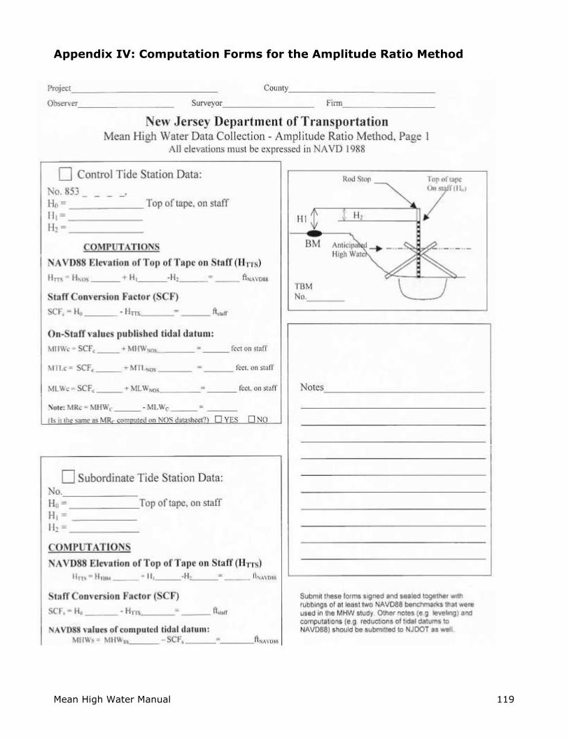
Mean High Water Manual 119
Appendix IV: Computation Forms for the Amplitude Ratio Method

Mean High Water Manual 120

Mean High Water Manual 121

Mean High Water Manual 122