mcimi/bos mountain skills - mountaineering ireland syllabus copyrb.pdf · it is recognised as the...
TRANSCRIPT

Mountain Skills
Course Syllabus
Mountaineering Ireland Sport HQ, 13 Joyce Way, Park West Business Park, Dublin 12 Tel: (+353 1) 625 1117 Email: [email protected]
http://www.mountaineering.ie

CONTENTS
Introduction
Syllabus
Mountain Hazards
Mountain Environment
Maps
Navigation
Route Planning
Personal Equipment
Emergency Procedures
Example MS1 & MS2 programmes
Mountain Skills Assessment
Introduction
First aid requirements
Logging your walks
Exemptions from MS1&2
The Successful Candidate
MSA Practical Assessment
MSA Written Test
Example Questions from the written test
Assessment check list
Further guidance
Your Mountain Skills log book
Important notes on using your MS logbook

INTRODUCTION
Mountaineering Ireland (MI) represents Hill walkers, climbers and mountaineers on the island of Ireland. It is recognised as the National Governing Body (NGB) by both the Irish Sports Council (ISC) and Sport Northern Ireland (SNI). BOS (Bord Oiliúint Sléibhe) is the Irish Mountain Training Board. It is responsible for mountain training in the Republic of Ireland and is a sub-committee of MI.
The BOS Mountain Skills (MS) scheme has two important functions within the structure of Mountain Training’ in Ireland.
1. To provide the theoretical and practical knowledge in basic navigation and hillwalking skills required to become a self-sufficient hillwalker within the upland regions of the UK and Ireland. The scheme is divided into the MS1 and the MS2.
2. To provide an assessment (Mountain Skills Assessment MSA) of basic navigation and hillwalking skills for those who wish to progress to BOS Mountain Leader awards This is reflected in the third block of the scheme, the two day MS Assessment (MSA), successful completion of which is a pre-requisite for registration on the BOS Mountain Leader scheme.
BOS recommends that MS1&2 training courses are run over a minimum of four days (two days each) with at least two evening/night sessions to allow for talks and night navigation exercises. However, a longer period may be desirable and necessary depending on students’ individual needs and previous experience. Eight weeks (minimum) must elapse between commencement of training and the two day Mountain Skills Assessment.
Who can run the BOS Mountain Skills Scheme? BOS approves individual ‘Course Providers’ (CP) to run the scheme (see www.mountaineering.ie for an up to date list). The CP is solely responsible for ensuring that the MS courses are run in accordance with BOS criteria/standards and for meeting BOS reporting requirements, including sending course confirmation to MI training office, submission of course reports where relevant, and keeping records in case of any follow-up queries by BOS.The providers are audited and moderated by BOS to ensure that standards are maintained. BOS does not approve centres or organizations. Activity Centres and independent companies who would like to run BOS training or assessment courses should arrange this directly with a CP approved by BOS. The course must be clearly identified as a BOS courses and the CP must be clearly identified in the promotion and advertising of the courses. The MS syllabus may also be used as ‘best practice guidelines’ for the development of other courses however, any ‘non-approved’ courses using the syllabus must not advertise, promote, or present their training courses in a way that may be construed as an official BOS MS scheme.
SYLLABUS OF THE MS SCHEME
On the following pages you will find details of the syllabus and a sample course programme. The latter gives an outline of each talk/lecture session on the course. A primary objective is given for each talk or practical exercise as well as essential elements of content. It is up to each ‘Provider’ to compile their own lecture notes, practical exercises etc. to reflect the syllabus and course notes. It is important that providers adhere to this framework so that students are not at a disadvantage if they change trainers, or when they attend assessments. This also helps students and providers if the student progresses to Mountain Leader training.
The development of the course programme is ongoing and revisions will be made if necessary, in line with trainers’ and students’ suggestions. Comments should be addressed to Mountain Skills Course, c/o MI Training Officer.
MOUNTAIN HAZARDS
Climatic hazards
• Temperature, precipitation, wind, lightning, humidity and snow.
• Reference to causes of mountain hypothermia.
Topographic hazards
• Steepness, ruggedness, special emphasis on remoteness.
• Reference to falls and drownings in hillwalking situations.
• Ability with reference to terrain and conditions.
Human hazards
• Health and fitness.
• Poor/lack of equipment.
• Poor route choice.
Mountain Environment
Access and land ownership
Introduction to the mountain environment
Introduction to the Leave No Trace programme
MAPS
• Map scales/symbols/conventional signs.
• Ordnance Survey maps/history, reliability, suitability, comparison of different scales.
• Terminology /features (e.g. corries, spurs, ridges, aretes etc.)
• Relief depiction including contours, crags.
• Orienteering maps.
• Grid references.

NAVIGATION
• Methods of calculating distance travelled and height climbed (Naismith’s Rule).
• Methods of measuring distances on ground (timing, pacing).
• Simple navigational techniques (aiming off, handrails, attack points etc.).
• Methods of location, cardinal points (solar, astral).
• Feature recognition (distant and near), self-location.
• Navigating across country using map alone.
• Theory of navigational tools including Silva-type compass, altimeters, and GPS.
• Map setting by compass: following bearing, backbearing and simple resection.
• Navigating across country using both map and compass.
• Slope aspect.
• Re-location techniques.
ROUTE PLANNING
• Route planning (choice of route, route card, bad weather alternatives, escape routes).
• Guidebooks and sources of information.
PERSONAL EQUIPMENT
• Equipment for hillwalking with reference to weight, bulk, and cost.
• Comparison and contrast of: footwear, outer clothing, headgear, gloves, middle layer garments, base layers.
• Bivouac bags and Bivouac tents.
• Rucksacks, torches, care of maps, whistle and other emergency signalling devices.
• First aid kits.
• Additional equipment for winter conditions.
EMERGENCY PROCEDURES
• Procedure in event of an accident.
• Prevention, diagnosis and treatment of mountain hypothermia, sprains, blisters, fatigue, and other typical ailments.
• Mountain rescue organisation in Ireland, including location of posts and teams.
• Call-out procedures

EXAMPLE MS1, MS2 & MSA PROGRAMMES
The following pages contains an example programme but many things can affect the way a provider delivers the MS scheme from, the weather to the experience and background of the students.
MOUNTAIN SKILLS 1 (MS1)
DAY 1
MS Scheme Introduction (Talk – 30 mins)
To introduce MS scheme and role of various organisations.
• The roles of the following organisations: MI, BOS, trainer.
• Scope of the Mountain Skills course and how it relates to the Mountain Leader course.
• Introduce (weekends) programme, instructors etc.
Maps: Suitability of Maps (Talk – 1 hour)
To explore some concepts of maps and the history and current suitability of maps for hillwalking.
• Properties of maps: aerial view, scale, .
• Scales and their effect on map detail.
Grid references
• National Grid.
• Four-figure grid references.
• Six-figure grid references.
• Conventional symbols including contours on walking maps – what they represent on the ground
• Suitability/reliability of OS and other production walking maps.
• Refer to scale, age, content: contour interval, crags, forests and tracks, building in isolated areas, rivers/streams.
• A brief history of mapping in Ireland: early 1800s, six–inch survey, for taxation purposes, mostly accurate on land below 1000 ft.
• Early 1:50000 – based on 1970s photography
• Rest of series – based on 1995 photography.
• Other production maps now available.
• Digital maps.
A variety of maps should be utilised to illustrate general points (eg. OS large scale maps, orienteering maps, walking maps, regional/atlas maps etc.) A selection of walking maps of different scales, style and production available in Ireland should also be shown.

Hillwalk (5 hours)
To develop map reading skills, understanding of symbols and basic contour patterns.
Navigation should be done using map only techniques when suitable.
• Conventional symbols and what they represent.
• Map-setting.
• Contour features: flat/steep ground, spur, valley, top, col/saddle, ridge, plateaus, re-entrants.
• Distance estimation – on map and ground. (Do not introduce measuring scales or Naismith calculations at this stage, but encourage estimation by eye, feel, and experience).
• Simple navigation technique – following handrail features, easy line features to start then graduating to easy contour features – spurs/ridges etc.
• Direction estimation/map setting.
• Terrain/maps – this exercise should be conducted on easy, moderate terrain. Use 1:50000 or 1:25000 maps most applicable to the area. Clearly identifiable points, both on the map and ground should be chosen for navigation legs.
Mountain Hazards (Talk – 1 hour)
To explore and illustrate some objective and subjective hazards of walking in the Irish mountains.
It can be beneficial to allow candidates time to produce their own list of suggested hazards under the following headings.
Weather: rain, cloud, cold, etc.
Topographic: cliffs, vegetation, loose rock, etc.
Human: health, fitness, attitude, etc.
A group discussion may then take place about formulating the chances and consequences of individual hazards or when combined with others.
Personal Equipment (Talk – 1 hour)
To discuss and show possibilities for hillwalking gear.
• Demonstrate examples of essential gear. Show possibilities for various options. Supplement with hand-out. Discuss the extra equipment needed for hillwalking in winter.
Depiction of Relief (Talk – 30 mins)
To illustrate different methods of showing relief in the mountains, with emphasis on contour features. Include how corries, spurs, ridges, valleys, peaks etc. are depicted.
• Discuss and show examples (if possible) of hill shading and contours and their relative merits.
• Concentrate on contour information – variation in basic patterns of shape, slope, and size of various features. The role of spot heights and crag symbols. A 3-D model or 3-D digital mapping example could be useful.

Mountain Environment (Talk – 1 hour)
To stimulate an appreciation of the mountain environment and impart a rounded understanding of how we can enjoy the hills responsibly. This topic will be addressed throughout the course as situations or ‘teachable moments’ arise on the hill, however there will normally be a dedicated discussion session, during which participants can contribute from their own knowledge and experience, and deepen their understanding of this subject.
Access and land ownershipAll land is owned; no legal right of access
The relationship between hillwalkers and landowners
MI access policy
Introduction to the Mountain Environment
o Special and fragile habitats
o Knowledge of flora, fauna, geology, history, placenames etc can add to our enjoyment
o Different uses of upland areas
o Changes in the mountain environment / pressures
Introduction to Leave No Trace programme
Guidelines for how we can enjoy the outdoors responsibly
Based on framework of 7 principles
Impact of our actions on other people, on soil, water and vegetation
How to learn more
DAY 2
Pacing and Timing (Talk/Practical – 1 hour)
To elaborate on rough distance estimation of previous day and introduce more accurate methods.
• Pacing exercise – determine number of double paces per 100 metres.
• Pacing – discuss variance in stride and how ground type and inclination alter number of paces taken, both up and down.
• Measuring distances on maps.
• Naismith’s rule
• Some timing calculations.
• Limitations over short distance, broken and steep ground.
Hillwalk (5.5 hours)
To develop map reading and more accurate means of measuring distance from the map and on the ground.
• Pacing: more direct and easier to understand than timing. Include a practical session and discuss how students can further refine their own double pace.
• Timing (Naismith’s Rule)
• Feature recognition.
• Terrain/maps – same as Day 1.
Introduction to compass
Grid references
• Advice on individual student training needs.
Route Planning (Talk – 30 mins) – also covered in MS2?
To demonstrate the importance of planning and preparation.
• Simple photocopy of map with marked route.
• Detailed route card showing times etc.
• Use of route card in emergencies for assistance information.
Debrief (Talk – 30 mins)
To offer general advice on course, answer queries etc., get feedback.
• Course comments – student and instructor.
• Need for practice in navigation.
• Details of next course etc.
MOUNTAIN SKILLS 2 (MS2)
DAY 1
Briefing (Talk – 20 mins)
To outline course and assess student progress.
• Analysis of students’ hillwalking activity since MS1.
• Introduce programme, instructors etc.
Emergency Procedures – Part 1. Mountain Hypothermia (Talk – 30 minutes)
To create an awareness of the concept of mountain hypothermia. A brief outline of the prevention, diagnosis and treatment of same.
• Physiology.
• Causes – environmental, individual.
• Signs and symptoms.
• Treatment – early, ongoing.
• Prevention.
• Also discuss other common ailments: sprains, blisters, fatigue, etc.
Introduction to Compass, (Talk/Practical 1 hour)
To introduce the use of the compass in hillwalking navigation Compass (40 mins)
• Compass points – cardinal points, 360 degree system.
• North – true, grid, magnetic.
• The concept of a bearing.
• Measuring bearings from a map by estimation, protractor.
• Theory of a Silva-type compass; taking bearings from a map.
• Grid and magnetic bearings.
• Walking on a bearing – short exercises.

Hill Walk (5 hours)
To develop map-reading skills, the concept of timing, and to practice the compass theory introduced earlier. Map and compass to be used in conjunction as much as possible.
• General map-reading, setting map by features.
• Setting map by compass.
• Timing calculations.
• Taking bearings from map.
• Walking on bearings.
• Back-bearings.
Feature recognition – close, distant
• Navigational techniques - attack points, aiming off, simple resection (i.e. party located somewhere on a definite linear feature. Bearing taken to a clearly identifiable point roughly at right angles. Intersection of plotted bearing and linear feature gives rough position).
Route Planning (Talk – 1 hour)
To explore and illustrate the principles of route planning from maps.
• The selection of walking routes from the map – in good/poor weather.
• Difficulties associated with steep ground, forestry, rivers, etc.
• Bad weather alternatives, escape routes.
• Use of route card.
• Various designs of route card.
• Preparation of route card – run through example.
• Use of guidebooks in route planning.
Night Navigation/Poor Weather Exercise (2/3 hours)
To practice navigation technique (particularly compass skills) in conditions of poor visibility.
• Discuss the reasons for, and actions taken, when caught out after dark.
• Short, simple navigation problems should be set, requiring a combination of tactics and compass work to solve. Clearly identifiable points, both on the map and ground should be chosen for navigation legs.
• Safety must be paramount and a strict time limit adhered to, to avoid disenchantment.
DAY 2
Emergency Procedures – Part 2. Mountain Rescue (Talk – 30 mins)
To outline procedures in the case of a mountain accident.
• Brief history of mountain rescue in Ireland, Mountain Rescue Ireland (formerly IMRA).
• Location of mountain rescue teams in Ireland.
• Accident procedure.
• Plan of action – risk to others, nature of injuries, weather, time available, party, equipment, terrain, location, and distance. Options – evacuation, sending for help.
• Call-out procedure.
• Role of the Air Rescue Helicopter, SARDA.

Steep/Broken Ground: Practical
To explore more rugged terrain, perhaps not normally encountered by hillwalkers, and develop an awareness in the student of his/her own abilities and limitations so that they remain at all times within full control of the situation on steep or broken ground.
• Safe movement in ascent and descent.
• Movement skills and technique.
• Route finding, maps etc.
• Movement of group.
• Hazards, problems of loose rock and other objective dangers.
Environmental considerations, particularly damage to vegetation.
Note on MS Steep/Broken Ground
While it may be difficult to definitively classify suitable steep ground for the MS course, it should only include ground where the use of the rope would not be contemplated. Many aspects of this part of the syllabus can be taught through outdoor discussions presented around a number of styles and degrees of steep/broken ground. Although it can be beneficially important to progress clients on to a range of more serious terrain in order to demonstrate judgement, this should be always kept within the perceived ability of the group. As areas of steep ground provide a refuge for flora and fauna, special care is required regarding choice of venue and minimising environmental impact.
Debrief, Assessment Briefing (Talk - 45 mins)
To answer queries, get feedback and to give an outline of the format of the MSA.
• Course comments – students, instructor.
• Requirements for those intending to do the MSA.
• Issue logbook.
• Sample paper.
• Advice on further training needs.

MOUNTAIN SKILLS ASSESSMENT (MSA)
Introduction
The purpose of the MSA is to ensure that the candidate has a good practical understanding of navigational techniques and other mountain skills (as outlined in the syllabus).
BOS approves suitably qualified and experienced providers to deliver and run the official BOS Mountain Skills Assessment. Applications for MSA should be made directly to an approved course provider. Not all approved training providers are approved to direct MSA;. A list of current approved providers is available from MI web site or the office. The assessment has both practical and written elements.
First aid requirements
First aid and incident management are recommended skills for any individual who journeys through the uplands of Ireland. A number of recognised first aid schemes are available that offer suitable training and assessment for the outdoor and upland environment. These schemes cover traditional first aid skills in a wilderness environment as well as dealing with specialist topics such as hypothermia and evacuation. Prior to attendance on a MS Assessment course candidates must hold a valid first aid qualification delivered by an approved provider and must involve at least 16 hours of instruction and include an element of assessment. An example of a suitable First Aid qualification for the Mountain Skills Assessment would be the Level 2 from Mountain Training Ireland, Rescue Emergency Care or Remote Emergency Care Mountain Skills Logbook Candidates are required to maintain a logbook of their mountaineering activities. (See the log book section for more information) Before attending a MSA you should ensure that you have completed and logged at least 14 hill/mountain walks in a variety of upland areas of Ireland. At least four of these walks should be within two months of the MSA. To be logged as a walk suitable fior the MSA it should fulfil the following criteria:
To take place in a recognised hill/mountain environment of Ireland. Not a repeat of an already logged walk. A minimum of four hours duration The candidate should have personally played an active part in organising
and implementing the day The route should not solely follow a waymarked way or path. The candidate should have presented themselves with an opportunity to use
relevant skills learnt through MS training.

Exemptions from MS1&2 Candidates who feel they have achieved the necessary experience may exempt themselves from formal training and take the MSA directly without having attended MS1 or MS2.. People who take this route typically have spent a considerable amount of time learning the necessary skills through a club, scouts, or other organisation. Candidates who gain exemption must present a BOS MS logbook on assessment, showing evidence of at least twice (28 days) the normal required experience. Such candidates are advised to become familiar with the MS syllabus before doing the MSA. Although training at ‘Mountain Skills’ level is designed to be very flexible, candidates must still gain the necessary experience and comply with logbook requirements. The course provider will be happy to discuss your individual case, give advice, and accommodate your individual circumstances.
The Successful Candidate
The successful candidate is someone who is confident and able to navigate from one major feature to another, e.g. col/summit/ large re-entrant/large spur/ major slope changes. They should be able to do this competently in clear weather and in mist or at night. They should be able to plan their day from the inception, look after themselves, adhere to good practice with regard to access and environmental matters, deal with minor emergencies, know what to do and who to contact in case of emergencies of a more serious nature, and know their limits in terms of type of ground encountered. As a candidate you will only be looking after yourself.
Mountain Skills Practical Assessment
The format of the MSA will be decided by the individual provider and will take into account weather, location, and time of year. Candidates can expect to be assessed on any part of the MS syllabus through a number of different formats over the two days. Below is a guide to example tasks that may be requested by the assessor for candidates to complete. However,
1. Do you possess the necessary equipment for a safe day in the hills?
2. Can you select and follow a route, not less than 1.5km in length to a given destination using the map only?
3. Can you complete a leg using compass and distance calculation. Leg length to be from 1km to 1.5km and to be executed with a lateral margin of error not exceeding 100m in 1km?
4. Can you correctly self locate on six occasions, only three of these to be on large obvious features?
5. Correctly identify six features, three of these to be further than 3km.
6. Can you demonstrate the ability to navigate adequately in conditions of reduced visibility, for example at night-time?
7. Do you demonstrate respect for the mountain environment?
8. Do you have the necessary experience to deal with simple ailments and a hypothetical first aid accident.
9. Can you demonstrate an ability to move on and choose a safe route over rough or steep ground.
MSA Written Test
The MSA is essentially a practical exercise but a written test is used as a tool to aid the candidate and assessor understand the level of knowledge that the student has of the MS syllabus. The written element is set, administered, and corrected by the provider responsible for the overall test. Candidates are allowed to use a compass and writing materials. The time allowed is generally 90 minutes. The exam takes

place at the start of, or shortly before, the practical assessment so that any weakness shown may be assessed while out on the hill.
Assessors may choose different formats and layout for the written test, including asking candidates to produce route plans, answer multiple choice type questions, or produce answers in a more detailed format. The written test can also be tested orally. The following examples demonstrate three formats that may be presented to candidates on assessment. Assessors may decide to use one particular format or a combination of all three.
1. Map and navigation calculations. 2. True or False general mountaineering questions. 3. Day walk plan and route card.
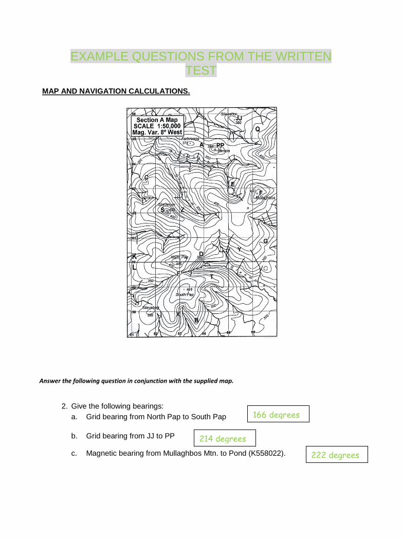
EXAMPLE QUESTIONS FROM THE WRITTEN TEST
MAP AND NAVIGATION CALCULATIONS.
2. Give the following bearings:
a. Grid bearing from North Pap to South Pap
b. Grid bearing from JJ to PP
c. Magnetic bearing from Mullaghbos Mtn. to Pond (K558022).
Answer the following question in conjunction with the supplied map.
166 degrees
214 degrees
222 degrees

1. State the time taken to travel in a straight line between these points at:
5 kph and 300m ascent per 1/2 hour:
a. From F (pt 447) to North Pap (415m) b. From PP to JJ.
3. What feature may best be described at the following letters:
A
B
C
D
4. In good visibility, state whether each of these pairs of points are intervisible (i.e. whether you can see one from the other). a. D and C
b. PP and JJ
c. F and S
5. (a) Give a 6 figure grid reference of point PP
(b) Give a 4 figure grid reference of point A
TRUE OR FALSE QUESTIONS
1. Very dry, cool, calm air greatly increases the risk of hypothermia. FALSE
2. Hypothermia is the drop of the body’s core temperature due to cold and exhaustion. TRUE
3. Hypothermia victims should be re-warmed rapidly in a hot bath. FALSE
4. Providing rest, extra clothes, shelter, and food are good ways to treat hypothermic victims. TRUE
5. Rainfall levels can be three times higher in the mountains than in the lowlands. TRUE
6. Wind speed increases very little as you go up, once you're above 300 metres. FALSE
7. Flooded rivers can be a major problem while hillwalking in Ireland. TRUE
8. If an accident happens to a person in a walking group one should ensure the casualty is warm and sheltered. TRUE
20 mins
Col/ Saddle
Spur
Re- entrant
Gully
No
Yes
Yes
K545046
K5504
54 mins

9. If an accident happens to a person in a walking group, the casualty can be easily carried off the hills with an improvised stretcher. FALSE
10. Only in hot countries do we need to worry about drinking liquid while we are hillwalking. FALSE
11. The International Mountain Distress Signal is six distinct blasts of a whistle or flashes of a torch followed by one minute’s silence. TRUE
12. Mobile phones are always a very reliable source of communication in the mountains. FALSE
13. When descending a convex slope, one often cannot see how steep the lower part of the slope is until one gets there. TRUE
14. The upper part of a conclave slope is steeper than the lower part. TRUE
15. There are no 1:25 000 scale maps of the Irish mountains. FALSE
16. Handrail features are always along ridges. FALSE
17. Aiming off involves navigating using the sun and the compass to get bearings. FALSE
18. Pacing is a mountaineering technique for walking very quickly. FALSE
19. Proper hillwalking boots, although important for comfort, have no real bearing on safety. TRUE
20. Ordnance Survey maps are always waterproof. FALSE
21. Most mountains in Ireland are privately owned land. TRUE
22. Walking along the centre of a muddy path causes less environmental damage than walking on the edge of the path. TRUE
23. Dogs are welcome on the hill provided they are kept on a lead. FALSE
24. Field gateways provide a good place to park on narrow country roads. FALSE
25. Sundew is an insectivorous (insect-eating) plant commonly found on the Irish mountains. TRUE
26. It’s OK to leave banana skins on the mountains as they are bio-degradable. FALSE
ROUTE PLANNING QUESTION
You are planning a one-day walk in Co. Kerry during March.
You have a car and are using Killarney for accommodation.
Your aim is to reach the summit of Carrauntohill .1039 (GR:V8084)
The weather forecast for Co. Kerry is ‘A cold front bringing rain and increasing winds veering from westerly to south westerly’
Plan a route for the above day including Expected route Emergency escape routes All other relevant information

MSA CHECK LIST The MSA is an opportunity for you to demonstrate your knowledge and personal ability of the basic hillwalking skills required for a safe and enjoyable journey within the hills of Ireland and the UK. Although set as an assessment process with a pass/deferral/fail result, it should also encompass an opportunity for further learning. To help make it a more enjoyable learning experience it is recommended that you ask yourself the following questions before putting yourself forward.
Have I completed BOS MS1 and MS2 and also clearly presented evidence of at least 14 quality walks in this log book?
Have I gained the required level of skill through experience and informal training and clearly presented evidence of at least 28 quality walks in this log book?
Have I got evidence to present at assessment of my valid and recognised first aid certificate?
Do I have suitable personal equipment to look after myself within the normal conditions found in the uplands of the UK and Ireland?
Do I currently have the personal fitness to spend two full days hillwalking, including a night navigation session?
Do I demonstrate respect for the mountain environment when I’m hillwalking?
Am I confident in my ability to demonstrate any of the navigational techniques presented through the MS syllabus?
Am I confident in my ability to understand my own personal limitations and make due assessments towards safety when moving across steep/broken ground?
Have I developed an interest and understanding of issues, past, present and future that have a bearing on hillwalking in Ireland?
Am I looking forward to spending 2 days out with a group of like minded individuals, walking, learning and getting an opportunity to show of my personal mountain skills?

YOUR MS LOG BOOK IMPORTANT NOTES ON USING YOUR MS LOG BOOK
Information should be presented in a clear and legible format; extra pages can be photocopied or downloaded from www.mountaineering.ie
Before applying to do the MSA you must have completed at least 14 walks or 28 if you have exempted yourself from training
At least four of these walks should be within two months of the MSA.
A ‘logged walk should fulfil the following criteria: o To take place in a recognised hill/mountain environment of Ireland. o Not a repeat of an already logged walk. o A minimum of four hours duration o The candidate should have personally played an active part in
organising and implementing the day o The route should not solely follow a waymarked way or path. o The candidate should have presented themselves with an
opportunity to use relevant skills learnt through MS training.
The MS log book should be presented to the director of assessment before the start of the MSA and should be accompanied by a current first aid certificate.

FURTHER GUIDANCE
The Mountain Skills scheme provides a firm grounding for the basic skills required to become a self-sufficient hillwalker within the normal conditions found in the upland regions of the UK and Ireland. Further training towards specialised skills needed for other aspects of mountaineering including, climbing, scrambling and winter mountaineering are also available through MI/BOS approved providers. Upon successful completion of the MSA you will be eligible to register for the Mountain Leader Scheme. This scheme trains the individual to lead groups in both the Irish and British hills by building on the skills learnt in the Mountain Skills Scheme and combining it with modules on leadership. You can gain further information on the BOS Mountain Leader scheme by visiting www.mountaineering.ie or talking to the provider or MI Training Officer. Mountaineering Ireland is the representative body for rambling, hillwalking, climbing and mountaineering in Ireland Bord Oiliúint Sléibhe (BOS) is the Irish Mountain Training Board. BOS develops and administers training schemes for hillwalking and climbing in the Republic of Ireland. For further information on BOS training schemes and a list of approved course providers contact: [email protected] or visit www.mountaineering.ie Mountaineering Ireland Sport HQ, 13 Joyce Way Park West Business Park Dublin 12 Tel +353 1 6251115 Fax +353 1 6251116