maynooth to westmeath border shared cycleway & footway...
TRANSCRIPT

Maynooth to Westmeath Border Shared Cycleway & Footway (38km)
EIA SCREENING
September 2017
Consulting Engineer Roughan & O’Donovan Arena House Arena Road Sandyford Dublin 18
Client Kildare County Council, Áras Chill Dara, Devoy Park, Naas, County Kildare
Client Meath County Council, County Hall, Navan, County Meath

ROD-AECOM Alliance Maynooth to Westmeath Border Shared Cycleway & Footway Consulting Engineers Meath County Council/Kildare County Council
Ref: 12.221 September 2017 Page i
Maynooth to Westmeath Border Shared Cycleway & Footway (38km)
EIA SCREENING
TABLE OF CONTENTS
1.0 Introduction and Background .................................................................................... 1 1.1 Introduction .......................................................................................................... 1 1.2 Background ......................................................................................................... 1 1.3 Development of the Project .................................................................................. 1
2.0 Project Objectives ....................................................................................................... 2 3.0 Description of the Proposed Development ............................................................... 2 4.0 Receiving Environment .............................................................................................. 3
4.1 Nature Conservation Designations ....................................................................... 3 4.2 Cultural Heritage .................................................................................................. 4 4.3 Landscape ........................................................................................................... 5
5.0 Defining the Requirement for EIA .............................................................................. 6 5.1 Legislation ........................................................................................................... 6 5.2 Guidance and Methodology ................................................................................. 9
6.0 Aspects of the Environment ....................................................................................... 9 6.1 Air Quality and Climate ........................................................................................ 9 6.2 Noise and Vibration.............................................................................................. 9 6.3 Soils and Geology ................................................................................................ 9 6.4 Hydrology ............................................................................................................ 9 6.5 Hydrogeology..................................................................................................... 10 6.6 Ecology (Flora and Fauna)................................................................................. 10 6.7 Archaeology, Architecture and Cultural Heritage ................................................ 10 6.8 Material Assets .................................................................................................. 10 6.9 Landscape and Visual Amenity .......................................................................... 11 6.10 Socio-economic ................................................................................................. 11 6.11 Resource and Waste Management .................................................................... 11 6.12 Risk to Human Health ........................................................................................ 11
7.0 Screening Conclusion and Recommendation ........................................................ 12

ROD-AECOM Alliance Maynooth to Westmeath Border Shared Cycleway & Footway Consulting Engineers Meath County Council/Kildare County Council
Ref: 12.221 September 2017 Page 1
1.0 Introduction and Background
1.1 Introduction Roughan & O’Donovan – AECOM Alliance (ROD-AECOM) have been appointed by Meath County Council / Kildare County Council to undertake the design and statutory procedures for a high quality cycleway and footway from Maynooth to Westmeath border as part of a larger proposal for a cycleway from Maynooth to Galway and Dublin to Maynooth. Integral to these initial stages of the planning and design process is to determine if a formal Environmental Impact Assessment (EIA) is required for the project. The findings of the EIA screening assessment undertaken by ROD- AECOM are presented in this report.
1.2 Background The Irish Government policy entitled ‘Smarter Travel: A Sustainable Transport Future’ which runs from 2009 to 2020 identifies certain key goals and objectives to be met in order to introduce a national sustainable transport network. A National Cycle Policy (NCP) was implemented to run alongside the main ‘Smarter Travel: A Sustainable Transport Future’ document. The NCP mission states that it wants to ‘create a strong cycling culture in Ireland’ while also ‘encouraging recreational cycling’. The NCP also outlines the importance of the National Cycle Network in attracting overseas tourists if the project is implemented.
1.3 Development of the Project The Department of Transport in September 2012 proposed the development of Ireland’s first cross-country off road cycle route between Dublin and Galway. The project was broken into two parts: Part 1 - Dublin to Maynooth: This part of the project is being developed by the National Transport Authority (NTA) where various sections are currently between feasibility and detailed design stage. Part 2 - Maynooth to Galway: This part of the overall project is to be developed under the National Roads Authority (NRA), and it is Part 2 which will be discussed further in this report. Maynooth to Westmeath Border Shared Cycleway & Footway The proposed Maynooth to Westmeath Border Shared Cycleway & Footway is a 38 km segment of a proposed cycle and pedestrian facility between Maynooth and Mullingar. The first Phase between Mullingar and the Westmeath / Meath county boundary was subject to a Part VIII Planning Application which was submitted and approved in 2012. The Mullingar to the Westmeath/Meath county boundary cycleway is currently under construction. Part II of the Maynooth to Mullingar Cycle Way aims to continue the route from Westmeath / Meath county boundary to Maynooth for a distance of 38km. The Proposed cycle route network aims to feed into the local and national tourism strategy by creating a tourism product which complements the existing natural, cultural and built heritage along the route. The cycle route has been identified as a significant marketing tool in the promotion of Ireland as a cycle destination and as part of the greater trans-European cycle route: EuroVelo 2: Capitals Route from

ROD-AECOM Alliance Maynooth to Westmeath Border Shared Cycleway & Footway Consulting Engineers Meath County Council/Kildare County Council
Ref: 12.221 September 2017 Page 2
Galway though the UK, Netherlands, Germany, Poland, Belarus and Russia as far as Moscow.
2.0 Project Objectives Tourism The cycle way is predominately targeted at overseas tourists interested in participating in a walking or cycling holiday. The proposed cycle way will tie in with the Dublin to Maynooth scheme which, when both completed will provide a high quality cycle route between the two major cities of Dublin and Galway. The success of the Great Western Greenway in Mayo is an excellent example of a cycle facility which has generated its own separate tourism industry and from which this project can draw some inspiration and experience. Health Domestic recreational cyclists are also a key target of the project as well as commuters who may be able to use parts of the proposed route to travel to and from work. By encouraging domestic users there are possible benefits to public health which will require further study. Economy The proposed cycle route will stimulate the local economy by generating a greater number of visiting tourists to areas along the route. The most recent figures available on cycle tourism show that 173,000 visitors to Ireland in 2011 engaged in cycling during their stay, spending an estimated €200 million. Some initial cost benefit analysis found that it could attract up to 30,000 international tourists per annum to Ireland. It is thought that the cycle route could generate as much as €15m per annum for the local economy. Safety The project will aspire to provide a "premium" cycle route that will offer the highest level of comfort and security for users in line with the best international practice. The cycle route itself will utilise local amenities such as canal towpaths and other greenways such as disused railways so that cyclists are segregated from live traffic where possible.
3.0 Description of the Proposed Development Overview The proposed cycle route aims to provide a safe environment for tourists and local users to cycle adjacent to the Royal Canal by providing a minimum 3m wide cycle track which for the majority of its length is separated from live vehicular traffic. Construction Methodology The proposed cycle route is to be located on the existing tow path which varies in width and surface type. Where the existing tow path consists of a grass bank a thin layer of topsoil, approximately 50mm is to be removed to form a formation layer where the proposed cycle path will be constructed. There are three main methods of construction which are to be implemented depending on local conditions.
ROD-AECOM Alliance Maynooth to Westmeath Border Shared Cycleway & Footway Consulting Engineers Meath County Council/Kildare County Council
Ref: 12.221 September 2017 Page 3
Quarry Dust The majority of the route will be surfaced using quarry dust which provides a fine gravely permeable surface. A thin layer of quarry dust will be spread on a 150mm of sub-base material which is to be laid using a paver to provide a smooth surface. The quarry dust surfacing will only be provided where vehicular traffic is restricted as it is only suitable for use of cyclists and pedestrians. Surface Dressing The proposed cycle route is located along a number of existing access roads on the tow path of the Royal Canal. These access roads are predominately used by local traffic to access houses and farm holdings. In order for cyclists and occasional motorised vehicles to use the route a Double Surface Dressing is required. It is proposed that the Double Surface Dressing will be laid on approximately 200mm of sub-base material due to the additional traffic loading. Bituminous Bound Surface (DBM) A bituminous bound surface is to be provided where the proposed route is located in the urban settings of Kilcock and Maynooth and in the one area approaching Cloncurry Bridge where the route is to be located on the public road. The depth of sub-base material will be dependent on the level of vehicular traffic which will be using the section of the proposed route. General Alignment The alignment of the proposed route is very good as it follows the smooth and flat alignment of the Royal Canal. There are some steep sections where the tow path accesses the local road network at bridge crossings but these are to be avoided if possible. Diverting the proposed cycle route under the existing road bridge is preferable. Drainage The existing drainage paths which are located along the tow path are to be kept if possible. A proposed cross fall of 2% will direct runoff towards the verge adjacent to the Canal. Drainage works such as installing filter drains or cut off ditches may be required at locations along the scheme but such works are envisaged to be limited.
4.0 Receiving Environment
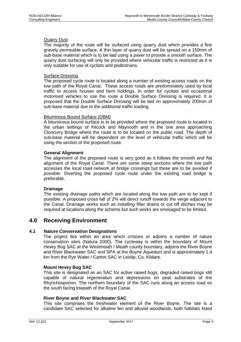
4.1 Nature Conservation Designations The project lies within an area which crosses or adjoins a number of nature conservation sites (Natura 2000). The cycleway is within the boundary of Mount Hevey Bog SAC at the Westmeath / Meath county boundary, adjoins the River Boyne and River Blackwater SAC and SPA at the Boyne Aqueduct and is approximately 1.4 km from the Rye Water / Carton SAC in Leixlip, Co. Kildare. Mount Hevey Bog SAC This site is designated as an SAC for active raised bogs, degraded raised bogs still capable of natural regeneration and depressions on peat substrates of the Rhynchosporion. The northern boundary of the SAC runs along an access road on the south facing towpath of the Royal Canal. River Boyne and River Blackwater SAC This site comprises the freshwater element of the River Boyne. The site is a candidate SAC selected for alkaline fen and alluvial woodlands, both habitats listed
ROD-AECOM Alliance Maynooth to Westmeath Border Shared Cycleway & Footway Consulting Engineers Meath County Council/Kildare County Council
Ref: 12.221 September 2017 Page 4
on Annex I of the E.U. Habitats Directive. The site is also selected for the following species listed on Annex II of the same directive – Atlantic Salmon, Otter and River Lamprey. River Boyne and River Blackwater SPA The River Boyne and River Blackwater Special Protection Area is of high ornithological importance as it supports a nationally important population of Kingfisher, a species that is listed on Annex I of the E.U. Birds Directive. The SAC adjoins the Royal Canal at the Boyne Aqueduct in County Meath. Rye Water / Carton SAC The Rye Water Valley / Carton SAC is designated for the habitat type: Petrifying springs with tufa formation (Cratoneurion) and two species of whorl snail: Vertigo angustior and Vertigo moulinsiana. The best examples of the habitat and species for which the site is designated can be found in proximity to Louisa Bridge in Leixlip.
Photograph 4.1: River Boyne, View from Boyne Aqueduct
4.2 Cultural Heritage
The history of this area is of varying wealth for cultural heritage resources. There are numerous recorded monuments, protected structures and industrial heritage sites present within and in proximity to the proposed cycleway. Of most significance is the industrial heritage which makes up the Royal Canal along with its associated features such as the lock gates, aqueducts and lock keepers cottages. In addition numerous railway features including bridges, stations and gate keepers cottages adjoin the canal for significant sections of the route. Towns along the route include Maynooth with its series of protected buildings and structures including St. Patricks church and college grounds. Protected monuments in state care in proximity to the route include Conolly's folly (approximately 2km east of Maynooth) and Maynooth Castle. A number of protected monuments and structures of archaeological significance are found along the route including ringforts, enclosures, ecclesiastical monuments and

ROD-AECOM Alliance Maynooth to Westmeath Border Shared Cycleway & Footway Consulting Engineers Meath County Council/Kildare County Council
Ref: 12.221 September 2017 Page 5
castles. Protected structures of architectural merit include numerous bridges the workings of the canal, the vernacular buildings of Kilcock and Enfield, the railway infrastructure of Enfield, the Boyne aqueduct and J. Furey’s Public house.
Photograph 4.2: Fureys Bar in Moyvalley
4.3 Landscape
The route follows for its entire length the Royal Canal which flows in an east west direction along the country boundaries of Meath and Kildare. The Meath Landscape Character Assessment defines the landscape adjacent to the Royal Canal as rolling lowland, which is more open due to larger arable field patterns and in general an area that is less densely vegetated. The landscape adjacent to the Royal Canal is very flat, but overgrown scrappy hedgerows and farmland restrict views. Views along the Royal Canal are available at the various stone bridges crossing the canal; these provide good vantage points and views across the lowlands. The lands along the corridor have been landscaped and enhanced where the canal crosses urban settlements. Canal locks are distinctive features of the water corridor. The Royal Canal is easily accessible at many points from the local roads – and sometimes runs parallel to this landscape feature. Consequently, many views of the canal are available, both from the local roads and from viewing points on bridges located along the canal corridor. Water corridors are generally visually enclosed, with highly localised areas of very distinctive character and high degree of visual consistency. The canal corridor flows though Maynooth, Kilcock and Enfield. Local roads run parallel to the corridor along some sections. Enfield is a small town with a few attractive buildings. Its built fabric is generally disjointed and accentuated by the N4 which cuts though the town. Kilcock and environs is a medium sized settlement area to the east of Enfield on the M4. The Royal Canal is a significant feature within the
ROD-AECOM Alliance Maynooth to Westmeath Border Shared Cycleway & Footway Consulting Engineers Meath County Council/Kildare County Council
Ref: 12.221 September 2017 Page 6
town which is supported by a number of vernacular buildings of architectural merit. There is a diverse mix of retail, commercial and residential development on the outskirts of Kilcock. In Maynooth the canal is well developed and makes up an important part of the town. The town is rich in cultural heritage and architectural significance including St Patrick’s college, Maynooth Castle and Carton House.
5.0 Defining the Requirement for EIA 5.1 Legislation
The legal requirements for Environmental Impact Assessment of a road development are defined in the Roads Act (1993) as amended by the Planning and Development Acts (2000 – 2011) and the Roads Act (2007), and by Regulations made under the Roads Acts, The European Communities (Environmental Impact Assessment) (Amendment) Regulations 1989 – 2001 and Council Directive 85/337/EEC (as amended by Directives 97/11/EC, 2003/35/EC and 2009/31/EC) and as codified and replaced by Directive 2011/92/EU of the European Parliament and the Council on the assessment of the effects of certain public and private projects on the environment and most recently amended by Directive 2014/52/EU. The proposed development falls under the requirements of the Roads Act as “Road” is defined within the act to include:
(a) any street, lane, footpath, square, court, alley or passage, (b) any bridge, viaduct, underpass, subway, tunnel, overpass, overbridge flyover,
carriageway whether single or multiple, pavement or footway, (c) any weighbridge or other facility for the weighting or inspection of vehicles, toll
plaza or other facility for the collection of tolls, services area, emergency, telephone, first aid post, culvert, arch, gulley, railing, fence, wall, barrier, guardrail, margin, kerb, lay-by, hard shoulder, island, pedestrian refuge, median, central reserve
Furthermore Cycleway is referred to in Section 68 of the 1993 Act as follows:
68 (1) In this section “cycleway” means a public road or proposed pubic road reserved for the exclusive use of pedal cyclists or pedal cyclists and pedestrians. (2) (a) A road authority may construct (or otherwise provide) and maintain
a cycleway. (b) Where a road authority constructs or otherwise provides a cycleway it shall by order declare either –
(i) the cycleway is for the exclusive use of pedal cyclists, or (ii) that the cycleway is for the exclusive use of pedal cyclists and pedestrians.
(c) any person who uses a cycleway in contravention of an order under paragraph (b) shall be guilty of an offence.
A summary of the relevant provisions of the Roads Acts in relation to Environmental Impact Statements for a public road development is set out below. Environmental Impact Statement (EIS) Section 50 of the Roads Act, 1993 as amended by Section 9(d) (i)(a) of the Roads Act 2007 states: “A road authority or the Authority shall prepare a statement of the likely effects on the environment (‘environmental impact statement’) of any proposed road development consisting of...

ROD-AECOM Alliance Maynooth to Westmeath Border Shared Cycleway & Footway Consulting Engineers Meath County Council/Kildare County Council
Ref: 12.221 September 2017 Page 7
(III.) Any prescribed type of proposed road development consisting of the construction of a proposed public road or the improvement of an existing public road.”
The prescribed type of road development as defined in S.I. No. 119 of 1994 paragraph 8 amended, is defined for the purpose of subsection (1) (a) (iii) of section 50 of the acts as follows:
(a) The construction of a new road of four or more lanes, or the realignment or widening of an existing road so as to provide four or more lanes, where such new, realigned or widened road would be eight kilometres or more in length in a rural area, or 500 metres or more in length in an urban area;
(b) The construction of a new bridge or tunnel which would be 100 metres or more in length
(c) Where a road authority considers that any proposed road development ...consisting of the construction of a public road or the improvement of an existing public road would be likely to have significant effects on the environment, it shall inform the Board in writing and where the board concurs with the road authority it shall give a direction to the road authority...”
Furthermore, S.I. No 119, 1994 was amended by the insertion of section (d) from Section 14, Paragraph (a) of the European Communities (Environmental Impact Assessment) (Amendment) Regulations 1999 with the following:
“(d) Where a proposed road development ... consisting of the construction of a proposed public road or the improvement of an existing public road would be located on:
(i) a special area of conservation, (ii) a site notified in accordance with Regulation 4 of the European
Communities (Natural Habitats) Regulations, 1997 ( S.I. No. 94 of 1997 ),
(iii) an area classified pursuant to paragraph (1) of (2) of article 4 of Council Directive No. 79/409/EEC of 2 April, 1979, on the conservation of wild birds (O.J. No. L 103, 25 April, 1979),
(iv) a site where consultation has been initiated in accordance with article 5 of Council Directive 92/43/EEC of 21 May, 1992, on the conservation of natural habitats and of wild fauna and flora (O.J. No. L 206, 22 July, 1992),
(v) land established or recognised as a nature reserve within the meaning of section 15 or 16 of the Wildlife Act, 1976 (No. 39 of 1976)
The road authority concerned shall decide whether the proposed road development would or would not be likely to have significant effects on the environment. “
Where a development is sub-threshold, the decision as to the requirement for EIA must be decided on a case by case basis. The legislative requirements that deem whether an Environmental Impact Assessment is mandatory for a project are outlined in Schedule 5 of the Planning and Development Regulations 2001–2015. The characteristics of the Project which must be considered are outlined within Annex III of the EIA Directive 2014/52/EU, with particular regard to the following: 1. Characteristics of proposed development
ROD-AECOM Alliance Maynooth to Westmeath Border Shared Cycleway & Footway Consulting Engineers Meath County Council/Kildare County Council
Ref: 12.221 September 2017 Page 8
The characteristics of proposed development, in particular:
the size of the proposed development;
Cumulation with other existing and/or approved projects;
the use of natural resources,
the production of waste,
pollution and nuisances,
the risk of accidents and/or disasters which are relevant to the project concerned, including those caused by climate change, in accordance with scientific knowledge;
The risks to human health (for example due to water contamination or air pollution).
2. Location of proposed development The environmental sensitivity of geographical areas likely to be affected by proposed development, having regard in particular to:
the existing land use,
the relative abundance, quality and regenerative capacity of natural resources in the area,
the absorption capacity of the natural environment, paying particular attention to the following areas:
a. wetlands, b. coastal zones, c. mountain and forest areas, d. nature reserves and parks, e. areas classified or protected under legislation, including special
protection areas designated pursuant to Directives 79/409/EEC and 92/43/EEC,
f. areas in which the environmental quality standards laid down in legislation of the EU have already been exceeded,
g. densely populated areas, h. landscapes of historical, cultural or archaeological significance.
3. Characteristics of potential impacts The potential significant effects of proposed development in relation to criteria set out under paragraphs 1 and 2 above, and having regard in particular to:
the extent of the impact (geographical area and size of the affected population),
the transfrontier nature of the impact,
the magnitude and complexity of the impact,
the probability of the impact,
the duration, frequency and reversibility of the impact. Having regard to the above, the proposed scheme does not register on Schedule 5 as a project automatically requiring EIA. It does however lie within the boundary of Mount Hevey Bog SAC and adjoins the River Boyne and River Blackwater SAC and SPA at the Boyne Aqueduct. As these sites are specifically referenced under Criteria 2 of Schedule 7 it is important that it is determined at this stage whether or not EIA is required. All other criteria listed under Schedule 7 have been assessed
ROD-AECOM Alliance Maynooth to Westmeath Border Shared Cycleway & Footway Consulting Engineers Meath County Council/Kildare County Council
Ref: 12.221 September 2017 Page 9
and determined with regard to the scale of the proposed project, the location of the project and the characteristics of the project. These are further considered in sections six for each environmental aspect.
5.2 Guidance and Methodology The following documents were reviewed for the purpose of this assessment:
European Commission Guidance on EIA Screening (2001); and
Department of the Environment, Heritage and Local Government Guidance for Consent Authorities regarding sub-threshold Development (2003).
The first two stages in the EIA process are ‘Screening’ and ‘Scoping’. Screening is that part of the EIA process which determines whether an EIA is required for a particular project; Scoping is the activity of deciding on matters to be investigated as part of the EIA. The EC Guidance on EIA Screening highlights that these two can overlap as a preliminary assessment of the environmental issues may be undertaken to assist in the screening decision. Therefore in order to determine whether or not this project requires an EIA a preliminary assessment of the topics which are required to be considered within an EIA is undertaken below in Section 6.0.
6.0 Aspects of the Environment 6.1 Air Quality and Climate
The Maynooth to Westmeath Border Shared Cycleway and Footway involves the design and construction of a high quality cycling and pedestrian facility along the length of the Royal Canal. The objective of the project is to provide a facility for cyclists and pedestrians thus having no significant operational impact on Air quality and climate. The construction phase of development aims to provide a bound or unbound surface 3 m in width for approximately 38km. It is considered that the level of construction traffic required for a project of this scale will have no impact on the local air quality or climate; neither will a construction project of this scale result in any significant generation of dust.
6.2 Noise and Vibration
The proposed cycleway will largely be active in daytime hours only. At operation an increase in the number of cyclists or pedestrians will have negligible impact on noise or vibration in the local environment. It is also considered that the level of construction traffic and construction operations required for a project of this scale will not result in the creation of any significant levels of noise or vibration. Furthermore works will be carried out in compliance with BS5228: Part 1 and the European Communities (Noise Emission by Equipment for Use Outdoors) Regulations, 2001 which will ensure a controlled level of noise during construction phase.
6.3 Soils and Geology Due to the scale of the project and the minimal nature of excavation required it is not anticipated that there will be any significant impacts to soils and geology as a consequence of the construction or operation of the scheme.
6.4 Hydrology The principal potential impacts to surface water are associated with discharges to the receiving watercourses – in this case the Royal Canal.
ROD-AECOM Alliance Maynooth to Westmeath Border Shared Cycleway & Footway Consulting Engineers Meath County Council/Kildare County Council
Ref: 12.221 September 2017 Page 10
It is anticipated that there will be no impact to hydrology or water quality during the operational phase. The cycleway will not create traffic pollutants impacting on the water system. During construction there is the potential for pollution of the canal from sediment loading and associated anthropogenic polluting substances as a result of surface water run-off or spills on site. It is considered that the enforcement of industry best practice pollution prevention measures will prevent the occurrence of a pollution event (for example CIRIA Guideline Document C532 Control of Water Pollution from Construction Sites and C648 Control of water pollution from linear construction projects).
6.5 Hydrogeology Hydro-geological assessment addresses the potential impact of the proposed project on groundwater features and groundwater flow regime. As the cycleway will be largely on the existing towpath and there will be no requirement for any significant cut or fill, it is considered that there will be no significant impact on the groundwater regime during either construction or operation.
6.6 Ecology (Flora and Fauna) The route lies alongside and within the Mount Hevey Bog SAC and adjoins the River Boyne and River Blackwater SAC and SPA at the Boyne Aqueduct. A Habitats Directive Screening for Appropriate Assessment is required in order to address the potential impact on Natura 2000 Sites (SAC, SPA). This Assessment addresses the potential impact the project may have on the Qualifying Features (Habitats and Species) of the designated sites and the conservation objectives for same. The route is within the Royal Canal pNHA. The Royal Canal pNHA comprises a central channel and banks on either side. Numerous different habitats are found within the canal boundary including hedgerow, tall herbs, calcareous grassland, reed fringe, open water, scrub and woodland. Otter spraints are found along the towpath particularly where the canal passes over a river or stream and bats use roosts nearby and potentially in canal overbridges. The value of the canal lies more in the diversity of species it supports along its linear habitats than in the presence of rare species; it crosses though much agricultural land and therefore provides a refuge for species threatened by modern farming methods. The entire canal as part of an ecological mapping exercise was mapped for habitats and species as part of this project. This exercise has informed the design of the cycle route and where necessary mitigation measures are provided within the Part 8 Planning Application in order to minimise the impact on the ecological environment. The presence of habitats and species identified along the canal does not warrant the need for an EIS to be completed.
6.7 Archaeology, Architecture and Cultural Heritage As highlighted above (Section 4.2), the area is relatively rich in cultural heritage possessing a number of recorded monuments and protected structures. Despite this it is considered that the cycleway project will have no direct impact on any monuments or structures other than the Royal Canal itself and should, with the correct archaeological and architectural heritage supervision, serve to enhance these sites through improved access and interpretation. Identification of all heritage features and appropriate mitigation measures will be included as part of the Part 8 Application Report.
6.8 Material Assets A construction project may affect assets if it involves any of the following:

ROD-AECOM Alliance Maynooth to Westmeath Border Shared Cycleway & Footway Consulting Engineers Meath County Council/Kildare County Council
Ref: 12.221 September 2017 Page 11
Acquisition of land;
Loss of land used by the community;
Demolition of private property;
Revaluation of or change in the development potential of adjoining lands / properties.
The proposed scheme does not require the demolition of any buildings nor the acquisition or permanent interference with lands used by the community; in fact it will provide an asset to the community. There are no planning applications pending over the lands required and the lands are not zoned for development within the Meath or Kildare County Development Plan, hence there is no impact on the development potential of the adjoining lands.
6.9 Landscape and Visual Amenity The nature of the cycleway being principally an overlay on the existing towpath is unlikely to have any significant impact on the Royal Canal landscape. The existence of this linear feature allows to the incorporation of the cycleway into an already altered environment. In addition at operation the cycleway will not detract from existing views or views to or from any heritage features present. In fact the project has the potential to have a positive landscape and visual impact through the provision of additional views and interpretation of the area and its heritage. During construction the presence of plant and machinery will detract from certain views. However this is considered to be only a slight temporary impact which is easily offset by the benefits accrued at the operational stage.
6.10 Socio-economic The objective of any socio-economic assessment is to examine the potential impact of the construction and operation of the proposed development on the local community and business activities in the local area. The opening of the cycling trail will have beneficial impacts as it will attract people to the area thereby having a knock on economic effect with respect to hotels, guesthouses, B+Bs, recreational tourism, restaurants, etc. Similarly during construction the influx of construction workers will benefit the local economy. This is supported by the evidence gathered in support of similar projects, for example a survey by Mayo County Council concluded that 145,000 persons used the Great Western Greenway (Westport – Achill) in Mayo in its first year of opening.
6.11 Resource and Waste Management The key phase with regard to resource and waste management is the construction phase. As the cycleway is largely an overlay there will be no requirement for any significant cut or fill. It is therefore considered that there will not be a significant amount of waste generated from the construction of the scheme and efforts will be made to reuse material on site where possible thus minimising waste.
6.12 Risk to Human Health Temporary negative impacts to human health may be likely during the construction phase due to noise, dust, air quality, visual and traffic impacts. These impacts will be short term in nature and are not considered to be significant. The proposed new access points will have the additional benefits of improving connectivity along the Royal Canal corridor and therefore will have a positive impact on human health.
ROD-AECOM Alliance Maynooth to Westmeath Border Shared Cycleway & Footway Consulting Engineers Meath County Council/Kildare County Council
Ref: 12.221 September 2017 Page 12
7.0 Screening Conclusion and Recommendation Through this Screening process, it is concluded that the proposed Dodder Greenway does not exceed any of the thresholds that trigger the mandatory requirement for Environmental Impact Assessment. As the proposed development is sub-threshold, it has, therefore, been assessed on a case-by-case basis in accordance with the Criteria for Determining Whether or Not a Development Would or Would Not be Likely to have Significant Effects on the Environment as outlined within Annex III of the EIA Directive 2014/52/EU. Having regard to Annex III of the EIA Directive 2014/52/EU and the guidance contained in the Department’s Environmental Impact Assessment Guidance for Consent Authorities regarding Sub-Threshold Development (2003), and in particular:
The size and design of the whole project;
Cumulation with other existing and/or approved projects;
The use of natural resources, in particular land, soil, water and biodiversity;
The production of waste;
Pollution and nuisances;
The risk of major accidents and/or disasters which are relevant to the project concerned, including those caused by climate change, in accordance with scientific knowledge; and
The risks to human health (for example due to water contamination or air pollution).
It is considered that the environmental effects arising from the project will generally be localised, minor in nature and occur principally during the construction phase. However due to the potential impact on the SAC and SPA present it is recommended that an Ecological Survey and Habitats Directive Screening for Appropriate Assessment be completed and submitted alongside any future planning application. This conclusion is reflected in DEHLG Guidance for Consent Authorities regarding sub-threshold Development (2003) which quotes at Section 5.25 that ‘where an assessment is considered necessary under the Habitats Directive, it does not automatically mean that an EIA is the necessary form of assessment’.