mayflower, standish conservation area appraisal · list of illustrations image 1: mayflower...
TRANSCRIPT

Mayflower, Standish Conservation Area Appraisal April 2010
Environmental Services Department Civic Buildings New Market Street Wigan WN1 1RP

Contents Appraisal 1. Introduction 1.1 Purpose of this appraisal
1.2 Community Involvement
1.3 Planning Policy Context
2. Summary of Special Interest 2.1 Key Characteristics
2.2 Justification for Designation
2.3 Boundaries & extent of Conservation Area
2.4 Boundary Changes
3. Historical Development 3.1 History
3.2 Archaeology
4. Location and Landscape Setting 4.1 Geographical Location
4.2 Topography and Landscape
5. Spatial Analysis 5.1 Key Views
5.2 Open Spaces, Focal Points, Landscaping & Trees
6. Definition of Special Interest 6.1 Current Activities and uses
6.2 Architectural & Historic Character
6.3 Building Materials & Local Details
6.4 Buildings of Townscape Merit
6.5 Unlisted Buildings of Townscape Merit
6.5 Public Realm: Floorscape, Street Lighting & Street Furniture
6.6 Historical Associations
7. Issues

7.1 Positive
7.2 Negative
8.0 Consultation 8.1 Keep the Conservation Area as it is
8.2 Impose an Article 4 (2) Direction upon the Conservation Area
8.3 Extend the Conservation Area
8.4 De-designate the Conservation Area
Bibliography Appendices Appendix 1: Maps Appendix 2: Management Proposals Appendix 3: Unitary Development Plan Policies Implications of Conservation Area Status Glossary of Terms Appendix 4: Consultation Useful Information
We can make this information available in other formats and languages on request. Contact us at: Environmental Services, Civic Buildings, New Market Street, Wigan. WN1 1RP Phone: Conservation Officer - 01942 404253
Email: [email protected]

List of Illustrations
Image 1: Mayflower Conservation Area Map: showing boundary
Image 2: Worthington Hall Image 3: Mile Post, Chorley Road
Image 4: View over lake/lagoon towards Lakeside Cottages
Image 5: 1840 map, showing Worthington Paper Mill
Image 6: 1890 map, showing Standish Bleach works and Lakeside Cottages
Image 7: 1920’s map, showing Lakeside and Mayflower Cottages
Image 8: 1930’s historic map
Image 9: Industrial units on bleach works site
Image 10: Former bleach works
Image 11: Gate Lodge
Images 12 and 13: Former bleach works wall, Chorley Road
Image 14: View from jetty towards Lakeside and Mayflower Cottages
Image 15: View from the jetty towards Lakeside Cottages
Image 16: View across lake/lagoon towards Worthington Reservoir
Image 17: View towards Mayflower Cottages from Trevore Drive
Image 18: View over lake from Trevore Drive
Image 19: Greenspaces within new development
Image 20: Green space and planting within new development
Image 21: The Lake/Lagoon within Mayflower Conservation Area
Image 22: View across the Lake towards Trevore Drive
Image 23: Land to the rear of Mayflower Cottages Image 24: Open space area to the front of Gardinar Close
Image 25: Mayflower Cottages
Image 26: Location of Tree Preservation Orders in Mayflower Conservation Area Image 27: Lakeside Cottages
Image 28: Mayflower Cottages: Queen Anne style
Image 29: Architectural details at Lakeside Cottages Image 30: Italianate architectural style: Lakeside Cottages
Image 31: Window detailing at Lakeside Cottages
Image 32: Lakeside Cottages
Image 33: View of Lakeside Cottages across the Lagoon
Image 34: View of Lakeside Cottages during demolition of the bleach works
Image 35: Mayflower Cottages

Image 36: Mayflower Cottages: architectural details Image 37: Former Engine House
Image 38: Former Engine House: Front Elevation Image 39: Former bleach works wall Image 40: Former Bleach works Gatehouse Image 41: Former Bleach works Gatehouse: front elevation
Image 42: Brick detailing on front gables to Mayflower Cottages
Image 43: Brick detailing to gable ends on new development
Image 44: Brick detailing to rear gables on new development
Image 45: Lake/Lagoon towards Worthington Reservoir Image 46: Lake/Lagoon towards Lakeside/Mayflower Cottages
Image 47: Road surface in new development
Image 48: Raised drain covers on pavement
Image 49: Replacement windows on Mayflower Cottages
Image 50: Allotment land to the rear of Mayflower Cottages

1. Introduction 1.1 Purpose of this Appraisal Conservation area appraisals are a method by which local authorities can evaluate the important architectural and historic features within an area and provide a basis for character assessments and produce a management strategy. English Heritage as statutory advisor to the government on the historic environment, defines a conservation area as being “an area of special architectural or historic interest, the character or appearance of which it is desirable to preserve or enhance”. Conservation areas are designated in legislation under the provision of Section 69 of the Planning (Listed Buildings and Conservation Areas) Act 1990. Under Section 71 of the same Act, local authorities are required to formulate and publish proposals for the preservation and enhancement of any conservation areas under their jurisdiction. Section 72 specifies that when making decisions on development applications within a conservation area, special attention must be paid to the desirability of preserving or enhancing the character or appearance of that area. This document has been produced in response to these statutory requirements and in accordance with the governments national planning policy note “Planning Policy Guidance 15: Planning and the Historic Environment” (PPG15). English Heritage has also published guidance which includes “Conservation Area Appraisals: Defining the special architectural or historic interest of conservation areas” (1997) and “Guidance on Conservation Area Appraisals” (2005) Conservation Area Appraisals are a way of defining the special interest of an area, identifying any issues which may threaten the special qualities of that area and providing guidelines in order to prevent damage to and achieve enhancement within that area. This document should provide basis on which planning applications for development within the conservation area can be assessed to ensure high quality development which is not detrimental to the character or appearance of the conservation area. 1.2 Community Involvement In accordance with Part 6, Section 24(4) and Part 6, Section 36 of the Town and Country (Local Development) (England) Act 2004, Wigan Council adopted its Statement of Community Involvement on the 12 July 2006. This statement sets out the council’s policies for involving the community in the wider planning processes, including the preparation of the Local Development Framework and Conservation Area Appraisals. It provides advice as to how and when communities and interested stakeholders can become involved in the planning process. In line with this statement when undertaking this assessment of Mayflower, the local community and interested stakeholders including elected members were asked to contribute their thoughts, opinions and suggestions regarding the current conservation area and draft report. The preparation of the Conservation Area Appraisal has been subject to public participation and involvement of the local community. A strong community spirit exists in Mayflower and an active residents group has been in place for some time. Further detail regarding the Mayflower Conservation Area Appraisal consultation is set out in Appendix 4 to this document.

1.3 The Planning Policy Context This document should be read in context with the wider policy framework of land use, planning and development. For Wigan Borough this is the Wigan Replacement Unitary Development Plan, adopted in April 2006. Wigan Unitary Development Plan This document contains the Council’s adopted planning policies and proposals for the use and development of land for the period 2006-2016. Under Policy EV4 ‘Conservation’, the council conserves the historic built environment through not permitting development which would harm the character or appearance of a conservation area. To this end, the policy maintains the character and appearance of its conservation areas through protecting buildings that lie within them, ancient monuments, sites, buildings and structures of archaeological interest and historic landscapes. Buildings of local interest are protected and enhanced through the application of development control powers. (see Appendix 3 for expanded UDP policies). The Conservation Area Appraisal may be a material consideration in the determination of planning applications affecting Mayflower. Current planning policy also provides planning authorities with additional permitted development controls within conservation areas. Article 4(2) directions can be applied within residential areas to give extra protection to their character and appearance. These effectively remove specific permitted development rights within the conservation area therefore introducing the need for planning permission. They can be used to control the installation of satellite dishes, cladding, removal of windows and doors and the fitting of dormer windows. Separate to this, the demolition in whole or in part of any building within a conservation area requires conservation area consent and there are also controls over works to and the removal of trees within conservation areas.

Mayflower Conservation Area Mayflower Conservation Area was designated on 20th November 1989 and lies to the east of Chorley Road, centred on Red Rock Lane and the River Douglas. The Conservation Area is of considerable architectural, industrial archaeological and historical interest. Image 1: Location Plan of Mayflower Conservation Area (showing boundary)
2. Summary of Special Interest 2.1 Key Characteristics Mayflower Conservation Area is predominantly a residential area with some parcels of open space, woodland and landscaping within its boundary. It lies within a semi-rural setting, being bounded to the north and east by Green Belt, and largely characterised by mature trees, and substantial properties set in large grounds, particularly along Chorley Road (to the north), and open fields (to the west). Within the Conservation Area there are several notable historic buildings, including Lakeside

and Mayflower Cottages and retained structures from the former Standish bleach works. The engine house, the former bleach works wall and the gatehouse at the entrance to the former industrial premises are significant reminders of the area’s industrial past. The Conservation Area extends south to include Jolly Mill and its stone lined mill race. A mill on this site was established in 1348, but is now occupied by a more recent property dating from the (18th and (19th. Much of the northern part of the site was occupied by Standish Bleach works. In addition to the industrial archaeological and historical interest of these premises, architectural interest derives from the vernacular industrial style of Jolly Mill with its cottage style and Yorkshire sash windows. The functional tradition using debased classical and other decorative architectural features is evident on several of the Bleach Works Buildings, especially on the Chorley Road elevation of the main factory, the warehouse with its clerestory roof to the south and the weigh bridge house. Numbers 1 to 20 Lakeside Cottages in Italianate style of 1857-62 are listed as of special architectural or historic interest, as is the cast iron mile post outside the former bleach works on Chorley Road. Mayflower Cottages date to the late (19th are in the Queen Anne Revival style. There are many key characteristics which stand out in the conservation area and contribute towards defining the area as one of special architectural and historic importance, for example: • Dominance of red brick building material; • Slate roofing materials; • Mature trees and woodland; • The ‘lagoon’ or lake • Open space. This area of Standish is steeped in history and there are a couple of notable historic buildings and structures which currently lie just outside the boundary of the Conservation Area which are of interest. Of particular significance is the Grade II* listed former Worthington Hall, which is located on Chorley Road, opposite the former bleach works site and is now a working farm. This property was the ancestral home of the Worthington family since the C16th. Today, the hall is now a farm-house, and the property has been altered both internally and externally, however, much of the timber construction can be seen to the external elevation.
Image 2: Worthington Hall:
Above the door is the inscription: ‘Edward Worthington 1577’, with the initials M.D. in spandrel.

Image 3: Mile post, Chorley Road
The mile post is dated 1837and located outside the former bleach works on Chorley Road. It is Grade II listed and cast iron in construction and manufactured by the Haigh Foundry. The milestone has a curved head with decorative scrolled top '3 miles to Wigan 5 miles to Chorley'. 2.2 Justification for Designation Mayflower conservation area is relatively large in size, currently covering an area of 12.85 hectares. It has been characterised as an area of special industrial and residential significance but is now dominated by residential properties. The former Standish Bleach Works, Lakeside and Mayflower Cottages are an important example in the Borough of a planned industrial settlement. The houses (Lakeside and Mayflower Cottages) were built for the factory workers by the paper and bleaching companies. An essential characteristic of the planned nature of the cottages is the presence of open drying grounds and allotments, especially to the rear of Mayflower Cottages. The planned industrial settlement at Mayflower dates from the late 19th century and originally included Lakeside Cottages, Mayflower Cottages and the extensive Standish Bleach works site (now a modern housing estate). The original settlement was relatively unique in the borough, and was only one of a few purpose-built planned industrial settlements in the country. 2.3 Boundaries and Extent of the Conservation Area The boundary of the conservation area covers the northern edge of the old bleach works site and continues south across Red Rock Lane. The boundary stretches from Chorley Road in the east to the rear of Mayflower Cottages in the west. To the south, the Conservation Area incorporates a large area of woodland, then follows the line of Chorley Road with a small arm reaching further south to take in Jolly Mill (and associated cottages). The River Douglas runs through the Conservation Area (partly culverted) joining the boundary to the south, then west of Trevore Drive, before

winding its way underground, and re-emerging to the far north of Lakeside Cottages and to the south east of Worthington Reservoir. Development in the Conservation Area is fairly dense in nature, with buildings and structure from the mid to late C19th (Lakeside and Mayflower Cottages, the lake and the selection of former bleach work buildings), and more recently, the modern residential development on the bleach works site (Worthington Park). It is the broken line of terraced properties of Lakeside and Mayflower Cottages that provide the architectural and historic interest to the Conservation Area. These, together with the lake/lagoon, and the scattering of retained (and refurbished) bleach work buildings and structures integrated within the modern residential development, add an interesting character to the area.
Image 4: View over lake/lagoon towards Lakeside Cottages
2.4 Boundary Changes Under the Planning (Listed Buildings and Conservation Areas) Act 1990, section 69 (2) the Council has a duty to review its conservation areas and to determine whether any parts or any further parts of their area should be designated as conservation areas. An important part of the appraisal process has been to review the boundary of the Conservation Area and where it should be drawn. It is crucial that the wider setting of the Conservation Area is considered in order to assess the appropriateness of the current boundary. There are some significant features which lie outside the original Mayflower Conservation Area boundary. These include a selection of historic properties, landscaping, wooded areas with mature trees, and important and significant water
features, namely the River Douglas, Worthington and Arley reservoirs, which provide a valuable ecological and recreational resource. Green spaces and trees are recognised as vital elements of many conservation areas and are an important biodiversity resource. Equally, the contribution of the water features and mature trees to the character and appearance of the area is significant. The previous conservation area boundary was drawn up to include the planned industrial settlement of the Standish Bleach works. As a result, many features of the wider area, which are of historical and visual significance, together with other important considerations, such as vistas and views to the north of the area were ignored. The current proposal to extend the boundary northwards would ensure that all significant historical elements, dating from Medieval to early (19th and (20th developments, such as Kilhey Court and Lakeside Court, would figure in a single conservation area. Additionally, the old boundary did not fully take into account the historic development of the settlement and consequently left out some key buildings, sites and aspects. The revision to the boundary of Mayflower Conservation Area is based on strong historical, topographical, and landscape considerations for these elements to be included. In essence, these revisions help preserve the wider setting of the historic settlement at Mayflower, and include significant elements of the historic landscape adjacent to, and outside, the current boundary. The relationship and significance of the River Douglas to the Conservation Area is an important one, particularly in respect of its integral role in the industrial development and growth of the area. 3. Historical Development 3.1 History Roman Period There is no evidence of Roman occupation within Mayflower Conservation Area itself. Mayflower Conservation Area is however, situated near to the large Roman settlement believed to have been established in Wigan (Coccium). Medieval Period The first recorded activity in the area was in 1348 when the operation of a water-powered mill was documented. Reference to a mill is also acknowledged several times in the inquisitions and settlements of the Worthington family over the following two centuries. Jolly Mill and its stone lined mill race was established in 1348 with the present building dates from the (18th and (19th. In the (14th, the site to the north (most recently occupied by the Standish Bleachworks) was the site of Worthington Corn Mill. The earliest industry present on the site was corn grinding; with the mill utilising the River Douglas, which flows through the site, in the corn grinding process and this was operational until the late 17th century.

Post-Medieval Period During this period the area of Lancashire (of which Standish and Wigan was part) underwent extensive changes as a result of the industrial revolution in the 17th and 18th centuries. By the late (18th a water mill was present, followed by a paper mill, which ceased trading in 1883. From 1886, cloth bleaching and subsequently dyeing was established. In 1889, the Bradford Dyer’s Association Ltd, took over the concern, and for a period introduced cloth dyeing but this was discontinued in 1907 Paper manufacturing is known to have been occurring on site in 1788. During the next 100 years paper manufacture was developed at the site and several patents were developed to improve production rates. Very little is known about the site during this time however, the 1849 OS map of the area shows considerable expansion when several new buildings and reservoirs appear. In 1884 the paper mill was purchased by Taylor and Co, who converted the mill for use as a bleaching works. The mill was bought over and expanded again during the late 19th century and dyeing was introduced to the operations. The site is annotated on the 1907 OS map as ‘Standish Bleach and Dye Works’. It was also during the late 19th century that the industrial cottages at Mayflower and Lakeside were built to house some of the industrial workforce employed at the bleach works. Lakeside Cottages being constructed in 1859, and Mayflower Cottages almost 40 years later in 1894. It was also during this time that a series of small bodies of water were formed opposite the site of Lakeside cottages (also know as the lagoon).
Image 5: 1840 Map, showing Worthington Paper Mill

Image 6: 1890 Map, showing Standish Bleach works and Lakeside Cottages
Image 7: 1920’s Historic Map showing Lakeside and Mayflower
Cottages
Image 8: 1930’s Historic Map

Modern Period Standish Bleach works was formerly a paper mill, which ceased trading in 1883. The following year, T. Taylor and Co. Ltd, commenced bleaching operations. In 1899, the Bradford Dyers’ Association Ltd, took over the concern, and for a period introduced cloth dyeing before this was discontinued in 1907. The Standish bleach works used the Mayflower ship as their trademark, an allusion to Captain Myles Standish. Bleaching and Dyeing work continued on the site until its closure in 1998. Up until 2003 the site was used and occupied by several small businesses. More recently planning permission was granted for the demolition of the Bleach works and in 2006 Morris Homes began construction of the housing estate which now stands in its place. A small selection of historic features and buildings from the original bleach works site have been retained and integrated into the new development. These include: the engine house, the electricity sub-station and a section of the Bleach works wall which fronts onto Chorley Road. The new residential development has been built to respect and to some extent mimic the style and character of the industrial units of the former bleach works. This can be seen with the roofing styles, materials, decorative brickwork and the uniformity of the window and door designs throughout the new build. 3.2 Archaeology As part of the planning consent, an Archaeological Evaluation of the bleach works site was undertaken to determine the archaeological history on the site. The following information is taken from the resulting report. “The remains of earlier mill complexes on the site were identified surviving beneath the concrete slab floor removed immediately prior to the evaluation. These remains took the form of earlier concrete and stone floors, brick and stone drainage channels, brick lined tanks and standing masonry walls. The remains of a possible engine house, consisting of large rusticated sandstone blocks, were also identified. A stone wall forming part of the side wall of a brick lined channel was also identified. It is possible that this stone wall formed part of the east wall of the mill race, which became reduced in width to act as a drainage channel when water power had become redundant. Standish Bleach works is an interesting example of the evolution of a mill complex adapting through time from water to steam power and from the milling of corn to paper production, textile bleaching and finally textile bleaching and dyeing”. (Standish Bleachworks Archaeological Evaluation Report, Gifford 2006) 4. Location and Landscape Setting 4.1 Geographical Location Located to the north of the Borough, Mayflower Conservation Area, forms a small area to the east of the larger township of Standish. To the east of Standish town centre, the conservation area is situated along a section of Chorley Road and Red Rock Lane, the former being the principal route north of the Borough to Chorley and Red Rock Lane leading to Haigh. Situated close to the settlement of Standish and within easy travelling distance to Lancashire and the M6 motorway, Mayflower is

ideally located for commuting to nearby towns and cities such as Wigan, Chorley, Preston and Bolton. 4.2 Topography and Landscape As part of any character assessment it is important to take into consideration any topographical, geological or landscape features which may impact on the character of the Conservation Area. Mayflower Conservation Area lies between the settlements of Standish and Haigh, and is relatively flat land where the bleach works once stood, but markedly elevated where Lakeside and Mayflower Cottages stand. The Conservation Area to the north and east is bounded by green belt land; to the south and east by low density suburban residential development. The Douglas, like most rivers, played a part in the prosperity of the region. In the 14th to 16th centuries, conditions in the Douglas Valley favoured a mixed agricultural economy and the region saw an expansion of pasture land.
In medieval times the fast flowing nature of the river as it passed to the east of Wigan town centre provided opportunities for water powered corn-mills. One of these was the Jolly Mill whose establishment can be dated from a Standish family document dated 1347/1348.
Unlike most water powered corn-mills, it managed to continue grinding corn until the early years of the 20th century. This is a tribute, not only to the installation of a water turbine in the 1890s, but also to the regular, efficient supply of water provided by the Douglas. From 1921 to 1961 the Jolly Mill functioned as a water-powered saw mill.
The “Bleach Works” have long gone and the discharge from the Yellow Brook is purified before it enters the river so the previous ecosystem is being re-established. The River Douglas has gone through many changes since it was named by our Celtic ancestors. It seems that it is now returning to its pristine medieval condition after the abuses of the Industrial Revolution.
Image 9: Industrial units on bleach works site

Image 10: Former bleach works
Image 11: Gate lodge
5. Spatial Analysis
5.1 Key Views There are several key views within Mayflower Conservation Area, each one providing interesting focal points and aspects. (1) View down Chorley Road towards Red Rock Road This view is from an elevated vantage point on Chorley Road, which forms the western boundary of the conservation area. The view terminates at the mini-round-about which leads to Red Rock Road, and takes in the curved construction of the former bleach works wall as it follows Chorley road to the south of the area. The former bleach works factory wall has been retained as a façade and is a significant and dominant feature abutting the roadside, and is also historically interesting, marking the western boundary of Mayflower Conservation Area.

Image 12: Former bleach works wall, Chorley Road
Image 13: Former bleach works wall, Chorley Road
(2) View from **new development jetty**over Lake towards Lakeside Cottages This view is from a slightly elevated position on a jetty, which has been built as part of the new development and situated on the opposite side of the lake from Lakeside Cottages. This is arguably the best view of Lakeside Cottages, with the attractive and uninterrupted backdrop of the lake, trees and wildlife, forming an idyllic and peaceful setting for the historic properties.

Image 14: View from Jetty towards Lakeside and Mayflower Cottages
Image 15: View from Jetty towards Lakeside Cottages
(3) View across Lake from Trevore Drive towards Worthington Reservoir The view across the lake from the new development is a very pleasing one, with Lakeside and Mayflower Cottages to the east and the new three/four storey new development to the west. The lake forms a natural boundary between the old and new and emphasises the strong vertical building lines of the new build to the west and the softer and well vegetated area to the east, partially obscuring Lakeside Cottages. It draws the eye north towards the grassed earth bund of Worthington Reservoir and the semi-hidden Lakeside Cottages to the west.

Image 16: View across lake/lagoon towards Worthington Reservoir
(4) View from Trevore Drive towards Mayflower Cottages Mayflower Cottages are set in an elevated position (and partly reached by stone steps) to the eastern boundary of the Conservation Area and form a broken line of 28 2-storey brick built cottages, set back along an un-adopted dirt track and largely obscured during the summer months by mature deciduous trees. However, the properties which can be seen through a break in the tree cover are very pleasing and in particular the decorative brickwork on the gables provides architectural interest.
Image 17: View towards Mayflower Cottages from Trevore Drive
5.2 Open Spaces, Focal Points, Landscaping and Trees Open Spaces There are several areas of open spaces within the conservation area and many are landscaped grassed areas forming amenity green space in the new development. Land to the rear of Mayflower Cottages forms a large expanse of private green space, with allotment plots to the boundary edge, and green belt beyond (outside the conservation area). The Lake/lagoon, which was formerly part of the bleach works, forms a sizeable body of aesthetically pleasing open space, which can be visually enjoyed by residents living in the conservation area. Land to the north of the

lake/lagoon, which is currently outside the boundary of the conservation area, is occupied by Arley and Worthington Reservoirs, both of which have historical association with the former bleach works, are visually pleasing and provide informal recreational opportunities.
Image 18: View over lake from Trevore Drive
Image 19: Green spaces within the new housing development
Image 20: Green space and planting within the new development

Focal Points Within Mayflower Conservation Area are several important buildings/features which draw the eye. These are predominantly the older buildings, and in particular Lakeside and Mayflower Cottages, which were built in the mid to late C19th to house the bleach works employees. Lakeside Cottages are Grade II listed and are architecturally unique to the Conservation Area, in that they are rendered, unlike all other properties, which are brick. Three significant reminders of the former bleach works is the refurbished engine house, located in the centre of the new development, the former gate lodge to the bleach works (Chorley Road) and the former factory building wall (now a façade), which abuts Chorley Road at the north western boundary of the Conservation Area. The former factory buildings date from the mid C19th. To the front entrance of the new development on Chorley Road, is the refurbished former gatehouse to the entrance of the bleach works. The lake forms an important focal point within the conservation area and is an important part of the historical development of the site.
Image 21: The Lake/Lagoon within Mayflower Conservation Area
Image 22: View across the Lake towards Trevore Drive

Landscaping There are several landscaped areas within the Conservation Area which have been planned green space, particularly as part of the green space provision for the new residential development. These consist of large grassed areas of amenity green space with tree and shrub planting. This allows for informal recreation but also provides a separation and soft landscaping to the dense new housing development. To the rear of Mayflower Cottages (beyond their small rear brick enclosed yards) is a large, open and sloping grassed drying area that stretches the length of the 28 cottages. This land is owned by the residents association, Mayflower Cottages Conservation, and small allotment areas have been formed to the topmost area of this land. This area of land to the rear of Mayflower Cottages was provided for the bleach work employees as drying areas for washing and food production with the allotments. To the east of this area is woodland, partly in the ownership of the Council and partly privately owned by the residents of Mayflower Cottages. There are small enclosed front gardens to Mayflower Cottages. Lakeside Cottages have small rear gardens which are enclosed to all sides. There are no front gardens to Lakeside Cottages, which open directly onto the unmade track to the front. However, Lakeside Cottages have the benefit of overlooking the lake. The majority of the new build properties in the conservation area have small private garden areas to the front and rear. The larger detached houses have open plan landscaped front gardens, whereas the apartments have enclosed front gardens (railings). Some of the new build properties have enclosed hard standing to the front. Within the new build are parking bays, either to the front, side or rear of the properties. The detached houses have their own private driveways, as do some of the apartments.
Image 23: Land to the rear of Mayflower Cottages

Image 24: Open space area to the front of Gardinar Close
Trees Any trees which measure over 7.5cm at a height of 1.5m from the ground within a conservation area are protected under government legislation from being topped, lopped or felled without the relevant permission having being granted. It is recognised that trees form an important feature within conservation areas and loss of tree cover can have a detrimental impact upon the appearance of a conservation area. Tree Preservation Orders can be applied to individual trees and are a method by which local authorities can protect specific species and groups of trees from being damaged or removed. A considerable number of mature trees are present in the area, including those opposite Mayflower Cottages.
Image 25: Mayflower Cottages
The majority of the trees in Mayflower Conservation Area are protected by Tree Preservation Orders. Protected trees are shown on the map below, hatched green.

Image 26: Location of Tree Preservation Orders in Mayflower Conservation Area
6. Definition of the Special Interest 6.1 Current Activities and uses (see appendix 1 for map) Currently Mayflower Conservation Area is dominated by residential use and open spaces. There are no commercial or community buildings within the boundary of the conservation area. However, an element of the planning permission to build new homes on the site included the construction of 15 live/work units to the north of Alden Close, with Chorley Road to the west. These units are to be occupied as ground floor work shops with residential to the first floor, with a mezzanine second floor and are currently under construction. 6.2 Architectural and Historic Character Lakeside Cottages were built for the dye company and are in Italianate style. Mayflower Cottages were built for the bleach works company and are in Queen Anne style. The styles of the cottages complement each other. Lakeside and Mayflower Cottages are the oldest buildings in the Conservation Area and provide historical interest in that they formed the residential element of a planned industrial settlement. Lakeside Cottages are Grade II listed properties Italianate in style and are rendered properties with slate roofs. The Italianate style of house was based upon the Classical Italian Renaissance villa which became very popular in the Victorian era and began in England with the picturesque movement of the 1840s. Characteristics of this particular style of architecture include; gently sloping flat-pitched roofs with deep overhangs, stucco on the ground floor (rendered at Lakeside Cottages) and Tall, narrow, double-paned windows with hood mouldings After the 1870s, architectural fashion turned toward late Victorian styles such as Queen Anne. Mayflower Cottages are built in this style, brick built with slate roofs and featuring outward facing gables. These properties have several interesting architectural features which contribute greatly to the appearance of the building and
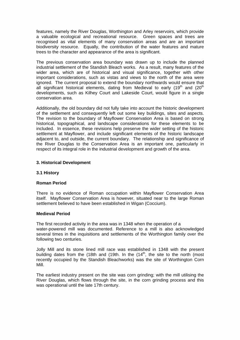
where original windows exist, these are sash windows with small panes in the upper half (woodwork painted white). These include ribbed chimney details, arched brick lintels to the lower and upper floor windows and doors, fan lights, partial tile hung walls to the gable ends, stone sills, terracotta string courses, finials to the bargeboards and decorative diamond brickwork patterns on the gables. The latter being a particular feature which is replicated throughout the new residential development. 6.3 Building Materials and Local Details There are two rows of terrace housing within the conservation area; the cottages known as Lakeside cottages, grade II listed and built of brick with slate roofs. These properties (1-20) have all been rendered in white or cream to the ground floor, with pebble dash to the first floor, built around 1859-1862 (date stones) and in Italianate style.
Image 27: Lakeside Cottages
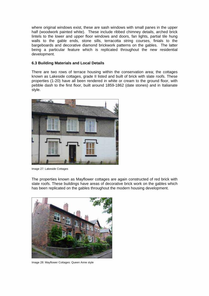
The properties known as Mayflower cottages are again constructed of red brick with slate roofs. These buildings have areas of decorative brick work on the gables which has been replicated on the gables throughout the modern housing development.
Image 28: Mayflower Cottages: Queen Anne style

There is an abundance of interesting brick detailing to be found in the conservation area in the form of corbelling, stringcourses, brick lintels and other intricate features, such as the hoodmold detailing over the windows and doors of Lakeside Cottages. Several of the older properties (Mayflower Cottages) have unusual brick work detailing on the chimney stacks and a distinctive diamond brick pattern on rendered gables, which have a positive impact upon the character and appearance of the conservation area. These features are found on Mayflower Cottages and this symmetry and uniformity creates a cohesive townscape, especially along the terraced rows. Unfortunately, very few of the properties have retained their original windows and doors. Original features are most abundant on the Grade II Listed properties of Lakeside Cottages, with examples of the original sash windows.
Image 29: Architectural details at Lakeside Cottages
Image 30: Italianate architectural style: Lakeside Cottages

Image 31: Window detailing at Lakeside Cottages
6.4 Buildings of Townscape Merit There are currently several listed buildings within Mayflower Conservation Area:
• 1-20 inclusive - Lakeside Cottages, which form part of a group listing – Grade II
This row of former bleach work employee cottages were built for employees of the dye works company and date back to 1859.
Image 32: Lakeside Cottages

Image 33: View of Lakeside Cottages across the Lagoon
Image 34: View of Lakeside Cottages during demolition of the bleach works 6.5 Unlisted buildings of Townscape Merit
1-28 Mayflower Cottages There are 18 properties which comprise Mayflower Cottages. These were constructed in 1894 by the Standish Company Ltd (bleach works). All properties are in the Queen Anne Revival style. The cottages form part of the planned industrial settlement, built by the bleach works company. An essential characteristic of the planned nature of the cottages is the presence of open drying grounds and allotments to the rear of Mayflower Cottages.

Image 35: Mayflower Cottages
Image 36: Mayflower Cottages: architectural details
Image 37: Former Engine House

Image 38: Former Engine House: Front Elevation
Image 39: Former Bleach works wall
Image 40: Former Bleach works Gatehouse

Image 41: Former Bleach works Gatehouse: front elevation
6.5 Public Realm: Floorscape, Street Lighting and Street Furniture Public Realm is defined as comprising of “…the streets, squares, parks, green spaces and other outdoor places that require no key to access them…” (Creating Inspirational Spaces; 2007). Due to the rural nature of the conservation area there is limited public realm present. Street surfaces within the conservation area are varied, with several different surface materials present to varying degrees of repair. The majority of the conservation area has very little public realm, as a large percentage of the area is private woodland and open space, particularly to the rear of Mayflower Cottages. However, the presence of these areas, together with greenbelt beyond, provides an attractive, semi-rural setting for the Conservation Area. Alongside Mayflower and Lakeside cottages the access road is an un-adopted, un-made dirt track and is in relatively poor condition. However, the local residents group (known as Mayflower Cottages Conservation) is currently undertaking work to improve the road surface. Again as a result of being un-adopted there is very little street furniture along this road in terms of street lighting and signs. The majority of public realm within the conservation area is found within the area of the new housing development and includes grassed areas, trees/shrubs and hard-standing parking bays, together with private gardens to the front and rear of properties. Here the predominant paving surface is tarmac and other street furniture (lamp posts, bollards and railings) are a heritage style design and painted black. There are some street trees within the new development and, these, together with other recently planted shrubbery provides soft landscaping in the Conservation Area. 6.6 Historical Association Captain Myles Standish had obvious strong links with Standish and was of the Standish’s of Standish family. As a young soldier, Myles Standish was commissioned to fight in the Netherlands. On his return to England, he was employed by Merchant Adventurers to act as the military captain aboard the ‘Mayflower’ with the Pilgrim Fathers.

7.0 Issues 7.1 Positive 1. A large number of historic properties survive within the conservation area, with the core residential properties dating back to the area’s conception in the 1860s. The majority of the bleach work buildings from the original industrial settlement have been lost and new residential development built in its place, but elements of the former bleach works buildings have been retained and Mayflower provides a good example of a planned industrial settlement quite rare in Wigan. 2. Historic detailing survives on both Lakeside and Mayflower Cottages with stucco and decorative brickwork respectively, the most commonly found features. These all help to create individual character for many of the buildings as well as having a positive impact on the character and appearance of the conservation area. Features such as diaper brickwork are common on the gables, as are label moulds and horizontally sliding sashes.
Image 42: Brick detailing on front gables to Mayflower Cottages
Image 43: Brick detailing to gable ends on new development

Image 44: Brick detailing to rear gables on new development
3. The bleach works site has been subject to several changes over the years, before demolition in 2003. The new residential development has been designed and built in a sympathetic manner and is largely in keeping with the character and appearance of the conservation area, with properties mimicking many of the features and styles of the former industrial buildings and also the existing Mayflower Cottages. Both the former bleach works factor wall, the engine room and the entrance lodge are significant buildings within the settlement and as a result of their prominent location it is important that they continue to have a positive impact on the conservation area. 4. The lake/lagoon has a positive impact on the appearance of the conservation area. This area of open space, with mature planting not only enhances the appearance and setting of Lakeside Cottages but it also creates a pleasant space within the conservation area.
Image 45: Lake/Lagoon towards Worthington Reservoir

Image 46: Lake/Lagoon towards Lakeside/Mayflower Cottages
7.2 Negative 1. There is some poor quality street surfacing, with mismatching materials and poor quality repairs that have a negative impact on the overall appearance of the conservation area. The road surface in front of Mayflower and Lakeside Cottages is unmade and generally of poor quality with an uneven potholed surface. This somewhat detracts from the appearance of the quality buildings within the conservation area and does little to enhance its overall character.
Image 47: Road surface in new development
Image 48: Raised drain covers on pavement
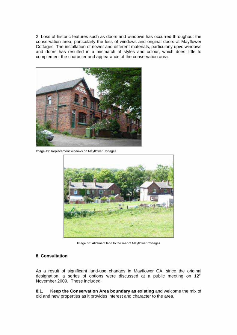
2. Loss of historic features such as doors and windows has occurred throughout the conservation area, particularly the loss of windows and original doors at Mayflower Cottages. The installation of newer and different materials, particularly upvc windows and doors has resulted in a mismatch of styles and colour, which does little to complement the character and appearance of the conservation area.
Image 49: Replacement windows on Mayflower Cottages
Image 50: Allotment land to the rear of Mayflower Cottages 8. Consultation As a result of significant land-use changes in Mayflower CA, since the original designation, a series of options were discussed at a public meeting on 12th November 2009. These included: 8.1. Keep the Conservation Area boundary as existing and welcome the mix of old and new properties as it provides interest and character to the area.

8.2 Impose an Article 4(2) Direction which would remove certain permitted development rights. 8. 3 Extend the Conservation Area boundary to include Worthington and Arley Reservoirs to the north of the existing Conservation Area boundary. This would incorporate historic properties along Chorley Road, to include, Kilhey Court Hotel, Lakeside Nursing Home, South Lodge, Worthington Hall and Worthington Lodge. This had support from the public, but would not give an more significant control over development than current green belt, or historic park and garden policies which already apply. 8. 4 De-designate the Conservation Area. Mayflower Conservation Area has witnessed major new housing development over the past couple of years. Whilst the design of new development reflects the style and form of the former industrial premises, the scale of development may pose questions whether it should be included within the Conservation Area.

Bibliography
Council of the Borough of Wigan: The County Borough of Wigan English Heritage: Guidance on Conservation Area Appraisals (2006) Greater Manchester Sites and Monuments Record (SMR) Pevsner. N & Pollard. R (2006 ed): Buildings of England: Lancashire, Liverpool & the South West Smith. M.D: About Haigh and Aspull Victoria History of the Counties of England, 1911 Victorian Society Wigan Council Unitary Development Plan (2006) Wigan Council Statement of Community Involvement (2006) www.old-maps.co.uk

APPENDIX 1(Maps)


APPENDIX 2: Management Proposals Management Proposal 9. Introduction This section outlines a management proposal for Mayflower Conservation Area. The proposal should be read in conjunction with the respective appraisal for the Conservation Area and also alongside the relevant planning policies from Wigan Unitary Development Plan, EV4A. (see Appendix B for expanded policies). Conservation Area designation is not intended to prevent change, but to influence and manage change to ensure the preservation and enhancement of the Conservation Area. The proposals outlined in this section are intended to: • Preserve the character and appearance of the Conservation Area; • Manage the process of change without compromising the historic environment; and • Consider enhancements to the area. The Unitary Development Plan policies EV3 Design and EV4 Conservation provide guidance to help protect the character and appearance of Conservation Areas, as well as promoting high quality design in any impacting new development. 10. Preservation 10.1 Demolition The Council will seek to preserve the areas listed buildings and buildings deemed to be of local architectural or historic interest in line with policy EV4A, clauses b and c. Any proposals to demolish buildings which make a positive contribution to the character and appearance of the Conservation Area will be carefully examined. Sections 8 and 74 of the Planning (Listed Buildings and Conservation Areas) Act 1990 provide control over the demolition of listed and unlisted buildings within the boundary of a Conservation Area, respectively. Paragraph 4.27 of PPG15, states that proposals to demolish buildings which make a positive contribution to the character and appearance of the area will be assessed against the same criteria as proposals to demolish listed buildings. The existing Conservation Area and the proposed extension contain several listed buildings to which this act applies. There are also several unlisted buildings within the proposed extension to which alteration or demolition would be detrimental as they are regarded as making a positive contribution to the character and appearance of the area. 10.2 Alterations The Council will seek to ensure that any alterations are sympathetic to the architectural character of the building, in terms of colour, proportion, materials and detailing, as well as to the character of the surrounding area. In line with policy EV4A

it will also ensure that the statutory controls over alterations, including enforcement action are appropriately used. Under normal planning controls, certain works are classified as permitted development rights and so do not require planning permission. This includes small scale alterations such as extensions to houses, provision of hard surfaces and the erection of and alterations to boundaries. Within Conservation Areas the range of permitted development rights is limited in order to help ensure the preservation and enhancement of the character and appearance. Therefore many minor alterations do require planning permission, for example; cladding, dormer windows, roof materials, and the installation of satellite dishes. Several of these are noticeable within the current Conservation Area and cumulatively they can have a detrimental impact on the areas character and appearance, and so should be monitored and controlled. 10.3 Article 4 Directions Local planning authorities have the power to remove, or apply for approval to remove permitted development rights, within Conservation Areas, in the form of Article 4 Directions. This would mean that previously permitted alterations would in future be brought under the control of the Council and would require planning permission. The effect of alterations which are acceptable under normal circumstances, such as the replacement of windows and doors are already having a detrimental effect on the historic character and the appearance of the Conservation Area. These changes are widespread within the Conservation Area and further alterations of this nature will have a serious affect on the special architectural quality of the area, which is significant in its designation as a Conservation Area. The Council will consider imposing an Article 4 Direction within Mayflower Conservation Area, removing certain permitted development rights and thus preventing further erosion of the historic and architectural character of the area. This will be undertaken in 2010. 11. Enhancement 11.1 Trees Trees play a significant role in creating the character and appearance of the Conservation Area and many within Mayflower are already subject to Tree Preservation Orders (T.P.O.s). Every effort should be made to provide new and replacement trees within any proposed new development or within areas where trees are dying or damaged. The semi-rural character of the area presents little need for additional tree planting or landscaping other than in private spaces, as much is already naturally well established, particularly to the east of the Conservation Area. New areas of landscaping and green spaces have been created as part of the new residential development, together with tree planting. However, continued maintenance of existing areas, such as the area of woodland to the rear of Mayflower Cottages and Red Rock Lane, and the mature trees to the front of Mayflower Cottages should be considered and promoted.

11.2 Open Spaces The abundance of open space and greenery is another important feature found within the Conservation Area. Any future development proposal must ensure its survival and be sympathetic to the character of the area. Within the village, there are few opportunities for new development however, if proposed care must be taken to ensure high quality design which is sympathetic to the surrounding area. 11.3 Reinstatement of Architectural Features Many of the buildings within Mayflower Conservation Area have lost their original doors, windows and other architectural features over time. As a result, their architectural character has been eroded and this has a detrimental effect on the character of the wider area. Should proposals for alterations come forward there may be opportunities to encourage the reinstatement of these features. However, as a further measure to encourage reinstatement or repair of original features, it is recommended that the Council consider sources of financial support, which may be available for such works. 11.4 Public Realm and Street Furniture An honest and robust approach should be taken in the selection of new street furniture to avoid the creation of stereotypically ‘heritage’ installations. Any additions must be justified and restricted to essential items. The siting of new features in the public realm must be afforded careful considerations in regards to views, vistas, and the setting of buildings; particularly those identified as making a positive contribution to the townscape. The Council should seek to remove any existing street furniture which is either unsightly or un-necessary within the Conservation Area. 12. Monitoring and Reviewing This document should be reviewed every five years in the light of the Local Development Framework, and other emerging government policy. A review should include the following: • A survey of the Conservation Area; • A photographic record of the Conservation Area; • An assessment of whether the various recommendations detailed in this document have been acted upon, including proposed enhancements; • A building condition survey; • The production of a short report detailing the findings of the survey and any necessary action.

APPENDIX 3: Unitary Development Plan Policies
EV3 DESIGN The council is committed to the achievement of good design in all development. The design qualities and standards will be key considerations in judging proposals with the aim of creating places and spaces which are attractive, accessible, safe, uncluttered and which take into account public health, crime prevention, community safety, sustainability principles and heritage conservation. The quality of the built environment in the Borough is crucial to its success as a place to live, work and play. Well designed buildings, streets and neighbourhoods can help promote sustainable development, attract businesses and investment and reinforce civic pride and sense of place. All applications from the smallest extension to major development schemes will be expected to achieve high standards of design. EV3A DESIGN OF NEW DEVELOPMENT All proposals for development will be required, through their design, to promote where relevant: (a) The character and identity of place through responding to and
reinforcing locally distinctive patterns of development, spaces, natural topography, landscape and materials;
(b) The continuity of street frontages and the enclosure of space by development which clearly defines private and public areas and takes into account the microclimatic conditions;
(c) Public spaces and routes that are attractive, safe, visually and physically uncluttered and function effectively for all in society;
(d) An environment that is inclusive and accessible for all, making places that connect physically and visually with each other and are easy to move through, putting people before traffic;
(e) Legibility through development that provides recognisable routes, Intersections, and protects and enhances both local and strategic views of landmarks and focal points in order to help people ‘visually navigate’;
(f) Adaptability through development that can respond to changing social, technological and economic conditions;
(g) Diversity and choice through a mix of compatible developments and uses that work together to create viable places that respond to local needs;
(h) Appropriate scale of development that reflects and enhances the Buildings, and roofs, scale, massing, heights and densities that are specific to that locality and which take into considerations the human scale relationship with the buildings themselves;
(i) Sustainability principles including, wherever possible, reducing the impacts on climate change; the efficient use of energy and water; the

use of sustainable drainage systems wherever possible, innovation in building design; reducing the use of primary minerals; and reusing and recycling buildings and materials.
The importance of good design is increasingly being recognised for its contribution to urban regenerations as well as its value in its own right. In line with this policy the council will expect applicants for planning permission to demonstrate how they have taken account of the need for good design in their development proposals. The policy provides clear guidance on the objectives and key principles of design and is consistent both with the approach to design in PPG1 and that put forward in “By design. Urban Design in the planning system: towards better practice”, published by the government. EV3B ADVERTISEMENTS The display of advertisements will be controlled to ensure that they do not adversely affect the character of the buildings, the amenity of the area or public safety. Although the council recognises that outdoor advertising has a useful role to play in the commercial life of the borough and the appearance of the built environment, it is important to avoid gaudy, unsightly clutter of signs which obscure the detail of buildings and destroy the human scale of urban spaces. The council wishes to raise the general standards of advertisement display throughout the borough by the application of principles and guidelines specified in its approved Design Guide for Advertisements. Particular care will be taken over advertisements in conservation areas and which affect listed buildings or buildings of local interest in line with the provisions of policies EV4A, EV4B and EV4C. EV3C DESIGN OF FRONTAGES TO SHOPS/COMMERCIAL PROPERTIES In addition to meeting the requirements of EV3A, proposals for new frontages or alterations to shops and commercial properties will be required to: (a) Use materials and a design in sympathy with the whole façade of the
building or, where more appropriate, satisfactory surrounding premises; (b) Have display windows at ground level unless they would be
inappropriate to the design of the whole façade; (c) Avoid using external security measure where the choice of design and
colour would have an adverse effect on the appearance and character of the shop front, building, street and wider context. The choice of appropriate security measures must aim to maximise transparency opportunities in order to increase natural surveillance and reduce uninviting dead frontages;
(d) Provide level or ramped access into the building wherever possible. The quality of the street scene in town and district centres is strongly influenced by the quality, design and materials of shop and commercial building frontages. This policy aims to control these aspects of town centre design by specifying the requirements which such frontages must meet. The council has also produced a Shop Front Guide which provides supplementary planning guidance to promote good design in shop and commercial frontages. Particular care will be taken over the design of frontages in conservation areas and which will affect listed buildings or buildings of local interest in line with the provisions of policies EV4A, EV4B and

EV4C. EV3D LANDSCAPING OF DEVELOPMENT Development will be required to incorporate good quality hard and soft landscaping as an integral part of the proposals to enhance the environment and setting of a new building and help integrate the development into its surroundings. The including of landscaping in development schemes can usefully provide screening, softening, colour, texture and seasonal variations and can break up large wall or parking areas. Hard landscaping can also be effective in introducing attractive textures, colours, patterns and sculptural features into floor areas and should be designed to incorporate crime prevention considerations. Only in exceptional circumstances will it be considered appropriate to dispense with a landscaping scheme in the submission for new development. EV4 CONSERVATION The council will conserve the historic built environment by: (1) Not permitting proposals which would harm the character or
appearance of a listed building or their settings, or proposals which fail to preserve or enhance the character or appearance of a conservation area;
(2) Protecting and enhancing the character and appearance of ancient monuments, sites, buildings and structures of archaeological interest and historic landscapes;
(3) Exercising its normal development control powers to encourage the protection and enhancement of buildings of local interest;
(4) Encouraging the occupation of old buildings and permitting new uses which are compatible with their character and setting;
(5) Carrying out environmental improvement schemes in conservation areas;
(6) Designating new conservation areas and reviewing the boundaries of existing ones where the quality and interest of the area is of special architectural or historic interest due to:
� The historic layout of the properties, boundaries and thoroughfares; � The particular mix of uses; � The use of characteristic materials; � The appropriate scaling and detailing of buildings; � The quality of advertisements, shop fronts, street furniture and hard
and soft surfaces; � The quality of vistas along streets and between buildings; o � The extent to which traffic intrudes and limits pedestrian use of
space between buildings. The conservation of the best of the built environment forms a major component in enhancing and protecting the heritage of the borough. This is not only a matter of protecting and enhancing historic buildings themselves but also their settings. Such an approach can only be if new uses can be found for old buildings so as to provide funding for their preservation and restoration and by sensitive control over all aspects of design.

The use of reclaimed materials in restoring buildings will usually make economic sense as well as helping to minimise the use of primary minerals. Further areas will also be considered for designation as conservation areas and the boundaries of existing conservation areas will be reviewed by consideration against the broad criteria listed in clause (6) of the policy. EV4 DEVELOPMENT & DESIGN IN CONSERVATION AREAS In addition to other development and design policies which apply throughout the borough, the following considerations will be applied within conservation areas and their settings: (a) The council will ensure that any proposals for development within a
conservation area will preserve or enhance and will not harm the character or appearance of that area;
(b) The demolition or inappropriate alteration of buildings which make a positive contribution to the historical, architectural or industrial archaeological character or appearance of a conservation area will not be permitted;
(c) Consent for demolition will only be granted subject to the building not being demolished before a contract for carrying out the redevelopment of the site to a high standard of design is made for which planning permission has been granted or some other legally binding commitment has been made;
(d) Proposals with include the demolition of significant features including porches, chimneys and boundary walls/railings or which remove or alter architectural features of value will not be permitted. The retention or, where features are missing, restoration or where inappropriate forms or features are present, the remodelling of the external character of the buildings, particularly with regard to windows, roofs, materials and
advertising will be required; (e) Signs should preserve or enhance the character or appearance of the
conservation area and its setting and will be permitted provided they meet the following criteria:
(i) Facia signs should, particularly in terms of size, proportions, degree of the style and size of lettering, be in keeping with the character of the shop front, fascia details and materials, the building as a whole and the area. If they are to be illuminated they should be externally illuminated using unobtrusive and discreet light fittings or take the form of individually illuminated and individually affixed letters;
(ii) The cumulative impact of advertisements should not detract from the character or appearance of the building or locality. Advertisement structures should not be superimposed on other advertisement structures;
(iii) Projecting or hanging signs should be of small size, thin section and if illuminated, should be discreetly externally illuminated and located at fascia level.
(f) The council will encourage the preservation and, where necessary, the sensitive relocation of attractive items of street furniture and will encourage the preservation and, where possible, the enhancement and extension of stone sett and flag surfaces. Where works are undertaken to these and other special surfaces, such as paviors, temporary or permanent reinstatement should be in the original fabric;
(g) The council will encourage the removal of buildings detrimental to the character of conservation areas;

(h) The rendering or cladding of stone and brick buildings will not be permitted;
(i) Proposals which involve development, including relatively large-scale extensions, within the grounds/gardens of dwellings and other buildings such as churched where the grounds contribute to the character of the conservation area will not be allowed.
There are currently 23 conservation areas in the borough which represents a major part of its historical and architectural heritage. This policy details the main considerations that the council will apply when addressing development proposals within them or within other conservation areas which may be designated in the future. Buildings which are considered to make a positive contribution to the character of the conservation area include those with some defects such as inappropriate window frames, advertisements or shop fronts or which are in need of repair. Any development of such premises will be expected to include suitable repairs and the replacement of inappropriate features with more sympathetic ones. Advertisements can have a dramatic impact on the appearance of a conservation area. Well designed signage can be both sensitive and visually interesting in relation to the character and appearance of such areas whilst being commercially effective. It is important however, that signs are not too prominent or dominant and that they do not cover up high quality materials such as brickwork, stone, tiles or polished finishes which are integral to the building. Signs should also not cover up, obscure, detract from or damage architectural features of the buildings, or fascia area and their size, proportions of the upper façade and fenestration pattern. Standardised solutions such as the use of illuminated boxes or box-like structures are unlikely to be acceptable. For certain building types such as public houses a location for hanging signs above fascia level may be justifiable in relation to traditional practice in the area. EV4B LISTED BUILDINGS The council will encourage the protection and where possible appropriate maintenance of buildings of special architectural or historic interest and their settings. In particular, it will: (a) Not permit the demolition of listed buildings or significant parts of them unless a convincing case for demolition has been made out and the council is satisfied that all possible means of retaining the building have been exhausted; (b) Ensure that proposals affecting internal and external alterations,
extensions and other development proposals affecting listed buildings or their settings will not be permitted unless they are in keeping with the buildings character;
(c) Permit appropriate alternative uses for listed buildings to ensure their preservation and which would not adversely affect their architectural character or setting;
(d) Secure proper preservation of occupied and unoccupied listed buildings to prevent their falling derelict where further deterioration would irreversibly affect their long term futures;
(e) Require the replacement of inappropriate features, materials or sections as part of any scheme involving change of use of listed buildings.
This policy details the main considerations that the council will apply when assessing development proposals to or affecting buildings included in the list of buildings of

special architectural or historic interest in the borough. It may be necessary to relax the strict interpretation of other policies of the plan, for example Greenbelt policy, in order to ensure the survival of particularly important buildings or to ensure that extensions are in scale and character with a listed building. EV4C BUILDINGS & STRUCTURES OF LOCAL ARCHITECTURAL OR HISTORIC INTEREST The council will encourage the protection and enhancement of building and structures of local architectural or historic interest and their settings. Development schemes including alterations, changes of use and advertisements will be expected, wherever practicable, to respect their character and retain or restore their original historic features, materials and form. There is a whole range of buildings and structures in the borough which form a significant part of the familiar and cherished local scene. Further extensions of the list of Buildings and Structures of Local Architectural or Historic Interest will be published as supplementary planning guidance and incorporated into the plan at review. The relative weight to be given to the content of an adopted development plan and of supplementary planning guidance is set out in PPG12. These buildings, whilst not currently justifying inclusion on the statutory list, do possess local historic or architectural merit, are a major part of the borough’s historic environment, its day to day history and are a rich source of local identity, memory and distinctiveness. Although the council does not have the same detailed control over proposals to these buildings and structures as it has over listed buildings, it will exercise its normal development control powers to preserve and enhance the buildings. However, sensitive and well designed alterations or extensions will be permitted, particularly if they help to ensure a buildings continued occupation. The council will also consider, in appropriate cases, exercising the power available to it under Section 3 of the Planning (Listed Buildings and Conservation Areas) Act 1990 to serve Building Preservation Notices in respect of buildings which are not listed, but which it considers to be of special architectural or historic interest and which are in danger of demolition or alteration in such as way as to affect their character. EV4D HISTORIC PARKS, GARDEN & CEMETERIES Permission will not be given to any proposal which is likely to adversely affect the character or setting of any of the following historic parks, gardens or cemeteries:- 1. Haigh Hall grounds, Haighlands, Moat House and Haigh House gardens,
Haigh; 2. Standish Hall remnant parkland and Ashfield House gardens, Standish; 3. Kilhey Court grounds, Worthington; 4. Bispham Hall and Winstanley Hall Parks, Billinge; 5. Golborne Hall Park, Golborne; 6. Hindley Hall Park, Aspull; 7. Atherton Hall Park, Atherton; 8. Astley Hospital, (former) Astley Vicarage and the Meads, Tyldesley; 9. Hindley, Atherton, Ince, Tyldesley and Leigh Cemeteries; 10. Historic public Parks and Mesnes Park, Wigan and Lilford Park and Firs
Park, Leigh;

11. Other historic parks and gardens which may from time to time be indentified.
These areas are those where a landscape of particular historic interest remains and where special protection is needed to ensure their survival. Such designation would not necessarily preclude development but would certainly require that particular consideration be given to the amount and design of any development which may be allowed. Similarly, there may be some proposals which would involve only change of use of the land without any building development but which could be unacceptable by virtue of the impact on the landscape. The council will apply the terms of this policy to other historic parks and gardens which may from time to time be identified only after these have been listed in supplementary planning guidance which has been adopted in accordance with the advice of PPG12. This supplementary planning guidance will be incorporated in the development plan at the next review. The relative weight given to the content of an adopted development plan and of supplementary planning guidance is set out in PPG12. EV4E ARCHAEOLOGY, ANCIENT MONUMENTS & DEVELOPMENT The council will protect and enhance the character and appearance of sites, buildings and structures of archaeological interest and Ancient Monuments. In particular, it will not allow development proposals which fail to:
(a) Enhance and preserve in situ scheduled or unscheduled Ancient
Monuments of national importance and, in appropriate circumstances, significant unscheduled monuments of more local importance or which fail to adequately protect the setting of such monuments;
(b) Incorporate an approved scheme of archaeological investigation (including, where appropriate, excavation, recording and salvage work prior to development with subsequent analysis and publication of results), if necessary, with funding by the developer, in cases where destruction or removal of any ancient monument or archaeological remains, known or believed likely to exist, is considered acceptable by the council. Conditions may be imposed requiring such investigations as part of the planning permission.
Where fresh archaeological discoveries of significant importance are made during development, the council will seek to ensure their preservation. The importance of Ancient Monuments and archaeological sites means that proposals which may affect them are carefully vetted to ensure that they do not damage such sites. In certain cases it may be possible for an applicant to demonstrate that particular archaeological sites and monuments will be satisfactorily preserved either in situ or by record (i.e. adequately investigated and the results reported). Preservation by record is regarded as a less satisfactory option. Despite government advice, it is not considered appropriate to specify all the areas and sites to which this policy applies on the proposals map. The lack of information on many archaeological sites as well as the impracticality of plotting the multitude of sites on the proposals map rules out such an approach. However, the sites and monuments record (SMR) for the borough forms the basic source of up-to-date information to identify such sites and areas. It is kept within the planning and development department and performs the function of supplementary planning guidance. The relative weight to be given to the content of an adopted development plan, supplementary planning guidance which has been prepared in the proper manner and to other material considerations is set out in PPG12. The advice and

assistance of the Greater Manchester Archaeology Unit will be sought in assessing planning applications for development affecting ancient monuments and archaeological sites. Implications of Conservation Area Status Conservation area status is not intended to stifle new development nor preserve areas as museum pieces. Conservation areas will be allowed to evolve to meet changing demands although the council when taking development control decisions will take extra care to ensure that the special architectural and historical qualities are not eroded. The normal requirements for planning permission and building regulation approval apply with some additional restrictions. • Planning applications will be carefully considered by the council to ensure that they enhance or preserve the special character of the area. • The impact of any development outside the boundary of the conservation area, which might affect its setting and character, will also be carefully considered. • Conservation Area Consent is required for the demolition of most buildings or structures. • The council must be given 6 weeks notice of any intention to undertake works to cut down, lop, prune or uproot any trees over a certain size in the conservation area. • In order to be able to consider the implications of development proposals, the council will normally require proposals within the conservation area to be submitted in the form of a full, and not outline, application. In addition, works, which, elsewhere are classified as permitted development in the Town and Country Planning (General Permitted Development) Order 1995 may require planning consent. Developers are advised to check with the council at an early stage on the need for required permissions. Unauthorised works can lead to prosecution and the council may take enforcement action requiring the works to be ‘undone’.

Glossary of Terms (from Neil Grieves ‘Conservation Glossary’) Bargeboards Boards fixed at the gable ends of roofs to conceal and protect the ends of the roof timbers, or thatch. They may project over the wall face and are frequently highly decorative, estates often adopted their own personal style. Pattern books were available. The barge is the overhanging edge of a roof up the slope of a gable. Conservation Areas An area designated by a local authority as an area of special architectural or historic interest, the character of which it is desirable to preserve or enhance. Since the power was first vested in local authorities under the Civic Amenities Act of 1967, some 8000 areas have been designated throughout Britain, and the range is enormous, from busy city centers to small villages and from industrial to residential areas, with a great deal in between. While the respective Secretary of States have the power, in exceptional cases to designate areas, unlike listing, designation remains a matter for the discretion of individual local authorities. Eaves The lower edge of a sloping roof, where it overhangs the wall head. Finial The topmost featured ornament, freestanding above spire gable etc Gable The vertical part of the end wall of a building contained within the roof slope, usually triangular but can be any "roof" shape Hoodmould Projecting molding over an arch or lintel designed to throw off water, also known as dripstones. They could be quite ornate and many estates adopted particular styles for their buildings. Listed Building: A building included on a list of buildings of architectural or historic interest, compiled by the secretary of state. Listing covers any structure or erection or any part of a building, or any building or structure falling within the curtilage of a listed building and dating prior to 1948. Listed buildings are divided into three categories, I, II*,II in England. Lintel A horizontal beam bridging an opening in a wall. In traditional stone construction, a stone lintel was used on the outer leaf of a wall with a "timber safe lintel" on the inner leaf. The timber lintel could span further than stone and was capable of absorbing movement, while the stone lintel was more resilient to the effects of the elements.

Render A term used to describe any durable, protective coating applied to an external wall. Renders are not intended to be decorative as such, and should not be confused with plasters such as stucco which are applied with the intention of imitating stone. Sash window A glazed frame, can be sliding or side hung. Sill Horizontal member at the base of a window opening or door frame, usually projecting to throw water from the face of the building. Stone Aprons A raised panel below a window-sill, sometimes shaped and decorated Stringcourse A shallow moulding continued across a whole facade which may be defined by its position e.g. sill or impost course. Stucco Originally an Italian plaster composed of gypsum, lime and some powdered marble. Slow setting and therefore easy to work, it sets very hard. During the 18th century, improvements were made to the mixture to allow it to be used on the exterior of buildings, latterly in imitation of stone.

APPENDIX 4: Consultation In accordance with Part 6, Section 24(4) and Part 6, Section 36 of the Town and Country (Local Development) (England) Act 2004, Wigan Council adopted its Statement of Community Involvement on the 12 July 2006. This statement sets out the council’s policies for involving the community in the wider planning processes, including the preparation of the Local Development Framework and Conservation Area Appraisals. It provides advice as to how and when communities and interested stakeholders can become involved in the planning process. In line with this statement when undertaking this assessment of Mayflower, the local community and interested stakeholders including elected members were asked to contribute their thoughts, opinions and suggestions regarding the current conservation area and draft report. The preparation of the Conservation Area Appraisal has been subject to public participation and involvement of the local community. A strong community spirit exists in Mayflower and an active residents group has been in place for some time. The Draft Mayflower Conservation Area Appraisal was subject to targeted consultations with all property occupiers and key stakeholders during a 6 week period from 3rd August 2009. All occupiers were notified of the proposal to extend the Conservation Area boundary to the north and provided with a copy of a summary document and a comments sheet. The full draft appraisal was available on the Council’s web site for downloading. In total, 5 responses were received and these, along with Wigan Council's response are noted below A public meeting took place on 12th November 2009 to discuss the appraisal document and gather public feeling. The general consensus was to agree the extension to the conservation area boundary, reflecting public feeling and opinion via the previous consultation: Name of Consultee Summary of Comments Response and action Mr and Mrs Unsworth V Stevens
• Restrictions on
extensions to retain character
• Retain and protect land to rear of Mayflower Cottages
• Retention of Mayflower as a Conservation Area
• Extension of Conservation Area to include Arley Hall
• Revise the Conservation Area
. • The Conservation
Area will be protected from adverse and inappropriate development through UDP policy ENV4/ENV4A.
• After consultation,
it was decided that the new build will remain in the Conservation Area as all properties are covered by a Management

M Halsall Mr A Aspey
boundary to exclude the new development on the former bleach works site
• Retain Mayflower Conservation Area
• No guidance on Conservation Area do’s and don’ts
• Retain Mayflower Conservation Area
• Grants for properties, especially for sliding sash windows
• Request for improved road surface to the front of Lakeside and Mayflower Cottages (cobbles), together with installation of street lighting.
Agreement which requests that external features and finishes are retained.
• The Conservation Area will be protected from adverse and inappropriate development through UDP policy ENV4/ENV4A.
• There is a general leaflet on Conservation Areas and Listed Buildings. A more specific one relating to Mayflower Conservation Area will be produced in due course.
• The Conservation
Area will be protected from adverse and inappropriate development through UDP policy ENV4/ENV4A.
• There are no grants available from the Council at present for property improvements
• The Council will look into potential for re-surfacing the un-made road and

Lea Nixon
• Retain Mayflower Conservation Area.
• Limit change to properties in the Conservation Area
installation of street lighting
• Changes to the
new build are limited by a Management Agreement, which effectively removes PD rights.
• Impose an Article 4 Direction on Mayflower Cottages

Useful Information Conservation Officer Civic Buildings New Market Street Wigan, WN1 1RP T: 01942 404253 E: [email protected] English Heritage Customer Services Department PO Box 569 Swindon, SN2 2YP T: 0870 3331181 E: [email protected] Greater Manchester Archaeology Unit University of Manchester Oxford Road Manchester, M13 9PL T: 0161 2752314 Township Manager Neighbourhoods Unity House Sovereign Road Depot Westwood Park Drive Wilton Street Wigan Wigan WN3 4HE WN1 3AE T: 01942 486773 T: 01942 244991 E: [email protected]