master thesis - vbn.aau.dk€¦ · web viewthe people have been compelled to opt for vertical...
TRANSCRIPT

Is Community Governance Working?
Local Governance of Common Property Resources in Three Agro-climatic
Regions in Rajasthan, India
A case study of community management in the Arid, Semi-Arid and dry Semi-arid
regions of Rajasthan.
By: Henrik Daniel Rasmussen
Supervisor: Mammo Muchie
Aalborg
June 29th 2012
1
MASTER THESIS
Table of Contents
IS COMMUNITY GOVERNANCE WORKING?........................................................................................ 1
1.0 SYNOPSIS......................................................................................................................................... 5
2.0 INTRODUCTION:........................................................................................................................... 6
2.1 Problem Formulation...................................................................................................................................... 9
2.1.1 Description of Problem formulation...............................................................................................................9
3.0 OPERATIONALIZATION............................................................................................................ 10
3.1 Design........................................................................................................................................................... 10
3.2 Use of theory................................................................................................................................................ 11
3.3 Method......................................................................................................................................................... 12
4.0 THEORY......................................................................................................................................... 17
4.1 Garrett Hardin - Tragedy of the Commons:....................................................................................................18
4.2 Elinor Ostrom - Governing the Commons:...................................................................................................... 25
5.0 INTRODUCTION OF CASES....................................................................................................... 30
5.1 Case Descriptions.......................................................................................................................................... 34
5.1.1 Case I: Udaipur District.................................................................................................................................34
5.1.1.1 Ramaj..................................................................................................................................................36
5.1.1.2 Ramaj Conclusion:...............................................................................................................................44
5.1.1.3 Dodawali.............................................................................................................................................47
5.1.1.4 Dodawali conclusion:..........................................................................................................................53
5.1.2 Udaipur District Conclusion..........................................................................................................................55
2
5.1.3 Case II - Jaisalmer District.............................................................................................................................56
5.1.3.5 Bhopa..................................................................................................................................................58
5.1.3.6 Bhopa Conclusion................................................................................................................................67
5.1.3.7 Rasla....................................................................................................................................................68
5.1.3.8 Rasla Conclusion.................................................................................................................................74
5.1.4 Jaisalmer District Conclusion........................................................................................................................75
5.1.5 Case III - Alwar District..................................................................................................................................76
5.1.5.9 Bakhtpura (periphery of Sariska Tiger Reserve):.................................................................................80
5.1.5.10 Bakhtpura Conclusion.........................................................................................................................85
5.1.5.11 Kalikhol (Buffer-zone of Sariska Tiger Reserve):..................................................................................86
5.1.5.12 Kalikhol conclusion..............................................................................................................................90
5.1.5.13 Kairwari (outside Sariska Tiger Reserve):............................................................................................91
5.1.5.14 Kairwari Conclusion.............................................................................................................................93
5.1.6 Alwar District Conclusion..............................................................................................................................94
6.0 CONCLUSION................................................................................................................................ 95
7.0 REFERENCES................................................................................................................................ 98
8.0 APPENDIX.................................................................................................................................. 102
8.1 Appendix I: Description of Terms................................................................................................................. 102
8.2 Appendix II: Ramaj Details........................................................................................................................... 105
8.3 Appendix III: Dodawali Details..................................................................................................................... 106
8.4 Appendix IV: Alwar Village Details............................................................................................................... 107
3

1.0 Synopsis
This thesis investigates community management of Common Property Resources in three Agro-
climatic regions in Rajasthan. The focus of the thesis is to investigate the local management
practises in relation to Garrett Hardin’s Tragedy of the Commons and Elinor Ostrom’s Governing
the Commons. The data has been collected through five months of field work in Rajasthan and in
cooperation with an Indian, Rajasthan based NGO.
The data and the following analysis are based on a questionnaire conducted in seven different
villages as well as walks in the land areas to estimate the status of encroachment and vegetation.
This has been done within three different agro-climatic regions in order to obtain information on
management practises under different conditions such as cultural, climatic, social-economic and
environmental issues.
4

“What are the roots that clutch, what branches growOut of this stony rubbish? Son of man,
You cannot say, or guess, for you know onlyA heap of broken images, where the sun beats,
And the dead tree gives no shelter, the cricket no relief,And the dry stone no sound of water. Only
There is shadow under the red rock,(Come in under the shadow of this red rock),
And I will show you something different from eitherYour shadow at morning striding behind you
Or your shadow at evening rising to meet you;I will show you fear in a handful of dust”.
“The Waste Land” T.S. Eliot
2.0 Introduction:
The Indian economy has since the mid 90´s been through a rapid growth. In 1994-1995 the GDP
was 7.5%, and since early 2000 the economy has been growing with around 9% annually1. The
Indian economy is therefore one of the leading economies of the BRICS2 countries, being the fastest
growing and the largest emerging market economy.
It is ,however, not everyone in India who has benefited from the economic boom. Overall, the
economic growth has been localized to the major cities3. This uneven development is further
enhanced by the fact that there is a rural population of 742.490.639 and an urban population of
286.119.689 in India4. Arid regions, tribal areas and the inaccessible hill/mountain regions have
largely remained outside the growth paradigm5. The crisis in these regions has been apparent in
terms of reduced land and livestock holdings, a breakdown in agro-pastoral production systems,
changes in cropping patterns and depleting groundwater tables6.
The agrarian development, based on resource intensification and capital investment for increased
production, also known as the green revolution, has spiked and levelled in many parts of rural
India7. The passing of the Mahatma Gandhi National Rural Employment Guarantee Act, The Forest
1 http://www.mapsofindia.com/india-economy.html 2 Brazil, Russia, India, China South Africa3 A Common Story – In the Rain Shadow of Green Revolution, Foundation for Ecological security, 20104 http://www.censusindia.gov.in5 A Common Story – In the Rain Shadow of Green Revolution, Foundation for Ecological security, 20106 A Common Story – In the Rain Shadow of Green Revolution, Foundation for Ecological security, 20107 A Common Story – In the Rain Shadow of Green Revolution, Foundation for Ecological security, 2010
5

Right Act and the National Food Security Act are some indicators of this crisis in rural employment
and sustainability8. India has the largest number of poor in the world; many of them depend directly
or indirectly on natural resources for their livelihoods. Poverty, as well as large and expanding
human and livestock populations, puts unrelenting pressure on these resources9.
The close connection of the rural poor to the natural resources and the traditional user rights, of
community forest, -Pasture lands and Revenue Wasteland, the resources are viewed as Common
Property Resources or Common Pool Resources10 (CPR). In Rajasthan there is a significant issue
with encroachments on the communities CPRs, this is partly due to the population pressure and the
increased resource demand but also the Government policy of regularization of the encroached
lands. There is, so to speak, an integrated benefit on trespassing on community lands. The irony is
that while trespassers are rewarded through regularization; law-abiding people are deprived through
loss of access to the commons11.
Today, approximately 22% of India´s land area is under forest, with around 275 million rural poor
depending on it for their livelihood12. Half of India´s 89 million tribal people, one of the most
disadvantage social groups in India, live in the periphery of the forest areas and have a close
cultural and economic link to the forest13. However, the quality of these forests has been
significantly reduced since Independence in 1947. Although, there has been a large increase in the
forest land under control by the Forest Department (a 50% increase from 1960 to 1980), there has
been a steady degeneration of these government managed forests14. An estimate by the World Bank
states that 41% of the forest lands have been degraded over the last several decades15.
8 A Common Story – In the Rain Shadow of Green Revolution, Foundation for Ecological security, 20109 India - Alleviating poverty through forest development, World Bank, 200010 CPRs are land resources managed by a local community, rather than controlled by governments, or owned by individuals. "Rural common property resources are broadly defined as, resources towards which all members of an identifiable community have inalienable user rights. In the Indian context CPRs include Community Pastures, Community Forests, Government Wastelands, Common Dumping and Threshing Grounds, Watershed Drainages, Village Ponds and Rivers etc. The first three resources are particularly important because of their large area and their contribution to people's sustenance. (Jodha)11 Decolonizing the Commons, S.N. Bhise; 200412 India Unlocking Opportunities for Forest-Dependent People in India, World Bank, 200513 India Unlocking Opportunities for Forest-Dependent People in India, World Bank, 200514 Conservation Through Cultural Survival: Indigenous Peoples And Protected Areas, Stevens; De Lacy, 199715 India Unlocking Opportunities for Forest-Dependent People in India, World Bank, 2005
6
India´s forest are ecological unstable and unhealthy. The process of conversion
largely through clear cutting has destroyed the primary structure of most of the
forests. Repeated fires and overgrazing have altered the ground and soil structure
substantially. Status of Indian Forestry, S.A. Shah, 1995.

One of the reasons for this decay of Natural Resources in India after 1947 is that large parts of the
Jungle were turned into state forest or revenue forest, mainly for commercial timber production,
with little regard for the development of the forest communities16. In this process, rural people and
tribes, who had lived and used the forest as a significant part of their livelihood, were denied user
rights to the land through changing laws and Acts17,18. In the early 1980´s there was a shift towards
forest conservation, with the passing of the Forest Conservation Act19. During the late 80´s West
Bengal and other progressive states, experimented with allocating a specific area of forest along
with limited management responsibilities to communities in return for a share of forest revenues
from timber and better access to non-timber forest products20. In 1990 a policy circular formally
adopted this model as Joint Forest Management (JFM).
After independence, on one hand, access of communities to common lands was legally denied by
the state, on the other hand the derelict state functionaries continued illegally to provide access to its
individuals. This has led to widespread, illegal privatization of most of the common land in the
villages21. The people have been compelled to opt for vertical ties with their patrons at the cost of
community solidarity and social cohesion. It became nearly impossible to put in place the
institutional mechanisms for sustainable land use leading to large-scale deprivation and land
degradation leading to economic, social and political disempowerment of the rural poor dependent
on the commons22,23,24.
Through my nine months with Seva Mandir, an Indian, Rajasthan based NGO, I have worked
exclusively with JFM for four months (Sept.-Dec. 2010) and the general status of CPRs in
Rajasthan for five months (Sept.-Feb 2011-12). During this time I have estimated the status of 28
JFM sites in Udaipur district alone and conducted field trips all over Rajasthan to evaluate the status
of village CPRs. Through this work I have seen both success and failures in the management of the
16 India Unlocking Opportunities for Forest-Dependent People in India, World Bank, 200517 Decolonizing the Commons, S.N. Bhise; 200418 Conservation Through Cultural Survival: Indigenous Peoples And Protected Areas, Stevens; De Lacy, 199719 India Unlocking Opportunities for Forest-Dependent People in India, World Bank, 200520 India Unlocking Opportunities for Forest-Dependent People in India, World Bank, 200521 Tribal Land Rights in India, C.Ashokvardhan, Center for Rural Studies, Mussoorie, 200622 Tribal Land Rights in India, C.Ashokvardhan, Center for Rural Studies, Mussoorie, 200623 The Waste Land, Nandita Roy, 200324 Decolonizing the Commons, S.N. Bhise; 2004
7

CPRs. I have seen completely ruined land areas without a single tree left due to overexploitation, I
have spoken to villagers who are conducting minor wars with neighbouring villages over the access
to the natural resources; often with lethal consequences on both sides, as well as villages who are in
open conflict with the Forest Department, due to denied access to the local forest. But I have also
seen successful management of the natural resources by the communities and well functioning local
institutions that are able to resolve, often long-term and violent conflicts through community based
organizations and conduct successful development work on their local CPRs, both in terms of
restoring the vegetation and strengthening the local institutions. This has led me to the question of
this thesis:
2.1 Problem Formulation
How is the local governance determining the success or failure of the CPRs in three agro-climatic
regions in Rajasthan, India?
2.1.1 Description of Problem formulation
The hypothesis of this thesis is; a CPR, sustainably managed and used, can provide the community
with a self-empowering tool for improving the natural resources, on which they are dependant.
Furthermore, a sustainable managed CPR will provide direct and indirect benefits in terms of
increased use values and more tangible ecological benefits. Additionally, this will positively affect
the general development of the community in the form of spill-over effects such as; efforts to build
a school or to resolve conflicts. It could also prove a powerful tool in mitigating the severe
degradation of the natural resources in India and turn this progress with the sustainable community
management of CPR.
Governance or management programs applied to the CPR, being it Community Pastures,
Community Forests or Government Wastelands, are a result of human decision-making and actions
and therefore the local population as well as external powers, such as government, NGO´s and/or
international institutions, must be considered an integral part of the equation. Management implies
control, whether being informed of economic and/or ecological processes or not. Decisions are
made on the basis of goals or objectives in relation to a hierarchy of wants, either for the individual
household or for the community, and based on the perception of external and internal processes25.
25 Sustainable Management of Pasture and Rangelands, Stuth; Maraschin, 2000
8

Therefore in answering the problem formulation, it is important to capture the views, interests and
social norms from the community using the CPR. Furthermore the research must also reflect the
changes in livelihood due to external factors, such as policy- and law changes, changes in climate
and rainfall and other social factors.
The collected data from the three districts in Rajasthan (Udaipur, Jaisalmer and Alwar), each
representing an agro-climatic region, will be viewed with the advantage provided by the theoretical
lenses of a conceptual framework made out of the two theories by Hardin and Ostrom. The purpose
is here to discuss the findings in the cases and hereby conclude whether the overall hypothesis is
correct or not, and in either case to what degree.
3.0 Operationalization
3.1 Design
The design of this thesis is a case design based on three agro-climatic regions of Rajasthan; this
allows for an indebt analysis of the aspect within the regions, the consistencies or differences in
local governance between the regions and in the end the State as a whole as examples of successes
or failures. It cannot be ruled out, for example, that certain variables such as local institutional
problems, climate differences, interconnection with wildlife sanctuaries or the dynamics of the
different regional communities will have an impact on the management of the CPRs. These
different matters must be investigated, to get a clear understanding of why the communities and
intuitions act as they do. It may not be possible to incorporate all variables in all regions or villages,
but I can strive to incorporate as many as possible to provide a broad and holistic picture as
possible26.
The case design is of both descriptive and explorative character. Descriptive because, the
background must be investigated such as traditional methods for management, internal and external
conflicts in the villages, the community- and institutional history. Explorative because it must be
investigated what is happening in the communities right now and how are they dealing with the
current status of the Commons. David de Vaus (2001) is using two terms when it comes to theory.
He distinguishes between a theory testing and a theory-building case study. The intentions is not to
build a new theory, so the logic option would be to make a theory-testing project, though our main
purpose is not to test how well, for example, a Liberal theory or a collective action theory will hold 26 de Vaus:2001:236
9

water on the conditions in Rajasthan, but to use it to understand the matters going on in the
communities in rural Rajasthan, which is why the theory-using approach is preferred. One may call
the case study a “clinical case study” because the ambition is not to verify or falsify a theory, but to
use different theories to diagnose the communities’ ability to manage the local commons27.
3.2 Use of theory
Hardin´s Tragedy of the Commons is one of the most widely accepted explanations for the
overexploitation of resources, as well as being one of the most influential articles for ecologists and
environmental policy researchers. It relies on classical liberalism in explaining human behaviour
and economics, and states that Commons are doomed to overexploitation due to human nature.
Hardin´s conclusion has become an integral part of conventional wisdom in environmental studies,
resource policy, economics and political science28. It has been used for formulating resource
management policies around the world, where Atlantic Canada Fisheries were one of the first and
major national policies29. Due to the overall degradation of the community commons in Rajasthan,
this theory can give insight to why this is happening and why the actors behave as they do.
Elinor Ostrom´s Governing the Commons is a fairly resent theory. She was awarded the 2009 Nobel
Memorial Prize in Economic Sciences, for her analysis of economic governance, specifically
concerning the commons. To a CPR with certain characteristics she argues that local organization
can and have been successful in maintaining the resource and avoiding overexploitation. This
theory will be helpful in order to understand when and where community organization of the
Commons is effective, if at all, and the difference between Indian national policy and the situation
in the field.
However, in realisation that the chosen theories and concepts might not be able to explain what I
initially expected them to; new concepts may be introduced in the analysis. This due to the
character of the project process, as new empirical findings might reveal unexpected issues that the
chosen theories are not able to explain30.
27 de Vaus.2001:22328 The Tragedy of the Commons: Twenty Two years after, Feeny; Berkes; McCay; Acheson, 199029 The Tragedy of the Commons: Twenty Two years after, Feeny; Berkes; McCay; Acheson, 199030 Layder, Derek (1998). Sociological practice –linking theory and social research, London: Sage Publications Ltd.,, p.150-153.
10

3.3 Method
This study represent social, agro-ecological, climatically and agrarian systems in the arid and semi-
arid Rajasthan. Both Qualitative and quantitative data was collected through research instrument
developed for this purpose during field work. The research relies on the active participation of the
communities and local NGOs. In selection of the villages care have been taken to uses villages that
represent the larger situation within the Districts such as socio-economic aspects, a high percentage
of the population is Tribal or from Scheduled castes/tribes, past history of encroachment and to
capture different types of common land.
The status of degradation of the natural resources within the regions cannot directly be compared
due to the difference in climate but the management systems of the CPRs are comparable across the
state and experiences from the local governance in one region can be learned from and used as an
example in other regions, even though the environmental conditions are different.
Case Studies: Data collection and case studies have been conducted in seven villages in Rajasthan,
in three different districts: Udaipur, Jaisalmer and Alwar; two villages in Udaipur, two in Jaisalmer
and three in Alwar district. These three districts each represent a different agro-climatic and socio-
political area within Rajasthan and will provide a state-wide insight to the CPRs and give a basis to
generalize. The selection of villages was guided by the presence of local co-operators to help in the
field work, in terms of local understanding, translation of the local dialect to Hindi and English as
well as the logistic requirements have been a force to be reckoned with.
Udaipur district has a long history of local NGO work in the villages, in the case of Seva Mandir
over 40 years, as well as the Joint Forest Management (JFM) project are found in many villages in
Udaipur district. Jaisalmer has little to no NGO activity and the typography is completely
dominated by the desert. The area size of the CPRs in Jaisalmer and the distance from village to
village is another feature that brings a new aspect to the study. The study villages in Alwar were
selected in relation to the Sariska Tiger Reserve to bring the conflict between traditional rights and
modern wildlife and forest management to light. Alwar has a fairly long history of NGO work as
well, but the main feature is the open conflict between villages and the government Forest
Department and the cases of relocation of villagers out of the reserve forest.
Each village has been surveyed through walks of the CPR to give a visual estimate of the situation,
land records and maps from each village have been compared to the field findings, and an interview
11

based on Elinor Ostrom’s management principals was conducted in order to understand the local
management systems and traditions, the importance of the local CPRs and the user- and access
rights of the village commons.
NGO: The field work was done in cooperation with Seva Mandir, a non-profit organization located
in Udaipur City. Seva Mandir has been working in the Adivasi31 belt in Udaipur District since the
1970s. The organization has been working with the marginalized tribal population through various
natural resource management efforts such as, Agriculture, watershed development, afforestation on
private and common lands, and through Joint Forest Management on forest lands32. Seva Mandir´s
work in the field of natural resources is based on the premise that, improvement in the natural
resource base leads to improvement in the land-based livelihood of the tribal communities33.
Maps and land recordsThe land records (as of 1985) and land-use maps were obtained upon request from the Revenue
Department of Rajasthan state. The villages were visited together with a village contact from local
NGO’s to determine the status of all non-private lands compared to the land-use maps and records.
The visited lands include pasturelands, revenue wastelands and barren and uncultivable lands.
Data compilation and representationThe recorded data fall into the following categories:
Total area (ha) (from land record)
State of grazing: open, closed (based on visual inspection for boundary walls)
Total area unoccupied (ha) (based on visual estimate)
Area of encroachment (ha) (based on visual estimate)
Age of encroachment: an estimate obtained from local stakeholders when available
Use of encroachment: (H) houses on encroached land, (A) agricultural field, (W) wasteland,
(L) livestock enclosures, (U) unenclosed livestock areas (open for grazing)
State of vegetation: well-vegetated (WV), sparse (S), scrub vegetation (SV) (based on visual
estimate)
Village interview
31 The tribal population of Udaipur district.32 The Forest Land Ownership & Entitlement Study, Vivek Vyas, Seva Mandir, 2006 33 The Forest Land Ownership & Entitlement Study, Vivek Vyas, Seva Mandir, 2006
12

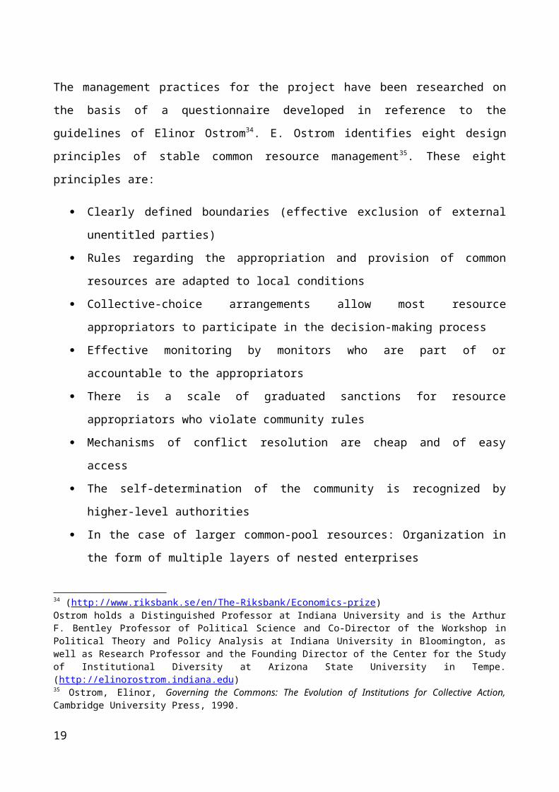
The management practices for the project have been researched on the basis of a questionnaire
developed in reference to the guidelines of Elinor Ostrom34. E. Ostrom identifies eight design
principles of stable common resource management35. These eight principles are:
Clearly defined boundaries (effective exclusion of external unentitled parties)
Rules regarding the appropriation and provision of common resources are adapted to local
conditions
Collective-choice arrangements allow most resource appropriators to participate in the
decision-making process
Effective monitoring by monitors who are part of or accountable to the appropriators
There is a scale of graduated sanctions for resource appropriators who violate community
rules
Mechanisms of conflict resolution are cheap and of easy access
The self-determination of the community is recognized by higher-level authorities
In the case of larger common-pool resources: Organization in the form of multiple layers of
nested enterprises
The last point of these design principles will not be part of the analysis as it applies to much larger
scenarios than the village commons in Rajasthan. This could apply to the governance of CPRs in
India in relation to the federal state´s policy, state policy and local/district policy.
These principals have undergone slight modification by Ostrom and Janssen in Working Together:
Collective Action, the Commons, and Multiple Methods in Practice (2010), to include a number of
additional variables believed to affect the success of self-organized governance systems, including
effective communication, internal trust and reciprocity36, and the nature of the resource system as a
whole.
In order to get a more comprehensive understanding of the CPR’s in the villages, some sub-
questions have been added. This is also done in order to turn the questionnaire closer to a real
conversation, and thereby, simplifying and breaking up the questions into two or more sub-34 (http://www.riksbank.se/en/The-Riksbank/Economics-prize) Ostrom holds a Distinguished Professor at Indiana University and is the Arthur F. Bentley Professor of Political Science and Co-Director of the Workshop in Political Theory and Policy Analysis at Indiana University in Bloomington, as well as Research Professor and the Founding Director of the Center for the Study of Institutional Diversity at Arizona State University in Tempe. (http://elinorostrom.indiana.edu) 35 Ostrom, Elinor, Governing the Commons: The Evolution of Institutions for Collective Action, Cambridge University Press, 1990.36 A relation of mutual dependence or action or influence.
13

questions. Altering the way of asking, to the perspectives of the interview group(s), such as
questions concerning dependency and leadership issues proved beneficial for the research. Both in
order for the interview group(s) to fully understand the aim of the question and in order to bring the,
sometimes technical questions, into the village sphere. The aim was to get more natural answers
through, enhancing the villagers understanding of the project aims and increased their trust in the
project and the researchers. Sometimes, to get a specific answer, a question focus point was
approached from several different perspectives and asked in different ways, such as aspect of
leadership, encroachment and dependency on the Commons.
The Questionnaire based on Ostrom’s principals1) What are the common property resources in the village and how are they used?
- Is there a clear understanding of the boundaries around the CPR’s and boundaries in
relation to who has access to the resources (user and/or owner right conflicts)
- Are there any conflicts over access to the CPR, both internal (village) and external
(between villages)
- Overlap between village and resources location
2) Who defines the boundary, rules, sanctions and access right of the CPRs?
- Leadership, corruption, conflicts and familiarity with changing external environments
- The homogeneity of identities, social norms and interests within the village
- Social/economic independence between the different groups
3) What are the main purposes of the CPRs in the village? (Grazing, fuel wood, timber, etc.)
- What is the general level of dependence upon the CPR
- Fairness in allocation of resources
4) What is the role of administrative authorities in protecting the CPRs?
- In relation to locally constructed rules of access and management
- The ease of implementing and in enforcing sanctions.
- The process of implementation and institutional management
5) What are the methods applied by villagers for improvement of the CPRs?
- Level of sanctions
- Accountability in following the rules/norms
- Past successful management experience
14

6) Who play the pivotal role in the development of CPRs and what is the level of participation
in decision making?
- Decision making is independent from external governance
- Accountability of officials towards the community
7) What is the source of water in the village and how it is maintained?
8) What are the institutions for development activities in the village and what is their role in the
same?
- Levels of aid/compensation from external governance to the community for conservation
activities.
- Local levels of assigning the process, provisions and general self-governance
9) What are the coping mechanisms used by the villagers in difficult situations?
- Change in conduct and management in times of drought and other hard situations.
10) What is the cropping season in the village?
- Relation between harvesting and the regeneration in the resources
Limitations: The case studies will only represent three different agro-climatic regions in Rajasthan,
although these three represent different cases in regards to climatic, cultural, topography and law -
related impacts on the CPR's, they do not represent the state as a whole, but will give a fairly good
understanding of the state. Within the district 2-3 villages have been selected for the study, although
they were selected due to certain parameters, such as tribal population, they are not representing the
district as a whole and cases of success and failure could have been overlooked. But due to time
limitation and the sheer expanse of the state of Rajasthan, the districts and the areas of CPRs
themselves, districts and villages were selected.
Regarding the land records and maps there are some limitations both due to the fairly old records
(1985), in some cases no representative from either the Forest Department or the Revenue
Department had visited and adopted the land records in a village for over 50 years, and due to the
use of on-site estimations. The use of GPS was not available, which in use with Google Earth could
have provided specific and exact land records.
Topography limitations: Due to the steep mountains, forest and sheer size of the areas it was not
always possible to walk or view the entire area to estimate the situation. The walks of the areas was
in those cases planned to cover most of the area and to include specific sites, such as water
15
conservation efforts, areas of conflict and sites with a good overview of the area in order to make a
valid estimate of the status.
4.0 Theory
In this section the two conceptual frameworks used in this thesis, by Garrett Hardin and Elinor
Ostrom, will be described. Garrett Hardin´s “Tragedy of the Commons” is based upon classical
liberal economic theory and its assumptions about human and market behaviour, concerning the
rational individual and profit maximization, which will lead to overexploitation. Elinor Ostrom´s
“Governing the Commons” focuses on community management and build upon the assumptions
that CPRs are often not the open-access resources Hardin describe them as, and the actors’
behaviour is not associated with the term of a profit maximizing rational individual from the liberal
economic theory. Both frameworks focus on usage, access and governance of Common Property
Resources, but as stated, have different approaches and assumptions on this subject.
The reason for choosing these two theories are: The influence of Hardin´s Tragedy on development
policy, his conclusion of either private property or Government control as the only way out of the
dilemma and his refusal of the user’s ability to create sustainable local management. Ostrom´s more
recent theory has been chosen due to her focus on the ability of the community to manage their
commons, her refusal of the liberal rational behaviour as the sole motivator and the communities
ability to remove themselves from the dilemma of overexploitation and destruction of their
livelihood.
4.1 Garrett Hardin - Tragedy of the Commons:
The Tragedy of the Commons, which have become an integral part of “conventional wisdom”
regarding environmental studies, resource science and policy, economics and political science37,38,
refers to the social dilemma put forth by the ecologist, Garrett Hardin, in 1968.
Hardin´s theory provides a concept of understanding on how we have come to the brink of
numerous environmental disasters. His thesis is that people face dangerous situations, not because
of a malicious outside force, but because of the behaviour of many individuals acting alone39.
37 The Tragedy of the Commons: Twenty Two years after, Feeny; Berkes; McCay; Acheson, 199038 The Drama of the Commons, T. Dietz; N. Dolsak; E. Ostrom; P. Stern, National Academy Press, 200139 Tragedy of the Commons, R. De Young, 1999
16

Hardin´s article The Tragedy of the Commons both challenged and inspired its contemporary
generation. The article is one of the most cited publications of recent times, as well as one of the
most influential for ecologists and environmental policy researchers (E. Ostrom)40. Hardin´s
Tragedy of the Commons has its roots in classical liberalism and many of the assumptions are based
on classical liberal economic theory, such as Adam Smith´s invisible hand and the rational
individual profit maximizer41.
It was published at a time when environmental concerns were emerging from local- to global issues
and a period where other major works, such as The Population Bomb (Ehrlich, 1968) and The Limit
to Growth (Meadows, 1972) had serious attention from policy-makers and academics42. These
works had similar conclusions: The global environment was threatened by fundamental human
characteristic43. For Ehrlich it was the desire to reproduce, for Meadows; the tendency to endlessly
expand our production and consumption of goods and for Hardin; our short-sightedness and our
tendency to look out for our-selves first44. In general, the conclusion was: Humanity was forced to
change or find a way to restrain human nature45.
Hardin uses the word Tragedy as the philosopher Whitehead46 used it: "The essence of dramatic
tragedy is not unhappiness. It resides in the solemnity of the remorseless working of things”47.
Although Hardin is properly one of the most influential researchers on this subject, many were
sceptical towards the commons long before him. “What is common to the greatest number has the
least care bestowed upon it. Everyone thinks chiefly of his own, hardly at all of the common
interest”. Aristotle, Politics, Book II48.
Since the early studies of Common Property Resources by Gordon (1954) and Scott (1955)
economists have analyzed common property resource systems using relatively similar assumptions
and Garrett Hardin is a clear example of this49. In these systems it is assumed that:
- The resource generates a predictable, finite supply of one type of resource unit in each relevant time period.
40 The Tragedy of the Commons: Twenty Two years after, Feeny; Berkes; McCay; Acheson, 199041 Tragedy of the Commons, R. De Young, 199942 Design Principles for Global Commons, P. Stern, 1992 43 Design Principles for Global Commons, P. Stern, 199244 Design Principles for Global Commons, P. Stern, 199245 Design Principles for Global Commons, P. Stern, 199246 Alfred North Whitehead, Science and the Modern World47 The Tragedy of the Commons, G. Hardin, p 1244.48 The Drama of the Commons, T. Dietz; N. Dolsak; E. Ostrom; P. Stern, National Academy Press, 200149 Reformulating the Commons, E. Ostrom, 2000
17

- Users are assumed to be homogenous in terms of their assets, skills, discount rates, and cultural views.
- The users are short-term, profit-maximizing actors who possess complete information.
In this perspective, anyone can enter the resource and utilize resource units. The user gain property
rights only to what they extract, which they then sell in an open competitive market 50. The open
access condition is a given and the users do not make any effort to change it, in terms of restricting
the access. The users act independently and do not communicate or coordinate their activities in any
way51.
The Tragedy.
Hardin exemplifies the “tragedy of the commons” in a scenario of a pasture land, with open access
to all. Furthermore, it is expected that each herder will try to keep the maximum number of
livestock on the pasture52, as rational profit maximizers. Hardin´s herder asks himself: What is the
utility for me of adding one more animal to my herd? According to theory, this has one positive
component and one negative53.
- The Positive:
The positive component is a function of the addition of one animal. Since the herder
receives all the benefits from the sale of the additional animal, the positive utility is close
to +1.
- The Negative:
The negative component is a function of the additional overgrazing created by one more
animal. Since the effects of overgrazing are shared by all the herdsmen, the negative
utility for any particular herdsman, connected to the commons, is only a fraction of -1.
In adding the components partial utility together, the rational herdsman concludes that, the only
sensible course for him is to add another animal to his herd and continue to do so54.
50 Reformulating the Commons, E. Ostrom, 200051 Reformulating the Commons, E. Ostrom, 200052 The Tragedy of the Commons, G. Hardin, Utah State University, 196853 Common Property Economics: A general theory and land use applications, Glenn G. Stevenson, 199154 Common Property Economics: A general theory and land use applications, Glenn G. Stevenson, 1991
18
Therefore, in Hardin's example it is in each herder's interest to put the next (and succeeding) animal
he acquires onto the land, even if the quality of the common is damaged for all as a result. This is
caused by herder receiving all of the benefits from an additional cow, while the damage to the
Commons is shared by the entire group. But it will be the rational conclusion of each and every
herdsman sharing the Commons, to add more animals in order to reap the benefits and share the
cost55. When all the herdsmen make this individually rational economic decision, the common will
be depleted or even destroyed, to the detriment of all and therein the tragedy of the commons56.
“The individual benefits as an individual from his ability to deny the truth even though society as a
whole, of which he is a part, suffers”57.
Hardin produces examples of this by pointing to cattle rages in the US where the increase in
livestock has come to a point where overgrazing leads to erosion and dominance of low nutrition
vegetation and towards the more commonly known overexploitation of the whale population58.
According to Hardin an appeal to conscience to desist from overexploiting the commons, would be
understood in two ways, an intended verbal communication and an unintended nonverbal59:
1. If you don't do as we ask, we will openly condemn you for not acting like a responsible citizen.
2. If you do behave as we ask, we will secretly condemn you for a simpleton who can be shamed
into standing aside while the rest of us exploit the commons.
Hardin states that responsibility should only be used in specific social arrangements, that create
coercion. In this sense Hardin argue that we should seek to create social arrangements that will
prevent the pasture land in becoming Commons, and thereby prevent the freedom of
overexploitation60, this would be either through private property arrangements or government
control. In other words, coercion through an outside agent61.
“Individuals locked into the logic of the commons are free only to bring on universal ruin; once
they see the necessity of mutual coercion, they become free to pursue other goals”62.
55 Common Property Economics: A general theory and land use applications, Glenn G. Stevenson, 199156 The Tragedy of the Commons, G. Hardin, Utah State University, 196857 The Tragedy of the Commons, G. Hardin, p. 124458 The Tragedy of the Commons, G. Hardin, Utah State University, 196859 The Tragedy of the Commons, G. Hardin, Utah State University, 196860 The Tragedy of the Commons, G. Hardin, Utah State University, 196861 Tragedy of the Commons, De Young, 1999.62 The Tragedy of the Commons, G. Hardin, Utah State University, 1968
19

Implicitly, the theory assumes that regulators will act in the interest of the public and understand
how ecological systems work and how to change institutions so as to induce socially optimal
behaviour63.
Open Access:
An open access resource is defined as a depletable, fugitive resource characterized by rivalry in
exploitation; it is subject to use by any person who has the capability and will to enter into harvest
or extraction of it; and its extraction results in negative externalities64.
The rivalry in production of an open access resource indicates that one agent’s extraction of the
resource excludes another agent possession. If one fisherman catches a fish, another can’t possess
the same fish. The rivalry in extraction indicates that the open access resource is not a pure public
good65 in all potential uses. The depletability of an open access resource reflects not only the rivalry
in extraction but also that a rate of use, that reduces the resource to zero, exists. The fugitive nature
of an open access resource means that it is “reduced to ownership by capture”. There are no
enforceable ownership rights over the resource in question66.
A maximum sustainable yield (MSY) should be reached, according to Stevenson, when the effort
going into the extraction of the resource will decline the reproduction, and therefore efforts beyond
the MSY will reduce the output and cause decline in revenue67. The yield-effort function is an
equilibrium concept, where, in a fishery, as efforts increase catch and revenue increase up to a point
where it meets the MSY. Further increase in effort would result in decline in catch levels, due to a
lower fish population and a slower reproduction, as well as a decline in revenue 68. At the point of
MSY the actors will be making a profit and this will attract new inputs, either from the actors
themselves or from new actors. But due to the open access of the resource, the existing actors
cannot prevent new actors from entering and thereby increasing the effort beyond the MSY or into
overexploitation69.
63 Questioning the Assumptions of the ‘Tragedy of the Commons’ Model of Fisheries, 199664 Common Property Economics: A general theory and land use applications, Glenn G. Stevenson, 199165 A pure public good is indicated by its non-consumptive nature and all benefit from its maintenance even if they do not contribute, e.g. weather forecasts.66 Common Property Economics: A general theory and land use applications, Glenn G. Stevenson, 199167 Common Property Economics: A general theory and land use applications, Glenn G. Stevenson, 199168 Common Property Economics: A general theory and land use applications, Glenn G. Stevenson, 199169 Common Property Economics: A general theory and land use applications, Glenn G. Stevenson, 1991
20

“...no level of “optimal rate output” can be maintained indefinitely, because of the open access
conditions: at such an effort level the fishermen would earn a profit, additional fishermen would be
attracted, and efforts would increase”70.
Population Growth:
According to Hardin, a finite world can only support a finite population, and therefore growth must
sooner or later equal zero71. Hardin argues, that the population growth, as well as his views on
human nature, is one of the main reason for the Tragedy and both should be seen through Adam
Smith’s optics of “the invisible hand”; each individual acts in its own interest and through that is
guided to promote the public interest72. The unlimited access to the Commons is what, according to
Hardin, causes the Tragedy73.
“To couple the concept of freedom to breed with the belief that everyone born has an equal right to
the commons is to lock the world into a tragic course of action.”74
Hardin criticises the UN declaration of human rights from 1967, stating that: ...the family is the
fundamental unit of society and it therefore follows that any decision regarding the size of the
family only rests with the family itself. Hardin denies, categorically, as he writes it, the validity of
this human right. Hardin states that, the most important necessity that should be recognized must be
the necessity in removing reproduction from the Commons75. In other words, to govern the
reproduction of mankind.
“The only way we can preserve and nurture other and more precious freedoms is by relinquishing
the freedom to breed, and that very soon. "Freedom is the recognition of necessity"-and it is the
role of education to reveal to all the necessity of abandoning the freedom to breed. Only so, can we
put an end to this aspect of the tragedy of the commons”76.
Hardin argues that, it would be a mistake to think that human reproduction could be controlled
simply by an appeal to conscience, due to the Darwinian belief that procreation is heredity;
70 Common Property Economics: A general theory and land use applications, Glenn G. Stevenson, 199171 The Tragedy of the Commons, G. Hardin, Utah State University, 196872 The Tragedy of the Commons, G. Hardin, Utah State University, 196873 Common Property Economics: A general theory and land use applications, Glenn G. Stevenson, 199174 The Tragedy of the Commons, G. Hardin, p. 124675 The Tragedy of the Commons, G. Hardin, Utah State University, 196876 The Tragedy of the Commons, G. Hardin, p. 1248
21

therefore it should be done through law77. He does not mention how this should be done within the
boundaries of democracy.
Avoiding the Tragedy:
By Hardin, the most straightforward way to achieve restraint towards resource extraction is through
coercion, administered by outside agents78. Hardin sees two possible solutions to create coercion,
either through centralized control or through private property. While privatization is the less severe,
it involves external actors and the force of law to defend the private property and to manage as they
see fit79. Creating property rights in the Commons would create a structure of rules that recognizes
dissipation and would work towards reducing or avoiding it80.
The creation of private property rights in the Commons would secure an exclusive right to resource
extraction that in turn would impart the incentive to the user to utilize the resource at an optimal
rate81. The private rights holder would not only reap the benefits but also incur all the cost of
additional resource extraction. A balancing of these benefits and costs would lead the user to an
optimal extraction rate, according to theory of common property economics82.
According to Hardin, taxing would be an effective coercion tool and to avoid enforcement of a ban
of the social behaviour, simply by making the norm increasingly expensive to do. Hardin also states
that the only form of coercion he would recommend would be a mutual coercion, mutually agreed
upon by the majority of the people affected83.
Hardin identifies two human factors that he believes, drive environmental change: Firstly; the
increasing demands for natural resources and environmental services, due to the growth in
population and per capita resources consumption. Secondly; the way humans organize themselves
into institutional arrangements to extract resources from the environment and eject waste into it84.
Hardin argues that, only two state-organized institutional arrangements could sustain commons in
the long run, private property and State Government85.
77 The Tragedy of the Commons, G. Hardin, Utah State University, 196878 Tragedy of the Commons, De Young, 1999.79 Tragedy of the Commons, De Young, 1999.80 Property Rights: Cooperation, conflict and law, T. Lee Anderson, 200381 Common Property Economics: A general theory and land use applications, Glenn G. Stevenson, 199182 Common Property Economics: A general theory and land use applications, Glenn G. Stevenson, 199183 The Tragedy of the Commons, G. Hardin, Utah State University, 196884 The struggle to Govern the Commons, T. Dietz, E. Ostrom, P. Stern, SCIENCE vol. 302, 200385 The struggle to Govern the Commons, T. Dietz, E. Ostrom, P. Stern, SCIENCE vol. 302, 2003 (Ibid)
22

Hardin´s view can be stated as follows: If a group of people are placed in a situation where they
could mutually benefit if all adapted to a set rule of restrained use, they will not do so in the absence
of an external enforcer of agreements, due to their self-interests.
Critique of Hardin´s Tragedy of the Commons
As stated, Hardin uses a form of game theory to analyse the commons and his example of the open
pasture land. Although, he does not use the well known Prisoners' Dilemma, his argument shares
the same assumptions and can be represented as a variant of this model86. Just as the Prisoners'
Dilemma, Hardin's example assumes that the individual herder has no information about the
aggregate state of the commons and its proximity to collapse, as well as there is no communication
between the herders87. This assumption permits Hardin to have the herder make a decision just prior
to collapse, that is against his own self-interest, to add another animal and thereby initiate the
collapse, with the consequence that he, as well as the others, lose it all88.
The issue of critique is the amount of information people have about the larger situation in which
they function. According to Wade, the informational assumption does not make sense in the usual
village situation89. Here, monitoring the condition of the commons, and of cheating, is frequently
and fairly easy.
Hardin does not make the distinction between situations of no property and situations of common
property. He begins his argument by assuming 'a pasture open to all'. The case is quite different
where a joint ownership unit exists, and access is open only within the bounds of this unit, such as
the Joint Forest Management system. Here the chances of getting compliance with rules of
restrained access are much better90. By ignoring the distinction, Hardin generalise the results for no
property to cover common property as well. According to Wade, cases of successful common
resource management have all involve common property rather than no property91.
86 Robert Wade; Cambridge Journal of Economics, 198787 Robert Wade; Cambridge Journal of Economics, 198788 Robert Wade; Cambridge Journal of Economics, 198789 Robert Wade; Cambridge Journal of Economics, 198790 Robert Wade; Cambridge Journal of Economics, 198791 Robert Wade; Cambridge Journal of Economics, 1987
23

4.2 Elinor Ostrom - Governing the Commons:
The Nobel Prize award was bestowed upon Elinor Ostrom for her work on Common Properties. Her
work contradicts Garret Hardin’s theory of the “Tragedy of Commons” and goes one step further to
tell us that under certain conditions the commons have been effectively governed.
Elinor Ostrom, and others, argue that Hardin has an oversimplified approach in two ways; firstly,
only private property or centralized government can save the environment in the long run and
secondly, the resource users are locked in the tragedy dilemma, incapable of creating a solution92.
“…many social groups, including the herders on the commons that provided the metaphor for his
(Hardin) analysis, have struggled successfully against threats of resource degradation by
developing and maintaining self-governing institutions”93.
Ostrom argues that the logic of the tragedy of the commons rests on a set of assumptions about
human behaviour concerning governance and the use of commons and of the nature of the
resource94. According to Ostrom, Hardin´s model is too simple to cover the reality of the commons
and of human behaviour. “Human motivation is complex, the rules of governing the real commons
do not always permit free access to everyone, and the resource systems themselves have dynamics
that influence their response to human use”95.
Ostrom states that, the empirical data from the last 30 years tell a rich and complicated story of the
commons. Sometimes it is the history of Hardin´s tragedy, but often the results are filled with
ambiguity and fall outside Hardin´s story96. She opposes the view of the rational actor that
dominates most economic theory, with a view that assumes that humans take account of the
interests of the group. The tragedy of the commons presumes the only motivator to be self-interest
and social mechanisms to control the self-interest, such as trust, communication and the ability to
make binding agreements (formal or informal), is either lacking or unsuccessful97. Ostrom does not
reject that such conditions apply to some interactions, but sometimes people do move beyond the
individual interest. Trust, communication and the anticipation of future interactions can control the
self-interest enough to prevent the tragedy98.
92 The struggle to Govern the Commons, T. Dietz, E. Ostrom, P. Stern, SCIENCE vol. 302, 200393 The struggle to Govern the Commons, T. Dietz, E. Ostrom, P. Stern, SCIENCE vol. 302, 2003 (Ibid)94 The Drama of the Commons, T. Dietz; N. Dolsak; E. Ostrom; P. Stern, National Academy Press, 200195 The Drama of the Commons, T. Dietz; N. Dolsak; E. Ostrom; P. Stern, National Academy Press, 200196 The Drama of the Commons, T. Dietz; N. Dolsak; E. Ostrom; P. Stern, National Academy Press, 200197 The Drama of the Commons, T. Dietz; N. Dolsak; E. Ostrom; P. Stern, National Academy Press, 200198 The Drama of the Commons, T. Dietz; N. Dolsak; E. Ostrom; P. Stern, National Academy Press, 2001
24

According to Ostrom and Runge, most users of common property resources, especially in the
developing world, live in the same village where their families have lived for generations and plan
to stay for generations to come. Given the general poverty facing most villagers and the
unpredictability of the natural resources they all face, it is doubtful to suppose that the individuals
have a “free-rider” strategy as a dominant motivation99. Runge, as well as Ostrom, argues that
common resource users in developing countries face a repeated coordination game instead of the
one-try Prisoner´s Dilemma game, Hardin rely upon100. In such situations all users would favour to
limit their own use, as long as others committed themselves to the limitations as well. And the
village institutions would provide a mechanism for the group as a whole to arrive at agreements that
would ensure each user the others was committed to the agreed upon rules101. Therefore the issue of
the commons would be a coordination problem and not a dilemma.
Ostrom agrees with Hardin, that without appropriate and effective governance institutions the
environment and its natural resources will be in danger from increased population and consumption
as well as overexploitation through modern technologies102. Each individual has an incentive to
ignore the social costs of his resource use for fear that others will capture the benefits before he can.
The lack of exclusion from the resource can thus create an incentive for aggregated use which
exceeds the natural regeneration of the resource (Ostrom, 1985)103. Although, local institutions have
not always succeeded in maintaining the resource in question, neither have Hardin’s alternatives of
either state- or private-ownership.
Ostrom uses the global ocean as an example of a threat of immense ecosystem degradation,
resulting from; interplay among ocean ecology, fishing technology and inadequate governance104.
Ostrom criticizes the top-down national regimes and rule-systems and argues that it leaves the local
users and -officials with insufficient autonomy and understanding to design effective institutions
and management systems. Ostrom argue that; rules created on models that have no or little
credibility among the users and as a result compliance to the rules have been relative low and strong
resistance towards strengthening the existing restrictions105.
99 The Drama of the Commons, T. Dietz; N. Dolsak; E. Ostrom; P. Stern, National Academy Press, 2001100 The Drama of the Commons, T. Dietz; N. Dolsak; E. Ostrom; P. Stern, National Academy Press, 2001101 The Drama of the Commons, T. Dietz; N. Dolsak; E. Ostrom; P. Stern, National Academy Press, 2001102 The struggle to Govern the Commons, T. Dietz, E. Ostrom, P. Stern, SCIENCE vol. 302, 2003 (Ibid)103 Robert Wade; Cambridge Journal of Economics, 1987104 The struggle to Govern the Commons, T. Dietz, E. Ostrom, P. Stern, SCIENCE vol. 302, 2003 (Ibid)105 The struggle to Govern the Commons, T. Dietz, E. Ostrom, P. Stern, SCIENCE vol. 302, 2003 (Ibid)
25

According to Ostrom, the creation of governance systems for an sustainable use of the earth’s
resources, that include a reasonable quality of life, involve making decisions under conditions that
are uncertain, complex, with significant biophysical constrains and conflicting human values and
interests106. A set of laws or rules created under a certain socio-ecological environment, can change
or erode as social, economical, environmental and/or technological development increase the
potential for resource acquirement or change the environment from where the resource is
collected107. Furthermore Ostrom states that, humans have a tendency to devise methods for evading
governance and therefore the rule-set needs to be able to evolve with the environment as a whole.
According to Ostrom, effective governance of commons is best achieved when:
The resources and use of the resources by humans can be monitored, and the information
can be verified and understood at relatively low cost.
Rates of change in resources, resource-user populations, technology, and economic and
social conditions are moderate.
Communities maintain frequent face-to-face communication and dense social networks.
Outsiders can be excluded at relatively low cost from using the resource.
The users support effective monitoring and rule enforcement.
Regarding dense social network and face-to-face communication, the argument is that it will
increase trust among the members, allow people to express emotions and see reactions to distrust as
well as lowering the cost of monitoring compliance to the rules. Exclusion of outsiders is important
due to the increased harvesting pressure on the given resource and a typical lack of understanding of
the rules by the newcomers.
Although, only very few situations in the world are characterized by all of these conditions, the
challenge, according to Ostrom, is to create institutional arrangements that help facilitate such
conditions, or as a main create governance in the absence ideal conditions108. Ostrom refers to
Robert M. Netting´s research in the Swiss Alps109 and his five resource characteristics that would
relate to forms of common property being created by the users110.
The value per-unit production is low
106 The struggle to Govern the Commons, T. Dietz, E. Ostrom, P. Stern, SCIENCE vol. 302, 2003 (Ibid)107 The struggle to Govern the Commons, T. Dietz, E. Ostrom, P. Stern, SCIENCE vol. 302, 2003 (Ibid)108 The struggle to Govern the Commons, T. Dietz, E. Ostrom, P. Stern, SCIENCE vol. 302, 2003 (Ibid)109 What alpine peasants have in common: Observations on communal tenure in a Swiss village, 1976110 The Drama of the Commons, T. Dietz; N. Dolsak; E. Ostrom; P. Stern, National Academy Press, 2001
26

The frequency and dependability of yield is low
The possibility of improvement is low
The area required for effective use is large
The size of the group needed to make capital investments is large
The opposite characteristics would, according to Netting, make the users create forms of private
property. Common property regimes developed under these conditions have been sustained for
centuries without overexploiting the resource111.
Under specific conditions common property regimes will be more beneficial than private property.
These conditions would be when:
The cost of creating and enforcing private property rights is high
The economic value of the output is low
The benefits created by the resource are distributed with high spatial uncertainty
Under such conditions, a common property system would provide a way of reducing the risk of
having nothing at all, in a period of time, and therefore preferable to private property112.
According to Ostrom the research should be focused, not on a quest for the “correct” overall
concept and the single right policy, but on an understanding of the conditions under which
specific institutional models provide beneficial for the users in sustaining their resources over a
long period of time, also known as design principles113.
In her book Governing the Commons: The Evolution of Institutions for Collective Action, from
1990, Ostrom formulated eight principles for where community based organization would
function114, based on discussions on the National Research Council appointed panel on the Study
of Common Property Resource Management, as well as a long series of field studies from all over
the world.
Clearly defined boundaries (effective exclusion of external parties)
Rules regarding the appropriation and provision of common resources are adapted to local
conditions
111 The Drama of the Commons, T. Dietz; N. Dolsak; E. Ostrom; P. Stern, National Academy Press, 2001112 The Drama of the Commons, p.15, T. Dietz; N. Dolsak; E. Ostrom; P. Stern, National Academy Press, 2001113 The Drama of the Commons, p.16, T. Dietz; N. Dolsak; E. Ostrom; P. Stern, National Academy Press, 2001114 Governing the Commons: The Evolution of Institutions for Collective Action, E. Ostrom, Cambridge University Press, 1990.
27

Collective-choice arrangements allow most resource appropriators to participate in the
decision-making process
Effective monitoring by monitors who are part of or accountable to the appropriators
There is a scale of graduated sanctions for resource appropriators who violate community
rules
Mechanisms of conflict resolution are cheap and of easy access
The self-determination of the community is recognized by higher-level authorities
In the case of larger common-pool resources: Organization in the form of multiple layers of
nested enterprises
As mentioned in the method chapter, the last point will not be part of the analysis in this thesis, as
the focus of the thesis is not on the large scale organisation of the Indian Commons.
To summon up on the theory chapter, the key aspects from the two theories are; from Hardin´s: The
individuals are solely motivated by personal gains, they are a homogeneous group with no
difference in terms of culture, skills and assets, they have a fear of losing access if they don´t
exploit before someone else does, the open access to the resource and that the users are trapped in
the Tragedy and are unable to resolve the situation themselves, and thereby unable to create local
institutions to manage the commons effectively. As the solution to the Tragedy Hardin has two
options; private property or government control.
The key aspects from Ostrom, as stated in her design principles, are; cheap and easy exclusion of
outsiders, a high cost of enforcing private property, an effective and local decision-making process,
effective monitoring of both users and the resource, guaranties sanctions toward rule breakers as
well as accountability towards the rules, easy and local conflict resolution and the recognition of the
local authority by government officials.
With this, the focus of the analysis will be to investigate the field data through the lens of the two
theories to understand the condition of the Commons and the motivations of the appropriators for
their usage and management of the CPRs.
28

5.0 Introduction of Cases
Rajasthan/Rajputana literally means "the land of kings" or "the land of kingdoms", with the
dominating cast being Rajput, and it is the largest state of the Republic of India by area 115 and it
covers much of the area of the Thar Desert. The state is bordered by Pakistan to the west, Gujarat to
the southwest, Madhya Pradesh to the southeast, Uttar Pradesh and Haryana to the northeast and
Punjab to the north. Rajasthan covers 10.4% of India´s land mass, an area of 342,269 km2.116 The
present State of Rajasthan was formed after a long process of integration which began on March 17,
1948 and ended on November 1, 1956117.
One of the world's oldest mountain ranges, the Aravalli Range dominates the landscape from the
south-west travelling north-east towards Delhi and Punjab, from the districts of Udaipur and Sirohi
towards the district of Alwar, for more than 850 km118. The Aravalli hills create a natural barrier to
the desert and divide the state into two ecological "zones"; the arid north-west and the semi-arid
south-east119.
115 http://www.rajasthan.gov.in/rajgovt 116 http://www.rajasthan.gov.in/rajgovt 117 http://www.rajasthan.gov.in/rajgovt/misc/statehistory.html 118 http://www.rajasthan.gov.in/rajgovt 119 Geomorphic Significance in the environmental problems of the Rajasthan desert, India, Surendra Singh; Bimal Ghose, CAZRI, Jodhpur, 1980
29

In Rajasthan, Hindus account for 88.8% of the population, Muslims make up 8.5%, Sikhs 1.4% and
Jains 1.2% of the population120. The state of Rajasthan is also populated by Sindhis, who came to
Rajasthan from the Sindh province (now in Pakistan) during the India-Pakistan separation in
1947121. The total population of Rajasthan is estimated to be more than 68 million according to the
2011 census122.
Common Property Resources (CPRs/Commons) are land resources owned and managed by a
local community, rather than controlled by governments (public/government resources), or owned
by individuals (private resources). "Rural common property resources are broadly defined as,
resources towards which all members of an identifiable community have inalienable user rights. In
the Indian context CPRs include Community Pastures, Community Forests, Government
Wastelands, Common Dumping and Threshing Grounds, Watershed Drainages, Village Ponds and
Rivers etc. The first three resources are particularly important because of their large area and their
contribution to people's sustenance."123
It is helpful to distinguish between the type of property right and the type of resource, to allow for
the fact that the same type of resource may be exploited under a range of property rights. Common
pool resources are to be understood as a sub-set of public goods (as that term is used in economics).
All public goods have the property that many can use them at the same time, because exclusion is
difficult. Some public goods yield infinite benefits, in the sense that if A uses more there is no
reduction in the amount available for others (e.g. lighthouses and weather forecasts). Common-pool
resources, by contrast, are public goods with limited or subtractive benefits; if A uses more, less
remains for others. Common-pool resources are therefore potentially subject to congestion,
depletion, or degradation, i.e. extraction which is pushed beyond the limits of sustainable yield.
Fresh water, for example, is a common property resource: it can be used jointly, because of the high
cost of excluding a landowner with nearby land; and its consumption is subtractive in the sense that
water applied to A's land is not simultaneously available for B's124.
The rural poor with limited alternative means of income, depends largely on the benefits from the
CPRs. Whereas, the rural rich have a very low dependency on the CPRs125. This dependency is even 120 http://www.censusindia.gov.in/ 121 http://www.censusindia.gov.in/122 http://www.censusindia.gov.in/123 Depletion of Common Property Resources in India – Micro-level evidence, N. S. Jodha, 1989124 The management of common property resources, Cambridge Journal of Economics, Robert Wade, 1987125 Rural Common Property Resources, N.S. Jodha, 1990
30

more significant in India’s arid and semi-arid regions, such as Rajasthan, due to the harsh
environment126. According to Jodha´s study, the poor households dependency on the CPRs for
fodder and food items rages from 84% to 100%, the equivalent dependency for rich households in
Rajasthan rages from 10% - 19%127. Despite the CPRs significant and valuable contribution to the
livelihood of the rural population, they are among the most neglected areas within development
planning in India128.
The previous Indian literature regarding the CPR (Jodha) consider the significant importance of the
commons revolve around two major points; the importance for ecology and to the livelihood of the
rural poor129. The CPRs contribution are abundant, and includes; local employment, income
generation and asset accumulation. Nevertheless, due to the daily routines these are seldom
recorded or recognized130. They range from the direct and more visible contributions in terms of
physical supplies to the less visible gains implied by sustainability of agro-ecological systems. This
sort of invisibility of CPR contributions, according to Jodha, is more prominent in the case of long-
term social and ecological processes characterising dry areas131. According to Jodha´s field study,
the CPRs in Rajasthan contributes to the poor households on an average with 71% of the fuel wood
used for the year, 84% of the annual fodder, 165 days of employment and 23% of the annual
income132 per household133. However, CPRs in India´s arid and semi-arid regions face a significant
crisis and at the present status, the CPRs cannot meet the local needs. This is reflected through their
general shrinkage in area, decline in productivity and general degradation and breakdown in local
management systems134. According to Jodha, the decline in area has been fairly easy to observe
through village interviews and records of land use. On the other hand, the decline in productivity,
although clearly felt in the villages, is difficult to quantify due to the productivity have never been
recorded in the past135.
The local ecology and community receive direct benefits from a well vegetated CPR, through the
lessened soil erosion and the higher level of soil moisture, as well as effective water conservation
126 Rural Common Property Resources, N.S. Jodha, 1990127 Rural Common Property Resources, N.S. Jodha, 1990128 Common Property Resources and Rural Poor in Dry Regions of India, N.S. Jodha, 1986129 Rural Common Property Resources, N.S. Jodha, 1990130 Rural Common Property Resources, N.S. Jodha, 1990131 Rural Common Property Resources, N.S. Jodha, 1990132 Income mainly through CPR product collection. The estimation procedure underestimated the actual income derived from CPRs. (Jodha, 1986)133 Rural Common Property Resources, N.S. Jodha, 1990134 Rural Common Property Resources, N.S. Jodha, 1990135 Rural Common Property Resources, N.S. Jodha, 1990
31

efforts to keep the water supply up for the harsh summer period. The erosion and soil moisture are
interconnected through vegetation136. A high level of vegetation, and thereby a large root network
from the top soil to deeper levels, will prevent much the soil run off during the monsoon as well as,
lessening the evaporation of water and in arid regions, such as western Rajasthan, this is of critical
importance137.
Farming in rural Rajasthan is mainly rain fed, and therefore subsistence orientated in nature. The
continued degradation of the forest has affected the soil and water system in the agricultural lands
located in the plains and downstream. This leads to more frequent droughts, and food and income
shortages as result of the top soil being washed away by the monsoon. Another trend towards
overgrazing has been the change in the farming techniques; instead of letting livestock graze on the
crop fields after harvest, farmers sow a second or third crop, without letting the land pause to
regenerate138. In effect, this means that the fodder obtained from the post-harvest fields is not
available and additional fodder must be obtained from the CPRs.
Due to the farming based livelihood of the rural population, the levels of soil moisture, silt run off
and a stable and nutritious layer of top soil will have significant effects on the farming productivity,
both in agricultural and livestock based farming. Although the livestock farming is not directly
affected by e.g. erosion, they are affected indirectly through the availability of fodder for grazing
and harvesting. As mentioned the landless households in Rajasthan are especially dependent on the
CPR's to make ends meet.
The problems concerning common lands in the state are not merely physical in terms of degradation
or sub-optimal productivity, which can be addressed with relative ease through technological
options, but also socio-political in nature, often requiring long drawn attempts at reconciliation of
stakes of various sections of the community and advocating for accommodation of these interests.
5.1 Case Descriptions
In the following case studies the question of how the local management is influencing the condition
and status of the CPRs will be investigated both through interviews conducted in all villages and
through estimates of the land status. This is done in order to understand the background of the
institutional organisations and to investigate the current situation of the Commons.
136 Geomorphic Significance in the environmental problems of the Rajasthan desert, India, Singh; Ghose, 1980137 Geomorphic Significance in the environmental problems of the Rajasthan desert, India, Singh; Ghose, 1980138 Sustainable Management of Pasture and Rangelands; Stuth & Maraschin; 2000
32

5.1.1 Case I: Udaipur District
Udaipur district is located in the south of Rajasthan and dominated by the Aravali Hills, one of the
oldest mountain ranges in the world. The area is characterized by semi-arid climatic conditions and
undulating terrain. Many of the hills are barren and the area is marked by scarcity of rainfall, which
usually takes place during monsoon months. On top of this, the low levels of vegetation increases
water erosion by the monsoon, and wash-off of nutritious soil, leaving the land less fertile and
barren. According to the Rajasthan Government Statistics from 2007, out of the total population of
2.63 million, 81.4% lives in the rural areas139.The total population of Udaipur District has increased
by about 600.000140 since 1999 and according to the State Statistics 47.86% of the total population
in the district belong to a Scheduled Tribe and 6% to Scheduled Caste groups141. The population in
Udaipur is mainly rural and heavily depends on natural resources for their survival142. However, due
to the increase in human and livestock population and the high level of dependency of the natural
resource, the common lands have been severely degraded over the last 15 years through
overexploitation, misuse and encroachments. This has resulted in a variety of negative
environmental and social impacts, which may see the future subsistence of the land uncertain.
Water scarcity, diminished land quality and small landholdings place severe constraints on
agricultural productivity. Therefore, in addition to widespread involvement in agriculture and
animal husbandry a large section of the rural population, including the youth, have become heavily
involved and dependent on various forms of casual labour, migrating for work on a daily or
seasonal basis143. While the local population is largely dependent on natural resources for their
139 http://www.statisticstest.rajasthan.gov.in/socio_Udaipur.aspx 140 From 2066580 in 1999 to 2633312 in 2007141 http://www.statisticstest.rajasthan.gov.in/socio_Udaipur.aspx142 6th Comprehensive plan, Seva Mandir, 2009143 6th Comprehensive plan; Seva Mandir; 2009
33
“In the hills, not so arid areas of the south, land consolidation is an important policy option, as at present fragmented form of lands makes it very difficult to promote value addition in agriculture. Here, the general practice of the ST communities of claiming the land as new families are formed—a practice from the expansive agriculture era—brings marginal lands under the plough, leads to cutting of the woods and further fragmentation of the existing land. This must, now, give way to more sustainable styles of land use. For this, a new settlement process must be initiated.”
Government of Rajasthan, Human Development Report, 2008.
livelihood, most of the commons have fallen victim to overgrazing and encroachment144.
Furthermore, these processes of degradation have been amplified by the fragile nature of the land,
which makes the area vulnerable to droughts and limits the possibility of developing new alternative
activities to increase the productivity of lands. The economic condition of these tribal communities
can be gauged from the fact that roughly 44 % of all families live below the poverty line145.
As the immediate livelihood needs are increasingly being met through labour migration, the
destruction of the local ecology for short-term private gain has increasingly become the norm146. At
present, with continuously growing demand for resources and the growing value of lands, the
commons are increasingly becoming subject of speculation. As the state seeks to encourage
economic growth, it is increasingly unlikely that fragmented communities will be able to compete
with powerful business interests who see large profits in utilizing the lands. This presents a serious
threat to the local ecology and, therefore, the very foundation of sustainable local livelihoods147.
5.1.1.1 Ramaj
See appendix II for Ramaj village details
Village Statistics :
All parcels smaller than one hectare were omitted from the survey. Subsequently 70% by area of
total common land was surveyed, yet only 15% by number of parcels, indicating that a small
number of parcels represent the majority of common land in Ramaj.
Parcels surveyed
Total area (ha) surveyed
0% 10% 20% 30% 40% 50% 60% 70% 80% 90% 100%
14.99%
72.46%
Figure 1 – Level of Survey
144 6th Comprehensive plan; Seva Mandir; 2009145 6th Comprehensive plan, Seva Mandir, 2009146 6th Comprehensive plan, Seva Mandir, 2009147 6th Comprehensive plan, Seva Mandir, 2009
34

The total de facto area (pastureland, revenue waste land and barren and uncultivable land) is of
318.64 ha compiling of 467 parcel units. The surveyed land area is 230.88 ha, 70 parcel units. In
terms of percentage it is 72.46% of land in merely 14.99% of the parcel units.
Pastureland
Revenue Wasteland
Barren and uncultivable
TOTAL
0% 20% 40% 60% 80% 100%
41.51%
43.40%
6.93%
92.64%
86.49%
59.42%
Total area (ha) surveyedParcels surveyed
Figure 2 - Level of Survey by land categories
The surveyed pasture land in area is 75.8 ha, which is 92.64% of the total pasture land in Ramaj.
The surveyed revenue land area is 45.91 ha which amounts to 86.49% of the total revenue
wasteland. The surveyed Barren and Uncultivable land area is 109.18 ha which cover 59.42% of the
total Barren land category. Barren and Uncultivable land is the major land mass in Ramaj with a
total area of 183.75 ha in 361 parcel unit. The surveyed parcels in the Barren and Uncultivable land
covered merely 6.93% of the total parcel units, with an average parcel area of 4.3 ha, but covered
nearly 60% of the total category.
35

Table 1 - Level of Survey
Pastureland Revenue WastelandBarren and uncultivable Total
Total area of land (ha) 81.81 53.08 183.75 318.64
Area of land (ha) surveyed 75.79 45.91 109.18 230.88
Level of surveying 92.64% 86.49% 59.42% 72,46%
Total number of parcels 53 53 361 467
Number of parcels surveyed 22 23 25 70
% of parcels surveyed 41.51% 43.40% 6.93% 14,99%
Some caution is warranted regarding Ramaj village, as it is considered to be a typical representative
of the common land scenarios. There is no forestland in Ramaj, which eliminates forest resource
use, deforestation and additionally, the unique set of institutional and legal implications of Forest
Department jurisdiction.
Level of encroachment
Table 2 - Level of encroachment by land category
PasturelandRevenue Wasteland Barren and Uncultivable TOTAL
Area of land (ha) 75.79 45.91 109.18 230.88
Encroached Area (ha) 23.56 35.495 101.51 160.565
Level of encroachment 31.09% 77.31% 92.97% 69.54%
Table 2 shows the level of encroachment in land categories, and according to the findings Ramaj
has a high average level of encroachment on the commons.
Although, there is a difference between the categories ranging from 31% in pasture lands, 77% in
revenue wasteland and to 93% in uncultivable land. The high level of encroachment found in
Revenue Wasteland is closely connected with the policy of regularization, this could indicate
Hardin´s model of behaviour. The individual farmer has knowledge of the regularization policy,
although the process often takes 10-15 years, the bribes and fines that come with the encroachment
are fairly low and the fines are often never given. While the individual farmer will gain all of the
benefits from the additional land and in the end could get the land allotted through government
policies. The degeneration to the rest of the Revenue Wasteland will only affect him mildly. The
36

high amount of encroachments could also indicate the fear of losing access to the resources, due to
others encroachment, as a high motivator for further encroachments. This would be in accordance to
Hardin´s non-verbal understanding of the desistance to overexploit.
The relatively low level (31%) of encroachment on pastureland reflects the consistent effort over 25
years, undertaken by villagers to protect the pastures. The pasture land in Ramaj shows that
community organization have functioned, although not perfect, it is still far from the encroachment
levels of the other categories. The highest level of encroachment (93%) occurs on barren and
uncultivable land, which cannot be allotted. This could point to a lack of knowledge of the current
land laws in the village, and the rights of use and allotment following these laws. But it could also
be a sign of a difference between, what the villagers determine as common land and what is stated
in the revenue records, an example of De Facto village commons.
Status of Vegetation
In Ramaj there is no forest land and only sparse tree vegetation is present on the land categories that
are recorded in revenue department documents. The villagers stated that most of the forest was sold
off as timber shortly after independence. Although, there is currently no evidence to prove this
statement, other than the statement from the villagers, it is not an uncommon scenario during the
governance changes during the early days of independence. The fact is that there is no forest in
Ramaj anymore.
The vegetation shows some notable differentiation across the land categories. Barren and
uncultivable land has the lowest level of vegetated area. Pastureland shows the highest level of
vegetation, this is mainly due to the long effort by the community and NGO to protect the pasture
land in Ramaj. The Village Development initiatives largely account for the whole difference and
have had a big and positive effect on the village plantation efforts and concerns towards the
regeneration of the pasture land.
37

46.61% 21.54% 4.29%45.32% 68.08% 69.92%8.07% 10.38% 25.78%
Vegetation type by land classification
Well Vegetated Sparsely VegetatedScrub
Figure 3 - Vegetation type by land classification
Village data Conclusion :
The level of encroachment (69.5%) across the land categories in Ramaj is high and it promotes
honeycombing. Moreover, parcels with partial encroachment might be completely inaccessible to
villagers because of the encroaching households’ staking claims to the lands.
The Pastureland Development initiative remains a notable exception in the village. In relation to
this, the old encroaching households, that were removed prior to the demarcation, have begun to
send their cattle for grazing on the land during the last couple of years, claiming rights to the land or
wanting compensation in other areas. On the pasture land developed in 2005-06, there were
extensive encroachments before the area was enclosed. These encroachments were removed and the
land marked by a boundary of cactus plants148. But during the last two years the former encroachers
have begun to send their cattle for grazing inside the boundary and stake a claim for their old land
holdings. The claim is; the former encroachers had an agreement with the Panchayat of getting the
land back after 5-6 years or get land allotted in another Phalla149, being the revenue wasteland, ergo
government land holdings that can be allotted. They feel they have been unfairly treated since many
other encroachers are still present in other areas of the village.
The high rate (92.97%) of encroachment on Barren and Uncultivable land is unexpected, given that
villagers cannot receive these lands through regularization. One possibility is that Revenue
148 This cactus is commonly use for demarcation of land in the region, due to its hostile and resilient nature, its slightly poisonous juice and its quick growth.149 Section within the village. Each village/Township is divided into a few Phallas, some up to 15.
38

Department officials could change the category of a parcel to revenue wasteland, which can then be
allotted as private agricultural land. Experience shows that bribery and other irregular activities,
between villagers and government officials play an important role in allotment, making this a
possibility. Encroachment on revenue wasteland, a category that can be allotted by the Revenue
Department, is expected as villagers can stake a claim for future allotment while cultivating land, all
at the cost of relatively small fines (100 rupee) or bribes over several years. As stated, fines are
rarely given and bribes often keep the Panchayat ineffective. The accountability of the encroachers
towards the community is very low and the sanction functions are ineffective and rarely enforced.
This provides a serious stumbling block for the community governance of the commons, and it is
highlighted by Ostrom´s principle that without accountability and effective sanctions, community
organization will have a very hard time.
Interview
The interview in Ramaj was done during two different visits and with two different groups. The
group referred to as Group A, consists of four elder members of the village who were or had been
members of the Village Development Committee and had all been involved in the development of
pastureland and five private Chaks (grazing lands) during the late 90’s.
The other interview group consisted of seven village members, five men and two women. They
were mostly elder community members and all of them were farmers and livestock herders. The
second group was not willing to speak much about the encroachment problems in the village, very
likely because some of them were encroachers themselves. This gave the replies some aspect of
being biased and lacking clear information. When the two interviews were combined it proved
fruitful and gave insights from different village perspectives.
Interview findings :
The initial talk of the land categories, boundaries and water sources, with both groups, showed a
good understanding for the different land categories and the location of the water resources and the
moist conservation constructions, like anicuts and water treatment areas; although, there is an
ongoing internal conflict over encroachment on the village commons. As the data findings indicate,
there is a massive problem with encroachments on common land in Ramaj. Where one group
acknowledge this problem and were willing to talk about it the other group denied the
encroachments altogether.
39

One group of villagers (Group A) has tried to take action against the massive problems concerning
encroachment, mainly focused on the pasture- and the revenue wasteland encroachments. This has
been tried through the local political institutions. But they feel their efforts, overall, have been
unsuccessful. Group A, indicated that some of the members of the local Panchayat are either
encroachers themselves or that they are economically and/or politically connected to the
encroachers, therefore it is against their personal interests to change the conduct of the Ramaj
commons.
Group A stated that, more that 75% of the village pasture land is actually encroached upon, and not
available for common grazing. The pasture lands have become divided into small areas by the
encroachment boundaries, making access to the rest even more difficult. Some of the villagers
stated, that around 50 households are encroaching on the pastures and this creates a fairly large and
powerful group who does not want to talk about changing the conduct and norm, as the act of
encroaching has become a norm over the last 20-25 years without much resistance.
One major hindrance Group A has met in their efforts, has been to prove the encroachers have no
legal right to the land. This is coursed by the village having no records of land holdings and –
categories (Gambandi150). By this the encroachers uphold their claims on land titles.
Group A has tried to remove the encroachers through the legal process of both the village, the Gram
Panchayat and through the Chief Block Adiministrator (Tehsildar). They claim the local Panchayat
members are also encroachers and the Panchayat-leader (Kamlendra Singh) corrupted the election
with bribes of money and liquor to the Scheduled Tribes in the area, and is supported by the Rajput
in the region. Kamlendra Singh is of the Rajput caste and not from Ramaj, furthermore it was said
that he is a “straw man” for his elder brother and father, and other powerful individuals in the
region. He takes only very few and minor decisions without consulting with his farther and bother
first. Additionally it was said that his elder brother is the King Maker and the real power behind the
rural politics in the area.
Group A tried to go to the Panchayat to get the encroachers removed; the Panchayat leader went to
his farther, who is an encroacher, and promised the villagers to make the Dept. Sagh-Panch take
action. The villagers said that the Dept. Sagh-Panch is related to some of the encroaching
households and therefore did nothing. The villagers wrote a letter of complaint to the Chief
150 Records of pasture- and wasteland
40

Revenue Collector but with no effect, this complaint was registered and the Patvari made a report.
During the next Panchayat Gram Sabat meting Group A raised the issue of encroachment, but with
no real effect, even though the law states that, if a complaint is registered by the Pamchad and sent
to the Tehsildar, they are bound by law to react on this and investigate the issue.
Within the village there is only one caste represented, it is the Ratwa-Meena. It is legally recognized
as a Scheduled Tribe, but socially they are more empowered compared to other ST. in Udaipur
District. As such the community could be seen as very homogeneous but within the community
there are a lot of social and economic differences. This comes to light through the internal conflict
of the village.
Related to the specific questions and principals, it shows that there are problems with the precise
area of the different land categories in the village. In other words, the general area of a land
category is known but the category of the specific parcels is a subject, and reason, to internal
conflict, focused on the division between private land and common land on sight. In that regard
there is a large overlap between the village and the CPRs.
The rules of access and the usage, and to some extent, the CPR-boundaries are set by the Gram
Panchayat and otherwise by the Revenue Department, but all authorities show a high level of
corruption and conflicts of interest.
The main usage of the CPR in Ramaj is grazing and fodder for the livestock; otherwise the area is
dominated by farming. The village is very dependent on the remaining CPR for grazing, but as
described the allocation of the resources available not nor equal due to the large amount of
encroachment.
The local authority on the CPR is the Panchayat and the Gram Panchayat, and their role is to
administer the local CPRs and solve any conflict regarded to this. In reality, as indicated by the
internal conflicts, this is not the case. The implementation of rules and sanctions is very poor and
close to non-existence, as well as the level of accountability towards the rules from the village in
general. There is no real management system of the village CPRs and all areas are set for open
grazing, all through the year.
In all of Ramaj there are 15 handpumps and around 90 tubewells and four anicuts, two government
and two constructed by Seva Mandir, according to the villagers none of the important sources of
41

water run dry during summer season. The water level will of course be low but not gone. The wells
and anicuts are maintained by the village, cleaned of silt and repaired every five years and the
community was very happy, and interested in showing the anicuts. A reason for the little concern
with water scarcity, is partly due to the many tube wells in the area and of course as well to the
maintenance of the water conservation efforts, but another reason could also be the plentiful
monsoons seasons the last three years, the villagers said that the last drought was in 2006.
During droughts the villagers’ plant and harvest grass on their fields for fodder, other than that, they
graze the livestock on the pasture lands and revenue lands, as normal. The villagers are provided
with additional fodder and other essentials from the government store, at a low price, when
required, during difficult times. The more wealthy households are able to cover their needs through
buying goods at the market. When asked the villagers were interested in improving the vegetation
on the common land, but indicated that they were not able to due to lack of funds. However, they
indicated that they would like to obtain help from external agencies to do plantation efforts, and in
doing so would provide labour as the community’s main contributing resource.
5.1.1.2 Ramaj Conclusion:
The internal and long term conflict goes against Ostrom´s principles where conflict resolution is
easy and the high level of encroachment indicates that the community based governance is not
functioning and the accountability to the rules is very low. It also indicates Hardin´s Tragedy where
the actors are trapped in the second-level dilemma due to negative impacts of the first. The villagers
are unable to solve their internal conflict due to the existing problems with the local governance
institution and encroachments.
The local governance institution seems to be rife with corruption, both in terms of power
distribution and towards the legal process of encroachments. Given the long term conflict, over 30
years, the villagers seem unable to solve the issue without external help. Although, they have tried
to find a resolution through the legal process, this has come to little effect. Without the official land
records and government officials to back them up the encroachers are too powerful.
The overall situation in Ramaj seems to fit with Hardin´s perception of the Commons e.g. the
Tragedy, where the short-term gains are the motivator for the users. In effect the commons have
massively decreased in size and availability, mainly due to the large scale encroachments, but the
resources needed have remained high and this, more than anything, have led to the overall
42

degradation of the CPR. But on the other hand, Ramaj also shows some ability for improving and
protecting the pasture land, although with some difficulty and with help from an external actor. In
regards to the pasture land, the monitoring has been done by the Village Development Committee in
cooperation with the NGO and it has been fairly effective. This shows that Ramaj has been capable
of forming local organization, but only in connection with the pasture land and only with outside
help. In all other regards the monitoring is ineffective to non-existent from both the Panchayat and
from the Revenue Department. There are some clear rules for usage of the CPRs, but the only one
that are upheld, is to exclude people from other villages from the CPR. The encroachment has
become a social norm in the village as well as bribery of officials. It would indicate that there is
only minor forces working for community access and the majority, and the more empowered, are
focusing on their private gains rather than the sustainability of the CPR and they have the money
and political power to influence local officials and policy.
Ramaj has a fairly long history of community institutions, going back to the 1990’ies. Although
many development projects, have met difficulties and failures, due to the ineffectiveness of the local
institutions, conflicts and general mismanagement, the villagers have also managed to overcome
some of these difficulties. An example of this would be the work on the pasture land, which initially
failed due to poor management and improper protection. Although, these pasture lands have again
become an issue of encroachment and illegal grazing and have resulted in conflict.
In regards to sanctions towards the rule violators, it is basically non-existent. There are only a few
cases of fines and only in relation to the pasture land, in all other regards sanctions towards the
encroachers are absent from both the Panchayat and the Revenue Department. The group that is
working against the encroachers only seems interested in the pasture land and the water sources,
little interest is shown towards the other land categories.
There are a few cases of conflict resolution in Ramaj, again mainly in regard to the pasture land, but
the overall picture would be that resolutions are not easy, eventhough the political power to do so
lies with the village Panchayat. But due to the corruption the institution is seriously hampered and
ineffective. As stated in the analysis, it is mandatory by law that the Gram Panchayat and Tehsildar
reacts on a recorded complaint of encroachment on village CPR. So the accusation on members of
the Panchayat being encroachers themselves, or at least to be involved financially, seems to hold
true.
43

The villagers in the interview indicated a high dependency on the commons for grazing their
livestock, as they are the main source of income for most of the community. Especially, with the
shrinkage of the commons available, due to the encroachments, the continued overgrazing and
depletion of the CPR in Ramaj is likely to continue, without any restriction norms.
The water sources are in good condition and well maintained and it is the only area where the
village has a continued effective management of a common resource. This indicates, according to
Ostrom, that the vitality and scarcity of the resource makes the community form management
organisation and uphold the rules of conduct. But it does not hold true towards any other CPR in the
village and with the increasing lack of fodder available it is rather the funds and employment the
village receive from for development work on the water facilities from Seva Mandir, which is the
motivator.
Overall there are massive problems with encroachment on the common lands, corruption in the
administrative levels and with very low accountability towards the rules of conduct on the CPRs.
There are only a few members who are alarmed about the general status of the village CPRs. The
majority of the community are not concerned with the encroachments and are unwilling to take any
action against the encroachers. This has created a norm of, Encroach or watch someone else do it,
which fits with Hardin´s analysis of behaviour towards commons. The few successes Ramaj has had
in development of the commons have time and again been spoiled by further encroachments and the
ineffectiveness of the Panchayat.
44

5.1.1.3 Dodawali
For Dodawali details see Appendix III
Village Statistic :
All parcels smaller than one hectare were omitted from the survey. 93% of the total area was
surveyed equivalent to 42,85% of the total parcels.
Table 3 – Level of survey
Forest land Revenue Wasteland
Barren and uncultivable Total
Total area (ha) of land 707.97 57.57 130.78 896.31
Area (ha) surveyed 707.97 31.95 94.00 833.91
Level of surveying 100% 55.5% 71.87% 93.03%
Total number of parcels 63 125 274 462
Number of parcels surveyed 63 52 83 198
% parcels surveyed 100% 41.6% 30% 42.85%
The table above depicts the level of surveying in terms of parcels and area of the common lands of
Dodawali village.
The parcel distribution in terms of size is quite uneven and it ranges from less than a hectare to
more than 6 hectares. This is why encroachments in terms of area are so high in terms of percentage
but not parcel-wise. Even if only a few parcels are encroached upon, it covers a large part of the
common lands due to the size of the parcels.
198264
Number of Parcels Surveyed
SurveyedNot Surveyed
833.91
62.40
Area of Land Surveyed (ha)
SurveyedNot Surveyed
Figure 1: Number of parcels surveyed Figure 2: Area of land surveyed (ha)
45

The above graphs depict the total land surveyed in terms of parcels and area. The total number of
parcels of common land in Dodawali village is 462 covering an area of 896.31 ha. The survey
covers 198 parcels (42,8%) but it covers an area of 834 ha.
Total area of landForest land Revenue Wasteland Barren and uncultivable
Forest land
Revenue Wasteland
Barren and uncultivable
0% 20% 40% 60% 80% 100%
Level of Surveying
Figure 3: Classification of land Figure 4: Level of surveying
Dodawali village consists of three categories of land, Forest Land, Revenue Wasteland and Barren
and Uncultivable land. There are two JFM sites being constructed in cooperation with Seva Mandir,
of 50 ha each in the forest of Dodawali. As an attempt to rebuild the forest cover in the village.
Level of encroachment :
Forrest land Revenue Wasteland
Barren and Uncultivable
0%10%20%30%40%50%60%70%80%90%
100%
26.72
24.5468.86
Level of encroachment (ha)
Total not yet en-croached land (ha)
Figure 5 - Level of encroachment
46

The above graph depicts the level of encroachment on surveyed land. There is only 3.77%
encroachment in the forest land. This is mainly because of the distance and difficult terrain, the very
same terrain somewhat, protects the forest from overuse and thereby contributes to the sustainability
of the forest. The forest land is generally undulating and steep hills which make it difficult to
encroachment upon and the productivity of the land, once cleared of forest, is not particularly high.
The percentage of encroachment is very high in the other two land categories with 67.37% in the
revenue wasteland category and 86.19% in the barren and uncultivable land category.
Table 4 – Level of encroachment
Forrest landRevenue
WastelandBarren and
UncultivableTOTA
L
Total land encroached land (ha) 26.72 24.54 68.86 120.12
Total land surveyed (ha) 707.97 36.43 79.90 824.29
Percentage of land (ha) encroached 3.77% 67.37% 86.19% 52,44%
Total number of parcels encroached 17 51 79 147
Total number of parcels surveyed 63 52 83 198
Percentage of parcels encroached 26.98% 98.08% 95.18% 74.24%
The above table gives data about the encroachment in the common lands of Dodawali village in
terms of hectares as well as in number of parcels among the three land categories of the area.
The table shows that although only 3.77% of the total area of forest in terms of hectares is
encroached, the encroachment is 26.98% in terms of parcels. This is an example of honeycombing
where many parcels in the same area are being encroached by a number of villagers, this form a
cluster of encroachments in the forest. The area in terms of hectares is small because of the uneven
distribution of land parcels in terms of hectares. This is a cause of concern as the parcels in which
encroachments are done are rendered useless for any forestation activities and have a high
likelihood of further degradation over time.
A similar trend is seen in the other two land categories as well. The percentage of encroachment in
terms of area (hectares) is 67.37% and in terms of parcels is 98.08% for the revenue wasteland
category. However for the barren and uncultivable land category there is a slight shift in trend
where we see the percentage of encroachment in terms of area (hectares) is 86.19% while the
47
percentage of encroachment in terms of area is 95.18%. This is due to the reason that the land in the
barren and uncultivable category is superficially divided into a huge number of parcels in terms of
area where most of the land in terms of area is less than a hectare.
Status of Vegetation
Forest land Revenue Wasteland Barren land0%
10%20%30%40%50%60%70%80%90%
100%
Status of vegetation by area (ha)
Figure 6 – Vegetation type by land classification in terms of area (ha)
The above graph depicts the vegetation status of the land in terms of area; in spite of only 3.77% of
encroachment in the forest land, almost 261 hectares of the forest land has been degraded and 426
hectares are only sparsely vegetated while well vegetation is found on 20.9% of land.
This is due to the honeycombing of parcels in the forest land and the large single unit parcel sizes
on those lands. On the other hand, we see that although the level of encroachment is very high on
barren and uncultivable land the well vegetated land is almost at par with the forest land which
proves the assumption of the superficial distribution of land parcels in terms of area in the barren
and uncultivable land category. This also justifies the assumption of leaving out the parcels below
0.4 hectares in size from the purview of our survey.
Village Data Conclusion :
The amount of encroachments in Dodawali is covering a large part of the common lands, in total
74,24% of the land is encroached upon. This is evident, especially in the Revenue Wasteland and
the Barren and Uncultivable category. The reason for this, as stated above, is that the forest lands
are located on the upper slopes of the hills. Therefore, the effort that is needed to turn the forest land
48

into agriculture land is high, and secondly the quality of the land, thereby the productivity of the
land, is lower that the Revenue Wasteland and the Barren and Uncultivable lands. Out of the 63
parcels of forest land surveyed only 17 parcels were encroached upon (26.98%). In comparison, the
Revenue Wasteland has, in terms of parcels, 51 out of 52 surveyed parcels were encroached and of
the Barren and Uncultivable land 79 out of 83 parcels were encroached. This makes the percentage
of encroachments in both categories close to 100% (98% and 95%). In effect, there is only a very
limited amount of village common land left for grazing, fodder collection and for collection of fire
wood, and has led to further degradation in all land categories. Thereby, continuously increasing the
difficulty for the poorest households to make ends meet. One of the major reasons behind the
problems with encroachment in the common land is tied to the government policies of
regularization. The state policy permits the regularization of encroachment done before Oct. 1980,
but more often than not, it supports the demand for the privatization of encroached land regardless
of the period they were done.151
In all of the categories, the land deemed to be degraded or sparsely vegetated amount to a large
majority of the total amount of land. There are many reasons for this; (1) the increase in population
and livestock, (2) change in rain falls, (3) open grazing and forestry on the common land, (4) loss of
community norms towards the maintenance of the common lands. It is likely that all of the
mentioned points are contributing to the further degradation of the common land. The forest land in
Dodawali, Mutta Gatta hills, is under the Ubeshvar Forest Department and is not protected.
Although, there are two plots set aside for JFM by Seva Mandir, the villagers are collecting both
fodder and timber from the forest, throughout the year. In relation to the increase in population,
more resources are needed to make ends meet and the result has been a sharp degradation of the
forest land in Dodawali during the last 10-15 years.
Interview Findings :
The interview in Dodawali was conducted with a group of six villagers, all elder members of the
community and all from an agricultural/livestock dependent household. During the interview a
social map was drawn of the village to indicate land categories, water sources and development
efforts.
151 Decolonizing the Commons; S.N. Bhise; 2004.
49

There is a fairly good understanding of where and what are the areas of the common land, as the
government has set the boundaries recently and marked it by a boundary wall. There is no
regulation or the rules on the usage and there are no special rules of usage during droughts or
summer seasons. The villagers practise open grazing on the pasture land all through the year and
there is no organized grass harvesting or areas left for growing grass. In this sense the concept of
open-access from Hardin applies well to the CPR in Dodawali, the only exception is the exclusion
of non-village members.
Dodawali has a very old and still ongoing conflict with four nearby villages; Surana, Karnali,
Pipliya and Kundala, the conflict is stretching back to the times of local kings and minor wars,
before the British colonial period. Now the conflict is focused on the access and rights of the forest
land. According to the villagers there are no internal conflicts in Dodawali over resources.
Although, the conflict is partly historical by nature it is now bound to the lack of forest resources in
the neighbouring villages. The conflict seems to have little prospect of resolution, both due to its
embedded status in the local culture but mainly due to the general lack of natural resources in the
area. The people from Dodawali seemed unwilling to seek resolution as they saw the conflict as
their right being violated and the outsiders as trespassers on their land.
The local authority for rules and regulations for the CPR lies with the Patwari. The government
does not interfere with the local rules and management of the land, but at the same time there is no
efficient rules of conduct set out from the village institutions. The village does not hold any
meetings concerning the maintenance of the CPRs, but in relation to the proposed JFM there is a
FPC152 that meets every 2nd month and discusses the progress of the JFM. The CPRs in Dodawali is
mainly used for grazing and collection of wood and within the JFM-site there is still ongoing tree
felling and grazing. The initiative to form the FPC and create a JFM site mainly came from Seva
Mandir and there was no meeting conducted by the village regarding the forming of a FPC or the
JFM, all meetings concerning initiation of the JFM was set up by Seva Mandir. Now that the
committee is formed and working and the site for JFM is set up, there is a generally good interest
from the villagers towards the JFM.
The Patwari, as stated, has the responsibility of setting the fines and penalties for land grapping and
to report encroachments, but according to some of the villagers there has not been paid a single fine
for encroachment in over 10 years. Even though, the evidence of encroachment is significant in the
152 Forest Protection Committee
50

data collected, there is no real effort to approach this problem by the community. Some stated
during the interview that no one takes any action towards the encroachers and that there are many
cases of corruption and bribery to the government officials from both Revenue- and Forest
Department. The villager stated that, nobody wants to be the one who disturbs the harmony of the
community. This indicates the villagers have not been able to form functioning local organisations
in accordance with Ostrom´s theory, the main efforts have come from external actors (Seva Mandir)
and the fact that no fines have been paid over the last decade, despite of the massive encroachments,
as well as the statement that no one is willing to act on the encroachment problem out of fear of
creating an internal conflict in the village, could indicate that the community is indeed trapped in
Hardin´s dilemma.
The management of the village commons is mainly done on the JFM site, where plantation efforts
have been carried out with Bamboo and Mango. Only the water sources are maintained, this is done
by both the government and the community. The government set five tube wells and 13 hand pumps
in the village. Additionally, there are 20 dug wells and a good number of check dams and anicuts in
the village, and these are all maintained by the community, and cleaned of silt every two years in
the autumn when the anicuts are dry.
During droughts the livestock will be roaming to nearby areas to find water and furthermore the
government provides a water tank for household water usage. Other than that, the villagers will dig
new and deeper wells in search for water in droughts. There are no access or usage restrictions on
common water sources during drought. In droughts mainly fodder in the form of grass will be
cultivated, or there will be no farming at all, due to the lack of water. Consummation needs are
covered by purchasing the products from the market; the state government will provide some
financial aid in this regard.
5.1.1.4 Dodawali conclusion:
The knowledge of the village commons is clear and the boundaries have changed little over time.
This was indicated by the elder members of the community and their significant and detailed
knowledge of the village. Although there is severe problems with encroachments on both the village
common land and the government land the official boundaries are well known. There is open access
to all the Commons, although only for village members. This access is being contested by the
conflict with the neighbouring villages over the access to the natural resources. It is not the open
51

access term of Hardin but there is little to no restrictions on extraction, even during droughts, on
any of the CPRs. In other words, internally there is a clear understanding of the boundaries but
externally there is uncertainty and conflict over the access and boundaries.
In addition, there is a set of management rules related to the JFM site, where grazing and timber
collection is illegal. Although, there are problems with upholding these “new” social norms and
open grazing is present on the site. During droughts the Rajasthan Government supplies the village
with additional fodder products from a government store at low prices, and this does take some of
the pressure off the village commons.
The local institution in Dodawali is relatively weak concerning the management of the CPRs, and
has done only very little to prevent further encroachments on the land. In addition to the high level
of encroachment, it must be concluded that the villagers’ participation in the local governance is
only minor and without much effect so far. As seen in Ramaj, the local authorities could very likely
be involved in the encroachments through power and influence or being encroachers themselves.
The villagers generally seem unwilling to resolve the encroachment issue, and prioritised
community harmony over evicting the trespassers. This could indicate that a majority of the
households, or at least the powerful ones, are encroaching on the commons and in effect they view
the CPRs more as sections of private property. This is also due to the overall age of the
encroachments, many being over 25 years old. Another issue is the traditional right to inherit the
land owned by the farther and thereby enhances the view of private property. As stated, there are no
internal conflicts and in accordance with Hardin this could be due to the perception of the
Commons as mostly private lands.
As indicated by the high level of encroachments, there is very little effective monitoring of the
lands and very little effort is made by the local governance to remove encroachers from the
Common. In contract the villagers keep a very close eye on outsiders coming into their area. This is
mainly due to the lack of resources available. From the government officials there is also only little
effort to resolve the encroachment problem. The fact that no fine has been effectively collected for
encroachment related to the very significant presence observed in the field indicate an extremely
weak monitoring by the local governance institution as well as a very low accountability towards
the rules towards the CPRs. As stated by Ostrom, with the lack of guarantied sanctions towards rule
violators, it will be very hard to have an effective local institution. The norms regarding the JFM
52

site is having a better foothold in the village, but is still broken on a regular basis. As stated, there is
no real sanction system in Dodawali, and it is obviously having a negative effect on the behavioural
norms regarding Commons.
This lack of sanctions towards rule/norm breaking in the CPRs brings about a feeling of apathy in
the community. The villagers know that no or only very little action will be taken towards the
encroachers, and they feel incapable of taking action against more powerful and influential
members of the community themselves. In addition, this trend is breaking down the community
solidarity, which in turn could make future development work more difficult.
The conflict resolution will take place within the Panchayat when they arise. In these situations the
resolution is both cheap, in that it takes place locally and within the community, and easy to access
and participate in for the community. Although, there is no inter-village conflict in Dodawali but
when the conflict between Dodawali and the neighbouring villages is brought into account, there is
very little effort for conflict resolution. In other words, the tools for cheap and easily accessible
conflict resolution, in accordance with Ostrom, are there in Dodawali, but it is not utilized.
The only management that seemed to be working well was the efforts in maintaining the water
sources and cleaning them of slit to keep them functioning. The JFM is fairly new and it is expected
that it will take some time to adjust. Although, there seemed to be a general goodwill towards the
JFM programme and plantation efforts is being done by the community. Although, there are a
number of illegal activities within the JFM site, very little action is taken against any rule breaking.
5.1.2 Udaipur District Conclusion
Overall there is very little restriction on the use of the CPRs in the District and very little effort in
evicting the encroachers. The encroachment problem is very high and the local institutions as well
as the relationship with the government officials are plagued by corruption. In general the villagers
seem to be unable to resolve their conflicts without external help and in the majority of the cases no
real effort is taken or it is simply ignored by the local institutions. There is a general norm of;
Encroach before someone else and the economically powerful actors view their encroachments as
private land which they have the right to, due to the long-term cultivation. This leads to a
breakdown in the community cohesion and the further depletion of the local Commons. Some
efforts are being taken towards this in terms of initiating JFM sites by the communities but overall it
does not seem that the local organisations are able or willing to enforce management on the
53

commons. Although, there have been cases where the communities have created successful
development of their CPRs but only with outside help and little initiative has come from the
villages.
In general the local institutions are hampered by a significant amount of corruption both within the
local institution and with the Government Revenue Department, who should uphold the federal
laws, especially concerning the encroachments. There is a status general apathy towards the CPRs
from the Panchayats’ and this is reflected in the communities as a whole.
Overall it must be concluded that the predictions of Hardin to a large degree hold true towards the
management and usage of the CPRs in Udaipur District, and the few efforts for improving the
Commons are done mainly by outside actors. Even though the resources are scarce the general
behaviour is to enhance personal profits and not towards the benefit of the community. In
accordance with Hardin’s theory this is leading to overexploitation of the Commons, the destruction
of community solidarity and alienation. The local knowledge of the scarcity does, in this case, not
lead to people supporting local governance but instead to an increased level of encroachment and
the resulting destruction of the resources.
5.1.3 Case II - Jaisalmer District
Jaisalmer District: is located in the western part of Rajasthan and is dominated by the desert and
arid climatic conditions. Jaisalmer is the largest district in Rajasthan in terms of area and second
largest in India. The arid western Rajasthan, that forms the Indian part of the Thar Desert, accounts
for 62% of the total hot-arid areas in India153. This area faces severe challenges of desertification,
due to the frequent droughts, overgrazing and increase in both human and livestock population.
Most of the traditional and centuries old methods of integrating agriculture with livestock farming,
utilizing recurring trees and grasses to sustain the animal fodder and efficient systems of water
harvesting and usage, are now either forgotten or threatened by modernization154.
Geomorphology155 plays a significant role in assessment of the physical potential of the arid regions
and it can pinpoint environmental problems, related to context and the use of land. In the arid
western parts of Rajasthan the desert is completely dominating the landscape. But within the desert
area, many different landforms must be taken into account for vegetation programs to have success.
153 Trends In Arid Zone Research In India, Kar, Garg, Singh & Kadhja, 2009154 Trends In Arid Zone Research In India, Kar, Garg, Singh & Kadhja, 2009155 Geomorphology is the scientific study of landforms and the processes that shape them.
54

Overall many different landforms can be identified; this ranges from hills, rocky/gravel
pediments156, flat aggraded alluvial157, flat buried pediments, sandy undulating pediments, plains,
saline plains, sand dunes, sandy undulating interdunal plains, saline depression and graded river
beds (Singh & Ghose, 1980). The different land types indentified are affected by different types of
geomorphical problems, like wind erosional, salinity hazards, sand dunes and the scarcity of
water158.
The erosion and salinity hazards that are created by geomorphical progress and accelerated by
human activities are some of the major factors that limit agricultural production in the arid areas of
Rajasthan. The problems are by no means isolated to the Thar Desert, but are evident in all arid
regions across the world159. These hazards have resulted, due to the interaction between humans and
the fragile desert environment, in large areas being unfit for any form of agriculture and severe drop
in productivity in many other areas160.
According to studies conducted by CAZRI161, the major reason behind the desertification is caused
by wind erosion followed by water erosion and water logging and salinity. The desertification of the
western part of Rajasthan is either severely or moderately affected by wind erosion. Close to 76%
of the area in western Rajasthan is under the influence of wind erosion162. This includes all of the
major land categories, but mainly farming land and dune/sandy areas. According to the same
research, 18% of the area is severely degraded and 66% is suffering from moderate to slight
degradation, whereas approximately 16% of the area is not affected by degradation163.
The degradation of the natural vegetation in the region is very severe and widespread, as most
pasture land has been overexploited through grazing and collection of fuel wood. In resent time the
effects of industry is also becoming an important factor towards the further overall depletion of the
land. It is estimated by CAZRI, that more that 60% of the area in western Rajasthan requires
intensive rehabilitation management164.
156 A pediment is a gently inclined erosional surface carved into bedrock. It is thinly covered with fluvial gravel that has developed at the foot of mountains. 157 An alluvial plain is a relatively flat landform created by the deposition of sediment over a long period of time by one or more rivers coming from highland regions, from which alluvial soil forms.158 Trends In Arid Zone Research In India, Kar, Garg, Singh & Kadhja, 2009159 Trends In Arid Zone Research In India, Kar, Garg, Singh & Kadhja, 2009160 Trends In Arid Zone Research In India, Kar, Garg, Singh & Kadhja, 2009161 Central Arid Zone Research Institute, Jodhpur 162 Trends In Arid Zone Research In India, Kar, Garg, Singh & Kadhja, 2009163 Trends In Arid Zone Research In India, Kar, Garg, Singh & Kadhja, 2009164 Trends In Arid Zone Research In India, Kar, Garg, Singh & Kadhja, 2009
55

Climatic condition: The climate of the region being arid, the erratic behaviour of the meagre
rainfall (100-450 mm/year, 90% falls during July-September), extreme temperatures (often >45°C
in the peak of summer and sub-zero in winter) and high summer winds (>30 km h-1 during
sandstorms) are continual climatic challenges to be reckoned with, especially for agriculture165.
Drought is and will remain a major challenge for agriculture in the region.
5.1.3.1 Bhopa
Bhopa village comes under the Kita Panchayat of Jaisalmer. Bhopa is located around 30km south of
Jaisalmer City. The village of Bhopa is connected to the district office via road. There is electricity,
irrigation department and a school till class 8th standard in the village. The population of the village
consists of close to 100 households, with a population of around 812 (2011). Animal husbandry and
agriculture is the most important livelihood of the region.
Agriculture is practiced mostly in the rainy season, due to the long dry period after the monsoon.
However a couple of years back two tube wells dug in the village which now facilitates agricultural
activities round the year for the villagers. Most of the people here are to some extent depended on
livestock with cattle, camel, goat and sheep as the main animals for livestock rearing. The villagers
in Bhopa are also generating an additional income from the windmill established by Enercon
Energy, by leasing land east of Bhopa.
Village Statistic:
One of the particular aspects of Bhopa is the massive size of the land areas, with close to 8000
bigha of total CPR or around 1778 ha. The land category Gochar and Oran is also a new aspect
compaired to Udaipur District; both of them represent a sacred area of land surrounding a temple or
other sacred place. Orans can be found in all of Rajasthan, but the Gochar category is only found in
Jaisalmer District. Although, the Oran has only minor importance in Udaipur District, due its fairly
small size and the comparably more fertile topography, it plays a significant role in Jaisalmer.
165 Trends In Arid Zone Research In India, Kar, Garg, Singh & Kadhja, 2009
56
Magra: (Hills) 2131.01
Banjad (Barren and Uncultivable/Wasteland) 3410.04
Barani Banjad (Barren and Uncultivable/Wasteland) 142.14
Gochar (Sacred land) 1757.13
Oran (Sacred land) 473.03
Total: 7915 bigha

Magra:
In Bhopa, Magra constitutes of 2131.01 bigha. The Magra can’t be used for agriculture, due to the
severe degradation of the vegetation. But they are still encroached upon. On the encroached areas, a
powerhouse has been constructed and others are used for fodder storage and livestock
enclosements. Whereas, some parcels are used for tube-wells or windmills. It was observed that
encroachments on the Magra are evident, but only minor in relation to the amount of land available.
The above graph depicts the level of encroachment and the vegetation status on the Magra in
Bhopa. Most of the land is severely degrade although, about 25% of the total Magra area is sparsely
vegetated, the rest was deemed to be degraded. The 72 bigha of encroachments in the Magra
category are relatively new encroachments; most of them are no more than 6 years old. Only one
encroachment of 25 bigha is around 25 years old, this might give the encroaching household a fairly
good chance of getting the land regulated to them, according to government laws of pre-1980
encroachments, and thereby, turning an illegal privatization into a legal one.
Banjad & Barani Banjad:
57
Total area Well Vegetated Spartially Vegetated Degraded Area0
500
1000
1500
2000
2500
MAGRA

The total land size of the Banjad lands amounts to 3552.18 bigha, and is the largest land category in
Bhopa. Although, on this Banjad land people are encroaching and conducting agriculture, some
people do agricultural encroachment by filing for cases of regularization, and could thereby obtain
the land through allotment in the future. Apart from this, this land is also used for grazing of
livestock throughout the year, some villagers also use this land for residence and have built small
hamlets in this land and some of them have created fencing while some have dug tube-wells, to
further improve the agricultural encroachments.
The total encroachment of this Banjad/Barani Banjad land amounts to 570.02 bigha which is used
for agriculture and the remaining land is used for grazing livestock. Most of the illegal occupants of
this Banjad land are Khaatedars166 who encroach on the nearby land and are now claiming
proprietary rights for its ownership.
During the rainy season the encroachment is at its maximum, as the agriculture can be done during
this season. Contrastingly during the hot season the encroachment decreases as the land becomes
uncultivable and due to strong winds the sand cover is blown away, making the land unfavourable
for agriculture. Some areas of the Banjar land are severely degraded and holds no- or very little
vegetation. Such patches cannot be used for either agriculture or grazing livestock and are either
used for digging wells or construction of sheds for fodder storage. The encroachment during the
rainy season for agriculture is typically fenced and these fences are temporary in nature and are
removed as soon as the rainy season ends. It came to light, during the interviews and through the
walks of the area, that around 40-50% of the villagers are encroaching on the Banjar land during the
rainy season.
166 A sub-cast from the Indian-Pakistan region
58
Total area Well Vegetated Spartially Vegetated Degraded Area0
20
40
60
80
100
120
140
160
BARANI BANJAD

The above graph depicts the situation of encroachment and the vegetation status in the Barani
Banjad land in Bhopa. This land is relatively small in terms of area spanning only 142 hectares of
which 35 bigha is encroached. The entire area has fairly poor vegetation, with minor scrubs and
average to low grass cover.
The Banjad is the largest area of land in Bhopa village. It is spread over an area of 3410 bigha out
of this 535 bigha are being encroached upon. Most of the land is either sparsely vegetated or
degraded. The encroached land is being used for agriculture or irrigation construction, in the form
of water tanks. Only one case of regularization has been filed with the Kita Panchayat.
Gochar:
Gochar land in Bhopa lays outside the village and in one of the parcels a cenotaph and a temple has
been constructed, a tube-well has also been dug. Only 1.18 bigha of the Gochar land has been
encroached out of the total 1757.13 bigha, which occupies mainly north and east parts of the
village. The Gochar is viewed as village common and is used for grazing, there is no tree felling
within the Gochar, as it is considered sacred land in the Jaisalmer District and is one of the few
areas that holds and tree cover.
59
Total area Well Vegetated Spartially Vegetated Degraded Area
GOCHAR
Total area Well Vegetated Spartially Vegetated Degraded Area0
500
1000
1500
2000
2500
3000
3500
4000
BANJAD

The above graph depicts the situation of encroachment and the vegetation status on the Gochar land
in Bhopa. The Gochar category amounts to 1757 bigha and is the third largest category in Bhopa.
The land is almost unencroached, only 1.18 Bigha. However, the status of vegetation is not good on
this land. Only 167 hectares out of the total area of 1757 hectares are well vegetated which accounts
to less than 10% of the total Gochar land. The rest of the land is either sparsely vegetated or
degraded, although in most of the Gochar scrubs and bushes are found, making it sparsely
vegetated.
Oran:
The Oran land is considered sacred land all over Rajasthan and is located around a temple or
another local holy place. In Bhopa it is being used by all villagers as a common grazing ground for
their cattle. The Oran land generally named after some god or goddess due to which the villagers
take good care of this land. In Bhopa the Oran occupies 473.03 bigha of land and lies in the western
and northern parts of the village. One of the parcels has been used for constructing a school and
some government residential quarters. Almost 16 bigha of the Oran land have been encroached and
it can be predicted that with the rising population of the village the Oran occupation will increase.
The Oran lands have traditionally been exclusively reserved for cattle grazing but now
encroachment and poaching on these lands are taking place. In general the Orans in the arid regions
of Rajasthan are the only areas that hold a decent amount of vegetation in otherwise very degraded
surroundings. Out of the few encroachments on the Oran lands, approximately 16 bigha out of
473.03 bigha, none are being used for agriculture. Although, the Oran is always open to grazing and
no maintenance is being conducted by the village community, no one is cutting any trees due to the
religious significance and the norms set forth by the village community.
60
Total area Spartially Vegetated0
50100150200250300350400450500
Oran Land
Total area Well Vegetated Spartially Vegetated Degraded Area
GOCHAR

The above graph depicts the level of encroachment and the vegetation status on the Oran land in the
Bhopa village. As we see from the graph that only 16 bigha of land are encroached. The reason for
this is because of the fact that the villagers of Oran consider this land to be sacred and hence
prevent encroachments on this land. The vegetation status is however not very good on this land,
but comparing to the other land categories in the desert region the vegetation is fairly good. 277
bigha or 58% of the total Oran land in Bhopa is well vegetated and the rest is sparsely vegetated.
On the encroached land a school has been constructed, this means that the school has been
constructed illegally, but most likely it is, a mix-up between two different departments. (Forest
department and Revenue department) One reason for this could be ambiguity in land
categories/laws and the boundaries between categories and/or the lack of communication between
departments. The fact is that a school and a few houses have been built on the encroached land
within the Oran category.
Level of encroachment:
A few cases of encroachment are found on commons, especially on cultivable wastelands, but
overall the level of encroachment is only minor and holds little significance to the usage of the
commons in general. However, hardly any case has been filed against the encroachers, which
reflects the very small impact they have on the commons and the rest of the community. The
encroachments in the cultivable wastelands are seasonal and occur on the peripheries of the revenue
wasteland. The Patwari made a point that due to the vastness of the land in Jaisalmer districts, it
was impractical to keep a track of all the land. The settlement survey, by the Revenue Department,
61
Total area Spartially Vegetated0
50100150200250300350400450500
Oran Land

in Jaisalmer district has been done just once in the last 60 years. The only land category that holds a
large amount of encroachments, according to the field data collected, are the Banjad lands with 535
bigha of encroached land out of a total of 3410 bigha.
Status of Vegetation:
The overall condition of the vegetation level in Bhopa is degraded; this must of course be seen in
relation to the arid area and the lack of rain fall in the region. But, it must also be seen as a
consequence of the lack of maintenance and plantation work on the common land in general and an
increase in livestock population, which brings an increase in the resources. The vegetation coverage
in Bhopa mainly falls into two categories; the barren/degraded and at best the sparsely vegetated.
Although, there is a relatively good vegetation in the Oran and to some extent in the Gochar the rest
of the CPRs hold very little vegetation. There are efforts conducted by the forest department to
plant new trees both in order to stabilize the sand and avoid the dust storms and to hold on to the
soil moist that does come with the monsoon season.
Interview Findings:
According to the villagers in Bhopa, Gochar, Oran and Nadi (river, water sources in general) are the
only three common property resources located in the village, e.g. the Magra lands are not viewed as
part of the De Jure common land by the village. Due to the severe degradation of the Magra, the
land is of little use to the villagers and, this could be the reason for the villagers’ disregard of this
land. During the interview it was stated that there are only very few encroached lands in the village
there are only few regularization cases in the village. This fits well with the data collected on the
encroachment in the village.
The elders from the village will meet once every two months and set the rules and sanctions
towards encroachments and other rule violations; usually the penalty is 1000-2000 Rs and 100kg of
fodder for the birds, as a token of repayment to the community. Only very few cases ever get filed
against the encroachers. During the interviews it was stated that the majority of the encroachments
was done by bribing the government officials, and mainly done by the more powerful and
influential households in the village. Although if the village committee wants to take action, it is
fairly free to move without “orders” from the government, in a case of encroachment the sanction
will be eviction.
62

According to the village the Gochar and Oran are used only for livestock rearing and grazing
purposes, and are never used for agricultural purposes. Furthermore, in the Oran trees are never cut
although, this is not the case with the Gochar. According to the knowledge of the village elders,
such an incident has never occurred in the village. If ever there is an offender, he will be arrested by
the police and socially boycotted by the villagers. However, villagers are well aware of the
significance of Oran and Gochar and are motivated to protect them.
The Oran holds fairly good vegetation, relative to the district, and provides fodder for the village
livestock; this has especially been the case the last two years (2009-10) due to very good monsoon
seasons. There are no plantation efforts ongoing within the village CPR.
The villagers practise open grazing all year around, and there are no rules or social norms
concerning livestock grazing, this is mainly due to; tradition, the size of the land and the fairly good
vegetation for fodder in the Oran. The only other rule for the Oran, as stated above, is that no trees
are allowed to be cut.
According to the villagers, the Revenue Department determined the boundaries of the Oran and
Gochar and now these boundaries are considered as the demarcations of Oran and Gochar land.
These demarcations of boundaries were done by the revenue department around 60-70 years back
according to the village elders. However, the villagers were unable to specify any specific rules or
proceedings followed by the revenue department in the demarcation of the boundaries of Oran and
Gochar.
It was stated by villagers that the Oran and Gochar were not encroached by any of the villagers for
dwelling or agricultural purposes. The reason for this is that the people in the village are aware of
the benefits of Oran and Gochar and the significance of these two lands for their livestock. This
indicates that the villagers are socially motivated to protect the Oran and Gochar. This motivation
for protection has a very strong link to the religious significance of the Oran as well as the
importance the Oran holds towards grazing purposes.
According to the villagers the government is also very strict in protecting the Oran and Gochar. If
there is encroachment in the Oran or Gochar, and a complaint to this effect is ledged with the
Revenue Department. They immediately swing into action and come for inspection. If a villager is
found to be guilty, the local police are notified and the offender is arrested within 90 days. Although
63
other villagers stated that; the few encroachments that existed within the village CPR was mainly
done by influential groups and facilitated by bribery of government officials.
In the interviews it was stated that there had been some developmental activities in the Oran in the
form of plantations and the villagers are ready to plant grasses and trees if proper infrastructure and
funding is provided. It was stated that the village does not have the means to do so without external
help. There is some water conservation being conducted near the temples within the Oran, and the
only maintenance work being done in the village is for the water sources, no other development
work is currently being done on the CPRs.
The villagers said that Gram Panchayat plays the pivotal role in development activities of the
village and every development activity in the village is undertaken by Gram Panchayat. Decisions
regarding the development activities are taken after approval from all villagers. The Gram
Panchayat meets once every two months to discuss current issues and management in the village, its
members are, according to the interviews, from all castes represented in Bhopa.
The Nadi is the principle source of source of water for the village and the Gram Panchayat looks
after cleaning of this water body. According to the villagers there are no other institutions other than
Gram Panchayat for development activities in the village. In Bhopa the common water sources are;
the river, which only has water during the monsoon season and is normally dry by Jannuary, three
tube wells and the anicut. The tube wells hold water during most of the year but the anicut will also
run dry during summer.
Villagers also mentioned the availability of fodder and its shortfall during drought season. During
droughts the Government arranges for fodder and rations it through camps which are opened in the
village. The State Government provides fodder only to the cattle, for other livestock the villagers
have to arrange in their own way. This means that goats and camels are roaming for water and
fodder during a drought. During droughts the only water source that still holds any water is the
government tube wells, all other sources are dry, and this is the case even through a normal
summer. A household that does not have access to water, will work for a household that does and
get water in return. During a drought the livestock population will go down, due to the death of the
old and weak and that many households sell some of their livestock. There is no crisis-management
or rules of the CPR during a drought, and there are no limitations on grazing or on the water.
64

There is no outside organization in the village working on development of the common property
resources; only the Government is involved in the constructions of tube wells in the area. A
livestock rearing organisation has created a SHG167 although; they do not work on CPRs.
5.1.3.2 Bhopa Conclusion
Overall, the local institutions are well functioning and the populations accountability towards the
norms on the Commons is very good. This is indicated by the very low level of encroachment in all
land categories, the regularity of the Panchayat meetings and the inclusion of all member of the
community in the institution and decision making. This is one of the major aspects of Ostrom´s
theory in order for the local community to effectively manage the CPRs. The encroachment that is
there is mainly being used for the construction of community facilities, such as schools, bus stops,
water conservation and power houses. Given the amount of land under CPR, this has basically no
impact on the overall status of the CPRs. The few private encroachments are being done by the
more powerful people, who are able to influence and bribe officials. Especially towards the Oran
and Gochar, the villagers strictly uphold the norm of conduct. This is both due to the religious
significance but no less due to the vegetation and fertility on these areas, especially compared to the
arid nature of Jaisalmer. According to Ostrom´s principles the accountability and the guarantied
sanctions towards rule breakers, are some of the major aspects for a successful local organization.
This indicates the overall situation in Bhopa well.
Another aspect of when local organizations are effective in managing the Common is, when the
enforcement of private property rights is difficult or impractical, and this is definitely the case in
Bhopa with the very large areas. The general scarcity and the irregularity of the resources as well as
the conditions of the desert provide a strong incentive for the villagers to continuing the traditional
management strategies and adhere to the social norms regarding the Commons.
During drought there are a few special management conditions, with livestock roaming and the
work-for-water arrangements as well as the Government provided fodder, to take some of the
pressure of the resources.
Overall it must be concluded that, given the difficult conditions of the area, the community have
been fairly successful in managing their Commons. The few cases of private encroachments and
167 Self Help Group
65

bribery have only little impact on the Commons as a whole and the general accountability towards
the social norms and official rules is good.
5.1.3.3 Rasla
Rasla is located in the Fatehgarh tehsil of Jaisalmer District about 65km from Jaisalmer City. It is a
Gram Panchayat in itself, with a population of 1070 divided into 226 households. It is well
connected with three concrete roads which go to Jaisalmer, Devikot and Sacra. There are many
different castes and social groups living in the village, the main groups are Rajput, Meghwal and
Muslims. In addition to this there are a few sub-castes. The main livelihood is livestock rearing,
farming and wage labour as a third and often additional source of income for most households.
The village has electricity, water and education facilities. There is a middle school, a Gram
Panchayat and a Patwari house in the village. Agriculture here is largely rain-fed but now some
tube-wells have been constructed by the State Government which provides irrigation to some of the
fields. As of now there are 14 tube-wells in the village and the agriculture produce have improved
due to the new sources of irrigation. In the rainy season Bajra, Moong, Jowar, Til and Sesame crops
are produced. After the introduction of tube wells the farmers are now able to produce Wheat,
Groundnut and Gram as well. The main species of livestock are cattle, sheep, goat and camel. In a
situation of drought a fodder depot by the government provides for the food of the cattle, while
other livestock, such as camel and goats will be roaming for fodder and water. This is a general
policy in all of Jaisalmer District.
Village Statistic:
Like Bhopa, the special aspect of Rasla is the massive land size of close to 29000 bigha,
approximately 5767 hectares. The representation and importance of the Oran and Gochar categories
is equal to Bhopa village and is a general aspect for Jaisalmer District due to the harsh nature.
66
Oran 5.789
Gochar 678
Banjad 20.003
Barani Banjad 2.364
Total: 28.834 bigha
In hectare: 5.767

Oran: The village Oran is named Ainath Devi after the deity that presides there. It is the second
largest Oran in Jaisalmer District. The livestock come here for grazing and water all though the
year, and there is no restriction on the usage of the Oran. The area of the Oran is 5789.14 bigha. Out
of the total area, 51 bigha have been encroached with homesteads. Two parcels have been
encroached by the Muslim community, this amount to about 45 bigha of Oran land, and they have
built homesteads here for the past 15 years. The temple trust is working on getting them evicted,
and there is a current conflict concerning a proposed construction of a Mosque. In the rainy season,
they come to graze their cattle and in the other seasons they go back to their fields.
There is also a group of gypsies that comes to the Oran, they frequently come to live in the village
area and migrate in search for livelihood.
Total area Well Vegetated Spartially Vegetated Degraded0
1000
2000
3000
4000
5000
6000
7000
Oran
The above graph depicts the level of encroachment and vegetation in the Oran.
As we see from the graph only 51 bigha of land is encroached upon, less that 1% of the area. The
reason for this is the fact that the villagers of Oran consider this land to be sacred and hence prevent
encroachments on this land as well as no trees are allowed to be cut. The vegetation status,
however, is not good, but given the conditions in Jaisalmer District, as one of the driest parts of the
country where vegetation in any case is scarce; the relative spatial vegetation is not too bad. 727
bigha of Oran land in Rasla is well vegetated (12,5%) and rest is mainly sparsely vegetated and
around 19% is estimated to be degraded.
67
Gochar: (see graph on the next page) It is about 678 bigha and has not been encroached upon. Only
the high-tension wire of the electricity department goes across the land. Earlier the Gochar was not
a main source of fodder. However, this is not the case today and some people consider the Gochar
to be of religious importance, in line with the Oran. The Gochar in Rasla is of fairly small size (678
bigha) compared to the other land categories, but it is providing a significant portion of the fodder
needs in the village.
Total area Well Vegetated Spartially Vegetated Degraded Area0
100
200
300
400
500
600
700
800
Gochar
The above graph depicts the situation of encroachment and the vegetation status on the Gochar. The
status of vegetation is not good on this land. The entire Gochar land in the village is sparsely
vegetated and mildly degraded due to overgrazing, desertification and wind erosion. Still vegetation
is present due to the good past monsoon seasons.
68
Total area Well Vegetated Spartially Vegetated Degraded Area0
5001000150020002500
BARANI BANJAD

The above graph depicts the situation of encroachment and the vegetation status in the Barani
Banjad land.
This land is relatively large in terms of area spanning at 2.364 bigha of which 516 bigha is
encroached upon, around 22%. The land is to a large extent dominated by sparse vegetation but a
fairly small percentage is deemed as degraded, thereby in fairly good condition in relation to the
area in general.
About 22.367 bigha of land are under the Barren and Uncultivable category. People have
encroached on this land for agriculture and farming. Anicuts have been constructed in the same area
making water accessible for farming, households and the livestock alike. The Barren lands around
the privately owned land are being encroached upon by villagers; in this way they are increasing the
immediate land holdings without having to walk long distances, but putting additional pressure on
the size of the CPR and on the availability of fodder. In some parcels villagers have built a bus
stand and in another a school has been constructed.
The Banjad (a sub-category of the Barren & Uncultivable land) is the largest area of land in Rasla.
The Banjad lands spread over an area of 19973 bigha and only 535 bigha out of it is encroached,
less than 0,2%. Most of the land is sparsely vegetated (72%) and the rest is degraded (16%), bearing
some truth to its characteristics as barren land.
Level of encroachment:
69
Total area Well Vegetated Spartially Vegetated Degraded Area0
5000
10000
15000
20000
25000
BANJAD

The amount of encroachment found in Rasla village is not overwhelming or as widespread as in
many other places in Rajasthan. The highest percentage of encroachment (22%) is found in the
Barani Banjad category, which is part of the more general category of Barren land. But if the
combined encroachment (1051,11 bigha) is seen against the combined land in the Barren land
category (22367,20 bigha) then the percentage of the total encroachment comes to only 4,7%.
Status of Vegetation:
In general the condition of the vegetation in Rasla is dominantly sparse to degrade, and thereby
vegetation-wise it is deemed as of fairly critical situation. The only area that holds some amount of
good vegetation is the Oran with around 12% of well vegetated area.
There is an ongoing conflict between the Hindu- and the Muslim population, the conflict is mainly
over access to the vegetated land for fodder purposes but it has escalated into a more religious
nature. The conflict over the construction of a Mosque near the main temple has aggravated the
people in the temple trust further.
Interview Findings:
According to villager’s Gochar, Oran and Nadi are the only CPRs in the village. All other lands
have been, either allotted by the government or is set aside as private land by the Panchayat, some
villagers are practicing agriculture on them and others have built households there. The villagers
say there are only very few encroachments in the village common properties and these statements
are corresponding with the field data findings, percentage-wise.
There are 5789.14 bigha of Oran in the village and the massive size of it, which is special for the
Jaisalmer district, is obvious of benefit in relation to the amount of fodder available and its ability to
recover. It was stated that, the size of the Oran in each village provides enough land for fodder for
all the village members, which is a significant aspect for the very few inter-village conflicts in the
area. The entire Oran land is registered in the name of temple trust (Shri Degray Mandir and Oran
Vikas Sansthan) and is managed by the trust chairman Mr. Ram Singh.
According to the village the Gochar and Oran are used only for livestock rearing and grazing
purposes, in the Gochar the villagers are allowed to collect dry fallen wood for fuel and funeral
70

fires. The Oran or Gochar are never used for agricultural purposes and no trees are allowed to be
cut. The Oran and Gochar hold fairly good vegetation and provide fodder for the village livestock.
There is no plantation of grasses or any other plantation efforts in the Oran or Gochar of the village.
Although the temple trust is doing some plantation work near the main temple, this is mainly to
enhance the religious tourism they get in the area and to beautify their newly constructed
accommodations for the pilgrims. It was stated by some of the villagers that their primary objective
was not to enhance the general vegetation.
The boundaries of Oran and Gochar are fixed by the temple trust after consultation with all the
villagers. According to the villagers the Oran and Gochar were not at all encroached by any of the
villagers for dwelling or agricultural purposes. The reason for this is that the people in the village
are aware of the benefits of Oran and Gochar and the significance of these two areas for their
livestock and livelihood. The villagers are socially motivated to protect the Oran and Gochar by all
means. Moreover there are religious sentiments attached with Oran and Gochar due to which people
are afraid to encroach on them lest some disaster might happen to the village or to their families.
According to the villagers the government is also very strict in protecting the Oran and Gochar. If
there is encroachment in these areas, and a complaint to this effect is ledged with the revenue
department the department immediately swings into action and comes for inspection. If a villager is
found to be guilty, the local police are noticed and the offender is arrested within 90 days. The same
conditions were stated in the Bhopa interview.
There has been plantation of seven grasses in the Oran and Gochar in recent years and there are
efforts by temple trust to increase the Oran land. In this village 2700 bigha of Oran land has been
noted in the government records as Barren and Uncultivable land which can be easily diverted for
industrial purpose.
According to the villagers the temple trust and village Panchayat plays an essential role in
development activities of the village. Decisions regarding development activities are taken after
approval from all villagers. The temple trust is around 10 years old and before the trust was formed
there was no real institution concerned with the CPR’s in Rasla. However, the main reason for the
temple trust committee is to collect money for the temple. This money is spent for constructing
houses and gardens to attract religious “tourists”; the focus is not on improving the wellbeing of the
common land or for lessening the stress of the degradation on the land.
71

The Nadi is the principle source of water in the village and the Gram Panchayat and the temple
trust undertake cleaning of Nadi from silt every two years during winter. The villagers also do some
plantation activities around the Nadi.
Villagers also mentioned about availability of fodder and its shortfall during drought season. During
drought season the state government arranges for fodder and rations it through camps which are
opened in the village. The state government provides fodder only to the cow and for other livestock
villagers has to arrange in their own way. This is also a general state policy of Jaisalmer District.
The state government has constructed three new wells in the village, which has been a great stress
relive during drought. Before the construction there were only a few wells and ponds available to
the village, and villagers could only use specific sources of water, now after the government
initiative there are more water sources and the wells are open to all.
5.1.3.4 Rasla Conclusion
The villagers understanding of what consists as CPRs in the village does not include the category of
Barren lands, the reason could be that more than 1000 bigha of encroached land within this category
and with the construction of anicuts, irrigation for agriculture have become available. They view
this land as private- or allotted land. Only the Oran, Gochar and the water sources are thought of as
Commons. These three categories are also by far the most important for the village, it is where the
majority of the fodder is obtained and water is of course of extreme importance in the arid region.
According to Ostrom, when the resource is in short supply accountability towards the rules of usage
the facilitation of local management is enhanced. This seems to be the case in Rasla, where local
efforts have protected and in some sense enhanced the vegetation of the Oran and Gochar as well as
the sources of water. Restriction on the use of water has been in use until the Government
constructed new wells and thereby increased the availability. After that the restricted use of water is
not in effect any more.
The gypsy community, which could be seen as outsiders, with their nomadic traditions has been
part of the regions culture for millennial and are viewed as an integrated and normal part of the
region and culture, much more than the permanent Muslim community. The community of Rasla
seemed much more open towards “outsiders” than any village in Udaipur District would ever be. It
could be due to the large areas of land and the next to impossible task of “patrolling” the area.
Upholding a form of property is impractical in cases with large areas of land and this goes against
72

the theory of Ostrom in facilitating local management organizations, where easy monitoring and
exclusion is one of the main points. But it does not seem to be the case in Rasla where there is a
fairly well functioning local institution. But equally, the cost of upholding private property rights is
also impractical in the case of such large areas of land.
The fact is that the local institution is functioning, with only minor cases of irregularities, the
accountability towards the social norms is very good in all of the community and there are no
external conflicts. The conflict with the Muslim community is more of religious nature and derives
from the more general conflict between Muslins and Hindus, especially in the north-west of India
near the border to Pakistan. The temple trust is one of the main catalyst for development work on
the Commons and with their interest in religious Tourism they have a “natural” conflict with the
Muslim community.
The decision making process in the village Panchayat is very closely related to Ostrom´s principle
of collective-choice arrangement, as decisions regarding development project are approved by the
community as a whole before it is initiated, as well as the frequent face-to-face communication and
the dense social network will enhance the ability to form and maintain local governance of the
Commons.
5.1.4 Jaisalmer District Conclusion
Overall the Jaisalmer District, with its very harsh nature and scarcity of resources, are maintaining
well functioning local governance of the CPRs. There are no examples of inter-village conflicts,
such as the case of Udaipur and only minor conflict within the villages. The size of the Orans and
Gochars as well as their necessity for the communities’ survival is definitely contributing to the
community solidarity and accountability towards the norms and thereby towards supporting the
local management. This is partly out of necessity as well as due to no outside actors are doing
development work on the Commons other that the water conservation efforts by the Government.
The encroachment levels in both villages are low and there is basically no one who breaks the rules
towards the sacred areas. In both villages the elders could not remember anyone felling a tree within
the Oran. Although fines are rarely given, the strongest sanction is the exclusion from the
community and the fear of the gods’ anger for “trespassing” on their land.
Although many of the encroachments in the Barren land and in the Revenue wasteland are seen as
private property, due to the size and the poor status of the areas this is currently of no real concern
73

to the villagers. This indicates that some of the villages are prioritising their individual gains over
the good of the community, the majority is well aware of the sensitive situation of the environment
and show consideration and restriction towards private usage in the Orans and Gochars.
In accordance with Ostrom´s principles of community management, the communities in Jaisalmer
have well functioning and participatory community institutions and decision making processes. The
size of the land makes it impractical to uphold a strict form of property as well as the area needed to
meet the resource needs, which fits well with Ostrom’s principles. The scarcity of the resources is
well known and intensively felt during droughts and this leads to a good community management
with very little help from external players. An overall monitoring of the CPRs, however, is difficult
to make effective due to the size, which does not fit with Ostrom’s theory but because the main
resources are located within the Orans and Gochars the monitoring of these areas is fairly efficient.
The most efficient governing tool in Jaisalmer is the “fear of the gods”, trespassing into the Orans is
unthinkable to all members of the community and this have led to a good local management of the
sacred areas.
5.1.5 Case III - Alwar District
Alwar District; is located in the north-east corner of Rajasthan. It is bound on the north by
Bharatpur district and the Gurgaon and Mahendragarh districts of Punjab, and on the south by
Jaipur and Sawai Madhopur districts. According to the Census of 2011, Alwar had a population of
3.671.999 of which male and female were 1.938.929 and 1.733.070 respectively. There was
increase of 22.70 percent in the population compared to population as per 2001. In the previous
census of India 2001, Alwar District recorded increase of 27.22 percent to its population compared
to 1991. The initial provisional data suggests a density of 438 in 2011 compared to 357 of 2001.
Topographically, Alwar district is characterised by ridges of rocky and precipitous paralleled hills.
The Aravalli range runs southwards from the north-east, surfacing again towards the south-west at
the Jaipur district boundary. These chains of hills intersect the district: to the west is a level plain,
mostly sandy and dotted with small hills; on the eastern side is a succession of hill ranges.
Like all districts in Rajasthan, Alwar experiences erratic seasonal rainfall. The annual average is
61.16cm, but this is generally scattered and uneven, meaning the occurrence of both drought and
flooding in the region is frequent but highly unpredictable. In response to this underlying
uncertainty the region’s rural inhabitants employ a variety of subsistence strategies, including agro-
74

pastoralism, rain-fed and irrigated agriculture and more specialised forms of crop rotation, mixed
cropping and agro-forestry.
Three villages in Alwar was selected for the study, namely Bakhtpura, Kalikhol and Kairwari. The
villages are an integral part of a macro watershed ‘Umren Development Block located along the
east - north periphery of the well-known Sariska Tiger Reserve, in Alwar district of Rajasthan State.
After Independence, a series of land reforms were implemented in Alwar. These were characterised
by the discontinuity of the zamindar system (intended to enhance tenurial security for the rural
poor) and the conservation of state lands through the process of nationalisation. Both the Forest
Department and the Panchayat system that replaced intermediaries under the 1955 Rajasthan Land
Tenancy Act were ill-equipped to control village commons. Prior to this, forests had generally been
well maintained through coercive local governance, but now such areas fell victim to bureaucratic
incompetence, corruption and widespread unchecked resource extraction for industrial concerns168.
Villagers commented that their fathers’ generation was greatly concerned by this trend, but that they
lived in constant fear of the Forest Department guards, who would demand bribes of ghee or
threaten villagers with firearms. As such, they could do little to prevent the depletion of their
traditional resource base. There followed a period of some three decades, in the region, during
which forests became increasingly degraded. Finally, the pressure from illegal timber contractors
began to let off, and the attention of Forest Department turned elsewhere. After years of widespread
neglect, the people were left with a simple choice: protect the remaining forest or give up their
traditional livelihoods. They chose the former, bringing together age-old systems of ‘ecological
prudence’ and new, formalised management institutions.
With the legislative emphasis now firmly on wildlife conservation and the Reserve increasingly
touted as a natural place (Shahabuddin et al. 2005) or wilderness (Sehgal 2001), the region’s
human populations were again placed in the spotlight. Sariska’s management plans declared human
habitation to be a major threat to the preservation of the Reserve’s flora and fauna, in particular the
tiger (Government of Rajasthan, 2002). According to a comprehensive report on ‘human-nature
interactions’ in Sariska, done by the Indian Institute of Public Administration (IIPA), “agriculture
introduces “exotics”, changes animals’ feeding habits, depletes water resources, and induces soil
erosion; grazing spreads disease and weeds, and creates fodder scarcity; and fuelwood collection
168 KRAPAVIS – This information have been gathered through the semi-structured interviews and conversations with farmers, elderly villagers and local NGO officials.
75

decreases forest density and cover, and leads to irregular and stunted tree growth” (cited in Johari
2003:106). From 1982 and onwards, this logic was used to legitimate sustained attempts to relocate
settlements situated in Sariska. Already at this time, a number of villages had been forcibly evicted
following a ban on agriculture in the valley introduced during the 1960s. Now, efforts were
formalised and intensified. Despite this increased pressure, village relocation from Sariska have
been far from a smooth process.
Sariska Tiger Reserve has experienced serious problems with illegal timber production and
poaching since its creation. There are no original tigers left in the forest and five tigers from
Ranthambore tiger reserve have been moved into the area, four are now left. Some possible reasons
for this decay are stated in the village interviews further on.
The most immediate threats to the existence of traditional resource management systems are
increasing human and livestock population, which may render institutions such as Khadu, Kankad,
Dhara, Dharadi, Johad entirely ineffectual. These systems evolved several generations ago, when
total demands for natural resources were considerably less. These systems are based on inherited
land tenure – de facto rights to a pond or patch of pasture – and as such can persist only so long as
there is space enough for new Johads and Dharas. Moreover, by the community’s own admission
the shift from cows to small ruminants has resulted in poor floral regeneration, as goats are prone to
graze on new seeds and shoots, as soon as they appears.
76

For Alwar village details see Appendix III
Village Statistic:
Village Total areaHa
Irrigated area (Ha)
Un- irrigated Area (Ha)
Cultivable Waste
(Ha)
Area not available
for cultivation (Ha)
Forest Ha
Bakhtpura
346 119 35 14 30 148
Kalikhol 265 27 123 24 25 66Kairwari 306 66 211 9 20 0
The land areas of the CPRs in the three survey villages in Alwar is fairly small, with the forest in
Bakhtpura being the only large area of CPR, although this area is part of the tiger reserve and many
of the traditional rights no longer apply to this forest.
Land holding varies from Buffer area to outside the reserve, in Kalikhol village located in the buffer
zone, the average land holding is 0.8 hectares per house hold where as it is on an average 2 ha per
household outside the reserve.
Status of encroachment:
All of the Revenue Wasteland areas in all three villages are highly encroached upon, ranging from
83-99%, and it is partly due to the availability of regularization. As stated earlier, the high level of
encroachment in this category is a general trend in all of Rajasthan, as the government policy
naturally applies to this category in all of the state. The Barren category on the other hand holds
only a fairly low level of encroachment (3-10%) as this land is not available for regularization and
therefore little effort is put into the land.
The Oran/Devbani category in Alwar is generally well vegetated in all three villages. There is only
little encroachments within the Orans and only significant in Kairwari village. The encroachment
here is due to the expanding village and population as well as a growing neglect for the old
traditions by the new generations.
77
Status of vegetation:
The landscape appears for half a year barren and brushy, its plains and ridges dominated by thorny
shrubs, sinewy grasses and the occasional stunted acacia. The Orans in all the villages look well
vegetated, where as wastelands and forest lands are Scrub types. Barren uncultivable lands are scrub
sparsely vegetated. The main niches of vegetation are:
- Hill top plateaus called Maalas, where pasture of quality is to be found, and on the other
hand the foot of the hills are dominated by scrubs and below average vegetation cover.
- Community protected scrub forests along foothills are in contrast to the rest of the
foothills, with a good vegetation cover within the community protected areas.
- River beds and streams which are also used to collect sand and Sarkanda (Reed)
production for marketing. A large part of the general income in Kairwari stems from the
sale of thatching materials grown on the river beds.
5.1.5.1 Bakhtpura (periphery of Sariska Tiger Reserve):
Bakhtpura lies within the borders of the Sariska Tiger reserve and during the creation of the reserve
forest, in 1982, the villagers lost many of their traditional land rights and have been subject to
relocation by the government. The village has been in conflict with the Forest Department ever
since the creation of the tiger reserve, as well as nearby villages, mainly over rights to access and
use of the forest. The typography is generally dominated by steep hills with flat plateaus and the
forest is naturally dominating much of the landscape, although it is degraded to a large extent. The
Devbani/Oran in Bakhtpura is held in high regard by the villagers and is protected and managed by
the community itself.
Revenue/Culturable Wasteland: Out of the total 14 hectares, field data was collected on 9.73
hectares, and most of it (i.e. 8.24 hectares), is reported encroached by the villagers for cultivation,
by expanding their cultivated lands into the nearby revenue wastelands. According to a revenue
department letter, 9.22 hectares were offered for regularization/allotment. This means that a very
high percentage of the revenue wasteland is encroached upon and all of it is being processed for
allotment. Within a short time the Culturable Wasteland in Bakhtpura will be completely privatized.
Barren/Uncultivable: The total area of this category is 30 ha and during the collection of field data
it was estimated that only around 0,9 ha was encroached upon, about 3% of the area. This
78

encroachment was used for livestock enclosure. The Barren/Uncultivable land cannot be allotted as
the Revenue Wasteland and therefore the amount of encroachments is naturally low.
Forest Land: A large part of the total area for research in Bakhtpura is forest land, 148 ha. This has
been enclosed as a forest reserve (a part of Sariska) but lying stripped bare – presumably by the
local community. Encroachment is a recurrent problem. As much as 11 hectares area was reported
encroached.
Cultivators living on the margins of the forest land stealthily expand their cultivated lands into the
forest area. Guwada (cattle camps/livestock enclosures) is also a common practice for
encroachment. Thus most of the forest land in the villages is over-grazed and depleted as livestock
graze freely on the land.
Oran Land: The Oran in Bakhtpura is known as ‘Bharu Nathji ki Devbani’. The area of the Oran is
6.56 ha. Legal status of this land is Area not available for cultivation but for the study the Oran is
viewed as a separate category. Encroachment in the area is very low, only around 0.5 ha, and they
are all temporary, mainly for storing fuel wood and dung cakes. The village Bakhtpura illustrates
the difference a community’s involvement in an Oran can make.
The Oran of this village has been cut into two parts, one that is community controlled and another,
which has been enclosed as a forest reserve. The result of this has been that the Reserved forest has
been stripped bare, presumably by the local community, whereas the community controlled forests
retains fairly thick stands of trees. In the Oran, a very good Johad water harvesting structure (water
tank) also exists. With the coming of the rains in late July, the Johad swells to its maximum.
Interview Findings:
BAKHTPURA:
When the interview group was asked about the boundaries of the village commons, there was a very
good and precise understanding of the areas of land. The main area of CPR in the villages in Alwar
district is the Devbani (Oran) and it is very closely linked to the community, both in terms of
livelihood and through the local culture. This should indicate, according to Ostrom’s theory; where
the users support effective rule enforcement, a foundation for good local management. The Devbani
79

is sacred forest and is characterized by temples and a good and diverse tree cover. Given its
religious significance, like the Oran, the management of usage and access is very well respected in
the community. The part that has come under the Forest Department have become increasingly
degraded and holds a below average vegetation with only few trees.
It was stated by the villagers that, the CPR boundaries was set by the Patwari and are largely set on
the same lines as they have been since the Mughal Empire. In this way the boundaries of the
commons have had a very long and well known history in Bakhtpura village. Although the Forest
Department has extended the area of the forest and what land comes under F.D. over the last 15
years, this has only affected the village commons to a very small degree, as the land simply have
shifted category from Revenue Wasteland to Forest Land.
Bakhtpura village has an ongoing conflict with the nearby village of Bruha over the grazing and
forest products on the Bakhtpura CPRs. A short time ago (Sept, 2011) one member of the
Bakhtpura community was beaten by members of the other village, and this resulted in a major fight
between members of the two communities, where both parties used weapons, such as axes, stones
and clubs. The police came and arrested some members from both communities and held them for
3-4 days. A settlement was made to follow the traditional grazing rights and boundaries although
minor fights have occurred since.
The group interviewed felt that they could control their own village in regards to taking wood and
breaking the grazing rules. They stated that they had done so for over 25 years and protecting the
Devbani and the village. But during this year (2011), a group of 20-25 women from a nearby village
have come very often to cut the trees. They stated that, it is very difficult for them to control that,
and especially to do it without creating a new fight, as well as the social norm of never touching
another man’s wife, which could result in death in the tribal areas. They said that some damage was
done to the forest because of this. The neighbouring villages have overexploited their own forest
and are now coming to collect forest resources from the forest in Bakhtpura. The change in conduct
from the neighbouring village was described as a process evolving over the last three years. The
first two years they came and did some lumbering on the community forest, they took only little and
there was no real reaction from Bakhtpura community, as only small amounts of resources was
taken. The villagers stated that, this year they are taking in bulk and they thought that it could be
due to they meet no consequences earlier from Bakhtpura’s community.
80
The CPR in Bakhtpura is being managed by two sets of institution systems; one is an old tax
collecting system (Patele). This position is inherited and is not being used anymore, informally the
family or household is still Patele but they hold no power. The other is the Thai-system where
decision-making is now taking place and rules for the commons are created. The Thai is made up by
a committee of 5-6 elder members of the village, and they set the fines for rule breaking and decide
on the rules and penalties. If someone from the community breaks the rules, the villagers will sit
together and identify the encroachers and evict them and sometimes give out a fine.
The villagers also stated that around 20 years ago, there was a pass-system in place, for entering in
to the forest for grazing purposes and collection of fuel wood. The amount paid for passing into the
area was determined by the number and species of livestock and/or by the number of axes carried
into the forest169. Thereby, it was a taxing system where the amount paid, was determined by the
amount of resource a household took from the CPR. This system is only enforced to a limited
degree today. This indicates a decrease in the in the norms of conduct and enforcement and should
lead to prioritising private property, according to Hardin. This has not been the case in Bakhtpura,
where the focus on protecting and keeping the CPRs is still widely accepted.
In 1985 the area was turned into a Tiger Reserve and the village lost the majority of their grazing
rights in the area. Although, they still have the right for grazing within a distance of 3-4 km from
the village, in the periphery of the reserve. After ’85 a system of fines was set up by the Forest
Department for breaking the rules in the reserve, but the amount of fines that are registered are very
low. The villagers believe that, the Forest Officials are usually bribed by the trespassers and as a
result a low amount of fines are given. This indicates that the guarantied sanctions are not in place
or effective, but the source is derived from the Government Forest department and not the local
institution. This goes against Hardin where strict government control would help alleviate pressure
on the natural resources.
There are some specific social norms in regards to the CPRs in the community; no one is allowed to
carry and axe into the Devbani and outside the Devbani, it is only allowed to do lobbing on the trees
not to cut the whole tree. Although, the villager indicated that, the accountability in the community
towards the norms is not very strong anymore, and said that some of the women are sometimes
carrying axes into the forest.
169 It informally agreed upon that, one person with one axe could take a certain amount of wood in one day. The tax for wood was set on this calculation.
81

It was stated that, there is no regular meetings regarding the CPRs and a meeting is basically only
held when a prominent person is present. Earlier they had monthly meetings, but with the change in
the social norms, this has decreased. This goes against Ostrom’s principle of face-to-face
communication and participation and should lead to decreased interest in the Commons and more
towards private property, but as stated the community’s acceptance of the current status of land is
widely accepted. When they do have a meeting, fines and rules are agreed upon, and they usually
invite a forest-guard to discuss management efforts on the CPRs. The members of this committee
are not elected but shifts and membership are based on individual performance and relations.
Regarding the level of dependency on the village CPR, the villagers were asked; if you earn Rs. 100
how much of it is produced from the CPRs? The interview group agreed upon, that about 50% of
their income was produced through the commons, when the monsoon rains was normal. Around
three months of the year, during the summer, they migrate for grazing or for manual labour.
Approximately three months during the winter they depend on their private and often irrigated lands
for grazing and agriculture and for about six months during and after the monsoon their livelihood
are dependent on the village commons.
In times of droughts the village CPR can sustain their livelihood through 2-3 months. Therefore the
villagers will migrate with their Buffalos to the Nogarwa plains, around 90 km from the village, to
graze the livestock. One member of the interview group said that, during the last drought, he lost
50-60% of his livestock as there was not enough fodder available. He gave up on trying to find
fodder for his livestock and came back to the village with his remaining buffalos and started using
mustard plants, Char berries and leaves from a specific tree that grow on the Devbani as fodder.
Although, the fodder is not good he made it through the drought, with the rest of his livestock. He
stated that the leaves from the tree are only used under severe famines. One plant, the Keep can
grow without water for a very long time, and in rocky areas; this plant will also be harvested during
a drought. Some special rules come into effect during a drought; some land is allotted to each
household from the Barren category for grazing, and no grazing in the forest is allowed for the sake
of letting the forest regenerate its vegetation. The villagers indicated that, some households do break
the drought-rules, but not often.
5.1.5.2 Bakhtpura Conclusion
82
The knowledge of CPR boundaries in the village is very precise; this is partly due to the conflict
with the Forest Department and partly to the relative new conflict with the neighbouring village
over forest resources. This makes the villagers very aware of their local lands and what they feel
they have lost to the reserve. The boundaries were set by the Panchayat and have changes little
since the time of the Mughal. The only changes to the land have come with the creation of the Tiger
Reserve and the division of the Devbani. This should, according to Ostrom, enhance the ability to
exclude outsiders, but it does not seem to the current case of Bakhtpura.
The local institution is only functioning to a certain degree, there are no regular meetings and the
main reason for the protection of the Devbani is due to their past history of depletion and the very
significant religious importance. The Local Devbani is also the main source of fodder and firewood
collected from the fallen branches, in an otherwise relatively depleted environment. The local
institution has good control over the conduct of the community but has little control over the
“outsider” that has been coming into their area, especially without creating new fights as have
happened in the past and are still occurring with the recent beating and the resulting, very violent
fight.
There is a significant problem with encroachments on the revenue waste land, around 90%
encroachment, and it is now accepted within the village as private land. But the Devbani and the
forest is still widely accepted as common property.
Overall the community’s accountability towards the social norms has been decreasing and people
are sometimes carrying axes into the forest, although the norms towards the Devbani are still
respected. The efficiency of the community institution has also been decreasing and the
communication and regularity of meetings is low. The management and conduct seem to be done
out of individual or group initiatives, such as the taxing system and the drought management and
not from the institution itself. This goes against both theories, where Hardin states that the
individual would seek to enhance personal profit without enforced control and Ostrom; where the
community would have a good local governance of Commons where the users support effective
monitoring and rule enforcement. Contrary to Ostrom’s theory where the exclusion of outsiders
should be easy and cheap to create good local governance, it does not seem to be the case in
Bakhtpura with the fairly recent conflict over forest products. Especially in periods of droughts
there is an overall effective management of the Commons, with no grazing allowed in the forest and
additional land from the barren category is brought into use.
83

As stated, there is an ongoing conflict with a neighbouring village that has escalated into violent
fight. The local institution is trying to put a lid on the conflict but beatings and larger fights, which
include the use of weapons, are not uncommon. This indicates that the conflict resolution is not
easily achieved which is a major principle for effective local governance, according to Ostrom.
Bakhtpura seems to be a mix of fairly respected rules and norms, especially towards the Devbani;
although decreasing, an effective crisis management, violent conflicts over resources and a general
frustration and large amount of anger towards the Forest Department, that are viewed as utterly
corrupt and the source behind of the illegal timer production and the poaching. As well as the
serious level of encroachment in the Revenue Wasteland that is generally seen as private lands now,
and meets little resistance from the community. This land can be allotted and is definitely a
motivator for the encroachments as stated in the introduction.
5.1.5.3 Kalikhol (Buffer-zone of Sariska Tiger Reserve):
Kalikhol is in many ways similar to Bakhtpura village, it has lost many user rights during the
creation of Sariska tiger reserve, the typography is similar, it has also be subject to relocation of the
villagers by the government and it is in open conflict with the Forest Department. Although it is
technically outside the borders of Sariska it faces many of the same problems of Bakhtpura, and
equally the Devbani is well protected and holds a significant importance to the village both social
and economically.
Revenue Wasteland: Out of the total 24 hectares under the Revenue Wasteland category, as much
as 20 hectares (83%) land was reported encroached for cultivation. This land category is open for
regularization and it is an overall trend in all the villages in Rajasthan that this category is highly
encroached upon, mainly due to the prospect of getting the land allotted as legally private property.
Barren/Uncultivable: The total Barren Uncultivable land in Kalikhol is 25 hectares (including 3.86
hectares of Abadi). In our field survey, only 6.93 hectares was reported encroached for livestock
enclosures and cultivation.
Forest Land: The village of Kalikhol covers an area of 66 hectares, which is officially categorised
as Reserved Forest by virtue of its partial location within the Sariska. However, this forest land is
largely used for grazing, fuel wood and collecting NTFPs etc. About 11.03 ha (i.e. 17%) area of this
84
land is under encroachment by individuals, particular for cultivation and Guwada (livestock
enclosures).
This forest area is located in the hills/ hillocks and the hill top plateaus, called Maalas, are used as
pasture by the local communities. All other fodder (both grass and leaves) is obtained from the
surrounding forest area in accordance with a system known as dhāra. This system indicates that, no
one can cut trees but collecting fallen leaves and branches is allowed. As well as no livestock is
allowed to graze in the given area of dhāra, harvesting of grass is also allowed. The foothills, where
the forest is degraded are encroached for agriculture purposes, both due to its proximity to the
village and to the fact that the area is already “cleared” of forest, making agriculture easy and fairly
productive.
Devbani/Oran Land: The main Oran of the village is located a little way from the village
(approximately 3 km), in a crease of the valley. The area of Oran is about 10 hectares and under the
official ownership of forest department (Sariska reserve). There is no encroachment is reported
within the Oran. At dawn and dusk in winter months, the village men pass through en route to or
from the plateau above, where the animals are left to graze; and pray for the deity to protect their
herds from poor health and predation. Should time allow it, they may also visit the mahatma, a
resident saddhu (holy man) who watches over the Devbani in return for food from the villagers. The
general status of the Oran is well vegetated and the social norms regarding conduct within the Oran
is widely acknowledged and upheld in the village.
Interview Findings:
The villagers in the interview showed a good and clear understanding of where the precise areas of
community CPR are located. All of the land categories have been encroached except the reserve
forest and Devbani. All the encroaching households, according to the interview group, are paying
the fines and penalties for their encroachments. Inside the reserve forest the villagers graze their
livestock and collect fuel woods and other NTFP. During the monsoon season, the livestock will be
grazed on the top of the hill, and during post-monsoon season the grazing will be on the lower parts
and the slopes of the hill. In the post-monsoon season, the land slots available for grazing will be
rotated to give the vegetation time to recover.
The community has approximately six months of benefit from the CPR during and after monsoon;
where grazing is open to all. First they graze on the plateau of the hills and later they move down on
85

the slopes and foot of the hills. After the monsoon grass is harvested and dried for fodder use during
late winter and summer. The stored grass lasts for about three months. The villagers will migrate
with their livestock for 3-4 months during the summer season to find fodder. The interview group
agreed upon that about 70-80% of their yearly income was produced directly or indirectly by the
village commons.
The community has a fairly strict set of norms towards their Devbani and the forest, it is not
allowed to cut any tree and the penalty for doing so is Rs.500 and the money goes to the village
committee. There are some management systems that apply for the forest area, but there is no
management on any other land category, and all but the forest areas are highly encroached upon. In
good monsoons seasons, like the last two years (2010-2011). During lesser monsoons there will be
some regulation on the CPR, the slots of land available for grazing, in the latter part of the year, will
rotate. This is done out of regenerating purposes and is controlled by a village committee that looks
after the forest and Devbani. When asked, the interview group said that they created the forest
committee due to the high dependency they have on the forest. “…we are utterly dependent on the
local natural resources (the forest)…”
The village committee has a fairly good authority and accountability in the community, but they are
facing problems from outside sources, such as people from the nearby villagers and corrupt forest
officials. The committee has, over time, been dissolving and has steadily been losing influence. The
interview group said that the village forest committee had no “legal tooth” and was not respected by
the F.D, due to this the villagers have stopped meeting, as they saw little point.
The villagers stated that, they feel the Forest Department is encouraging the illegal timber
production, because they are earning bribes on all the illegal activities in the forest. They said that
until about 1975 there was a very dense forest on the hill range, but after the Forest Department has
been alienating the communities from the forest, the depletion of the forest has increased in speed.
In this regard the villagers said that the F.D. had applied a divide and conquer system on the local
communities, in the circumstances of removing the villagers from the forest, both in physical and
mental terms in introducing a bribe system for forest resources and not respecting the local
committees. “..(The) Forest Department says, they are the owner (of the forest); but if the King is
weak, what can you expect of the people..?”
86

The villagers also stated that the Forest Department tells them that the Forest Right Act does not
apply to the reserve forest and therefore they have no access or user rights to the forest resources.
“…If you want something from the Jungle, you have to pay (bribes)…”
There have been incidents, were fighting has broken out between Kalikholi villagers and people
from other villages and the interview group admitted that, they had almost no control on the outside
people who came. They stated that, the problems started around 6-7 years ago, when people came to
know that there were no more tigers in the area. This resulted in outside people lost their fear of the
forest, and started to come and cut the trees down. The interview group said that, there was no
forest left in the nearby town so the people come from there to take forest resources form Kalikholi
village. This happened in increasing groups, now that they don’t fear the tigers anymore.
The villagers stated that, they have no Gram Panchad or –Sabat, additionally they stated about the
local management and institutions that, the local Panch needed to be pushed into action every time
and he was only meeting with the same few elder members of the village, rarely including a broad
social group of the village.
In regard to development work the villagers stated that, the Forest Department do work on the forest
areas, one patch of land has been enclosed for JFM. The villager complained that they were not
included in the decision making and for the manual work on the JFM, they were never asked.
Workers were hired by the Forest Department from outside the village. The NGO “Krapavis” have
done work on the forest by doing plantation and water conservation facilities.
5.1.5.4 Kalikhol conclusion
There is a massive problem with encroachment on the village commons, except the reserve forest
and the Devbani. Fines are stated to be paid to the community but have apparently little effect on
the amount of encroachments. This can be seen in relation to Hardin’s theory where the positive
benefits from encroaching outweighs the cost of the fines and therefore the encroachments will, by
all likelihood, continue. The villagers showed little interest towards the encroached Revenue
Wasteland but show a high concern towards the forest and the Devbani. This is mainly due to the
importance of these categories to their livelihood. As stated “…we are utterly dependent on the
local natural resources (the forest)…” This has also led to the creation of the local committee that
manages the fines and conduct within the forest. Although this committee is losing influence in the
village and is facing problems with “outsiders” that come to extract forest resources. Given that it is
87

a completely local institution it is facing problems with recognition from the Forest Department and
has little legal weight. The breakdown in this institution is partly due to the lack of
acknowledgement from the government and the villagers therefore saw little point in regular
meetings. The acknowledgement of the institution from authorities is one of Ostrom’s main points
for successful local management and it has clearly led to a breakdown of institution control and
efficiency in the community. The community has fairly efficient management systems for their
CPRs with rotation of grazing areas, an acknowledge sanction system and harvesting of grass in the
winter.
The community has severe problems with the Forest Department, the local officials are known for
accepting bribes and thereby encouraging the illegal activities in the forest to gain an income. It has
been very difficult for the community to enforce sustainable management of the forest, according to
the traditional norms, due to the forest official is not protecting the area but is expecting an income
from the bribes. This was clearly stated by the villagers; “…If you want something from the Jungle,
you have to pay (bribes)…”.
The local leader of the Panchayat is inactive in the management and protection process and the
participation and inclusion of the community is next to non-existent and the more informal
protection committee showed much more efforts towards the protection, this could indicate that the
Panchayat is evolved, in some form, in the corruption and not only the Forest Department officials.
Kalikholi is having conflicts with neighbouring villages, which has turned into violent fights. Part
of the reason is that the tigers have disappeared from the region and outside villagers therefore have
no fear of the forest anymore. This was stated by the Kalikholi villagers as: “No Tiger, no fear”.
Overall it can be stated that the Government has taken control over a large part of the traditional
community CPRs, which stated by Hardin should solve the problems of overexploitation and
maintain the ecology. The contrary seems to have happened in Kalikholi after the creation of the
tiger reserve and the Forest Department has taken control. The lack of recognition from the
government towards the local institutions is a serious stumbling block for effective local
management as well, and likewise is the inactiveness of the local Panchayat leader. Like Bakhtpura
the local institution is ineffective but the community’s focus on protecting the local forest and
Devbani is high. The finding in Kalikholi does not fit well to any of the theories, and only partly to
some of the aspects
88

5.1.5.5 Kairwari (outside Sariska Tiger Reserve):
The typography and situation of Kairwari is very different from the two other villages in Alwar
District. The land is generally flat and fertile and the production of the fields is high. Most of the
households have irrigated fields that support them throughout the year. Therefore the dependency
on the village Commons is low and it is mainly used for grazing and the river bed is used for
growing thatching materials, mainly for sale. The village, being outside the Sariska Reserve has no
conflict with the Forest Department and has not lost any land rights to the wildlife reserve. Partly
due to the low dependency on the village CPR, the traditional social norms regarding conduct on
the CPRs does not hold much power over the people, especially the young generation. This is
indicated by the encroachments onto the Devbani/Oran with no real conflict arising out of it.
Revenue/Cultivable Wasteland: During the field survey, all of the revenue wastelands (which is 9
hectares) were reported encroached upon by the villagers for cultivation. This is mainly done by
expanding their private cultivated lands into the nearby wastelands. This is in the hope of getting
the encroached land allotted to the household and rightly so, as it is usually the end result of the
encroachments in the Revenue Wasteland category.
Barren/Uncultivable: The total Barren Uncultivable land in Kairwari is 20 hectares. Out of which
2.24 hectares were reported encroached upon, mainly for livestock enclosures and house
constructions. This category cannot be allotted but is widely used for grazing.
Oran Land: Bhrathari ki Devbani, a low lying hillock adjacent to a village Kairwari. The Oran
has administratively been cut into two equal parts, one that is under the jurisdiction of Kerwawal
village (a neighbouring village) and another part fall under Kairwari jurisdiction. The area that
belongs to the survey community is 3.20 ha, out of which 0.25 have been encroached upon for
livestock enclosures. It is a source of fuel wood and grazing for the village. The Oran also serves as
catchment area to the adjacent Johad (water tank), where drainage has been blocked by extension of
settlements and fields into the Oran.
Interview Findings:
There are three categories of CPR in the village; the hills, the pastureland and the local Devbani.
Although, the river is legally government land, it is used and viewed as village CPR, a case of De
Facto commons.
89

The hills are only used for grazing other than that the village stated that they got no other resources
from the hills. The pasture land has been heavily encroached upon and much of the land category
has been allotted to private land. Additional, the river is used for water for the livestock. The river
bed, adjoining to the private fields, is used for both grazing and for harvesting thatching materials.
In the winter season they are harvesting thatching materials, which are dried and thereafter either
sold or used in constructions.
In the community there are plenty of tube wells and even if there is very little monsoon rains, the
villagers feel that there is no real water scarcity. The village has a number of open wells but they
have all dried up, most people have shifted to tube wells on their private land.
The livelihood of Kairwari is mainly based on agriculture, due to the flat plain lands dominating the
area, the production is high. The villagers stated that about 75% of their income was generated
through the farming on private land. They have about three months of grazing on the hill in the
monsoon and then either on their private land or on the river bed. Overall the village has a low
dependency on the CPRs, compared with the other survey villages in Alwar district, and it is mainly
due to the difference in terrain and the productivity of the land.
The village Oran is located on a hill a little off the village and is small in size (around 8ha, but
shared with another village) and is fairly degraded. The lover part of the Oran still holds good
vegetation but the mid- and upper part are highly degraded. Additionally, the Oran has been
encroached upon over the last four years. The villagers have not done any effort to remove the
encroachers. As they stated; “they did not want to make them homeless and be remembered as the
ones who disturbed the harmony of the community”. All of the encroachers are from the village, and
the process of encroachment has mainly happened through family expansion and inheritance.
There is no grazing system of the CPR and it is open to all. Livestock from other villages are not
permitted, but the situation has never arisen. Some of the villagers have tried, at Panchad level to
change the rules of conduct on grazing and usage of the river bed. They wanted to create a tax on
the multipurpose grasses, to raise money for the Gram Panchad and thereby be able to afford new
development work in the village. They did not succeed, as the leader of the Panchad was against
the idea. The villagers were not willing to discuss why this was not accepted.
90
The villager stated that the Gram Sabat170 meets every third month and the Ward Sabat meets on a
monthly basis, although the villagers stated that the leader of the Ward Sabat was cheating and just
collecting signatures and recording that there was a meeting. The villager stated that earlier they had
monthly meetings, but not anymore, now they only meet “when required”. When the villagers were
asked about the reason for the change in the social norms, they stated that; the younger people have
stopped listening to their elders and there is increasing problems with alcohol in the community.
With gradual steps towards more and more modern views the old system of meeting has broken
down, and the elders in the village have given up trying to enforce the old system.
5.1.5.6 Kairwari Conclusion
Overall there is very limited dependency on the local CPRs; only around 25% of their annual
income is from the CPRs and mainly through the thatching material they sell on the market. All
household have private irrigated land and the pasture land and the Revenue Wasteland is completely
encroached upon and widely accepted as private land as well. This seems to match the theory; when
productivity is high and only “small” areas of land is needed to meet the production needs, private
property is more likely to endure and succeed. The local institution is not functioning at all and the
meeting is mainly for show and to little effect. The leader was accused of cheating with the meeting
records and few people had any confidence in the local governance institution. This indicates that
the local management is failing, which could be due to the focus on private property and the people
have little need for it. A few villagers have tried to create a taxing system to produce money for
more development work, but were turned down and gave up. Even the Devbani is encroached upon,
with no reaction from the village; this has not been observed anywhere else in the study villages in
Rajasthan. It indicates a near complete breakdown of the traditional social norms and with the low
dependency on the Commons, people do not really care.
There is no conflict in the village, internal or external, as all nearby villages have equally productive
private lands and abundance in water sources; therefore there is no real need for forest products and
other products of the CPRs. The encroachment on the Oran was accepted by most of the community
as nobody wanted to disturb the harmony. This seems to fit fairly well with Hardin’s assumption
that the users are concerned with their private property and care little for community lands. The
feeling of harmony and no conflicts are stronger than the “old” fear of the gods. The major
170 The Sabat is another word for the Panchayat, found in other areas of Rajasthan. In the Alwar region the institution is called Gram Sabat and Ward Sabat.
91

difference from Kairwari to any other village in this thesis are that the resources needed is obtained
to a very large degree through their private lands and with the encroachments being viewed as
private as well all households have access to irrigation and fodder.
The village being outside Sariska and with no forest in the area they have never been very
dependent on the forest products. Therefore it must be concluded that due to high productivity, the
availability of water and the flat fertile lands the system of private property is serving the
community better and the breakdown in the traditional systems is caused by modernity with no real
pains felt by the community, other than nostalgia by the elder members. The individuals are mainly
focused on their own profits and care little for the community management, as indicated by Hardin.
5.1.6 Alwar District Conclusion
The part conclusions from Alwar District are diverse and very complex. To a very large degree the
situation of local governance is determined by the typography and relation to Sariska. Near the
forest reserve (Bakhtpura & Kalikhol); the communities are highly dependent on the CPRs,
especially the forest and Devbani, and this leads to the community vividly protecting and defending
them. It creates strong community cohesion and a fairly good accountability towards the social
norms on the use of the forest resources as well as crisis management. Although, there is in general
a negative process of the traditional rules, this is closely related to the loss of right to the forest and
the alienation of the communities towards the forest. The general depletion of the forest creates
severe additional pressure on the resources and has resulted in violent conflicts between
communities. According to Ostrom this should lead to an effective local governing institution, but it
does not seem to be the case. The local Panchayat is ineffective and to some extent, could be
involved in the illegal activities within the reserve. But the major corruption problem seems to lie
with the Government forest Department. This contradicts Hardin’s theory where a strong
government control would be effective towards decreasing the depletion and successfully managing
the natural resources and this is definitely not the case of Sariska Forest department, no matter if
you accept the accusations of corruption or not.
In Kairwari (outside the tiger reserve), the typography, the fairly high productivity of the agriculture
as well as the high amount of private and irrigated fields, render the dependency on the CPRs to a
minimum. This is especially indicated by the encroachment within the Oran with little to no protest
from the community as a whole, which would be unthinkable in any other survey village in
Rajasthan. This has led to a near complete breakdown of the traditional management systems and
92

the local governing institution and all encroachments are accepted as private lands even if they have
not officially been allotted. Due to most of the resource needs are being met by the private fields,
this seems to have little consequence in relation to the overall livelihood of the community, which
indicates than when the resource yield is relatively high private property right will be prioritised
over common property and local governance.
Overall it must be concluded that none of the theories alone are sufficient to describe the processes
within Alwar. In all three villages the local institutions are not very efficient, but in the cases of
Bakhtpura and Kalikhol the community itself is upholding the traditional right and methods of
management, to some degree, due to their dependency and the scarcity of the resource. They are
very focused on monitoring the area and excluding outsiders, which according to Ostrom is a major
principle in successful community management.
6.0 Conclusion
In the Agro-climatic region of Udaipur, the local governing institution’s inability to effectively
manage plays a significant and additional pressure on the local CPRs. The institution as a whole can
be said to demonstrate a large degree of apathy towards the Commons in general and towards the
massive amount of encroachments on the Commons and this attitude is reflected in the community.
The local governing institution has even blocked and ignored community initiatives towards
evicting the encroachments, thereby breaking the law concerning how they should react on filed
complains. Therefore it must be concluded that the actions of the local governance, to a large
degree, are enhancing and determining the continued failure of the CPRs. Ostrom’s principles of
guarantied sanctions, regular face-to-face communication and community participation in the
decision process, that is necessary for efficient local governance, are non-existent in the Udaipur
survey villages and as a result the area available as Commons for the poor and landless in the
community has been severely limited in size. The complete lack of governance as well as the
indifference from the revenue Department has led to an encroaching norm with the population and
the vegetation suffering as a result. In general the situation reflects Hardin’s assumption of the
rational individual that seeks to enhance personnel gains with no concern for the community and the
future of all of their livelihoods. In short; the lack of governance and monitoring from both the local
Panchayat and from the Revenue Department leads to the further encroachment of the lands and the
growing disregard of the Commons as CPR.
93

In the agro-climatic region of Jaisalmer, the severe restraints on vegetation and agriculture from the
environment have on the other hand, enhanced the local governance and given the social and
economical significance of the Orans and Gochars, the communities are showing fairly effective
local management efforts. The degradation of the lands is much more a result of the desertification
than a result of improper local governance. It reflects Ostrom’s principles of maintaining frequent
face-to-face communication and dense social networks, the users support effective monitoring and
rule enforcement and the knowledge that sanctions will be enforced. In this case the sanctions that
are effective are not the monetary fines but rather the social exclusion and a “fear of the gods” in
relation to the very religious communities. This has maintained the vegetation level on the Orans
and Gochars at an acceptable level and has prevented large scale encroachment as it is seen in the
other regions. It is not possible to enclose large additional lands as Oran or Devbani, because the
fuel wood needs will still have to be met, and this out of necessity would overshadow the religious
respect. The basic needs will always come before anything else. If people are starving or not
allowed to extract the resources they need, this will easily outweigh the social norms of conduct, as
it is beginning to in the agro-climatic region of Alwar that holds much more vegetation and much
higher productivity than Jaisalmer. One of the crisis managements systems in Jaisalmer is to sell a
fairly large percentage of the livestock both in order to relive pressure on the vegetation and water
sources and to avoid the economic loss from the death of the livestock.
In the region of Alwar, the situation of both local management and the relationship to the Central
Government, in the form of the Forest Department, is very different from the two other regions. The
communities have a close and traditional relationship to the forest and the Devbani and this
enhances the local management and protection of the areas and they are well aware of the general
and continued process of the depletion of the forest. This has resulted in fairly good local
governance with a very effective crisis management and initiatives by utilizing local plants that,
although not the best for fodder for the livestock, it can sustain them during droughts. As stated in
the analysis Alwar does not seem to fit completely to any of the theories. The official local
governing institutions are slow to act and as in Udaipur, they have a tendency for apathy towards
the situation of the Commons as a whole. In contrast to Udaipur, the community has not accepted
this and has formed informal organisations to manage and protect the CPRs, especially the
Devabani and the forest in general. In Alwar many of the communities have lost their traditional
user rights of the forest and this has resulted in an increase in illegal activities to make ends meet
for the households, this has also resulted in violent fights with neighbouring communities over
94

access. The result is a slow but steady negative process of accountability towards the traditional
norms, but the main reason for the continued degradation is from the significant and well known
corruption of the Forest officials grading the Sariska Tiger reserve. The community that lies outside
the Tiger Reserve, where the typography allows for intensive and high productive farming the
dependency on the CPRs is very low and as a result the social norms and institutions upholding
them have come to a complete breakdown.
In answering the problem formulation: How is the local governance determining the success or
failure of the CPRs in three agro-climatic regions in Rajasthan, India? It must be concluded that
strict government control does not lead to a more sustainable management of the CPRs but rather to
the contrary. The main reason for the continued encroachment problems in all the regions of the
research is the acceptance of bribes and the overall corruption with the Government departments.
But only in the case of Udaipur has this manifested into a near complete apathy in the communities
towards the encroachments and the general status of the Commons. In the other two regions the
communities are showing fairly efficient efforts to maintain their CPRs and to monitor the usage
and enforce exclusion of outsiders, in accordance with Ostrom’s principles. It must be stated that, in
Udaipur Hardin’s assumption of the focus on private gains will overshadow the good of the
community and could very well in the long run lead to the complete destruction of the local
environment. In general is must also be concluded that there is a lack of long-term perspectives
towards the local Commons, even though the knowledge of their degradation is there and more
importantly felt in the communities. But more often than not this leads to private gains outweighing
the community needs and the needs of the CPRs to maintain its vegetation cover and in turn sustain
the community.
Some of the most important aspects of successful local management is to have an efficient
monitoring system, regularity and participation by the communities in the local management as well
as legal rights to exclude outsider and evict encroachers, but all of this matters little if the
community does not accept and support the rules and norms towards the Common Property
Resources.
7.0 References
Books:
95
Wade, Robert: The management of common property resources: collective action as an
alternative to privatisation or state regulation, The World Bank Research Observer,
Cambridge Journal of Economics, 1987
Blueprint for a sustainable economy, David William Pearce & Edward Barbier, Kolstad,
Charles, 2011.
Intermediate Environmental Economics: International Edition, OUP Catalogue, Oxford
University Press, edition 2, number 9780199732654, March.
Hardin, Garrett: The Tragedy of the Commons, Science vol. 162, Utah State University,
1968
Feeny, David; Hanna, S.; Mcevoy, A.F.: Questioning the Assumptions of the ‘Tragedy of the
Commons’ Model of Fisheries, Land Economics 72(2): 187-205, 1996.
Singh, Surendra; Ghose, Bimal: Geomorphic Significance in the environmental problems of
the Rajasthan desert, India, CAZRI, Jodhpur, 1980
de Vaus, David: Research Design in Social Research, Sage Publications, 2001
Layder, Derek: Sociological practice –linking theory and social research, London: Sage
Publications Ltd., 1998
Singh, Surendra; Kar, Amal: Desertification Control in the Arid Ecosystem of India for
Sustainable Development, Agrobios (India), 1997
Kar, Amal; Garg, B.K.; Singh, M.P.; Kadhja, S.: Trends In Arid Zone Research In India,
Central Arid Zone Research Institute, Jodhpur, 2009
Depinder, Kapur; Ravindranath, Divya; Kishore, Kamal: A Common Story – In the Rain
Shadow of Green Revolution, Foundation for Ecological security, New Delhi, 2010
Vyas, Vivek, Bhise, Shri: Forest Land Ownership & Entitlement Study, Seva Mandir,
Udaipur, 2006
Ballabh, Pankaj: Land Community and Governance, National Foundation for India, New
Delhi, 2004
Bhise, Shri: Decolonizing the Commons, National Foundation for India, New Delhi, 2004
Roy, Nandita: The Waste Land – Making of grass-roots leaders, National Foundation for
India, New Delhi, 2003
Ostrom, Elinor, Governing the Commons: The Evolution of Institutions for Collective
Action, Cambridge University Press, 1990.
96

Nath, Snehlata; Vasudevan, Samita: Adivasis And Livelihood – Case Study on Livelihood
Interventions in Adivasi Regions of India, Center for Community Development, Tamil
Nadu, 2007
Ashokvardhan, C.: Tribal Land Rights in India, Center for Rural Studies, Mussoorie, 2006
Dietz , T.; Dolsak N.; Ostrom E.; Stern P.: The Drama of the Commons, National Academy
Press, 2001
Stevenson, Glenn G.: Common Property Economics: A general theory and land use
applications, Cambridge University Press, 1991
Anderson, T. Lee: Property Rights: Cooperation, conflict and law, Princeton University
Press, 2003
Singh, Surendra; Ghose, Bimal: Geomorphic Significance in the environmental problems of
the Rajasthan desert, India, CAZRI, Jodhpur, 1980
Jodha, N. S.: Depletion of Common Property Resources in India – Micro-level evidence, ,
1989
Stuth, J.; Maraschin, G.E.: Grassland Ecophysiology and Grazing Ecology, CABI
Publishing, New York, 2000
WebPages:
http://www.mapsofindia.com/india-economy.html
http://www.censusindia.gov.in
http://www.riksbank.se/en/The-Riksbank/Economics-prize
http://elinorostrom.indiana.edu
http://www.rajasthan.gov.in/rajgovt
http://www.rajasthan.gov.in/rajgovt/misc/statehistory.html
http://www.statisticstest.rajasthan.gov.in/socio_Udaipur.aspx
Reports & Documents:
India - Alleviating poverty through forest development, World Bank, 2000
India Unlocking Opportunities for Forest-Dependent People in India, World Bank, 2005
Conservation Through Cultural Survival: Indigenous Peoples And Protected Areas,
Stevens, De Lacy, 1997
97
Sustainable Management of Pasture and Rangelands, Maraschin, Stuth, CAZRI, Jodhpur,
2000
The Tragedy of the Commons: Twenty Two years after, Feeny; Berkes; McCay; Acheson,
Human Ecology, vol. 18 no.1, 1990
Tragedy of the Commons, Raymond, De Young, Encylopedia of Environmental Science,
Kluwer Academic Publishers, 1999
Design Principles for Global Commons, P. Stern, The International political economy and
International, vol. 6, 1992
Reformulating the Commons, Ostrom, E., The Swiss Political Science Review, vol. 6 no. 1,
2000
Questioning the Assumptions of the ‘Tragedy of the Commons’ Model of Fisheries, Feeny,
David; Hanna, Susan; McEvoy, F. Arthur, Land Economics, Vol. 72, No. 2, pp. 187-205,
1996
The management of common property resources: collective action as an alternative to
privatisation or state regulation, Wade, Robert, Cambridge Journal of Economics, vol. 11,
pp. 95-106, 1987
The struggle to Govern the Commons, T. Dietz, E. Ostrom, P. Stern, SCIENCE vol. 302,
2003
Rural Common Property Resources, N.S. Jodha, Economic and Political Weekly,
vol. 25, no. 26, pp. A65-A78, 1990
Common Property Resources and Rural Poor in Dry Regions of India, N.S. Jodha,
Economic and Political Weekly, vol. 21, no. 27, pp. 1169-1181, 1986
6th Comprehensive Plan, Seva Mandir, 2009
National Sample Survey Organisation. 1999. “Common Property Resources in India.”
NSSO 54th Round, No. 452, New Delhi, 1998
98

8.0 Appendix
8.1 Appendix I: Description of Terms
This section will describe some general terms and categories concerning Common Property
Resources, governing institutions and Rajasthan in general.
De Jure/De Facto: The NSSO171 uses two categories, 1) de jure and 2) de facto CPRs, to recognize
the use of the commons across different land management regimes in India.
De Jure common lands is defined by the NSSO to be; “a resource becomes common property only
when the group of people who have the right to its collective use is well defined, and the rules that
govern their use of it are set out clearly and followed universally”. This method has been used for
the collection of data on the size of CPRs.
De Facto CPRs includes resources such as revenue land not assigned to Panchayat172 or a
community of the village, forest land, or even private land in use of the community by convention.
All such land in practice used as common resources (including common use of private property
confined to particular seasons) is treated as CPRs for data collection on benefits accruing to
villagers even if they are located outside the boundary of the village173. This approach was adopted
for collecting information on use of CPRs and was extended to include resources such as revenue
land not assign to Panchayat or a community of the village.
The varying jurisdictions of government agencies and the categories of land-use that they designate
largely determines which CPRs are de facto or de jure. The laws carry provisions for custodianship
of these lands. The three categories of land-use relevant for this study are 1) pasturelands, 2)
forestlands, 3) other government-owned lands, and Oran/Gochar/Devbani lands.174
Pasturelands: The Rajasthan Land Revenue Act allocates pastures and grazing lands to local
Panchayat bodies based on livestock population. Encroachment on pastures is prohibited under
section 4291. Even though this is the case on the legal side, in reality most encroachment has been
171 National Sample Survey Organisation172
173 National Sample Survey Organisation. 1999. “Common Property Resources in India.” NSS 54th Round January 1998-June 1998.174 Seva Mandir and the Indian Department of Land Reforms. 2008. “Report of the Committee on State Agrarian Relations and the unfinished task of land reforms, sub-group VI.”
99

conducted on pasture lands. These pasture lands are in now in the possession of the panchayats, but
most of them only exist on paper and have been massively encroached upon175. This is due to both
the easier access, the general quality of the land and the chance of getting the land allotted or
regularized through government policies.
Forestlands: The Forest Conservation Act (FCA) of 1980 restricts conversion of forestlands for
non-forestry purposes, prohibiting the conversion of land to agriculture through encroachments,
allotments, and diversion. The Forest Rights Act (FRA) of 2005 recognizes the livelihood usage of
forestlands, even for individual uses. Many also feared that it would turn into a land distribution
scheme. To date, implementation has been slow and complicated, with numerous filings for
individual property rights and very few for community forest rights, while verification of livelihood
use of the forests has been delegated to the village level Forest Rights Committee (FRC).
Other government-owned lands: The Rajasthan Revenue Department is the responsible local
authority. These lands are called Revenue Wastelands, which can be allotted to private citizens for
cultivation or set aside as commons for Gram Panchayat176 management for a renewable 25-year
term.177 A sub-category of Revenue Wasteland is Barren and Uncultivable Land, which cannot be
allotted. Finally, Gram Panchayats control Pasture Land, placed under their control by the
Rajasthan Land Settlement Act of 1955. Government surveys change the designation of particular
lands over a time through conversion178, although most land designation remains unchanged from
the surveys and settlements completed in the 1950s and 1960s. In the wasteland category, there are
many cases of encroachments which have shrunk the area of what is regarded by the community as
common land, thereby putting additional pressure for sustaining livelihood in the poorest
households. The chance of getting the land allotted is one of the major reasons so many continue to
encroach, and it could be said that it acts as an incentive for the illegal privatizations.
Oran/Devbani & Gochar: The Oran/Devbani and Gochar have traditionally been an extremely
important source of fodder for the livestock in addition to it significant religious importance, which
is why Oran and Gochar have been protected since times immemorial. Naturally, this is why the
Gods are associated with the Oran and Gochar. For example Devi Bhadariya Rai Oran, Baba
Ramdev Oran etc. It is commonly held in, that to cut one bush of Oran equals the sin incurring in
175 Decolonizing the Commons, S.N. Bhise; 2004176 Gram panchayats are local self-governments at village or small town level in India with minimum population of 300.177 Land, Community and Governance, Ballabh; Pankaj, Seva Mandir, 2004178 This involves transfer of ownership from the revenue department records to the forest department records.
100

killing one cow. Thus, the Orans are protected with religious connotation. It was mandated since
ancient times that each village ought to be supplemented with one Oran. Without an Oran there
could be no village and there would be a public feasts when the Oran were established. Legally the
Oran is part of the Area not available for cultivation but due to its importance both socially and for
fodder needs, the area is viewed as a separate and independent category.
The Mukhiya of the village used to mark the Oran by pouring a white cow’s milk or Kesar around
the circumference of Oran. From morning to evening the extent up to which the area was marked
was considered Oran. The Oran was named after the God of the dominant caste of the region. Then
nobody dared to cut any tree or bush in fear of angering the god. Any person who disobeyed the
rules would be ousted from the village and the village land was considered included in the Oran
area.
Each village used to have its own Gochar and Oran which were protected by the whole village, due
to the religious significance. Each village would have four or five Mukhiyas that would be
“wardens” of the Oran. The Mukhiyas would select one person as responsible for the protection of
Oran who in turn used to get an animal or some money as pay. If that person would find anyone
cutting any tree from the Oran he would prevent that person from doing so or would penalize the
offender in the presence of the other Mukhiyas. The offender would be considered an outcast from
the village. However no such incidents used to occur because people were religiously respectful
towards Oran.
The people in Jaisalmer are majorly livestock holders, and are dependent on the Oran and Gochar
for fodder needs, due to the harsh environment in the region. There used to be no governmental
support, like it is today, in wake of a drought. therefore, all animals were dependant on Oran and
Gochar to provide enough fodder. It is said that even if it was a drought for two years at a stretch,
the Orans and Gochars could provide enough fodder. Even if one accepts this likely overstatement,
most grasses with a very high nutrition level have become nearly extinct now in Jaisalmer District.
Not only the animals but also the people of the village used to depend upon Oran and Gochar for
vegetables and other food sources, and this in relation to the general degradation of the surrounding
lands.
Panchayat: Local governing institution. The term is also used for the leader of the institution.
101

Gram Panchayat: A larger governing institution, usually a grouping of villages form a Gram
Panchayat for governance on a larger scale, but still fairly local. It can also concern only one village
if the population is over a minimum of 300 and it has significant importance in the region, such as
market access and infrastructure to the larger cities.
Bigha: Is a unit of measurement of area of land used in Nepal, Bangladesh and in a few states of
India, like Rajasthan. The precise size of one bigha varies considerably; in Udaipur: 1 hectare = 4.5
bigha; in Jaisalmer 1 hectare = 5.5 bigha
Anicuts: Small dams to hold back the run of water during the monsoon and to increase the deep
percolation.
8.2 Appendix II: Ramaj Details
Ramaj Village is a revenue village179 in Udaipur District located 48 km South-East of Udaipur city.
It lies in Suron Ka Guda zone of the Girwa Block. Ramaj comprises of 197 households divided
among nine hamlets, belonging to the Rawat caste. The village is divided into nine hamlets. These
are Ringna fala (14)180, Upla fala (26), Kanjda fala (36), Kheda fala(50), Lali Talai(10), Mataji Fala
(16), Rupa Talai (12), Kala Khet (15) and Mahudi Rel (16).
The terrain of the village is dominated by undulating lands with little vegetation. Agriculture
represented the primary source of livelihood for the villagers until recently. Land fragmentation
(with the average landholding standing at two hectares and 91% of farmers considered “small and
marginal”) and long spells of drought has increased the reliance of people on wage labour migration
to make up for the deficit in food security. The low economic security of many households in the
village and has increased the dependency on seasonal migration and wage labour. Around 150 men
migrate out of the village for wage labour for eight months a year on an average.
The inhabitants typically cultivate maize, wheat, pulses, and small patches of vegetables around
houses, the majority of which serves the household’s consumption, selling only a small amount of
the crops.
Seva Mandir has been involved in conduction and development interventions in Ramaj in the areas
of Watershed Development and Village Institutions for over 20 years181. In 1990 Seva Mandir
179 Revenue village is a small administrative division in India, which may consist of several hamlets.180 Number in the parenthesis indicates the total number of households in the concerned hamlet. 181 Ramaj Village Notes, Seva Mandir, 2006, Udaipur.
102

undertook development of a Khatedari Chak (private land development) but the community were
unable to manage and protect it properly and it turned out to be a failure182. This brought about a
halt in development interventions in the village. Subsequently a new Village Development
Committee was formed and the committee along with the villagers was re-oriented and challenged
to excel. In next few years, they developed one pastureland and six private chaks covering an area
of 64 hectares183. Direct seed sowing of Ratanjot (Jatropha) have been done on trenches and 11650
plants have been planted in the pastureland and private chaks. This resulted in significant increase
in fodder productivity of these lands that helped these families overcome the fodder crisis that was
prevalent all over the region during recent droughts.
8.3 Appendix III: Dodawali Details
Dodawali village is located 28 km away from the city of Udaipur in Girwa tehsil 184 and falls under
the Udaipur district of Rajasthan. The village is located in the Aravali hills and creates a unique
topography and physical features. The land is undulating in nature; rocky, mostly barren marked by
scarcity of rainfall, forest cover and presence of sedimentary rock. The houses are in close
proximity with each other and the village is divided into 12 hamlets. Dodawali is a middle-size
tribal village in terms of population and there are nearly 500 households and about 3500 people
residing in the 12 hamlets of the village.
Revenue records show that the village of Dodawali has about 1222 ha out of which forest covers
285 ha, revenue land 460 ha, pasture land 101 ha and private land 585 ha185. The forest area in
Dodawali it is located on the Mutta Gatta hills and is being managed by the Ubeshvar Forest
Department. The forest area is not being protected and is laid open to grazing and collection of
timber, this has resulted in a serious decline in the overall vegetation of the forest. In addition to the
continuous over-exploitation of the forest land, there have been serious drought problems over the
last 10 years, due to the lack of rain fall. Large parts of the forest have thereby turned into barren
lands, with only very little vegetation186. Three plots of land, 50ha each, has been turned into JFM
sites, under the guidance of Seva Mandir, as an attempt to improve the vegetation and to prevent
further degradation and soil erosion.
182 Ramaj Village Notes, Seva Mandir, 2006, Udaipur183 Ramaj Village Notes, Seva Mandir, 2006, Udaipur184 A tehsil is a unit of government in Pakistan and India, similar to a county. It usually consists of one, or more towns, and the villages around the towns.185 Dodawali Village Microplan; Seva Mandir - 2009-2011186 Dodawali Village Microplan; Seva Mandir - 2009-2011
103

In Dodawali some hamlets like Nichli Gowadi, Talai Ghati, Lamba Davda have private fodder land.
The villagers from poor households generally work on these fields as labour for Rs 100 per day in
cutting the fodder. Generally poor households are belonging to low caste and thus are subordinated
from use of basic resource like fodder. The village panchayat has very little pasture land and that is
also encroached upon.
8.4 Appendix IV: Alwar Village Details
Village Details for Bakhtpura, Kalikhol & Kairwari:
S.No. Village Location No. of household
1. Bakhtpura On the periphery of
Sariska Tiger Reserve
142
2. Kalikhol In the Buffer zone of Sariska 208
3. Kairwari Outside the Sariska 137
The periphery of Sariska is inside the actual reserve forest, although on the outskirts of the core
areas. The buffer zone functions as a natural border, surrounding Sariska on all sides, for humans,
animals and flora alike.
The total area of the district is approximately 7,665.37 km² (roughly 2.5% of the total area of the
state), of which the ‘net area sown’ constitutes 64.9% and ‘uncultivable land’ 21.3%. The
remainder consists of ‘forest’ (3.2%), ‘fallow land’ (5.8%), ‘permanent pastures’ (3.2%) and
‘culturable waste’ (1.7%). As per the Census of India 1991, the Land use pattern in Alwar district is
as follows:
Land Use Area (km2) Area (% of total)
Net Area Sown 4972.54 64.9
Uncultivable Land 1630.39 21.3
Fallow Land 442.32 5.8
Permanent Pastures 244.69 3.2
Forest 242.18 3.1
Culturable Waste 126.12 1.6
Trees and Orchards 7.13 0.1
104

Total 7665.37 100.0
Water sources:
Open well: Generally located in the downstream of Johads, most open wells have now run
dry
Village Total wells Dry wells Still in function
Bakhtpura 26 12 14
Kairwari 47 17 30
Kalikhol 28 15 13
Tube well: Less than ten years old, largely confined to the low lying parts. They were
initially dug because open wells had dried up, subsequently they have led to further falling
ground of water levels
Johad: There are several Johads (rain water harvesting structure) in the villages
River / stream: Seasonal, flows for two to three months in a year, important source of
ground water recharge, and construction sand.
Village Total population
Male % Male literacy
Female % Female literacy
Bakhtpura 686 359 49.00 327 12.50
Kalikhol 1156 648 37.3 508 17.1
Kairwari 921 482 51.87 439 19.13
The female illiteracy in all the three villages is very high, ranging from 80-87% while the male
illiteracy is usually around 40-50%. This reflects the lack of social status the women carry outside
the household as well as the general lack of education facilities in the area. But it also reflects the
general poverty in the villages, where only a few can afford to send their children to school instead
of having them work in the fields or herding the livestock. Although, education have become much
more available in the rural areas over the last 10-15 years and much of the school education is paid
by the central government, as well as the understanding of the importance of education, many
cannot afford to lose the workforce of their children.
105

Village Livelihood:
Production of a household consists mostly of milk and milk products (ghee, yogurt, buttermilk and
mava (milk-cake). Most of these products are used for own consumption, and for consumption of
the lambs and kids, but surplus is sold in the market. The main source of income however is the sale
of male lambs. Household expenditure is on wheat, tea, sugar, and other food commodities,
alongside other essential items such as supplementary livestock feed, medicines for humans and
animals and clothing. Main income is the sale of the male lambs, whereas they aim at maintaining
the females for future reproduction. All species of livestock are kept on a system of open range
grazing along with stall feeding.
.
106