master drainage plan - rcfcwcd home …rcflood.org/downloads/master drainage...
TRANSCRIPT

RIVERSIDE COUNTY FLOOD CONTROL AND WATER CONSERVATION DISTRICT
RIVERSIDE, CALIFORNIA
MASTER DRAINAGE PLAN FOR THE
SAN JACINTO VALLEY
ZONE 4
WARREN D. WILLIAMS OCTOBER 2015 GENERAL MANAGER–CHIEF ENGINEER

MASTER DRAINAGE PLAN FOR THE
SAN JACINTO VALLEY
TABLE OF CONTENTS PAGE SECTION I – EXECUTIVE SUMMARY ......................................................................................... 1
Overview ........................................................................................................................................ 1
Purpose ........................................................................................................................................... 2
Facility Sizing ................................................................................................................................. 2
Scope .............................................................................................................................................. 2
Alternatives/Refinements ............................................................................................................... 3
Naming Convention ........................................................................................................................ 3
Costs ............................................................................................................................................... 3
Recommendations .......................................................................................................................... 3
SECTION II – DATA COLLECTION EFFORTS ............................................................................ 4
SECTION III – EXISTING CONDITIONS ...................................................................................... 6
Current Drainage Patterns .............................................................................................................. 6
Existing Drainage Facilities ........................................................................................................... 7
Constraints ...................................................................................................................................... 7
SECTION IV – HYDROLOGY ......................................................................................................... 9
Methodology ................................................................................................................................... 9
Rainfall Data / Facility Sizing ........................................................................................................ 9
Soil Type Data ............................................................................................................................. 10
Land Use / Percent Impervious .................................................................................................... 10
Summary of Hydrology Analysis ................................................................................................. 11
SECTION V – ALTERNATIVES/REFINEMENTS ....................................................................... 13
Overview ...................................................................................................................................... 13
West Area ..................................................................................................................................... 13
North Area .................................................................................................................................... 13
City Area ...................................................................................................................................... 13
SECTION VI – RECOMMENDED IMPROVEMENTS ................................................................ 14
Recommended Improvements ...................................................................................................... 14
Open Channels .............................................................................................................................. 14
Underground Storm Drains .......................................................................................................... 14
Detention Basins ........................................................................................................................... 14
SECTION VII – REGIONAL WATER QUALITY FEATURES ................................................... 15
Background ................................................................................................................................... 15
Regional Opportunities ................................................................................................................. 15
MDP Water Quality Features ....................................................................................................... 15
SECTION VIII– COSTS .................................................................................................................. 16
Estimated Cost .............................................................................................................................. 16
SECTION IX – CONCLUSION AND RECOMMENDATIONS ................................................... 19

EXHIBITS
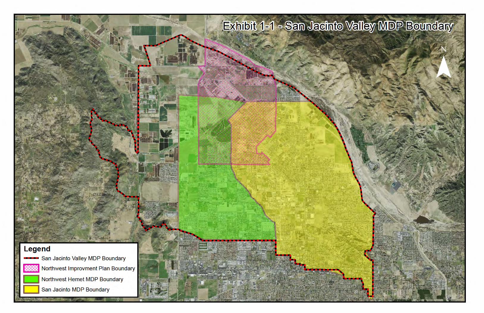
Exhibit 1-1 – San Jacinto Valley MDP Boundary Exhibit 1-2 – San Jacinto Valley MDP Subareas
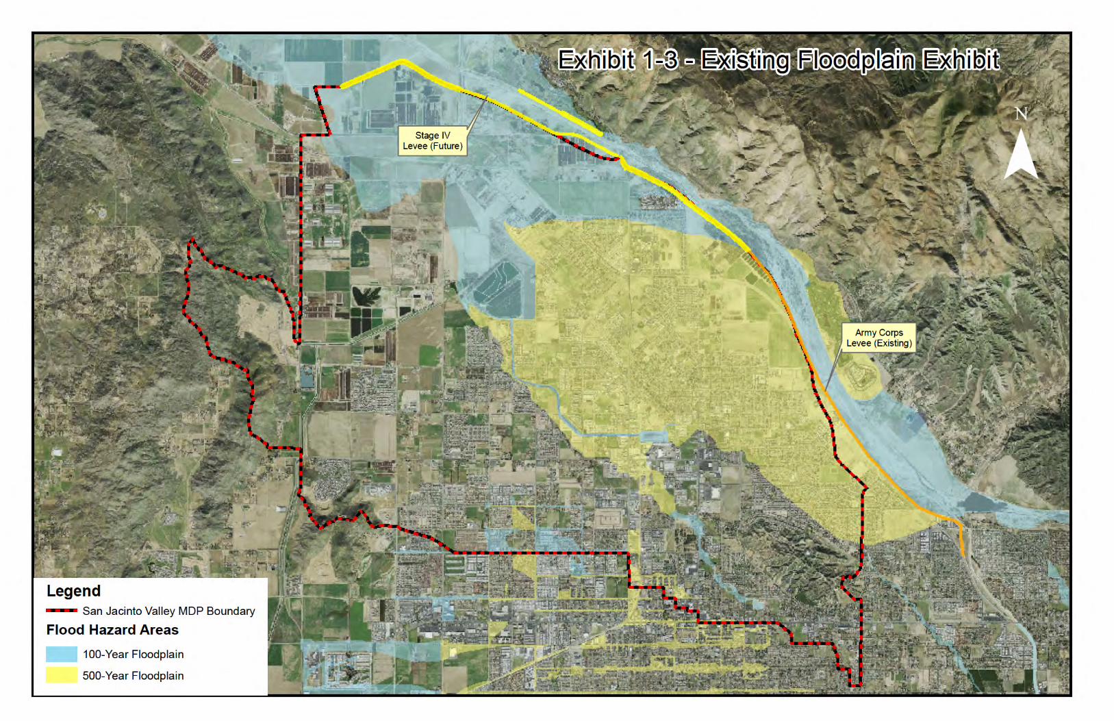
Exhibit 1-3 – San Jacinto Valley MDP Existing FEMA Floodplain Exhibit 4-1 – San Jacinto Valley Rainfall
APPENDIX A
Eastern Municipal Water District Resolution No. 5073
MAP Master Drainage Plan Maps ................................................................................ Inside Back Cover

- 1 -
SECTION I – EXECUTIVE SUMMARY
OVERVIEW
The San Jacinto Valley Master Drainage Plan (Plan) encompasses portions of unincorporated Riverside County and portions of the Cities of San Jacinto and Hemet. The Plan is roughly bounded by the San Jacinto River to the north, Florida Avenue to the south, Meridian Street to the east, and Warren Road to the west. The Plan area includes all of the existing San Jacinto Master Drainage Plan (MDP) area, which was originally adopted in January 1982 and revised July 1990. The Plan also includes the Northwest Hemet MDP area, which was adopted in January 1985. Additionally, the Plan encompasses the vast majority of San Jacinto's Northwest Improvement Plan which was adopted in May 1991. Finally, the Plan includes drainage facilities for areas located to the north and west of the San Jacinto and Northwest Hemet MDPs. Exhibit 1-1 shows the boundaries for the Plan, the Northwest Hemet MDP, the San Jacinto MDP, and the Northwest Improvement Plan. The Plan was studied in three subareas, the "North Area", the "West Area" and the "City Area". The "North Area" includes the area north of Ramona Expressway and west of State Street. The "West Area" includes the area south of Ramona Expressway and west of Sanderson Avenue. The remainder is the "City Area". Exhibit 1-2 shows the boundaries for the subareas within the Plan's drainage boundary. Generally speaking, the North and West Areas cover areas that were not previously included in either the San Jacinto Area MDP or the Northwest Hemet MDP. These areas had previously been considered as agricultural lands but, due to changes in local land-use policies, are now considered as single-family residential and commercial land use areas. A drainage plan needed to be developed for the North and West Areas. At the same time, revisions and updates were necessary for the existing Northwest Hemet and San Jacinto MDPs. Rather than creating a new MDP and separately updating the San Jacinto and Northwest Hemet MDPs, it was decided to combine all three areas into one comprehensive MDP. Therefore, upon adoption, the Plan will supersede the Northwest Hemet and San Jacinto MDPs. The Plan will also supersede the Master Drainage Plan element of the Northwest Improvement Plan. The San Jacinto River travels along the northerly part of the valley and conveys substantial stormwater runoff from regional precipitation events. Historically, the San Jacinto Valley has experienced substantial flooding from the San Jacinto River. To alleviate the flood risk, the United States Army Corps of Engineers constructed a levee along the southerly edge of the San Jacinto River from the Bautista Creek Channel downstream to approximately the intersection of Alessandro Avenue and the Ramona Expressway (near the westerly side of the Eastern Municipal Water District (EMWD) Recharge Ponds). The San Jacinto River Levee protects much of the developed area of San Jacinto from regional San Jacinto River flooding. Downstream of the levee, an earthen berm exists along the southerly "bank" of the San Jacinto River. While this berm contains runoff from minor storm events, it has neither the capacity nor the structural integrity to contain moderate to major flood flows. Accordingly, much of the northerly area within the City of San Jacinto is designated as a Special Flood Hazard Area (SFHA) on the currently effective Flood Insurance (FIRM) panel (see Figure 1-3). To reduce the risk of regional San Jacinto River flooding downstream (northerly) of the existing San Jacinto River Levee, the City of San Jacinto and the District are jointly planning the "San Jacinto River Stage IV Levee" project. This new levee segment begins at the northerly termination of the

- 2 -
existing San Jacinto levee and runs in a northerly direction past Sanderson Avenue as depicted in Figure 1-3. Once constructed, the Stage IV Levee project will reduce the threat of regional flooding downstream of the existing San Jacinto River Levee; however, portions of the "North Area" and "West Area" would still subject to local flooding. The proposed construction of MDP facilities in the "North Area" and "West Area" will address the local flooding and drainage in these areas.
PURPOSE
The purpose of this report is to identify an integrated network of drainage facilities that will alleviate both known and anticipated drainage problems within the San Jacinto Valley area. The Plan presented herein provides an effective and economical approach to providing flood protection and drainage to the area and may be used to guide construction scheduling of the principal drainage facilities. The Plan will also serve as a guide for locating and sizing local critical drainage facilities necessary to support orderly development within the area. Readers of this report should bear in mind that the drainage network described herein is conceptual in nature. Simply stated, the Plan provides a conceptual solution that addresses drainage problems within the San Jacinto Valley area based on various engineering, environmental, and economic considerations. By no means does the Plan represent the only feasible solution.
The alignment and location of the facilities proposed in this Master Drainage Plan are general. Precise facility locations will be dictated by conditions and other factors existing at the time of design. Similarly, the facility sizing information shown on the enclosed map is preliminary. More detailed analysis performed at the design stage will determine final facility sizing.
FACILITY SIZING
The storm drain facilities included in the Plan are sized for either the 10-year or 100-year (recurrence interval) storm event. Nearly all facilities in the North and West Areas are 100-year facilities. The MDP map exhibit indicates whether a particular facility is sized for the 10-year or 100-year storm event.
SCOPE
The area covered by this Plan consists of approximately 27.4 square miles, ranging from flat valley terrain to foothills with steep slopes. Tasks involved in the development of the Plan include:
1. Determination of the points of concentration and quantity of storm runoff at various locations.
2. Determination of the location and size of proposed drainage facilities. 3. Investigation of alternative routes and conveyance methods as a basis for selecting the
most economical, environmental, and soundly engineered plan. 4. Preparation of a drainage facility map. 5. Preparation of preliminary facility plan and profile sheets. 6. Preparation of facility cost estimates.
- 3 -
ALTERNATIVES/REFINEMENTS
Because the North and West Areas had not been previously included in an MDP, the development of this Plan involved an extensive analysis of alternative drainage networks for these two areas. Various facility types and alignments were analyzed. The engineering feasibility, economic cost, and environmental impact of the facilities were all considered when analyzing each alternative. A more detailed discussion of the alternatives for the North and West Areas can be found in Section V of this report. The San Jacinto and Northwest Hemet MDPs had previously established proposed drainage facilities for the City Area. Therefore, extensive alternatives analysis was not necessary within the City Area. Nevertheless, some modifications and refinements to the San Jacinto and Northwest Hemet MDPs were made to accommodate existing development and address existing drainage concerns.
NAMING CONVENTION Due to the consolidation of the San Jacinto and Northwest Hemet MDPs, there were instances where certain facility names would be duplicated under the new MDP. To resolve this issue, all San Jacinto MDP facility names will remain the same, with the exception that the facility name will be preceded by San Jacinto Valley MDP instead of San Jacinto MDP. All Northwest Hemet MDP facilities will also be preceded by San Jacinto Valley MDP, but in addition will be preceded by an "N" for Northwest Hemet. For example, Northwest Hemet MDP Line D is now named San Jacinto Valley MDP N Line D, while San Jacinto MDP Line D is now to be called San Jacinto Valley MDP Line D.
COSTS
Cost estimates for the San Jacinto Valley MDP facilities were prepared using Riverside County Flood Control and Water Conservation District's 2011 Planning Cost Worksheets. The estimated cost for the construction of the MDP facilities presented in this report is shown in Table 8.1.
RECOMMENDATIONS
It is recommended that:
1. The Riverside County Flood Control and Water Conservation District's Board of
Supervisors, the City of Hemet and the City of San Jacinto each adopt the San Jacinto Valley Master Drainage Plan, as set forth herein.
2. The San Jacinto Valley Master Drainage Plan, as set forth herein, be used as a guide for all future developments within the study area and that such developments be required to conform to the Plan insofar as possible.
3. The rights-of-way necessary for construction of the San Jacinto Valley Master Drainage Plan facilities be protected from encroachment.

- 4 -
SECTION II – DATA COLLECTION EFFORTS Several sources of data were used to prepare the San Jacinto Valley Master Drainage Plan. A description of the data collection efforts is listed below: Topography – Topography and planimetric data was obtained from the Riverside County Flood Control and Water Conservation District. The four foot contour interval topography is from the District's Orthophoto Topography maps. The coordinate system for the topography is the North American Datum 1983 State Plane California VI horizontal projection. The topography elevation is based on the North American Vertical Datum of 1929. San Jacinto MDP - Backup information consisting of hydrology work maps, hydrology and hydraulic calculations, cost estimates, MDP Plan and Profile Drawings, and the MDP report were obtained from the District for the San Jacinto MDP. The San Jacinto MDP was originally adopted in January 1982 and was revised July 1990.
Northwest Hemet MDP - Backup information consisting of hydrology work maps, hydrology and hydraulic calculations, cost estimates, MDP Plan and Profile Drawings, and the MDP report were obtained from the District. The Northwest Hemet MDP was originally adopted in January 1985.
Northwest Improvement Plan – A copy of the City of San Jacinto Northwest Improvement Plan prepared by NBS Lowry was provided by the City of San Jacinto. This 1991 report included circulation elements and storm drain alignments previously contemplated in the undeveloped northwest portion of the City. Rainfall Data – There are three sets of Rainfall Data utilized in this study. Two versions of NOAA 2 are used for analyzing areas tributary to existing facilities proposed in the San Jacinto and Northwest Hemet MDPs. NOAA-14 rainfall values were used for analyzing areas tributary to new facilities. See Section IV for additional information. Soils Data – Two sources of Soils Data were used in preparation of the Plan. The SCS Hydrologic Soils Group Maps in the Districts' Hydrology Manual were used for hydrology calculations for all facilities upstream of MDP facilities that have been constructed. NRCS Soil Survey Geographic (SSURGO) soil information was used to size all new or revised facilities in the Plan. Land Use - Certain facilities within the current Plan are carryovers from the District's San Jacinto and Northwest Hemet MDPs. Specifically, the facilities include San Jacinto MDP Lines A, A-1, A-2, A-3, B, B-1, C, C-4, C-5, D, D-3, D-4, E-1, E-2, E-2A, E-3, H, H-1, J, J-1 and J-2, and within the Northwest Hemet MDP, Lines B, B-2, B-2, B-3, B-4 and B-5. The hydrology calculations for the San Jacinto MDP were based on "The Hemet-San Jacinto Area General Plan" and the calculations for the Northwest Hemet MDP are based on the Riverside County "Comprehensive General Plan (1984)". The calculations for all other facilities within the Plan are based on the General Plans for the City of San Jacinto (2006), the City of Hemet (2006), and the County of Riverside (2003). Ultimate land at build out use was assumed for all hydrology calculations. Circulation Elements – The City of San Jacinto provided copies of proposed circulation elements for the City. Additionally, the City provided the "preferred alignments" of Highway 79 and the Mid County Parkway.

- 5 -
Existing Drainage Facilities - Copies of all available construction drawings for existing MDP and other drainage facilities were obtained from the City of San Jacinto and the District. Existing MDP facilities are discussed in more detail in Section III of this report. MWD Utilities – The Metropolitan Water District of Southern California (MWD) has several large facilities that traverse the San Jacinto Valley. MWD provided copies of the "As-Built" improvement plans for the facilities in the Valley. Additionally, RBF Consulting provided pothole data of MWD's Colorado River Aqueduct at the Line Z crossing location.
Site Specific Hydrology Reports - The following site specific hydrology reports were obtained as backup to the San Jacinto Valley MDP:
The Cove @ San Jacinto (Tracts 30033, 30034, 30035, 30036 & 30084) Detention Basin Design Report Synthetic Unit Hydrograph – Prepared by SB&O, Inc. – March 7, 2004 – Stage/Storage – Outlet/Rating curves for the "Cove" detention basins were obtained from this report.
Hydraulic Analysis of Existing Flood Control Systems in Rancho San Jacinto – Prepared by Engineering Resources of Southern California, Inc. – August 20, 2002
Hydrology Report for Tract 29917 – Prepared by Engineering Resources of Southern California, Inc. – November 2003
Preliminary Hydrology Analysis for Tentative Tract 30598 – Prepared by Hunsaker & Associates – December 8, 2003
Drainage Study for Lyon Avenue Detention Basin – Prepared by Albert A. Webb Associates – May 2006
Offsite Hydrology and Hydraulic Calculations for Tracts 31037, -1, -2 & -3 - Prepared by CSL Engineering, Inc. - March 2004
Hydrology Analysis for Western Village Master Drainage Plan – Line J – Prepared by Stantec Consulting, Inc. – October 2008
Planning and CEQA Document - The following site specific planning reports and CEQA Documents were obtained as backup to the San Jacinto Valley MDP:
Draft Environmental Impact Report – Villages of San Jacinto - Prepared by Dudek – April 2006
Esplanade Draft Specific Plan Report - Prepared by AEI CASC Engineering – September 2005
Preliminary Draft No. 3 – Proposed Mitigated Negative Declaration For Line E Amendment to the Northwest Hemet Master Drainage Plan and the Northwest Improvement Plan - Prepared by PZL, Inc.– August 2007

- 6 -
SECTION III – EXISTING CONDITIONS
CURRENT DRAINAGE PATTERNS
The City of San Jacinto is impacted by both regional and local flooding. The San Jacinto River travels along the northerly part of the valley and conveys substantial stormwater runoff from regional precipitation events. Historically, the San Jacinto Valley has experienced substantial flooding from the San Jacinto River. To alleviate the flood risk, the United States Army Corps of Engineers constructed a levee along the southerly edge of the San Jacinto River from the Bautista Creek Channel downstream to approximately the intersection of Alessandro Avenue and the Ramona Expressway (near the westerly side of the EMWD Recharge Ponds). The San Jacinto River Levee protects much of the developed area of San Jacinto from regional San Jacinto River flooding. Downstream of the levee, an earthen berm exists along the southerly "bank" of the San Jacinto River. While this berm contains runoff from minor storm events, it has neither the capacity nor the structural integrity to contain moderate to major flood flows. Accordingly, much of the northerly area within the City of San Jacinto is designated as a Special Flood Hazard Area (SFHA) on the currently effective Flood Insurance (FIRM) panel (see Figure 1-3). To reduce the risk of regional San Jacinto River flooding downstream (northerly) of the existing San Jacinto River Levee, the City of San Jacinto and the District are jointly planning the "San Jacinto River Stage IV Levee" project. This new levee segment begins at the northerly termination of the existing San Jacinto Levee and runs in a northerly direction past Sanderson Avenue. Once constructed, the Stage IV Levee project will reduce the threat of regional flooding downstream of the existing San Jacinto River Levee; however, portions of the "North Area" and "West Area" would still be subject to local flooding. The proposed construction of MDP facilities in the "North Area" and "West Area" will address the local flooding and drainage in these areas. Local runoff travels from the southeasterly side of the valley to the northwesterly side of the valley. In general, flows begin in the northerly portion of the City of Hemet and flow in a northwesterly direction through the City of San Jacinto toward the San Jacinto River. Much of the drainage in the southeasterly portion of San Jacinto is conveyed by existing MDP facilities. San Jacinto MDP Lines C and D convey runoff to the Buena Vista Detention Basin. Outflows from the Buena Vista Detention Basin are conveyed by San Jacinto MDP Line E to the San Jacinto Reservoir which is owned and operated by Eastern Municipal Water District1. Outflows from the San Jacinto Reservoir travel in a northwesterly direction toward the San Jacinto River. Exhibit 1-3 shows the existing FEMA Special Flood Hazard Area that impacts much of the North area and portions of the West areas.
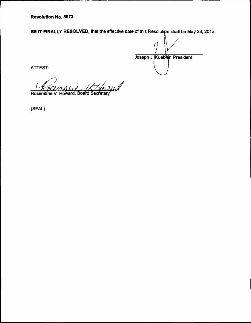
1 EMWD Resolution R-5073 5-23-2012

- 7 -
EXISTING DRAINAGE FACILITIES
The following existing drainage facilities are located within the Plan and are shown as existing facilities on the MDP exhibits:
Facility Name Drawing No. Maintenance San Jacinto Reservoir -- EMWD Buena Vista Retention Basin 4-436 District Parkhill Retention Basin 4-265, 4-270 District Tahquitz High School Basins -- Non-District San Jacinto MDP Line E 4-708 District San Jacinto MDP Line D 4-535, 4-551 District
CONSTRAINTS
The following constraints were considered in the development of the San Jacinto Valley Master Drainage Plan:
MWD's Colorado River Aqueduct - The Colorado River Aqueduct is a major MWD facility that traverses the San Jacinto Valley in an east/west direction. The Colorado River Aqueduct is relatively large in diameter and has relatively shallow cover. The large diameter of the Colorado River Aqueduct makes vertical adjustment (i.e., relocation) of the aqueduct economically unfeasible.
MWD's San Jacinto Pipeline and Casa Loma Siphon – The San Jacinto Pipeline and the
Casa Loma Siphon are also major MWD facilities. They traverse the San Jacinto Valley in a north/south direction. As with the Colorado River Aqueduct, the San Jacinto Pipeline and the Casa Loma Siphon both are relatively large pipes with relatively shallow cover.
Eastern Municipal Water District's Hemet/San Jacinto Regional Water Reclamation
Facility – The alignment of the proposed Northwest Hemet MDP Line D would bisect EMWD's existing water reclamation facility. This master plan realigns Northwest Hemet MDP Line D, (now named "San Jacinto Valley MDP N Line D"), around the EMWD Plant.
Interim Development without San Jacinto River Stage IV Levee – Several MDP lines will not fully function prior to the construction of the proposed San Jacinto River Stage IV Levee. Line E (downstream of Sanderson Avenue), Line V, Line H, Line 1 Line 2, Line 3, Line 4, Line 5, Line 6 and Lateral 4-A are all dependent upon the Levee. Should these facilities be constructed prior to the construction of the Stage IV Levee, an analysis to determine the facilities' level of functionality will need to be undertaken.
San Jacinto Reservoir – As part of this study, the capacity, flow attenuation, and spillway
location of EMWD's San Jacinto Reservoir were determined. The reservoir impacts the location and size of Line E downstream of the reservoir as well as Line Z.
San Jacinto River – Hydraulic Impact - Several MDP facilities outlet into the San Jacinto
River through the proposed San Jacinto River Stage IV Levee. The backwater effects caused by the connection to the river impact the upstream design of the proposed drainage facilities. These impacts have been accounted for in the MDP design.

- 8 -
Approved Tentative Tract Maps – MDP facility alignment considered Tentative Maps previously approved by the City. MDP facilities avoided dividing parcels located within the proposed subdivisions.
Future Alignments: Highway 79 and Mid-County Parkway – The proposed alignments for
Highway 79 and Mid-County Parkway were taken into account. MDP facilities were designed such that they did not significantly conflict with or preclude the City adopted alignments for Highway 79 and the Mid-County Parkway.

- 9 -
SECTION IV – HYDROLOGY
METHODOLOGY
The hydrology for the Plan was developed using two different methods: the Modified Rational Method and the Synthetic Unit Hydrograph Method. The Modified Rational Method was used to determine the peak discharges generated from smaller watersheds (generally less than 300 to 500 acres in size). The Synthetic Unit Hydrograph Method was used for larger watershed areas to generate the peak discharge rates for sizing major drainage facilities and to perform routing calculations for the proposed detention basins. Methodology and supportive data for the rational and synthetic hydrology may be found in the "Riverside County Flood Control and Water Conservation District Hydrology Manual" (April 1978).
RAINFALL DATA / FACILITY SIZING
Rainfall data, and the impacts to existing and future facilities, were considered as part of the MDP update. The rainfall data contained in the District's Hydrology Manual is based on NOAA Atlas II rainfall. The hydrology calculations for the San Jacinto and the Northwest Hemet MDPs utilize the NOAA Atlas II data, with adjustments to match local precipitation gauge data available at the time the studies were performed. All facilities constructed prior to 2006 were sized based on NOAA Atlas II data. In 2006, the Hydrology Standards for the Plan were established. Rainfall data was based on NOAA Atlas 14 Volume 1 Version 4.0, the most current data available at the time. Within the Plan Area, NOAA Atlas 14 rainfall values are higher than the earlier NOAA Atlas II rainfall values. Consequently, the existing facilities do not have capacity to convey the "additional flow" generated by using the NOAA Atlas 14 rainfall values. Accordingly, if new facilities located upstream of existing facilities were sized using NOAA Atlas 14 rainfall values, the downstream facilities would either need to be modified to increase their conveyance capacity or detention basins would be required upstream of each existing facility to reduce peak flows to match the conveyance capacity of the existing downstream facilities. The cost of retrofitting existing facilities, compared to the additional flood protection they would provide, was deemed to be excessive. The construction of detention basins upstream of existing drainage facilities also proved to be problematic since much of the area is already developed and there is very limited space available in which to construct new basins. Therefore, it was determined that NOAA Atlas II rainfall data would be used to size those facilities located upstream of an existing MDP facility and NOAA Atlas 14 rainfall data would be used to size all new MDP facilities and downstream extensions of any existing MDP facilities. Table 4-1 lists the modified point rainfall values used in the development of the San Jacinto and Northwest Hemet MDPs. In the updated Plan where proposed facilities are i) located upstream of existing facilities (i.e. NOAA Atlas II Rainfall) and ii) maintain the same alignment as the original San Jacinto or Northwest Hemet MDPs, the modified NOAA Atlas II rainfall data is used. Table 4-2 contains the unmodified NOAA Atlas II rainfall data. In the updated Plan where proposed facilities are both upstream of existing facilities (i.e., NOAA Atlas II Rainfall) and new alignments are proposed, the unmodified NOAA Atlas II rainfall data is used. Table 4-3 contains the NOAA Atlas 14 Rainfall Values. These values are used downstream of existing facilities. Exhibit 4-1 shows where the various rainfall data is used within the Plan.

- 10 -
Table 4-1 – Modified NOAA Atlas II Rainfall Depths
from the Original San Jacinto MDP and Northwest Hemet MDP Point Rainfall Values Event 10-year 100-year
1-Hour 0.68" 1.06" 3-Hour 1.16" 1.82" 6-Hour 1.71" 2.68" 24-Hour 3.03" 4.75"
Slope of Intensity curve = 0.5
Table 4-2 – NOAA Atlas II Standard Intensities for Updated MDP Facilities Event 10-year 100-year
1-Hour 0.81" 1.2" Slope of Intensity curve = 0.5
Table 4-3 – NOAA Atlas 14 Point Rainfall Values Event NOAA 14
100-Year 1-Hour 1.65" 100-Year 3-Hour 2.35" 100-Year 6-Hour 3.30" 100-Year 24-Hour 5.66"
Slope of Intensity Curve = 0.6
SOIL TYPE DATA
Two sources of soil type data were used for hydrology calculations. For those areas that utilized NOAA 2 rainfall data, NRCS soil type data published in the Hydrology Manual was used. For those areas that utilized NOAA 14 rainfall data, updated NRCS SSURGO GIS soil type data was used. Soil type exhibits are contained in the San Jacinto Valley MDP Hydrology Reports.
LAND USE / PERCENT IMPERVIOUS
Certain facilities within the current Plan are carryovers from the District's San Jacinto and Northwest Hemet MDPs. Specifically, the facilities include San Jacinto MDP Lines A, A-1, A-2, A-3, B, B-1, C, C-4, C-5, D, D-3, D-4, E-1, E-2, E-2A, E-3, H, H-1, J, J-1 and J-2 and within the Northwest Hemet MDP Lines B, B-2, B-2, B-3, B-4 and B-5. The hydrology calculations for the San Jacinto MDP were based on "The Hemet-San Jacinto Area General Plan" and the calculations for the Northwest Hemet MDP are based on the Riverside County "Comprehensive General Plan (1984)". The calculations for all other facilities within the Plan are based on the General Plans for the City of San Jacinto (2006), the City of Hemet (2006), and the County of Riverside (2003). Ultimate land at build out use was assumed for all hydrology calculations. Land use designations for the San Jacinto Valley MDP were translated to impervious percentage as shown below. In general, land designated as High Density Residential or Very High Density Residential was classified as Apartments. Land use designated as Community Commercial, Downtown Commercial, or Light Industrial was classified as Commercial/Industrial in the Plan. Land use designated as Medium Density Residential, Low Density Residential, Parks, and various

- 11 -
other land use designations was classified as ¼ Acre Residential in the Plan. Land use designated as Very Low Density Residential was defined as ½ Acre Residential in the Plan. Table 4.4 provides a summary of the various zoning land use designations and the resulting hydrological land use designations.
Table 4-4 – San Jacinto Valley MDP ‐ Land Use Chart
San Jacinto Valley MDP ‐ Land Use Chart
Land Use Description Abbreviation Classified as Impervious % Business Park BP commercial 90%
Community Commercial CC commercial 90% Downtown Commercial DC commercial 90%
Industrial I commercial 90% Light Industrial LI commercial 90%
High Density Residential HDR apartments 80% Very High Density
Residential VHDR apartments 80%
Low Density Residential LDR 1/4‐acre SFR 50% Low Density Transitional LDT 1/4‐acre SFR 50%
Medium Density Residential
MDR 1/4‐acre SFR 50% Parks PR 1/4‐acre SFR 50%
Public Institution P 1/4‐acre SFR 50% Very Low Density
Residential VLDR 1/2‐acre SFR 40%
Eastern Municipal Water District Land
EMWD Undeveloped 0% Hillside Hill Undeveloped 0%
Open Space OS Undeveloped 0% Rural Residential RR Undeveloped 0%
SUMMARY OF HYDROLOGY ANALYSIS
The backup hydrology and hydraulic reports prepared for the Plan are organized into three sub-areas, the North Area, the West Area and the City Area. Each of the four reports listed below contains detailed hydrologic and hydraulic information used in the development of the Plan. A summary of each report follows:
San Jacinto Valley Master Drainage Plan Update for the North Area (July 2007, Revised August 2008). Contains unit hydrograph analysis, routing studies, rational hydrology studies, hydraulic analysis, facility plan and profile sheets, and costs estimates for the North Area.
Design Hydrology Review for the San Jacinto Valley Master Drainage Plan Update for the West Area (March 2007, Revised July 2008). Contains unit hydrograph analysis for the West Area.
San Jacinto Valley Master Drainage Plan Update for the West Area (May 2007, Revised
October 2008). Contains routing studies, rational hydrology studies, hydraulic analysis, facility plan and profile sheets, and costs estimates for the West Area.
- 12 -
San Jacinto Valley Master Drainage Plan Update for the City of San Jacinto Area (September 2008, Revised April 2009, Revised July 2010). Contains rational hydrology studies, hydraulic analysis, facility plan and profile sheets, and cost estimates for the City Area.
Copies of these reports are on file at the District.

- 13 -
SECTION V – ALTERNATIVES/REFINEMENTS
OVERVIEW
As stated in the Executive Summary, both the West and the North Areas are primarily undeveloped and without a master drainage plan. Therefore, the development of this Plan entailed an extensive analysis of alternative drainage networks for these two areas. Several conceptual alternatives were initially developed for the North and the West Areas, respectively. The conceptual alternatives considered various facility types and alignments. Flows were determined using area weighted approximations from preliminary unit hydrograph flows. Facility sizes were estimated using normal depth calculations.
WEST AREA
Based upon the conceptual level analysis, "Alternative 4" was selected by both the City and the District because "Alternative 4" was the only alternative that adequately addressed Line D flows southerly of the EMWD Water Reclamation Facility. Nine variations of "Alternative 4" were then developed in order to optimize basin sizes and locations, and facility types. Facility sizes, costs and right-of-way requirements were developed for each of the nine variations. Based upon the analysis, the City and the District selected "Alternative 4.2" as the preferred alternative for the West Area.
NORTH AREA
Based upon the conceptual level analysis, six variations of the conceptual alternatives were developed in order to optimize basin sizes and locations and facility types. Facility sizes, costs and right-of-way requirements were developed for each of the six variations. Based upon the analysis, the City and the District selected "Alternative 1A" as the preferred alternative for the North Area.
CITY AREA
The San Jacinto and Northwest Hemet MDPs had previously established a drainage plan and some of the proposed drainage facilities within the two MDPs have been constructed. Additionally, as previously mentioned, existing land-use patterns limited opportunities for new detention basin facilities. Therefore, it was not necessary to perform an extensive alternatives analysis within the City Area. Nevertheless, modifications and refinements to the San Jacinto and Northwest Hemet MDPs were made to accommodate existing development and alleviate existing drainage concerns. A list of the modified facilities within the City Area is shown below. A detailed description of the facilities is contained in the Design Hydrology Review Report for the City Area, which is available from the District.
Line D-2 Extension (Hewitt Street Storm Drain) Line G Line G-1 Line G-3 Line E-4 Line E-5 Line E-6 Line H-2 N Line E-2 N Line E-2A Lyon Avenue Basin
- 14 -
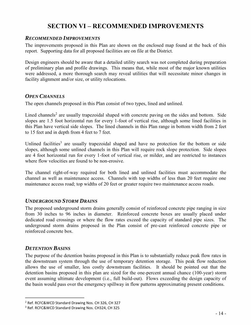
SECTION VI – RECOMMENDED IMPROVEMENTS
RECOMMENDED IMPROVEMENTS
The improvements proposed in this Plan are shown on the enclosed map found at the back of this report. Supporting data for all proposed facilities are on file at the District. Design engineers should be aware that a detailed utility search was not completed during preparation of preliminary plan and profile drawings. This means that, while most of the major known utilities were addressed, a more thorough search may reveal utilities that will necessitate minor changes in facility alignment and/or size, or utility relocations.
OPEN CHANNELS
The open channels proposed in this Plan consist of two types, lined and unlined. Lined channels2 are usually trapezoidal shaped with concrete paving on the sides and bottom. Side slopes are 1.5 foot horizontal run for every 1-foot of vertical rise, although some lined facilities in this Plan have vertical side slopes. The lined channels in this Plan range in bottom width from 2 feet to 15 feet and in depth from 4 feet to 7 feet. Unlined facilities3 are usually trapezoidal shaped and have no protection for the bottom or side slopes, although some unlined channels in this Plan will require rock slope protection. Side slopes are 4 foot horizontal run for every 1-foot of vertical rise, or milder, and are restricted to instances where flow velocities are found to be non-erosive. The channel right-of-way required for both lined and unlined facilities must accommodate the channel as well as maintenance access. Channels with top widths of less than 20 feet require one maintenance access road; top widths of 20 feet or greater require two maintenance access roads.
UNDERGROUND STORM DRAINS
The proposed underground storm drains generally consist of reinforced concrete pipe ranging in size from 30 inches to 96 inches in diameter. Reinforced concrete boxes are usually placed under dedicated road crossings or where the flow rates exceed the capacity of standard pipe sizes. The underground storm drains proposed in the Plan consist of pre-cast reinforced concrete pipe or reinforced concrete box.
DETENTION BASINS
The purpose of the detention basins proposed in this Plan is to substantially reduce peak flow rates in the downstream system through the use of temporary detention storage. This peak flow reduction allows the use of smaller, less costly downstream facilities. It should be pointed out that the detention basins proposed in this plan are sized for the one-percent annual chance (100-year) storm event assuming ultimate development (i.e., full build-out). Flows exceeding the design capacity of the basin would pass over the emergency spillway in flow patterns approximating present conditions.
2 Ref. RCFC&WCD Standard Drawing Nos. CH 326, CH 327 3 Ref. RCFC&WCD Standard Drawing Nos. CH324, CH 325

- 15 -
SECTION VII – REGIONAL WATER QUALITY FEATURES
BACKGROUND
Urban stormwater quality management has become an increasingly important aspect of drainage planning and design. The Federal Water Pollution Control Act established the National Pollutant Discharge Elimination System (NPDES) permitting program which, among other things, regulates the discharges from municipal separate storm sewer systems (MS4s). The NPDES program is administered in California by the State Water Resources Control Board. MS4 Permits are issued by Regional Water Quality Control Boards. The Plan area is located within the Santa Ana Region and is currently governed by an existing MS4 Permit of which the District and Cities of San Jacinto and Hemet are co-permittees. The current MS4 Permit requires new developments and redevelopments that exceed a certain criteria to prepare site specific Water Quality Management Plans (WQMPs). Site specific WQMPs identify site design, source control, and treatment control Best Management Practices (BMPs) that a new development project must implement on-site to minimize impacts to downstream receiving waters.
REGIONAL OPPORTUNITIES
Regional water quality opportunities were explored as part of the preparation of the San Jacinto Valley MDP. Discussions were held with the Santa Ana Regional Water Quality Control Board regarding the incorporation of regional water quality control features into the San Jacinto Valley MDP. The Regional Board was supportive of utilizing regional water quality features in conjunction with site specific features to form water quality treatment trains. The implementation of such features does not remove the requirement, stipulated by the MS4 Permit, to prepare and implement site specific WQMPs. Rather the basins will serve as additional measures to protect the beneficial uses of downstream water resources.
MDP WATER QUALITY FEATURES
The San Jacinto Valley MDP includes several elements that will help promote regional water quality. Where possible, the plan will utilize earthen channels rather than concrete lined channels. This site design BMP will promote infiltration of urban runoff. Regional detention basins will promote ground water recharge and remove trash and debris from runoff. The MDP drainage facilities, coupled with site specific BMPs, will effectively treat pollutants of concern tributary to downstream receiving water bodies.
- 16 -
SECTION VIII– COSTS
ESTIMATED COST
A cost summary for the MDP facilities is shown in TABLE 8-1 "Cost Summary". Costs were based on the 2011 Planning Unit Cost sheets and include construction, right-of-way and 40% for engineering, environmental mitigation, administration and contingencies.
- 17 -
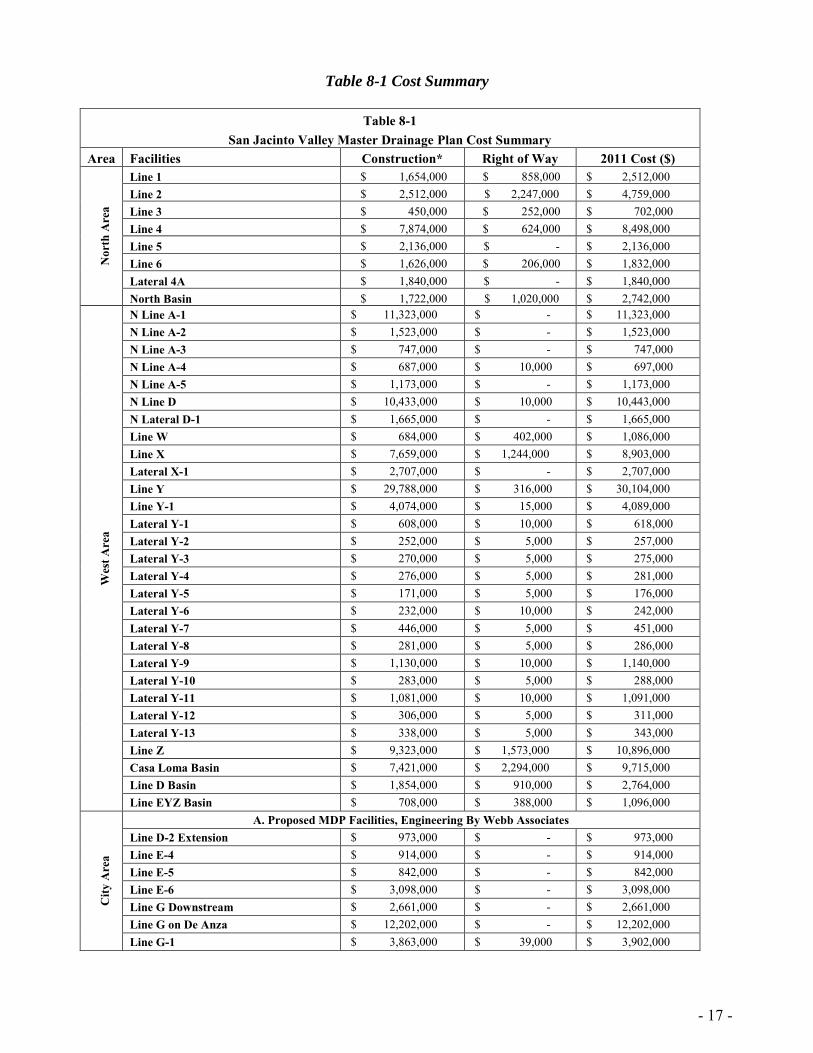
Table 8-1 Cost Summary
Table 8-1 San Jacinto Valley Master Drainage Plan Cost Summary
Area Facilities Construction* Right of Way 2011 Cost ($)
Nor
th A
rea
Line 1 $ 1,654,000 $ 858,000 $ 2,512,000 Line 2 $ 2,512,000 $ 2,247,000 $ 4,759,000 Line 3 $ 450,000 $ 252,000 $ 702,000 Line 4 $ 7,874,000 $ 624,000 $ 8,498,000 Line 5 $ 2,136,000 $ - $ 2,136,000 Line 6 $ 1,626,000 $ 206,000 $ 1,832,000 Lateral 4A $ 1,840,000 $ - $ 1,840,000 North Basin $ 1,722,000 $ 1,020,000 $ 2,742,000
Wes
t Are
a
N Line A-1 $ 11,323,000 $ - $ 11,323,000 N Line A-2 $ 1,523,000 $ - $ 1,523,000 N Line A-3 $ 747,000 $ - $ 747,000 N Line A-4 $ 687,000 $ 10,000 $ 697,000 N Line A-5 $ 1,173,000 $ - $ 1,173,000 N Line D $ 10,433,000 $ 10,000 $ 10,443,000 N Lateral D-1 $ 1,665,000 $ - $ 1,665,000 Line W $ 684,000 $ 402,000 $ 1,086,000 Line X $ 7,659,000 $ 1,244,000 $ 8,903,000 Lateral X-1 $ 2,707,000 $ - $ 2,707,000 Line Y $ 29,788,000 $ 316,000 $ 30,104,000 Line Y-1 $ 4,074,000 $ 15,000 $ 4,089,000 Lateral Y-1 $ 608,000 $ 10,000 $ 618,000 Lateral Y-2 $ 252,000 $ 5,000 $ 257,000 Lateral Y-3 $ 270,000 $ 5,000 $ 275,000 Lateral Y-4 $ 276,000 $ 5,000 $ 281,000 Lateral Y-5 $ 171,000 $ 5,000 $ 176,000 Lateral Y-6 $ 232,000 $ 10,000 $ 242,000 Lateral Y-7 $ 446,000 $ 5,000 $ 451,000 Lateral Y-8 $ 281,000 $ 5,000 $ 286,000 Lateral Y-9 $ 1,130,000 $ 10,000 $ 1,140,000 Lateral Y-10 $ 283,000 $ 5,000 $ 288,000 Lateral Y-11 $ 1,081,000 $ 10,000 $ 1,091,000 Lateral Y-12 $ 306,000 $ 5,000 $ 311,000 Lateral Y-13 $ 338,000 $ 5,000 $ 343,000 Line Z $ 9,323,000 $ 1,573,000 $ 10,896,000 Casa Loma Basin $ 7,421,000 $ 2,294,000 $ 9,715,000 Line D Basin $ 1,854,000 $ 910,000 $ 2,764,000 Line EYZ Basin $ 708,000 $ 388,000 $ 1,096,000
City
Are
a
A. Proposed MDP Facilities, Engineering By Webb Associates Line D-2 Extension $ 973,000 $ - $ 973,000 Line E-4 $ 914,000 $ - $ 914,000 Line E-5 $ 842,000 $ - $ 842,000 Line E-6 $ 3,098,000 $ - $ 3,098,000 Line G Downstream $ 2,661,000 $ - $ 2,661,000 Line G on De Anza $ 12,202,000 $ - $ 12,202,000 Line G-1 $ 3,863,000 $ 39,000 $ 3,902,000

- 18 -
Table 8-1 San Jacinto Valley Master Drainage Plan Cost Summary
Area Facilities Construction* Right of Way Total Cost C
ity A
rea
Line G-2 $ 461,000 $ - $ 461,000 Line G-3 $ 7,896,000 $ 312,000 $ 8,208,000 Line H-2 $ 995,000 $ - $ 995,000 Line J-3 $ 6,156,000 $ - $ 6,156,000 Line K $ 1,179,000 $ - $ 1,179,000 Line V $ 2,040,000 $ 1,014,000 $ 3,054,000 N Line E $ 13,114,000 $ 4,140,000 $ 17,254,000 N Line E-2 $ 6,906,000 $ 318,000 $ 7,224,000 N Line E-2A $ 534,000 $ - $ 534,000 Lyon Avenue Basin $ 614,000 $ - $ 614,000
B. Proposed MDP Facilities, Engineering By RCFC&WCD 1982 Line A $ 5,192,000 $ 108,000 $ 5,300,000 Line A-1 $ 520,000 $ - $ 520,000 Line A-2 $ 644,000 $ - $ 644,000 Line A-3 $ 405,000 $ - $ 405,000 Line B $ 2,572,000 $ 48,000 $ 2,620,000 Line B-1 $ 927,000 $ - $ 927,000 Line C $ 3,401,000 $ 378,000 $ 3,779,000 Line C-4 $ 2,631,000 $ - $ 2,631,000 Line C-5 $ 238,000 $ - $ 238,000 Line D $ 1,194,000 $ - $ 1,194,000 Line D-1 $ 781,000 $ - $ 781,000 Line D-3 $ 423,000 $ - $ 423,000 Line D-4 $ 438,000 $ - $ 438,000 Line E-1 $ 403,000 $ 54,000 $ 457,000 Line E-2 $ 4,340,000 $ - $ 4,340,000 Line E-2a $ 253,000 $ - $ 253,000 Line E-3 $ 957,000 $ 102,000 $ 1,059,000 Line H $ 3,978,000 $ 480,000 $ 4,458,000 Line H-1 $ 680,000 $ - $ 680,000 Line J south of Ramona $ 2,667,000 $ 156,000 $ 2,823,000 Line J-1 $ 834,000 $ - $ 834,000 Line J-2 $ 1,048,000 $ - $ 1,048,000 N Line B $ 1,033,000 $ 78,000 $ 1,111,000 N Line B-1 $ 3,826,000 $ - $ 3,826,000 N Line B-2 $ 1,379,000 $ - $ 1,379,000 N Line B-3 $ 1,297,000 $ - $ 1,297,000 N Line B-4 $ 656,000 $ - $ 656,000 N Line B-5 $ 583,000 $ - $ 583,000
C. Proposed MDP Facilities, Engineering By Various Engineers Line J north of Ramona $ 2,145,000 $ 492,000 $ 2,637,000
Total $ 227,150,000 $ 20,173,000 $ 247,323,000
* Includes 40% for Engineering, Administration, Contingencies & Mitigation
Values rounded to nearest thousand
- 19 -
SECTION IX – CONCLUSION AND RECOMMENDATIONS Based on the studies and investigations made for this report, the District's General Manager-Chief Engineer has determined that:
1. The San Jacinto Valley has experienced serious flooding problems in the past. As this area continues to urbanize, the risk of flood damage is expected to increase unless the flood protection and drainage facilities identified in the Plan are constructed in an orderly manner.
2. A drainage system is required to safely convey stormwater runoff through the area with
the least interruption to public services. The Plan presented in this report is such a system and is deemed the most feasible of the alternatives studied.
3. The proposed Plan lends itself to staged construction as funds become available. 4. The total cost of the recommended improvements, including construction, rights-of-way,
engineering, administration and contingencies, is estimated to be $247,323,000.
Therefore, it is recommended that:
1. The Master Drainage Plan, as set forth herein, be adopted by the Riverside County Flood
Control and Water Conservation District's Board of Supervisors and by the Cities of Hemet and San Jacinto.
2. The Master Drainage Plan, as set forth herein, be used as a guide for all future
developments in the study area and that such developments be required to conform to the Plan insofar as possible.
3. The rights-of-way necessary for construction the Plan's facilities be protected from
encroachment.


APPENDIX A Eastern Municipal Water District
Resolution No. 5073