maryland historical trust nr eligible: yes …closure in 1972, the glenwood country club served as a...
TRANSCRIPT
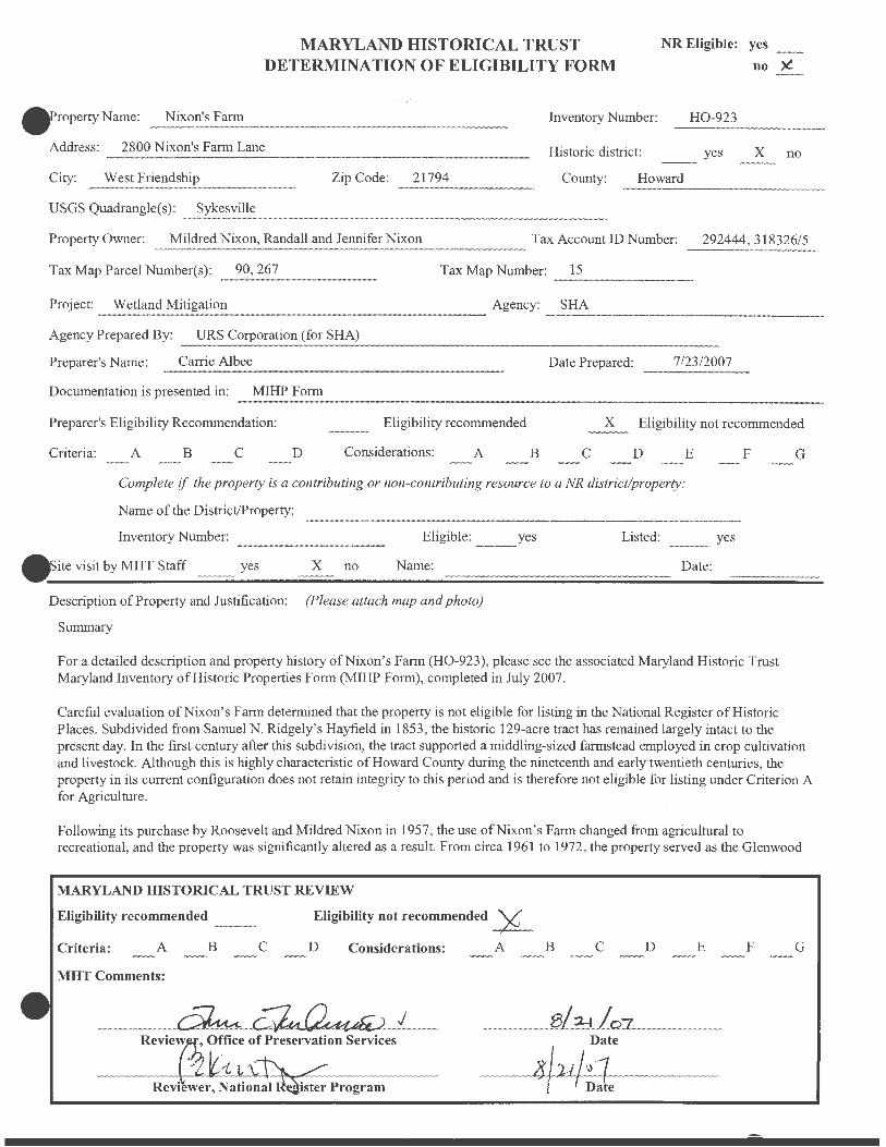
roperty Name: Nixon's Fann
MARYLAND HISTORICAL TRUST DETERMINATION OF ELIGIBILITY FORM
·' Inventory Number:
NR Eligible: yes
no :X.
H0-923
Address: 2800 Nixon's Farm Lane Historic district: yes X no
City: West Friendship Zip Code: 21794 County: Howard
USGS Quadrangle(s) : Sykesville ~~~~~~~~~~~~~~~~~~~~~~~~~~-
Property Owner: Mildred Nixon, Randall and Jennifer Nixon Tax Account ID Number: 292444, 318326/5
Tax Map Parcel Number(s): 90,267 Tax Map Number: 15 ~~~~~~~~-
Project: Wetland Mitigation Agency: SHA
Agency Prepared By: URS Corporation (for SHA)
Preparer's Name: Carrie Albee Date Prepared: 7/23/2007
Documentation is presented in: MIHPForm
Preparer's Eligibility Recommendation: Eligibility recommended x Eligibility not recommended
Criteria: A B c D Considerations: A B c D E
Complete if the property is a contributing or non-contributing resource to a NR district/property:
Name of the District/Property:
Inventory Number: Eligible:
ite visit by MHT Staff yes X no Name:
Description of Property and Justification: (Please attach map and photo)
Summary
yes Listed:
Date:
F
yes
For a detailed description and property history of Nixon's Farm (H0-923), please see the associated Maryland Historic Trust Maryland Inventory of Historic Properties Form (MIHP Form), completed in July 2007.
G
Careful evaluation of Nixon's Farm determined that the property is not eligible for listing in the National Register of Historic Places. Subdivided from Samuel N. Ridgely's Hayfield in 1853, the historic 129-acre tract has remained largely intact to the present day. In the first century after this subdivision, the tract supported a middling-sized farmstead employed in crop cultivation and livestock. Although this is highly characteristic of Howard County during the nineteenth and early twentieth centuries, the property in its current configuration does not retain integrity to this period and is therefore not eligible for listing under Criterion A for Agriculture.
Following its purchase by Roosevelt and Mildred Nixon in 1957, the use of Nixon's Farm changed from agricultural to recreational, and the property was significantly altered as a result. From circa 1961 to 1972, the property served as the Glenwood
MARYLAND HISTORICAL TRUST REVIEW
Eligibility recommended Eligibility not recommended -¥-Criteria: A B c D Considerations: A B c D E F G
MHT Comments:
Date
4uL•1 f Date
NR-ELIGIBILITY REVIEW FORM
H0-923 Nixon's Farm
Page 2
Country Club, whose membership drew principally from the young African-American professional class of Baltimore. Events held at the Glenwood Country Club included political gatherings attended by prominent figures including six Maryland governors. In 1960, Mildred Nixon retained Baltimore architect Seymour Tatar to design her residence at on the property. Completed in 1963, the Mildred Nixon House is an intact and creative example of a Modern-style Ranch dwelling of the period. While notable, the social and architectural significance of Nixon's Farm achieved in the last fifty years is not exceptional, and the property is not eligible for listing under Criterion Consideration G, either for significance under Criterion A for Ethnic Heritage and Social History, or under Criterion B for its association with Roosevelt and Mildred Nixon, or under Criterion C as an example of Modern Architecture.
Concurrent with the preparation of this evaluation and associated MIHP Form, a Phase I arc~eological investigation and evaluation of a defined portion of the Nixon's Farm property was undertaken. The summary report, entitled Phase I Archeological Survey of the Proposed Nixon's Farm Wetland Mitigation Site (Project No. H0389B21) and Phase II Evaluation of Site 18H0261 (Project No. H0756A22), Howard County, Maryland, found that none of the sites identified in the study were eligible for the National Register of Historic Places under Criterion D.
Criterion A: Agriculture
The approximately 129-acre tract that comprises Nixon's Farm has remained intact since its original subdivision of Samuel N. Ridgely' s Hayfield in 1853. In the century and a half since the subdivision, the longest use of the property has been for traditional agricultural purposes, spanning the period from 1853 to 1957. During this period, the land supported livestock including horses, cows, and pigs, and the cultivation ofrelated crops including corn and wheat. The 129-acre middling-sized farm was the livelihood of its residents who worked the land themselves and derived their principle existence from it. As such, Nixon's Farm was highly representative of the agricultural history and rural character of Howard County during the and much of the twentieth centuries. Since the mid-twentieth century, the landscape of Howard County has been rapidly shifting from rural and agricultural to suburban and residential related to the nearby metropolitan centers of Baltimore and Washington, D.C. Nixon's Farm is one of a fastdiminishing number of large, open tracts in the county.
During the Nixon ownership since 1957, however, the use of the tract has shifted from agricultural to recreational, and correspondingly, altering the character of the property, as well. Although the property remains open land with few buildings thereon, the land no longer supports either crops or livestock. The natural landscape has been significantly modified with the planting of thousands of trees for aesthetic and recreational purposes, and the addition of such recreational facilities as ball fields, gaming courts, picnic areas, and a large pond. Almost all of the buildings that had existed on the site during the use of the property as a working farm are no longer extant or lack integrity: the farmhouse used by the Arringtons was razed in 1958; the nineteenthcentury bank barn, now the Event Hall, has been radically altered; and ancillary agricultural outbuildings have either been removed or lie in ruins. For these reasons, Nixon's Farm in its current condition is not reflective of its agricultural history and is, therefore, not eligible for listing in the National Register of Historic Places under Criterion A for Agriculture.
Criterion A: Ethnic Heritage/Social History
In the early 1960s, Roosevelt and Mildred Nixon established the Glenwood Country Club on their 129-acre property in West Friendship. Named for the nearby community of Glenwood to the west, the formal incorporation of the Glenwood Country Club as a for-profit, membership organization was a natural evolution for the property, which had become a popular destination for friends and children from the Nixon's social circle in Baltimore since their purchase of the farm in 1957. For the next decade until its closure in 1972, the Glenwood Country Club served as a recreational facility and rural retreat for primarily African-American families from Baltimore seeking refuge from the hot and congested city summers. During the period, the club was the location for
MARYLAND HISTORICAL TRUST REVIEW
Eligibility recommended Eligibility not recommended
Criteria: A B c D Considerations: A B c D E F G
MHT Comments:
Reviewer, Office of Preservation Services Date
Reviewer, National Register Program Date
NR-ELIGIBILITY REVIEW FORM
H0-923 Nixon's Farm
Page 3
social and events attended by members of the African-American elite of Baltimore and political figures seeking favor with the membership, which intersected with the Small Businessman's League of Baltimore, founded by Roosevelt Nixon.
Among the visitors to the Glenwood Country Club were prominent African Americans including Aris T. Allen, member of the Maryland State Legislature, and tennis professional Althea Gibson. Also visitors to the Glenwood Country Club were six Maryland governors, Theodore McKeldin, Spiro Agnew, Marvin Mandel, Blair Lee, Harry Hughes, and William Donald Schaefer. The Glenwood Country Club also served as the location for team events of the Baltimore Colts, with Johnny Unitas, Don Shula, and others in attendance.
Since the closure of the Glenwood Country Club in 1972, substantial changes have been made to the recreational facilities. In particular, the three most significant built resources of the Glenwood Country Club, have been altered: in 1981 , the swimming pool was filled in and is no longer extant; in 1999, the Event Hall was renovated and a kitchen addition built; and in 2004, a new Picnic Pavilion was constructed following the destruction of the original building in a storm. Other elements, such as the driving range and fishing pond are no longer maintained for recreational use .
During the period of the Glenwood Country Club from circa 1961 through 1972, Nixon's Farm provided a rural recreational venue to the African-American community of Baltimore, which was discouraged, if not outright prevented, from joining similar establishments serving the white community. Although interesting and valuable, this association does not constitute exceptional importance as required for eligibility under Criterion Consideration G for properties that have achieved significance within the last fifty years. Established concurrently with the desegregation of both public and private institutions in Baltimore and the region, the Glenwood Country Club is not associated with the advances of the Civil Rights Era, nor is it exceptional within the context of African-American social venues during the period. Having served as the site of social and political events attended by prominent individuals, while notable, is not unique to this site, nor is it sufficient to support exceptional importance. For these reasons, Nixon's Farm does not possess exceptional importance and is, therefore, not eligible for listing in the National Register of Historic Places under Criterion A for Ethnic Heritage or Social History.
Criterion B: Roosevelt and Mildred Nixon
Nixon's Farm has been in the ownership of the Nixon family since its purchase by Roosevelt and Mildred Nixon in 1957. Until his death in 1972, Roosevelt Nixon was a businessman and entrepreneur of note in the African-American community of Baltimore, and the proprietor of the Glenwood County Club. Mildred Nixon, a successful real estate investor and principal operator of Nixon's Farm during its past and current use as a recreational facility, is well-known individual in Howard County. The association of the property with the Nixons does not constitute exceptional importance as required for eligibility under Criterion Consideration G. Roosevelt and Mildred Nixon are not known to be individually and exceptionally significant within the context of the AfricanAmerican community of Baltimore or within Howard County.
Criterion C: Architecture
The Mildred Nixon House, completed in 1963, was designed by Baltimore architect Seymour Tatar for Mildred Nixon, wife of a prominent African-American businessman. Featured in Better Homes and Gardens Home Building Ideas 1967, the house incorporates novel design features and materials that achieved the patron's desire for light, intimacy, and a feeling of protection while illustrating the Modem aesthetic and philosophy. Many of the original interior furnishings, selected by Frederick Miller and typical of the period, have been retained in the house. As originally executed, the landscape represented an early work of notable Washington, D.C. , landscape architect Wolfgang Oehme. The original design, however, has been significantly and repeatedly altered during the occupation of the house.
MARYLAND HISTORICAL TRUST REVIEW
Eligibility recommended Eligibility not recommended
Criteria: A B c D Considerations: A B c D E F G
MHT Comments:
Reviewer, Office of Preservation Services Date
Reviewer, National Register Program Date
NR-ELIGIBILITY REVIEW FORM
H0-923 Nixon's Farm
Page4
Although an interesting and largely intact example of an architect-designed Modern-style Ranch dwelling of the period, the Mildred Nixon House does not possess exceptional importance required to be eligible for listing in the National Register of Historic Places under Criterion Consideration G for properties that have achieved significance within the last fifty years. While compelling and creative, the design of the dwelling is not known to possess exceptional importance within the context of Howard County or regional architecture. The architect, Seymour Tatar, later of the firm of Tatar & Kelly, is not known to be particularly significant or prolific in the region. The landscape design, of potential significance as an early work of master landscape architect Wolfgang Oehme, is not longer intact. The Mildred Nixon House is, therefore, not eligible for listing in the National Register of Historic Places under Criterion C for Architecture at this time. The dwelling should, however, be re-evaluated upon reaching fifty years of age in 2013 .
MARYLAND HISTORICAL TRUST REVIEW
Eligibility recommended Eligibility not recommended
Criteria: A B c D Considerations: A B c D E F G
MHT Comments:
Reviewer, Office of Preservation Services Date
Reviewer, National Register Program Date

Nixon's Farm H0-923 2800 Nixon's Farm Lane, West Friendship Constructed 1894 (1965, 1999 alterations) Private
The approximately 129-acre tract known as Nixon ' s Fann is located on Maryland
Route 32, just south of the crossroads community of West Friendship. The parcel is
characterized by rolling topography and open fields. The primary resource on the
property, the Event Hall, was originally constructed as a bank barn in 1894. The building
was substantially altered circa 1965 and in 1999. The remaining built resources date
almost entirely to the second half of the twentieth century and relate to the recreational
use of the property during the period. Also located on the property are two dwellings, the
Mildred Nixon House, completed in 1963, and the Randall Nixon House completed circa
1988.
Nixon ' s Fann is part of a tract known as Hayfield, patented by Samuel N. Ridgely
in 1820. Until 1957 the property was a middling-sized farmstead employed in crop
cultivation and livestock and characteristic of Howard County during the period.
Following its purchase by Roosevelt and Mildred Nixon in 1957, the use of Nixon's
Fann changed from agricultural to recreational, and the property was significantly altered
as a result. From circa 1961 to 1972, the property served as the Glenwood Country Club,
whose membership drew principally from the young African-American professional class
of Baltimore. The Mildred Nixon House, completed in 1963, is an intact example of a
Modem-style Ranch dwelling of the period. Since the closure of the country club in 1972,
Nixon' s Farm has functioned as a recreational events facility specializing in music
festivals , company picnics, and weddings.

Maryland Historical Trust Maryland Inventory of Historic Properties Form
1. Name of Property (indicate preferred name)
historic Nixon's Farm (preferred)
other Glenwood Country Club, Saumenig Place, (Part of) Hayfield
2. Location
street and number 2800 Nixon's Farm Lane
city, town West Friendship
county Howard
3. Owner of Property (give names and mailing addresses of all owners)
name Mildred Nixon (et al , see Continuation Sheet)
street and number 2800 Nixon's Farm Lane
city, town West Friendship state MD
4. Location of Legal Description
Inventory No. H0-923
not for publication
vicinity
telephone ( 410) 442-2269
zip code 21794
courthouse, registry of deeds, etc. Howard County Land Records & Licensing Department liber 294 folio 256
city, town Columbia tax map 15 tax parcel 90
5. Primary Location of Additional Data ___ Contributing Resource in National Register District ___ Contributing Resource in Local Historic District ___ Determined Eligible for the National Register/Maryland Register
X Determined Ineligible for the National Register/Maryland Register ___ Recorded by HABS/HAER ___ Historic Structure Report or Research Report at MHT ___ Other: ___________ _
6. Classification
Category district
_X_building(s) __ structure
site __ object
Ownership __ public
_X_private __ both
Current Function __ agriculture __ landscape __ commerce/trade _X_recreation/culture
defense __ domestic __ education __ funerary __ government __ health care __ industry
__ religion __ social
__ transportation __ work in progress __ unknown __ vacant/not in use __ other:
tax ID number 292444
Resource Count Contributing Noncontributing
____ buildings ____ sites
____ structures ____ objects ____ Total
Number of Contributing Resources previously listed in the Inventory
0

7. Description
Condition
excellent _x__ good
fair
deteriorated ruins altered
Inventory No. H0-923
Prepare both a one paragraph summary and a comprehensive description of the resource and its various elements as it exists today.
Summary
The approximately 129-acre tract known as Nixon's Farm is located on Maryland Route 32 , just south of the crossroads community of West Friendship, Howard County, Maryland. The parcel is characterized by rolling topography and open fields . The built resources, dating almost entirely to the second half of the twentieth century, are clustered at the north end of the property and have residential and recreational functions.
Comprehensive Description
Nixon's Farm is located in West Friendship, Howard County, Maryland. The property is located on the west side of Maryland Route 32, formerly Sykesville Road, just south of its intersection with Maryland Route 144, formerly known as the Frederick Turnpike. This section of Howard County is characterized by rural, open land with farmsteads and small crossroads building clusters interspersed with residential subdivisions.
The dog leg-shaped, approximately 129-acre tract is characterized primarily by gently rolling open land (1). The eastern boundary of the property is defined by Maryland Route 32 and the Terrapin Branch, which runs parallel to the road. To the north of the tract is another farm. The western boundary of the property is marked by dense forestation and a steep drop off in the topography. The tract slopes generally southward to the Middle Branch of the Patuxent River. This low-lying area around the river is overgrown with dense vegetation. A man-made pond is located at the southwest comer of the parcel.
Buildings and structures are concentrated at the north end of the tract, on and around a knoll , formerly occupied by a farmhouse (no longer extant), that is the center of recreational activity at Nixon ' s Farm. The buildings and structures are situated among mature trees, mostly planted by the Nixons since their purchase of the property in 1957. A dense grove of trees is located to the south of the knoll, between Nixon ' s Farm and an adjacent residential subdivision of recent origin. This grove was planted during the Nixon occupation and is referred to by the family as the Peace Grove.
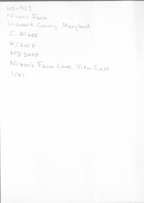
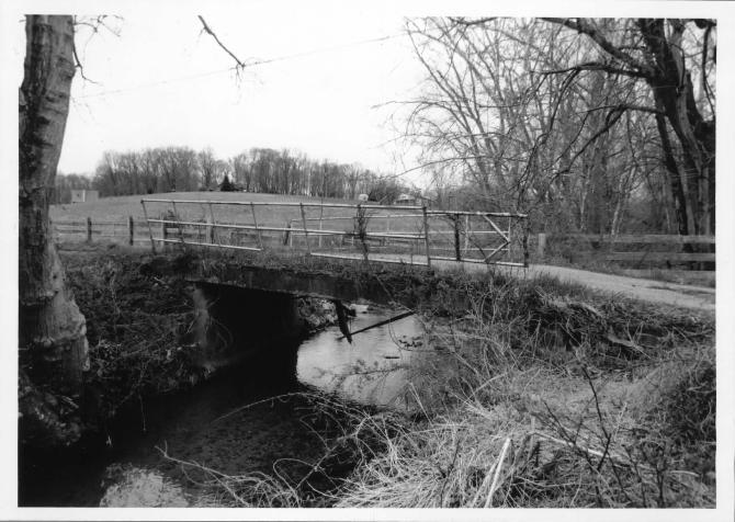
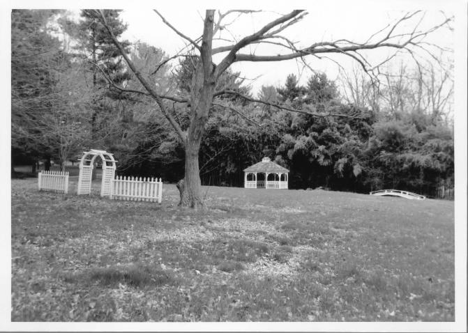
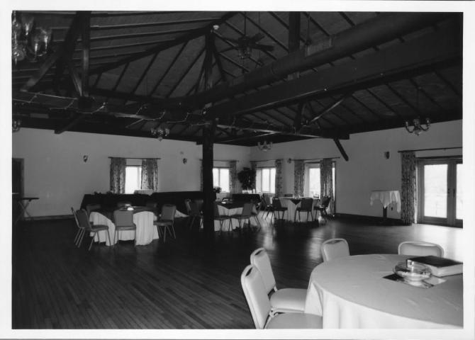
The property is accessed by a paved drive, Nixon's Farm Lane, which extends from Maryland Route 32 along the northern boundary of the property, past the east field, to the building cluster on the knoll. A single-lane concrete bridge with metal rails crosses the Terrapin Branch. Adjacent to Nixon's Farm Lane, on the north side, is an area used for outdoor weddings and consisting of a gazebo, arched pergola, pedestrian bridge, and fencing, all of recent origin. The primary resource on the property, the Event Hall, originally constructed as a bank barn in 1894, is situated at the center of the building cluster (2). The field-stone foundations of the bank barn remain, as do some of the wood structural members, reused on the interior. The Event Hall primarily reflects renovations undertaken in 1999 (3). It has a compound hip roof, and is clad in vertical-grooved plywood, with plate-glass windows and double-leaf glass doors. An open porch wraps around the south and east elevations. The primary interior space is a large open hall that occupies the original main level of the bank barn. The room is largely finished in modern materials, however, some of the original timber roof structure remains extant and exposed. The ground level of the Event Hall contains offices and restrooms. A paved parking lot is located on the west side of the Event Hall. Scattered throughout the trees of the central building cluster are numerous movable picnic tables.
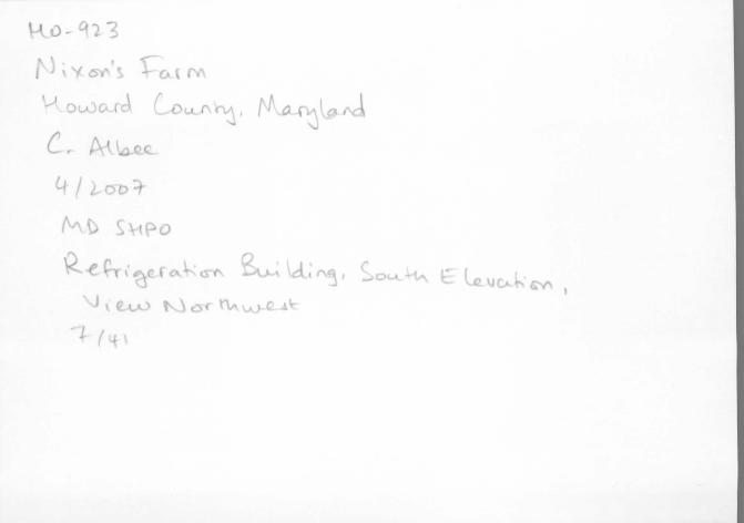
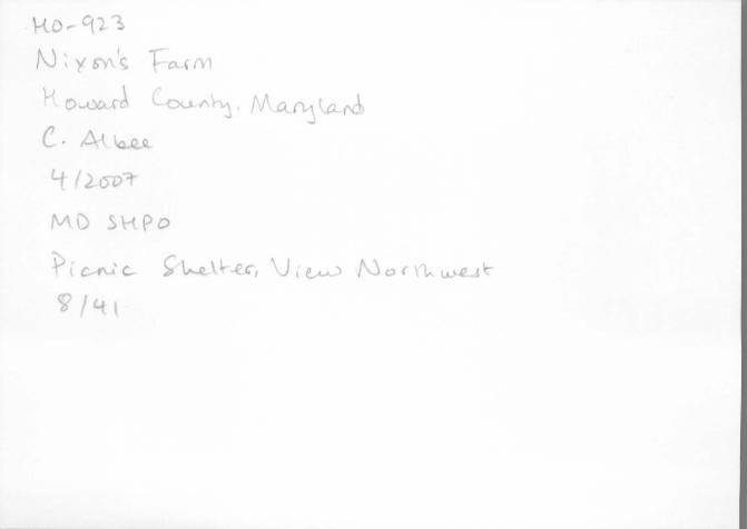
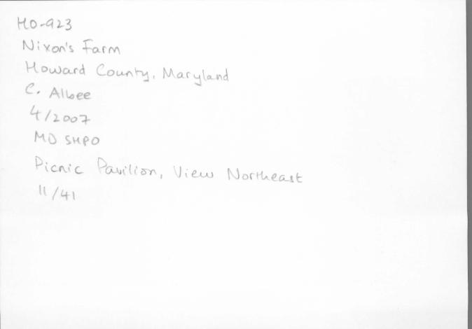
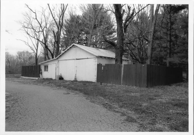
Northwest of the Event Hall is a cluster of buildings and structures. On the north side of the parking lot is a one-story, hip-roof refrigeration building brought to the property circa 1975. Northwest of the refrigerator is a one-story, gable-roof picnic shelter supported on wood posts that dates to the 1980s. The open shelter is located over a poured concrete pad. North of the picnic shelter is a small metal swing set. West of the swing set is a volleyball court with a net suspended between wood posts. West of the volleyball court is the large one-story, gable-roof Picnic Pavilion, built in 2004 to replace an earlier structure damaged in a storm. The open Picnic Pavilion is supported on heavy square timbers and has a poured concrete floor.

Maryland Historical Trust Maryland Inventory of Historic Properties Form
Name Continuation Sheet
Number_]_ Page 1
Inventory No. H0-923
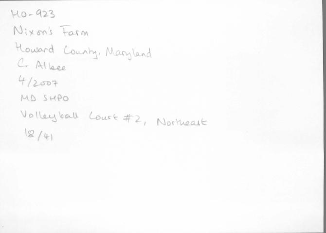
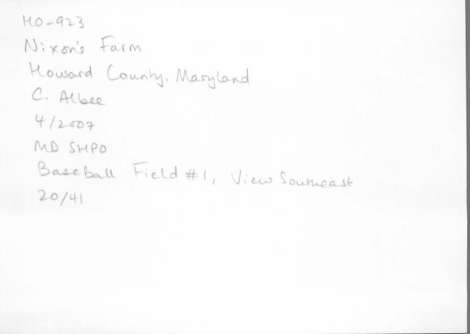
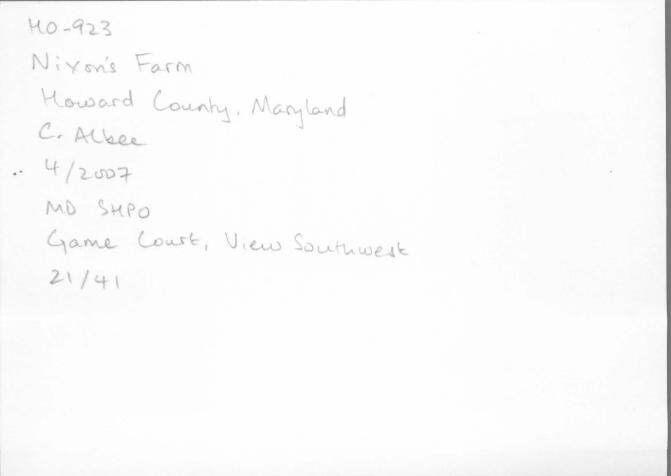
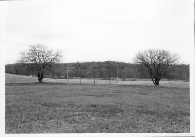
South of the Event Hall parking lot is another cluster of recreational features. Immediately south of the building is a cleared, grassy area that appears to be a game court. Southwest of this feature is a brick outdoor grill sits on a poured concrete pad. East of the grill is a large metal swing set with six swings. South of the swing set is a small wood-frame shed and livestock pen. Northwest of the livestock pen is a one-story, wood-frame, hip-roof building used for cooking and food preparation. The building is screened to keep out insects . North of the food preparation house is a poured concrete pad to accommodate a food serving station. East of the livestock pen is a series of horseshoe stakes. East of the horseshoe court is a volleyball court with wood net posts. East of the volleyball court is a concrete basketball court with nets on metal posts. At a distance from the Event Hall to the northeast is a baseball diamond with a chain-link batting cage.
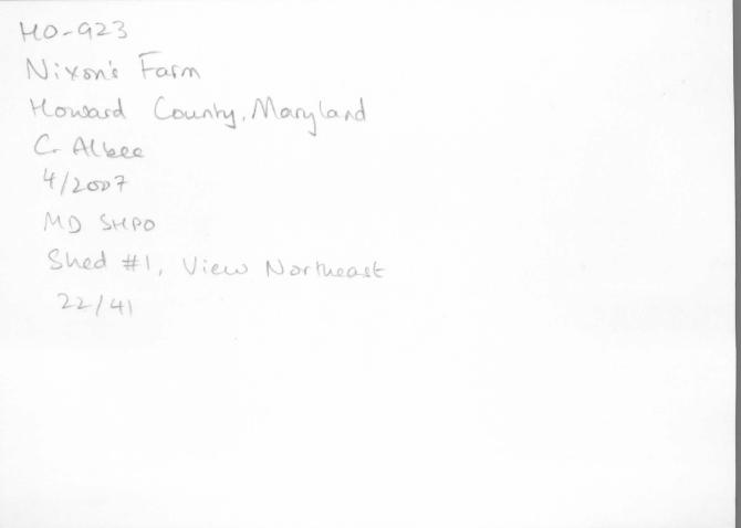
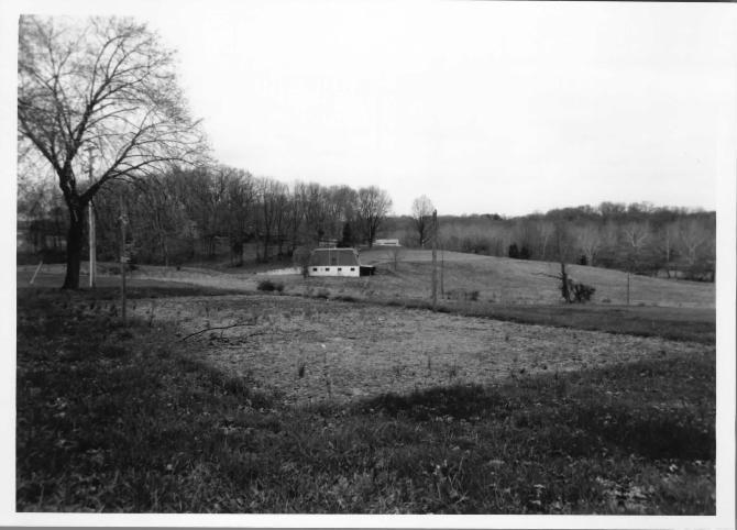
Immediately east of the Event Hall is a small, one-story prefabricated wood shed. Northeast of the shed is what appears to be a concrete stoop flanked by mature boxwoods. During the 1960s a swimming pool was located in this area, and it is likely that this features related to that pool, which is no longer extant. East of the former swimming pool area is a playground with a variety of play structures, including concrete ramps, slides, and jungle gyms. Most of the playground features were installed in the late 1950s. North of the playground is a volleyball court with wood net posts.
A short distance north of the Event Hall, just west of the outdoor wedding area , Nixon's Farm Lane splits into three directions: south to the Event Hall , west to the north field , and north to the Nixon family dwellings. At this fork is a one-story, cinder-block masonry vehicle shed with a gable roof. This vehicle shed was on the site when the Nixons purchased the property in 1957, and appears to date to circa 1940.
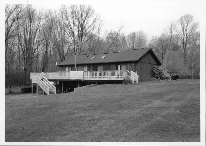
The Nixon family dwellings are located at the northwest corner of the tract, at a high point that overlooks the north field. The Mildred Nixon House, constructed in 1963 and designed by architect Seymour M. Tatar, is a one-story, wood-frame Ranch dwelling with a long, low elevation and a hip roof that projects far beyond the exterior walls. Approached by a circular drive, the house is arranged along an east-west axis. The exterior cladding is plywood with sections of floor-to-ceiling glass. Brick elements accent the rectilinear mass of the house, including cylindrical chimneys, a curved outdoor utility space, and a long freestanding brick wall between the drive and the west yard. The south elevation, overlooking the north field, is primarily glass. Notable on the south elevation is the clerestory on the roof.
The interior of the Mildred Nixon House consists of an open floor plan at the west end of the house and enclosed bedrooms at the east end. The west end of the house contains the living room and dining room, separated by a low partition wall enclosing a small kitchen. This large open end of the house is characterized by floor-to-ceiling glass windows and a ceiling open to the clerestory level. A number of the original furnishings remain, inc luding a formal dining room table and chairs and a dinette set. The east end of the house is accessed by an axial hall that leads to fully separate bedrooms. A notable design feature, however, is the use of glass along the top of the walls between the bedrooms, and translucent corrugated plastic on the hall ceiling to allow the passage light between the rooms and from the clerestory.
Landscaping elements around the house include some foundation shrubbery, mature trees scattered throughout the front and rear lawns. In the terraced south lawn are three raised planters of recent origin and two small ornamental ponds. The south lawn appears to have been terraced, although the terracing shows evidence of erosion. In its current configuration, the landscape reflects substantial alterations from the original design of Wolfgang Oehme. South of the Mi ldred Nixon House is a one-story prefabricated shed.
Northwest of the Mildred Nixon House is the Randall Nixon House, constructed circa 1988 for Roosevelt and Mildred Nixon's son, Randall. The house is one story with a partially exposed basement level. It is clad in vertical-grooved plywood and has a side-gable
Maryland Historical Trust Maryland Inventory of Historic Properties Form
Name Continuation Sheet
Number_]_ Page 2
Inventory No. H0-923
roof. A long wood deck is present on the south elevation of the dwelling. Two prefabricated sheds are located to the west of the Randall Nixon House.
At the south end of the north field are two structures. Close to the west property line is a wood-frame, shed-roof agricultural building in ruins. The original function of this building, which appears to date to the early twentieth century, is unknown. East of the ruins is a baseball diamond with a chain-link batting cage. ·
ENDNOTES
(1) According to the tax records, the three properties that comprise the Nixon ' s Farm tract are 96.9263 , 5.2499, and 7.5068 acres, respectively, adding up to roughly 110 acres. Some of the discrepancy between this acreage and the historic acreage may be accounted for in the widening of Maryland Route 32 or in minor adjustments in surveyors ' measurements. Randall Nixon has indicated, however, that the tax record is incorrect and that the parcels should add up to approximately 129 acres.
(2) Howard County Board of County Commissioners, Assessment Record 1876-1917, microfilm (CM420), Maryland State Archives, Annapolis, Maryland.
(3) Unless otherwise noted, building dates come from oral interviews with Mildred Nixon and Randall Nixon. See Mildred Nixon, interview by Carrie E. Albee, 10 April 2007; and Randa ll Nixon, interview by Carrie E. Albee, 18 April 2007.
8. Significance Period
1600-1699 1700-1799 1800-1899 1900-1999 2000-
Areas of Significance
_ agriculture _ archeology
architecture art commerce communications
_ community planning conservation
Inventory No. H0-923
Check and justify below
economics education
_ engineering entertainment/
recreation _ ethnic heritage _ exploration/
settlement
health/medicine _ performing arts _ industry _ philosophy
invention _ politics/government _ landscape architecture _ religion
law science literature _ social history
_ maritime history _ transportation _ military other:
Specific dates Architect/Builder
Construction dates 1894 (construction), 1965 (alteration), 1999 (alteration/addition)
Evaluation for:
---'X_,__ National Register ____ Maryland Register ____ not evaluated
Prepare a one-paragraph summary statement of significance addressing applicable criteria, followed by a narrative discussion of the history of the resource and its context. (For compliance projects, complete evaluation on a DOE Form - see manual.)
Statement of Significance
Careful evaluation of Nixon ' s Fam1 determined that the property is not eligible for listing in the National Register of Historic Places. Subdivided from Samuel N. Ridgely's Hayfield in 1853, the historic 129-acre tract has remained largely intact to the present day. In the first century after this subdivision, the tract supported a middling-sized farmstead employed in crop cultivation and livestock. Although this is highly characteristic of Howard County during the nineteenth and early twentieth centuries, the property in its current configuration does not retain integrity to this period and is therefore not eligible for listing under Criterion A for Agriculture.
Following its purchase by Roosevelt and Mildred Nixon in 1957, the use of Nixon's Farm changed from agricultural to recreational , and the property was significantly altered as a result. From circa 1961 to 1972, the property served as the Glenwood Country Club, whose membership drew principally from the young African-American professional class of Baltimore. Events held at the Glenwood Country Club included political gatherings attended by prominent figures including six Maryland governors. In 1960, Mildred Nixon retained Baltimore architect Seymour Tatar to design her residence at on the property. Completed in 1963, the Mildred Nixon House is an intact and creative example of a Modem-style Ranch dwelling of the period. While notable, the social and architectural significance of Nixon's Fam1 achieved in the last fifty years is not exceptional, and the property is not eligible for listing under Criterion Consideration G either for significance under Criterion A for Ethnic Heritage and Social History, or under Criterion B for its association with Roosevelt and Mildred Nixon.
Concurrent with the preparation of this evaluation and associated MIHP Form, a Phase I archeological investigation and evaluation of a defined portion of the Nixon 's Farm property was undertaken. The summary report, entitled Phase I A rcheological Survey of the Proposed Nixon 's Farm Wetland Mitigation Site (Project No. H0389B21) and Phase II Evaluation of Site 18H0261 (Project No. H0756A22), Howard County, Maryland, found that none of the sites identified in the study were eligible for the National Register of Historic Places under Criterion D.
Summary
Nixon's Farm is part of a 602-acre tract known as Hayfield that was patented by Samuel N . Ridgely in 1820. At Ridgely' s death in 1850, the land was subdivided into several tracts, among them the 129-acre tract ofNixon's Farm. In the first century after this subdivision, Nixon's Farm supported a middling-sized farmstead employed in crop cultivation and livestock and characteristic of Howard County during the nineteenth and early twentieth centuries. Following its purchase by Roosevelt and Mildred Nixon in 1957, the use of Nixon's Farm changed from agricultural to recreational , and the property was significantly altered as a result. From circa 1961 to 1972, the property served as the Glenwood Country Club, whose membership drew principally from the young African-American professional class of Baltimore. Events held at the Glenwood Country Club included political gatherings attended

Maryland Historical Trust Maryland Inventory of Historic Properties Form
Name Continuation Sheet
Number _JL_ Page 1
Inventory No. H0-923
by prominent figures including six Maryland governors. In 1960, Mildred Nixon retained Baltimore architect Seymour Tatar to design her residence at on the property. Completed in 1963, the Mildred Nixon House is an intact example of a Modern-style Ranch dwelling of the period. Since the closure of the country club in 1972, Nixon's Farm has functioned as a recreational events facility specializing in music festivals, company picnics, and weddings.
Early History, 1820-1884
The 129 acres that currently comprise Nixon' s Farm were originally part of a larger tract patented in the Western Shore Land Office by Samuel Norwood Ridgely in 1820 (4). This tract, named Hayfield, consisted of 602 acres ofland formerly part of two earlier holdings: Howard's Resolution, consisting of 1, 184 acres patented by Henry Howard in 1753; and North Hills, consisting of 211 Y2 acres patented by Vachel Denton Howard in 1775 (5). Samuel Norwood Ridgely (ca. 1775-1850) was the son of Charles "Black Head" Ridgely (1746-1810) and Ruth Norwood (6). A captain in the Unites States Army during the War of 1812, Samuel Norwood Ridgely was born at his parents' home at Springfield, north of Clarksville, in what was then Anne Arundel County (7) . In 1807 he married Deborah Dorsey, with whom he had at least eight children, including his namesake, Samuel Norwood Ridgely, Jr. , born in 1811 , and Mary Dorsey Ridgely (8) .
Following his death in 1850, Samuel Norwood Ridgely' s real estate was sold to settle outstanding debts (9). A 129-acre portion of "Hayfield" was acquired by Charles Harrison, Jr. , for $1 ,548 .00. Harrison (b. ca. 1810) was the husband of Samuel Norwood Ridgely' s daughter, Mary Dorsey Ridgely ( 10). The 1860 federal census indicates that Harrison was a clerk of considerable means living in Catonsville, Maryland, and that he and his wife had twelve children ranging in age from one to twenty-six ( 11 ).
Harrison retained the property for little over a year before selling it to William Russel l of Baltimore in December 1854 for $3 ,000.00 (12). Over the next fourteen years the property changed hands numerous times, but the 129-acre parcel remained intact. In 1857 the property was acquired by Henry Winkel (b. ca. 1808), a Gernian immigrant and resident of Baltimore, for $3 ,500.00 (13). Henry Winkel and his wife, Mary, also a Gennan immigrant, borrowed money from two separate individuals to acquire the property and ultimately defaulted on their mortgage (14). As a result, the property was sold to Edward D. Hughes of Howard County in 1861 (15).
Martenet ' s map of Howard County, published in 1860, reveals the deve lopment pattern of the area at this time ( 16). Sykesville Road (Maryland Rout 32) is not shown south of the Frederick Turnpike, suggesting that it is not yet a major thoroughfare. No names are indicated for the 129-acre Hayfield tract, but two mills are shown on the Middle Patuxent River directly adjacent: a grist mill owned by Dr. C. Ridgely, the brother of Samuel Norwood Ridgely; and a saw mill owned by S. Ridgely, possibly the son of Samuel Norwood Ridgely. The community of West Friendship, while not named, is shown at the intersection of Sykesville Road and the Frederick Turnpike. Among the buildings clustered in this crossroads community are a store, a blacksmith shop, and a wheelwright shop.
In 1863 Edward D. Hughes sold the property to Wi lliam Fincknaur (b. ca. 1822) of Baltimore for $4,000.00 (17). Fincknaur appears to have taken up residence on the property by 1865, as he is identified as a resident of Howard County in a release of that date (18). In 1866, however, Fincknaur sold the property to George W. Peer and John F. Lewis of Howard County for $4, 125.00 (19). Several years later, in 1870, Fincknaur has returned to Baltimore and is listed as a retired grocer (20).
In 1868, the 129-acre parcel, described as "part of Hayfield," was so ld to Mary Saumenig of Howard County for $1 ,625 .00 (21). Mary Saumenig (ca. 1813-1874) and her husband, Jacob, reside on the property with their seven sons (22). Their residency on site is confirmed in Mary Saumenig' s will, prepared in 1869, which bequeaths to Jacob "my plantation whereon I now dwell known by the name of 'Part of Hayfield'" (23). In 1870, the federa l census shows the Saumenig household as including Mary, keeping house, and

Maryland Historical Trust Maryland Inventory of Historic Properties Form
Name Continuation Sheet
Number__§___ Page 2
Inventory No. H0-923
Jacob and the seven sons, aged fifteen to twenty-seven, all (farm) laborers (24). Jacob Saumenig (b . ca. 1810) retains ownership of the property for four years following Mary's death in 1874. The 1878 map of Howard County produced by G. M. Hopkins shows Jacob Saumenig ' s 129 acres between the land of Milton Shipley and Thomas Streaker (25) . As revealed in the map, the community of West Friendship is now identified as such and serviced by a post office. Sykesville Road continues south from the Frederick Turnpike to Isaacsville, running past Saumenig's land and the grist mill and saw mill of Milton Shipley. Jacob Saumenig sold his 129-acre tract to John A. H. Becker in December 1878 (26). However, the 1880 census suggests that Saumenig continued to reside on the property and worked the land for a period of time after the sale. Jacob Saumenig and his three sons are listed as farn1ing among families that are shown in the vicinity of the Saumenig tract on the 1878 Hopkins map, including Grimes, Streaker, and Hennessy. Furthermore, a land transaction in 1890 refers to the property as the "farm known as the Saumenig Place" (27).
Grimes/ Arrington Occupation, 1884-1957
In 1884, the 129-acre Hayfield property was purchased by the owner of the adjacent farm to the south, Basil T. Grimes, also known as Thomas, for $3 ,600.00 (28) . The property would subsequently be held by direct descendents of Thomas Grimes until acquired by the Nixons in 1957. Thomas Grimes (b . ca. 1830) is shown on the 1878 Hopkins map on a 115-acre tract just south of the Middle Patuxent River from Jacob Saumenig. The 1880 census indicates that Thomas, a farmer, and wife Charity were living with seven children between the ages of one and twenty, including Priscilla E. Grimes (29) .
In 1883, Priscilla Grimes married William T. Arrington, who in 1890 purchased the 129-acre Saumenig Place from the Grimes famil y for $4,000.00 (30). The transaction followed a Circuit Court decree that appears to have been related to the settling of Thomas Grimes' estate following his death. Additional information regarding Arrington ' s acquisition of the 129-acre Saumenig Place is recorded in the Howard County tax assessment records. In 1887, William T. Arrington is shown as having no real property and the following personal property: five horses valued at $400; one cow, valued at $20; seven hogs valued at $35 ; furniture valued at $75 ; and farming utensils valued at $235 (31 ). In 1890, the tax assessment records show Arrington with 129 acres in real property, acquired from B. Thomas Grimes, valued at $20 an acre, with improvements thereon valued at $800 (32). To the list of Arrington ' s personal property has been added two horses and two cows. In that same year, Charity E. Grimes is shown as having 115 acres, also from B. Thomas Grimes, suggesting that Thomas Grimes is deceased.
Born in Maryland in 1856, William T. Arrington was the son of Carroll County farmer Thomas D. Arrington (33 ). William T. Arrington and his wife, Priscilla, retained ownership of the 129-acre tract on Sykesville Road for over thirty years, before selling it to their son-in-law, Homer D. McLean in 1921 (34). In the decade following his purchase of the 129-acre farm in 1890, William T. Arrington made several documented improvements, inc luding the construction of a new barn in 1894, valued at $600 (35) . This is likely the bank barn that was incorporated into the existing Event Hall by the Nixons. A documentary photograph of the bank barn prior to the Nixon alterations is currently on display in the basement of Event Hall . The form and materials of the bank barn shown in the photograph are consistent with an 1894 date of construction: namely, a bank barn with a rectangular footprint, a stone foundation , an earthen ramp to a central vehicular doorway, vertical board cladding, and a side-gable roof sheathed in metal with a metal cupola (36).
A few years later, the tax assessment records indicate that William T. Arrington constructed an addition to the "back building," valued at $120 (37) . As the term back building was generally used during the period to refer to a rear ell, this note may indicate the construction of an attached kitchen or other specialized service room to the primary dwelling on the property. In 1901 , tax assessment records show an "addition to house," at a value of $1 ,000.00, a figure that suggests major construction (38). A circa 1957 documentary photograph of the farmhouse that served as the primary dwelling on the property when it was purchased by the Nixons shows the fa9ade of a building consistent with a 1901 date of construction (39). The dwelling depicted is a two-story, five-

Maryland Historical Trust Maryland Inventory of Historic Properties Form
Name Continuation Sheet
Number _JL Page 3
Inventory No. H0-923
bay, symmetrical building with a cross-gable roof sheathed in seamed metal. It has a central gable exhibiting sawn bargeboards and a one-story, wrap-around porch on turned posts. The house is clad in asphalt sheet cladding and a brick interior end chimney is visible. This portion of the dwelling may have been built onto a pre-existing older dwelling on the property as was common practice in the nineteenth century, hence the description in the tax assessment records as an addition.
The 1900 federal census shows William and Priscilla Arrington with five children in their household between the ages of six and fifteen: four girls, including Goldie E.; and one son, William 0. Arrington. William T. Arrington is listed as a farmer, assisted by one farm laborer, an African-American man named Morris Perry who is boarding with the family. The 1910 federal census confirms that William T. Arrington owned the "general farm" on which he resided. In 1920, William and Priscilla Arrington, living alone, are denoted as owning a truck farm (40). However, it appears that they were no longer living on their 129-acre farm, and are shown instead as living "north of Frederick Turnpike." The farm appears to have been occupied at that time by the Arrington's daughter, Goldie E. , and her husband Homer D. McLean (1882-1966), who are shown as renting the general farm on which they resided in 1920 ( 41 ). The following year, in 1921 , William T. Arrington sold the farm to the McLeans along with two smaller parcels in Howard County (42).
ln 1939, Homer and Goldie McLean sold the 129-acre fam1 to Priscilla E. Selby for $6,300.00 (43). William T. Arrington was by that time deceased and his widow, Priscilla, was remarried to Joseph Selby. Shortly after acquiring the property, Priscilla Selby sold the 129-acre tract to her son, William 0 . Arrington (b. ca. 1893), and his wife Catherine (44) . When the Nixons purchased the farm from William 0. and Catherine Arrington in 1957, the Arringtons were residing on the property (45) . The Arringtons raised cattle on the fann and cultivated associated crops including com, wheat, barley and alfalfa (46). Buildings present on the 129-acre tract included the bank barn (now the Event Hall) and the vehicle shed, as well as a number of buildings that are no longer extant, including the farmhouse , a com crib, tack house, chicken coop, and hen house (47).
Recreational Period, 1957-Present
Mildred Nixon was born Mildred Joyce Barnes in Charlotte, North Carolina, on January 23 , 1928 (48). She was one of seven children born to Chalmers Aaron Barnes and Ophelia Willoughby in the Greenville neighborhood of the city. When Mildred was about six years old, her parents divorced, and she and her siblings were separated. After her mother was no longer able to financially support her, Mildred lived for a time with her father and his new wife in the historically black Biddleville neighborhood. Mildred attended the Second Ward High School in Charlotte, graduating in 1946 at the age of eighteen. While in high school, a vocational specialist placed Mildred in a job at a barber shop owned by an African-American woman only a few years her senior. Mildred learned the trade, and upon moving to Baltimore in 1947, found a job in a barber shop where she met Roosevelt Nixon.
Roosevelt Nixon was born on January 23 , 1926, in Rocky Point, North Carolina. The son of farmers , Roosevelt moved to Baltimore and was working as an automobile mechanic when he met Mi ldred. The couple married in 1949, and within months purchased their first house for $6,500.00 at 1919 W. Lexington Street in a historically Jewish neighborhood in downtown Baltimore. In the next few years, Roosevelt and Mildred has two sons: Reginald Todd, born in 1952; and Randall Keith, born in 1956. Roosevelt supported the family through a variety of business ventures including a grocery store, liquor store, a pharmacy, a Bible book store, and a gypsy cab company.
Mildred Nixon initially worked in the grocery store on Fremont Avenue, but following an illness turned her attention towards real estate, an interest initially inspired by her mother that has remained consistent throughout her life. While living in Baltimore, Mildred and Roosevelt bought and sold a number of investment properties. One of the largest investments was in a fourteen-unit apartment building at 2940 Reisterstown Road in northwest Baltimore. The Nixons lived in two units while renovating the building, which they eventually sold in 1978.

Maryland Historical Trust Maryland Inventory of Historic Properties Form
Name Continuation Sheet
Number__§_ Page 4
Inventory No. H0-923
During the summer of 1956, Mildred and Roosevelt made frequent excursions to Howard County to escape the city. Mildred had always wanted to own a farm, and in 1957, she and Roosevelt purchased the 129-acre tract from William 0 . Arrington (49). At the time, Mildred remembers that there were few African Americans living in the West Friendship community. Although they maintained their primary residence in Baltimore, the Nixons spent as much time as possible at the Howard County farm. They invited children and friends from their neighborhood and church in Baltimore to the farm, which soon became known as Nixon's Farm, for camping trips and picnics.
The Nixons initially stayed in the farmhouse while on the property despite the deteriorated condition of the building. After the farmhouse was razed in 1958, the Nixons stayed in the ground level of the bank barn. In 1959, Mildred hired a friend from Baltimore to convert the ground level of the bank barn into an apartment for the family, and to install playground equipment to the east of the barn for the enjoyment of the chi ldren that came to the farm .
In 1960, Mildred Roosevelt began taking business and accounting classes at McCoy College in Baltimore. At this time, Mildred began reading about local real estate trends, particularly the increasing urban development around the cities of Baltimore and Washington, and the decrease in profitability of farming in the area. In response, Mildred and Roosevelt formally incorporated the Glenwood Country Club at Nixon's Farm circa 1961 and began taking memberships. During the period that the Glenwood Country Club operated at Nixon ' s Farm from the early 1960s until 1972 , the Nixons developed recreational facilities on the ground to accommodate the members. At the center of the property was the bank barn, used for events and camping, and the swimming pool around which picnics and beauty pageants were held. Volleyball, baseball, basketball and tennis courts were installed on the grounds, and a driving range set up in the east field , adjacent to Maryland Route 32. Swing sets and playground equipment were installed for the children.
Approximately 2,200 trees were planted throughout the property, primarily around the central building cluster. In the early 1960s, the Maryland Department of Natural Resources contributed to the recreational activity on the property by creating the fish pond at the south end of the site, intended for both public recreation and for fire protection. Glenwood Country Club supported a herd of cattle as well as horses and pigs. A day camp schedule from 1963 reveals that both boys and girls, ages six through thirteen, were kept busy with a variety of mental, physical, and social activities including dancing, swimming, horseback riding, hiking, chess, music , and archery (50) .
An integral component to the appeal of the Glenwood Country Club was the food, still the specialty of Nixon' s Farm. For casual outdoor events and picnics, food was prepared outdoors and served at stations on the grounds. For more formal indoor events, the barn accommodated up to 250 people and choices on the menu included sirloin steak, fried chicken, filet mignon, jumbo shrimp, crab cakes, and a selection of pies baked on site (51 ). In 1965, the upper portion of the bank barn was removed to reduce maintenance costs.
Although the Glenwood Country Club had open membership, members consisted primarily of families from the circle of AfricanAmerican professionals known to Roosevelt and Mildred through their neighborhood, church, and business ventures. The Small Businessman's League of Baltimore, founded by Roosevelt Nixon in response to the exclusion of African Americans and Jews from the Chamber of Commerce, held their meetings at the club, as did a variety of African-American social clubs and organizations including the Masons and Jack and Jill of Anlerica. Roosevelt Nixon's involvement with the Howard County NAACP and the Prince Hall Masons further expanded the potential client base of the club (52). Politicians courting the African-American vote attended events at the Glenwood Country Club, including six Maryland governors: Theodore McKeldin, Spiro Agnew, Marvin Mandel, Blair Lee, Harry Hughes and William Schaefer. Prominent African-American figures Aris T. Allen, member of the Maryland State Legislature, and tennis professional Althea Gibson were guests on the property. The club also served as the location for team events of the Baltimore Colts attended by Johnny Unitas and Don Shula.
Maryland Historical Trust Maryland Inventory of Historic Properties Form
Name Continuation Sheet
Number__§___ Page 5
Inventory No. H0-923
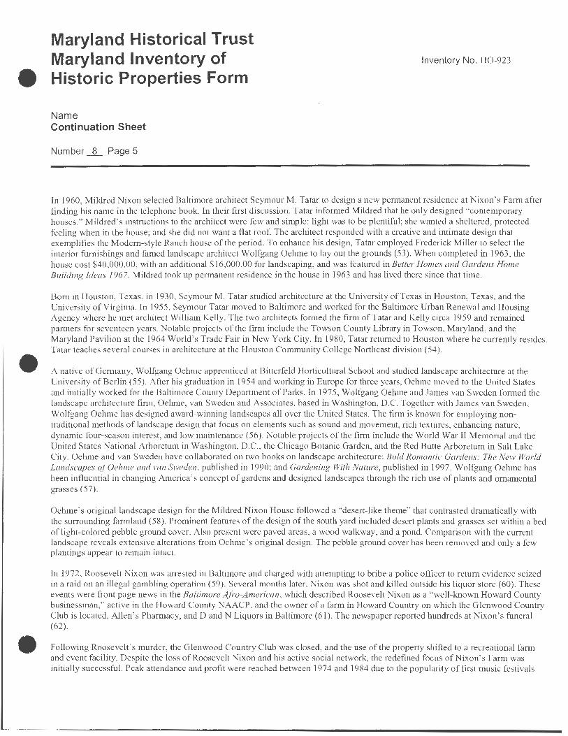
In 1960, Mildred Nixon selected Baltimore architect Seymour M. Tatar to design a new permanent residence at Nixon's Farm after finding his name in the telephone book. In their first discussion, Tatar informed Mildred that he only designed "contemporary houses ." Mildred's instructions to the architect were few and simple: light was to be plentiful; she wanted a sheltered, protected feeling when in the house; and she did not want a flat roof. The architect responded with a creative and intimate design that exemplifies the Modem-style Ranch house of the period. To enhance his design, Tatar employed Frederick Miller to select the interior furnishings and famed landscape architect Wolfgang Oehme to lay out the grounds (53). When completed in 1963, the house cost $40,000.00, with an additional $16,000.00 for landscaping, and was featured in Better Homes and Gardens Home Building Ideas 1967. Mildred took up permanent residence in the house in 1963 and has lived there since that time.
Born in Houston, Texas, in 1930, Seymour M. Tatar studied architecture at the University of Texas in Houston, Texas, and the University of Virginia. In 1955, Seymour Tatar moved to Baltimore and worked for the Baltimore Urban Renewal and Housing Agency where he met architect William Kelly. The two architects formed the firm of Tatar and Kelly circa 1959 and remained partners for seventeen years. Notable projects of the firm include the Towson County Library in Towson, Maryland, and the Maryland Pavilion at the 1964 World's Trade Fair in New York City. In 1980, Tatar returned to Houston where he currently resides. Tatar teaches several courses in architecture at the Houston Community College Northeast division (54).
A native of Germany, Wolfgang Oehme apprenticed at Bitterfeld Horticultural School and studied landscape architecture at the University of Berlin (55). After his graduation in 1954 and working in Europe for three years, Oehme moved to the United States and initially worked for the Baltimore County Department of Parks. In 1975, Wolfgang Oehme and James van Sweden formed the landscape architecture firm, Oehme, van Sweden and Associates, based in Washington, D.C. Together with James van Sweden, Wolfgang Oehme has designed award-winning landscapes all over the United States. The firm is known for employing nontraditional methods of landscape design that focus on elements such as sound and movement, rich textures, enhancing nature, dynamic four-season interest, and low maintenance (56). Notable projects of the firm include the World War II Memorial and the United States National Arboretum in Washington, D.C., the Chicago Botanic Garden, and the Red Butte Arboretum in Salt Lake City. Oehme and van Sweden have collaborated on two books on landscape architecture: Bold Romantic Gardens: The New World Landscapes of Oehme and van Sweden , published in 1990; and Gardening With Nature, published in 1997. Wolfgang Oehme has been influential in changing America ' s concept of gardens and designed landscapes through the rich use of plants and ornamental grasses (57).
Oehme' s original landscape design for the Mildred Nixon House fo llowed a "desert-like theme" that contrasted dramatically with the surrounding farmland (58). Prominent features of the design of the south yard included desert plants and grasses set within a bed of light-colored pebble ground cover. Also present were paved areas, a wood walkway, and a pond. Comparison with the current landscape reveals extensive alterations from Oehme ' s original design. The pebble ground cover has been removed and only a few plantings appear to remain intact.
In 1972, Roosevelt Nixon was arrested in Baltimore and charged with attempting to bribe a police officer to return evidence seized in a raid on an illegal gambling operation (59). Several months later, Nixon was shot and killed outside his liquor store (60). These events were front page news in the Baltimore Afro-American, which described Roosevelt Nixon as a "well-known Howard County businessman," active in the Howard County NAACP, and the owner of a farm in Howard Country on which the Glenwood Country Club is located, Allen ' s Pharmacy, and D and N Liquors in Baltimore (61 ). The newspaper reported hundreds at Nixon's funeral (62).
Following Roosevelt's murder, the Glenwood Country Club was closed, and the use of the property shifted to a recreational farm and event facility. Despite the loss of Roosevelt Nixon and his active social network, the redefined focus of Nixon' s Fam1 was initially successful. Peak attendance and profit were reached between 1974 and 1984 due to the popularity of first music festivals

Maryland Historical Trust Maryland Inventory of Historic Properties Form
Name Continuation Sheet
Number_§___ Page 6
Inventory No. H0-923
and then company picnics. During this period, the freestanding refrigerator building was purchased and placed on the site circa 1975, and the swimming pool was removed in 1981 following the drowning ofa child.
Since the 1990s, business has steadily decreased at Nixon' s Farm, leading the Nixons to experiment with alternate enterprises, including a brunch restaurant, open only for a year in 1991, and an assisted living facility that operated out of Mildred Nixon ' s residence from 1993 to 2004. Since the closure of the Glenwood Country Club, the clientele has also shifted and African Americans now make up a minority of the patrons to Nixon's Farm. In 1999, the Event Hall underwent a major renovation and a kitchen was added to better accommodate the growing market for wedding venues. Due to tightened health code restrictions, cooking is no longer done outside. In 2004, the Picnic Pavilion was rebuilt following the destruction of the original building in a storm.
ENDNOTES
(4) Anne Arundel County Court, "Samuel N. Ridgely, his patent, 602 acres, Hay Field," Liber IB F, Folio 393 , Plats, microfilm (SR7785) , Maryland State Archives, Annapolis, Maryland.
(5) Anne Arundel County Court, "Samuel N. Ridgely, his patent, 602 acres, Hay Field," Liber GGB H, Folio 272 , Plats, microfilm (SR7787) , Maryland State Archives, Annapolis, Maryland.
(6) "White Wine and Claret," Ridgely Surname File, Howard County Historical Society, Ellicott City, Maryland. (7) "White Wine and Claret" ; Genealogical notes, Ridgely Surname File, Howard County Historical Society, Ellicott City,
Maryland; and familysearch.org. (8) Genealogical notes. (9) Liber 15, Folio 371 , Land Records ofHoward County, Maryland. Note that the land records of Howard County from the 1850s
to the present are available online at the Howard County Land Records and Licensing Department in Columbia, Maryland. (I 0) Genealogical notes. ( 11) United States Census Bureau, 1860 Decennial Census. (12) Liber 15, Folio 375 . (13) United States Census Bureau, 1860 Decennial Census; Liber 18, Folio 397. (14) Liber 21 , Folio 625. (15) Liber 21 , Folio 625. (16) Simon J. Martenet, Marte net and Bond 's Map of Howard County, Maryland (Baltimore: S. J. Martenet, 1860). (17) Liber 22, Folio 371. (18) Liber 24, Folio 56 . (19) Liber 25 , Folio 321. (20) United States Census Bureau, 1870 Decennial Census. (21) Liber 30, Folio 65. (22) United States Census Bureau, 1870 Decennial Census. (23) Howard County Register of Wills, Liber TBH 2, Folio 237, 1874, Wills 1851-1976, microfilm (CM634), Maryland State
Archives, Annapolis, Maryland. (24) United States Census Bureau, l 870 Decennial Census. (25) G. M. Hopkins, Atlas of Fifteen Miles Around Baltimore Including Howard County, Maryland (Philadelphia: G. M. Hopkins,
1878; reprint Ellicott City, MD: Howard County Historical Society, 1988). (26) Liber 40, Folio 329. (27) Liber 55 , Folio 444. (28) Liber 48 , Folio 472. (29) United States Census Bureau, 1880 Decennial Census.

Maryland Historical Trust Maryland Inventory of Historic Properties Form
Name Continuation Sheet
Number _JL_ Page 7
(30) United States Census Bureau, 1900 Decennial Census; and Liber 55 , Folio 444. (31) Assessment Record 1876-1917. (32) Assessment Record 1876-1917. (33) United States Census Bureau, 1880 Decennial Census. (34) Liber 112, Folio 326. (35) Assessment Record 1876-1917.
Inventory No. H0-923
(36) Original photograph of bank barn in the collection of the Nixon family. At the time of the property survey, the photograph was on display in the Event Hall basement.
(3 7) Assessment Record 1876-1917. (38) Assessment Record 1876-1917. (39) Original photograph of farmhouse in the collection of the Nixon fami ly. At the time of the property survey, the photograph was
on display in the Event Hall basement. (40) United States Census Bureau, 1920 Decennial Census. (41) United States Census Bureau, 1920 Decennial Census; and familysearch.org . ( 42) Liber 112, Folio 326. (43) Liber 163, Folio 466. (44) Liber 163, Folio 466. (45) Mildred Nixon. (46) Mildred Nixon. (47) Mildred Nixon; and Randall Nixon. ( 48) Unless otherwise noted, history of the Nixon occupation is derived from oral interviews with Mildred Nixon and Randall
Nixon. See Mildred Nixon; and Randall Nixon. (49) Liber 294, Folio 256. (50) Original summer camp schedule for June 24 through August 31, 1963 in the collection of the Nixon family. At the time of the
property survey, the document was on disp lay in the Event Hall basement. (51) Original menus from the Glenwood Country Club in the collection of the Nixon family. At the time of the property survey, the
documents were on display in the Event Hall basement. (52) "Roosevelt Nixon charged, freed on $25,000 bail," Baltimore Afro-American, 11 July 1972; "Hundred at Roosevelt Nixon
rites," Baltimore Afro-American, 28 November 1972; and "Charge 2 teens in Roosevelt Nixon murder," Baltimore AfroAmerican, 5 December 1972.
(53) "Pace-Setting Design," Better Hom es and Gardens: Home Building Ideas, 1967: 62. (54) Seymour M. Tatar, interview by Sarah Cleary, 19 July 2007. (55) Unless otherwise noted, information on Wolfgang Oehme and James van Sweden was derived from the firm 's website. See
Oehme, van Sweden & Associates, http: //www.ovsla.com/ (last viewed 19 July 2007). (56) Andrea Oppenheimer Dean, "Men for all seasons," Landscape Architecture, July 1997, v. 87, n. 7. (57) James van Sweden, Gardening with Nature (New York: Random House, Inc. , 1997). (58) "Pace-Setting Design." (59) "Roosevelt Nixon charged, freed on $25,000 bail." (60) "Hundred at Roosevelt Nixon rites." (61) "Roosevelt Nixon charged, freed on $25,000 bail." (62) "Hundred at Roosevelt Nixon rites."

Maryland Historical Trust Maryland Inventory of Historic Properties Form
Name Continuation Sheet
Number _JL_ Page 8
CHAIN OF TITLE
1957, Feb 28 Roosevelt and Mildred Nixon Liber 294, Folio 256
1939, May 30 William 0. and Catherine M. Arrington Lib er 163, Folio 466
1939, Apr 15 Priscilla E. Selby Liber 163, Folio 466
1921 , Apr 26 Homer D. and Goldie E. McLean Liber 112, Folio 326
1890, Mar 8 William T. and Priscilla E. Arrington Liber 55, Folio 444
1884, Nov 5 Basil T. and Charity E. Grimes Liber 48, Folio 472
1878, Dec 21 John A. H. Becker Liber 40, Folio 329
1868, Jun 4 Jacob and Mary Saumenig Liber 30, Folio 65
1866, Jun 15 George W. Peer and John F. Lewis Liber 25, Folio 321
1863, Apr 11 William Fincknaur Liber 22, Folio 371
1861,Sep7 Edward D. Hughes Liber 21, Folio 625
1857, Sep 25 Henry 0. and Mary Ann Winkel Liber 18, Folio 397
1854, Dec 20 William Russell Liber 15, Folio 375
1853, Sep 12 Charles, Jr. , and Mary D. Harrison Liber 15, Folio 371
Inventory No. H0-923

9. Major Bibliographical References Inventory No. H0-923
Assessment Records of Howard County, Maryland. Hopkins' Atlas of Fifteen Miles Around Baltimore Including Howard County, Maryland ( 1878). Land Records of Howard County, Maryland. Martenet and Bond 's Map of Howard County, Maryland (1860). Mildred Nixon, interview by Carrie E. Albee, 10 April 2007. Randall Nixon, interview by Carrie E. Albee, 18 April 2007. United States Census, 1860-1920. See Endnotes for full citations.
10. Geographical Data
Acreage of surveyed property Acreage of historical setting Quadrangle name
Approx. 129 acres Approx. 129 acres Sykesville
Verbal boundary description and justification
Quadrangle scale: _1_: 2_4~0~0~0 ____ _
The surveyed property consists of three contiguous parcels: Parcel 90, May 15, owned by Mildred Nixon; Lot 1, Parcel 267 , Map 15, owned by Mildred Nixon; and Lot 2, Parcel 267, Map 15, owned by Randall and Jennifer Nixon. These three parcels together form the approximately 129-acre tract acquired by Roosevelt and Mildred Nixon in 19 57. The survey includes all three parcels because, although identified as distinct parcels for tax purposes, they remain in the Nixon family and are directly related visually, functionally, and historically. The boundaries of the surveyed property and the historical setting are approximately the same. The three surveyed parcels together comprise the approximately 129-acre tract that was acquired by Charles Harrison, Jr. , in 1853 following the subdivision of the larger tract known as Hayfield in the settling of the estate of Samuel N. Ridgely.
11. Form Prepared by
name/title
organization
street & number
city or town
Carrie Albee, Architectural Historian
URS Corporation date July 23 , 2007
200 Orchard Ridge Drive, Suite 101 te lephone (301) 258-9780
Gaithersburg state MD
The Maryland Inventory of Historic Properties was officially created by an Act of the Maryland Legislature to be found in the Annotated Code of Maryland, Article 41 , Section 181 KA, 1974 supplement.
The survey and inventory are being prepared for information and record purposes only and do not constitute any infringement of individual property rights.
return to: Maryland Historical Trust Maryland Department of Planning 100 Community Place Crownsvil le, MD 21032-2023 410-514-7600

Maryland Historical Trust Maryland Inventory of Historic Properties Form
Nixon's Farm Continuation Sheet
Number i Page 1
3. Owner of Property (Continued)
Mildred Nixon 2800 Route 32 West Friendship, MD 21794 (410) 442-2269
Randall and Jennifer Nixon 2800 Route 32 West Friendship, MD 21794 (410) 442-2151
Inventory No. H0-923
Maryland Historical Trust Maryland Inventory of Historic Properties Form
Nixon's Farm Continuation Sheet
Number___.±_ Page 1
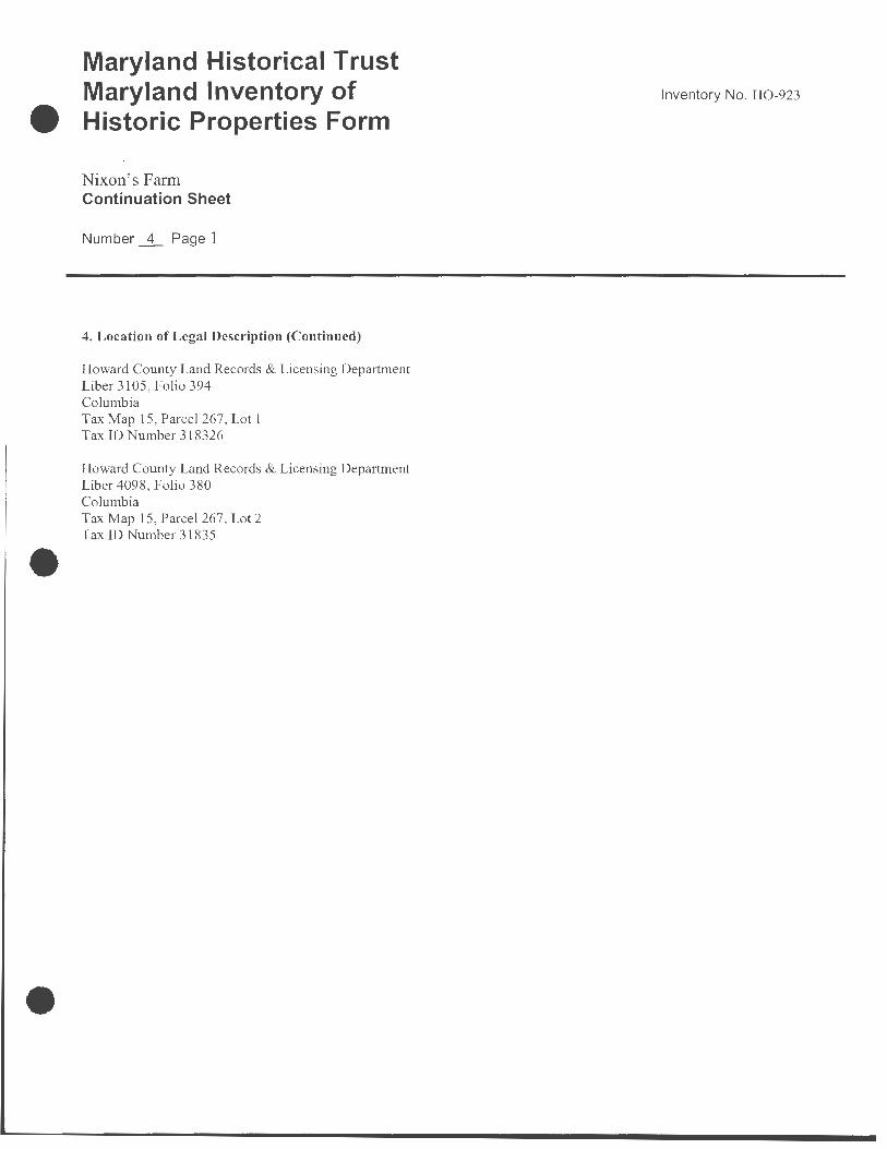
4. Location of Legal Description (Continued)
Howard County Land Records & Licensing Department Liber 3105, Folio 394 Columbia Tax Map 15, Parcel 267, Lot 1 Tax ID Number 318326
Howard County Land Records & Licensing Department Liber 4098, Folio 380 Columbia Tax Map 15, Parcel 267, Lot 2 Tax ID Number 31835
Inventory No. H0-923

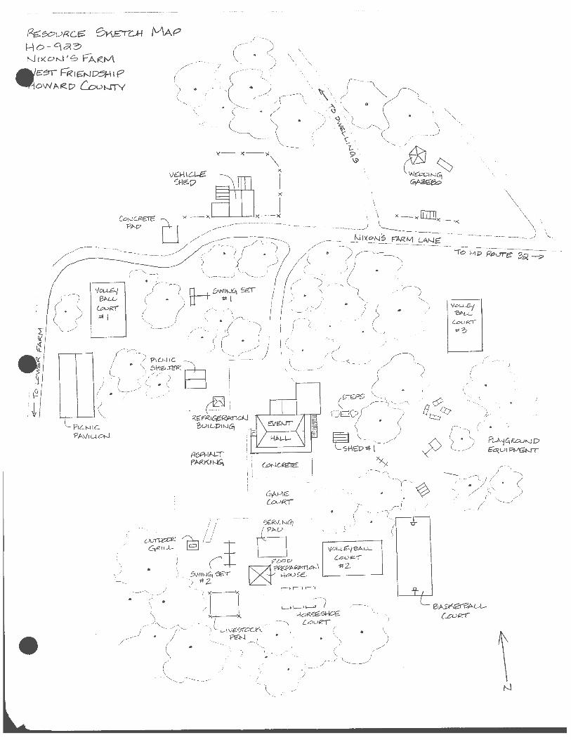
H0-923 Nixon's Farm West Friendship, Howard County Sykesville Quad Scale: 1 :24,000

•
Maryland Department of Assessments and Taxation HOWARD COUNTY
,,, . .. Real Property Data Search
District - 03 Account Number - 292444
'1
\ ,l
" \ \
\
rage 1 or i
Go Back View Map New Search
Property maps provided courtesy of the Maryland Department of Planning ©2006. For more information on electronic mapping applications, visit the Maryland Department of Planning
web site at www.mdp.state.rnd.us/webcom/index.html
http://sdatcert3.resiusa.org/rp _rewrite/maps/showmap.asp?countyid= 14&accountid=03+29 ... 7 /18/2007
"'·,, \
··\_ .... ,
\
,·
'
It
\ N

Re:ecui<ce. ~-rc..H /V\AP Ho-~~3 ) l'Jl>(ot--J'S f"°A.Rt..A. LM1L-DRE:O W1XON \-b.;se:
$1 t="!<l~.DS>HI p DWA~D Cou~y