marine information objects: what, why and how
TRANSCRIPT

Dr. Lee Alexander, Univ. of New Hampshire
Michel Huet, IHB
Marine Information Objects: What, Why and How

Marine Information Objects (MIOs)
- Chart and navigation-related information that supplement the minimum information required by IMO ECDIS
• Additional, non-mandatory• Not covered by existing standards (e.g., IHO
S-57, IHO S-52, or IEC 61174)• The “everything else”• Points, lines, areas, features, objects
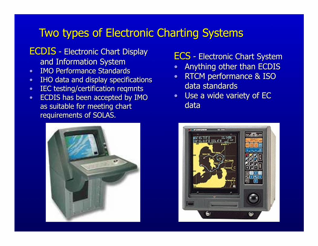
Two types of Electronic Charting Systems
ECS - Electronic Chart System• Anything other than ECDIS• RTCM performance & ISO
data standards• Use a wide variety of EC
data
ECDIS - Electronic Chart Display and Information System
• IMO Performance Standards• IHO data and display specifications• IEC testing/certification reqmnts• ECDIS has been accepted by IMO
as suitable for meeting chart requirements of SOLAS.

MIOs

IMO-compliant ECDIS
ENC Definition:“all the chart information necessary for
safe navigation and may contain supplementary information in addition to that contained in the paper chart which may be considered necessary for safe navigation.”
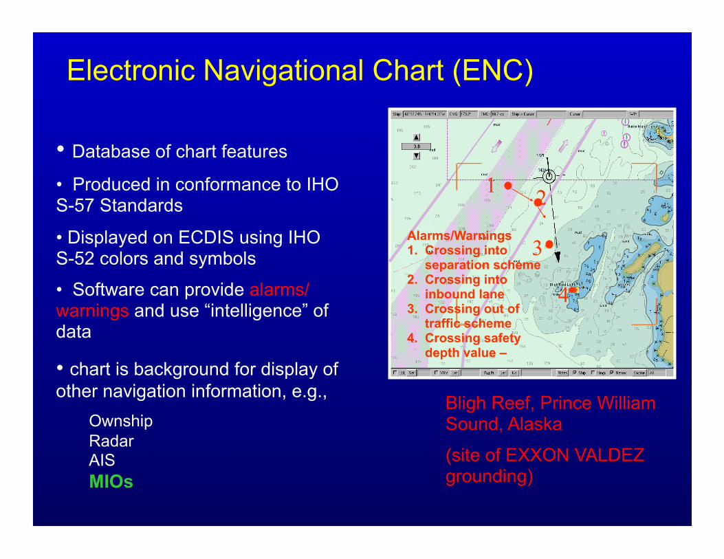
Electronic Navigational Chart (ENC)
• Database of chart features
• Produced in conformance to IHO S-57 Standards
• Displayed on ECDIS using IHO S-52 colors and symbols
• Software can provide alarms/ warnings and use “intelligence” of data
• chart is background for display of other navigation information, e.g.,
OwnshipRadarAISMIOs
Bligh Reef, Prince William Sound, Alaska
(site of EXXON VALDEZ grounding)
1 2
3Alarms/Warnings1. Crossing into separation scheme 2. Crossing into inbound lane3. Crossing out of traffic scheme4. Crossing safety depth value –
4

Types of MIOs
Tides / water levelsIce coverageMeteorologicalOceanographicMarine Habitats (e.g., coral reefs)
Environmental Protection (e.g., Marine Protected Areas)
ArcheologicalSecurityPipelines/cablesAids-to-navigation

Display Standards/Specifications
IMO Performance Standards for ECDIS:
1. Chart-related“IHO recommended colours and symbols (IHO S-52)
should be used to display SENC information”
2. Navigation-related“other navigational information may be added to the
ECDIS display. However it should not degrade …and be clearly distinguishable from SENC information.”
“the colours and symbols used to describe navigational elements and parameters …are published in IEC 61174”
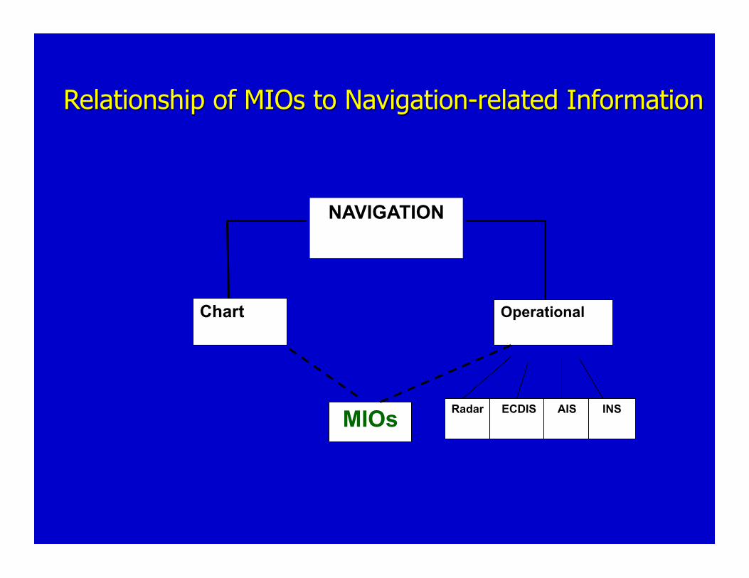
Relationship of MIOs to Navigation-related Information
NAVIGATION
Chart Operational
MIOs Radar ECDIS AIS INS
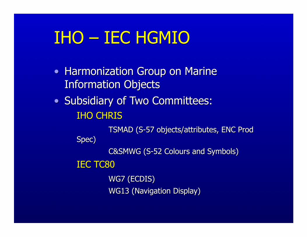
IHO – IEC HGMIO
• Harmonization Group on Marine Information Objects
• Subsidiary of Two Committees: IHO CHRIS TSMAD (S-57 objects/attributes, ENC Prod
Spec) C&SMWG (S-52 Colours and Symbols)
IEC TC80 WG7 (ECDIS) WG13 (Navigation Display)

Foundation Data Layers for Marine GIS
• Shoreline• Bathymetry• Cadastral (boundary)• Environmental Sensitivity
Index• Habitat and species location• Benthic mapping (seagrass,
corals, …)• Ports and vessel traffic • Geo-regulations

Ortho photo Raster chart

High-Density Bathymetry(Multibeam survey)

Integrated Topo-Bathy ModelNOAA Bathymetry
USGS Topography
Integrated Topo-Bathy Database
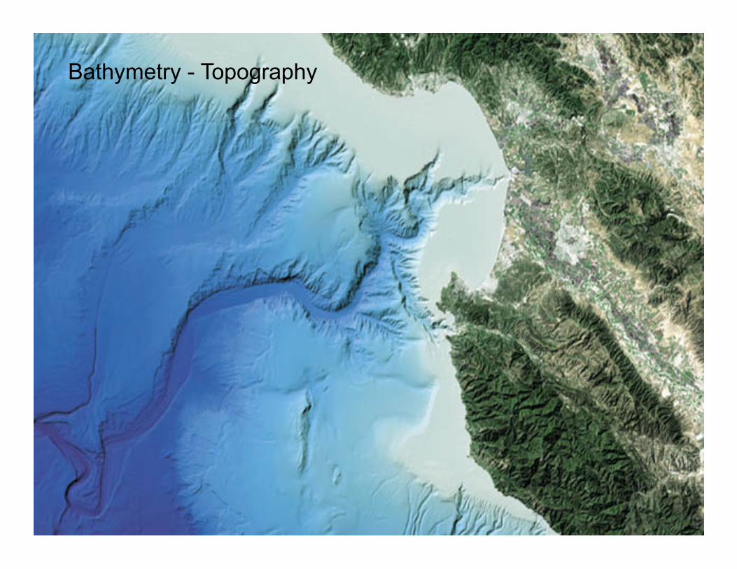
Bathymetry - Topography

Seafloor Classification

www.csc.noaa.gov/crs/bhm/
Benthic Mapping
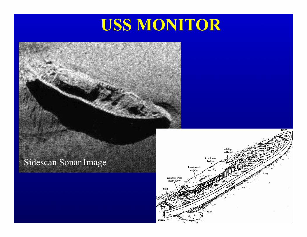
USS MONITOR
Sidescan Sonar Image

Two basic types of MIOs StaticBathymetric (e.g., gridded data)
Geophysical data (seismic, gravity, magnetic)
Seafloor classification/physiographyArcheological (wrecks, heritage sites)
Critical Habitats (e.g., coral reefs, nesting sites)
DynamicTides (predicted, real-time, forecast)
Current flow (speed, direction, time of occurrence)
Meteorological (wind speed/direction)
Oceanographic (wave height/direction, salinity, temp)
Ice Coverage

Goal for MIOs
• Supplemental information for “decision support”
• Right information for task-at-hand• Voyage planning & route monitoring
• How displayed less important than data format and content
• Accurate, timely, and useable