marine archaeology and lundy an historical view...marine archaeology and lundy philip robertson and...
TRANSCRIPT
Marine Archaeology and Lundy
Philip Robertson and John Heath
Introduction Beneath the waves off Lundy remain some fascinating relics of the island's rich maritime past. Out of sight for most of Lundy's visitors, these archaeological sites should not be out of mind. It is with the study of these wrecks, as well as other material evidence of mankind's historical relationship with the sea that marine archaeology is principally concerned. As a subject, marine archaeology developed after the invention of the aqualung in the 1940s and was pioneered in particular by archaeologists in the Mediterranean in the 1960s who learned to apply land techniques under water on excavations of Bronze Age shipwrecks off the coastline of Turkey. Since the 1960s marine archaeology in Europe has brought to light vital information of our maritime past from famous wrecks such as Henry VIII's Mary Rose, the magnificent Wasa in Stockholm (Sweden), the Viking ships at Roskilde (Denmark), the cargo vessels of the Classical Mediterranean, and the ships of the Spanish Armada. While shipwrecks are perhaps the most obvious line of enquiry for the marine archaeologist, landscapes submerged by rising sea levels since the last ice age, fish-traps, and ancient harbours are just a few other examples of what interests this discipline.
An historical view As far as research into the marine archaeology of Lundy is concerned, the overall aim has been to learn about the island's role within the maritime setting of north Devon and the Bristol Channel; to learn about the design and function of some of the ships wrecked on its coasts; and to record for the future a resource of great value to Lundy and to the UK.
The first objective for any study of the marine archaeological resource must be to assess the potential of the area. Given evidence for Lundy's occupation since the Mesolithic (9000-5000 BC) when a land bridge may well have linked Lundy with the mainland, . there is potential for locating evidence of human settlement of those land surfaces which have since gradually inundated. Rising sea levels following the last iceage probably cut Lundy off from the mainland around 7000 BC and from this period on, settlers on the island relied on boats for access to and from their home. No material evidence this old has been found under water off Lundy but if anything has survived, then the more favourable burial environment and soft sediments found off the east coast of the island should be the first priority for any search. As a general rule the archaeological potential of the west coast is limited by its exposed coastline, particularly inshore where the destructive effects of wave surge are greatest. Archaeological deposits may only have survived relatively intact where they have come to rest in deeper water offshore or in localised areas where accumulated
Irving, RA, Schofield, AJ and Webster, CJ. Island Studies (1997). Bideford: Lundy Field Society
Copyright (1997) Lundy Field Society and the author
78
sediment in offshore gully systems offers a stable resting place.
The Bristol Channel was in common use as a sea road by the 11th century and its importance grew after the 16th century with the opening up of English colonies in the New World and with the growth of trade in coal from the ports of South Wales to national and international destinations (Davis 1962). Lundy's maritime history is inextricably linked with the economic fortunes of Barnstaple, Bideford and Bristol, and to a lesser extent of Clovelly, Hartland and Ilfracombe. However, apart from localised trade in quarried granite, the island played only a small part in the wider maritime picture; its renown originates more from its position as an awkward obstacle to shipping traffic in the Bristol Channel. Given the lack of navigational technology available to ships until the 20th century, Lundy, situated in mid-channel with its dangerous rocks and tidal races, constituted a serious hazard to shipping. A number of developments, starting with Trinity House's recognition of the need for a lighthouse on the island at the end of the 18th century (Langham 1994), indicated the seriousness of this threat. The completion of the beautifully-built but inadequate Old Light in 1820, was followed by the development of a fog
. battery on the west coast, and eventually the construction of two further lighthouses at the island's north and south ends.
Nevertheless, many vessels continued to founder around the island's shores. The history of Lundy's
MARINE ARCHAEOLOGY AND LUNDY
wrecks has been fairly well researched and several good accounts have been published (see Heath 1991; Lam, R & B 1995; Bouquet 1967, 1969; Langham 1994; and Gibson 1993). The earliest record of a wreck on the island is that of the collier Marte, lost on 19th September 1757. Gibson (1993) states that since this date "over 200 shipwrecks have been recorded around the island" and we may presume that many wrecks occu,rred before this date. Occasionally, the location on the island where a shipwreck occurred would thereafter bear the ship's name. Thus Jenny's Cove on the west side is named after the three-masted schooner Jenny which sank there in February 1797. Returning from Mrica to Bristol with a cargo of ivory (elephant tusks) and gold dust, she struck rocks and swiftly broke up, with the loss of all crew bar one. Apparently much of the ivory was salvaged but the leather bags containing the gold dust were soon washed away (Langham 1994).
Unfortunately, references to wreckings were usually given in fairly vague terms (ie. 'inside Lundy'), and this makes attempts to identify a newly located shipwreck from bibliographic sources difficult. Those which have been surveyed by marine archaeologists to date are indicated in Fig. 1 .
Of the 200 or more recorded losses, divers have located at least 13 (English Nature 1994) and perhaps as many as 20 wrecks . The discrepancy in figures between the potential resource and the number of located sites (say 10-15%) can be put down to several
Irving, RA, Schofield, AJ and Webster, CJ. Island Studies (1997). Bideford: Lundy Field Society
Copyright (1997) Lundy Field Society and the author

ISLAND STUDIES
factors. Many of the ships which were wrecked, particularly those lost on the island's exposed north, south, and west shores probably broke up quickly with little coherent structure remaining today. Even on the more sheltered east coast, the MV Kaaksburg has now broken up completely since she was wrecked as recently as 1981.
With wreckings a common occurrence, a salvage industry evolved. Tugs were often called in, and unless serious damage had been incurred, sunken or beached boats were often raised to the surface, repaired and pressed back into service. The sad tale of the wooden barge Rover recalls one particularly disastrous salvage attempt. Following the loss of the 2188 ton SS Salado at the Mousehole and Trap on the east side of the island in March 1897, salvage barges were called in. The Rover however, sank in August the following year during a north-easterly force 7 whilst moored to the Salado before she had broken up.
Marine archaeological survey work 'The task of locating and identifying individual s ites under water presents its own problems. Lack of funding and the logistical difficulties of operating on an exposed island, combined with the environmental and physical constraints of cold water, tidal currents and limited available time under water, are all complicating factors. As a starting point, archaeologists have relied heavily on second hand knowledge gained from local diving clubs and individuals who dive frequently
Amstelstroom • (1948)
HMSMontagu (1906) •
Heroine (1882)
SS Salado (1897)
• Gull Rock site
(C15-16)
• PS Earl of Jersey
(1898)
Fig. 1 Shipwrecks
MVRobert (1975)
• •
PS Iona II (1864)
Irving, RA, Schofield, AJ and Webster, CJ. Island Studies (1997). Bideford: Lundy Field Society
Copyright (1997) Lundy Field Society and the author
80
around the island and have been responsible for locating most of the sites known to date. Yet, these individuals are often reluctant to publicise their information for fear of souvenir hunting by other groups on a 'virgin wreck'. However. their secrecy complicates the task of compiling an accurate estimate of the extent and importance of the resource, and of managing it accordingly. Finally, some of the island's wrecks may have come to rest in deep water below 30 metres, and beyond the range of recommended air diving limits. Archaeology must look to attempts in the future to deploy remote sensing equipment to locate these.
While archaeologists have long been conducting fieldwork on the island itself, survey work under water has only been undertaken fairly recently very much in the wake of pioneering biological studies on the island's marine life, but enough work has been done to gain a good overall impression of the significance of the island's underwater heritage. The earliest discovery of importance was made by John Shaw, one of Lundy's diving pioneers. Diving in the vicinity of Gull Rock in 1968, he located some stone cannon balls and iron cannon. Unfortunately the remains were well camouflaged and the site was not found again until 1983. Since then a series of surveys have shed light on what may be Lundy's most important underwater site.
John Shaw himself carried out a pre-disturbance survey in 1983 and 1984 and raised four 6" stone cannon balls for identification. Following a visit in 1989 by the Archaeological Diving Unit based at St. Andrews
MARINE ARCHAEOLOGY AND LUNDY
University in Scotland, it was decided that the remains were of national importance and the Gull Rock Site was therefore designated under the Protection of Wrecks Act, 1973. This conclusion was based on the probable 15th-16th century date of the armament found on the site combined with the existence nearby of soft, mobile, sand sediments providing favourable burial conditions for any organic remains which would have become buried during the wrecking process if indeed a wreck occurred. The limited coverage of visible remains, and the absence of any visible ship structure suggest that the guns and cannon balls might alternatively have been jettisoned from a ship without necessarily any wreck occurring.
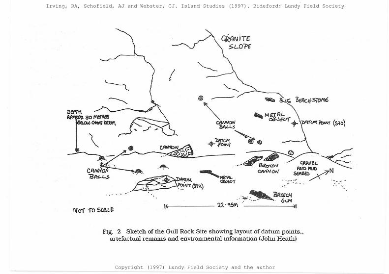
A second pre-disturbance survey was carried out under licence by John Heath and members of the Appledore Sub-Aqua Club in 1993 to record the site and its environment more accurately and to compile a photographic record of artefacts. The team established a detailed site plan of the visible features of the site, namely eight 5" limestone cannon balls, two wrought iron cannons, and one breech gun (Fig. 2) along with some material of a more recent date which possibly originates from other wrecks nearby.
Lundy's other officially protected wreck is the Clyde-built paddle steamer PS Iona II. Built in 1863 at Govan as a fast ferry for use around the Clyde coast, with an overall length of 245 feet, a beam of 25 feet, draught of 9 feet, paddle wheels 20 feet in diameter, and a twin cylinder oscillating engine of revolutionary
Irving, RA, Schofield, AJ and Webster, CJ. Island Studies (1997). Bideford: Lundy Field Society
Copyright (1997) Lundy Field Society and the author
ISLAND STUDIES
design, this ship was capable of a top speed of 24 knots. Shortly after her construction, the ship was bought by Charles Hopkins Boster of Richmond, Virginia allegedly to break the Federal blockade of Confederate supply routes during the American Civil War. Although initially well decked out, the PS Iona II was stripped for her first trans-Atlantic voyage in 1864 and was loaded with enough coal for the long voyage from Glasgow to Nassau, a voyage for which the ship was not well suited. Her narrow clipper-like hull design with shallow draught and flat bottom would have made her very unstable in the steep seas of the north Atlantic. In the event, under the command of a Captain Chapman, the PS Iona II sank off Lundy but her 39 man crew were saved, and taken to llfracombe (Farr 1967). Eye witness accounts of the day told of salvage operations in progress using a diving bell. Nevertheless, the wreck of the PS Iona II was still fairly intact when she was relocated during a search for the nearby wreck of the MV Robert in 1976. Divers salvaged material from the wreck, some of which has been deposited in Greenock Museum.
Iona II was designated in 1989 under,the Protection of Wrecks Act 1973 because of the revolutionary design and function of the vessel and the intact condition of her engineering. The gradual deterioration of her hull and paddle wheel assemblies, caused mostly by corrosion of her iron fittings in seawater but exacerbated possibly by the trawling of fishing gear over her hull, prompted the need for a baseline survey to be
81
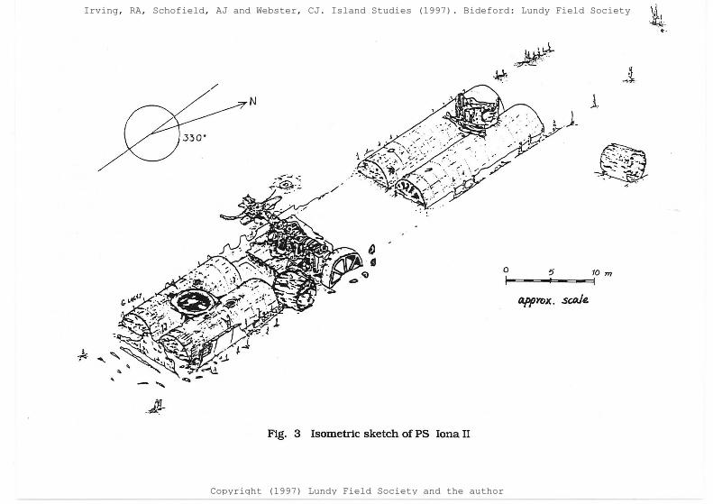
undertaken. The first work was undertaken in 1990 by Potters Bar Sub-Aqua Club under the guidance of Nick and Carol Rule (Rule 1991). With the aid of secondary video footage, stills photography, and the original ship plans, Carol Rule compiled a detailed isometric sketch of the ship as she lies on the sea-bed (Fig. 3). As the diagram shows, the PS Iona II remains fairly intact, consisting of hull ribs and plating at the bow and stern of the ship protruding from a sandy gravel sea-bed, with remains of the coal cargo, intact boilers, twin cylinder oscillating engine and paddle wheel drive shaft clearly visible.
No survey measurements were taken to compile the isometric sketch so in 1995 , and 1996, Philip Robertson led two field school expeditions of members of the Nautical Archaeology Society with the aim of compiling baseline measurement data, using tapemeasures, and photographic recording. The resulting data is currently being used to enhance the isometric sketch so that it can be re-drawn to scale and this final record will be useful as a baseline with which to assess deterioration of the wreck as seen during future visits to the site, as well as for interpretation as part of the activities of the Marine Nature Reserve.
Under the Protection of Wrecks Act 1973, diving on the Gull Rock Site and PS Iona II is limited to holders of a survey licence issued upon application to the Department of National Heritage. Although those diving on a designated site without a licence are committing a criminal offence and can be prosecuted,
Irving, RA, Schofield, AJ and Webster, CJ. Island Studies (1997). Bideford: Lundy Field Society
Copyright (1997) Lundy Field Society and the author
1Vo1" 1"0 Sc.AI..e
GRANiTE S,.L01'£
. .- ·~'!'"-~BR~~ K------- ll: q!i/Y\ ·-----~
Fig. 2 Sketch of the Gull Rock Site showing layout of datum points .. artefactual remains and environmental information (John Heath)
·- .....
Irving, RA, Schofield, AJ and Webster, CJ. Island Studies (1997). Bideford: Lundy Field Society
Copyright (1997) Lundy Field Society and the author
ISLAND STUDIES
unlicensed local charter boats and diving clubs frequently dive PS Iona II. On the other hand, they are apparently causing little damage to the wreck and most respect the importance of leaving the site untouched. This situation is clearly unsatisfactory. With the introduction of a trial 'open day' on the wreck in 1996 enabling controlled access to visiting divers, it appears that the stance of the regulatory body for the Protection of Wrecks Act 1973 - the Advisory Committee on Historic Wrecks, may be warming to the idea of visitor schemes. It must be hoped that Lundy may move to a position whereby the Warden will be allowed to facilitate legal access to the wreck to visitors on the grounds that they are provided with educational material about the wreck and about the importance of conserving Lundy's shipwrecks for the future.
While the two wrecks discussed above are Lundy's most important wrecks and have received most attention from archaeologists, an overall assessment of the importance of the island's other wrecks was undertaken in 1994. Using tick-in-the-box recording forms being jointly promoted by the Nautical Archaeology Society (NAS) and the Royal Commission on the Historical Monuments for England (RCHME}, 'a team of divers led by Philip Robertson completed basic assessments of most of the known wrecks. All the sites surveyed were of post-medieval or of modern date, and most are of iron construction. Their condition varies from intact (MV Robert) to semi intact (PS Earl of Jersey). broken up (SS Carmine Fllomena, HMS
83
Montagu) and scattered (SS Salado, Amstelstroom, Heroine). The famous Duncan class battleship HMS Montagu, wrecked at Shutter Point in 1906, would have been of significant importance but commercial salvage and the quick disintegration of her hull have diminished this. None of the others are of national archaeological importance but they are of local interest because studying them helps build up a picture of trade and maritime activity in the Bristol Channel. For instance, several of the ships wrecked around Lundy were engaged in the coastal and international trade in coal from the ports of SW Wales which was so important to the economy of the Bristol Channel area. One such example was SS Carmine Fllomena, a steam driven Italian cargo vessel of 5,287 ton displacement carrying a cargo of coal to Genoa from Cardiff. The steampowered SS Salado lost in fog in 1897, and the single screw coaster MV Robert capsized off Lundy in 1975, were also involved in the coal trade.
On the MV Robert, the intact hull, deck railings, windlass wheels and air vents have all become adorned with marine life, providing an artificial haven for plumose anemones Metridium senile, conger eels Conger conger, lobsters Homarus gammarus, and shoals of bib Trisopterus luscus and frequent wrasse (Labridae). Many of Lundy's other wrecks are also of great value to nature conservation (see also Hiscock, this volume). Of particular note, biological surveys have identified communities of the phoronid worm Phoronis hippocrepia on the limestone cannonballs of
Irving, RA, Schofield, AJ and Webster, CJ. Island Studies (1997). Bideford: Lundy Field Society
Copyright (1997) Lundy Field Society and the author
~-·-
/
0 5 t""'"'~oc=...;,=-- 10 m
Fig. 3 Isometric sketch ofPS Iona 11
Irving, RA, Schofield, AJ and Webster, CJ. Island Studies (1997). Bideford: Lundy Field Society
Copyright (1997) Lundy Field Society and the author

ISLAND STUDIES
the Protected Wreck at Gull Rock, consistent with limestone bedrock in other parts of the country, but not occurring elsewhere under water around Lundy (Irving et al. 1995). It seems that by the artificial introduction of a limestone source into the area, a unique localised habitat has been created.
In conclusion Alongside Lundy's renowned clear waters and rich marine habitats, it is the scenic qualities of the wreck of MV Robert, and the history surrounding the sinktugs of the PS Iona II, and HMS Montagu, that attracts so many sport divers to Lundy. The island's wrecks also provide a rich artificial habitat for marine life increasing the diversity of the vital marine ecosystem of England's only Marine Nature Reserve. Marine archaeologists have a role to play in recording sites and in promoting the importance of conserving Lundy's shipwrecks in the face of intentional human interference: the stripping of historic wrecks for commercial gain, and the casual souvenir hunting that threaten the future of many of the UK's most interesting wrecks. The problem is that archaeological sites are non-renewable; once a wreck has gone, it has gone forever.
As diving around Lundy becomes more popular with the growth of the sport in the rest of the UK, more wrecks will be located and the true archaeological potential of the waters of Lundy will become clearer. Several useful steps can be taken to further knowledge
85
in the short term. A programme of remote sensing research off the island's east coast using techniques such as side-scan sonar and magnetometry combined with visual confirmation by remote operated vehicles (R.O.V.) would help to identify shipwrecks which have yet to be found by divers. Diving fieldwork should concentrate on monitoring the Gull Rock Site and PS Iona II protected sites to assess change to each. In the case of the PS Iona II, it would be possible to undertake corrosion potential studies on selected parts of the wreck to identify whether anything can be done in situ to conserve the ship. There would be no advantage in lifting or excavating any of the wrecks within Lundy's waters but research from Australia and elsewhere in the UK suggests that large iron wrecks like PS Iona II can be partially conserved on the sea-bed, for instance using sacrificial anode protection. The best museum for Lundy's underwater heritage is the sea-bed itself, where divers may continue to visit these memorials to the island's maritime history, and marine life can continue to thrive in an environment that is all the more diverse for the presence of these enriching artificial habitats. Let us promote the waters off Lundy as a flagship for the sustainable management of our underwater heritage, to be a shining example for the rest of the UK and Europe.
Irving, RA, Schofield, AJ and Webster, CJ. Island Studies (1997). Bideford: Lundy Field Society
Copyright (1997) Lundy Field Society and the author
86 MARINE ARCHAEOLOGY AND LUNDY
Acknowledgement The authors would like to thank Steve Waring, of the Royal Commission on the Historical Monuments of England, for his contribution towards this paper.
References Bouquet, M 1967, Lundy Shipwrecks. Annual Report of the Lundy Field Society 18, 19-23. Bouquet, M 1969, More Lundy Shipwrecks. Annual Report of the Lundy Field Society 20, 22. Davis, R 1962, The Rise of the English Shipping Industry in the Seventeenth and
Eighteenth Centuries. Newton Abbott. English Nature 1994, Managing Lundy's Wildlife: a management plan for the Marine Nature
Reserve and Site of Special Scientific Interest. Okehampton: English Nature. Farr, G 1967, West Country Paddle Steamers. London. Gibson, C 1993, Lundy Shipwrecks Map. Lundy. Heath, J 1991, 'Diving around Lundy'. Lundy Field Society Newsletter 21, 4-5. Irving, R A, Holt, R & Moss, D 1995, Selected reports from the Marine Conservation Society's diving working
party to Lundy, 3-10 June 1995. Annual Report of the Lundy Field Society 46, 54-65 Langham, A F 1994, The Island of Lundy. Stroud: Alan Sutton. Lam, Rand B 1995, Shipwreck Index ojthe British Isles. Lloyd's Register of Shipping. Rule, N 1991, 'Potters Bar Sub-Aqua Club 1990 Survey ofiONA II' Nautical Archaeology Society
Newsletter 1, 8-9.
Further Reading DuffY, M 1992, The New Maritime History of Devon 1. Conway Maritime Press, London. DuffY, M 1994, The New Maritime History of Devon 2. Conway Maritime Press, London. Robertson, P. 1994. Marine archaeology and Lundy Marine Nature Reserve- an assessment.
Annual Report of the Lundy Field Society 45, 57-76. Throckmorton, P. (ed.) . 1987. Historyjrom the Sea. London.
Irving, RA, Schofield, AJ and Webster, CJ. Island Studies (1997). Bideford: Lundy Field Society
Copyright (1997) Lundy Field Society and the author
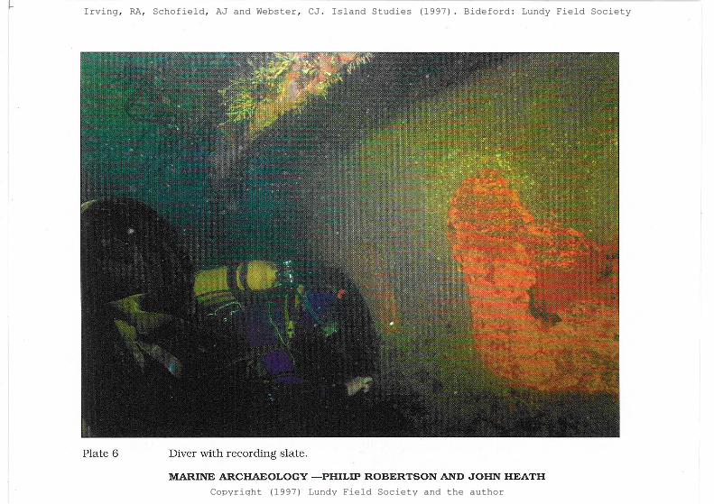
Plate 6 Diver with recording slate.
MARINE ARCHAEOLOGY - PHILIP ROBERTSON AND JOHN HEATH
Irving, RA, Schofield, AJ and Webster, CJ. Island Studies (1997). Bideford: Lundy Field Society
Copyright (1997) Lundy Field Society and the author
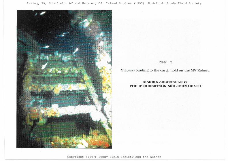
Plate 7
Stepway leading to the cargo hold on the MV Robert.
MARINE ARCHAEOLOGY PHILIP ROBERTSON AND JOHN HEATH
Irving, RA, Schofield, AJ and Webster, CJ. Island Studies (1997). Bideford: Lundy Field Society
Copyright (1997) Lundy Field Society and the author