mardon skipper surveying · 2015-09-02 · l. miller - 4 entire time with the forest service, to...
TRANSCRIPT

Mardon Skipper (Photo Credit Mike Miller)
Mardon Skipper Surveying
Internship with
USDA Forest Service
Submitted by
Lily Miller
Towards fulfillment of the Capstone in Geography
Western Oregon University
Approved by:
___________________________________________________________ Date: ______________________
Advisor: Mark Van Steeter
L. Miller - 2
Table of Contents
INTRODUCTION .......................................................................................................................................................................... 3
ABSTRACT .................................................................................................................................................................................... 4
STATEMENT OF RESEARCH QUESTION ............................................................................................................................. 4
CONSERVATION AND SPECIFIC SPECIES – THE MARDON SKIPPER A LITERATURE REVIEW ........................ 5
METHODS .................................................................................................................................................................................. 15
REQUIRED EQUIPMENT ................................................................................................................................................................................ 15 AERIAL PHOTOS............................................................................................................................................................................................. 15
Historical Aerial Photo Cleaning and Organization .............................................................................................................. 15 MARDON SKIPPER SURVEYING EFFORTS .................................................................................................................................................. 16
Surveying Methods .............................................................................................................................................................................. 16 BALD EAGLE SURVEYING ............................................................................................................................................................................. 19 HABITAT RESTORATION AND ENHANCEMENT ......................................................................................................................................... 19
Native Grass Seed Collection ........................................................................................................................................................... 20 Meadow Restoration .......................................................................................................................................................................... 20 Invasive Plant Extraction ................................................................................................................................................................. 20
WEB SOIL SURVEY QUERY ........................................................................................................................................................................... 21
RESULTS ..................................................................................................................................................................................... 22
AERIAL PHOTOS............................................................................................................................................................................................. 22 MARDON SKIPPER SURVEYING EFFORTS .................................................................................................................................................. 22
Windy Valley Meadow ....................................................................................................................................................................... 22 Snow Camp Meadow .......................................................................................................................................................................... 22
BALD EAGLE MONITORING .......................................................................................................................................................................... 23 HABITAT RESTORATION AND ENHANCEMENT ......................................................................................................................................... 23 WEB SOIL SURVEY QUERY ........................................................................................................................................................................... 24
DISCUSSION............................................................................................................................................................................... 26
CONCLUSION ............................................................................................................................................................................. 30
REFERENCES ............................................................................................................................................................................. 31
APPENDIX .................................................................................................................................................................................. 34
CONTACT AND AGENCY INFORMATION ...................................................................................................................................................... 34 COORDINATES ................................................................................................................................................................................................ 34 DATA: BALD EAGLE, MARDON SKIPPER, WEB SOIL SURVEY ................................................................................................................ 35
Bald Eagle Surveying Efforts .......................................................................................................................................................... 35 Mardon Skipper Surveys ................................................................................................................................................................... 36 Web Soil Survey Query ....................................................................................................................................................................... 37
JOURNAL ENTRIES ......................................................................................................................................................................................... 38 LIST OF TASKS AND PROJECTS .................................................................................................................................................................... 43 MARDON SKIPPER SURVEYING DATASHEET ............................................................................................................................................. 44
ACKNOWLEDGEMENTS ......................................................................................................................................................... 45

L. Miller - 3
Introduction
The summer of 2013, I spent in Gold Beach, Oregon working with the USDA Forest
Service as part of the wildlife department’s crew. As a temporary summer employee, many
tasks and projects were asked of me to have completed before the end of the summer
season. The summer months are when most of the field work at this station can be
completed due to weather conditions the remainder of the year. Through all the tasks and
participation in projects, better understanding of nature and the outdoor world has been
gained, while also working to understand the significance of human-environment relations.
The broad spectrum of knowledge that the subject of geography covers, applies to
the multidisciplinary nature of the experiences I had with the Forest Service. The
multifaceted nature of the subject field allowed for each task to be approached with a goal
to connect what I was experiencing and observing while working to what I had learned
from my courses at Western Oregon University. For example, I used the skills I learned in
Map Reading and Analysis to organize historical aerial photos, circa 1940’s. While cleaning
and organizing, curiosity took over and I started comparing the historic photos to more
recent ones and discovered how much the landscape has changed. Then I started thinking
about why? What are some of the possible explanations of why it has changed? What could
have the past environment been like when compared to the current one? To answer these
questions I took information from courses like Physical Geography, Biogeography, even
Earth Science.
The acknowledgement and management of conservation is important to the
different departments of the USDA Forest Service. Most relevant to me is the wildlife
department. Some of the tasks and projects that I took part in were meadow restoration
and enhancement, bald eagle surveys, and Mardon skipper surveys. A more complete list of
tasks and projects can be found in the Appendix. The Mardon skipper is a rare and sensitive
butterfly. Researchers use population surveys as the main sources of species and habitat
health indication. Because of this population surveys and other projects relating to this
species were my main focus for the summer. This butterfly has a small window of
opportunity when people are able to survey and monitor them. Due to this and the fact that
as a summer employee, many other tasks were asked of me and I was not able to use my
L. Miller - 4
entire time with the Forest Service, to devote to Mardon skipper surveying efforts. In the
end, though, I was able to draw on all my experiences through work and schooling, to
develop a well-rounded project that considered the multiple aspects of an ecosystem or
environment that affects the survival of the Mardon skipper.
Abstract
There are several aspects that make the Mardon skipper unique and possibly an indicator
species. It is a rare butterfly that is affected by fragmentation and is greatly isolated. It is
endemic to the Pacific Northwest of North America and is limited to four populations that
are in Washington, Oregon, and northern California (Miller & Hammond; pp. 39-40, & 68).
It is considered to be a relict (Miller and Hammond; pp. 39-40) and the remaining habitats
could possibly be ‘”islands,” microclimates, and/or refugia that are just as unique as the
butterfly itself. By surveying and monitoring the current populations of the Mardon
skipper, we are able to learn of relationships between habitat change and species response.
Statement of Research Question
Originally my research plan was focused on identifying aspects of Mardon skipper habitat
in currently populated sites and from there, identifying new potential habitat. However,
through my experiences and further education, the focus of the project has become more
about expanding Mardon skipper survey efforts and exploring aspects that were not
previously recognized. From the results of my work, I gained a better understanding of
whether or not, the Mardon skipper species is an indicator organism, an organism that
points to the health of an ecosystem or environment. It is similar to how a bald eagle
population will indicate the health of the waterway in which it depends on and the health
of the fish, its food source.

L. Miller - 5
Conservation and specific species – the Mardon skipper
A Literature Review
The world has always been changing and reorganizing but recently it has been more
rapid with greater impacts. According to Cox and Moore “[T]he loss of global biodiversity
that we are currently experiencing may well be affecting the functioning of the entire
biosphere” (Cox & Moore; p. 100). Any loss has an effect on the ecosystems, and concepts
of conservation and its management are becoming more and more relevant. Changes such
as global warming and human disturbance all cause changes, which are stressful for the
creatures that live in affected habitats, or ecosystems. Making up “95% of all animal life in
terrestrial environments” arthropods and insects “are highly sensitive to environmental
change, both climate and habitat modification” (Miller & Hammond; p. 15). Because of this
researchers can learn through observations of arthropods and insects about the habitat
that is associated with that organism (Beyer & Schultz, 2010) by “serv[ing] as an indicator
organism for … health, diversity, and sustainability of the environment” (Miller &
Hammond; p. 15).
The Mardon skipper is a rare butterfly species that is found in the Pacific Northwest
region of the United States, noted by Hatfield, Hoffman Black, and Jepsen (2013b), the
authors of Range-wide strategy and monitoring protocol for the Mardon skipper (Polites
mardon, W.H. Edwards, 1881). According to NatureServe (2013) the conservation status
of the Mardon skipper is imperiled, which means it is at risk of becoming endangered. The
species is already listed as endangered in the state of Washington, and imperiled in Oregon.
Is it possible that the Mardon skipper is an indicator species? If so what is it indicating?
Through a review of the literature, it is revealed that conservation is relevant and is going
to be increasingly important for the world’s biosphere. Acknowledging the fact that
conservation efforts are need for several habitats and species, Mardon skipper included.
Threatened and Endangered Species and Conservation
Goble, Wiens, Scott, Male, and Hall (2012) stated “The accumulated effects of
individual and societal actions, taken locally over centuries, have transformed the
composition, structure, and function of the global environment.” Things have changed so
L. Miller - 6
much that ecosystems and species are becoming threatened, imperiled, endangered, and
even extinct. When a species becomes so threatened it has potential to become extinct, it is
considered an endangered species (Raven, Berg, & Hassenzahl, 2010, pp. 375-376). To
respond to the “endangerment and loss of species” the Endangered Species Act (ESA) is to
“bring species at risk of extinction ‘to the point at which the measures provided pursuant to
this Act are no longer necessary’” (Goble et al., 2012).
Species are being threatened and endangered all over the world. Fattorini (2009)
assess species threats at different spatial scales using a “three-step analysis:”
In the first step, species are assigned to categories of threats at larger (e.g.
continental) scale. Then in the second step, the species are assigned to categories of
threats at a smaller (e.g. country) scale. Thus the conservation status of a given
species is evaluated at two spatial scales … In the third step, areas which host
species that are imperiled at the ‘larger’ scale, but not at the ‘smaller’ scale, can be
considered as priority areas where conservation efforts are expected to be more
effective. (Fattorini, 2009)
This analysis allows conservation efforts to be better designed. The authors, Thomas,
Franklin, Gordon, and Johnson (2006) concluded their research review by providing
“suggestions for better achieving the goals of the NWFP,” Northwest Forest Plan, a
conservation plan that is specific to the United States of America’s Northwest region, for
old growth forests and associated species. One of the suggestions that I would like to draw
attention to is, to “manage the NWFP forests as dynamic ecosystems.” When looking at
“species-specific protection on endangered, threatened, and at-risk species” the authors,
Thomas et al., turned to coarse- and fine- filtered approaches. The coarse-filtered approach
is “the occurrence of species is predicted by the occurrence of habitat,” and will maintain
species diversity through ecosystem diversity over large areas (Thomas et al., 2006). The
fine-filtered approach is “based on actual site specific data,” and is more appropriate for
“federally threatened and endangered species” (Thomas et al., 2006). The fine-filtered
approach also recognizes the importance of the habitats of the species that are in question
(Thomas et al., 2006).
Summers, Bryan, Crossman, and Meyer (2012) suggest that “there is a need to
reduce the vulnerability of native … species through a range of conservation measures” that

L. Miller - 7
will aid in adaptations needed due to climate changes for the “most sensitive-species.”
Miller and Hammond (2007; p. 3) state that “[i]f climatic conditions change to such a
degree that the habitat suitable for a species also changes, then the species will likely be at
a higher risk of extinction.” Conservation considers both the organisms and their habitats,
in order to assist in the success of the species and ecosystems. Conservation is defined by
“The American Heritage Science Dictionary” (2013) as “[t]he protection, preservation,
management, or restoration of natural environments and the ecological communities that
inhabit them.” The conservation of habitats or species, plant or animal, is important
because it preserves biodiversity. Biodiversity is the “variation among organisms” and
accounts for species richness, genetic diversity, and ecosystem diversity (Raven et al. ,
2010, p. 371). A healthy ecosystem requires biodiversity of the species within it, and when
a species or whole habitat is lost, biodiversity is lessened.
Unique Characteristics and Landscape
Ecosystems all over the world have their own characteristics that add to the
landscape. An ecosystem is “a system formed by the interaction of a community of
organisms with their environment” (ecosystem. Dictionary.com). Endemism is a
characteristic that is used to describe an organism that is found in a particular region, or
“confined in their distribution” (Cox & Moore, p. 39; Raven et al, 2010, p. 377; Strahler &
Strahler, 2005, p. 693). Endemism is “based on the distribution of a species being limited to
relatively well-defined population within a restricted geographical area… [or] localized
habitat of just a few square kilometer” (Miller & Hammond; p. 3). Another unique
charactistic that deals with spatial confinement is relict. A relict is “an organism that now
has a more limited distribution than it once had,” usually due to climate change (Cox &
Moore; p. 481). In other words a relict is an endemic organism that is even more restricted
in distribution and is often considered to be species remnant of time period or climate that
no longer exists to its previous extent. What is now left as a population and habitat could be
considered an example of microclimate and refugium.
Microclimates and refugium, can occur naturally but are pushed by both natural and
human influences. Microclimates are the most local level of habitat type, which can often be
L. Miller - 8
restricting, taking into considerations “the spatial environment within which an animal
feeds, moves around, shelters, lives, and breeds” (Cox & Moore; pp. 40, 127-128). There are
animals that only live within a microclimate, restricting their movement. A refugium is
similar to a microclimate, in a sense that they are both a localized habitat. Refugium,
(plural, refugia) is defined as “location[(s)] in which some organisms have been able to
survive a period of unfavorable conditions” (Cox & Moore; p. 481). These usually are areas
that are stable, meaning they do not have a lot of tectonic activity, glaciation, and don’t have
extreme weather conditions. Refugia are areas, or “’islands’” (Cox & Moore; p. 53), of
favorable conditions for survival. These are places were relicts usually show up because
the condition are similar to what their previous habitat would have been (Cox & Moore, p.
53).
These “islands” can occur when the world’s biosphere naturally changes but in
today’s world human factors have accelerated the process and have changed the landscape.
With all the changes that happen in the world, some species become indicator species. This
“refers to species that have such narrow ecological tolerance that their presence or absence
is … [an] indication of environmental conditions” (Hunter, p. 241). They “warn of a
problem” that could be happening in their environment (Hunter, p. 241). A species may be
indicating with subtle changes in their behavior or drastically with major population
changes. A characteristic that plagues landscapes today is fragmentation.
The fragmentation of habitat threatens so many aspects of ecosystems, especially
the organisms associated with them. Fragmentation can be caused by human influences
such as “agricultural and residential development, fire suppression, livestock grazing, and
introduction of exotic species” (Hoffman and Vaughan, 2013). This is because land is being
delegated for other reasons, instead of natural habitat. In a way fragmentation is a
ecosystems way of adapting to changing conditions. According to the authors of
“Environment,” habitat fragmentation is “the breakup of large areas of habitat into small,
isolated patches” (Raven et al., 2010 p. 377). These “isolated patches” could then be
considered refugia, because the way the world is changing favorable conditions in the
patches are what orgainisms are using to survive. Some creatures have had their habitat
changed so much that they then become relicts.

L. Miller - 9
The concept of the “island” describes the isolation of a particular habitat, which is
similar to how an island in an ocean provides a terrestrial habitat in a marine environment.
“Islands” that occur in continental conditions are favorable habitat that species, both plant
and animal, use to survive in a changing environment. Isolation can occur by altitude. There
are several climate changes as altitude increases, and with that ecosystems change too.
“Species that are found only with a narrow altitudinal belt are particularly sensitive to
isolation, fragmentation, and reduction of their habitat” (Olson, Noss, Orains, Striholt,
Williams, & Sawyer; n.d.). Looking at a profile of a landscape by elevation, a person will
notice that there are environmental changes. Increases in elevation, will change the
temperature and moisture levels, which in turn changes the type of habitat and climate that
are present. According to Briles, Whitlock, Bartlein, and Higuera (2008), “[s]teep elevation
gradients created by mountains transform large-regional scale climate patterns into site-
specific microclimates in which different aspects and elevations strongly influence
vegetation.” Sometimes “islands” and refugia occur at different altitudes because they are
dependent on the conditions that are present at those certain elevation. A certain elevation
may promote the survival for a particular habitat and therefore the survival of the species
within it. Ecosystem adaptation and accelerated process from human influence can be a
cause of fragmentation but there are also other situations that lead to fragmentation.
The Pacific Northwest is an area that is, sometimes, still regarded as wild and
untamed, where wildfires are a natural occurrence. The major difference is in the past they
were not as severe. When natural occurrence of fire is suppressed, several things happen as
a result. Miller and Hammond explain the situation and consequences of fire suppression
and encroachment.
Under controlled conditions, the disturbance caused by fire is beneficial to the biota.
Conversely, catastrophic fires are detrimental to the biota. Prolonged periods of
time without fire will result in tree encroachment into meadows and other types of
clearings and promote a more dense growth of the understory vegetation. In turn,
the understory shrubs and trees outcompete species of sun-loving grasses and
herbs. (Miller & Hammond, p. 3)
Encroachment is major threat to habitats because it causes fragmentation and isolates
environments. Beyer and Schultz (2010) tell that “Forest encroachment not only reduces
L. Miller - 10
the amount of open habitat but [also] closes off corridors between meadows.” The closing
of corridors makes it impossible for animals and plants to expand without immediate
threat (Raven et al., 2010, p. 386). As the climate changes, plants and animals need to be
able to adapt and follow their habitat movement, otherwise they may be threatened with
extinction.
One way to offset isolation and fragmentation is to have corridors. A corridor is
defined by Cox and Moore (2010) as “a pathway [that] may include a wide variety of
interconnecting habitats, so that the majority of organisms found at either end of the
corridor would find little difficulty in traversing it” (p. 42). According to Strahler and
Strahler (2005, pp. 692-693) corridors, or landscape fluidity (Summers et al. , 2012),
“facilitate” movement of species. “In order to survive … species will need to migrate …
[making] landscape fluidity necessary” (Summer et al., 2012). Summer et al. (2012) also
states, “Species that are unable to overcome these barriers and migrate to new areas will
become increasing isolated … [making them vulnerable] to climate change.” Corridors
connect the landscape in way that can assist in the survival plant and animal species, but it
depends on range, or area need for an individual to complete life cycle, of the species
(Hunter, pp. 129-130).
Mardon Skipper (Polites mardon)
“First described by W.H. Edwards” in 1881 from H. K. Morrison collected in 1880
(Hatfield et al., 2013b) the Mardon skipper is part of the taxonomy order, Lepidoptera, or
butterflies and months, which is “one of the largest, most diverse, and most endangered
taxonomic groups” (Beyer & Schultz, 2010). “Mardon skippers were likely more
widespread and abundant” prior to the European settlers being in the area, revealed by
Hoffman Black, Vaughan, and The Xerces Society for Invertebrate Conservation. Now an
endemic species, the Mardon skipper is found in 21 sites in southern Oregon Cascade-
Siskiyou Mountains and even fewer in coastal regions of northern California and southern
Oregon (NatureServe, 2013). “Rare butterflies are … useful for monitoring unique
ecosystems and are often associated with other threatened fauna” (Beyer and Schultz,

L. Miller - 11
2010). As an indicator species, the Mardon skipper is so connected to its environment that
any changes will be forewarned by the butterfly (Hunter, p. 241).
Miller and Hammond (2007) identified six possible reasons why butterflies and
moths are rare.
1) the food plant for the caterpillars is also rare; 2) the species exhibits a narrow
range in its optimal climatic conditions, such as temperature and moisture
conditions, that limit the availability of suitable habitat; 3) natural enemies; 4) some
other species is superior interspecific competitor and utilizes a similar and limited
critical resource, such as the same food plant; and 5) the population is at the edge of
the species range and therefore is inconsistent in sustaining a colony through time…
The sixth factor is founded on insufficient sampling protocols for population
assessment… [contributing to the] perception that a species is rare. (Miller &
Hammond, 2007, p. 1)
With little information or population assessments on a species there isn’t a definite answer
regarding its status as rare or not. With a small amount of information it can be assumed
that a species is rare, because there is no evidence stating otherwise. With more
information, a species’ status has better background and support, so a question of rarity
can be answered definitively. This is why surveys and other efforts are done. They provide
additional knowledge to a limited, but growing, general knowledge of the Mardon skipper.
Specifically the Mardon skipper’s rarity is further expressed by its population
groups. A population group is an assemblage of individuals of the same species that
interact and exchange genetic material within a defined spatial area. The Mardon skipper
species only has four known population groups known only in Washington, Oregon, and
Northern California (Miller & Hammond; p. 39). The “four localized but widely disjunct [sic]
populations” appear to be relicts “from what was once a much more widely distributed
species in Western North America” (Miller & Hammond; p. 39). The four populations occur
in “Tenino Prairies of western Washington near Olympia,” summits of the Cascades around
Washington state’s, Mt. Adams, “along the summit of the Cascades in southern Oregon and
northern California,”, and “the Siskiyou and coastal mountains of Del Norte County … [and]
immediately to the north in Oregon within the Siskiyou National Forest, Curry County”
(Miller & Hammond, pp. 40 & 68). In the southern Oregon Cascade-Siskiyou Mountains, and
L. Miller - 12
adjacent coastal regions of northern California and southern Oregon there are only 21 sites
where the Mardon skipper is found (NaturServe, 2013). In the coastal regions of southwest
Oregon and northwest California, the research showed that that fragmentation is high and
“most [sites are] separated by a distance of over two miles” (Hatfield et al., 2013a), which is
too far for the Mardon skipper to travel. The fragmentation of the habitat is a major threat,
separating required Mardon skipper habitat. What once was a connected habitat
supporting life is now fragmented and has created “islands.”
The small number of sites where the Mardon skippers are found may be due to the
type of habitat that is preferred. The habitat itself may be a relict, making the species a
relict as well. The preferred habitat consists of moist, grassland areas, in serpentine based
soils (Hatfield et al., 2013a). “Serpentine is a relatively rare rock type, created when oceanic
mantle is emplaced on land typically at fault zones near continental margins” (Cooper).
This type of soil is also considered “toxic and nutrient poor” (Sleeter & Calzia). A species of
oatgrass, Danthonia californica, common name California oatgrass, is found in the
serpentine soil sites in Oregon. California oatgrass is most often used by the Mardon
skipper for ovipostion, or the laying of eggs (Dictinary.com Unabridged), as explained by
Beyer and Hoffman Black (2006). This is a species of oatgrass, along with fescue, native
bunchgrasses, and other grasses, that the Mardon skipper larvae and caterpillars feed on
(Hoffman & Vaughan, 2013; Miller & Hammond, p. 68). The grasslands that the Mardon
skipper depend on “have declined dramatically in the past 150 years due to agricultural
and residential development, fire suppression, livestock grazing, and introduction of exotic
species” (Hoffman & Vaughan, 2013).
The Mardon skipper has a body that is less than one inch, or 2.0 to 2.4 centimeters,
with tawny-orange hair (Hoffman Black & Vaughan), and a 2.8 centimeter wingspan (Miller
& Hammond; p. 68). In “Conservation assessment for the Mardon skipper (Polites
mardon)” by Kerwin (2011), other distinguishable characteristics are explained:
1) In the resting position, or “basking posture[,] … the forewings are held at a 45-
degree angle and the hind wings are fully spread”
2) A “series of 5 or 6 … adjacent spots” adorn the wings, with the middle being
“strongly rectangular”
L. Miller - 13
3) The “[b]orders between the orange and brown areas are generally more
diffuse[d]…,” meaning more drawn-out or spread
4) Being part of the Hesperiinae taxonomy family and subfamily (p. 3), Mardon
skippers “have a fast, skipping flight … [similar to] a stone skipping across water”
These characteristics are important to keep in mind because the flight periods of the
Mardon skipper overlap with other similar skipper species, which can be referred to as
look-a-like species. To aid in population counts, proper identification is indeed important,
because of the look-a-like species. Population counts, which are conducted during flight
periods, help researchers understand the health the Mardon skipper and associated
habitats.
The lives of the adult Mardon skipper are usually “between five days to two weeks”
(Hatfield et al. 2013b). “[F]emales deposit their eggs into native bunchgrass where they
hatch after 6 to 7 days. Larvae feed on fescue, oatgrass, and a variety of other grasses for
about 3 months, overwinter as larvae, then pupate in the early spring” (Hoffman Black,
Vaughan, & Xerces Society). Female butterflies, in general, are very selective when choosing
on “ovipostion location,” according to Beyer and Schultz. “Habitat factors … include host
plant species, host plant nutritional and chemical content, host plant size and structure, and
oviposition location microclimate” (Beyer & Schultz, 2010). The effects of environmental
changes on the butterfly are seen more easily when in the larval stage “due to their limited
mobility and restricted habitat requirements” (Beyer & Schultz, 2010). The most common
flight period is between May and July (Hatfield, Hoffman Black, Jepsen, 2013a; Hatfield et
al. 2013b).
The flight period is created by factoring together the incoherent nature of when the
adults emerge from the pupa stage, or “[m]etamorphosis, the process of changing for a
caterpillar into an adult” (Miller & Hammond, pp. 13-14). The flight period is influenced by
factors that have to do with location such as present population, weather conditions, and
elevation. “Sites with large populations may have a flight period that extends for more than
a month, whereas sites with small populations may have adults present for only ten or
fewer days” (Hatfield et al., 2013a; Hatfield et al., 2013b). Flight periods are further
influence by weather conditions. “Wet or cold conditions delay emergence and conversely,
warm, dry conditions promote earlier emergence” (Hatfield et al., 2013a; Hatfield et al.,
L. Miller - 14
2013b). Site locations that are in coastal regions are found “within the coastal fog belt”
(Kerwin). Due to the changing climate we live in weather conditions are less predictable
and more extreme. Making it more threatening for sensitive species and associated
habitats, consequently makes conservation of species and habitat more significant.
Conclusion
“Population growth, human health, and urbanization are increasingly seen to affect
forests, with reciprocal effects on human populations in both social and biological
dimensions” (Thomas et al., 2006). Many people see the different species that are in this
world as something that should be cherished. Many species have already gone extinct, and
many others are threatened and / or endangered. Protecting the biodiversity of different
ecosystems of the Earth and in conserving habitat and ecosystems, a person is helping
species like the Mardon skipper to survive. Studying species like the Mardon skipper, I have
come to realize that its sensitivity to associated habitats make it an indicator organism.
The Mardon skipper is so fine tuned to its habitat and surroundings any change will
affect it and there will be noticeable differences exhibited by the species. The Mardon
skipper already exhibits signs of a changing biosphere. It has shown that it is endemic to
the Pacific Northwest of the United States of America. It has also considered to be a relict
(Miller & Hammond, pp. 39-40), that depends on microclimates, refugia, and “islands.” The
species is also affected by human influences, fragmentation and encroachment.
The knowledge base for the Mardon skipper is slowly expanding and gaining more
and more. This species of butterfly holds its own kind of importance in the natural and
academic world. Conservation not only helps many different animals and habitats but it
also helps people understand what those species need and how the world is changing.
Understanding a species such as the Mardon skipper, can allow us to better understand our
world.

L. Miller - 15
Methods
Required Equipment
This is equipment that all the employees usually have when they work in the field. They use what
they need when it applies to the conditions they are working in.
Appropriate Clothing: long-sleeved
shirt, jeans or work pants, a hat when
appropriate
Compass
Ranger District Map
Eye Protection
Field 1st Aid Kit
Hard Hat
Keys to buildings and gates
Leather Work Gloves
Orange Work Vest
Sunblock
Work Boots
Walkie-Talkie / Radio
Water
Work Site Maps
Aerial Photos
Aerial photos are taken to enable a better understanding of the landscape. Each image shows
unique characteristics of the landscapes from the year the picture was taken. When comparing
photos from different years the trends in landscape change become noticeable.
A task that was asked of me was to gather, clean, and organize historical aerial photos from the
1940s. Materials that will be needed are: aerials photos, flight line map, previous knowledge of
aerial photo coding (used to organized by flight line)
Historical Aerial Photo Cleaning and Organization
Materials: Aerial photos from around the 1940’s, Box, Eraser, Flight line map, Notebook
paper, pen or pencil, Previous knowledge of aerial photo coding (used to organized by flight
line)
The goals for this project were to organize as much of a complete set of 1940’s aerial
photos, as possible. The general process includes: finding photos from around the 1940’s,
use eraser to remove and markings, then organize into a shipping box by flight line. Once
that process was completed the photos were then shipped off to be digitized.

L. Miller - 16
Mardon Skipper Surveying Efforts
Materials: District map, Identification book, Notebook and pencil, Work site maps and coordinates
1) Sites are determined from a reported sighting of the butterfly. Another way sites are found
is by doing exploratory surveys. This is done by choosing a site via satellite images, going to
the designated site and doing a general survey to see if any individuals are present.
The sites that I looked at were Snow Camp Meadow and Windy Valley Meadow.
Latitude & Longitude
Snow Camp Meadow: 42˚21’11.38”N; 124˚10’19.48”W
Windy Valley Meadow: 42˚19’53.56”N; 124˚8’59.19”W
2) On a district map identify work site, usually meadows. Having extra copies of maps of
specific work sites comes in handy when in the field. It allows the observer to make notes
spatially if needed.
3) Decide which surveying method (described below) will be used and gather materials.
4) Drive to location. Many of the sites require a walk/hike in, so go prepared.
5) Once in the meadow proceed with surveying method.
Surveying Methods
Catch and Release Surveying - Getting a positive identification
Materials: Butterfly net, Camera, Identification book, Glass observation jar with
lid, Work site maps, notebook and pencil
1) Start day’s record in notebook with pencil. Day’s date, weather
conditions, temperature, wind conditions, and any other noticeable
observations.
2) Objective is to catch a butterfly to identify and then release.
3) With the butterfly net attempt to catch a butterfly.
4) Once a butterfly is in the net, without causing harm or injury, get it into
the glass observation jar. Put the lid on but not all the way, so there is
still oxygen available.
5) Using the identification book, identify the butterfly. Take picture if
needed with camera.
6) Record in notebook for identified count.
7) Release butterfly.
8) Once back at the station type up identified count and report findings.

L. Miller - 17
Example: Windy Valley; Date: 6/20/2013; Mardon skipper: 12; Checkerspot:
5; Silvery Blue: 2; Admiral: 1; Fritillary: 6
Permanent Transect Surveying – Distance Surveying
This type of surveying method allows for consistent data to be collected. The
original transects were put in using “Range-wide strategy and monitoring
protocol for the Mardon skipper (Polites mardon, W.H. Edwards, 1881).” By Rich
Hatfield, Scott Hoffman Black, and Sarina Jepsen.
Materials: GPS unit, Flagging, Notebook, Pencil, Permanent Marker, Rebar, and
Mallet
Permanent Transect Installation
Materials: GPS unit, Flagging, Notebook, Pencil, Permanent Marker, Rebar,
Mallet, “Range-wide strategy and monitoring protocol for the Mardon
skipper (Polites mardon, W.H. Edwards, 1881).” By Rich Hatfield, Scott
Hoffman Black, and Sarina Jepsen., Transect Coordinates
1) Using the suggested coordinates in the “Range-wide strategy and
monitoring protocol for the Mardon skipper (Polites mardon, W.H.
Edwards, 1881)” plot rebar at the units.
The current transects at Windy Valley were installed by Rich
Hatfield, Candace Fallon, Jessie Dubuque, and myself. The transect
UTM coordinates follow.
Transect Length Easting Northing
1 57.979787 405285.112886 4687186.20724
405253.725627 4687284.362255
2 101.301405 405306.111304 4687179.037928
405314.561802 4687279.986249
3 103.051283 405329.387361 4687206.265792
405333.958506 4687264.065095
2) Use mallet to secure rebar in the ground.
3) If any adjustments need to be made record them in your notebook,
make sure to also record the new coordinates.

L. Miller - 18
4) On the flagging write what transect it is, at each end. For example:
Flagging on the rebar designating transect 1: TRANSECT 1
Flagging on the rebar designating transect 2: TRANSECT 2
Flagging on the rebar designating transect 3: TRANSECT 3
Distance Surveying
This survey technique is based on what is stated in “Mardon Skipper (Polites
mardon, W.H. Edwards, 1881) Rangewide Monitoring Protocol” by Rich
Hatfield.
Materials: Insect net, Glass or plastic observation jars, 2 people or a digital
voice recorder, Distance measuring pole, Data sheets, Pencil, Thermometer,
Wind gauge (Kestrel), “The Butterflies of Cascadia: A Field Guide to All the
Species of Washington, Oregon and Surrounding Territories” by Robert
Michael Pyle,
1) Before conducting any surveys, record the information at the top of
the datasheet (example on page 44). Should include site name, date,
cloud cover %, observer, temperature, wind speed, and start and end
time.
2) Randomly choose transect. This can be done by throwing a pencil
over your shoulder and survey the transect the pointed end is
bearing towards. Then designate the order of with survey transects
with continue. For example you start on transect 2, then move to
transect 1, and finish with transect 3.
3) Before walking each transect state aloud the designated number (i.e.
Transect 1), so it can either be recorded by the other person or a
digital voice recorder. Then proceed to walk transect.
4) Walk transect at a consistent pace, saying number of observed
skippers aloud and distance perpendicular from transect.
5) As the observer walks transect, they should be saying their detection
aloud for the digital voice recorder or have another person follows
them recording observations on data sheet.
6) Once at the end of transect observer should state ending of transect.
For example “End of Transect 1”

L. Miller - 19
7) Repeat steps 3-6 for rest of transects.
8) Once observations are done on transects, 10 or 10% of observed
butterflies need to be caught. This is done to determine ratio of
Mardon skippers to look-alikes, and, if possible, male and female
ratio of Mardon skipper. An example of this would be if you observe
100 skippers while walk transects, 10 skippers need to be caught.
Bald Eagle Surveying
The bald eagle is another indicator organism but is also on the federally protected list. By observing
them, a better understanding of their health and the ecosystem’s health.
Materials: Tri-pod, Telescope, Description of site (where to find the nest), Notebook, Pen/Pencil,
Map, Timer, Photo of nest site if available
1) When a nest is located and an observation site is determined, then observations can
proceed. Nests are usually located when tracking and observing a bald eagle.
2) Drive to site. Some require you to walk to the observation site.
3) Set up telescope in described spot and direction. Having a photo from a previous
observation helps with locating the nest(s).
4) Find nest in scope. A bald eagle’s nest can usually be found near the top of a tree, with some
tree foliage still above the nest for shelter.
5) Once the nest is found, record in notebook with pencil, the observations. Observations
should include time, date, duration of observation, behavior, number of animals observed,
weather, etc.
6) Start observation time and continue for 15 to 45 minutes.
7) If there are two observable nests at the observation location then repeat steps 3-5.
8) Pack up supplies and return to vehicle.
9) Type up observations, once in office, for each site and report findings.
Habitat Restoration and Enhancement
In order for species that depend on meadow habitats to survive sometimes restoration and
enhancement is needed. Species such as the Douglas-fir will easily over take a meadow if the chance
is present. Keeping the meadow open will benefit the species that depend on it, such as the Mardon
skipper.
L. Miller - 20
Native Grass Seed Collection
Native grasses are not always found in meadows and species, such as the Mardon skipper
depend on native grasses for ovipostion. Collecting native grass seed allows for the seeding
of areas where native grasses are absent.
Materials: District map, Knowledge of the grass species collecting, Knowledge of location of
collection, Paper grocery bag, Work site map,
1) Collection sites are determined by a positive identification of the grass species
2) On a district map identify work site, usually meadows or fields.
3) Locate work site on map, most likely a meadow or meadow complex, and drive to
location.
4) Identify which grass species that is being collected. In this case Danthonia californica
or California oatgrass.
5) While picking the seed, collect them in the paper grocery bag. The paper bag allows
for drier storage and easier transfer.
6) Once back at station deposit the day’s collection into appropriate location. There
were several locations where the Danothonia was found, with different soil types. To
make sure the seeds reproduced successfully based on soil type, the seeds that were
collected at a specific site are stored together. For example, collections from
serpentine soils were stored separately.
Meadow Restoration
Many meadows are having their natural habitat taken over by trees and other encroaching
species. Meadow restoration can include the reopening up of a meadow, such as taking out
encroachment. The easiest way to control encroachment is to catch it when the trees are
still small. Use pruners, preferably with the long handle, and also use a bow saw to cut down
the encroachment trees. If there are bigger trees that require a chain saw, make sure
someone who is trained and has the correct credentials, takes care of those trees. Make sure
trees are cut as close to the ground as possible.
Invasive Plant Extraction
Invasive plants are also taking over certain habitats where the species was not present
before. Before going to the site, be familiar with the correct ways to dispose of the plant. The
most useful tools for this are to use a weed wrench and/or a Pulaski. Each plant species has
different physical and growing characteristics. Some have really deep roots, while others

L. Miller - 21
have shallow root systems. Knowing which type you are dealing with is essential to
successful eradication. Be sure to remove as much as the root system and seeds (i.e.
thistles) as possible, to ensure there will be no future growth at the site.
Web Soil Survey Query
All plant life comes from the soils and all animal and insect life depends on plant life in one way or
another. A query on the soil information for Windy Valley meadow and Snow Camp meadow was
done in order to explore the possible differences in the two sites regarding the soil. There were
several things that were looked at and the results are stated and discussed on pages 24 to 29.
L. Miller - 22
Results
A full account of results is on pages 35-37 in the appendix.
Aerial Photos
There are significant differences of meadows when comparing different years. When looking at the
older photos it can be noticed that the meadows are larger and more open. Meadows and roads are
similar in the fact that they are open areas that can be over grown with vegetation and encroached
on. For example designated roads are more visible, but when comparing to later photos the road
become over grown with vegetation. These characteristics are similar to how meadows become
overgrown with encroachment.
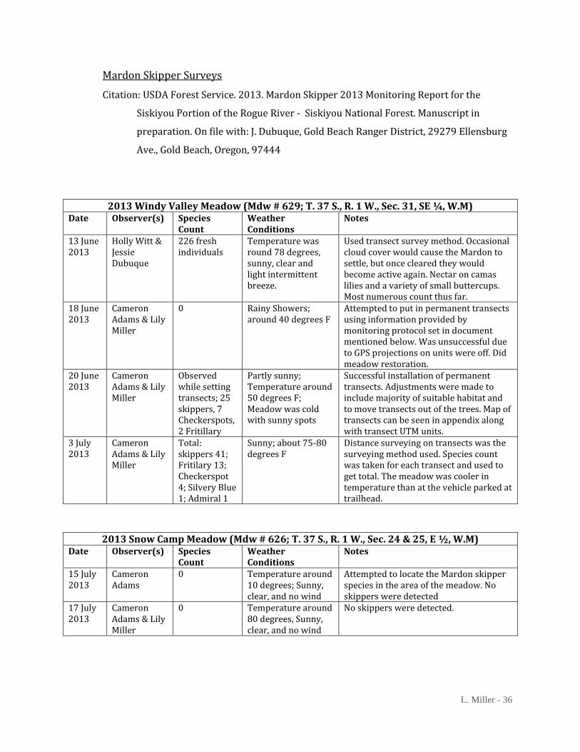
Mardon Skipper Surveying Efforts
Survey report on page 36
Windy Valley Meadow
This meadow was successfully surveyed in 2013. It was surveyed four times spanning June
and July. The first survey population count produced 226 individuals. A permanent transect
was installed on June 20, 2013, in accordance with the information provided in “Range-wide
strategy and monitoring protocol for the mardon skipper (Polites mardon, W.H. Edward,
1881) by Richard Hatfield, Scott Hoffman Black, and Sarina Jepsen. There were several
adjustments that needed to be made based on the knowledge of the site, and preferred
habitat. Adjustments were made, by me, to include as much of the preferred habitat as
possible, and to exclude the forested area around the site.
Recently, May 2, 2014, Rich Hatfield and Candace Fallon, accompanied myself and my
supervisor, out to the meadow. Hatfield relocated the previous installed transects and the
flagging for each was redone. We were also taught by Hatfield and Fallon how to
successfully complete a distance sampling survey, described in “Mardon Skipper (Polites
mardon, W. H. Edwards, 1881) Rangewide Monitoring Protocol” by Rich Hatfield. Distance
sampling survey and monitoring method will continue to be used.
Snow Camp Meadow
This was surveyed twice and no skippers were detected. There was, however, California
oatgrass present. This site is similar yet different from Windy Valley. The vegetation is
similar but there is more surface water present. Also more than half the area that would be

L. Miller - 23
Progress at the end of the first day
At the beining of work starting
Figure 1: Ludlum
Orchard. Showing the progression
of the restoration. Photo credit: Lily
Miller
Progress at the end of day 2
considered possible meadow on the map, is actually peat bog, with surface water running
just under the peat and organic matter. This area was also affected by the Biscuit Fire of
2002. From the characteristics of the meadow it looks as if there is a dozer line going
through meadow part of the area. In general this area seems much more disturbed than
Windy Valley meadow.
Bald Eagle Monitoring
This was successful year for
most of the known sites.
According to the bald eagle
monitoring summary that
looks at all observation data
collected, from 1982 to 2013,
an increase in the number
young that fledged is
displayed (USDA Forest
Service, 2013, Bald Eagle
Monitoring Report…).
Habitat Restoration
and Enhancement
There was work done in
Windy Valley meadow and at
Ludlum House Recreation
Site. That area has an orchard
nearby that was part of a
pioneer family’s settlement.
Over the years it has become
overgrown with
encroachment and invasive
plant species. Figure 1 shows
the progress of restoration

L. Miller - 24
from about the same vantage point.
Restoration of this particular meadow was important for several reasons. The first was historical.
This is part of a settlement of a pioneer family. This meadow/orchard is also used by elk, deer, and
bear. Further importance of the restoration here will be disscussed later.
The other meadow that I was able to work on was the Windy Valley meadow. This meadow is
secluded enough that invasive plants have a hard time getting there. There is some encroachment
but that can easily be taken care of when visiting the site.
Web Soil Survey Query
Soils information can be daunting and little overwhelming. One reason is that the terminology is
unusual for someone who is not used to it. But the information that the terminology provides is
important to understand, even if just the surface. The information that is used I believe will shed
light on a possibility why the two sites, Windy Valley meadow and Snow Camp meadow, are
different. To start with, soil comes from the breaking down of rock and the minerals in them. The
main ones that are a part of the soils that I will cover are igneous, sedimentary, and metamorphic.
Igneous rock forms from the “cooling and solidification of magma” (Soil Science Society of America).
Metamorphic rock is the reorganization of preexisting rocks due to pressure and heat (Soil Science
Society of America). Sedimentary rock forms when minerals and materials deposit and are “more
or less consolidated” (Soil Science Society of America).
Windy Valley Meadow had the following results:
(7D) Aquic Haplohumults-Cryaquepts complex, 0 to 15 percent slope
(29F) Bobsgarden-Rilea-Rock outcrop complex, conglomerate substratum, 30 to 60 percent
south slopes
(34E) Bobsgarden-Rilea complex, conglomerate substratum, 0 to 30 percent slopes
(54F) Cedarcamp-Snowcamp-Flycatcher complex, 30 to 60 percent south slopes
(262F) Threetrees-Saddlepeak-Scalerock complex, 30 to 60 percent south slopes
Snow Camp Meadow had the following results:
(7D) Aquic Haplohumults-Cryaquepts complex, 0 to 15 percent slope
(56F) Cedarcamp-Snowcamp-Rock coutcrop complex, 30 to 60 percent south slopes
(241E) Snowcamp-Cedarcamp-Rock outcrop complex, 0 to 30 percent slopes
(242G) Snowcamp-Flycatcher-rock coutcrop complex, 60 to 90 percent south slopes
Figure 2, on the next page, shows the layout of the soils present.

L. Miller - 25
They all have different characteristics that make them unique from each other. With each site
having different soil types can cause the sites to be different as will be discussed later.
Snow Camp
Meadow off of
the Web Soil
Survey site.
Windy Valley
Meadow off
of Web Soil
Survey site.
Figure 2 (Images from USDA Web
Soil Survey site)

L. Miller - 26
Discussion
The natural development of the world and its biosphere, are always changing and in
today’s world things are changing faster. The world and its ecosystems, adapt to the
different characteristics that are now present. The species, both plant and animal, within
the ecosystems now have to adjust too.
Changes in the climate alter ecosystems either in a good way or a bad way. For example
when looking at the aerial photos, meadows were more open in the past and over the years
it can be seen that encroachment has slowly taken over. It has also been noted several
places that climate has been on a warming trend for years now. The warming trend and
encroachment could be correlated. Encroachment is when the trees invade on a meadow or
open space. When this happens they are taking essential habitat of other plant and animal
species. When participating in habitat restoration and enhancement projects, preservation
of habitat and species was observed. For example when I participated in the Ludlum
Orchard restoration project, we were creating more suitable habitat for deer, elk, and bear,
while also preserving the apple trees from the pioneer family. By taking care of meadow
encroachment, such as at Windy Valley meadow, plant and animal species are able to
sustain their life cycles and be successful.
The successfulness of an species is often determined by the health of its habitat, and
indicator species generally tells of the health of their habitat and ecosystem. A great
example of this is the bald eagle. This species of bird relies on the river or waterway
ecosystems. And when there is something wrong with that ecosystem the bald eagle is
affected. In the past, rivers of the Pacific Northwest were over fished or deadly chemicals
(insecticides and pesticides) were leached in to waterways, making the aquatic species
suffer. In both of these situations the bald eagle suffered. But according to the general trend
that can be seen when looking at the number of young fledged a year since 1982, things are
moving in a positive direction (USDA Forest Service, 2013, Bald Eagle Monitoring Report…). The
number of successful young fledglings has increased since the start of the recordings of
monitoring activities. In the end it can be said that an individual bald eagle is an indicator
organism for the ecosystems, and the health of the fish, that it relies on.
L. Miller - 27
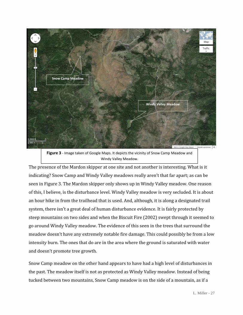
The presence of the Mardon skipper at one site and not another is interesting. What is it
indicating? Snow Camp and Windy Valley meadows really aren’t that far apart; as can be
seen in Figure 3. The Mardon skipper only shows up in Windy Valley meadow. One reason
of this, I believe, is the disturbance level. Windy Valley meadow is very secluded. It is about
an hour hike in from the trailhead that is used. And, although, it is along a designated trail
system, there isn’t a great deal of human disturbance evidence. It is fairly protected by
steep mountains on two sides and when the Biscuit Fire (2002) swept through it seemed to
go around Windy Valley meadow. The evidence of this seen in the trees that surround the
meadow doesn’t have any extremely notable fire damage. This could possibly be from a low
intensity burn. The ones that do are in the area where the ground is saturated with water
and doesn’t promote tree growth.
Snow Camp meadow on the other hand appears to have had a high level of disturbances in
the past. The meadow itself is not as protected as Windy Valley meadow. Instead of being
tucked between two mountains, Snow Camp meadow is on the side of a mountain, as if a
Snow Camp Meadow
Windy Valley Meadow
Figure 3 - Image taken of Google Maps. It depicts the vicinity of Snow Camp Meadow and
Windy Valley Meadow.

L. Miller - 28
bench in the landscape. It is easily accessible from a road and is visible from Snow Camp
Lookout. Where the soils that aren’t saturated with water, they appear to be quite dry as
well as the vegetation. California oatgrass, Danthoian Californica, is present in this meadow.
This native grass species is used by the Mardon skipper to deposit their eggs and feed the
larvae and caterpillars. But the level of disturbance in this area could possibly be too much
for the butterfly to have survived. There appears to be an old dozer line going through
Snow Camp meadow. The dozer line is a fire fighting technique and was possibly used
during the Biscuit Fire. This tells an observer that there was a high level of human
disturbances in past. Today there isn’t a great deal of disturbances but past ones have
contributed to the current state of the meadow and the possible reason why the butterfly
has not been detected in this meadow.
A major telling point in the mystery of these two sites is their soil. There are aerial images
of the meadows from the Web Soils Survey site on page 25.The area of the meadows at
both sites is Frigid Aquic Haplohumults (7D). The describing words frigid and aquic mean
that there is water present and it is cold. According to the Soil Science Society of America,
aquic conditions have characteristics such as soil saturation that create an aerobic
situation. This type of soil, aquic haplohumults, mostly found in Oregon, is “developed in
sediments derived largely from basic rocks” (Soil Survey Staff, pp. 740-741). According to
the Soil Survey Staff that wrote “Soil Taxonomy: A Basic System of Soil Classification for
Making and Interpreting Soil Surveys,” this soil has been “cleared for hayland, pasture, or
cropland” (pp. 740-741). When looking at this fact it is hard not to connect it to the threats
of Mardon skippers, agriculture and livestock grazing. If the soil that the Mardon skipper
lives on is ideal for agriculture industry purposes then it makes sense that their habitat is
so rare now. An agricultural boom has potentially made this species a rare and sensitive
one.
The reason why Windy Valley meadow has a Mardon skipper population and Snow Camp
meadow doesn’t, also lies in the soil. Both of the meadows are surrounded by mountainous
landscapes so the soils from those slopes influence the meadow. Materials and minerals are
colluvium influenced or acted on “by gravitational action” (Soil Science Society of America),
are then deposited in an area that is down slope, in this case within the meadow. The

L. Miller - 29
materials and minerals eventually get integrated in the soil and influence the composition
of the site. The soils that surround Snow Camp meadow happen to have a common parent
material, or rock composition that the soil derives from, peridotite and serpentinite.
Peridotite is a green in color igneous rock formation (King). Serpentinite or serpentine is a
toxic soil that is “relatively rare rock type” (Cooper). “Soils developed on serpentine are
toxic and nutrient poor, and are characterized by high levels of magnesium, nickel, and
chromium as well as low levels of calcium” (Sleeter & Calzia). It is created when oceanic
mantle is emplaced on land, typically at fault zones near continental margins” (Cooper).
Windy Valley meadow and Snow Camp meadow both have serpentine influences but the
Mardon skipper is only present in one. Windy Valley meadow has a single serpentine
parent material influence according to the Web Soil Survey site. Snow Camp meadow has
three soil types with serpentine and peridotite parent materials that influence the meadow.
With this said it could be possible that Snow Camp meadow is influenced too much by the
toxic serpentine soils that surround it. With one serpentine influence on Windy Valley
meadow, a conclusion could be made that this is just enough for the Mardon skipper and its
preferred habitat to survive. Some sources stated that the Mardon skipper prefers habitat
with some serpentine influence, but I believe that Snow Camp meadow has too much
serpentine influence. There are other factors that could be influencing the meadows and
the Mardon skipper’s presence, or absence, in them. Other influences, as I stated earlier,
could be the level of disturbances, location of the meadow.

L. Miller - 30
Conclusion
I believe that Mardon skipper is an indicator species, but the situations that it would
indicate may have passed. There has already been an agricultural boom and the remaining
sites are mostly unknown to the majority of the public population. If a Mardon skipper
butterfly were to indicate anything now, it would be that climate change is taking a hold of
the landscapes and habitats that it is already restricted to. The monitoring and surveying
that I did for the Mardon skipper with the U.S. Forest Service, is only a small part and there
is a huge need for continued efforts. The efforts should include habitat restoration and
enhancement, continued monitoring of all known populations, and if possible the
identification of other sites of occurrence. I feel that these efforts will help people better
understand what is going on with the Mardon skipper. So much is still unknown about this
butterfly.
Another possible action that can be taken is to keep looking at Snow Camp meadow. This
site may give more information that can contribute to the knowledge base of the Mardon
skipper. Continuing native grass seed collection is also an important avenue for action.
California oatgrass is used by the Mardon skipper, so putting it in other areas may help
with developing habitat for the butterfly. In regards to other species, native grass habitats
are becoming uncommon and continuing the development of habitats for other species is
just as important.
The world will always be changing and it will never be static. The natural habitats all over
the world will adapt to the new conditions. The health of species and the habitats and
ecosystems they rely on have become more and more important to conservation.
Understanding indicator species allows researcher and scientist to look for signals and to
better know how to focus their efforts. The Mardon skipper is just one indicator species;
there are so many others in the world.
L. Miller - 31
References
Beyer, L. J., & Schultz, C. B. (2010). Oviposition selection by a rare grass skipper Polites mardon in
montane habitats: Advancing ecological understanding to develop conservation strategies.
Biological Conservation, 1-11. doi:10.1016/j.biocon.2009.12.031
Beyer, L., & Hoffman Black, S. (2006). Site utilization by adults and larvae of Mardon skipper butterfly
(Polites mardon) at four sites in Washington and Oregon (Tech.).
Briles, C. E., Whitlock, C., Bartlein, P. J., & Higuera, P. (2008). Regional and local controls on
postglacial vegetation and fire in the Siskiyou Mountains, northern California, USA.
Palaeogeography, Palaeoclimatology, Palaeoecology, 265(1-2), 159-169. doi:
10.1016/j.palaeo.2008.05.007
conservation. (n.d.). The American Heritage® Science Dictionary. Retrieved December 01, 2013,
from Dictionary.com website: http://dictionary.reference.com/browse/conservation
Cooper, R. (n.d.). Geological Resources. Hollister Field Office, Bureau of Land Management California.
Retrieved March 6, 2014, from
http://www.blm.gov/ca/st/en/fo/hollister/geology.print.html
Cox, C. B., & Moore, P. D. (2010). Biogeography: An ecological and evolutionary approach (8th ed.).
Hoboken, NJ: Wiley.
ecosystem. (n.d.). Dictionary.com Unabridged. Retrieved May 20, 2014, from Dictionary.com
website: http://dictionary.reference.com/browse/ecosystem
Fattorini, S. (2009). Assessing priority areas by imperilled species: Insights from the European
butterflies. Animal Conservation, 12(4), 313-320. doi: 10.1111/j.1469-1795.2009.00251.x
Glassberg, J. (2001). Grass-skippers (subfamily Hesperiinae). In Butterflies through binoculars: The
West: A field guide to the butterflies of western North America (pp. 250-289). Oxford: Oxford
University Press.
Goble, D. D., Wiens, J. A., Scott, J., Male, T. D., & Hall, J. A. (2010). Conservation-reliant species.
BioScience, 62(10), 869-873. doi: 10.1525/bio.2012.10.6
Hatfield, R. (2013). Mardon skipper (Polites mardon, W.H. Edwards, 1881) rangewide monitoring
protocol (Tech.). The Xerces Society for Invertebrate Conservation.
U.S. Department of Agriculture Forest Service Region 6 and U.S. Department of the Interior
Bureau of Land Management Interagency Special Status and Sensitive Species Program,
Assistance agreement L13AC00102
Hatfield, R., Hoffman Black, S., & Jepsen, S. (2013a). Management plans for all southern Oregon
cascade Mardon skipper (Polites mardon) sites on the bureau of land management’s hunter
creek area of critical environmental concern (ACEC) (Tech.). The Xerces Society for

L. Miller - 32
Invertebrate Conservation.
U.S.D.A. Forest Service Region 6 and U.S.D.I. Bureau of Land Management Interagency
Special Status and Sensitive Species Program
Hatfield, R., Hoffman Black, S., & Jepsen, S. (2013b). Range-wide strategy and monitoring protocol for
the Mardon skipper (Polites mardon, W.H. Edwards, 1881) (Tech.). The Xerces Society for
Invertebrate Conservation.
U.S. Department of Agriculture Forest Service Region 6 and U.S. Department of the Interior
Bureau of Land Management Interagency Special Status and Sensitive Species Program,
Assistance agreement L08AC13768, Modification 7
Hoffman Black, S., Vaughan, M., & The Xerces Society for Invertebrate Conservation. (n.d.). Skippers:
Mardon skipper (Polites mardon). The Xerces Society; For Invertebrate Conservation.
Retrieved November 25, 2013, from http://www.xerces.org/mardon-skipper/
Hunter, M. L., Jr. (1990). Wildlife, forests, and forestry: Principles of managing forests for biological
diversity. Englewood Cliffs, NJ: Prentice-Hall.
Kerwin, A. E. (2011). Conservation assessment for the Mardon skipper (Polites mardon) (Tech.).
Interagency Special Status and Sensitive Species Program.
King, H. (n.d.). Peridotite. Retrieved May 8, 2014, from http://geology.com/rocks/peridotite.shtml
Miller, J. C., & Hammond, P. C. (2007). Butterflies and months of Pacific Northwest forests and
woodlands: Rare, endangered, and management-sensitive species. OR: USDA, USFS, FHTET.
NatureServe. 2013. NatureServe Explorer: An online encyclopedia of life [web application]. Version
7.1. NatureServe, Arlington, Virginia. Available http://www.natureserve.org/explorer.
(Accessed: December 1, 2013 ).
Olson, D., Noss, R., Orains, G., Striholt, J., Williams, C., & Sawyer, J. (n.d.). Klamath-Siskiyou.
WorldWildlife.org. Retrieved March 1, 2014, from
http://worldwildlife.org/ecoregions/na0516
oviposition. (n.d.). Dictionary.com Unabridged. Retrieved December 1, 2013, from Dictionary.com
website: http://dictionary.reference.com/browse/oviposition
Pyle, R. M. (2002). Mardon skipper. In The butterflies of Cascadia: A field guide to all the species of
Washington, Oregon, and surrounding territories (1st ed., pp. 88-89). Seattle: Seattle
Audubon Society.
Raven, P. H., Berg, L. R., & Hassenzahl, D. M. (2010). Biological resources & Land resources. In
Environment (7th ed., pp. 370-420). Hoboken, NJ: Wiley.
Report to Forest Service and BLM from the Xerces Society
L. Miller - 33
Sleeter, B. M., & Calzia, J. P. (n.d.). Klamath Mountains Ecoregion. USGS Science for a Changing World.
Retrieved March 1, 2014, from http://landcovertrends.usgs.gov/west/eco78Report.html
Soil Survey Staff. (1999). Soil taxonomy: A basic system of soil classification for making and
interpreting soil surveys (2nd ed.) (United States of America, USDA & NRCS). USDA & NRCS.
Strahler, A. H., & Strahler, A. N. (2005). Biogeography Processes. In Physical geography: Science and
systems of the human environment (3rd ed., pp. 671-698). New York: J. Wiley.
Summers, D. M., Bryan, B. A., Crossman, N. D., & Meyer, W. S. (2012). Species vulnerability to climate
change: Impacts on spatial conservation priorities and species representation. Global
Change Biology, 18, 2335-2348. doi: 10.1111/j.1365-2486.2012.02700.x
Thomas, J. W., Franklin, J. F., Gordon, J., & Johnson, K. N. (2006). The northwest forest plan: Origins,
components, implementation experience, and suggestions for change. Conservation Biology,
20(2), 277-287. doi: 10.1111/j.1523-1739.2006.00385.x
USDA Forest Service. 2013. Bald Eagle Monitoring Report for the Siskiyou Portion of the Rogue
River - Siskiyou National Forest. Manuscript in preparation. On file with: J. Dubuque, Gold
Beach Ranger District, 29279 Ellensburg Ave., Gold Beach, Oregon, 97444
USDA Forest Service. 2013. Mardon Skipper 2013 Monitoring Report for the Siskiyou Portion of the
Rogue River - Siskiyou National Forest. Manuscript in preparation. On file with: J. Dubuque,
Gold Beach Ranger District, 29279 Ellensburg Ave., Gold Beach, Oregon, 97444
USDA, & NRCS. (n.d.). Soil Survey of Curry County, Oregon (United States of America, USDA, NRCS).
Retrieved May 6, 2014, from
http://www.nrcs.usda.gov/Internet/FSE_MANUSCRIPTS/oregon/OR015/0/Curry.pdf
L. Miller - 34
Appendix
Contact and Agency Information
USDA Forest Service
Gold Beach Ranger Station, Rogue River-Siskiyou National Forest
Front Desk Phone Number: (541) 247-3600
Address: 29279 Ellensburg Ave., Gold Beach, Oregon, 97444
Supervisor: Jessie Dubuque
Wildlife Biologist
Desk Phone Number: (541) 247-3651
E-mail: [email protected]
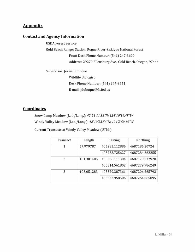
Coordinates
Snow Camp Meadow (Lat. /Long.): 42˚21’11.38”N; 124˚10’19.48”W
Windy Valley Meadow (Lat. /Long.): 42˚19’53.56”N; 124˚8’59.19”W
Current Transects at Windy Valley Meadow (UTMs)
Transect Length Easting Northing
1 57.979787 405285.112886 4687186.20724
405253.725627 4687284.362255
2 101.301405 405306.111304 4687179.037928
405314.561802 4687279.986249
3 103.051283 405329.387361 4687206.265792
405333.958506 4687264.065095

L. Miller - 35
Data: Bald Eagle, Mardon Skipper, Web Soil Survey
Bald Eagle Surveying Efforts
Citation: USDA Forest Service. 2013. Bald Eagle Monitoring Report for the Siskiyou Portion
of the Rogue River - Siskiyou National Forest. Manuscript in preparation. On file
with: J. Dubuque, Gold Beach Ranger District, 29279 Ellensburg Ave., Gold Beach,
Oregon, 97444
Rogue River Observation Summary 2013 Nest Site Location
Observation Location Number of Times
Surveyed Success?
Libby Creek FSRD 3300; Across Rogue River from Tu Tu’ Tun Lodge
5 times between April 16 and July
23
2 young fledged
Quosatana Campground
Quosatana Campground boat ramp; immediately opposite nest tree
6 times between April 16 and July
23
1 young fledged
Copper Canyon Turnout on FSRD 3300; with a Port-Orford Cedar
6 times between April 16 and July
23
2 young fledged
Watson Creek Off of Lower Rogue River Trail; Ernie’s boat-tie up at the end of road.
5 times between April 16 and July
23 Undetermined
Survey Year
Number of Young that
Fledged 1982 1983 1 1984 3 1985 2 1986 0 1987 3 1988 4 1989 2 1990 3
1991 3 1992 3 1993 3 1994 2 1995 2 1996 2 1997 2 1998 2 1999 1 2000 0 2001 0 2002 2
2003 2 2004 2 2005 1 2006 3 2007 6 2008 5 2009 5 2010 7 2011 1 2012 1 2013 5 Total 78
L. Miller - 36
Mardon Skipper Surveys
Citation: USDA Forest Service. 2013. Mardon Skipper 2013 Monitoring Report for the
Siskiyou Portion of the Rogue River - Siskiyou National Forest. Manuscript in
preparation. On file with: J. Dubuque, Gold Beach Ranger District, 29279 Ellensburg
Ave., Gold Beach, Oregon, 97444
2013 Windy Valley Meadow (Mdw # 629; T. 37 S., R. 1 W., Sec. 31, SE ¼, W.M) Date Observer(s) Species
Count Weather Conditions
Notes
13 June 2013
Holly Witt & Jessie Dubuque
226 fresh individuals
Temperature was round 78 degrees, sunny, clear and light intermittent breeze.
Used transect survey method. Occasional cloud cover would cause the Mardon to settle, but once cleared they would become active again. Nectar on camas lilies and a variety of small buttercups. Most numerous count thus far.
18 June 2013
Cameron Adams & Lily Miller
0 Rainy Showers; around 40 degrees F
Attempted to put in permanent transects using information provided by monitoring protocol set in document mentioned below. Was unsuccessful due to GPS projections on units were off. Did meadow restoration.
20 June 2013
Cameron Adams & Lily Miller
Observed while setting transects; 25 skippers, 7 Checkerspots, 2 Fritillary
Partly sunny; Temperature around 50 degrees F; Meadow was cold with sunny spots
Successful installation of permanent transects. Adjustments were made to include majority of suitable habitat and to move transects out of the trees. Map of transects can be seen in appendix along with transect UTM units.
3 July 2013
Cameron Adams & Lily Miller
Total: skippers 41; Fritilary 13; Checkerspot 4; Silvery Blue 1; Admiral 1
Sunny; about 75-80 degrees F
Distance surveying on transects was the surveying method used. Species count was taken for each transect and used to get total. The meadow was cooler in temperature than at the vehicle parked at trailhead.
2013 Snow Camp Meadow (Mdw # 626; T. 37 S., R. 1 W., Sec. 24 & 25, E ½, W.M) Date Observer(s) Species
Count Weather Conditions
Notes
15 July 2013
Cameron Adams
0 Temperature around 10 degrees; Sunny, clear, and no wind
Attempted to locate the Mardon skipper species in the area of the meadow. No skippers were detected
17 July 2013
Cameron Adams & Lily Miller
0 Temperature around 80 degrees, Sunny, clear, and no wind
No skippers were detected.
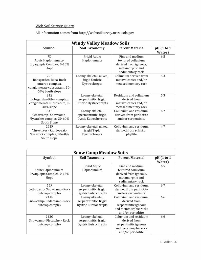
L. Miller - 37
Web Soil Survey Query
All information comes from http://websoilsurvey.nrcs.usda.gov
Windy Valley Meadow Soils Symbol Soil Taxonomy Parent Material pH (1 to 1
Water) 7D
Aquic Haplohumults-Cryaquepts Complex, 0-15%
Slope
Frigid Aquic Haplohumults
Fine and medium textured colluvium
derived from igneous, metamorphic and sedimentary rock
6.5
29F Bobsgarden-Rilea-Rock
outcrop complex, conglomerate cubstratum, 30-
60% South Slope
Loamy-skeletal, mixed, frigid Umbric Dystrochrepts
Colluvium derived from metavolcanics and/or metasedimentary rock
5.3
34E Bobsgarden-Rilea complex,
conglomerate substratum, 0-30% slope
Loamy-skeletal, serpentinitic, frigid
Umbric Dystrochrepts
Residuum and colluvium derived from
metavolcanics and/or metasedimentary rock
5.3
54F Cedarcamp- Snowcamp-
Flycatcher complex, 30-60% South Slope
Loamy-skeletal, spermentintic, frigid Dystic Eutrocherepts
Colluvium and residuum derived from peridotite
and/or serpentinite
6.7
262F Threetrees- Saddlepeak-
Scalerock complex, 30-60% South slope
Loamy-skeletal, mixed, frigid Typic
Dystrochrepts
Colluvium and residuum derived from schist or
phyllite
4.7
Snow Camp Meadow Soils Symbol Soil Taxonomy Parent Material pH (1 to 1
Water) 7D
Aquic Haplohumults-Cryaquepts Complex, 0-15%
Slope
Frigid Aquic Haplohumults
Fine and medium textured colluvium
derived from igneous, metamorphic and sedimentary rock
6.5
56F Cedarcamp- Snowcamp- Rock
outcrop complex
Loamy-skeletal, serpentinitic, frigid
Dystric Eutrochrepts
Colluvium and residuum derived from peridotite
and/or serpentinite
6.7
241E Snowcamp- Cedarcamp- Rock
outcrop complex
Loamy-skeletal, serpentitinitic, frigid
Dystric Eurtrochrepts
Colluvium and residuum derived from
serpentinitic igneous and metamorphic rocks
and/or periodtite
6.6
242G Snowcamp- Flycatcher- Rock
outcrop complex
Loamy-skeletal, serpentinitic, frigid
Dystric Eutrochrepts
Coluvium and residuum derived from
serpentinitic igneous and metamorphic rock
and/or peridotite
6.6
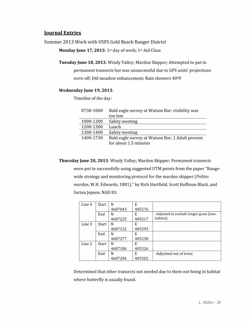
L. Miller - 38
Journal Entries
Summer 2013 Work with USFS Gold Beach Ranger District
Monday June 17, 2013: 1st day of work; 1st Aid Class
Tuesday June 18, 2013: Windy Valley; Mardon Skipper; Attempted to put in
permanent transects but was unsuccessful due to GPS units’ projections
were off; Did meadow enhancement; Rain showers 40ºF
Wednesday June 19, 2013:
Timeline of the day:
0730-1000 Bald eagle survey at Watson Bar; visibility was too low
1000-1200 Safety meeting 1200-1300 Lunch 1300-1400 Safety meeting 1400-1730 Bald eagle survey at Watson Bar; 1 Adult present
for about 1.5 minutes
Thursday June 20, 2013: Windy Valley; Mardon Skipper; Permanent transects
were put in successfully using suggested UTM points from the paper “Range-
wide strategy and monitoring protocol for the mardon skipper (Polites
mardon, W.H. Edwards, 1881).” by Rich Hartfield, Scott Hoffman Black, and
Sarina Jepsen. NAD 83.
Line 4 Start N 4687043
E 405276
End N 4687225
E 405217
-Adjusted to exclude longer grass (non-habitat)
Line 3 Start N 4687122
E 405293
End N 4687277
E 405238
Line 2 Start N 4687186
E 405326
End N 4687284
E 405302
-Adjusted out of trees
Determined that other transects not needed due to them not being in habitat
where butterfly is usually found.

L. Miller - 39
While walking setting up transects counted ~25 Mardon skippers, 7
Checkerspots, 2 Fliterary
Meadow was cold with patchy sun in habitat. When sun hit habitat
butterflies moved.
Friday June 21, 2013: Introduction to assignment for gathering the 1940’s aerial
photos; Assignment was to clean, organize, and find missing photos
Monday June 24, 2013: Off
Tuesday June 25, 2013: Off
Wednesday June 26, 2013: Off
Thursday June 27, 2013: Off
Monday July 1, 2013: Off
Tuesday July 2, 2013: Off
Wednesday July 3, 2013: Mardon skipper survey at Windy Valley; temperate was
cooler at meadow than at the truck
Survey started at 1050
Transect 3 (Start to End): Fritillary 6; Checkerspot 3; Silvery Blue 1;
Mardon Skipper 12
Transect 2 (End to Start): Mardon Skipper 26; Fritillary 2;
Checkerspot 1; Silvery Blue 2; Admiral 1
Transect 4 (Start to End): Mardon Skipper 3; Fritillary 5
Thursday July 4, 2013: Independence Day; Holiday; Off
Monday July 8, 2013: 1940’s aerial photos
Tuesday July 9, 2013: Invasive weed pull
Wednesday July 10, 2013: Invasive weed pull
Thursday July 11, 2013: 1940’s aerial photos
Monday July 15, 2013: 1940’s aerial photos
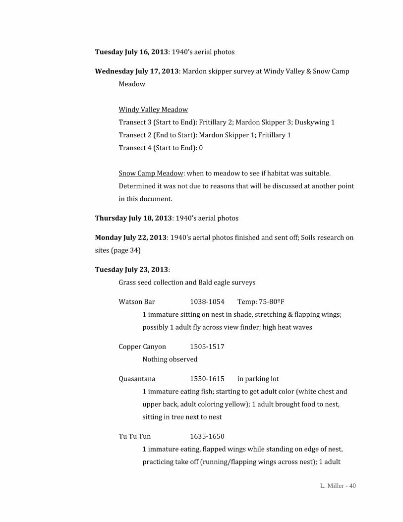
L. Miller - 40
Tuesday July 16, 2013: 1940’s aerial photos
Wednesday July 17, 2013: Mardon skipper survey at Windy Valley & Snow Camp
Meadow
Windy Valley Meadow
Transect 3 (Start to End): Fritillary 2; Mardon Skipper 3; Duskywing 1
Transect 2 (End to Start): Mardon Skipper 1; Fritillary 1
Transect 4 (Start to End): 0
Snow Camp Meadow: when to meadow to see if habitat was suitable.
Determined it was not due to reasons that will be discussed at another point
in this document.
Thursday July 18, 2013: 1940’s aerial photos
Monday July 22, 2013: 1940’s aerial photos finished and sent off; Soils research on
sites (page 34)
Tuesday July 23, 2013:
Grass seed collection and Bald eagle surveys
Watson Bar 1038-1054 Temp: 75-80ºF
1 immature sitting on nest in shade, stretching & flapping wings;
possibly 1 adult fly across view finder; high heat waves
Copper Canyon 1505-1517
Nothing observed
Quasantana 1550-1615 in parking lot
1 immature eating fish; starting to get adult color (white chest and
upper back, adult coloring yellow); 1 adult brought food to nest,
sitting in tree next to nest
Tu Tu Tun 1635-1650
1 immature eating, flapped wings while standing on edge of nest,
practicing take off (running/flapping wings across nest); 1 adult

L. Miller - 41
sitting in tree next to nest; Immature moved to where adult was
sitting.
Wednesday July 24, 2013: Grass seed collection
Thursday July 25, 2013: Worked at the Count Fair Forest Service booth from 1430-
1900
Monday July 29, 2013: Grass seed collection
Tuesday July 30, 2013: Grass seed collection
Wednesday July 31, 2013: Office
Thursday August 1, 2013: Invasive weed pulling with Botany
Monday August 5, 2013: Office
Tuesday August 6, 2013: Office
Wednesday August 7, 2013: Worked night shift starting 2000 doing owl surveys
Thursday August 8, 2013: Got off work at 0600 from the night shift
Friday August 9, 2013: Office and started aerial photo room. Organizing the photos
and cleaning the room where they are located.
Monday August 12, 2013: 1940’s aerial photos
Tuesday August 13, 2013: Grass seed collection
Wednesday August 14, 2013: Grass seed collection
Thursday August 15, 2013: Grass seed collection
Monday August 19, 2013: Annual Leave; Off
Tuesday August 20, 2013: Grass seed collection
Wednesday August 21, 2013: Grass seed collection
Thursday August 22, 2013: Grass seed collection

L. Miller - 42
Monday August 26, 2013: Grass seed collection
Tuesday August 27, 2013: Grass seed collection
Wednesday August 28, 2013: Office day; Worked on aerial photo room
Thursday August 29, 2013: Grass seed collection
Friday August 30, 2013: Worked on aerial photo room for credit hours from 0800-
1000
Monday September 2, 2013: Labor Day; Holiday; Day off
Tuesday September 3, 2013: Went with wildlife crew (2 other people) and
supervisor to Ludlum House and campground to look at determine where to
put bat boxes on the house. Pictures are at the following location. Also
looked at the orchard and determined that the meadow enhancement
needed to be performed.
Wednesday September 4, 2013: Worked at Ludlum House orchard
Thursday September 5, 2013: Worked at Ludlum House orchard
Friday September 6, 2013: Worked on aerial photo room for credit hours from
0800-1330
Monday September 9, 2013: Office day; Worked on aerial photo room
Tuesday September 10, 2013: Office day; Worked on aerial photo room
Wednesday September 11, 2013: Worked at Ludlum House orchard
Thursday September 12, 2013: Worked at Ludlum House orchard
Friday September 13, 2013: Worked on aerial photo room
Monday September 16, 2013: Assisted in the preparation of the site for the
Experience the Elk event taking place that weekend on the Elk River near
Port Orford
Tuesday September 17, 2013: Worked on aerial photo room

L. Miller - 43
Wednesday September 18, 2013: Worked at Ludlum House orchard
Thursday September 19, 2013: Last day of work; Worked from 1000-1200 getting
information together that I may need for my capstone
List of Tasks and Projects
Daily Journal Entries:
o A rough record of the day’s findings, work done, etc.
Mardon Skipper Surveying:
o Surveys of known habitat
o Determine essential aspects of habitat
o Completed permanent transects for Windy Valley survey site using
suggested coordinates from “Range-wide strategy and monitoring protocol
for the mardon skipper (Polites mardon, W.H. Edward, 1881)” by Richard
Hatfield, Scott Hoffman Black, and Sarina Jepsen.
o Created a soil profile using USGS Soil Mapping site (results page 37 with
aerial photos on page 25)
o Visited Windy Valley site with Rich Hatfield and Candace Fallon and reset
transects. Also learned proper technique for distance sample surveying and
monitoring described in “Mardon Skipper (Polites mardon, W. H. Edwards,
1881) Rangewide Monitoring Protocol” by Rich Hatfield.
1940’s Aerial Photo Organization
Started Index of All Aerial Photos
Native grass collection
o Danthonia californica (California oatgrass)
Invasive plant species control
o French Broom
Meadow restoration and enhancement
o Ludlum Orchard
o Windy Valley Meadow

L. Miller - 44
Mardon Skipper Surveying Datasheet
Temp __________
(Deg. F)
Transect Number MASK Distance Behavior (F/S)
(mph or Beaufort scale)Start Time ___________ End Time ____________
Observer: __________________________
Comments/Notes
Mardon Skipper Distance Sampling DatasheetCloud Cover % ________
Wind Speed _____________
Date: __________Site Name: _____________________
L. Miller - 45
Acknowledgements
There are several people that have helped me get to where I am today.
First off I would like thank my parents. They have helped me realize that I can do so much. My
father has also pointed out several times that the Mardon skipper is an interesting and intriguing
species that has quite a bit to offer concerning research opportunities.
I would also like to thank Jessie Dubuque and the USDA Forest Service employees at the Gold Beach
Ranger Station. The opportunity for my internship would not have existed otherwise. I gained great
experience working in 2013 and this year, 2014, doing Mardon skipper surveying and other
projects.
Another group on my Thank You list is the Xerces Society, especially Rich Hatfield and Candace
Fallon. They helped reset the permanent transects and took time to teach Jessie Dubuque and I the
proper way to do distance monitoring. Having a field day to Windy Valley with them was eye
opening.
Lastly I would like to thank my professor and academic advisor, Mark Van Steeter. If I had never
taken that Intro to Physical Geography class that he taught, who knows where I would be today. His
enthusiasm about the world around him is something that I wish more people had, and it has
inspired me to look at the world as exiting experience.