mapping shallow geology and gas hydrate with marine csem surveys
TRANSCRIPT
© 2010 EAGE www.firstbreak.org 97
special topicfirst break volume 28, June 2010
A New Spring for Geoscience
Canyon 118 (MC 118), and Alaminos Canyon 818 (AC 818). These represent geologically distinct areas within the GoM in water depths that varied from 900 to 3000 m, and two of the survey locations (AC 818 and GC 955) were GoM Gas Hydrates Joint Industry Program (JIP) proposed drilling sites. We obtained ship time on the research vessel Roger Revelle for October 2008. A month before the cruise we added a fourth site, Walker Ridge 313 (WR 313). This prospect had been added to the JIP drilling program, and we wanted to use the JIP results to provide ground truth for the marine CSEM surveys. Both WR 313 and GC 955 were drilled by the JIP in the spring of 2009 and both successfully sampled gas hydrate (see Boswell et al., 2010). Figure 1 shows the locations of the four surveys.
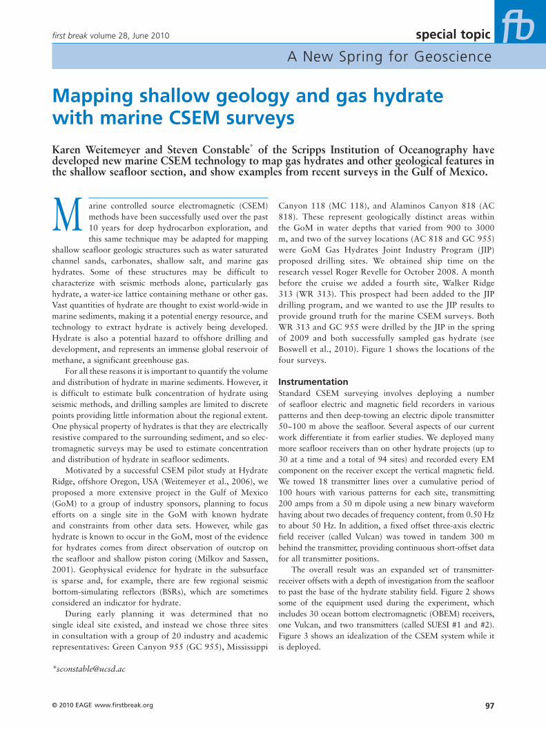
InstrumentationStandard CSEM surveying involves deploying a number of seafloor electric and magnetic field recorders in various patterns and then deep-towing an electric dipole transmitter 50−100 m above the seafloor. Several aspects of our current work differentiate it from earlier studies. We deployed many more seafloor receivers than on other hydrate projects (up to 30 at a time and a total of 94 sites) and recorded every EM component on the receiver except the vertical magnetic field. We towed 18 transmitter lines over a cumulative period of 100 hours with various patterns for each site, transmitting 200 amps from a 50 m dipole using a new binary waveform having about two decades of frequency content, from 0.50 Hz to about 50 Hz. In addition, a fixed offset three-axis electric field receiver (called Vulcan) was towed in tandem 300 m behind the transmitter, providing continuous short-offset data for all transmitter positions.
The overall result was an expanded set of transmitter-receiver offsets with a depth of investigation from the seafloor to past the base of the hydrate stability field. Figure 2 shows some of the equipment used during the experiment, which includes 30 ocean bottom electromagnetic (OBEM) receivers, one Vulcan, and two transmitters (called SUESI #1 and #2). Figure 3 shows an idealization of the CSEM system while it is deployed.
M arine controlled source electromagnetic (CSEM) methods have been successfully used over the past 10 years for deep hydrocarbon exploration, and this same technique may be adapted for mapping
shallow seafloor geologic structures such as water saturated channel sands, carbonates, shallow salt, and marine gas hydrates. Some of these structures may be difficult to characterize with seismic methods alone, particularly gas hydrate, a water-ice lattice containing methane or other gas. Vast quantities of hydrate are thought to exist world-wide in marine sediments, making it a potential energy resource, and technology to extract hydrate is actively being developed. Hydrate is also a potential hazard to offshore drilling and development, and represents an immense global reservoir of methane, a significant greenhouse gas.
For all these reasons it is important to quantify the volume and distribution of hydrate in marine sediments. However, it is difficult to estimate bulk concentration of hydrate using seismic methods, and drilling samples are limited to discrete points providing little information about the regional extent. One physical property of hydrates is that they are electrically resistive compared to the surrounding sediment, and so elec-tromagnetic surveys may be used to estimate concentration and distribution of hydrate in seafloor sediments.
Motivated by a successful CSEM pilot study at Hydrate Ridge, offshore Oregon, USA (Weitemeyer et al., 2006), we proposed a more extensive project in the Gulf of Mexico (GoM) to a group of industry sponsors, planning to focus efforts on a single site in the GoM with known hydrate and constraints from other data sets. However, while gas hydrate is known to occur in the GoM, most of the evidence for hydrates comes from direct observation of outcrop on the seafloor and shallow piston coring (Milkov and Sassen, 2001). Geophysical evidence for hydrate in the subsurface is sparse and, for example, there are few regional seismic bottom-simulating reflectors (BSRs), which are sometimes considered an indicator for hydrate.
During early planning it was determined that no single ideal site existed, and instead we chose three sites in consultation with a group of 20 industry and academic representatives: Green Canyon 955 (GC 955), Mississippi
Mapping shallow geology and gas hydrate with marine CSEM surveys
Karen Weitemeyer and Steven Constable* of the Scripps Institution of Oceanography have developed new marine CSEM technology to map gas hydrates and other geological features in the shallow seafloor section, and show examples from recent surveys in the Gulf of Mexico.

www.firstbreak.org © 2010 EAGE98
special topic first break volume 28, June 2010
A New Spring for Geoscience
similar approach was taken with the Vulcan data except that the Vulcan apparent resistivity pseudo-sections were generated using the total field from all three components of the electric field measured by the instrument. Forward modelling was again used to compute apparent resistivities as a function of frequency. The apparent resistivities were projected into depth using skin depths for each frequency as a length scale, as shown in Figure 3 (right).
Pseudo-sections provide a way to observe lateral varia-tions in resistivity and give qualitative depth relationships. However, they do not provide quantitative depth informa-tion, and so the depth scales in the following figures should not be taken literally. Results for the GC 955 and MC 118 surveys are discussed below.
Green Canyon 955 (GC 955)GC 955 is a prospect in intermediate water depth (1900−2200 m) located seaward of the Sigsbee Escarpment, with evidence of surface features often associated with hydrate, such as mud volcanoes. It is at the mouth of Green Canyon, which brings sediment onto the deep seafloor, and there is a channel in the bathymetry as well as channel sands at depth. The JIP drilling target was one such channel sand, well defined in seismic data and showing evidence of gas accumulation near the base of the hydrate stability field (McConnell et al., 2010; Hutchinson et al., 2008).
Drilling operations were being conducted on the block at well #02 during our CSEM survey, and in order to avoid the anchor pattern of the rig our 20 OBEM receivers and two CSEM tow lines had to be moved from some of the proposed JIP drill locations (Figure 4). The N-S CSEM line
Data processing and pseudo‑section analysisData from the seafloor instruments were processed by using a FFT to convert from time domain to frequency domain, stacked over 60 second windows, and merged with transmit-ter navigational parameters. The transmitter and receiver geometry for each stack frame was then used to generate 1D half-space forward models for various resistivities using the Dipole1D code of Key (2009). The major axis of the polarization ellipse was used to select the half-space forward model that matched the recorded data, to create an appar-ent resistivity for each transmitter-receiver pair. Finally, a pseudo-section projection technique was used to image the data. Figure 3 (left) shows a schematic of the data projection for mapping ranges into depths the longer the transmitter-receiver offset the deeper that data point is projected. A
Figure 1 Four areas in the Gulf of Mexico were surveyed with marine CSEM using the Roger Revelle from 7−26 October 2008: Alaminos Canyon 818 (AC 818), Walker Ridge 313 (WR 313), Green Canyon 955 (GC 955), and Mississippi Canyon 118 (MC 118) (bathymetry from the NGDC).
Figure 2 Back deck of the Roger Revelle during transit to the final survey area. The various pieces of equipment used for the experiment are labelled.

© 2010 EAGE www.�rstbreak.org 99
special topic�rst break volume 28, June 2010
A New Spring for Geoscience
is located in an area of four-way closure consisting of a bathymetric high cored by allochthonous salt, above which levee sands are sealed by a regional shale layer. Faults here provide migration pathways for fluids (Hutchinson et al., 2008). This allochthonous salt is a large regional feature that is hour-glass shaped and extends to the south into Walker Ridge (McConnell et al., 2010). The seismic signature of the
channel sand expected to contain gas hydrate is shaded grey in the figure, and the E-W CSEM line will cross any exten-sion of this to the south. A horseshoe shaped scarp face also exists to the east, which likely resulted from internal failure due to fluid flow and gravitational forces at over-pressured sand outcropping at the base of the Sigsbee escarpment. A similar process is likely occurring below the E-W CSEM line
Figure 3 Marine CSEM system showing deployed OBEM instruments and the towed 3-axis electric field receiver called Vulcan. We can build apparent resistivity pseudo-sections two different ways: The left side shows apparent resistivities derived from OBEM instruments projected to a mid-point between the EM transmit ter and receiver, at a pseudo-depth proportional to the transmitter-receiver offset. For the fixed-offset towed receiver (right), apparent resistivities from different frequencies can be projected at the common mid-point based on skin depth, with lower frequencies having larger skin depths/deeper penetration.
Figure 4 GC 955 survey map with annotations from Hutchinson et al. (2008) (left) and OBEM pseudo-sections for 0.5 Hz (right).

www.�rstbreak.org © 2010 EAGE100
special topic �rst break volume 28, June 2010
A New Spring for Geoscience
‘I’, drilled into the axis of the channel, but water saturated sand with very little hydrate or free gas was encountered instead (McConnell et al., 2010).
Mississippi Canyon 118 (MC 118)MC 118 is on the continental slope in relatively shallow water (800–900 m), which complements the other three sites surveyed. It is east of Mississippi Canyon and is a Minerals Management Service (MMS) designated hydrate observa-tory. A 1 km square mound in the south-central portion of the observatory contains three crater complexes and is associated with large outcrops of hydrate and fluid flux through the seafloor, but there is as yet no direct evidence of hydrate at depth.
This area provides an opportunity to coordinate and collaborate with many other ongoing scientific programmes, including shallow resistivity surveying. We deployed 24 OBEM receivers in a 6 x 4 array approximately 500 m apart (avoiding the already installed seafloor equipment) and towed 10 transmitter lines in a grid pattern (Figure 6). Flying the transmitter at a height of 60 m allowed us to transmit over installed equipment and pipelines. Fluid vent-ing is associated with fracturing in the vicinity of the mound: these fractures originate from the salt diapir, estimated to be greater than 300 m deep, and carry methane gas to the sea-floor (Lutken, et al., 2006; McGee et al., 2008). Sediments are fine-grained hemipelagic mud with minor foraminiferal sand and contain a complex chemosynthetic community (bio-encrusted) around the craters, resulting in authigenic carbonates (Lutken, et al., 2006; McGee et al., 2008). The three crater complexes are designated as SE, SW, and NW complexes (McGee et al., 2008). The SE complex has low relief and no observable venting, but a pavement of meth-anotropic clam shells provides evidence for past activity. The SW complex is in a region of moderate to high relief and has moderate to high venting. The NW complex has moderate to low relief with moderate to low levels of venting.
Vulcan pseudo-sections (Figure 7) indicate MC 118 is rather conductive, with a background resistivity of 0.5−1 Ωm, and is generally featureless except at the SE crater complex. No constraints were placed on the intersecting tow lines and so the fact that three lines independently give a resistive body at the SE complex suggests that this is an attribute of the geology rather than a data artifact. The E-W tow line that crosses through the SE and SW complex has been overlaid on acoustic chirp line 119 from Sleeper et al. (2006) in the figure to compare acoustic blanking zones to electrical conductivity. The acoustic blanking or wipe-out zones at MC 118 are attributed to authigenic carbonate and free gas/gas hydrate (Lapham et al. 2008; McGee et al., 2008). The pavement of dead clams at the SE complex suggests that the conduit which once supplied methane to these clams became blocked, perhaps due to hydrate forma-
to the east of the area of four-way closure, where there is an amphitheater-shaped region of seep sapping (McConnell et al., 2010).
Pseudo-sections for the OBEM data at the fundamental frequency of 0.5 Hz are shown in Figure 4 (right). One main observation is that the deeper parts of the N-S CSEM line are more resistive than the E-W CSEM line, likely caused by the allochthonous salt body present along the N-S line. The E-W line is perpendicular to this structure and is less affected by the presence of salt. Gas hydrates were found in GC 955 well ‘H’ and ‘Q’, both targeting hydrate filled sands located in the area of four-way closure (McConnell et al., 2010). The drilling at well ‘Q’ had to be aborted due to gas flow, either caused by hydrate dissociation or free gas (McConnell et al., 2010). The shallow part of N-S pseudo-section is resistive at site s05, consistent with the existence of hydrate in the coincident JIP well ‘Q’.
Figure 5 shows E-W line pseudo-sections for Vulcan and two frequencies of OBEM data. The three images tell a con-sistent story: a conductive region to the east (s16 to s20) and more resistive area on the bathymetric slope (s15, s09, s14), grading into a interspersed conductive and resistive region at the bathymetric high (s11-s13). The resistive region below s11 in the OBEM data is observed in the Vulcan data as well, but is offset due to the different projection geometries of Vulcan and OBEM apparent resistivities. JIP well ‘H’, located on the flank of the area of four-way closure, is about 1 km north and is roughly between s09 and s15. Drilling at ‘H’ found a shale section with fracture-filled hydrate and a deeper occurrence of alternating gas hydrate and water bearing intervals within a single sand reservoir (McConnell et al., 2010), consistent with the resistive region between s15 and s14.
The eastern conductive region between s16 and s20 is likely the southern extension of the porous channel sand targeted by the JIP. Hydrate was expected to be found in well
Figure 5 GC 955 EW CSEM line for the Vulcan data (top), 6.5 Hz OBEM data (middle), and 0.5 Hz OBEM data (bottom). Black dots are the data projections used to generate the pseudo-sections.

© 2010 EAGE www.�rstbreak.org 101
special topic�rst break volume 28, June 2010
A New Spring for Geoscience
The OBEM pseudo-sections at 6.5 Hz are shown in Figure 8 and give results consistent with the Vulcan pseudo-sections. Three CSEM tow lines independently show a resistor at the SE complex in a background resistivity of about 1 Ωm. The OBEM data are sensitive to the top few kilometers of sediment while the Vulcan data sense the top few hundreds of meters. Seafloor background resistivies are thus slightly elevated in the OBEM data since they are sam-pling a larger and deeper sediment volume. Inconsistencies in the OBEM pseudo-sections at the crossing points of N-S and E-W CSEM tow lines at site 9 are likely caused by navigational errors, although they could be due to a deep resistor.
tion (McGee et al., 2008). We find that the SE complex resistor appears to have some depth extent and is coincident with the acoustic blanking there, suggesting that hydrate is indeed present in the section. On the other hand, the acoustic blanking towards the SW complex is attributed to shallow carbonates (Macelloni, pers comm.), but is not associated with resistive seafloor. This is significant in that hydrate and carbonates, thought to be confounding electrical resistors, appear to be differentiable in this case.
Figure 7 Frequency depth sections from Vulcan at MC 118 (top) and anE-W transect from Line 5 (crossing the SE crater complex) overlain on chirp acous tic data from Sleeper et al. (2006) to show the correlation of resistivity with acoustic blanking (bottom).
Figure 6 Survey map of Mississippi Canyon 118 with detail of the three crater complexes (bathymetry was provided by Leonardo Macelloni and the close up of the three crater complexes is from Sleeper et al., 2006).
Figure 8 Mississippi Canyon 118 OBEM apparent resistivity pseudo-sections at 6.5 Hz.

www.firstbreak.org © 2010 EAGE102
special topic first break volume 28, June 2010
A New Spring for Geoscience
Proceedings of the 6th International Conference on Gas Hydrates
(ICGH 2008), Vancouver, BC, Canada.ICGH_5506_1_41330.
Key, K. [2009] 1D inversion of multicomponent, multifrequency marine
CSEM data: Methodology and synthetic studies for resolving thin
resistive layers. Geophysics, 74(2) F9-F20.
Lapham, L.L., Chanton, J.P., Martens, C.S., Sleeper, K. and Woolsey,
J.R. [2008] Mircobial activity in surficial sediments overly-
ing acoustic wipeout zones at a Gulf of Mexico cold seep.
Geochemistry, Geophysics, and Geosystems, 9(6), Q06001,
doi:10.1029/2008GC001944.
Lutken, C.B., Brunner, C.A., Lapham, L., Chanton, J., Rogers, R.,
Sassen, R., Dearman J., Lynch, L., Kuykendall, J. and Lowrie A.
[2006] Analyses of Core Samples From Mississippi Canyon 118.
Offshore Technology Conference, OTC-18208.
McConnell, D., Boswell, R., Collett, T., Frye, M., Shedd, W., Guerin,
G., Cook, A., Mrozewski, S., Dufrene, R. and Godfriaux, P. [2010]
Gulf of Mexico Gas Hydrate Industry Project Leg II: Green Canyon
955 Site Summary. http://www.netl.doe.gov/technologies/oil-gas/
FutureSupply/MethaneHydrates/JIPLegII-IR/.
McGee, T., Woolsey, J.R.,Lapham, L., Kleinberg, R.,Macelloni, L.,
Battista, B., Knapp, C, Caruso, S., Goebel, V., Chapman, R. and
Gerstoft, P. [2008] Structure of a carbonate/hydrate mound in
the northern Gulf of Mexico. Proceedings of the 6th International
Conference on Gas Hydrates (ICGH 2008), Vancouver, BC,
Canada. ICGH_5477_40920.
Milkov, A. and Sassen, R. [2001] Estimates of gas hydrate resource
northwestern Gulf of Mexico continental slop. Marine Geology.
179, 71-83.
Sleeper, K., Lowrie, A., Bosman, A., Macelloni, L. and Swann, C.T.
[2006] Bathymetric mapping and high resolution seismic profil-
ing by AUV in MC 118 (Gulf of Mexico). Offshore Technology
Conference. OTC-18133. Data made available at: http://www.
olemiss.edu/depts/mmri/programs/mc118/pro_-map.html.
Weitemeyer, K.A., Constable, S.C., Key, K.W. and Behrens, J.P. [2006]
First results from a marine controlled source electromagnetic sur-
vey to detect gas hydrates offshore Oregon. Geophysical Research
Letters, 33, L03304, doi:10.1029/2005GL024896.
ConclusionsWe have presented initial results from an extensive campaign dedicated to imaging gas hydrates using marine CSEM in the Gulf of Mexico. Apparent resistivity pseudo-sections from two types of data sets, deployed seafloor instruments and a new towed instrument called Vulcan, are consistent but have complimentary sensitivities. Vulcan provides continuous data coverage sensitive to a few hundred metres deep, and the OBEMs provide data sensitive to deeper seafloor structure. Correlation of resistivity images with known and inferred geology is good, suggesting that this new method is potentially a powerful tool for mapping offshore geology in the shallow part of the section.
AcknowledgementsWe thank our industrial sponsors ExxonMobil, WesternGeco, Chevron, EMGS, Fugro, CGG/Veritas, Shell, and Statoil, as well as the MMS and NETL programme of the US Department of Energy (contract DE-NT0005668). Ship time was provided by the University of California Shipfunds Committee. Many thanks to the captain and crew of the Roger Revelle and SIO Marine EM Laboratory personnel. We thank Bob Hardage, and numerous col-leagues in the JIP and Gulf of Mexico Hydrates Research Consortia for advice and support over the years this project took to mature.
References:Boswell, R., Collett, T., Frye, M., McConnell, D., Shedd, W., Mrozewski,
S., Guerin, G. and Cook, A. [2010] Gulf of Mexico Gas Hydrate
Joint Industry Project Leg II: Technical Summary. http://www.
netl.doe.gov/technologies/oil-gas/FutureSupply/MethaneHydrates/
JIPLegII-IR/.
Hutchinson, D.R., Shelander, D., Dai, J., . McConnell, D., Shedd, W.,
Frye, M., Ruppel, C., Boswell, R., Jones, E., Collett, T., Rose, K.,
Dugan, B., Wood, W. and Latham, T. [2008] Site Selection for
DOE/JIP Gas Hydrate drilling in the northern Gulf of Mexico.
www.eage.org/bookshop
This book by Ian Jones sets-out to give the reader a non-mathematical understanding ofthe basic principles of migration and of building a velocity model of the earth’s subsurface.
Book available now!
An Introduction to: Velocity Model Building
EAGE-bookshop stopper EAGE-bookshop ad robein.indd 1 15-03-2010 17:18:57