map projection and coordinates - chiang mai university projection an… · 1 ags 722 (2-2003) map...
TRANSCRIPT

1
AGS 722 (2-2003)
Map Projection and Coordinates
The shape of the earthModels
Sphere with radius of ~6378 km Ellipsoid (or Spheroid) with equatorial radius (semi-major axis) of ~6378 km and polar radius (semi-minor axis) of ~6357 km
AGS 722 (2-2003)
Difference of ~21 km usually expressed as “flattening” (f ) ratio of the ellipsoid: f = difference/major axis
= ~1/300 for earth
The Shape of the Earth

2
AGS 722 (2-2003)
a = Semimajor axis b = Semiminor axis X, Y, Z = Reference
frame
Spheroid is the result of rotating an ellipse around an axis
The Shape of the Earth
AGS 722 (2-2003)
Ellipsoid– The Earth revolves
easterly on its axis, generating centrifugal force, causing a bulge in the middle and flattening at the poles
Geoid – Representation of
the Earth as an equigravitationalsurface
Due to variations in gravity, the geoid does not follow the ellipsoid exactly (100 m deviation)
Geoid height –difference between ellipsoid and geoid(geoid undulation)
© Paul Bolstad, GIS Fundamentals
The Shape of the Earth

3
AGS 722 (2-2003)
The Shape of the Earth
Many attempts to measure the size and shape of the earth’s spheroid.An estimate of ellipsoid allows calculation of the elevation of every point on earth including the sea level.A base reference for the adjustment of geodetic measurements is called datum.
AGS 722 (2-2003)
Why different EllipsoidsBetter methods for approximating the surface of the EarthDeveloped from different areas of the EarthJust an approximation…
The Shape of the Earth

4
AGS 722 (2-2003)
We have to know datum and ellipsoid when using a GPS (Global Positioning System) receiver.In Thailand, a topographic map is based on Indian datum, and Everest Spheroid.
The Shape of the Earth
AGS 722 (2-2003)
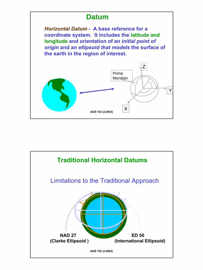
Datum
The ellipsoid is a mathematical model that describes the shape of the earth. A datum defines the position of the ellipsoid relative to the center of the earthProvides a frame of reference for measuring locations on the surface of the earthAligns its spheroid to closely fit the earth’s surface in a particular area
© ESRI, ARC/INFO Help
5
AGS 722 (2-2003)
Horizontal Datum - A base reference for a coordinate system. It includes the latitude and longitude and orientation of an initial point of origin and an ellipsoid that models the surface of the earth in the region of interest.
Datum
Y
Prime Meridian
X
Z
AGS 722 (2-2003)
Traditional Horizontal Datums
Limitations to the Traditional Approach
NAD 27(Clarke Ellipsoid )
ED 50(International Ellipsoid)
6
AGS 722 (2-2003)
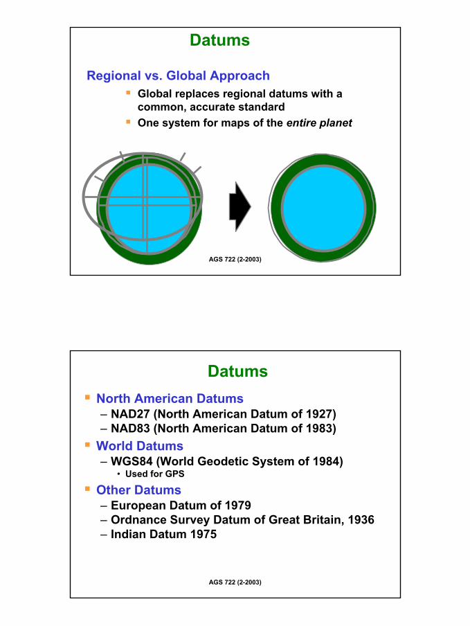
Datums
Global replaces regional datums with a common, accurate standardOne system for maps of the entire planet
Regional vs. Global Approach
AGS 722 (2-2003)
DatumsNorth American Datums– NAD27 (North American Datum of 1927)– NAD83 (North American Datum of 1983)
World Datums – WGS84 (World Geodetic System of 1984)
• Used for GPS
Other Datums– European Datum of 1979– Ordnance Survey Datum of Great Britain, 1936– Indian Datum 1975

7
AGS 722 (2-2003)
The Graticule
Graticule: the pattern of meridians and parallels on the earth based on– Equally spaced
parallels between the equator and the poles
– Parallels are always parallel to one another, so they are always the same distance apart
AGS 722 (2-2003)
Parallels and Meridians
Meridians are also known as lines of longitude– Example is the prime
meridianParallels are also known as lines of latitude– Example is the equator
© Paul Bolstad, GIS Fundamentals

8
AGS 722 (2-2003)
The Graticule– Meridians are spaced farthest apart on
the equator and converge to a single point at the poles
– Parallels and meridians cross one another at right (90o) angles
AGS 722 (2-2003)
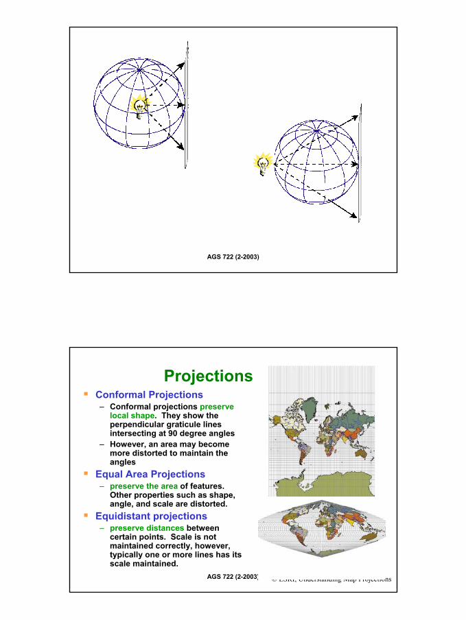
Concept of a Projection
A systematic rendering of a graticuleProjection Surfaces– Plane– Developable Surfaces
• Cone• Cylinder
Different projections create different distortions
© Paul Bolstad, GIS Fundamentals
© ESRI, ArcView Help
9
AGS 722 (2-2003)
AGS 722 (2-2003) © ESRI, Understanding Map Projections
ProjectionsConformal Projections – Conformal projections preserve
local shape. They show the perpendicular graticule lines intersecting at 90 degree angles
– However, an area may become more distorted to maintain the angles
Equal Area Projections – preserve the area of features.
Other properties such as shape, angle, and scale are distorted.
Equidistant projections– preserve distances between
certain points. Scale is not maintained correctly, however, typically one or more lines has its scale maintained.
10
AGS 722 (2-2003)
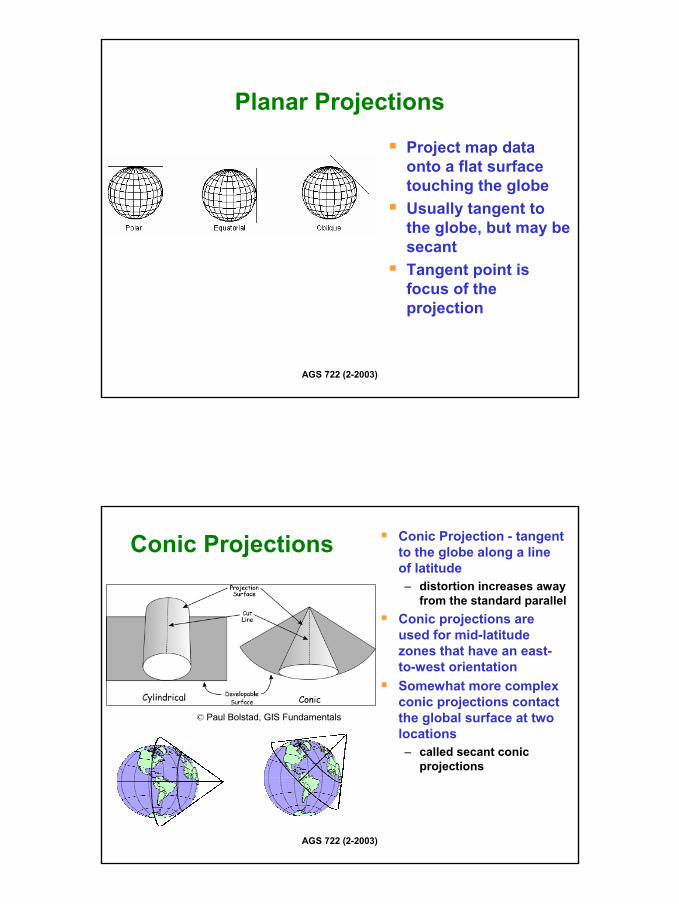
Planar Projections
Project map data onto a flat surface touching the globeUsually tangent to the globe, but may be secantTangent point is focus of the projection
AGS 722 (2-2003)
Conic Projections Conic Projection - tangent to the globe along a line of latitude– distortion increases away
from the standard parallelConic projections are used for mid-latitude zones that have an east-to-west orientationSomewhat more complex conic projections contact the global surface at two locations– called secant conic
projections
© Paul Bolstad, GIS Fundamentals
11
AGS 722 (2-2003)
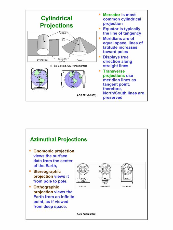
Cylindrical Projections
Mercator is most common cylindrical projectionEquator is typically the line of tangencyMeridians are of equal space, lines of latitude increases toward polesDisplays true direction along straight linesTransverse projections use meridian lines as tangent point, therefore, North/South lines are preserved
© Paul Bolstad, GIS Fundamentals
AGS 722 (2-2003)
Azimuthal Projections
Gnomonic projectionviews the surface data from the center of the Earth, Stereographic projection views it from pole to pole. Orthographic projection views the Earth from an infinite point, as if viewed from deep space.
12
AGS 722 (2-2003)
Major Properties of Projections
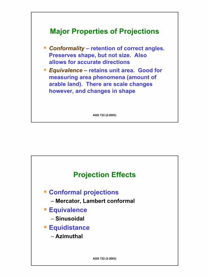
Conformality – retention of correct angles. Preserves shape, but not size. Also allows for accurate directionsEquivalence – retains unit area. Good for measuring area phenomena (amount of arable land). There are scale changes however, and changes in shape
AGS 722 (2-2003)
Projection Effects
Conformal projections– Mercator, Lambert conformal
Equivalence– Sinusoidal
Equidistance– Azimuthal

13
AGS 722 (2-2003)
Compromise Projections
Miller Cylindrical – similar to Mercator, but distorts size somewhat less– However, its not conformal, and lack the
directional integrityRobinson – minimizes visually disturbing distortions
AGS 722 (2-2003)
Different Projections
Mercator projection – conformality
Sinusoidal – equivalence
Millers Cylindrical – compromise
Robinson - compromise

14
AGS 722 (2-2003)
Basic Coordinate-System Concepts:
The fundamental spherical coordinate system used to locate positions on the earth’s surface.A way of representing the earth’s spherical shape as a flat surface.A smooth approximation of the earth’s irregular surface.
AGS 722 (2-2003)
What is a Coordinate System
A coordinate system defines the location of a point on a planar or spherical surfaceA geographic coordinate system is a three–dimensional reference system that locates points on the Earth’s surface. – The unit of measure is usually
decimal degrees. A point has two coordinate values: latitude and longitude.
– Latitude and longitude measure angles.

15
AGS 722 (2-2003)
Cartesian VS. Geographic Coordinate Systems
© Paul Bolstad, GIS Fundamentals
AGS 722 (2-2003)
Facts About Latitude
Lines of latitude (parallels)are evenly spaced (small circles) from 0o at equator (a great circle) to 90o at poles. 60 nautical miles (~ 110 km)/1o, ~1.8 km/minute and ~ 30 m/second of latitude. N. latitudes are positive (+φ)S. latitudes are negative (-φ).

16
AGS 722 (2-2003)
Longitude (λ)
Longitude is the angle (λ) between the plane of the prime meridian and the meridianalplane containing the point of interest (P).
AGS 722 (2-2003)
Facts About Longitude (λ)
Lines of longitude (meridians) converge at the poles.The distance of a degree of longitude varies with latitude. Zero longitude is the Prime (Greenwich) Meridian (PM); longitude is measured from 0-180o east and west of the PM. East longitudes are positive (+λ), west longitudes are negative (−λ).
17
AGS 722 (2-2003)
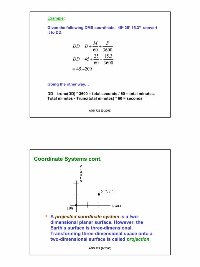
Example:
Given the following DMS coordinate, 45o 25’ 15.3” convert it to DD.
Going the other way…
DD – trunc(DD) * 3600 = total seconds / 60 = total minutes.Total minutes - Trunc(total minutes) * 60 = seconds
4209.453600
3.15602545
360060
=
++=
++=
DD
SMDDD
AGS 722 (2-2003)
Coordinate Systems cont.
A projected coordinate system is a two-dimensional planar surface. However, the Earth’s surface is three-dimensional. Transforming three-dimensional space onto a two-dimensional surface is called projection.
18
AGS 722 (2-2003)
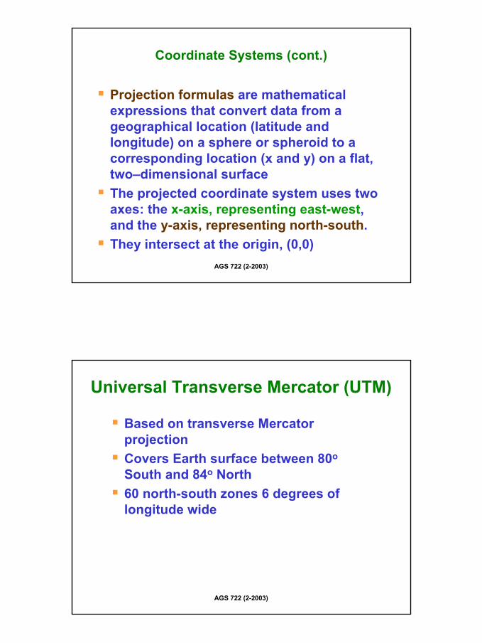
Projection formulas are mathematical expressions that convert data from a geographical location (latitude and longitude) on a sphere or spheroid to a corresponding location (x and y) on a flat, two–dimensional surfaceThe projected coordinate system uses two axes: the x-axis, representing east-west, and the y-axis, representing north-south.They intersect at the origin, (0,0)
Coordinate Systems (cont.)
AGS 722 (2-2003)
Universal Transverse Mercator (UTM)
Based on transverse MercatorprojectionCovers Earth surface between 80o
South and 84o North60 north-south zones 6 degrees of longitude wide

19
Universal Tranverse MercatorThe UTM graticule coverage
180o 180o0o
1 30 60
84o N
80o S
Equator
Each belt is 6O in longitude wide
0 meters10,000,000m
AGS 722 (2-2003)
Projections
UTM is an international metric coordinate system that covers the entire earth. It has the advantage of being mathematically consistent and well defined for the entire earth. Local coordinate systems are often used to fit mapping needs for a particular region.
20
AGS 722 (2-2003)
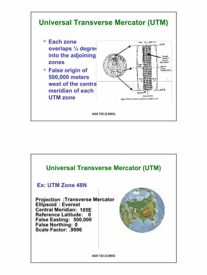
Each zone overlaps ½ degree into the adjoining zonesFalse origin of 500,000 meters west of the central meridian of each UTM zone
Universal Transverse Mercator (UTM)
AGS 722 (2-2003)
Projection :Transverse MercatorEllipsoid : EverestCentral Meridian: 105EReference Latitude: 0False Easting: 500,000False Northing: 0Scale Factor: .9996
Ex: UTM Zone 48N
Universal Transverse Mercator (UTM)
21
AGS 722 (2-2003)