map of windham county, vt 1856 - old maps
TRANSCRIPT

Map of Windham County, VT 1856 1
Map of Windham County, VT 1856
Edition of August, 2005© Old Maps PO Box 54 West Chesterfield, NH 03466
www.old-maps.com
A complete copy of the 1856 county map showing the names and locations of 1000s of houses, businesses, churches and schools as they were a century and a half ago. This old map was the first comprehensive road map of the seventeen towns of Windham County. This CDROM reproduction marks the second time the 1856 map has been reproduced. The earlier 1981 Atlas Edition, also published by Old Maps, is now out of print.
To find your town, click on the name in the list below
ATHENS BRATTLEBORO BROOKLINE DOVER DUMMERSTON GRAFTON GUILFORD HALIFAX JAMAICA LONDONDERRY MARLBORO NEWFANE
PUTNEY ROCKINGHAM SOMERSET STRATTON TOWNSHEND VERNON WARDSBORO WESTMINSTER WHITINGHAM WILMINGTON WINDHAM

2 Map of Windham County, VT 1856 ©2005 www.old-maps.com
Modern Town Outline Map
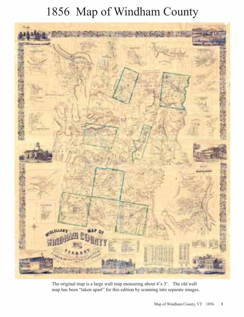
Map of Windham County, VT 1856 3
The original map is a large wall map measuring about 4’x 5’. The old wall map has been “taken apart” for this edition by scanning into separate images.
1856 Map of Windham County

4 Map of Windham County, VT 1856 ©2005 www.old-maps.com
During a short period of time in the decade preceding the Civil War, an extraordinary series of detailed county maps was produced, which recorded the names and locations of homes and businesses throughout the Northeastern United States. In 1856, early in this period of county mapmaking, McClellan’s Map of Windham County, Vermont was pub-lished. This was the first comprehensive map of Windham County.
Little is known about the Philadelphia firm of C. McClellan & Co. (the producers of the map). Of the hundreds of county maps produced in the 1850s, the name C. McClellan appears on only this one. In contrast, the name of the surveyor, J. Chace, Jr., is associated with at least eighteen other county maps in the period 1854-1860. Chace was surveyor for maps of Rutland, Windsor and Windham counties in Vermont, as well as for county maps in Maine, New York and New Hampshire. Like many of the map publishers, Chace was based in Philadelphia, although the Windham County map lists his address as Troy, New York.
Records of the survey methods used and of the sales tech-niques have been hard to find. Based on research done into other county maps, however, it is possible to speculate with some confidence. Surveyor Chace traveled the roads of Windham County, carrying notebooks and measuring de-vices. He used a wheeled odometer, probably horse-drawn, to measure distances.
In the populated areas he may have used a hand propelled odometer similar to the one pictured here. He used a com-pass to determine the bearings of roads and the locations of hills and other geographic features. As he recorded the cartographic data, the surveyor would also note the locations of the principal buildings, and, more importantly, the names of the owners. This was the point of printing the map, a new map which, for the first time, would record the locations of all the cultural sites in the county, with the owner’s name beside each. As he noted the homeowner’s name, Chace, who was probably as much salesman as geographer, would explain the significance of the new map, and invite an advance order for it. The map was probably available only by advance subscription. The price was about five dollars, a substantial sum in the 1850s.
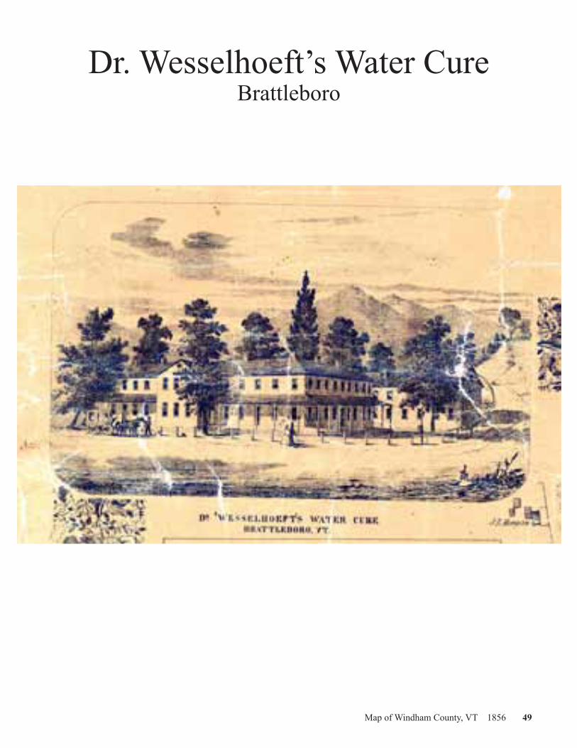
After the field work for the map was done, Chace prepared a draft which was no doubt shown around Brattleboro as he, or perhaps a sales agent, attempted to sell advertising space. Mapmakers increased their revenue by adding engraved views of local businesses—for a fee—to the margins of their maps. The price might be as high as fifty dollars per view. Note that four of the seven views on the Windham County map are of Brattleboro businesses: a melodeon factory, a furniture factory, and Brattleboro’s two water cure establish-ments. The advertising has long outlived the businesses, none of which exist today.
Drawings, or perhaps photographs of the buildings were pre-pared and sent to Philadelphia along with the draft map. In Philadelphia, the map’s designers assembled the various parts into a composite map, added a decorative border and engraved the whole onto large stone printing plates. The map was printed on four separate sheets which were then fitted and glued to a canvas backing. Each map was then hand colored. Different hues were applied to each town; slightly darker shades defined the town lines. The finished maps were varnished and mounted on wooden rollers.
The original Windham County map is not commonly seen today, which suggests that only a few may have been printed. It is among the rarest of the Vermont county maps. Its scarcity may be due to a poor sales effort by the map’s publishers. Searches in old newspapers have failed to uncover advertisements for the map of the sort used in nearby Cheshire County, New Hamp-shire, where a similar—and more commonly seen—map was produced in 1858.
Several features of the Windham County map suggest the rela-tive inexperience of its publishers. The large lettering gives certain areas of the map a cluttered appearance. In places names are hard to read, due both to the handwriting of the engraver, and to flaws in the actual printing. Additionally, the map’s accuracy in some instances is questionable. Road layouts, for example, are in many areas only generally accurate.
Variations in name spelling attract special attention. Some are clearly wrong, like “Birce Street” (Birge Street) in Brattleboro and “B.S. Paulding” (B. Spaulding) in Londonderry. Errors like these probably crept into the map when the Philadelphia engrav-ers interpreted the surveyor’s notes. Other odd spellings are less easily explained. Do the entries “Parkkus” in Townshend and “Edwads” in Wardsboro reflect misengravings? Or do they perhaps give us clues as to how some names were pronounced in 1856? We don’t know whether the surveyor actually checked the spelling of each property owner’s name, or whether he simply wrote down what he heard. Throughout the map can be seen different spellings of nearly identical names, A good example of this is seen on the maps of Brattleboro and Guilford. There, within a few miles of each other, are seen the family names “Ak-ley,” “Acley” and “Ackley.” Is this variance due to mapmaker error, or did these neighboring, and possibly related families actually spell their names three different ways?
The publication of McClellan’s Map of Windham County in a convenient atlas form should encourage the use and study of this pioneer document of Windham County history. Answers to the questions raised by this map may become evident with time and further study. Comments by readers on the map’s accuracy and insights into how this important old document was prepared are welcomed by the publisher.
This text originally appeared in the 1981 Atlas Edition of McClellan’s Map of Windham County. The Atlas Edition is now out of print.
McClellan’s Map of Windham County, VermontAn Historical Sketch of the Map
Map of Windham County, VT 1856 5
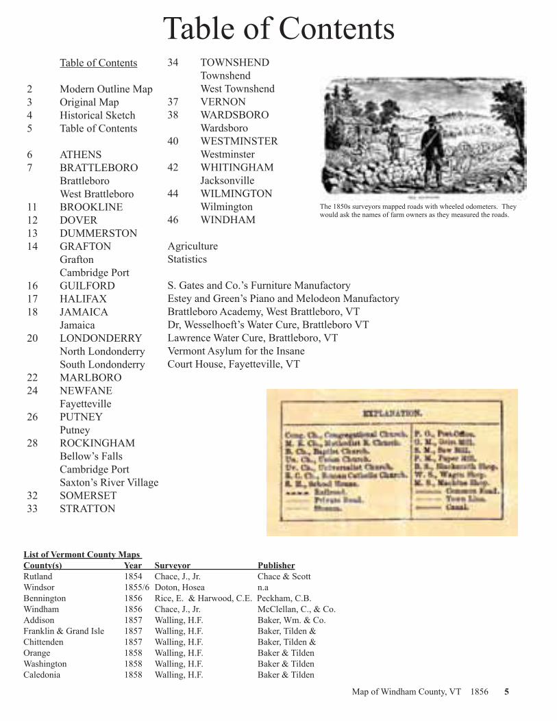
Table of Contents Table of Contents
2 Modern Outline Map3 Original Map4 Historical Sketch5 Table of Contents
6 ATHENS7 BRATTLEBORO Brattleboro West Brattleboro11 BROOKLINE12 DOVER13 DUMMERSTON14 GRAFTON Grafton Cambridge Port16 GUILFORD17 HALIFAX18 JAMAICA Jamaica20 LONDONDERRY North Londonderry South Londonderry22 MARLBORO24 NEWFANE Fayetteville26 PUTNEY Putney28 ROCKINGHAM Bellow’s Falls Cambridge Port Saxton’s River Village32 SOMERSET33 STRATTON
34 TOWNSHEND Townshend West Townshend37 VERNON38 WARDSBORO Wardsboro40 WESTMINSTER Westminster42 WHITINGHAM Jacksonville44 WILMINGTON Wilmington46 WINDHAM
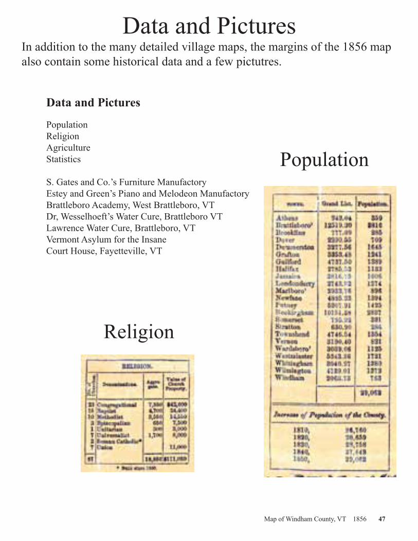
AgricultureStatistics
S. Gates and Co.’s Furniture ManufactoryEstey and Green’s Piano and Melodeon ManufactoryBrattleboro Academy, West Brattleboro, VTDr, Wesselhoeft’s Water Cure, Brattleboro VTLawrence Water Cure, Brattleboro, VTVermont Asylum for the InsaneCourt House, Fayetteville, VT
List of Vermont County Maps County(s) Year Surveyor PublisherRutland 1854 Chace, J., Jr. Chace & ScottWindsor 1855/6 Doton, Hosea n.aBennington 1856 Rice, E. & Harwood, C.E. Peckham, C.B.Windham 1856 Chace, J., Jr. McClellan, C., & Co.Addison 1857 Walling, H.F. Baker, Wm. & Co.Franklin & Grand Isle 1857 Walling, H.F. Baker, Tilden & Chittenden 1857 Walling, H.F. Baker, Tilden & Orange 1858 Walling, H.F. Baker & TildenWashington 1858 Walling, H.F. Baker & TildenCaledonia 1858 Walling, H.F. Baker & Tilden
The 1850s surveyors mapped roads with wheeled odometers. They would ask the names of farm owners as they measured the roads.

6 Map of Windham County, VT 1856 ©2005 www.old-maps.com
ATHENS

Map of Windham County, VT 1856 7
BRATTLEBORO

8 Map of Windham County, VT 1856 ©2005 www.old-maps.com
Brattleboro

Map of Windham County, VT 1856 9

10 Map of Windham County, VT 1856 ©2005 www.old-maps.com
West Brattleboro

Map of Windham County, VT 1856 11
BROOKLINE
12 Map of Windham County, VT 1856 ©2005 www.old-maps.com
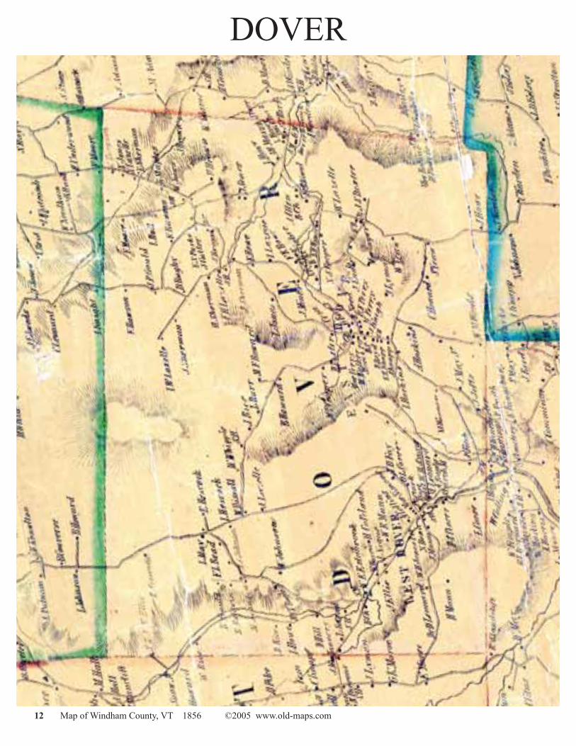
DOVER

Map of Windham County, VT 1856 13
DUMMERSTON
14 Map of Windham County, VT 1856 ©2005 www.old-maps.com
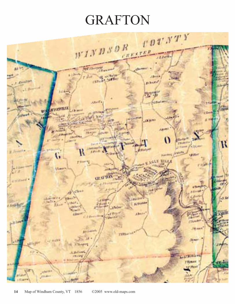
GRAFTON

Map of Windham County, VT 1856 15
Grafton

16 Map of Windham County, VT 1856 ©2005 www.old-maps.com
GUILFORD

Map of Windham County, VT 1856 17
HALIFAX
18 Map of Windham County, VT 1856 ©2005 www.old-maps.com
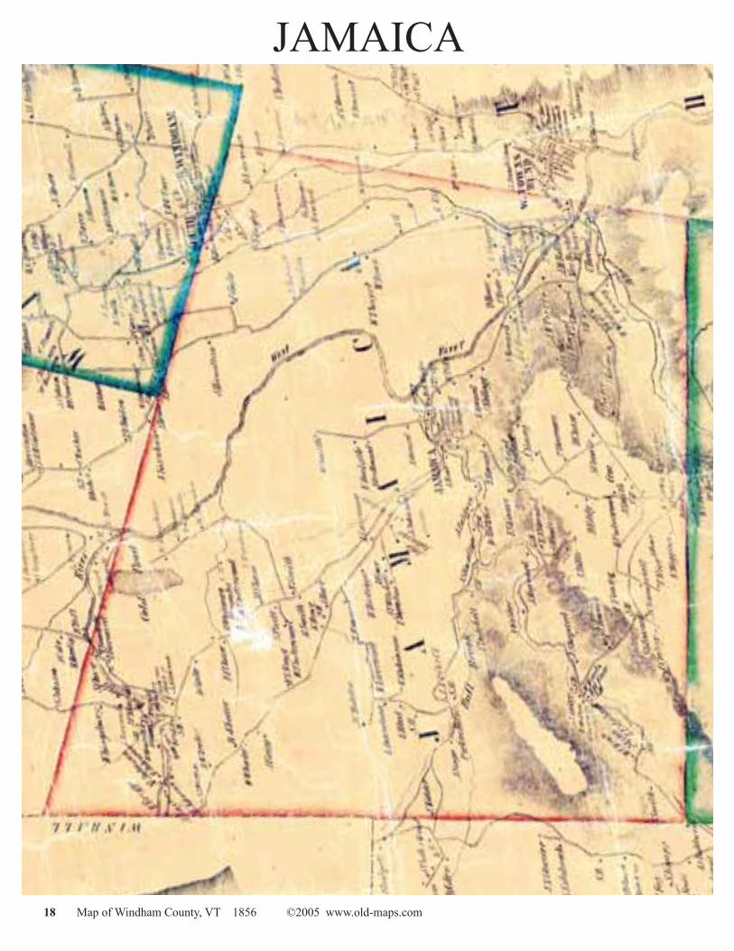
JAMAICA

Map of Windham County, VT 1856 19
Jamaica

20 Map of Windham County, VT 1856 ©2005 www.old-maps.com
LONDONDERRY

Map of Windham County, VT 1856 21
North Londonderry
South Londonderry

22 Map of Windham County, VT 1856 ©2005 www.old-maps.com
MARLBORO

Map of Windham County, VT 1856 23
This page intentionally left blank

24 Map of Windham County, VT 1856 ©2005 www.old-maps.com
NEWFANE

Map of Windham County, VT 1856 25
Fayetteville

26 Map of Windham County, VT 1856 ©2005 www.old-maps.com
PUTNEY

Map of Windham County, VT 1856 27
Putney

28 Map of Windham County, VT 1856 ©2005 www.old-maps.com
ROCKINGHAM

Map of Windham County, VT 1856 29
Cambridge Port
Saxton’s River Village

30 Map of Windham County, VT 1856 ©2005 www.old-maps.com
Bellows Falls

Map of Windham County, VT 1856 31

32 Map of Windham County, VT 1856 ©2005 www.old-maps.com
SOMERSET

Map of Windham County, VT 1856 33
STRATTON
34 Map of Windham County, VT 1856 ©2005 www.old-maps.com
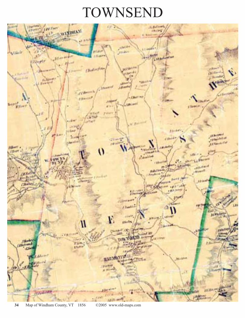
TOWNSEND

Map of Windham County, VT 1856 35
Townsend

36 Map of Windham County, VT 1856 ©2005 www.old-maps.com
West Townsend

Map of Windham County, VT 1856 37
VERNON

38 Map of Windham County, VT 1856 ©2005 www.old-maps.com
WARDSBORO

Map of Windham County, VT 1856 39
Wardsboro

40 Map of Windham County, VT 1856 ©2005 www.old-maps.com
WESTMINSTER

Map of Windham County, VT 1856 41
Westminster

42 Map of Windham County, VT 1856 ©2005 www.old-maps.com
WHITINGHAM

Map of Windham County, VT 1856 43
Jacksonville

44 Map of Windham County, VT 1856 ©2005 www.old-maps.com
WILMINGTON

Map of Windham County, VT 1856 45
Wilmington

46 Map of Windham County, VT 1856 ©2005 www.old-maps.com
WINDHAM
Map of Windham County, VT 1856 47
Data and PicturesIn addition to the many detailed village maps, the margins of the 1856 map also contain some historical data and a few pictutres. Data and Pictures Population Religion Agriculture Statistics S. Gates and Co.’s Furniture Manufactory Estey and Green’s Piano and Melodeon Manufactory Brattleboro Academy, West Brattleboro, VT Dr, Wesselhoeft’s Water Cure, Brattleboro VT Lawrence Water Cure, Brattleboro, VT Vermont Asylum for the Insane Court House, Fayetteville, VT
Population
Religion

48 Map of Windham County, VT 1856 ©2005 www.old-maps.com
Agriculture
Statistics
Map of Windham County, VT 1856 49
Dr. Wesselhoeft’s Water CureBrattleboro

50 Map of Windham County, VT 1856 ©2005 www.old-maps.com
Vermont Asylum for the InsaneW.H. Rockwell, MD Supt

Map of Windham County, VT 1856 51
Court HouseFayetteville

52 Map of Windham County, VT 1856 ©2005 www.old-maps.com
Lawrence Water CureBrattleboro

Map of Windham County, VT 1856 53
Gates and Co.’sFurniture Manufactory
Brattleboro

54 Map of Windham County, VT 1856 ©2005 www.old-maps.com
Brattleboro AcademyWest Brattleboro

Map of Windham County, VT 1856 55
Estey and Green’s Piano andMelodeon Manufactory
Brattleboro

56 Map of Windham County, VT 1856 ©2005 www.old-maps.com
1856 Map of Windham County