map: ansel adams wilderness addition -...
TRANSCRIPT
!.
!.
!.
!.
!.
!.
!.
!.
!.
!.
!.
!.
!.
Tollhouse
Coarsegold
El Portal
Friant
LeeVining
Bishop
Big Pine
Mariposa
Auberry
Oakhurst
Midpines
MammothLakes
JuneLake
SIERRA
FOREST
FOREST
NATIONAL
¬«120
¬«108
Humboldt-ToiyabeNationalForest
InyoNationalForest
SequoiaNational Forest
StanislausNationalForest
SierraNationalForest
¬«167
¬«158
¬«49
¬«41
¬«270¬«182
¬«6
¬«395
¬«140
¬«145
¬«203
¬«773
¬«95¬«359
¬«168
¬«360
¬«264
¬«120
USDA Forest Service - Pacific Southwest RegionInyo National ForestMap Creation Date -
Pacific Southwest Region - Information Management
Vicinity Map
Ansel Adams Wilderness Addition - Northeast
Approximately 7,212 AcresTownship 1 North - 2 South, Range 25-26 East
Mount Diablo Meridian, Mono County, CA
ReferencesData acquired from a variety of sources of differingaccuracy, precision and reliability. Featuresrepresented by these data may not representaccurate geographic locations.
The USDA Forest Service makes no warranty, expressed or implied regarding the data displayed on this map, and reserves the right to correct, update, modify, or replace this information without notification.
Disclaimer
0 1 20.5Miles
±
Draft Environmental Impact Statement for Revision of the Inyo, Sequoia, and SierraNational Forest Land Management Plans
This map is designed for Forest Serviceplanning purposes only. It only represents areas being analyzed and does not conveyfuture recommendations. It does notcontain sufficient detail for legal purposes.
Area analyzed that may besuitable for inclusion in theNational Wilderness PreservationSystemUSFS Designated WildernessUSFS LandsNon-USFS LandsBLM Designated Wilderness
5/13/2016
Derived from Evaluation Polygon 1179

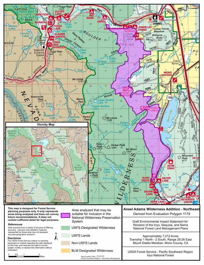
Map: Ansel Adams Wilderness Addition - Northeast Potential Recommended Wilderness Area
This map displays a potential recommended wilderness area that would be an addition to the existing
Ansel Adams Wilderness. This recommendation was derived from Wilderness Evaluation Polygon #1179
and the area is 7,212 acres. The boundary is contiguous with the Ansel Adams Wilderness along the
western boundary. However, the polygon is elongated vertically from north to south and roads and
private land parcels protrude into the polygon along the eastern edge, making for an irregularly shaped
boundary. Some of the eastern boundary follows roads and is more easily identifiable. The Los Angeles
Department of Water and Power manages lands adjacent to the boundary.