malua wildlife habitat conservation project area
TRANSCRIPT

MALUA WILDLIFE HABITAT
CONSERVATION PROJECT AREA
QUARTERLY OPERATION REPORT
JANUARY-MARCH 2012

TABLE OF CONTENTS
Executive Summary
1.0 PROTECTION ACTIVITIES
2.0 WILDLIFE MONITORING AND OBSERVATION PROGRAM
2.1 Night Spot
2.2 River Monitoring
2.3 Orang Utan Nest Counting
2.4 Opportunistic Sightings
2.5 Recce Walks
3.0 OTHER MONITORING ACTIVITIES
3.1 Camera Trapping
3.2 Saltlick Inspection
3.3 Artificial Nesting Boxes
3.4 Orang Utan Bridges
3.5 Road Kills
4.0 INFRASTRUCTURE DEVELOPMENT
5.0 FIELD EQUIPMENT
6.0 TRANSPORTATION, COMMUNICATION AND LOGISTIC
7.0 FUEL CONSUMPTION
Annex 1: A list of wildlife species found and recorded within Malua FR
Annex 2: Adhoc/Opportunistic Wildlife Sighting, January to March 2012
Annex 3: Orang Utan Nest Counting, December 2011 to March 2012 [9th to 11th Survey]
Annex 4: Datasheet for night spot activity carried out in January to March 2012

Executive Summary
For the first quarter year 2012, security and protection is strongly focused in northern and eastern
Malua Forest Reserve as these areas were identified as high risk to intrusion and should be the focus
of monitoring. Routine ground patrolling and monitoring is regularly carried out by Forestry Department
Enforcement Unit to ensure the particular areas along the common boundary to Oil Palm plantations
are protected and safe from any type of forest offence. Other enforcements activities carried out include
controlling and monitoring the main security gate at FCS 57 and conducting night patrolling along the
accessible road within Malua Forest Reserve especially the main road and adjacent roads common to
the palm oil estates.
The Protection Units led by Zainal Kula and Ismail Abd Samad have consistently kept contact with the
nearest oil palm plantations and nearest villages. The protection team had successful meetings and
discussion with plantations workers and local people from Kampung Balat, Kampung Kuamut,
Kampung Tulang-Tulang, Kampung Desa Permai and Kampung Sangau which was associated with
several issues relating to forest offences. Most people are willing to cooperate and give full support to
the Malua team, especially the local people from Kampung Balat.
Routine wildlife monitoring and observation activities such as night spotting, river monitoring, recce
walks, artificial saltlick inspections, observation of artificial nesting boxes, camera trapping and Orang-
utan bridge monitoring in north Malua were completed by the Wildlife Team. The Orang-utan ground
nest counting also was completed successfully, the 9th, 10th and 11th survey of the seven permanent
transects in three different rainforest rehabilitation treatments was completed. In addition, in this quarter
the wildlife team attended and completed general wildlife training organized by WWF-Malaysia [Borneo
Species Programme] in March 2012. It was beneficial as the Malua Wildlife Unit has increased
understanding about wildlife monitoring studies and fieldwork requirements.

1
1.0 PROTECTION ACTIVITIES
Activity that was conducted by protection team in 1st quarter [January to March 2012] shows as table below;
Forest Checking Station 57 [FCS 57]
Objective Activity Finding/Result Remarks
To prevent any *illegal activity such as encroachment and wildlife poaching or detrimental activity such as lighting of fires from being undertaken within or close to the Malua boundary.
Each month the boundary from compartment from 54 to 63 will be inspected by vehicle and foot. To ensure no encroachments happened between Malua FR and Kuamut FR. Any issues will be logged and reported
No illegal activity was recorded for the period of inspection
- 15 days every month
Undertake night patrols at random times but particularly during days off and weekend.
No hunting activity recorded during the night patrol undertaken
every weekend & off day [public holiday etc]
Installation and maintenance of the FD warning plate (South Malua in between to Kuamut FR)
In this quarter, there is no notification FD plate installed
Purchase 200 pieces of notification FD plate - pending
Control and monitor the security gate at FCS 57. Inspect any vehicle passing through from the gate especially vehicle from Kuamut FR. Ensure no hunting or encroachers vehicle come in. Gate operation from 6:00am until 9:00pm.
Managed well and no issue was reported either poaching or intimidation against staff since the gate installed
every day
Ensure that there is no garbage, expired tyres and discarded oil within Malua FR
Regular inspection along Malua main road from FCS 57 to compartment 49 and FCS Ulu Segama as well. Any issue will be recorded and deal with people using Malua main road regularly and Sabah BioD Exp as well
No expired tyres or discarded oil recorded during the inspection made. However, plastic and water bottle thrown found in certain place along the main road within Malua FR.
4 days/week
To improve communication and raise awareness in term of wildlife conservation and related issue
Conduct discussions with SBE staff and use it as an opportunity to gather formal data and raise awareness and ensure they are not undertaking any illegal activities. This will be formally documented and the outcomes of the
SBE staff understanding of the offense and the prohibition of any illegal activity within forest reserves especially in Malua rehabilitation project area
once a month

2
discussion will be followed up
Aerial surveillance using helicopter to Controlling and Prevention encroachments entire Maluaa FR
Search and find any illegal activity from the air - entire Maluaa Forest Reserve
Nil
Joint with Ulu Segama Protection team & the schedule depends on the US Protection Unit
Administrative and maintenance duties require each month
maintenance FCS and surround, vehicle and undertake administrative task
Cleaning and cutting grass around the checking station as well as the project signboards in compartment 57 and 49 week a month
Forest Checking Station 37 [FCS 37] Objective Activity Finding / Result Remarks
To prevent any *illegal activity such as wildlife poaching, felling of trees, or detrimental activity such as lighting of fires or disposal of waste materials from being undertaken within or close to the Malua boundary.
Each month the boundary from compartment from 38 to 20 (east Malua) will be inspected twice either from vehicle or on foot. ‘Hot spot’ areas to be monitored at least three times a month. All areas inspected will be recorded by GPS and any issues will be logged and dealt with according to agreed procedures.
January to March 2012, 5 wildlife traps were found within Malua FR on the common boundary with Kwantas estate. The wildlife traps found were destroyed and an official warning letter given to the estate
15 days every month
Each main estate security gate (Ladang Erat, Segamaha and Pintasan 1) will be checked once a week during the day off and also during the evenings after 6pm. Records should be kept of these checks and any issues recorded and dealt with.
Protection unit headed by Ismail Abd Samad and his assistant meet with security gate keeper in Ladang Erat and Segamaha Estate to gathering any information regarding poaching issue. Based on interview made, most of gate keeper reported that legal and illegal poachers those looking for wild pig more often enter the estate
Each gate will be checked a minimum of once a week during the day and once a week during the evening (day and time will be random and decided each week).
To improve communication, raise awareness and improve reporting of wildlife poaching or human-wildlife conflict issues by the estates community.
The four [Pintasan 5F, Pintasan 5A, Pintasan 5B and Ladang Erat] Estate managers and key staff will be meeting monthly and a record will be kept of the meetings.
As planned, the protection unit had a series of meeting with the key plantations which purposely to raise awareness and to improve communication
4 days/month
In addition formal meetings will be conducted with Estate Managers with the ADFO present to discuss any breaches/issues found. This will be formally documented and the outcomes of the meeting will
January to March 2012, there is no formal meeting made to discuss about the wildlife traps found but we have giving out warning letter to the related plantation.
1 day when needed

3
be followed up.
Formal slide presentation to Estate Management & Workers
There is no slide presentation made for this first quarter
1 day/month
Conduct informal discussions with estate workers and use it as an opportunity to gather informal data and raise awareness on conservation issues for Malua.
Several plantation workers was interviewed and discuss some issue about conservation effort carry out in Malua. Most of the workers that were met understand what we explained.
During boundary patrol
Inspection and observation of any illegal activity such as encroachment and burning activity from the air - using helicopter
Search and find any illegal activity entire Malua Forest Reserve
Conducted once in February. No illegal activity found during the inspection.
Joint with Ulu Segama Protection team & the schedule depends on the US Protection Unit
Administrative and maintenance duties required each month
Maintenance of FCS and surround, vehicle and undertake administrative task
Cleaning surrounded the field station and undertake some administrative task
one day/month
Forest Checking Station 15 [FCS 15]
Objective Activity Finding / Result Remarks
To prevent any *illegal activity such as wildlife poaching or detrimental activity such as lighting of fires or disposal of waste materials from being undertaken within or close to the Malua boundary.
Each month the boundary from compartment from 19 to 7 will be inspected twice either from vehicle or on foot. ‘Hot spot’ areas to be monitored at least three times a month. All areas inspected will be recorded with GPS and any issues will be logged and dealt with according to agreed procedures.
Human trail and wildlife trap found within compartment 8 and 9. The traps were found been destroyed. The hot spot areas were regularly monitored and more than three times a month. There is no encroachment found for the period of survey made.
15 days every month
Undertake night patrols at random times but particularly during days off for estate workers and weekends.
Undertake night patrolling along estate road which is in adjacent to Malua area. First quarter in January to March 2012, there is no hunting cases were reported for the period of night patrolling.
every weekend & off day [public holiday etc]
Each main #security gate (Syarimo 2, Ladang Pin 7, Pintasan 8) will be checked once a week during the day off and also during the evenings
Interview and inspect security gate in Pintasan 8 and Tung Hup [Ladang Pin 7]. The gate keeper had reported to us
Each gate will be checked minimum of once a week during the

4
after 6pm. Records should be kept of these checks and any issues recorded and dealt with.
that legal wild pig hunters quite often pass through to the gate
day and once a week during the evening (day and time will be random and decided each week)
Prevention felling tree along the river bank and poaching as well
River patrolling and Monitoring - more often during flood, normally starting from downstream of Sg Malua and up to compartment 23
Malua River is easy access to get into Malua and this prompts the protection team to execute river patrolling more often when in flood. Currently, there is no illegal activity found along the river during the patrolling carried out in January to March 2012
Minimum of 2/days per week when river is high
To improve communication, raise awareness and improve reporting of wildlife poaching or human-wildlife conflict issues by the estates and the nearest villagers.
Formal meetings will be conducted with Estate Managers with the ADFO present to discuss any breaches/issues found. This will be formally documented and the outcomes of the meeting will be followed up
Informal meeting with Pintasan 8 and Ladang Pin estate Manager to discuss some issue related to conservation effort in Malua and forest offences
1 day
Conduct informal discussions with estate workers and use it as an opportunity to gather informal data and raise awareness on conservation issues for Malua.
As usual, the protection team led by Zainal and his assistance had interview some workers from Pintasan 8 and Tung Hup [Ladang Pin 7] estate which purposely to get informal data and to raise awareness to estate workers about conservation effort in Malua
During boundary patrol and monitoring
Three [Pintasan 5F, Ladang Pin 7 and Pintasan 8) Estate managers and key staff will meet monthly and a record will be kept of the meetings.
Carried out and organized by forest protection unit team leader in FCS 15. So far, the estate manager understand our program and they have a good cooperation with staff’s duty in North Malua
4 days/month
Conduct informal meetings, presentations and discussions with 4 villagers [namely Kg Balat, Kg Sangau, Kg Tulang-Tulang, Kg Kuamut]
Postponed because any others official duties and some problems that cannot avoided
1 day/month
Aerial surveillance using helicopter Search and find any illegal activity from the air Executed once in March 2012. No Joint with Ulu Segama

5
to Controlling and Prevention encroachments entire MaluaFR
entire Malua Forest Reserve illegal issue was recorded during the inspection
Protection team & the schedule depends on the US Protection Unit
Administrative and maintenance duties require each month
maintenance FCS and surround, vehicle and undertake administrative task
Cleaning surround the field station and undertake some administrative task
one day/month

6
Map 1: Zoning for patrolling and monitoring area to be controlled by each protection unit

7
Table: Numbers of Illegal activities detection since year 2009 to January-March 2012
Illegal Activity Year 2009
Year 2010
Jan-March 2011
April-June 2011
July-Sept 2011
Oct-Dec 2011
Jan-Mar2012
Logging 0 0 0 0 0 0 0 Forest Fire 0 0 0 0 0 0 0 Cultivation 1 0 0 0 0 0 0 Poaching 5 5 0 0 0 0 0 Conversion Fallen Tree 0 0 0 0 0 0 0 Felling Tree 2 0 0 0 0 0 0 Gaharu Thief 0 0 0 0 1 0 0 Campground 1 0 0 0 0 0 0 Human Trail/Track/Wildlife Trap 5 3 0 0 3 7 5
Figure: Scenario some selected illegal activity that more frequently occur within Malua FR
The graph above highlights the most common illegal activities – setting of snare traps and signs of entry for hunting found by protection team since 2009 to March 2012 in Malua Forest Reserve.
January to March 2012, the protection team found 5 cases of wildlife snare traps being set, which were destroyed in eastern and northern Malua FR. We believe the traps were made by plantation workers and a warning letter was given to Kwantas Estate.
8
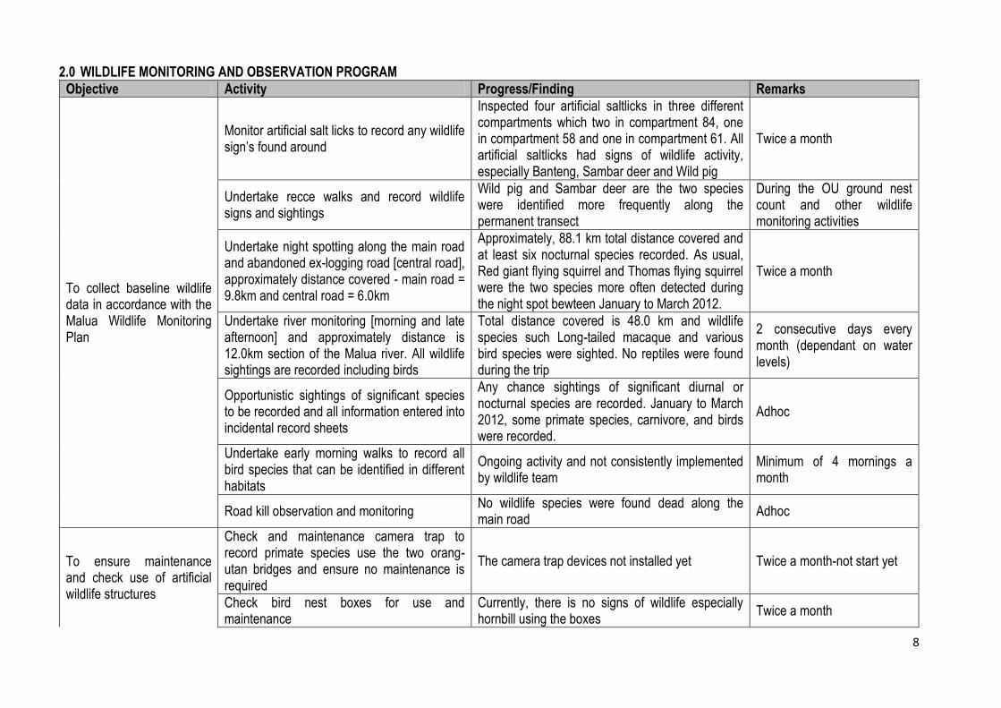
2.0 WILDLIFE MONITORING AND OBSERVATION PROGRAM
Objective Activity Progress/Finding Remarks
To collect baseline wildlife data in accordance with the Malua Wildlife Monitoring Plan
Monitor artificial salt licks to record any wildlife sign’s found around
Inspected four artificial saltlicks in three different compartments which two in compartment 84, one in compartment 58 and one in compartment 61. All artificial saltlicks had signs of wildlife activity, especially Banteng, Sambar deer and Wild pig
Twice a month
Undertake recce walks and record wildlife signs and sightings
Wild pig and Sambar deer are the two species were identified more frequently along the permanent transect
During the OU ground nest count and other wildlife monitoring activities
Undertake night spotting along the main road and abandoned ex-logging road [central road], approximately distance covered - main road = 9.8km and central road = 6.0km
Approximately, 88.1 km total distance covered and at least six nocturnal species recorded. As usual, Red giant flying squirrel and Thomas flying squirrel were the two species more often detected during the night spot bewteen January to March 2012.
Twice a month
Undertake river monitoring [morning and late afternoon] and approximately distance is 12.0km section of the Malua river. All wildlife sightings are recorded including birds
Total distance covered is 48.0 km and wildlife species such Long-tailed macaque and various bird species were sighted. No reptiles were found during the trip
2 consecutive days every month (dependant on water levels)
Opportunistic sightings of significant species to be recorded and all information entered into incidental record sheets
Any chance sightings of significant diurnal or nocturnal species are recorded. January to March 2012, some primate species, carnivore, and birds were recorded.
Adhoc
Undertake early morning walks to record all bird species that can be identified in different habitats
Ongoing activity and not consistently implemented by wildlife team
Minimum of 4 mornings a month
Road kill observation and monitoring No wildlife species were found dead along the main road
Adhoc
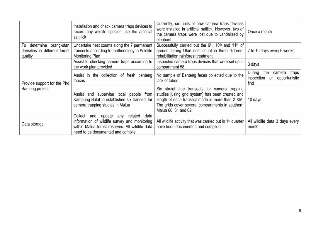
To ensure maintenance and check use of artificial wildlife structures
Check and maintenance camera trap to record primate species use the two orang-utan bridges and ensure no maintenance is required
The camera trap devices not installed yet Twice a month-not start yet
Check bird nest boxes for use and maintenance
Currently, there is no signs of wildlife especially hornbill using the boxes
Twice a month
9
Installation and check camera traps devices to record any wildlife species use the artificial salt lick
Currently, six units of new camera traps devices were installed in artificial saltlick. However, two of the camera traps were lost due to vandalized by elephant.
Once a month
To determine orang-utan densities in different forest quality
Undertake nest counts along the 7 permanent transects according to methodology in Wildlife Monitoring Plan
Successfully carried out the 9th, 10th and 11th of ground Orang Utan nest count in three different rehabilitation rainforest treatment
7 to 10 days every 6 weeks
Provide support for the Phd Banteng project
Assist to checking camera traps according to the work plan provided
Inspected camera traps devices that were set up in compartment 58
3 days
Assist in the collection of fresh banteng faeces
No sample of Banteng feces collected due to the lack of tubes
During the camera traps inspection or opportunistic find
Assist and supervise local people from Kampung Balat to established six transect for camera trapping studies in Malua
Six straight-line transects for camera trapping studies [using grid system] has been created and length of each transect made is more than 2 KM. The grids cover several compartments in southern Malua 60, 61 and 62.
10 days
Data storage
Collect and update any related data information of wildlife survey and monitoring within Malua forest reserves. All wildlife data need to be documented and compile
All wildlife activity that was carried out in 1st quarter have been documented and compiled
All wildlife data 3 days every month

10
In the first quarter for 2012 [January to March 2012], the Malua Wildlife team successfully conducted their routine wildlife observations and monitoring. The key activities included night spots, river monitoring, Orang-utan nest counts, recce walks, and documentation of opportunistic sightings of wildlife species within Malua forest reserve. Others observation such as camera trapping, saltlicks inspection, OU bridges, artificial nesting boxes also were accomplished by the wildlife team.
However, some activities such as setting up camera traps to monitor both Orang Utan bridges in northern Malua is not yet complete and it has been postponed due to budget constraints. The wildlife activities were completed according to the work plan, some field operations are influenced by weather and staff movements.
2.1 Night Spotting
Night spot was conducted along two different routes (called main and central roads) to gather wildlife data on
nocturnal species within Malua. This is currently executed twice a month by Malua Wildlife Unit.
Detailed information and findings are tabled below.
2.1.1 Malua Main Road
Table 1: Distance covered and survey period for night spot along Malua main road
Month / Year Survey Routes
Dist Covered (km) Period of Survey
Average Distance covered [km]
January to March 2012
Main Road 52.6 6 8.8
Small Toothed Palm Civet
Red Giant Flying Squirrel Sambar Deer
Thomas flying Squirrel
Common Palm Civet Leopard Cat
Others [Birds & Reptile]
Nb
of
dete
ctio
n
Avr
de
tect
ion
Frq
dete
ctio
n
Nb
of
dete
ctio
n
Avr
de
tect
ion
Frq
dete
ctio
n
Nb
of
dete
ctio
n
Avr
dete
ctio
n
Frq
de
tect
ion
Nb
of
dete
ctio
n
Avr
dete
ctio
n
Frq
de
tect
ion
Nb
of
dete
ctio
n
Avr
dete
ctio
n
Frq
de
tect
ion
Nb
of
dete
ctio
n
Avr
de
tect
ion
Frq
dete
ctio
n
Nb
of
dete
ctio
n
Avr
de
tect
ion
Frq
dete
ctio
n
8 1.33
0.15 11
1.83
0.21 7
1.17
0.13 4
0.67
0.08 1
0.17
0.02 1
0.17
0.02 2
0.33
0.04
Table 2: Frequency detection some nocturnal species per km
Wildlife Species Frequency Detection per KM
Small Toothed Palm Civet 0.15
Red Giant Flying Squirrel 0.21
Sambar Deer 0.13
Thomas Flying Squirrel 0.08
Common Palm Civet 0.02
Leopard Cat 0.02
Other [Birds& Reptiles] 0.04
52.6km of distance has covered during the night spot carry out along the main road in January to March
2012 and 6 nocturnal species were recorded and identified. This species are the most frequently
detected along the roadside. However, for the first quarter the nocturnal species were recorded less
than previous, this variation might be caused by food availability along the road.

11
Graph: shows the frequencies and variation of nocturnal species detection per KM
2.1.2 Malua Central Road
Table: Distance covered and survey period for night spot along Malua central road
Month /year Dist Covered (km) Period of Survey Average Distance [KM]
Jan-Mar 2012 35.5 6 5.9 Small Toothed
Palm Civet Red Giant Flying
Squirrel Sambar Deer Thomas flying
Squirrel Common Palm
Civet Malay Civet
Nb
of
dete
ctio
n
Avr
dete
ctio
n
Frq
dete
ctio
n
Nb
of
dete
ctio
n
Avr
dete
ctio
n
Frq
dete
ctio
n
Nb
of
dete
ctio
n
Avr
dete
ctio
n
Frq
dete
ctio
n
Nb
of
dete
ctio
n
Avr
dete
ctio
n
Frq
dete
ctio
n
Nb
of
dete
ctio
n
Avr
dete
ctio
n
Frq
dete
ctio
n
Nb
of
dete
ctio
n
Avr
dete
ctio
n
Frq
dete
ctio
n
1 0.17 0.03 6 1.00 0.17 4 0.67 0.11 7 1.17 0.20 2 0.33 0.06 1 0.17 0.03
Table: Frequency detection some nocturnal species per km
Wildlife Species Frequency Detection per KM
Small Toothed Palm Civet 0.03
Red Giant Flying Squirrel 0.17
Sambar Deer 0.11
Thomas Flying Squirrel 0.2
Common Palm Civet 0.06
Malay Civet 0.03
Graph: Frequencies and variation of nocturnal species detection per KM along central road

12
35.9km of distance covered for night spot along the central road in January to March 2012 and 6
nocturnal species were recorded. Red Giant and Thomas flying squirrel were most frequently detected.
However, for the first quarter, all species of civet were recorded less than previous and this may be sue
to changes in food availability along the road.
Table and graph below show a comparison of nocturnal species detected along the two different routes
during the night spot carry out in January to March 2012.
Table: Frequencies of nocturnal species detection in both routes
Wildlife Species
Frequency Detection per KM
Main Road Central Road
Small Toothed Palm Civet 0.15 0.03
Red Giant Flying Squirrel 0.21 0.17
Sambar Deer 0.13 0.11
Thomas Flying Squirrel 0.08 0.2
CommonPalm Civet 0.02 0.06
Leopard Cat 0.02 0
Other [Birds& Reptiles] 0.04 0
Malay Civet 0 0.03
Graph: Comparison of nocturnal species detection both survey route for night spot
For the first quarter 2012, as usual flying squirrel such as Red Giant and Thomas flying squirrel are the
two species most commonly and frequently detected along the accessible roads in Malua forest
reserve, followed by Small toothed palm civet and Sambar deer.
Three nocturnal species [Common palm civet, Leopard cat and Malay civet] were recorded and seen a
few times during the night spot in January to March 2012. There is no scientific and detailed
explanation, but concentration of food abundance along the roads might change the distribution of
these species.

13
2.2 River Monitoring
Table below presents the wildlife species detected and frequencies per KM during the river monitoring
and observation.
Long-tailed Macaque and some bird’s species [such as Pied Hornbill, Oriental Darter, Kingfisher etc)
were most commonly detected during the observation period. Food availability along the riverbank
might may influence species observed in this area.
Table: distance and survey period for river monitoring and observation in first quarter
Month /year Dist Covered (km) Period of Survey Average Distance [KM]
Jan-Mar 2012 48 4 12.0
Long Tailed Macaque Birds Species Reptiles Species
Nb of detection
Average detection
Frequency detection
Nb of detection
Average detection
Frequency detection
Nb of detection
Average detection
Frequency detection
44 11.00 0.92 81 20.25 1.69 0 0.00 0.00
Table and graph below shows the frequencies of some riparian species detection during the river monitoring carry out for month of January to March 2012. This first quarter, there were not as many riparian wildlife species recorded comparing to the pervious observation in December 2011.
Wildlife Species Frequency Detection per KM
Long tailed macaque 0.92
Birds 1.69
Reptiles 0
River monitoring and observation in north Malua [Malua River] has carried out by Wildlife team and
assisted by protection staff. The operation was conducted once a month, normally early morning and
late afternoon.
For this quarter, the wildlife team covered approximately 48 KMs for four successive survey periods.
The graph shows that, long tailed macaque and birds species [such as pied hornbill, Eagle, Kingfisher,
Egret, Pigeon etc] are the wildlife species detected in the highest numbers per KM.

14
2.3 Orang Utan Nest Count
Accomplished the 9th 10th and 11th ground Orang-utan nest count for seven permanent lines transects established in three different rainforest rehabilitation treatments. The Wildlife team spent about 8 days each survey to cover the transects.
Distance covered for each survey is 27340m [27.34km] and 212 new Orang-utan nests were recorded. Generally, the Orang-utan nests found were built in medium-size trees and lower parts of the larger trees.
Table 1 to table 5 below showing detail information of permanent transect in different rainforest rehabilitation treatments;-
Table1: General description of location the permanent line transects for Orang-Utan
Location Compartment /
Area Transect
Name Bearing
Actual Length
GPS
Starting Ending
Malua South [cpt 58+52]
58 Dol 180 2000 RY879578/BOR564386 RY879651/BOR562480
52 Roy 360 2000 RY880972/BOR565571 RY881048/BOR567512
Total 4000
Malua North 15/16 Omar 90 2000 RY879777/BOR587544 RY881762/BOR587637
Total 2000
Sabah BioD [A+B]
85 A 180 300 N05o05’12.1”E117o39’02.1” N05o04’14.0”E117o39’00.9”
B 180 1000 N05o17’8’’E117o39’17”
Total 1300
Infapro [A +B]
A 360 1000 RY904263 / BOR554710 RY904320 / BOR 555674
B 90 2000 RY904263 / BOR554710
Total 3000
Table 2: Nests found within strip width and outlier for each count and survey area
Location / Area
Survey 1 Survey 2 Survey 3
Nb Nest
Nb Outlier
W1 Nb Nest
[W1] Nb
Nest Nb
Outlier W1
Nb Nest [W1]
Nb Nest
Nb Outlier
W1 Nb Nest
[W1]
Malua South
66 5 9.38 35 20 7 10.82 8 10 - 10.7 7
Malua North
43 4 7.97 15 15 7 9.53 2 9 1 8.2 6
Sabah BioD
22 1 13.4 11 5 - 13.13 2 3 - 12.89 1
Infapro 151 9 11.42 81 14 - 13.17 3 16 - 12.74 14
Location /Area
Survey 4 Survey 5 Survey 6
Nb Nest
Nb Outlier
W1 Nb Nest
[W1] Nb
Nest Nb
Outlier W1
Nb Nest [W1]
Nb Nest
Nb Outlier
W1 Nb Nest
[W1]
Malua South
32 1 13.39 32 16 - 11.49 8 54 4 9.1 4
Malua North
26 - 15.08 26 40 3 12.6 7 49 4 12.61 8
Sabah BioD
15 - 14.61 15 21 - 12.79 3 20 - 13.4 0
Infapro 37 3 12.72 37 17 1 17.02 8 71 3 13.03 4

15
Location / Area
Survey 7 Survey 8 Survey 9
Nb Nest
Nb Outlier
W1 Nb Nest
[W1] Nb
Nest Nb
Outlier W1
Nb Nest [W1]
Nb Nest
Nb Outlier
W1 Nb Nest
[W-1]
Malua South 18 - 12.48 9 23 - 15.04 12 20 - 13.21 10
Malua North 6 - 12.4 3 20 - 15.43 10 23 - 17.5 13
Sabah BioD 7 - 11.5 4 13 - 12.48 7 15 - 16.56 11
Infapro 19 - 13.08 9 14 - 9.51 7 16 - 10.91 9
Location/Area Survey 10 Survey 11
Nb Nest Nb Outlier W1 Nb Nest [W1] Nb Nest Nb Outlier W1 Nb Nest [W1]
Malua South 26 - 17.12 13 10 - 10.18 4
Malua North 9 - 17.11 4 13 - 14.5 10
Sabah BioD 24 - 16 10 7 - 12.16 4
Infapro 21 - 15.75 11 28 - 8.75 8
Table 3: Date and time intervals between successive surveys and result “t”
Location Transect
Name
Survey 1 Survey 2 Survey 3 Survey 4
Date Nest
decay rate “t”
Date Nb
Days "t" Date
Nb Days
"t" Date Nb
Days "t"
Malua South
Dol (cpt58)
23.11.10 183.8
11.01.11 48 45.5
23.03.11 71 71
11.05.11 49 50.5
Roy (cpt 52)
30.11.10 12.01.11 43 24.03.11 71 15.05.11 52
Malua North
Omar 01.12.10 146.1 17.01.11 47 47 31.03.11 73 73 18.05.11 49 49
Sabah BioD
A 25.11.10 164.3
13.01.11 49 49
27.03.11 73 73
14.05.11 48 48
B 25.11.10 13.01.11 49 27.03.11 73 14.05.11 48
Infapro A 26.11.10
170.1 15.01.11 50
50 26.03.11 70
70 13.05.11 47
47 B 26.11.10 15.01.11 50 26.03.11 70 13.05.11 47
Location Transect
Name
Survey 5 Survey 6 Survey 7 Survey 8
Date Nb
Days "t" Date
Nb Days
"t" Date Nb
Days "t" Date
Nb Days
"t"
Malua South
Dol (cpt58)
28.06.11 48 46.5
16.08.11 49 49
27.09.11 42 42
15.11.11 49 49
Roy (cpt52)
29.06.11 45 17.08.11 49 28.09.11 42 16.11.11 49
Malua North
Omar 03.07.11 46 46 20.08.11 48 48 02.10.11 43 43 21.11.11 50 50
Sabah BioD
A 30.06.11 47 47
18.08.11 49 49
29.09.11 42 42
17.11.11 49 49
B 30.06.11 47 18.08.11 49 29.09.11 42 17.11.11 49
Infapro A 01.07.11 49
49 19.08.11 49
49 30.09.11 42
42 18.11.11 49
49 B 01.07.11 49 19.08.11 49 30.09.11 42 18.11.11 49

16
Location Transect Name Survey 9 Survey 10 Survey 11
Date Nb Days "t" Date Nb Days "t" Date Nb Days "t"
Malua South
Dol (cpt58) 26.12.11 42 42
06.02.12 43 43
20.03.12 43 43
Roy(cpt52) 27.12.11 42 07.02.12 43 21.03.12 43
Malua North
Omar 31.12.11 41 41 11.02.12 43 43 25.03.12 43 43
Sabah BioD
A 28.12.11 42 42
08.02.12 43 43
22.03.12 43 43
B 28.12.11 42 08.02.12 43 22.03.12 43
Infapro A 29.12.11 42
42 09.02.12 43
43 23.03.12 43
43 B 29.12.11 42 09.02.12 43 23.03.12 43
Table 4: Orang-utan nest densities per km2
Location Survey
(S1) S2 S3 S4 S5 S6 S7 S8 S9 S10 S11
Malua South
466.4 92.4 81.8 186.71 87.9 62.8 102.86 106.38 143.43 94.92 56.13
Malua North
470.5 52.5 182.9 182.36 138.7 158.6 60 162.07 337.66 99.91 172.41
Sabah BioD
205.2 38.1 19.4 119.78 90.2 0 87 140.22 233.89 156.25 164.47
Infapro 886.6 38 183.1 209.64 78.34 68.22 115.4 122.68 163.68 116.4 152.38
Table 5: Orang-utan densities per km2
Location Nov 2010
Jan 2011
March 2011
May 2011
Jun-Jul 2011
Aug 2011
Sept-Oct 2011
Oct-Nov 2011
Dec 2011
Feb 2012
March 2012
Malua South
2.6 2.08 1.18 3.8 1.94 1.32 2.45 2.23 3.51 2.27 1.34
Malua North
3.3 1.14 2.57 3.83 3.1 3.4 1.40 3.33 8.47 2.39 4.13
Sabah BioD
1.28 0.8 0.27 2.58 1.97 0 2.07 2.94 5.73 3.74 3.94
Infapro 5.34 0.78 2.68 4.59 1.64 1.43 2.75 2.68 4.01 2.79 3.65
Figure 1: Orang-Utan densities for successive repeated counts [individuals / KM2] in four different rehabilitation
treatments area, November 2010 to March 2012

17
Figure 1 above shows the trend of Orang-utan density for each four different rainforest rehabilitation treatments for successive survey in December 2011. The Orang-utan densities for all transect have increased and are dramatically higher than usual for the transect in north Malua. The possible bias and variations in densities may be result of: i. Distribution of food resources – the Orang-utan food sources such as Neolamarckia cadamba,
Maccaranga sp, Diospyros sp and Shorea sp have been recorded fruiting along the transect in different locations.
ii. Length of transect covered – most of the line transect for nest count in December 2011 was covered shorter than usual because weather problem [uncertain rainfall]. This is a clear effect to OU density because mostly nest found within the strip width is high but the transect length are shorter.
For successive survey in February 2012, all of the Orang-utan densities in four different rehabilitation treatments area have declined sharply. Distribution of food resources and length of transect covered is variable and may influence the OU densities.
However, the Orang-utan densities have slightly increased for successive survey in March 2012 except transect in South Malua where the densities has decreased again. There is no OU food sources recorded along the transect in south Malua and we believe that lack of food resources is possible reason that OU densities are changing.
2.4 Opportunistic Sightings
First quarter January to March 2012, birds’ species and mammals [diurnal and nocturnal species] were
recorded and documented as adhoc sighting. Table below shows the interval time that the species was
detected.
Table: Species detection [diurnal/nocturnal species] during the day time based on interval time 6:00am-8:00am 8:00am-10:00am 10:00am -12:00pm 12:00pm-2:00pm 2:00pm-4:00pm 4:00pm-6:00pm
Bornean gibbon Bornean gibbon Helmeted hornbill Banteng Pied hornbill Red leaf monkey Rhinoceros hornbill Rhinoceros
hornbill Orang-utan Bornean elephant Red leaf monkey Sambar deer
Orang-utan Orang Utan Banteng Bushy crested hornbill Sambar deer Clouded leopard Crested fireback Barking deer Mouse deer Red-leaf monkey Helmeted hornbill Otter Long-tailed macaque Long-tailed macaque Pied hornbill Sun bear Stork bill Kingfisher Bushy crested hornbill Eagle Rhinoceros hornbill
6:00pm-8:00pm 8:00pm-10:00pm 10:00pm -12:00am 12:00am-2:00am 2:00am-4:00am 4:00am-6:00am
Sun bear Malay badger Malay civet Clouded leopard

18
Table: Wildlife species detected based on altitude [m] 0m-100m 100m-200m 200m -300m 300m-400m 400m-500m More than 500m
Pied hornbill Red leaf monkey Red leaf monkey Borneo gibbon Sun bear Borneo gibbon Clouded leopard Rhinoceros hornbill Eagle sp Rhinoceros hornbill Mouse deer Otter sp Storkbill kingfisher Helmeted hornbill Sun bear Borneo elephant Egret sp Banteng Bushy crested hornbill Orang Utan Bushy crested hornbill Orang Utan Crested fireback Helmeted hornbill Mouse deer Rhinoceros hornbill Small toothed palm civet Borneo gibbon Orang Utan Sambar deer Long tailed macaque Malay badger
2.5 Recce Walks
Any direct or indirect wildlife sightings has recorded on the form and this activity is normally conducted during the ground Orang utan nest count and other fieldwork operation such as saltlick inspection, observation of artificial nest boxes and checking camera trapping.
Sambar deer and Wild pig are the two common species encountered more frequently during the recce walks carried out January to March 2012 and these two game species are found almost everywhere within Malua Forest Reserve.
3.0 OTHER MONITORING ACTIVITIES
3.1 Camera Trapping
Continuous setting-up camera trap to gathering data information about the presence of wildlife species in four artificial saltlicks in different compartment within Malua wildlife rehabilitation project area. Using PC800 HYPERFIRE Professional Camera Trap – Reconyx, USA.
Two new camera trap was damaged by elephants and the memory card lost
All camera trap data information had been shared with the Borneo Banteng Project/SWD. General result achieved from the camera trap studies, more than 30,000 images were photographed this quarter
As usual, Banteng, Sambar deer and Wild pig are three species that are commonly photographed.
Table below shows the general results achieved from camera studies that was inspected in January to March 2011.
CT ID Number
GPS Location Location / Area/Cpt
Date Disturbed Battery
(%) Nb of Photo Remarks X_Coor Y_Coor Setup Checked Yes No Old New
MFR CT 1a 883985 568175
Cpt 84, Rhino Track 16.12.2011 14.01.2012 √ 30 90 5303
the photo was deleted without any copy
MFR CT 1b 883981 568176
Cpt 84, Rhino Track 16.12.2011 14.01.2012 √ 47 90 501
the photo was deleted without any copy
MFR CT 2 883947 568413
Cpt 84, Open
No Camera trapping were set-up
MFR CT 3 878789 560884 Cpt 62 16.12.2011 14.01.2012 √ 27 92 1848
the photo was deleted without any copy
MFR CT 4 880431 564491 Cpt 58 16.12.2011 14.01.2012 √ 32 89 873
the photo was deleted without any copy
MFR CT 1a 883985 568175
Cpt 84, Rhino Track 14.01.2012 14.02.2012 √ 40 417
the photo was deleted without any copy
MFR CT 1b 883981 568176
Cpt 84, Rhino Track 14.01.2012 14.02.2012 √ 26 5525
the photo was deleted without any copy
MFR CT 2 883947 568413
Cpt 84, Open
No camera trapping were set-up

19
MFR CT 3 878789 560884 Cpt 62 14.01.2012 14.02.2012 √ 40 2094
MFR CT 4 880431 564491 Cpt 58 14.01.2012 14.02.2012 √ 37 1245 88
the photo was deleted without any copy
MFR CT 1a 883985 568175
Cpt 84, Rhino Track 14.02.2012 17.03.2012 √ 11 92 3150 Artificial saltlick
MFR CT 1b 883981 568176
Cpt 84, Rhino Track
No camera trap was setting-up
MFR CT 2 883947 568413
Cpt 84, Open 14.02.2012 17.03.2012 √ 0 65 5478 Artificial saltlick
MFR CT 3 878789 560884 Cpt 62 14.02.2012 14.03.2012 √ 23 86 2427 Artificial saltlick
MFR CT 4 880431 564491 Cpt 58 14.02.2012 14.03.2012 √ 26 88 723 Grass area

20
3.2.1 Artificial Saltlick Table: Wildlife species recorded visiting the artificial saltlicks by camera traps devices
Artificial Saltlicks ID/ Compartment
Date Inspection
GPS Location Wildlife Sign
Nb Object*
Status
Remarks X_Coor Y_Coor Fresh Old Active Non
Active Dried
62 11.01.2012 878813 561174 x x ++ x S.Deer, W.Pig. Attached loose salt
84-1a 11.01.2012 883979 568173 x ++ x S.Deer, W.Pig and Banteng. Attached loose salt
84-1b 11.01.2012 882554 568011 x ++ x S.Deer, W. Pig, Banteng, M. Deer and B. Deer. Attached loose salt
52 11.01.2012 880569 564760 x ++ x S.Deer and W.Pig. Attached loose salt
84 14.01.2012 883979 568173 x ++ x S.Deer,W.pig and M.Deer
58 14.01.2012 880565 564768 x ++ x S.Deer and W.Pig
62 14.01.2012 878809 561175 x ++ x S.Deer, W.Pig and Banteng
62 14.02.2012 878809 561174 x ++ x S.Der,W.Pig and Banteng. Attached loose Salt
84 14.02.2012 883979 568173 x ++ x S.Deer, W.pig, Banteng, M.Deer and B.Deer. Attached loose salt
84 14.02.2012 882554 568011 x ++ x S.Deer, W.pig, Banteng, M.Deer and B.Deer. Attached loose salt
58 14.02.2012 880565 564768 x ++ x S.Deer, W.Pig and Banteng. Attached loose salt
62 31.03.2012 878809 561174 x ++ x S.Deer, W.pig and Banteng. Attached loose salt
84 31.03.2012 883979 568173 x ++ x S.Deer, W.pig and Banteng. Attached loose salt
84 31.03.2012 882554 568011 x ++ x S.Deer, W.pig and Banteng. Attached loose salt
58 31.03.2012 880565 564768 x ++ x S.Deer and Banteng. Attached loose salt

21
3.2.2 Natural Saltlicks
First quarter for year 2012, there is no inspection of natural saltlicks since the bridges in compartments
45 and 61/60 still not repaired and some roads which head to these locations are in poor condition.
3.3 Artificial Nesting Boxes Date Observation
Nesting Boxes ID GPS Location
Area/Cpt Wildlife Sign's
Detection Comments (condition, status etc) 1 2 3 4 5 X_Coor Y_Coor
20.01.2012 x 879759 587361 15 Nil The boxes still in good shape
20.01.2012 x 880073 587361 15 Nil The boxes still in good shape
20.01.2012 x 880118 587226 15 Nil The boxes still in good shape
20.01.2012 x 878143 584310 14/12 Nil The boxes still in good shape
20.01.2012 x 879714 584355 14 Nil The boxes still in good shape
12.02.2012 x 879759 587361 15 Nil The boxes still in good shape
12.02.2012 x 880073 587361 15 Nil The boxes still in good shape
12.02.2012 x 880118 587226 15 Nil The boxes still in good shape
12.02.2012 x 878143 584310 14/12 Nil The boxes still in good shape
12.02.2012 x 879714 584355 14 Nil The boxes still in good shape
26.03.2012 x 879759 587361 15 Nil The boxes still in good shape
26.03.2012 x 880073 587361 15 Nil The boxes still in good shape
26.03.2012 x 880118 587226 15 Nil The boxes still in good shape
27.03.2012 x 878143 584310 14/12 Nil The boxes still in good shape
27.03.2012 x 879714 584355 14 Nil The boxes still in good shape
3.4 Orang Utan Bridges
Date Observation
OU Bridges GPS Location
Area /
CPT
Species Detection*
Remarks 1 2 X_Coor Y_Coor OU PM LTM PTM RLM Others
10.01.2012 x 880635 585549 x x The bridge still can be used but some of the support straps are cut off and need repair
10.01.2012 x 880831 584481 x x In good shape
11.01.2012 X 880635 585549 x x The support string of the bridges was break
11.01.2012 X 880831 584481 x x In good shape
12.02.2012 X 880635 585549 The support string of the bridges was cut off
26.03.2012 x 880572 585562 x The support starp was cut off and need to repair
26.03.2012 x 880831 584481 No primates were recorded. The bridge still in good shape
During the inspection made, a group of Long-tailed macaques and pig-tailed macaques were detected using both Orang-utan bridges in northern Malua
22
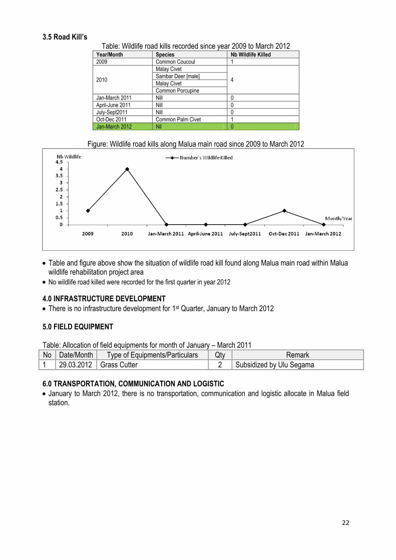
3.5 Road Kill’s Table: Wildlife road kills recorded since year 2009 to March 2012
Year/Month Species Nb Wildlife Killed
2009 Common Coucoul 1
2010
Malay Civet
4 Sambar Deer [male]
Malay Civet
Common Porcupine
Jan-March 2011 Nill 0
April-June 2011 Nill 0
July-Sept2011 Nill 0
Oct-Dec 2011 Common Palm Civet 1
Jan-March 2012 Nil 0
Figure: Wildlife road kills along Malua main road since 2009 to March 2012
Table and figure above show the situation of wildlife road kill found along Malua main road within Malua wildlife rehabilitation project area
No wildlife road killed were recorded for the first quarter in year 2012
4.0 INFRASTRUCTURE DEVELOPMENT
There is no infrastructure development for 1st Quarter, January to March 2012
5.0 FIELD EQUIPMENT
Table: Allocation of field equipments for month of January – March 2011
No Date/Month Type of Equipments/Particulars Qty Remark
1 29.03.2012 Grass Cutter 2 Subsidized by Ulu Segama
6.0 TRANSPORTATION, COMMUNICATION AND LOGISTIC
January to March 2012, there is no transportation, communication and logistic allocate in Malua field station.

23
7.0 FUEL CONSUMPTION
Table: Fuel consumption for operational field activities for month of January to March 201
Item Fuel
Month [Litter] Total Litter x RM 2.5 [RM] Jan Feb March
4 Units Vehicle
SB 7587 A
Diesel
291 413 424 1128 2820.00
SB 7589 A 335 294 118 747 1867.50
SB 9524 A 247 164 386 797 1992.50
SAA 8345 L 293 354 279 926 2315.00
Total 1166 1225 1207 3598 8995.00
4 Units Motorbike [Kawasaki]
SS 4713 N
Petrol 24 84 40 148 370 SS 4718 N
SS 4715 N
SS 4717 N
Total 24 84 40 148 370.00
Generator
MBB Station
Diesel
535 600 800 1935 4837.50
FCS 57 0 200 140 340 850.00
FCS 37 0 0 0 0 0
FCS 15 0 200 200 400 1000.00
Total 535 1000 1140 2675 6687.50
Other Machine
Grass Cutter & Chainsaw Petrol
0 24 0 24 60.00
Boat 200 199 200 599 1497.50
Total 200 223 200 623 1557.50

Annex 1
LIST OF WILDLIFE SPECIES FOUND AND RECORDED WITHIN MALUA REHABILITATION PROJECT AREA
Table 1: lists of wildlife species [mammals] recorded within Malua forest reserve since June 2009 to March 2012
No Wildlife Species (Mammals) Scientific Name Family Name
Wildlife Enc. 1997 IUCN Redlist
Sch. 1 Sch. 2 Sch. 3 CN EN VU NT DD LC
1 Orang utan √ √
2 Sumatran Rhinoceros √ √
3 Sun bear √ √
4 Borneo pygmy elephant √ √
5 Clouded leopard √ √
5 Pig-tailed macaque √ √
7 Long-tailed macaque √
8 Mouse deer √
9 Sambar deer √ √
10 Common porcupine √
11 Barking deer √
12 Wild pig √ √
13 Long-tailed porcupine √
14 Leopard cat √
15 Malay civet √
16 Malay badger √
17 Common palm civet √
18 Small-toothed palm civet √
19 Red leaf monkey √
20 Bay cat √ √
21 Marbled Cat √ √
22 Short tailed mongoose √
23 Banteng √ √
25 Binturong/Bearcat √ √
26 Sunda pangolin √ √
27 Banded palm civet √

25
28 Oriental Small-Clawed Otter √ √
29 Thomas flying squirrel √
30 Red giant flying squirrel √
31 Black flying squirrel √
32 Mongoose √
33 Thick-spined porcupine √
34 Moon Rat √
35 Common tree shrew √
36 Malaysian field rat √
37 Horse-tailed squirrel √
38 Slow loris √ √
39 Western tarsier √ √
40 Flying lemur √
41 Large flying fox √ √
42 Grey leaf monkey √
43 Bornean gibbon √ √
44 Spotted giant flying squirrel √
45 Otter civet √ √
Note:
Wildlife Enc. 1997: Schedule 1 = Totally Protected Animals, Schedule 2 = Protected Animals, Schedule 3 = Protected animals where hunting and collection is
permitted under a licence is required.
IUCN Red list: CE = Critically Endangered, EN = Endangered, VU = Vulnerable, NT = Near Threatened, LC = Less Concern, DD = Data deficient

26
Table 2: List of birds recorded within Malua forest reserve since year 2008 (compiled by: Dr. David Edwards, University of Leed, UK, Method used –
point counts and mist netting) and as well as recorded by Malua Wildlife Unit.
No Wildlife Species (Birds) Scientific Name Family Name Wildlife Enc. 1997* IUCN Redlist*
Sch.1 Sch.2 Sch.3 CE EN DD VU NT LC
1 Crested Fireback
2 Serpent Eagle
3 Oriental Darter
4 Pied Hornbill
5 Rhinoceros Hornbill √ √
6 Common Coucal
7 Chinese Egret
8 Emerald Dove
9 Great Argus
10 Purple Heron
11 Helmeted hornbill √
12 Scaly Breasted Patridge
13 Jerdon's Baza
14 Oriental Honey-Buzzard
15 Lesser Fish-Eagle
16 Crested Goshawk
17 Crested Serpent-Eagle
18 Changeable Hawk-Eagle
19 Wallace's Hawk-Eagle
20 Chestnut-necklaced Partridge
21 Great Argus
22 Crested Fireback
23 Thick-billed Green-Pigeon
24 Little Green-Pigeon
25 Green Imperial-Pigeon
26 Emerald Dove
27 Blue-rumped Parrot
28 Blue-crowned Hanging-Parrot

27
29 Banded Bay Cuckoo
30 Plaintive Cuckoo
31 Violet Cuckoo
32 Drongo Cuckoo
33 Raffles's Malkoha
34 Chestnut-breasted Malkoha
35 Short-toed Coucal
36 Greater Coucal
37 Grey-rumped Treeswift
38 Whiskered Treeswift
39 Red-naped Trogon
40 Diard's Trogon
41 Scarlet-rumped Trogon
42 Blue-banded Kingfisher
43 Oriental Dwarf Kingfisher
44 Red-bearded Bee-eater
45 Bushy-crested Hornbill
46 White-crowned Hornbill
47 Asian Black Hornbill
48 Rhinocerous Hornbill
49 Helmeted Hornbill
50 Gold-whiskered Barbet
51 Red-throated Barbet
52 Blue-eared Barbet
53 Brown Barbet
54 Rufous Piculet
55 Rufous Woodpecker
56 Buff-rumped Woodpecker
57 Buff-necked Woodpecker
58 White-bellied Woodpecker
59 Maroon Woodpecker
60 Crimson-winged Woodpecker
61 Great Slaty Woodpecker
62 Orange-backed Woodpecker

28
63 Dusky Broadbill
64 Black-and-red Broadbill
65 Banded Broadbill
66 Black-and-yellow Broadbill
67 Green Broadbill
68 Giant Pitta
69 Blue-headed Pitta
70 Black-headed Pitta
71 Black-winged Flycatcher-Shrike
72 Lesser Cuckoo-Shrike
73 Fiery Minivet
74 Scarlet Minivet
75 Green Iora
76 Lesser Green Leafbird
77 Greater Green Leafbird
78 Black-headed Bulbul
79 Puff-backed Bulbul
80 Yellow-vented Bulbul
81 Cream-vented Bulbul
82 Red-eyed Bulbul
83 Spectacled Bulbul
84 Finsch's Bulbul
85 Grey-cheeked Bulbul
86 Yellow-bellied Bulbul
87 Hairy-backed Bulbul
88 Streaked Bulbul
89 Greater Racket-tailed Drongo
90 Dark-throated Oriole
91 Asian Fairy-Bluebird
92 Crested Jay
93 Black Magpie
94 Slender-billed Crow
95 Bornean Bristlehead √
96 Black-capped Babbler

29
97 White-chested Babbler
98 Ferruginous Babbler
99 Short-tailed Babbler
100 Horsfield's Babbler
101 Moustached Babbler
102 Sooty-capped Babbler
103 Scaly-crowned Babbler
104 Rufous-crowned Babbler
105 Chestnut-backed Scimitar-Babbler
106 Bornean Wren-Babbler
107 Striped Wren-Babbler
108 Black-throated Wren-Babbler
109 Rufous-fronted Babbler
110 Grey-headed Babbler
111 Chestnut-rumped Babbler
112 Black-throated Babbler
113 Chestnut-winged Babbler
114 Bold-striped Tit-Babbler
115 Fluffy-backed Tit-Babbler
116 Brown Fulvetta
117 White-bellied Yuhina
118 White-rumped Shama
119 Rufous-tailed Shama
120 Chestnut-naped Forktail
121 White-crowned Forktail
122 Chestnut-capped Thrush
123 Dark-necked Tailorbird
124 Ashy Tailorbird
125 Rufous-tailed Tailorbird
126 Grey-chested Jungle-Flycatcher
127 Verditer
128 White-tailed Blue-flycatcher
129 Large-billed Blue-Flycatcher
130 Malaysian Blue-Flycatcher

30
131 Spotted Fantail
132 Pied Fantail
133 Black-naped Monarch
134 Maroon-breasted Philentoma
135 Rufous-winged Philentoma
136 Asian Paradise-Flycatcher
137 Hill Myna
138 Plain Sunbird
139 Red-throated Sunbird
140 Ruby-cheeked Sunbird
141 Purple-naped Sunbird
142 Purple-throated Sunbird
143 Crimson Sunbird
144 Little Spiderhunter
145 Thick-billed Spiderhunter
146 Grey-breasted Spiderhunter
147 Yellow-breasted Flowerpecker
148 Yellow-rumped Flowerpecker
149 Dusky Munia
Note:
Wildlife Enc. 1997: Schedule 1 = Totally Protected Animals, Schedule 2 = Protected Animals, Schedule 3 = Protected animals where hunting and collection is
permitted under a licence is required.
IUCN Red list: CE = Critically Endangered, EN = Endangered, VU = Vulnerable, NT = Near Threatened, LC = Less Concern, DD = Data deficient
31
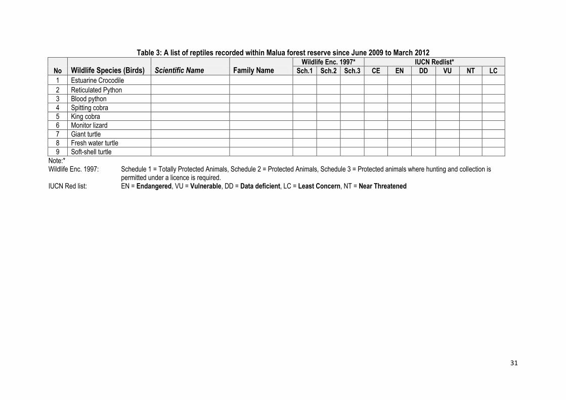
Table 3: A list of reptiles recorded within Malua forest reserve since June 2009 to March 2012
No Wildlife Species (Birds) Scientific Name Family Name Wildlife Enc. 1997* IUCN Redlist*
Sch.1 Sch.2 Sch.3 CE EN DD VU NT LC
1 Estuarine Crocodile
2 Reticulated Python
3 Blood python
4 Spitting cobra
5 King cobra
6 Monitor lizard
7 Giant turtle
8 Fresh water turtle
9 Soft-shell turtle
Note:* Wildlife Enc. 1997: Schedule 1 = Totally Protected Animals, Schedule 2 = Protected Animals, Schedule 3 = Protected animals where hunting and collection is permitted under a licence is required. IUCN Red list: EN = Endangered, VU = Vulnerable, DD = Data deficient, LC = Least Concern, NT = Near Threatened

Annex 2
Table: Adhoc /Opportunistic Wildlife Record
Date Name of Recorder Time (hrs) Weather*
Habitat Type*
GPS Location Alt (m)
Area / Cpt
Type of Sign* Species
Nb Object
Note (age, sex, food plants, tree species, etc) X_coor Y_coor
10.01.2012 Malik&Jukarmin 3:30 PM 2 1 879928 586289 34 - 1 Pied Hornbill 2
11.01.2012 Malik&Jukarmin 7:42 AM 1 1 879051 587104 10 1 Eagle (unknown) 1
11.01.2012 Malik&Jukarmin 7:44 AM 1 1 878873 586960 11 1 Pied Hornbill 1
11.01.2012 Malik&Jukarmin 7:45 AM 1 1 878875 586904 10 1 Kingfisher (unknown) 1
11.01.2012 Malik&Jukarmin 7:46 AM 1 1 878884 586791 11 1 Pied Hornbill 12
11.01.2012 Malik&Jukarmin 7:48 AM 1 1 879042 586567 12 1 Kingfisher (unknown) 2
11.01.2012 Malik&Jukarmin 7:49 AM 1 1 879086 586693 12 1 Egret (unknown) 2
11.01.2012 Malik&Jukarmin 7:52 AM 1 1 879273 586932 13 1 Eagle (unknown) 1
16.01.2012 Wildlife Team 9:39 PM 1 56 1 Malay Civet 1
16.01.2012 Wildlife Team 9:42 PM 1 56 1 Malay Civet 1
16.01.2012 Wildlife Team 9:51 PM 1 58 1 Clouded Leopard 1
17.01.2012 Wildlife Team 1 Malay Badger 1
18.01.2012 Wildlife Team 9:37 PM 1 56 1 Malay Badger 1
24.01.2012 Hadrin&Sarinus 11:13 AM 2 1 885779 565830 306 50 1 Otter 6
24.01.2012 Hadrin&Sarinus 9:25 AM 1 1 878752 562232 251 60 1 Orang Utan 5 1male, 2f, 1mother+baby
24.01.2012 Hadrin&Sarinus 9:51 AM 1 1 886003 565846 285 50 1 Orang Utan 1 flanged male
24.01.2012 Hadrin&Sarinus 9:56 AM 1 1 886893 565468 49 9 Orang Utan 2 fresh nest
24.01.2012 Hadrin&Sarinus 10:18 AM 1 1 885234 568404 271 49 1 Orang Utan 1 flanged male
24.01.2012 Hadrin&Sarinus 10:18 AM 1 1 885234 568404 271 49 1 Helmeted hornbill 1
24.01.2012 Hadrin&Sarinus 10:35 AM 1 1 883918 568073 166 84 9 Orang Utan 5 fresh nest
24.01.2012 Hadrin&Sarinus 10:44 AM 1 1 882648 568061 145 84 2/3 Banteng ++ fresh dung [many]
27.01.2012 Wildlife Team 6:58 AM 2 1 878720 562194 247 60 1 Borneo Gibbon 7
27.01.2012 Wildlife Team 7:00 AM 2 1 878720 562194 247 60 1 Orang Utan 1
27.01.2012 Wildlife Team 7:01 AM 2 1 878716 562191 243 60 1 Bushy crested hornbill 3
27.01.2012 Wildlife Team 7:17 AM 2 1 878710 562187 244 60 1 Crested fireback 1
27.01.2012 Wildlife Team 7:20 AM 2 1 878710 562187 244 60 1 Rhinoceros hornbill 1
27.01.2012 Wildlife Team 7:21 AM 2 1 878710 562187 244 60 1 Small toothed palm civet 1
27.01.2012 Wildlife Team 7:30 AM 2 1 878710 562187 244 60 1 Borneo Gibbon 2

33
27.01.2012 Wildlife Team 8:13 AM 2 1 879363 564184 116 58 1 Red leaf monkey 2
27.01.2012 Wildlife Team 8:13 AM 2 1 879363 564184 116 58 1 Borneo Gibbon 4 1 Juv, 3 Adult
27.01.2012 Wildlife Team 8:15 AM 2 1 886847 568199 251 49 1 Sambar Deer 1
28.01.2012 Wildlife Team 7:00 AM 2 878722 562208 285 56 1 Orang Utan 1 Juvenile
28.01.2012 Wildlife Team 7:30 AM 2 878722 562208 285 56 1 Bushy crested hornbill 4
14.02.2012 Rayner B 2:35 PM FCS 57 1 Red leaf monkey > 4
14.02.2012 Wildlife Team 1:45 PM 2 1 887119 565779 306 49 1 Borneo Elephant 5
18.02.2012 Rayner B 4:57 PM 52 1 Red leaf monkey > 4 20m from white house
22.02.2012 Wildlife Team 7:19 AM 1 1 885152 565628 206 50 1 Red leaf monkey 7
22.02.2012 Wildlife Team 7:34 AM 1 1 887187 565822 284 49 7 Borneo Gibbon 2
22.02.2012 Wildlife Team 7:45 AM 1 1 887489 566714 302 49 1 Borneo Gibbon 3
22.02.2012 Wildlife Team 7:45 AM 1 1 887489 566714 302 49 1 Rhinoceros hornbill 2
22.02.2012 Wildlife Team 8:40 AM 1 1 886107 568050 293 49 1 Barking Deer 1
16.03.2012 Sarinus, Davey&Fazil 11:30 AM 1 1 885156 565571 234 50 1 Sun Bear 1 Juvenile
20.03.2012 Wildlife Team 11:05 AM 2 1 879621 562932 217 58 2 Clouded Leopard fresh print
20.03.2012 Wildlife Team 11:05 AM 2 1 879621 562932 217 58 2 Mouse Deer fresh print
20.03.2012 Wildlife Team 11:58 AM 2 1 879661 562515 175 58 2 Mouse Deer fresh print
20.03.2012 Wildlife Team 12:00 PM 2 1 879676 562493 177 58 4 Rhinoceros hornbill calling
20.03.2012 Wildlife Team 12:05 PM 2 1 879668 562579 170 58 2 Banteng fresh print
21.03.2012 Wildlife Team 10:00 AM 2 1 881009 566631 122 52 1 Rhinoceros hornbill 3 1 juvenile
21.03.2012 Wildlife Team 10:00 AM 2 1 881009 566631 122 52 4 Helmeted hornbill 1 calling
23.03.2012 Wildlife Team 8:06 PM 1 1 880834 565556 83 52 1 Sun Bear 2 1 juvenile
25.03.2012 Wildlife Team 11:39 AM 1 1 881735 587621 91 15 1 Bushy crested hornbill >5
27.03.2012 Wildlife Team 6:27 AM 1 1 878626 562111 268 62 1 Borneo Gibbon 3
27.03.2012 Wildlife Team 6:35 AM 1 1 878637 562119 258 62 1 Rhinoceros hornbill 2
27.03.2012 Wildlife Team 6:51 AM 1 1 878763 562236 248 60 1 Borneo Gibbon 5
05.04.2012 Rayner&Merril 5:58 PM 2 1 52 1 Sambar deer 1 male, 200m from white house
06.04.2012 Merril Halley 7:30 AM
52 1 Red leaf monkey 3 south of the stream and west of the old bridge from rumah putih
06.04.2012 Merril Halley 7:30 AM
52 1 Long-tailed macaque 6
adult LTM along the south side of the stream east of the old bridge
08.04.2012 Rayner B 7:55 AM 1 1
52 1 Pied Hornbill 1 30m from office, calling and resting
08.04.2012 Rayner B 11:15 AM 1 1 45 1 Long-tailed macaque > 1 near to bridge collapse in cpt 45
19.04.2012 Rayner B 9:40 AM 1 1 FCS 15 1 Helmeted Hornbill 1 on the tree: resting and calling
Note *:

34
Habitat Type*: 1- Lowland (< 500m), 2- Upland (>500m), 3- Dry Lowland, 4- Open Area, 5- Semi Inundated, 6- Swamp, 7- River, 8- Riparian Slope: 1: Flat, 2: 0-10°, 3: 10°-45°, 4: >45°, 5: Top Ridge , 6: Undulating Weather: 1- Clear, 2- Cloudy, 3- Heavy Rain, 4-Drizzling Type of Sign*: 1- Direct Sighting, 2- footprint, 3- dung, 4- Calling, 5- Feeding Sign, 7- Claw Mark, 8- Mud Rubbing, 9- Urine, 10- Wallow, 11- Twisted, 12- Nest

Annex 3
Orang Utan Nest Count Datasheet [New Nest]
9th Survey: North Malua - CPT15&16/Omar Transect), 31st Dec 2011, Dist = 1110m, bearing 90 nest no dist on
transect nest height [m] nest
class PD [m] bearingo slopeo Tree species
1 ? 10/20 1 30 180 laran
2 150 10/20 3 15.7 180 bayur
3 150 10/20 3 15.7 180 bayur
4 250 10/20 4 18.7 360 laran
5 260 10/20 3 22.4 360 laran
6 260 10/20 3 25.1 360 laran
7 320 10/20 2 13.7 180 sedaman
8 395 10/20 1 12.3 180 bayur
9 410 10/20 3 0.1 180 ?
10 490 10/20 3 24.7 180 sedaman
11 505 10/20 3 30 360 laran
12 550 10/20 4 15.7 360 laran
13 630 10/20 3 30 180 laran
14 680 10/20 3 15.7 360 keruing
15 686 10/20 3 28.9 180 laran
16 690 10/20 3 24.1 360 laran
17 750 10/20 4 17.7 180 laran
18 820 10/20 1 10.4 180 kungkurad
19 820 10/20 3 10.5 180 laran
20 820 10/20 3 16 180 kungkurad
21 895 10/20 3 0.1 180 urat mata
22 900 10/20 3 12.4 180 laran
23 910 10/20 3 12.6 180 laran
23 402.5
∑PD = 402.5 ∑nest = 23 Dist = 1.1km Outlier = nil W1 [∑PD/∑nest]= 17.5 n = 13 Dnest = n/2W*L [North Malua, 9th Survey] 13/2(17.5m)*1.1km Dnest = n/ (2W * L) 13/(35m*1.1km) 13/(0.035km*1.1km) 337.66 Dnest = 337.66nest/km² OU Density [Dnest/[PRT] = 8.472908

36
9th Survey: South Malua (b) - CPT58, 26th Dec 2011, Dist = 1330m, bearing 180 nest no dist on transect [m] nest height [m]
nest class PD [m] bearing slope Tree species
1 125 10/20 1 20.3 90 laran
2 245 10/20 5 22.1 90 laran
3 300 10/20 3 7.5 90 laran
4 300 10/20 5 7.5 90 laran
5 330 10/20 4 7 270 seraya
6 330 10/20 3 15.3 90 laran
7 362 10/20 3 10 270 10 magas
8 370 10/20 3 4.3 270 kedondong
9 400 10/20 4 18.7 270 20 laran
10 400 10/20 3 25.7 270 20 laran
11 500 10/20 3 17.1 90 laran
12 500 10/20 1 17.8 90 laran
13 560 10/20 4 6.8 270 unknown
14 590 10/20 4 0.1 90 belian
15 850 10/20 3 24.9 270 kungkurad
15 205.1
9th Survey: South Malua (b) - CPT52, 26th Dec 2011, Dist = 1310m, bearing 360 nest no dist on transect [m] nest height [m]
nest class PD [m] bearing slope Tree species
1 360 10/20 3 24.7 90 laran
2 360 10/20 3 28.1 90 bayur
3 580 10/20 3 0.1 90 lantupak
4 580 10/20 3 0.1 90 lantupak
5 700 10/20 3 6 270 bayur
5 59
∑nest [south a + b) = 20 ∑PD [South a+b) = 264.1 13.205 W1 = 13.205m Outlier = nil Dist = 2.64km n = 10 Dnest = n/2W*L [South Malua, 9th Survey] 10/2(13.205m) * 2.64km 10/26.41m*2.64km 10/0.02641km*2.64km 143.43 Dnest = 143.43nest/km² OU Density [Dnest/[PRT] = 3.513275

37
9th Survey: SBE - A (Compartment 85), 28th Dec 2011, Dist 420m, Bearing 180° Nest no Dist on Transect [m] Nest Height [m]
Nest Class
PD [m] Bearing Slope Tree Species
Note: No new nest found - heavy rain, covered only 420m of distance
9th Survey: SBE - B (Compartment 85), 28th Dec 2011, Dist 1000m, Bearing 180° Nest no Dist on Transect
[m] Nest Height (m) Nest
Class PD [m]
Bearingo Slopeo Tree Species
1 ? 10/20 3 12.7 90 seraya
2 180 10/20 1 12.7 90 seraya
3 180 10/20 3 13.7 90 laran
4 195 10/20 3 15.7 90 laran
5 205 10/20 3 13.8 270 bulu-bulu
6 250 10/20 3 25.7 90 bulu-bulu
7 275 10/20 3 5 270 bulu-bulu
8 300 10/20 4 8.9 90 unknown
9 ? 10/20 3 13.4 90 ?
10 430 10/20 4 15.3 270 sedaman telinga gajah
11 460 10/20 3 12.7 270 bulu-bulu
12 470 10/20 4 28.7 90 laran
13 485 10/20 3 28.9 90 laran
14 540 10/20 3 15.4 90 laran
15 560 10/20 3 25.8 90 laran
15 248.4 ∑PD = 248.4 ∑nest = 15 Dist = 1420m Outlier = nil W1 [∑PD/∑nest]= 16.56 n = 11 Dnest = n/2W*L [SBE, 9th Survey] 11/2(16.56m)*1.42km Dnest = n/ (2W * L) 11/33.12m*1.42km 11/(0.03312km*1.42km) Dnest 233.89 Dnest = 233.89 nest / km² OU Densities (Dnest/PRT) = 5.7293
38
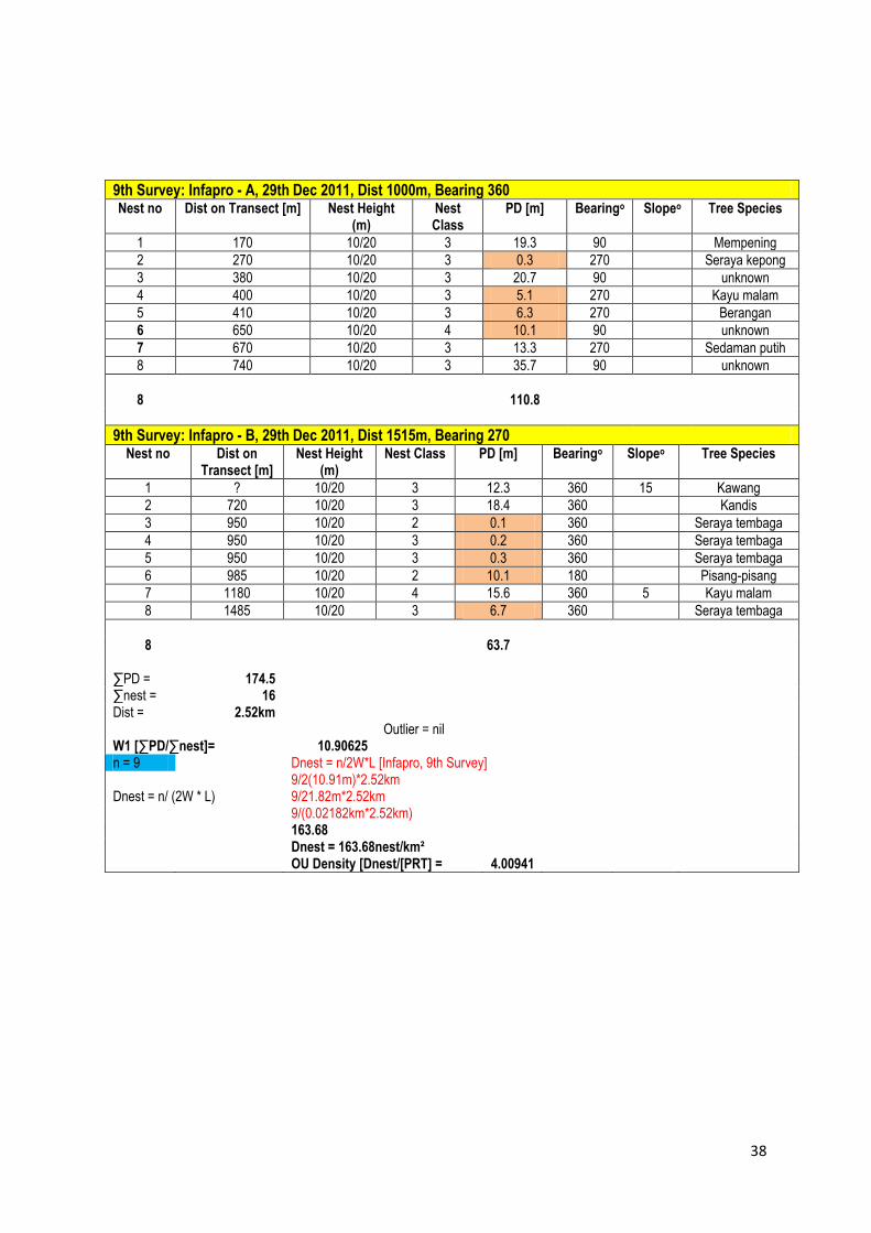
9th Survey: Infapro - A, 29th Dec 2011, Dist 1000m, Bearing 360 Nest no Dist on Transect [m] Nest Height
(m) Nest Class
PD [m] Bearingo Slopeo Tree Species
1 170 10/20 3 19.3 90 Mempening
2 270 10/20 3 0.3 270 Seraya kepong
3 380 10/20 3 20.7 90 unknown
4 400 10/20 3 5.1 270 Kayu malam
5 410 10/20 3 6.3 270 Berangan
6 650 10/20 4 10.1 90 unknown
7 670 10/20 3 13.3 270 Sedaman putih
8 740 10/20 3 35.7 90 unknown
8 110.8
9th Survey: Infapro - B, 29th Dec 2011, Dist 1515m, Bearing 270 Nest no Dist on
Transect [m] Nest Height
(m) Nest Class PD [m] Bearingo Slopeo Tree Species
1 ? 10/20 3 12.3 360 15 Kawang
2 720 10/20 3 18.4 360 Kandis
3 950 10/20 2 0.1 360 Seraya tembaga
4 950 10/20 3 0.2 360 Seraya tembaga
5 950 10/20 3 0.3 360 Seraya tembaga
6 985 10/20 2 10.1 180 Pisang-pisang
7 1180 10/20 4 15.6 360 5 Kayu malam
8 1485 10/20 3 6.7 360 Seraya tembaga
8 63.7
∑PD = 174.5 ∑nest = 16 Dist = 2.52km Outlier = nil W1 [∑PD/∑nest]= 10.90625 n = 9 Dnest = n/2W*L [Infapro, 9th Survey] 9/2(10.91m)*2.52km Dnest = n/ (2W * L) 9/21.82m*2.52km 9/(0.02182km*2.52km) 163.68 Dnest = 163.68nest/km² OU Density [Dnest/[PRT] = 4.00941

39
10th Survey: South Malua (a) - CPT58, 06th Feb 2012, Dist = 2000m, bearing 180 nest no dist on transect [m] nest height [m]
nest class PD [m]
bearing slope Tree species
1 640 20/30 3 2.1 90 majau
2 790 20/30 4 20 270 laran
3 1090 10/20 1 17.1 270 kedondong
4 1095 20/30 1 14 270 laran
5 1240 10/20 5 8.9 90 kedondong
6 1270 10/20 3 4.7 90 sedaman
7 1345 20/30 4 28 270 laran
8 1345 20/30 3 29 270 laran
9 1410 20/30 4 28 270 seraya
10 1520 20/30 4 19 270 seraya
11 1530 10/20 1 16 270 kedondong
12 1590 10/20 3 0.1 90 keruing
13 1605 20/30 3 30 270 laran
14 1660 10/20 3 6.1 90 sedaman telinga gajah
15 1710 20/30 4 11 90 laran
16 1750 20/30 5 30 270 laran
17 1750 20/30 4 29 270 laran
18 1750 20/30 5 27 270 laran
19 1755 20/30 3 13 270 laran
20 1755 20/30 4 1 90 laran
21 1977 20/30 4 25 270 laran
21 359
10th Survey: South Malua (b) - CPT52, 07th Feb 2012, Dist = 2000m, bearing 360 nest no dist on transect [m] nest height [m]
nest class PD [m]
bearing slope Tree species
1 605 20/30 1 20 270 bayur
2 750 10/20 3 16 270 bayur
3 1385 10/20 2 7.4 90 ?
4 1400 20/30 3 18.6 90 laran
5 1405 20/30 3 24 90 keruing
5 86
∑nest [south a + b)
= 26 ∑PD [South a+b) = 445 17.11
5
W1 = 17.12m Outlier = nil Dist = 4km n = 13 Dnest = n/2W*L [South Malua, 10th Survey] 13/2(17.12m) * 4km 13/34.24m*4km 13/0.03424km*4km 94.92 Dnest = 94.92nest/km² OU Density [Dnest/[PRT] = 2.2709
9

40
10th Survey: North Malua - CPT15&16/Omar Transect), 11th Feb 2012, Dist = 1170m, bearing 90 nest no dist on transect nest height [m] nest class PD [m] bearingo slopeo Tree species
1 200 10/20 3 5.7 180 magas
2 410 10/20 4 18.1 180 laran
3 620 10/20 4 10.8 360 laran
4 740 20/30 4 30 180 laran
5 750 10/20 3 29.9 180 laran
6 900 20/30 4 8.4 180 laran
7 905 10/20 1 4.9 180 sedaman
8 950 10/20 3 28.1 180 laran
9 1110 10/20 4 18.1 180 laran
9 154
∑PD = 154 ∑nest = 9 Dist = 1.17km Outlier = nil W1 [∑PD/∑nest]= 17.11111111 n = 4 Dnest = n/2W*L [North Malua, 10th Survey] 4/2(17.11m)*1.17km Dnest = n/ (2W * L) 4/(34.22m*1.17km) 4/(0.03422km*1.17km) 99.91 Dnest = 99.91nest/km² OU Density [Dnest/[PRT] = 2.39034
41
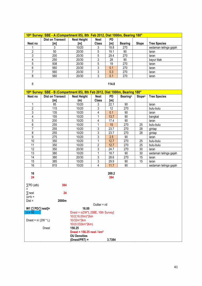
10th Survey: SBE - A (Compartment 85), 8th Feb 2012, Dist 1000m, Bearing 180°
Nest no Dist on Transect
[m] Nest Height
[m] Nest Class
PD [m] Bearing Slope Tree Species
1 3 10/20 3 18.8 270 sedaman telinga gajah
2 50 20/30 5 19.1 90 laran
3 200 20/30 5 29.4 270 laran
4 250 20/30 3 28 90 bayur litak
5 508 20/30 5 19 270 laran
6 560 20/30 3 0.1 270 laran
7 560 20/30 3 0.3 270 laran
8 560 20/30 3 0.1 270 laran
8 114.8
10th Survey: SBE - B (Compartment 85), 8th Feb 2012, Dist 1000m, Bearing 180° Nest no Dist on Transect
[m] Nest Height
(m) Nest Class
PD [m]
Bearingo Slopeo Tree Species
1 85 10/20 3 22.1 90 laran
2 115 10/20 3 12 270 bulu-bulu
3 135 10/20 4 0.1 90 laran
4 155 10/20 1 13.7 90 bangkal
5 200 10/20 4 17.4 90 laran
6 255 10/20 1 15 270 25 bulu-bulu
7 255 10/20 3 23.7 270 28 gintap
8 255 10/20 3 23.7 270 28 gintap
9 275 10/20 3 2.5 90 laran
10 350 10/20 1 12.7 270 25 bulu-bulu
11 350 10/20 2 12.7 270 25 bulu-bulu
12 350 20/30 3 24.7 270 30 laran
13 380 10/20 1 18.7 90 30 sedaman telinga gajah
14 380 20/30 3 28.6 270 15 laran
15 385 10/20 3 29.9 90 15 laran
16 815 10/20 4 11.7 90 sedaman telinga gajah
16 269.2 24 384
∑PD (atb) =
384
∑nest (a+b =
24
Dist = 2000m Outlier = nil W1 [∑PD/∑nest]= 16.00 n = 10 Dnest = n/2W*L [SBE, 10th Survey] 10/2(16.00m)*2km Dnest = n/ (2W * L) 10/32m*2km 10/(0.032km*2km) Dnest 156.25 Dnest = 156.25 nest / km²
OU Densities (Dnest/PRT) = 3.7384

42
10th Survey: Infapro - A, 9th Feb 2012, Dist 1000m, Bearing 360 Nest no
Dist on Transect [m] Nest Height (m) Nest Class
PD [m]
Bearingo Slopeo Tree Species
1 125 10/20 4 20.5 90 magas
2 260 10/20 2 21.3 90 seraya minyak
3 260 20/30 3 25 90 sedaman
4 380 10/20 3 28 270 seraya putih
5 400 10/20 4 5.1 90 kayu malam
6 680 10/20 4 0.2 90 laran
6 100.1
10th Survey: Infapro - B, 9th Feb 2012, Dist 2000m, Bearing 270 Nest no
Dist on Transect [m] Nest Height (m) Nest Class
PD [m]
Bearingo Slopeo Tree Species
1 150 10/20 3 15.7 360 mempening
2 200 10/20 3 15.4 180 medang
3 215 10/20 3 15.7 180 kungkurad
4 315 10/20 1 19.7 180 sedaman
5 315 10/20 3 17.4 360 ?
6 320 10/20 3 17.4 360 sedaman
7 690 20/30 3 1.4 180 rawang
8 700 10/20 3 27.5 180 seraya minyak
9 940 10/20 4 13.9 180 sedaman telinga gajah
10 1060 10/20 3 13 360 mempening
11 1345 10/20 1 17.2 360 kungkurad
12 1715 10/20 2 27.1 180 tangkol
13 1720 10/20 3 13 360 ?
14 1765 10/20 2 3.5 180 ?
15 1835 10/20 3 12.7 360 seraya
15 230.6
∑PD = 330.7 ∑nest =
21
Dist = 3km Outlier = nil W1 [∑PD/∑nest]= 15.74761905 n = 11 Dnest = n/2W*L [Infapro, 10th Survey] 11/2(15.75m)*3km Dnest = n/ (2W * L) 11/31.5m*3km 11/(0.0315km*3km) 116.40 Dnest = 116.40nest/km² OU Density [Dnest/[PRT] = 2.785

43
11th Survey: South Malua (a) - CPT58, 20th March 2012, Dist = 2000m, bearing 180 nest no dist on transect [m] nest height [m]
nest class
PD [m] bearing slope Tree species
1 160 10/20 3 15.4 bayur
2 210 20/30 3 0.1 bayur
3 290 20/30 3 4.7 laran
4 510 10/20 3 18.4 urat mata beludu
5 1250 20/30 3 7.8 laran
6 1465 10/20 3 13.7 kungkurad
7 1465 10/20 3 13.7 kungkurad
8 1510 20/30 3 11.1 sedaman
9 1530 10/20 3 0.1 kayu malam
9 85
11th Survey: South Malua (b) - CPT52, 21th March 2012, Dist = 1500m, bearing 360 nest no dist on transect [m] nest height [m]
nest class
PD [m] bearing slope Tree species
1 365 20/30 4 16.8 90 laran
1 16.8
∑nest [south a + b) = 10 ∑PD [South a+b) = 101.8 10.180 W1 = 10.18m Outlier = nil Dist = 3.5km n = 4 Dnest = n/2W*L [South Malua, 11th Survey] 4/2(10.18m) *3.5km 4/20.36m*3.5km 4/0.02036km*3.5km 56.13 Dnest = 56.13nest/km² OU Density [Dnest/[PRT] = 1.343

44
11th Survey: North Malua - CPT15&16/Omar Transect), 25th March 2012, Dist = 2000m, bearing 90 nest no dist on transect nest height [m] nest
class PD [m] bearingo slopeo Tree species
1 0 20/30 3 30 180 laran
2 395 20/30 1 12.3 180 bayur
3 395 20/30 2 12.3 180 bayur
4 400 10/20 1 12.3 180 seraya
5 555 20/30 3 28 360 bayur
6 820 20/30 4 24 180 laran
7 1530 20/30 3 12 180 bayur
8 1800 10/20 3 5 180 laran
9 1850 20/30 3 6.5 180 urat mata
10 1850 20/30 5 6.5 180 urat mata
11 1940 20/30 3 13.4 180 takalis daun halus
12 1940 20/30 3 13.4 180 takalis daun halus
13 1940 0/20 3 12.8 180 takalis daun halus
13 188.5
∑PD = 188.5 ∑nest = 13 Dist = 2km Outlier = nil W1 [∑PD/∑nest]= 14.5 n = 10 Dnest = n/2W*L [North Malua, 11th Survey] 10/2(14.5m)*2km Dnest = n/ (2W * L) 10/(29m*2km) 10/(0.029km*2km) 172.41 Dnest = 172.41nest/km² OU Density [Dnest/[PRT] = 4.1251

45
11th Survey: SBE - A (Compartment 85), 22nd March 2012, Dist 0m, Bearing 180°
Nest no Dist on Transect
[m] Nest Height
[m] Nest Class PD [m] Bearing Slope Tree Species
0
SBE - B (Compartment 85), 22nd March 2012, Dist 1000m, Bearing 180°
Nest no Dist on Transect [m]
Nest Height (m)
Nest Class
PD [m] Bearingo Slopeo Tree Species
1 24 10/20 3 0.5
2 24 20/30 4 6.7
3 100 10/20 3 0.1
4 200 0/10 3 14.7
5 248 20/30 3 27.6
6 385 20/30 4 29.9
7 455 10/20 4 5.6
7 85.1 7 85.1
∑PD (atb) = 85.1 ∑nest (a+b = 7 Dist = 1000m Outlier = nil W1 [∑PD/∑nest]= 12.16 n = 4 Dnest = n/2W*L [SBE, 11th Survey] 4/2(12.16m)*1km Dnest = n/ (2W * L) 4/24.32m*1km 4/(0.02432km*1km) Dnest 164.47 Dnest = 164.47 nest / km²
OU Densities (Dnest/PRT) = 3.9352

46
11th Survey: Infapro - A, 23rd March 2012, Dist 1000m, Bearing 360 Nest no
Dist on Transect [m]
Nest Height (m) Nest Class
PD [m]
Bearingo Slopeo Tree Species
1 25 0/10 3 7 90 dara-dara
2 55 20/30 3 17.8 90 laran
3 255 10/20 3 7.8 270 membuakat
4 410 20/30 2 6.3 270 berangan
5 510 20/30 3 27.8 90 laran
6 515 10/20 1 10.1 270 kerai hitam
7 525 20/30 3 11.5 270 kawang
8 550 10/20 1 11.3 270 kayu malam
9 675 20/30 3 2.8 270 seraya punai
10 700 20/30 2 17.4 270 kawang
11 820 10/20 3 22.1 270 bulu-bulu
12 840 20/30 3 17.8 90 unknown
13 840 10/20 3 29.8 90 seraya minyak
13 189.5
11th Survey: Infapro - B, 23rd March 2012, Dist 2000m, Bearing 270 Nest no
Dist on Transect [m]
Nest Height (m) Nest Class
PD [m]
Bearingo Slopeo Tree Species
1 100 0/10 4 12 180 10 mellotus
2 585 10/20 4 10.9 360 kendolon
3 685 10/20 2 1.8 360 kungkurad
4 800 20/30 3 4.7 360 sedaman telinga gajah
5 810 20/30 3 10.9 180 unknown
6 1000 10/30 3 5 360 seraya minyak
7 1000 10/20 3 10 180 rasak
8 1200 20/30 3 0.1 180 kasai
15 55.4
∑PD = 244.9 ∑nest = 28 Dist = 3km Outlier = nil W1 [∑PD/∑nest]= 8.746428571 n = 8 Dnest = n/2W*L [Infapro, 11th Survey] 8/2(8.75m)*3km Dnest = n/ (2W * L) 8/17.5m*3km 8/(0.0175km*3km) 152.38 Dnest = 152.38nest/km² OU Density [Dnest/[PRT] = 3.646

47

48
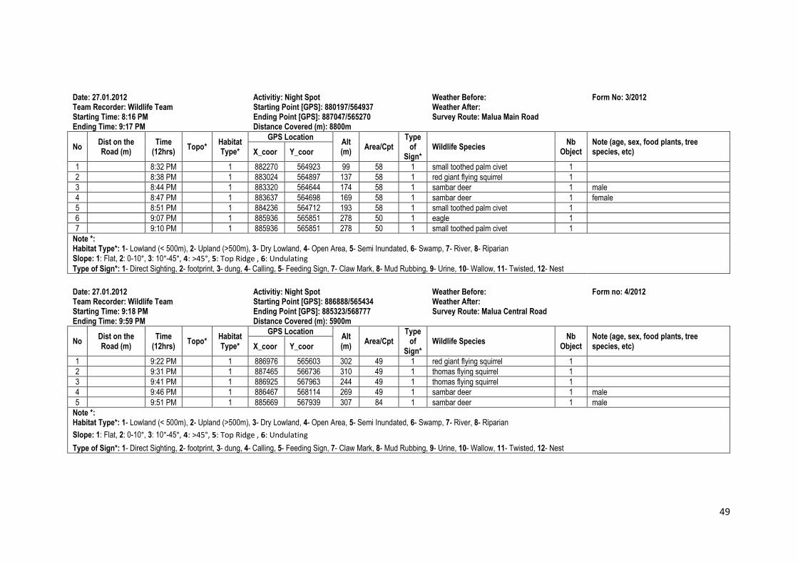
Annex 4
Date: 18.01.2012 Activitiy: Night Spot Weather Before: Form: 1/2012 Team Recorder: Wildlife Team Starting Point [GPS]: 880194/564935 Weather After: Starting Time: 8:27 PM Ending Point [GPS]: 887052/565266 Survey Route: Malua Main Road Ending Time: 9:08 PM Distance Covered (m): 8700m
No Dist on the Road (m)
Time (12hrs)
Topo* Habitat Type*
GPS Location Alt (m)
Area/Cpt Type
of Sign*
Wildlife Species Nb
Object Note (age, sex, food plants, tree species, etc) X_coor Y_coor
1 8:38 PM 2 882391 564892 108 85 1 small toothed palm civet 1
2 8:48 PM 2 884358 564733 191 85 1 small toothed palm civet 1
3 8:57 PM 2 886184 565860 279 50 1 red giant flying squirrel 1
4 9:01 PM 2 886298 565625 279 50 1 small toothed palm civet 1
5 9:06 PM 2 886971 565349 295 49 1 leopard cat 1
Note *: Habitat Type*: 1- Lowland (< 500m), 2- Upland (>500m), 3- Dry Lowland, 4- Open Area, 5- Semi Inundated, 6- Swamp, 7- River, 8- Riparian Slope: 1: Flat, 2: 0-10°, 3: 10°-45°, 4: >45°, 5: Top Ridge , 6: Undulating
Type of Sign*: 1- Direct Sighting, 2- footprint, 3- dung, 4- Calling, 5- Feeding Sign, 7- Claw Mark, 8- Mud Rubbing, 9- Urine, 10- Wallow, 11- Twisted, 12- Nest
Date: 18.01.2012 Activitiy: Night Spot Weather Before: Form: 2/2012 Team Recorder: Wildlife Team Starting Point [GPS]: 886890/565430 Weather After: Starting Time: 9:09 PM Ending Point [GPS]: 885323/568785 Survey Route: Malua Central Road Ending Time: 10:05 PM Distance Covered (m): 5900m
No Dist on the Road
(m) Time
(12hrs) Topo*
Habitat Type*
GPS Location Alt (m) Area/Cpt
Type of
Sign* Wildlife Species
Nb Object
Note (age, sex, food plants, tree species, etc) X_coor Y_coor
1 9:19 PM 2 887356 566340 299 49 1 thomas flying squirrel 2
Note *: Habitat Type*: 1- Lowland (< 500m), 2- Upland (>500m), 3- Dry Lowland, 4- Open Area, 5- Semi Inundated, 6- Swamp, 7- River, 8- Riparian Slope: 1: Flat, 2: 0-10°, 3: 10°-45°, 4: >45°, 5: Top Ridge , 6: Undulating
Type of Sign*: 1- Direct Sighting, 2- footprint, 3- dung, 4- Calling, 5- Feeding Sign, 7- Claw Mark, 8- Mud Rubbing, 9- Urine, 10- Wallow, 11- Twisted, 12- Nest
49
Date: 27.01.2012 Activitiy: Night Spot Weather Before: Form No: 3/2012 Team Recorder: Wildlife Team Starting Point [GPS]: 880197/564937 Weather After: Starting Time: 8:16 PM Ending Point [GPS]: 887047/565270 Survey Route: Malua Main Road Ending Time: 9:17 PM Distance Covered (m): 8800m
No Dist on the Road (m)
Time (12hrs)
Topo* Habitat Type*
GPS Location Alt (m)
Area/Cpt Type
of Sign*
Wildlife Species Nb
Object Note (age, sex, food plants, tree species, etc) X_coor Y_coor
1 8:32 PM 1 882270 564923 99 58 1 small toothed palm civet 1
2 8:38 PM 1 883024 564897 137 58 1 red giant flying squirrel 1
3 8:44 PM 1 883320 564644 174 58 1 sambar deer 1 male
4 8:47 PM 1 883637 564698 169 58 1 sambar deer 1 female
5 8:51 PM 1 884236 564712 193 58 1 small toothed palm civet 1
6 9:07 PM 1 885936 565851 278 50 1 eagle 1
7 9:10 PM 1 885936 565851 278 50 1 small toothed palm civet 1
Note *: Habitat Type*: 1- Lowland (< 500m), 2- Upland (>500m), 3- Dry Lowland, 4- Open Area, 5- Semi Inundated, 6- Swamp, 7- River, 8- Riparian Slope: 1: Flat, 2: 0-10°, 3: 10°-45°, 4: >45°, 5: Top Ridge , 6: Undulating
Type of Sign*: 1- Direct Sighting, 2- footprint, 3- dung, 4- Calling, 5- Feeding Sign, 7- Claw Mark, 8- Mud Rubbing, 9- Urine, 10- Wallow, 11- Twisted, 12- Nest
Date: 27.01.2012 Activitiy: Night Spot Weather Before: Form no: 4/2012 Team Recorder: Wildlife Team Starting Point [GPS]: 886888/565434 Weather After: Starting Time: 9:18 PM Ending Point [GPS]: 885323/568777 Survey Route: Malua Central Road Ending Time: 9:59 PM Distance Covered (m): 5900m
No Dist on the Road (m)
Time (12hrs)
Topo* Habitat Type*
GPS Location Alt (m)
Area/Cpt Type
of Sign*
Wildlife Species Nb
Object Note (age, sex, food plants, tree species, etc) X_coor Y_coor
1 9:22 PM 1 886976 565603 302 49 1 red giant flying squirrel 1
2 9:31 PM 1 887465 566736 310 49 1 thomas flying squirrel 1
3 9:41 PM 1 886925 567963 244 49 1 thomas flying squirrel 1
4 9:46 PM 1 886467 568114 269 49 1 sambar deer 1 male
5 9:51 PM 1 885669 567939 307 84 1 sambar deer 1 male
Note *: Habitat Type*: 1- Lowland (< 500m), 2- Upland (>500m), 3- Dry Lowland, 4- Open Area, 5- Semi Inundated, 6- Swamp, 7- River, 8- Riparian
Slope: 1: Flat, 2: 0-10°, 3: 10°-45°, 4: >45°, 5: Top Ridge , 6: Undulating
Type of Sign*: 1- Direct Sighting, 2- footprint, 3- dung, 4- Calling, 5- Feeding Sign, 7- Claw Mark, 8- Mud Rubbing, 9- Urine, 10- Wallow, 11- Twisted, 12- Nest
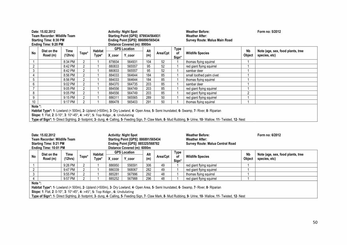
50
Date: 15.02.2012 Activitiy: Night Spot Weather Before: Form no: 5/2012 Team Recorder: Wildlife Team Starting Point [GPS]: 879934/564931 Weather After: Starting Time: 8:30 PM Ending Point [GPS]: 886890/565434 Survey Route: Malua Main Road Ending Time: 9:20 PM Distance Covered (m): 8900m
No Dist on the Road (m)
Time (12hrs)
Topo* Habitat Type*
GPS Location Alt (m)
Area/Cpt Type
of Sign*
Wildlife Species Nb
Object Note (age, sex, food plants, tree species, etc) X_coor Y_coor
1 8:34 PM 2 1 879934 564931 104 52 1 thomas flying squirrel 1
2 8:42 PM 2 1 880833 565557 95 52 1 red giant flying squirrel 1
3 8:42 PM 2 1 880833 565557 95 52 1 sambar deer 1
4 8:56 PM 2 1 884033 564644 184 85 1 small toothed palm civet 1
5 8:56 PM 2 1 884033 564644 184 85 1 thomas flying squirrel 1
6 9:02 PM 2 1 884370 564735 203 85 1 sambar deer 1
7 9:05 PM 2 1 884556 564749 203 85 1 red giant flying squirrel 1
8 9:05 PM 2 1 884556 564749 203 85 1 red giant flying squirrel 2
9 9:15 PM 2 1 886311 565565 289 50 1 red giant flying squirrel 1
10 9:17 PM 2 1 886478 565403 291 50 1 thomas flying squirrel 1
Note *: Habitat Type*: 1- Lowland (< 500m), 2- Upland (>500m), 3- Dry Lowland, 4- Open Area, 5- Semi Inundated, 6- Swamp, 7- River, 8- Riparian Slope: 1: Flat, 2: 0-10°, 3: 10°-45°, 4: >45°, 5: Top Ridge , 6: Undulating
Type of Sign*: 1- Direct Sighting, 2- footprint, 3- dung, 4- Calling, 5- Feeding Sign, 7- Claw Mark, 8- Mud Rubbing, 9- Urine, 10- Wallow, 11- Twisted, 12- Nest
Date: 15.02.2012 Activitiy: Night Spot Weather Before: Form no: 6/2012 Team Recorder: Wildlife Team Starting Point [GPS]: 886891/565434 Weather After: Starting Time: 9:21 PM Ending Point [GPS]: 885325/568782 Survey Route: Malua Central Road Ending Time: 10:01 PM Distance Covered (m): 6000m
No Dist on the Road (m)
Time (12hrs)
Topo* Habitat Type*
GPS Location Alt (m)
Area/Cpt Type
of Sign*
Wildlife Species Nb
Object Note (age, sex, food plants, tree species, etc) X_coor Y_coor
1 9:26 PM 2 1 886950 556591 306 49 1 red giant flying squirrel 1
2 9:47 PM 2 1 886339 568067 282 49 1 red giant flying squirrel 1
3 9:55 PM 2 1 885281 567996 292 48 1 thomas flying squirrel 1
4 9:57 PM 2 1 885252 567988 296 48 1 red giant flying squirrel 1
Note *: Habitat Type*: 1- Lowland (< 500m), 2- Upland (>500m), 3- Dry Lowland, 4- Open Area, 5- Semi Inundated, 6- Swamp, 7- River, 8- Riparian Slope: 1: Flat, 2: 0-10°, 3: 10°-45°, 4: >45°, 5: Top Ridge , 6: Undulating
Type of Sign*: 1- Direct Sighting, 2- footprint, 3- dung, 4- Calling, 5- Feeding Sign, 7- Claw Mark, 8- Mud Rubbing, 9- Urine, 10- Wallow, 11- Twisted, 12- Nest
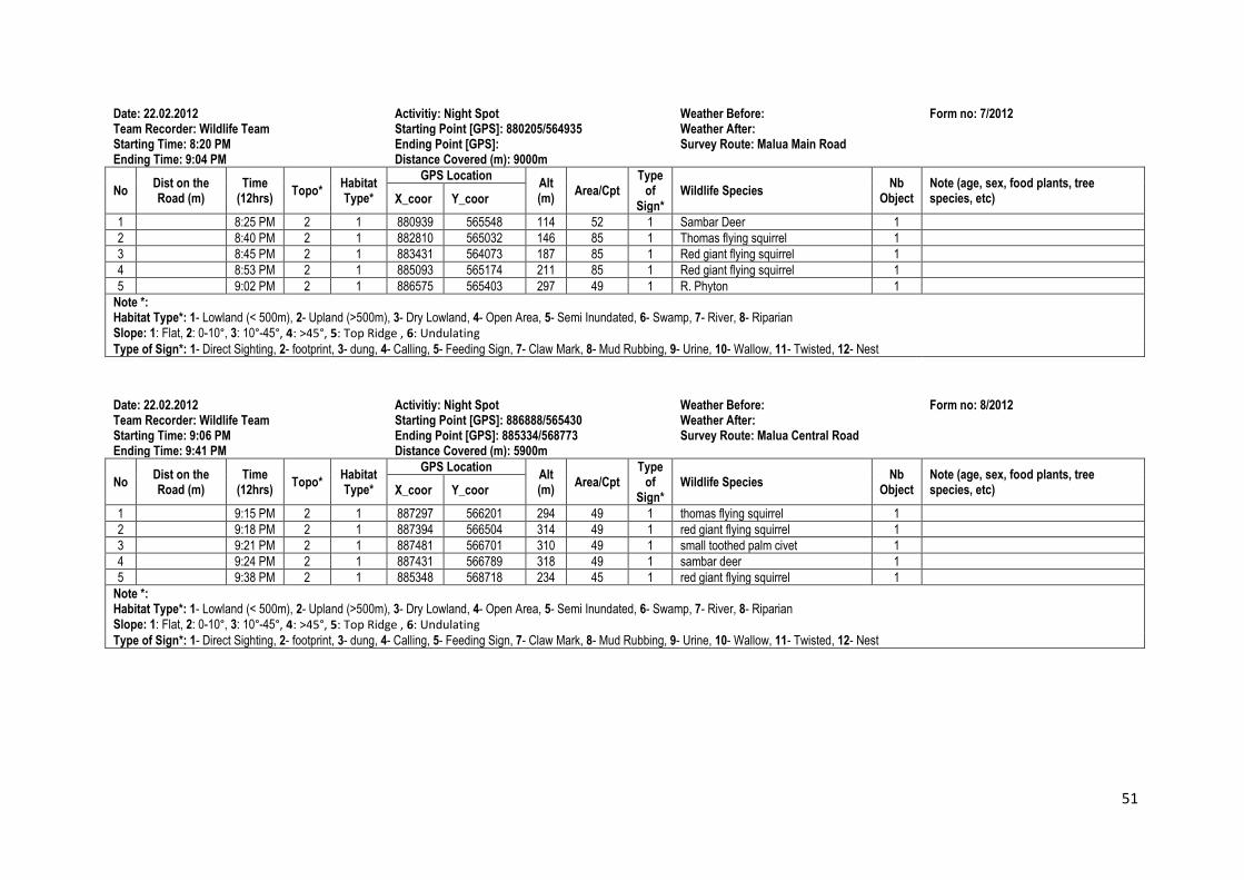
51
Date: 22.02.2012 Activitiy: Night Spot Weather Before: Form no: 7/2012 Team Recorder: Wildlife Team Starting Point [GPS]: 880205/564935 Weather After: Starting Time: 8:20 PM Ending Point [GPS]: Survey Route: Malua Main Road Ending Time: 9:04 PM Distance Covered (m): 9000m
No Dist on the Road (m)
Time (12hrs)
Topo* Habitat Type*
GPS Location Alt (m)
Area/Cpt Type
of Sign*
Wildlife Species Nb
Object Note (age, sex, food plants, tree species, etc) X_coor Y_coor
1 8:25 PM 2 1 880939 565548 114 52 1 Sambar Deer 1
2 8:40 PM 2 1 882810 565032 146 85 1 Thomas flying squirrel 1
3 8:45 PM 2 1 883431 564073 187 85 1 Red giant flying squirrel 1
4 8:53 PM 2 1 885093 565174 211 85 1 Red giant flying squirrel 1
5 9:02 PM 2 1 886575 565403 297 49 1 R. Phyton 1
Note *: Habitat Type*: 1- Lowland (< 500m), 2- Upland (>500m), 3- Dry Lowland, 4- Open Area, 5- Semi Inundated, 6- Swamp, 7- River, 8- Riparian Slope: 1: Flat, 2: 0-10°, 3: 10°-45°, 4: >45°, 5: Top Ridge , 6: Undulating
Type of Sign*: 1- Direct Sighting, 2- footprint, 3- dung, 4- Calling, 5- Feeding Sign, 7- Claw Mark, 8- Mud Rubbing, 9- Urine, 10- Wallow, 11- Twisted, 12- Nest
Date: 22.02.2012 Activitiy: Night Spot Weather Before: Form no: 8/2012 Team Recorder: Wildlife Team Starting Point [GPS]: 886888/565430 Weather After: Starting Time: 9:06 PM Ending Point [GPS]: 885334/568773 Survey Route: Malua Central Road Ending Time: 9:41 PM Distance Covered (m): 5900m
No Dist on the Road (m)
Time (12hrs)
Topo* Habitat Type*
GPS Location Alt (m)
Area/Cpt Type
of Sign*
Wildlife Species Nb
Object Note (age, sex, food plants, tree species, etc) X_coor Y_coor
1 9:15 PM 2 1 887297 566201 294 49 1 thomas flying squirrel 1
2 9:18 PM 2 1 887394 566504 314 49 1 red giant flying squirrel 1
3 9:21 PM 2 1 887481 566701 310 49 1 small toothed palm civet 1
4 9:24 PM 2 1 887431 566789 318 49 1 sambar deer 1
5 9:38 PM 2 1 885348 568718 234 45 1 red giant flying squirrel 1
Note *: Habitat Type*: 1- Lowland (< 500m), 2- Upland (>500m), 3- Dry Lowland, 4- Open Area, 5- Semi Inundated, 6- Swamp, 7- River, 8- Riparian Slope: 1: Flat, 2: 0-10°, 3: 10°-45°, 4: >45°, 5: Top Ridge , 6: Undulating
Type of Sign*: 1- Direct Sighting, 2- footprint, 3- dung, 4- Calling, 5- Feeding Sign, 7- Claw Mark, 8- Mud Rubbing, 9- Urine, 10- Wallow, 11- Twisted, 12- Nest

52
Date: 16.03.2012 Activitiy: Night Spot Weather Before: Form no: 9/2012 Team Recorder: PH Davey, Fazil&Sarinus Starting Point [GPS]: 880196/564935 Weather After: Starting Time: 7:46 PM Ending Point [GPS]: 886887/565430 Survey Route: Malua Main Road Ending Time: 8:30 PM Distance Covered (m): 8200m
No Dist on the Road (m)
Time (12hrs)
Topo* Habitat Type*
GPS Location Alt (m)
Area/Cpt Type
of Sign*
Wildlife Species Nb
Object Note (age, sex, food plants, tree species, etc) X_coor Y_coor
1 7:48 PM 2 1 880242 565403 119 52 1 red giant flying squirrel 1
2 8:02 PM 2 1 883627 564703 181 85 1 sambar deer 1
3 8:12 PM 2 1 885713 566791 271 50 1 common palm civet 1
4 8:14 PM 2 1 885849 565841 283 50 1 red giant flying squirrel 1
Note *: Habitat Type*: 1- Lowland (< 500m), 2- Upland (>500m), 3- Dry Lowland, 4- Open Area, 5- Semi Inundated, 6- Swamp, 7- River, 8- Riparian Slope: 1: Flat, 2: 0-10°, 3: 10°-45°, 4: >45°, 5: Top Ridge , 6: Undulating Type of Sign*: 1- Direct Sighting, 2- footprint, 3- dung, 4- Calling, 5- Feeding Sign, 7- Claw Mark, 8- Mud Rubbing, 9- Urine, 10- Wallow, 11- Twisted, 12- Nest
Date: 16.03.2012 Activitiy: Night Spot Weather Before: Form no: 10/2012 Team Recorder: PH Davey, Fazil&Sarinus Starting Point [GPS]: 886887/565432 Weather After: Starting Time: 8:30 PM Ending Point [GPS]: 885323/568788 Survey Route: Malua Central Road Ending Time: 9:05 PM Distance Covered (m): 5900m
No Dist on the Road (m)
Time (12hrs)
Topo* Habitat Type*
GPS Location Alt (m)
Area/Cpt Type
of Sign*
Wildlife Species Nb
Object Note (age, sex, food plants, tree species, etc) X_coor Y_coor
1 8:35 AM 2 1 886763 568196 256 49 1 sambar deer 1
Note *: Habitat Type*: 1- Lowland (< 500m), 2- Upland (>500m), 3- Dry Lowland, 4- Open Area, 5- Semi Inundated, 6- Swamp, 7- River, 8- Riparian Slope: 1: Flat, 2: 0-10°, 3: 10°-45°, 4: >45°, 5: Top Ridge , 6: Undulating Type of Sign*: 1- Direct Sighting, 2- footprint, 3- dung, 4- Calling, 5- Feeding Sign, 7- Claw Mark, 8- Mud Rubbing, 9- Urine, 10- Wallow, 11- Twisted, 12- Nest
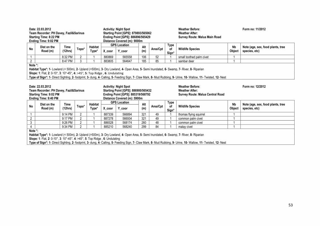
53
Date: 22.03.2012 Activitiy: Night Spot Weather Before: Form no: 11/2012 Team Recorder: PH Davey, Fazil&Sarinus Starting Point [GPS]: 879893/565062 Weather After: Starting Time: 8:22 PM Ending Point [GPS]: 886896/565429 Survey Route: Malua Main Road Ending Time: 9:02 PM Distance Covered (m): 9000m
No Dist on the Road (m)
Time (12hrs)
Topo* Habitat Type*
GPS Location Alt (m)
Area/Cpt Type
of Sign*
Wildlife Species Nb
Object Note (age, sex, food plants, tree species, etc) X_coor Y_coor
1 8:32 PM 2 1 880869 565558 106 52 1 small toothed palm civet 1
2 8:47 PM 3 1 883805 564647 185 85 1 sambar deer 1
Note *: Habitat Type*: 1- Lowland (< 500m), 2- Upland (>500m), 3- Dry Lowland, 4- Open Area, 5- Semi Inundated, 6- Swamp, 7- River, 8- Riparian Slope: 1: Flat, 2: 0-10°, 3: 10°-45°, 4: >45°, 5: Top Ridge , 6: Undulating
Type of Sign*: 1- Direct Sighting, 2- footprint, 3- dung, 4- Calling, 5- Feeding Sign, 7- Claw Mark, 8- Mud Rubbing, 9- Urine, 10- Wallow, 11- Twisted, 12- Nest
Date: 22.03.2012 Activitiy: Night Spot Weather Before: Form no: 12/2012 Team Recorder: PH Davey, Fazil&Sarinus Starting Point [GPS]: 886900/565432 Weather After: Starting Time: 9:02 PM Ending Point [GPS]: 885319/568792 Survey Route: Malua Central Road Ending Time: 9:40 PM Distance Covered (m): 5900m
No Dist on the Road (m)
Time (12hrs)
Topo* Habitat Type*
GPS Location Alt (m)
Area/Cpt Type
of Sign*
Wildlife Species Nb
Object Note (age, sex, food plants, tree species, etc) X_coor Y_coor
1 9:14 PM 2 1 887339 566894 321 49 1 thomas flying squirrel 1
2 9:17 PM 2 1 887278 566934 321 49 1 common palm civet 1
3 9:26 PM 2 1 886528 568174 260 48 1 common palm civet 1
4 9:34 PM 2 1 885210 568240 299 84 1 malay civet 1
Note *: Habitat Type*: 1- Lowland (< 500m), 2- Upland (>500m), 3- Dry Lowland, 4- Open Area, 5- Semi Inundated, 6- Swamp, 7- River, 8- Riparian Slope: 1: Flat, 2: 0-10°, 3: 10°-45°, 4: >45°, 5: Top Ridge , 6: Undulating Type of Sign*: 1- Direct Sighting, 2- footprint, 3- dung, 4- Calling, 5- Feeding Sign, 7- Claw Mark, 8- Mud Rubbing, 9- Urine, 10- Wallow, 11- Twisted, 12- Nest