maldon district council maldon district local …...maldon district council maldon district local...
TRANSCRIPT

Maldon District Council Maldon District Local Development Plan
Rural Employment Evidence
06/02/2017

1. Employment Requirement1.1. Policy E1 is proposing 11.4ha of employment land. Two new sites have been
identified through the preparation of the proposed Site Allocations Development Plan Document as rural employment allocations, The commodity Centre, Great Braxted and Great Hayes Farm , Stow Maries. Combined the allocations equate to 3ha of the total need.
1.2. Both of these sites were considered as existing sites through The Employment Land Review EB102b 2015 and for their potential as new sites. It was then through the proposed Rural Allocations Development Plan Document that the sites were considered for their employment growth potential.
2. Employment Land Review2.1. EB102b The Employment Land Review 2015 identifies both existing and potential
employment sites across the District.
2.2. The criteria used for assessing the market appeal of existing sites can be found in Appendix 1. A summary of the assessment outcomes shown in Table 1. The individual assessment for each site can be found in Appendix 2.
Table 1: Summary of Market Appeal Sites – Existing Sites
1

2.2.1. The majority of the sites that scored highest in Table 2 are located in the Urban Areas. Of those in the Rural Areas both The Commodity Centre and Great Hayes Farm score towards the top of the table in terms of Market Value.
3. Summary of Maldon District Council Assessment
3.1. Using the Employment Land Review as supporting Evidence the Council carried out
an assessment of sites taken from the Employment land review and other sources outlined below in order to find suitable land to accommodate the requirement for B1, B2 and B8 uses in the rural areas.
3.2. The process that was undertaken is outlined below and Appendix 3 shows in greater detail at which stage a site was discounted and the reasons why.
3.2.1. Stage 1: Settlement Sustainability and Site Threshold.
All Settlements within the District outside of the urban areas (Maldon, Heybridge and Burnham-on-Crouch) were considered for their employment growth potential. There was also no size limitation set for the employment sites in the rural areas at this stage. Therefore, this enabled small and larger sites to be considered which could be across the B1, B2 and B8 use classes.
3.2.2. Stage 2: The Long List of Sites
To ensure that all reasonable alternatives have been considered in developing the Plan a long list of potential sites was compiled from the following sources:
• Sites in or around settlements identified in the SHLAA 2014
(Excluding Burnham on Crouch, Heybridge Town and Maldon); • Sites with planning permission for B Class employment as at 31st
March 2014 (excluding Burnham on Crouch, Heybridge Town or Maldon);
• Sites received via a ‘call for sites’ held from September 14th – 31st October 2015;
• Sites received during Duty to Cooperate referrals from neighbouring authorities as part of the call for sites consultation;
• Sites identified in Neighbourhood Plans; • Sites in and around settlements identified by Officers; • Sites identified in the Employment Land Study (outside Burnham on
Crouch, Heybridge Town or Maldon);
A first sieve was undertaken to establish whether these sites should be subject to a more detailed consideration. Employment sites were discounted from further assessment if development would not lead to a net gain in Full-Time Equivalent employment and floor space
2

in the settlement, or if the land has not been put forward for employment use in the ‘Call for Sites.’ The results of this stage can be found in Appendix 4.
3.2.3. Stage 3: Potential Sites – The First Short List (Quantitative)
19 sites were on the short list after the stage 1 and 2 sieves. These sites were then assessed for their sustainability against the employment assessment matrix which can be seen in Appendix 5 and the results of the assessment in Appendix 6.
The methodology used broadly follows the selection criteria identified in EB102a and provides consistency with previous assessments. A colour coding system was used to identify the severity of any constraints as shown in figure 1
The criteria all hold the same level of significance and so the assessment should not be used alone to rank the sites into those that are most suitable but does act as a useful guide.
Sites were only taken forward to the next stage of the plan making process as potential allocations if, following the assessments outlined above, they scored well in terms of suitability, availability and achievability. The results of this stage can be found in Appendix 6.
3.2.4. Stage 4: Potential Sites – The Second Short List (Qualitative)
Under this stage each of the 18 sites that progress from stage 3 are assessed for their qualitative impact which covered more subjective issues such as impact on landscape, heritage, capacity in sewerage, GP’s and education, etc. Sites were referred to other departments and statutory bodies (internally and externally) to assess the appropriateness of the proposed allocations.
Under this stage where there was a judgement made by an officer that development should not take place for reasons such as landscape, highways,
Assessment Definition
No constraints identified, development acceptable in principle or development would have a positive impact
- Neutral impact or there may be constraints, but mitigation is possible
Significant constraints, although mitigation should be possible
Severe constraints where mitigation is unlikely to be possible and development is probably unacceptable
Figure 1: Sustainability Appraisal colour coding
3

etc, these sites were discounted from proceeding to Stage 5. The comments made on the sites from this stage are listed in Appendix 7.
3.2.5. Stage 5: Final Short List
Under this stage the final 8 sites for Employment were known
Not every site getting through to Stage 5 was allocated. Some sites will be more sustainable than others and the most sustainable sites (as shown in the Stage 1-4 assessments) will be put forward as an allocation.
For Employment sites, the main focus was on obtaining enough sites to cater for B1, B2 and B8 employment. Some sites will not be suitable for B8 and also vise-versa. As such sites were chosen on their ability to cater for employment need where some sites may be chosen for their suitability for B8 employment however may be lower in the list of stage 5 sites. A summary of the preferred sites for employment allocation can be found in Table 2 and maps of the sites are in Appendix 9.
A total of 8 sites were included after the final appraisal as shown in Appendix 8. The two selected sites met the criteria, were of sufficient size to meet the need for new employment land identified in the 2015 Employment Study (EB102a) and as existing sites already catered for growing business’s needs. The community Centre site at Great Braxted has since received planning approval.
Site Ref Address Potential Uses E1 Allocation Area (ha)
Deliverability
ES1 Commodity Centre, Braxted Road, Great Braxted
B1, B2, B8 1.2 0-5 years
ES2 Great Hayes Business Centre Lower Burnham Road, Stow Maries
B1, B2, B8 1.8 0-5 years
Total 3ha
Table 2: Summary of the preferred sites for employment allocation
4

Appendix 1: Rationale for Existing Sites Appraisal
Assessment/Criteria Scoring Guidelines Rationale
ACCESS Access to Public Transport Network
VERY GOOD(5 PTS) – Station/Bus Stop within/adjacent to site GOOD (4 PTS) – Within 300m of Rail/Bus Stop FAIR (3 PTS) – Within 800m of Rail/Bus Stop POOR (1 PT) – Further than 800 from PTS
Distance from site entrance to nearest railway station (unless provision is within/adjacent to site)
Proximity to the Strategic Road Network (A12, A120)
VERY GOOD(5 PTS) – Immediately adjacent to SRN GOOD (4 PTS) – Within 2.5 km of SRN and/or frontage to main distributor road eg. A414,A132,B1019,B1018 FAIR (3 PTS) – Within 2.5 and 5 km from SRN and main distributor road eg. A414,A132,B1019,B1018 POOR (1 PT) – More than 5km from SRN
Distance from site to strategic road network (unless provision is within/adjacent to site)
ENVIRONMENTAL QUALITY AND SURROUNDINGS
Internal Environmental Condition VERY GOOD(5 PTS) – Site of highest quality with good landscaping, high spec occupiers and good level of site management GOOD (4 PTS) – Site of good quality with adequate landscaping, some evidence of management and range of occupiers FAIR (3 PTS) – Some attempt made at landscaping and site management. Improvements required in places POOR (1 PT) – Little evidence of landscaping or site management. Site untidy with considerable works required to bring up to standard
Quality of site landscaping in relation to other sites in Borough. On site evidence of site management including upkeep of planting, removal of little/vandalism etc, upkeep of signage.
Noise and Other Pollutants VERY GOOD (5PTS) No on site activities or operations that might limit range of potential uses on site GOOD (4PTS) One or more uses having a minor impact on the quality of the internal environment FAIR (3 PTS) Three or more occupiers giving rise to occassional impact by way of HGV traffic generation, potential contamination or manufacturing activities POOR (1PT) Mainly B2 activities generating significant impacts eg 24 hr working, noise, smell or other form of environmental pollution
Parking Internal Circulation and Servicing
VERY GOOD (5PTS) Car parking in accordance with current LA guidance, designated loading and unloading areas and one-way traffic system GOOD (4 PTS) Adequate parking and loading areas for existing staff and occupiers without parking on estate road FAIR (3 PTS) Restricted access to parts of estate, some loading on estate road, inadequate parking overall, some access constraints for articulated lorries POOR (1 PT) Restricted access to all units, limited off street parking and no access for HGV’s
Local Facilities for Workforce VERY GOOD(5 PTS) – Range of on site facilities GOOD (4 PTS) – Café or shops immediately adjacent to site FAIR (3 PTS) – Local amenities located within 10 minute walk of site entrance POOR (1 PT) – No amenities within 10 minute walk of site
Proximity of site to local amenities including catering, childcare, entertainment, etc
5
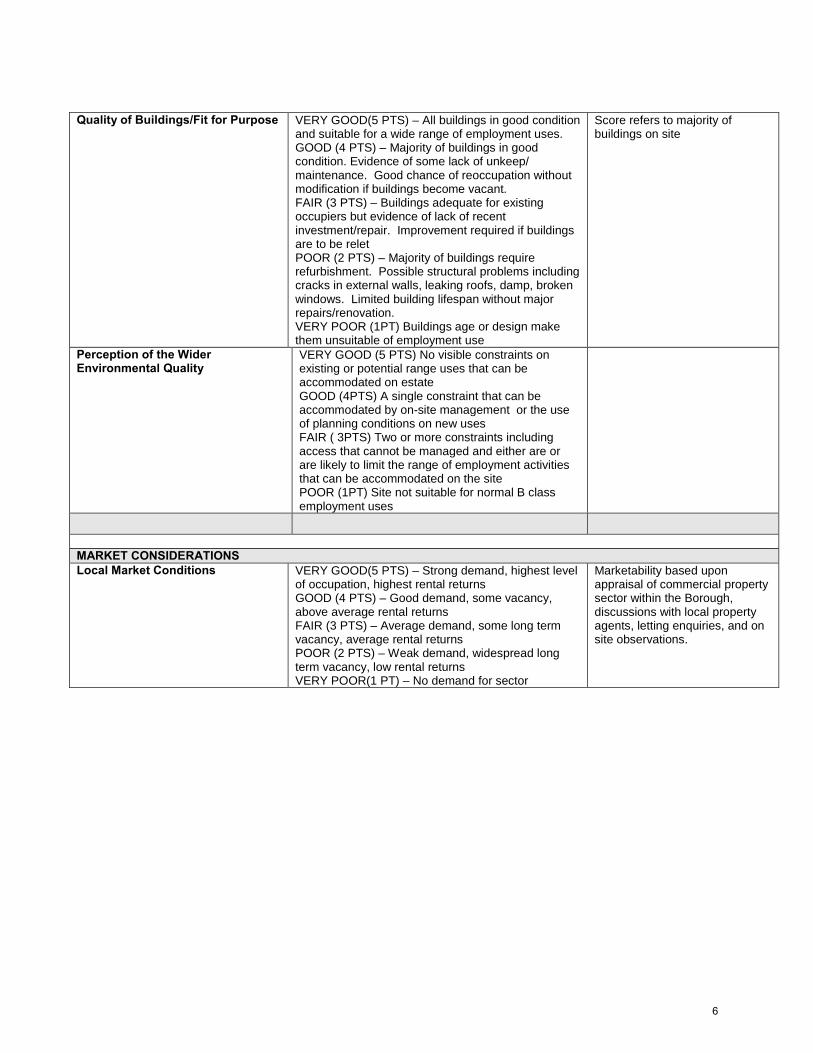
Quality of Buildings/Fit for Purpose VERY GOOD(5 PTS) – All buildings in good condition
and suitable for a wide range of employment uses. GOOD (4 PTS) – Majority of buildings in good condition. Evidence of some lack of unkeep/ maintenance. Good chance of reoccupation without modification if buildings become vacant. FAIR (3 PTS) – Buildings adequate for existing occupiers but evidence of lack of recent investment/repair. Improvement required if buildings are to be relet POOR (2 PTS) – Majority of buildings require refurbishment. Possible structural problems including cracks in external walls, leaking roofs, damp, broken windows. Limited building lifespan without major repairs/renovation. VERY POOR (1PT) Buildings age or design make them unsuitable of employment use
Score refers to majority of buildings on site
Perception of the Wider Environmental Quality
VERY GOOD (5 PTS) No visible constraints on existing or potential range uses that can be accommodated on estate GOOD (4PTS) A single constraint that can be accommodated by on-site management or the use of planning conditions on new uses FAIR ( 3PTS) Two or more constraints including access that cannot be managed and either are or are likely to limit the range of employment activities that can be accommodated on the site POOR (1PT) Site not suitable for normal B class employment uses
MARKET CONSIDERATIONS Local Market Conditions VERY GOOD(5 PTS) – Strong demand, highest level
of occupation, highest rental returns GOOD (4 PTS) – Good demand, some vacancy, above average rental returns FAIR (3 PTS) – Average demand, some long term vacancy, average rental returns POOR (2 PTS) – Weak demand, widespread long term vacancy, low rental returns VERY POOR(1 PT) – No demand for sector
Marketability based upon appraisal of commercial property sector within the Borough, discussions with local property agents, letting enquiries, and on site observations.
6

EXISTING SITES
SITE NAME: The Commodity Centre, Braxted Road, Great Braxted SITE REFERENCE NO: 32
Site Status: Existing employment site Market Sector: B1, B8 Quality of existing portfolio and Internal environment
Internal Environmental Condition: Good condition, a relatively new purpose built development.
Modal age of buildings: 0-25 Quality of buildings/fit for purpose: Very Good
Noise and other pollutants: Good State of the external areas and public realm: Good
Parking internal circulation and servicing: Good
Quality of wider environment Adjacent land uses constraining operations or quality of uses on estate: In a rural location surrounded by agricultural land.
Perception of the wider environmental quality: Very Good
Local facilities for workforce: Poor
Access Access Comments: Accessed via Braxted Road, a very tight lane in places.
Ease of access to main road network: Good
Access by public transport: Poor
Vacant Site Constraints Wider environmental: N/A On-site environmental: N/A
Amenity of adjacent occupiers: N/A Ease of development: N/A
Local Market Conditions Local Market Comments: Let to a single occupier, fully occupied.
Local Market conditions score: Good
Analysis and comments: At the date of inspection a significant extension was under construction.
Appendix 2
7

EXISTING SITES
SITE NAME: Great Hayes Farm, Lower Burnham Road, Stow Maries. SITE REFERENCE NO: 37 Site Status: Developed Market Sector: B1, B2, B8
Quality of existing portfolio and Internal environment Internal Environmental Condition: Generally good, suggestive of recent investment. Modal age of buildings: 15
Quality of buildings/fit for purpose: Good
Noise and other pollutants: Very Good.
State of the external areas and public realm: Good
Parking internal circulation and servicing: Good
Quality of wider environment Adjacent land uses constraining operations or quality of uses on estate: There are some residential property’s to the south west, the remainder agricultural. Perception of the wider environmental quality: Good
Local facilities for workforce: Poor
Access Access Comments: Access is via a dedicated crossover between a pair of sharp bends limiting visibility. Ease of access to main road network: Good
Access by public transport: Poor
Vacant Site Constraints Wider environmental: N/A
On-site environmental: N/A
Amenity of adjacent occupiers: N/A
Ease of development: N/A
Local Market Conditions Local Market Comments: No vacancy noted at inspection
Local Market conditions score: Fair
Analysis and comments: An average sized site demonstrating sign of investment, a reasonably well located site within the context of the Borough.
8

Parish 1st Stage 2nd Stage S3rd Stage S4th Stage SRefGross site (ha) Site Address
Reason for Removal
Althorne Yes Yes Yes Yes E0064 2.29Rear of Black Lion, Althorne
Althorne Yes No 4263c 2.39
Land at Mansion House Farm, Burnham Road, Althorne
Site was not put forward for either B1, B2 or B8 use in the 'Call for Sites'
Cock Clarks Yes Yes Yes No E0029 1.03Birchwood Farm, Cock Clarks.
Landscape - Woodham Wooded Farmland; In open countryside; undulating arable landscape with small woodlands and hedegrows; sense of historic integrity and tranquillity; on edge of village visible on two sides from lanes and potentially from semi-natural greenspace across the road; high sensitivity to change; only suitable for small scale farm-based development
Cold Norton Yes Yes Yes No E0063 14.96St. Stephens Road, Cold Norton
Heritage & Landscape - This land forms an important part of the rural setting of Norton Hall and Norton Hall Barn (both listed grade II) and St Stephen's Church (an undesignated heritage asset). Development of this land, is likely to cause considerable harm to the setting of these heritages assets and be unacceptable. Site is one of undulating wooded farmland, pasture, quiet lanes, dispersed settlement and a sense of tranquility. To the South west there is an aera of semi-natural greenspace. The old railways forms a natural barrier to the village south of Latchingdon Road. The site is highly visible and so the location and scale of development isn't appropriate.
Great Braxted Yes Yes Yes Yes E0032 4.94Commodity Centre, Great Braxted
Great Totham Yes Yes Yes No E0066 1.40
Lofts Farm, B1022, Broad St Green, Great Totham
Landscape - On the western edge of the Tolleshunt Coastal Farmland; gently sloping and open landscape with some intact hedgerows gives long views over site from road and two adjoining PROW; retains strong sense of place and tranquillity; Ancient woodland 180m to the north, PROW 130m to the north and 400m to the east; moderate to high sensitivity; site not suitable for development
Lacthingdon Yes No E0040 15.25
Land at Rectory Lane. Scatterbrook Farm, Latchingdon
Site was not put forward for either B1, B2 or B8 use in the 'Call for Sites'
Appendix 3 Rural Employment Allocations Master Spreadsheet
9

Parish 1st Stage 2nd Stage S3rd Stage S4th Stage SRefGross site (ha) Site Address
Reason for Removal
Latchingdon Yes No E0028 0.84Minervra Centre, Latchingdon
Site will have no positive impact on employment floor space of additional full-time equivalent employment.
Latchingdon Yes No E0033 15.25
Scatterbrook Farm, Rectory Lane, Latchingdon
Site will have no positive impact on employment floor space of additional full-time equivalent employment.
Latchingdon Yes Yes Yes No E0058 2.39Mapledene Chase, Latchingdon
SuDS - The whole of site 9067 is subject to significant surface water flooding and is entirely within floodzone 3. Site 9066 is entirely within flood zone 3 and is at risk of surface water flooding in the eastern corner of the site. Any attenuation storage would need to be proivded as underground sealed storage. It is likely providing treatment on the site would be challanging. All three sites have some existing development on site. Where possible new development should be used to improve suface water flooding issues within the area.
Latchingdon Yes No E0052 3.79Land at Maldon Road, Latchingdon
Site was not put forward for either B1, B2 or B8 use in the 'Call for Sites'
Mayland Yes Yes Yes Yes E0068 7.18Land south of Steeple Road, Mayland
Mayland Yes Yes Yes Yes E0062 5.07Bicknacre Grange, Grange Ave, Mayland
Mayland Yes No E0050 2.20Land North of Steeple Road, Mayland
Site was not put forward for either B1, B2 or B8 use in the 'Call for Sites'
Mayland Yes Yes Yes Yes E0055 1.15Corner of Steeple Road, Maylandsea
Mundon Yes No E0031 0.18Hook farm, Mundon Road, Mundon
Site will have no positive impact on employment floor space of additional full-time equivalent employment.
Mundon Yes Yes Yes No E0051 1.19 Mundon Hall, Mundon
Site will have no positive impact on employment floor space of additional full-time equivalent employment.
10

Parish 1st Stage 2nd Stage S3rd Stage S4th Stage SRefGross site (ha) Site Address
Reason for Removal
Mundon Yes Yes Yes No E0059 2.39Mapledene Poultry Farm, Mundon
The whole of site 9067 is subject to significant surface water flooding and is entirely within floodzone 3. Site 9066 is entirely within flood zone 3 and is at risk of surface water flooding in the eastern corner of the site. Any attenuation storage would need to be proivded as underground sealed storage. It is likely providing treatment on the site would be challanging. All three sites have some existing development on site. Where possible new development should be used to improve suface water flooding issues within the area.
Mundon Yes Yes Yes No E0060 1.01Brookside, Maldon Rd, Mundon
The whole of site 9067 is subject to significant surface water flooding and is entirely within floodzone 3. Site 9066 is entirely within flood zone 3 and is at risk of surface water flooding in the eastern corner of the site. Any attenuation storage would need to be proivded as underground sealed storage. It is likely providing treatment on the site would be challanging. All three sites have some existing development on site. Where possible new development should be used to improve suface water flooding issues within the area.
North Fambridge Yes Yes No E0067 5.03Land at North Fambridge
The site is located within a catchment area where there is no waste water capacity and significant upgrades to waste water capacity are needed, however and this is unlikely to occur within the plan period; or there is no connection to waste water
Purliegh Yes Yes Yes No E0041 3.60Land at Westerings, Purleigh
Landscape & Environmental Health - This site is located adjacent to a large number of residential units to the south east concern about the highlighted area being turned into an industrial area which would change the character of the area and potentially cause loss of amenity through noise, odours and fumes associated with future uses. On the edge of the East Hanningfield Wooded Farmland; gently rolling wooded farmland; quiet lanes, sense of tranquillity; mature field boundaries, some co-axial; relatively high sensitivity to change; large site on rising ground visible from roads and communities to the east; some modest development in the north east of the site may be appropriate if compatible with adjoining education use but otherwise unsuitable for development
11

Parish 1st Stage 2nd Stage S3rd Stage S4th Stage SRefGross site (ha) Site Address
Reason for Removal
Southminster Yes Yes Yes No E0065 6.21Land at Hall Road, Southminster
Archaeology - Site has significant archaeological activity such that it is not considered appropriate for development to take place
Southminster Yes Yes Yes No E0057 5.89Land North of Queen Street, Southminster
Highways & Environmental Health - Road access a concern for HGV's and large scale directly adjacent to residential estate, B2 and B8 a concern. Possible issue with a large B1 due to cumulative effect. No access from Sheepcotes Lane - Queensborough Rd is not suitable for HGV traffic.
Stow Maries Yes Yes Yes Yes E0054 6.02
Great Hayes Business Centre, Lower Burnham Rd, Stow Maries
Tollesbury Yes Yes Yes Yes E0053 1.03
Garlands Farm, North of Tollesbury Road, Tollesbury
Tollesbury Yes Yes Yes Yes E0061 6.21East of Garlands Farm, West St Tollesbury
Tolleshunt D'Arcy Yes No E0038 0.44Station Way, Tolleshunt D'Arcy
Site will have no positive impact on employment floor space of additional full-time equivalent employment.
Tolleshunt D'Arcy Yes No E0049a 4.87Land at Tolleshunt D'Arcy
Site was not put forward for either B1, B2 or B8 use in the 'Call for Sites'
Tolleshunt D'Arcy Yes No E0049b 2.82Land at Tolleshunt D'Arcy
Site was not put forward for either B1, B2 or B8 use in the 'Call for Sites'
Wickham Bishops Yes No E0036 0.31Reigate Farm, Langford Rd, Wickham Bishops
Blackwater Valley; Arable landscape on valley sides; strong sense of place and tranquillity; in open countryside visible from adjoining road and PROW; some long views across and along valley; only suitable for small scale farm-based development
Totals 30 19 18 8
12

Appendix 4: Stage 2: Long List of Sites, Results of the Stage 2 Assessment
RefGross site (ha) Site Address Settlement
Progress to stage 3? Reason for Discounting
E0055 1.15 Corner of Steeple Road, Maylandsea Mayland YesE0050 2.20 Land North of Steeple Road, Mayland Mayland No Site was not put forward for either B1, B2 or B8 use in the 'Call for Sites' 4263c 2.39 Land at Mansion House Farm, Burnham Road, Althorne Althorne No Site was not put forward for either B1, B2 or B8 use in the 'Call for Sites'
E0031 0.18 Hook farm, Mundon Road, Mundon Mundon NoSite will have no positive impact on employment floor space of additional full-time equivalent employment.
E0068 7.18 Land south of Steeple Road, Mayland Mayland YesE0064 2.29 Rear of Black Lion, Althorne Althorne YesE0062 5.07 Bicknacre Grange, Grange Ave, Mayland Mayland YesE0061 6.21 East of Garlands Farm, West St Tollesbury Tollesbury YesE0065 6.21 Land at Hall Road Southminster YesE0054 6.02 Great Hayes Business Centre, Lower Burnham Rd, Stow Maries Stow Maries YesE0060 1.01 Brookside, Maldon Rd, Mundon Latchingdon YesE0032 4.94 Commodity Centre, Great Braxted Great Braxted YesE0066 1.40 Lofts Farm, B1022, Broad St Green, Great Totham Great Totham YesE0057 5.89 Land North of Queen Street, Southminster Southminster YesE0058 2.39 Mapledene Chase, Latchingdon Latchingdon Yes
E0028 0.84 Minervra Centre, Latchingdon Latchingdon NoSite will have no positive impact on employment floor space of additional full-time equivalent employment.
E0033 15.25 Scatterbrook Farm, Rectory Lane, Latchingdon Latchingdon NoSite will have no positive impact on employment floor space of additional full-time equivalent employment.
E0067 5.03 Land at North Fambridge North Fambridge YesE0059 2.39 Mapledene Poultry Farm, Mundon Latchingdon YesE0029 1.03 Birchwood Farm, Cock Clarks. Cock Clarks YesE0052 3.79 Land at Maldon Road, Latchingdon Latchingdon No Site was not put forward for either B1, B2 or B8 use in the 'Call for Sites'
E0036 0.31 Reigate Farm, Langford Rd, Wickham Bishops Wickham Bishops NoSite will have no positive impact on employment floor space of additional full-time equivalent employment.
E0051 1.19 Mundon Hall, Mundon Mundon Yes
E0038 0.44 Station Way, Tolleshunt D'Arcy Tolleshunt D'Arcy NoSite will have no positive impact on employment floor space of additional full-time equivalent employment.
E0041 3.60 Land at Westerings, Purleigh Purleigh YesE0053 1.03 Garlands Farm, North of Tollesbury Road, Tollesbury Tollesbury YesE0040 15.25 Land at Rectory Lane. Scatterbrook Farm, Latchigndon Latchingdon No Site was not put forward for either B1, B2 or B8 use in the 'Call for Sites' E0049a 4.87 Land at Tolleshunt D'Arcy Tolleshunt D'Arcy No Site was not put forward for either B1, B2 or B8 use in the 'Call for Sites' E0063 14.96 St. Stephens Road, Cold Norton Cold Norton YesE0049b 2.82 Land at Tolleshunt D'Arcy Tolleshunt D'Arcy No Site was not put forward for either B1, B2 or B8 use in the 'Call for Sites'
Remaining number of sites: 19Remaining area of land (ha): 78.99
13

Appendix 5: Stage 3: Short list of sites, Appraisal Matrix Employment Sites for the Rural Area
Assessment Definition No constraints identified, development acceptable in principle or
development would have a positive impact - Neutral impact or there may be constraints, but mitigation is
possible Significant constraints, although mitigation should be possible within
the plan period Significant constraints where mitigation is unlikely to be possible
and development is probably unacceptable with the plan period
SA TOPIC SA OBJECTIVE DECISION MAKING CRITERIA SYMBOL SUITABILITY 1. Accessibility To improve accessibility and
transport links from residential areas to key services, facilities and employment areas and enhance access to the natural environment and recreation opportunities
1.1 Access to Strategic Road Network1
1.1.1 Within 2.5kms of the SRN and/or frontage to a main distributer road2
1.1.2 Within 2.5kms and 5kms from a SRN or a main distributor road -
1.1.3 Greater than 5kms from a SRN or main distributor road 1.2 Access to public transport
1.2.1 Within safe walking distance (400m) to public transport to a ‘main settlement3’ with at least a 1 an hour frequency during peak times Monday – Saturday
1 Strategic Road Network is defined as the A12, A130 2 Main distributor Road is defined as A414, B1018, B1019 3 A Main Settlement is defined by Policy S8 of the Emerging Local Plan: Burnham-on-Crouch, Heybridge and Maldon and the following surrounding main settlements in neighbouring areas: South Woodham Ferres, Danbury, Witham, and Hatfield Peverel.
14

SA TOPIC SA OBJECTIVE DECISION MAKING CRITERIA SYMBOL 1.2.2 Within 800m walk to public transport to a ‘main settlement,’ or greater than an hourly frequency during peak times Monday-Saturday
-
1.2.3 None or limited accessibility by public transport Housing Ensure that new housing
provided meets the needs of the area, provide affordable and decent housing for all
All sites are likely to offer similar opportunities to meet this objective; it is not therefore a criterion for choosing between sites.
N/A
2. Health: Improve overall levels of physical, mental and social well-being, and reduce the disparities between different groups and different areas
2.1 Recreational facilities: 2.1.1 Not result in the loss of any indoor or outdoor sporting or recreational facilities
2.1.2 Result in the loss existing indoor or outdoor sporting or recreational facilities, including allotment land.
2.2 Health and Safety: 2.2.1 Not within a specified consultation zone of a notifiable installation (Health and Safety Executive)
2.2.2 The site is partly within a specified consultation zone of a notifiable installation (Health and Safety Executive)
2.2.3 The site is entirely within a specified consultation zone of a notifiable installation (Health and Safety Executive)
Crime To improve community safety, reduce the incidences of crime and the fear of crime - a safe place to live
All sites are likely to offer similar opportunities to meet this objective; it is not therefore a criterion for choosing between sites.
N/A
3. Community: Value and nurture a sense of belonging in a cohesive community whilst respecting diversity and encouraging vibrant communities.
3.1.1 Site will have no specific impact on community facilities other than those specified by Criterion 2.1 (e.g. village halls, community centres, scout huts, church etc.)
3.1.2 Development would result in the loss of a community facility
Skills To improve overall levels of Not relevant to this assessment. It will not assist in choosing between N/A
15

SA TOPIC SA OBJECTIVE DECISION MAKING CRITERIA SYMBOL education and skills sites.
4. Liveability: To create healthy, clean andpleasant environments for people to enjoy living, working and recreating in and to protect and enhance residential amenity.
4.1 Liveability 4.1.1 Local occupiers likely to suffer no or minor disturbance from noise or odour, but generally the impact is low and the proposed employment use will compliment with existing activities and uses
-
4.1.2 Local occupiers exposed to significant noise and odour impacts, but such uses are established and believed to not give rise to nuisance complaints or perceived dangers to health
4.1.3 Significant adverse environmental impact as a result of noise and/or odour which is likely to give rise nuisance complaints
4.2 Residential amenity 4.2.1 Development would be positive to the existing surrounding residential amenity by removing disruptive features associated with the current use(s) of the site. (e.g. noise and or odour; disruptive to the existing residential amenity or surrounding vehicular or pedestrian traffic)
4.2.2 Site has no known effect on the existing surrounding residential amenity
-
4.3 Local Facilities for Workforce4 4.3.1 Range of on-site facilities or café/convenience shop immediately adjacent to the site
4.3.2 Café/convenience store located within 10 minute walk (1000m) of the entrance of the site
-
4.3.3 Café/convenience store greater than 10 minute walk (1000m) of the entrance of the site
5. Biodiversity: To protect, conserve andenhance biodiversity,
5.1.1 Have no effect on any designated site5 or known protected species.
4 Proximity of site to local amenities including catering, childcare, entertainment, etc
16

SA TOPIC SA OBJECTIVE DECISION MAKING CRITERIA SYMBOL geodiversity, wildlife habitats and green infrastructure to achieve a net gain and to avoid habitat fragmentation
5.1.2 Constraints identified although it may be possible for some development with appropriate mitigation.
-
5.1.3 Significant constraints such that it is not considered appropriate for development to take place; or Lead to permanent disturbance of known protected species and extensive land take of their habitat or significant impact on SSSIs, Natura 2000 sites; or Fragment acknowledged areas of habitat
6. Landscapeand Built Form:
To protect and enhance the quality, character and local distinctiveness of the natural and cultural landscape and the built environment
6.1 Existing form of the settlement:
6.1.1 The site is within the existing built up area of the settlement as defined by the development boundary
6.1.2 The site is outside the development boundary and is bordered on 2 or three sides by the built up area6 of the settlement
-
6.1.3 The site is outside the development boundary and is bordered on one side by built up area of the settlement; or The site is outside the development boundary and is detached from the existing built up area of the settlement
6.2 Landscape Sensitivity7
6.2.1 The site is within an area identified as having ‘low’ sensitivity for landscape change
6.2.2 The site is within an area identified as having ‘medium’ sensitivity for landscape change
-
6.2.3 The site is within an area identified as having ‘high’sensitivity for landscape change
7. Cultural Protect and enhance sites, 7.1 Cultural Heritage
5 A designated site includes all international, national and local sites such as RAMSAR, Natura 2000 sites, SAC, SPA, SINC, LWS etc 6 The ‘built up area’ of the settlement is the nucleus or core of the settlement and does not include isolated or sporadic development on the outskirts of the settlement. 7 Landscape sensitivity to change is derived from Braintree, Brentwood, Chelmsford, Maldon and Uttlesford Landscape Character Assessment, Chris Blanford Associates 2006.
17

SA TOPIC SA OBJECTIVE DECISION MAKING CRITERIA SYMBOL Heritage: features and areas of
historical, archaeological, architectural and artistic interest and their settings
7.1.1 Development would be positive by enhancing a designated site or heritage asset (e.g. removing unattractive features or ensuring the survival of a designated site)
7.1.2 Have no effect on a designated site or heritage asset - 7.1.3 No effects or constraints identified although it may be possible for some development with appropriate mitigation (e.g. close to a listed building or other designated site)
7.1.4 Significant constraints such that it is not considered appropriate for development to take place (e.g. development on a SAM, demolition of a listed building)
7.2 Archaeology 7.2.1 Site has no archaeology or archaeological activity or the site has had archaeology excavated in advance of current buildings or previous quarrying practices.
7.2.2 No known archaeology or archaeological activity. Site may have some potential for activity but the area has never been archaeologically investigated.
-
7.2.3 Site has real potential for archaeological activity due to any visual features found on the land (e.g. cropmarks, significant artefact finds, etc.)
7.2.4 Site has significant archaeological activity such that it is not considered appropriate for development to take place
Climate Change
Reduce the emissions of greenhouse gases and the impact of climate change (adaptation)
All sites are likely to offer similar opportunities to meet this objective; it is not therefore a criterion for choosing between sites.
N/A
8. Air To maintain or improve local 8.1.1 Have no ‘detrimental effect8’ on air quality
8 In order to be classified as ‘detrimental’ the development of the site would be very likely to lead to the further exacerbation of an existing Air Quality Management Area, or lead to the designation of a new Air Quality Management Area
18

SA TOPIC SA OBJECTIVE DECISION MAKING CRITERIA SYMBOL air quality 8.1.2 Have some detrimental effects on air quality, but mitigation
would be possible;
8.1.3 Have significant detrimental effects on air quality, with mitigation not being possible.
9. Water: Maintain or improve the quality of ground and surface water resources and minimise the demand for water
9.1.1 Be located predominantly on a sand and gravel strata 9.1.2 Be located on an alluvial or London Clay strata -
10.Natural Hazard:
Reduce the impact of flooding and avoid additional risk
10.1.1 The site is outside a designated flood zone 2 or 3 with minimal impact upon areas which are subject to surface water flooding
10.1.2 The site is outside a designated flood zone 2 or 3, within a known area of surface water flooding
-
10.1.3The site is entirely located in a known area of surface water flooding; and/or The site is partly or entirely located within a Zone 2 flood risk area; and/ or The site is partly affected by a Zone 3 flood risk area.
10.1.4 The site is entirely located within a Zone 3 flood risk area
11. Soil and Land:
Encourage the use of brownfield land and ensure the efficient use of land and maintain the resource of productive soil
11.1 Agricultural land: 11.1.1 The site does not contain any high quality9 agricultural land 11.1.2 Part of the site contains high quality agricultural land - 11.1.3 The site is entirely high quality agricultural land 11.2 Land Stability: 11.2.1 There are no known land stability issues in the area 11.2.2 There are known land stability issues in the area
9 High Quality agricultural land is defined as grades 1 (excellent), 2 (Very Good), and 3a (Good) of the Agricultural Land Classification
19

SA TOPIC SA OBJECTIVE DECISION MAKING CRITERIA SYMBOL 12. Minerals Ensure the efficient use of
minerals and primary resources
12.1.1 The site is located outside of the 250m consultation buffer for minerals safeguarding areas or allocated sites as stated in the Essex Minerals Local Development Plan or is less in area than:
• 5ha of more for sand and gravel • 3ha or more for chalk • Greater than 1 dwelling for brickearth or clay
12.1.2 The site is partially located on a land within the 250m buffer for land allocated/ safeguarded for mineral extraction as stated in the Essex Minerals Local Development Plan where mitigation may be possible and that the site is greater in area than:
• 5ha of more for sand and gravel • 3ha or more for chalk and gravel • Greater than 1 dwelling for brickearth or clay
12.1.3 The site is entirely located on land allocated/ safeguarded for mineral extraction in the Essex Minerals Local Development Plan and would cause detrimental effects by sterilising land for mineral extraction during the plan period
Energy Use To mitigate climate change by minimising carbon based energy usage by increasing energy efficiency and to develop Maldon’s renewable energy resource, reducing dependency on non-renewable resources.
All sites are likely to offer similar opportunities to meet this objective; it is therefore not a criterion for choosing between sites
N/A
13. Waste To reduce waste arising and increase reuse, recycling and composting
13.1.1 The site is located outside of land allocated/ safeguarded for waste infrastructure as stated in the Essex Waste Local Development Plan
13.1.2 The site is partially located on a land allocated/ safeguarded for waste as in the Essex Waste Local Development Plan.
20

SA TOPIC SA OBJECTIVE DECISION MAKING CRITERIA SYMBOL 13.1.3 The site is entirely located on land allocated/ safeguarded for waste extraction in the Essex Waste Local Development Plan and would cause detrimental effects by sterilising land for waste infrastructure during the plan period
14. Waste Water capacity
14.1.1 Site is located in a catchment area which has waste water capacity and no need for upgrade
14.1.2 Site is located in a catchment area which has limited waste water capacity, or no capacity but an upgrade to the existing capacity is highly likely within the plan period
14.1.3 The site is located within a catchment area where there is no waste water capacity and significant upgrades to waste water capacity are needed, however and this is unlikely to occur within the plan period; or there is no connection to waste water
16. Wealth Creation
Retain and enhance the factors which are conducive to wealth creation, including personal creativity, infrastructure and the local strengths and qualities that are attractive to visitors and investors
15.1 Wealth Creation
15.1.1 Site allows for the future creation of further units and employment opportunities and investment
15.1.2 Site has a neutral impact on the provision of employment growth/opportunities and investment
-
15.1.3 Site results in the loss of opportunities for employment growth
Town Centres Protect and enhance the vitality and viability of town centres and market towns
Not relevant to this assessment. It will not assist in choosing between sites.
N/A
PHYSICAL LIMITATIONS
21

SA TOPIC SA OBJECTIVE DECISION MAKING CRITERIA SYMBOL 16.1 Ease of development10:
16.1.1 The site has no obvious physical constraints
16.1.2 Some minor constraints which are able to be overcome within the short term (5 years)
-
16.1.3 One or more constraints which are able to be overcome within the plan period
16.1.4 Constraint/s likely to require significant capital investment in order to be overcome in the longer term (greater than plan period);
16.2 Wider environmental11
16.2.1The site has no obvious visible constraints on uses that can be accommodated on site
16.2.2 The site has a single constraint which may affect the site’s developability, but could be resolved by site/layout design or the use of planning conditions
-
16.2.3 Two or more constraints including access that will limit the range of employment activities than can be accommodated on the site
16.2.4 Site not suitable for normal B2/8 class employment uses 16.3 Ease of utility provision: 16.3.1 Very easy to service 16.3.2 Easy, average or moderately easy -16.3.3 Least easy to service 16.4 Existing Use:
10 Development constraints as follows: Need for reclamation, need for remediation of contamination, need for access improvements onto highway system topological constraints, need for drainage/ services infrastructure; C1/C2 flood risk. 11 Constraints defined as proximity to incompatible uses including housing, access, schools or sewerage works, or potential impact of traffic generation on such uses
22

SA TOPIC SA OBJECTIVE DECISION MAKING CRITERIA SYMBOL 16.4.1 Site is vacant with no current active use 16.4.2 Site is in current active use - 16.4.3 Site is in current active use which may need to be relocated. 16.5 Vehicular access: 16.5.1 Site would contain vehicular access which would have considerable benefits to existing road conditions/ constraints
16.5.2 Vehicular access would be suitable with no known constraints - 16.5.3 Vehicular access unsuitable and/ or restrictive but possible though effective mitigation
18. AVAILABILITY N/A N/A 17.1.1 The site is held by a developer or landowner willing to develop
or the site already has planning permission
17.1.2 Ownership is unknown -
17.1.3 Site is known to be in complex or multiple ownership 17.1.4 Site is owned by a landowner who is known to be unwilling to develop their land.
19. MARKETABILITY 18.1.1 Likely strong demand, some vacancy, above average rental
returns
18.1.2 Likely average demand, some long term vacancy, average rental returns
-
18.1.3 Likely weak demand, widespread long term vacancy, low rental returns
23

1.1.1
1.1.2
1.1.3
1.2.1
1.2.2
1.2.3
2.1.1
2.1.2
2.2.1
2.2.2
2.2.3
3.1.1
3.1.2
4.1.1
4.1.2
4.1.3
4.2.1
4.2.2
4.3.1
4.3.2
4.3.3
5.1.1
5.1.2
6.1.1
6.1.2
6.1.3
6.2.1
6.2.2
6.2.3
7.1.1
7.1.2
7.1.3
7.1.4
7.2.1
7.2.2
7.2.3
7.2.4
8.1.1
8.1.2
8.1.3
9.1.1
9.1.2
10.1.1
10.1.2
10.1.3
10.1.4
11.1.1
11.1.2
11.1.3
11.2.1
11.2.2
12.1.1
12.1.2
12.1.3
13.1.1
13.1.2
13.1.3
14.1.1
14.1.2
14.1.3
15.1.1
15.1.2
15.1.3
16.1.1
16.1 16.1.3
16.1.4
16.2.1
16.2.2
16.2.3
16.2.4
16.3.1
16.3.2
16.3.3
16.4.1
16.4.2
16.4.3
16.5.1
16.5.2
16.5.3
17.1.1
17.1.2
17.1.3
17.1.4
18.1.1
18.1.2
18.1.3
Area (ha) Matrix Id
Site Address - - - - - - - - - - - - - - - - - - - - - - Sum
1.19 E0051 Mundon Hall, Mundon - - - - - - - - - E0051 11 9 9 0 29
1.03 E0053Garlands Farm, North of Tollesbury Road, Tollesbury - - - - - - - - - - - E0053 9 11 9 0 29
7.18 E0068 Land south of Steeple Road, Mayland - - - - - - - - - - - E0068 12 11 6 0 295.03 E0067 Land at North Fambridge - - - - - - - - - - E0067 11 10 7 1 29
6.02 E0054Great Hayes Business Centre, Lower Burnham Rd, Stow Maries - - - - - - - - - E0054 12 9 8 0 29
1.40 E0066Lofts Farm, B1022, Broad St Green, Great Totham - - - - - - - - - - - E0066 11 11 7 0 29
2.39 E0059 Mapledene Poultry Farm, Mundon - - - - - - - - E0059 12 8 9 0 291.01 E0060 Brookside, Maldon Rd, Mundon - - - - - - - - - - - E0060 11 11 7 0 29
6.21 E0061East of Garlands Farm, West St Tollesbury - - - - - - - - - - - E0061 10 11 8 0 29
14.96 E0063 St. Stephens Road, Cold Norton - - - - - - - - - - - - - E0063 7 13 9 0 29
5.07 E0062 Bicknacre Grange, Grange Ave, Mayland - - - - - - - - - - E0062 12 10 7 0 292.29 E0064 Rear of Black Lion, Althorne - - - - - - - - E0064 13 8 8 0 292.39 E0058 Mapledene Chase, Latchingdon - - - - - - - - - - - E0058 11 11 7 0 296.21 E0065 Land at Hall Road, Southminster - - - - - - - - - - - E0065 11 11 7 0 291.03 E0029 Birchwood Farm, Cock Clarks. - - - - - - - - - E0029 11 9 9 0 293.60 E0041 Land at Westerings, Purleigh - - - - - - - - - - E0041 10 10 9 0 291.15 E0055 Corner of Steeple Road, Maylandsea - - - - - - - - - - - E0055 13 11 5 0 29
5.89 E0057Land North of Queen Street, Southminster - - - - - - - - - - - E0057 11 11 7 0 29
4.94 E0032 Commodity Centre, Great Braxted - - - - - - - - - - E0032 12 10 7 0 29
Key: -
Site Totals
10.Natural Hazard9. Water Quality 12. Minerals 16. Physical Limitations - Ease of development, wider environmental, Ease of
utility provision, existing use, vehicular access18.
Marketability17. Availability7.Cultural Heritage Cultural heritage & archaeology
8. Air Quality 13. Waste14. Waste
Water Capacity
15. Wealth Creation
11. Soil and Land Agricultural land,
Brownfield land, Land stability and Land
Contamination
6. Built Form and Landscape
Visual landscape, Existing town form, Character and
setting
5.Biodiversity
Sensitivity and site
type Appendix 6: Stage 3: Employment
Site Assessment Matrix
2. HealthRecreation, Health &
Safety
3. Commu
nity1. Accessibility 4.Liveability
Noise and amenity
24

Matrix Id Site Address Archaeology Comments
E0055 Corner of Steeple Road, Maylandsea
Adjacent to Roman road route, and at head of former Mayland creek, maybe associated archaeological activity.Recommendation: No known archaeology or archaeological activity on the site itself, but there is evidence from the vicinity. Site may have some potential for activity but the area has never been archaeologically investigated. – 7.2.2
E0068 Land south of Steeple Road, Mayland
Adjacent to Roman road route, and at head of former Mayland creek, maybe associated archaeological activity.Recommendation: No known archaeology or archaeological activity on the site itself, but there is evidence from the vicinity. Site may have some potential for activity but the area has never been archaeologically investigated. – 7.2.2
E0064 Rear of Black Lion, Althorne
Site lies adjacent to EHER 38500 – Grade II Listed 18/19th century Public House; EHER 38501 Grade II Listed 18th century row of cottages. To rear of area of possible 16th century purpresture (land enclosure)Recommendation: No known archaeology or archaeological activity on the site itself, but there is evidence from the vicinity. Site may have some potential for activity but the area has never been archaeologically investigated. – 7.2.2
E0062 Bicknacre Grange, Grange Ave, Mayland
Adjacent to Roman road route, and at head of former Mayland creek, maybe associated archaeological activity.Recommendation: No known archaeology or archaeological activity on the site itself, but there is evidence from the vicinity. Site may have some potential for activity but the area has never been archaeologically investigated. – 7.2.2
E0061 East of Garlands Farm, West St Tollesbury
Cropmark complex of probable Roman date (EHER 11533) extends into the proposed area, this is associated with Roman burials and cut features (EHER 47319). Adjacent cropmarks of prehistoric enclosure to south (EHER 11547). Recommendation: Site has real potential for archaeological activity due to any visual features found on the land (e.g. cropmarks, significant artefact finds, etc.) 7.2.3
E0032 Commodity Centre, Great Braxted
E0054Great Hayes Business Centre, Lower Burnham Rd, Stow Maries
E0060 Brookside, Maldon Rd, Mundon
Adjacent to site – EHER10648 – Former WWII road barrier; EHER48459 – Route of Latchingdon rising-main – Archaeological monitoring recovered no archaeological activity in vicinity of site Recommendation: No known archaeology or archaeological activity on the site itself, but there is evidence from the vicinity. Site may have some potential for activity but the area has never been archaeologically investigated. – 7.2.2
E0066 Lofts Farm, B1022, Broad St Green, Great Totham
E0057 Land North of Queen Street, Southminster
Close to the historic hamlet of North End on the outskirts of Southminster (EHER 19416). Moderate potential for Palaeolithic and Pleistocene remains. Extensive cropmark complexes to the north-east, including the Scheduled Oldmoor complex demonstrates widespread prehistoric activity in the vicinity. Recommendation: No known archaeology or archaeological activity on the site itself, but there is evidence from the vicinity. Site may have some potential for activity but the area has never been archaeologically investigated. – 7.2.2
E0058 Mapledene Chase, Latchingdon
Adjacent to site – EHER10648 – Former WWII road barrier; EHER48459 – Route of Latchingdon rising-main – Archaeological monitoring recovered no archaeological activity in vicinity of site Recommendation: No known archaeology or archaeological activity on the site itself, but there is evidence from the vicinity. Site may have some potential for activity but the area has never been archaeologically investigated. – 7.2.2
E0059 Mapledene Poultry Farm, Mundon
Adjacent to site – EHER10648 – Former WWII road barrier; EHER48459 – Route of Latchingdon rising-main – Archaeological monitoring recovered no archaeological activity in vicinity of site Recommendation: No known archaeology or archaeological activity on the site itself, but there is evidence from the vicinity. Site may have some potential for activity but the area has never been archaeologically investigated. – 7.2.2
E0029 Birchwood Farm, Cock Clarks. E0051 Mundon Hall, Mundon
E0053Garlands Farm, North of Tollesbury Road, Tollesbury
E0041 Land at Westerings, PurleighE0063 St. Stephens Road, Cold Norton
E0065 Land at Hall Road
Abutting Scheduled Monument of Pandole Wood SM1002123, EHER 11243-5, 11374. Opposite the medieval manorial complex of Southminster Hall (EHER 11359), which includes the Grade II Listed barn EHER38668. There are extensive cropmark complexes to the immediate north of the site (EHER 45904 and 16027), which includes evidence for prehistoric barrow cemeteries. Moderate potential for Palaeolithic and Pleistocene remains Recommendation: Site has significant archaeological activity such that it is not considered appropriate for development to take place – 7.2.4
Appendix 7: Stage 4: Short List Qualitative Assessment, Archaeology Response
25

Matrix Id Site Address - E0055 Corner of Steeple Road, Maylandsea 13 11 5 0E0068 Land south of Steeple Road, Mayland 12 11 6 0E0064 Rear of Black Lion, Althorne 13 8 8 0E0062 Bicknacre Grange, Grange Ave, Mayland 12 10 7 0E0061 East of Garlands Farm, West St Tollesbury 11 12 6 0E0032 Commodity Centre, Great Braxted 12 10 7 0E0054 Great Hayes Business Centre, Lower Burnham Rd, Stow Maries 12 9 8 0
E0060 Brookside, Maldon Rd, Mundon 11 11 7 0
the whole of site 9067 is subject to significant surface water flooding and is entirely within floodzone 3. Site 9066 is entirely within flood zone 3 and is at risk of surface water flooding in the eastern corner of the site. Any attenuation storage would need to be proivded as underground sealed storage. It is likely providing treatment on the site would be challanging. All three sites have some existing development on site. Where possible new development should be used to improve suface water flooding issues within the area.
E0066 Lofts Farm, B1022, Broad St Green, Great Totham 11 11 7 0
E0057 Land North of Queen Street, Southminster 11 11 7 0
(Site 3903) There is significant surface water flood risk across the south east of the site in both 1 in 30 and 1 in 100 events . However outside of this area there may be some opportunity for infiltration on the site
E0058 Mapledene Chase, Latchingdon 11 11 7 0
the whole of site 9067 is subject to significant surface water flooding and is entirely within floodzone 3. Site 9066 is entirely within flood zone 3 and is at risk of surface water flooding in the eastern corner of the site. Any attenuation storage would need to be proivded as underground sealed storage. It is likely providing treatment on the site would be challanging. All three sites have some existing development on site. Where possible new development should be used to improve suface water flooding issues within the area.
E0059 Mapledene Poultry Farm, Mundon 12 8 9 0
the whole of site 9067 is subject to significant surface water flooding and is entirely within floodzone 3. Site 9066 is entirely within flood zone 3 and is at risk of surface water flooding in the eastern corner of the site. Any attenuation storage would need to be proivded as underground sealed storage. It is likely providing treatment on the site would be challanging. All three sites have some existing development on site. Where possible new development should be used to improve suface water flooding issues within the area.
E0029 Birchwood Farm, Cock Clarks. 11 9 9 0E0051 Mundon Hall, Mundon 11 9 9 0E0053 Garlands Farm, North of Tollesbury Road, Tollesbury 10 11 8 0E0041 Land at Westerings, Purleigh 10 10 9 0E0063 St. Stephens Road, Cold Norton 7 13 9 0
Appendix 7: Stage 4: Short List Qualitative Assessment, SuDS Response
26

Matrix Id Site Address Landscape CommentsE0055 Corner of Steeple Road, MaylandseaE0068 Land south of Steeple Road, MaylandE0064 Rear of Black Lion, Althorne La rgely flat open landscape, moderate to high sensitivity. The linear hedgerows will need to be
retained and a buffer put in place to prevent impact on the open fileds to the North and East. E0062 Bicknacre Grange, Grange Ave, MaylandE0061 East of Garlands Farm, West St Tollesbury Tolleshunt Coastal Farmland; largely flat and open landscape with some intact hedgerows gives long
views over site from road and two adjoining PROW; retains strong sense of place and tranquillity; moderate to high sensitivity; southern half of site only suitable for development
E0032 Commodity Centre, Great BraxtedE0054 Great Hayes Business Centre, Lower Burnham Rd,
Stow Maries This character area has an overall sensitivity to change. There are two footpaths that lead north/north-west from the Lower Burnham Road from where both existing and potentially new buildings might be visible. Great Hayes is also quite visible from the Woodham Road about 500m to the west, especially as the rooves are light in colour.. Any new buildings would not be visible if their height could be kept to the same height or lower. From Little Hayes Chase, about 400m to the south-west, which leads down to the railway and the marsh, the existing buildings are prominent in the view. There is some screening from existing vegetation but visibility of any new buildings is hard to judge and would depend on limiting the height and potentially setting them back. The site is only 600m from
E0060 Brookside, Maldon Rd, MundonE0066 Lofts Farm, B1022, Broad St Green, Great Totham On the western edge of the Tolleshunt Coastal Farmland; gently sloping and open landscape with
some intact hedgerows gives long views over site from road and two adjoining PROW; retains strong sense of place and tranquillity; Ancient woodland 180m to the north, PROW 130m to the north and 400m to the east; moderate to high sensitivity; site not suitable for development.
E0057 Land North of Queen Street, SouthminsterE0058 Mapledene Chase, LatchingdonE0059 Mapledene Poultry Farm, MundonE0029 Birchwood Farm, Cock Clarks. Woodham Wooded Farmland; In open countryside; undulating arable landscape with small
woodlands and hedegrows; sense of historic integrity and tranquillity; on edge of village visible on two sides from lanes and potentially from semi-natural greenspace across the road; high sensitivity to change; only suitable for small scale farm-based development
E0051 Mundon Hall, MundonE0053 Garlands Farm, North of Tollesbury Road,
TollesburyTolleshunt Coastal Farmland; largely flat and open landscape with some intact hedgerows gives long views over farmland ; retains strong sense of place and tranquillity; moderate to high sensitivity; southern half of site only suitable for development
E0041 Land at Westerings, Purleigh On the edge of the East Hanningfield Wooded Farmland; gently rolling wooded farmland; quiet lanes, sense of tranquillity; mature field boundaries, some co-axial; relatively high sensitivity to change; large site on rising ground visible from roads and communities to the east; some modest development in the north east of the site may be appropriate if compatible with adjoining education use but otherwise unsuitable for development
E0063 St. Stephens Road, Cold Norton East Hanningfield Wooded Farmland; undulating wooded farmland, pasture, quiet lanes, dispersed settlement, general sense of tranquillity; Large site to south west of village; crossed and bounded by PROW, lane to St Stephen's Church and area of semi-natural greenspace; old railway forms natural barrier to the village south of Latchingdon Road; highly visible from St Stephen's Road; location and scale of development inappropriate
Appendix 7: Stage 4: Short List Qualitative Assessment, Landscape Response
27

Appendix 7: Stage 4: Short List Qualitative Assessment, Minerals Response Matrix Id Site Address - Total (-
) Minerals Comments
E0055 Corner of Steeple Road, Maylandsea 13 11 5 0 8E0068 Land south of Steeple Road, Mayland 12 11 6 0 6E0064 Rear of Black Lion, Althorne 13 8 8 0 5 The sites considered were either:
E0062 Bicknacre Grange, Grange Ave, Mayland 12 10 7 0 5• Not located within a Minerals Safeguarding Area for either Sand &Gravel/Chalk or BrickEarth/Brick Clay; or
E0061 East of Garlands Farm, West St Tollesbury 11 12 6 0 5
• Those sites within a Sand and Gravel MSA, following applying a 250mbuffer zone from the nearest defined settlement boundary, were no longer greater than 5ha – hence not considered appropriate for mineral extraction
E0032 Commodity Centre, Great Braxted 12 10 7 0 5E0054 Great Hayes Business Centre, Lower Burnham Rd, Stow Maries 12 9 8 0 4E0066 Lofts Farm, B1022, Broad St Green, Great Totham 11 11 7 0 4E0057 Land North of Queen Street, Southminster 11 11 7 0 4E0058 Mapledene Chase, Latchingdon 11 11 7 0 4E0059 Mapledene Poultry Farm, Mundon 12 8 9 0 3E0029 Birchwood Farm, Cock Clarks. 11 9 9 0 2E0051 Mundon Hall, Mundon 11 10 9 0 2E0041 Land at Westerings, Purleigh 10 10 9 0 1E0063 St. Stephens Road, Cold Norton 7 13 9 0 -2
As Mineral Authority we can conclude that the assessment identified no sites that we would be seeking the developer to provide a Minerals
Resource Assessment (MRA).
28

Appendix 7: Stage 4: Short List Qualititative Assessment, Highways ResponseMatrix Id Site Address - Highways CommentsE0055 Corner of Steeple Road, Maylandsea 13 11 5 0 Ok subject to access off of The DriveE0068 Land south of Steeple Road, Mayland 12 11 6 0 Ok subject to safe access being achieved - probable removal of hedge.E0064 Rear of Black Lion, Althorne 13 8 8 0 Ok subject to safe access being achieved - probable removal of hedge.E0062 Bicknacre Grange, Grange Ave, Mayland 12 10 7 0 Ok subject to safe access being achieved - probable removal of hedge.E0061 East of Garlands Farm, West St Tollesbury 11 12 6 0 Ok subject to safe access being achieved - probable removal of hedge.E0032 Commodity Centre, Great Braxted 12 10 7 0 Ok subject to safety and capacity.E0054 Great Hayes Business Centre, Lower Burnham Rd, Stow Maries 12 9 8 0 Ok subject to safe access being achieved.E0060 Brookside, Maldon Rd, Mundon 11 11 7 0
E0066 Lofts Farm, B1022, Broad St Green, Great Totham 11 11 7 0Very likely to be access issues if no improvements can be undertaken to the existing access onto the B1022.
E0057 Land North of Queen Street, Southminster 11 11 7 0No access from Sheepcotes Lane - Queensborough Rd is not suitable for HGV traffic.
E0058 Mapledene Chase, Latchingdon 11 11 7 0E0065 Land at Hall Road 11 11 7 0E0059 Mapledene Poultry Farm, Mundon 12 8 9 0
E0029 Birchwood Farm, Cock Clarks. 11 9 9 0It would have to be demonstrated that the existing access was safe for any intensification above the existing site use.
E0051 Mundon Hall, Mundon 11 9 9 0Well removed from the Strategic Highway Network - unlikely to be supported.
E0053 Garlands Farm, North of Tollesbury Road, Tollesbury 10 11 8 0E0041 Land at Westerings, Purleigh 10 10 9 0E0063 St. Stephens Road, Cold Norton 7 13 9 0
29

Matrix Id Site Address - Heritage commentsE0055 Corner of Steeple Road, Maylandsea 13 11 5 0E0068 Land south of Steeple Road, Mayland 12 11 6 0
E0064 Rear of Black Lion, Althorne 13 8 8 0Erection of buildings on this land could have an impact upon the rural setting of the Black Lion and Black Lion Cottages, which are grade II listed buildings
E0062 Bicknacre Grange, Grange Ave, Mayland 12 10 7 0E0061 East of Garlands Farm, West St Tollesbury 11 12 6 0
E0032 Commodity Centre, Great Braxted 12 10 7 0
New buildings in the south-western corner of the site could have a moderate impact upon the wider rural setting of Appleford Bridge Cottage, which is listed grade II. The impact could be mitigated by a sympathetic design
E0054 Great Hayes Business Centre, Lower Burnham Rd, Stow Maries 12 9 8 0
Development at the southern end of the proposal site could potentially impact upon the setting of the grade II listed farmhouse. But to the north, development would be unlikely to have an unacceptable impact upon setting of the listed building, bearing in mind there are already some modern industrial buildings on this site
E0060 Brookside, Maldon Rd, Mundon 11 11 7 0E0066 Lofts Farm, B1022, Broad St Green, Great Totham 11 11 7 0E0057 Land North of Queen Street, Southminster 11 11 7 0E0058 Mapledene Chase, Latchingdon 11 11 7 0E0065 Land at Hall Road 11 11 7 0E0059 Mapledene Poultry Farm, Mundon 12 8 9 0E0029 Birchwood Farm, Cock Clarks. 11 9 9 0
E0051 Mundon Hall, Mundon 11 9 9 0I would not object in principle to the reuse of the existing farm buildings, although any new structures would need to by sympathetic ot the setting of the grade II listed farmhouse
E0053 Garlands Farm, North of Tollesbury Road, Tollesbury 10 11 8 0
E0041 Land at Westerings, Purleigh 10 10 9 0
The nearest listed buildings are Mill House and Mill Farmhouse, both grade II. The distance between the site and the listed buildings and the level of intervening vegetation is such that development would be unlikely to cause harm to the setting of the listed buidlings. It is not clear from the plan how this site is accessed.
E0063 St. Stephens Road, Cold Norton 7 13 9 0
This land forms an important part of the rural setting of Norton Hall and Norton Hall Barn (both listed grade II) and St Stephen's Church (an undesignated heritage asset). Development of this land, is likely to cause considerable harm to the setting of these heritages assets and be unacceptable.
Appendix 7: Stage 4: Short List Qualitative Assessment, Heritage Response
30

Matrix Id Site Address - Economic Development Comments
E0055 Corner of Steeple Road, Maylandsea 13 11 5 0Good size, location and access, but may be limited with use classes and developer aspirations
E0068 Land south of Steeple Road, Mayland 12 11 6 0Some longer term potential for employment use, but certainly not to the scale of the proposed site.
E0064 Rear of Black Lion, Althorne 13 8 8 0Some potential for employment use, but not to the scale of the proposed site.
E0062 Bicknacre Grange, Grange Ave, Mayland 12 10 7 0Some potential for development of existing site, but not to the proposed scale.
E0061 East of Garlands Farm, West St Tollesbury 11 12 6 0Comparatively large employment site area for a rural location. Likely to be unsustainable.
E0032 Commodity Centre, Great Braxted 12 10 7 0E0054 Great Hayes Business Centre, Lower Burnham Rd, 12 9 8 0 Comparatively large site area for a rural location. Possibly unsustainable.
E0060 Brookside, Maldon Rd, Mundon 11 11 7 0Has potential for further development as an employment site. May have road access issues to address before any further development.
E0066 Lofts Farm, B1022, Broad St Green, Great Totham 11 11 7 0
E0057 Land North of Queen Street, Southminster 11 11 7 0Comparatively large employment site area for a rural location. Possibly unsustainable.
E0058 Mapledene Chase, Latchingdon 11 11 7 0 Has potential for further development as an employment site. May have road access issues to address before any further development.
E0065 Land at Hall Road 11 11 7 0
E0059 Mapledene Poultry Farm, Mundon 12 8 9 0Has potential for further development as an employment site. May have road access issues to address before any further development.
E0029 Birchwood Farm, Cock Clarks. 11 9 9 0E0051 Mundon Hall, Mundon 11 9 9 0E0053 Garlands Farm, North of Tollesbury Road, Tollesbur 10 11 8 0E0041 Land at Westerings, Purleigh 10 10 9 0E0063 St. Stephens Road, Cold Norton 7 13 9 0
Appendix 7: Stage 4: Short List Qualitative Assessment, Econmic Development Response
31

Matrix Id Site Address - E0055 Corner of Steeple Road, Maylandsea 13 11 5 0 B2 or B8 could be an issue due to proximity of housingE0068 Land south of Steeple Road, Mayland 12 11 6 0E0064 Rear of Black Lion, Althorne 13 8 8 0 Quiet rural area, B2 and B8 may be a problem.E0062 Bicknacre Grange, Grange Ave, Mayland 12 10 7 0E0061 East of Garlands Farm, West St Tollesbury 11 12 6 0 Large Site adjacent to residential dwellings, B1 OK, Caution with any B2 and B8E0032 Commodity Centre, Great Braxted 12 10 7 0E0054 Great Hayes Business Centre, Lower Burnham Rd, Stow Maries 12 9 8 0E0060 Brookside, Maldon Rd, Mundon 11 11 7 0E0066 Lofts Farm, B1022, Broad St Green, Great Totham 11 11 7 0E0057 Land North of Queen Street, Southminster 11 11 7 0 Road access a concern for HGV's and large scale directly adjacent to residential
estate, B2 and B8 a concern. Possible issue with a large B1 due to cumulative effect
E0058 Mapledene Chase, Latchingdon 11 11 7 0E0065 Land at Hall Road 11 11 7 0E0059 Mapledene Poultry Farm, Mundon 12 8 9 0E0029 Birchwood Farm, Cock Clarks. 11 9 9 0 This site is in close proximity to residential dwellings west and south. EH would be
concerned about potential noise, fumes, odours associated with a B2 or B8 useE0051 Mundon Hall, Mundon 11 9 9 0E0053 Garlands Farm, North of Tollesbury Road, Tollesbury 10 11 8 0E0041 Land at Westerings, Purleigh 10 10 9 0 This site is located adjacent to a large number of residential units to the south east. We
would be concerned about the highlighted area being turned into an industrial area which would change the character of the area and potentially cause loss of amenity through noise, odours and fumes associated with future uses.
E0063 St. Stephens Road, Cold Norton 7 13 9 0 The scale of this site would change the character of the area, even B1 could affect amenity due to cumulative effects. Large houses to the north and south east could be adversely affected. B2 and B8 likely to be a problem.
Appendix 7: Stage 4: Short List Qualitative Assessment, Environmental Health Response
32

Matrix Id
Site Area (ha)
Settlement Site Address - Total ( difference between & ) Comments
E0055 1.15 Mayland Corner of Steeple Road, Maylandsea 13 11 5 0 8 New Site
E0068 7.18 Mayland Land south of Steeple Road, Mayland 12 11 6 0 6 New SiteE0064 2.29 Althorne Rear of Black Lion, Althorne 13 8 8 0 5 New Site
E0062 5.07 Mayland Bicknacre Grange, Grange Ave, Mayland 12 10 7 0 5 Existing Dwelling
E0061 6.21 TollesburyEast of Garlands Farm, West St Tollesbury 11 12 6 0 5 New Site
E0032 4.94 Great Braxted Commodity Centre, Great Braxted 12 10 7 0 5Expansion of Existing Site (1.2ha available for expansion)
E0054 6.02 Stow Maries Great Hayes Business Centre, Lower Burnham Rd 12 9 8 0 4
Expansion of Existing Site (2.6ha available for expansion, see landscape comments)
E0053 1.03 TollesburyGarlands Farm, North of Tollesbury Road, Tollesbury 10 11 8 0 2 New Site
Remaining number of sites: 8 Proposed Discounted SiteRemaining area of land (ha): 34 Proposed Preferred OptionMinimum Looking to Allocate (ha): 3.8
Appendix 8: Stage 5: Proposed Potential Allocations, Assessment Summary
33

Preferred Site ES1 – Commodity Centre, Braxted Road, Great Braxted
34

Preferred Site ES2 – Great Hayes Business Centre, Lower Burnham Road, Stow Maries
35