malawi arli r mi l ston ag proj t
TRANSCRIPT

MALAWI EARLIER-MIDDLE STONE AGE PROJECT
2013 Project Report
Jessica Thompsona*, Sheila Nightingaleb, Flora Schiltc, David Wrightd, Andrew Zipkine, Alex Mackayf, Christopher Millerc, Menno Wellingg, Victor de Moorg, Jeong-Heon Choih, Susan Mentzerc, and Elizabeth Gomani-Chindebvui
aSchool of Social Science, University of Queensland, Brisbane, QLD, Australia; [email protected]; Tel. +61 7 3365 2765, Fax +61 7 3365 1544* bGraduate Center, City University of New York, New York, NY, United States of America; [email protected] cInstitut für Naturwissenschaftliche Archäologie, AG Geoarchäologie, University of Tübingen, Tübingen, Germany; [email protected]; [email protected]; [email protected] dDepartment of Archaeology and Art History, Seoul National University, Gwanak-gu, Seoul, 151-745, South Korea; [email protected]
eCenter for the Advanced Study of Hominid Paleobiology, George Washington University, Washington D.C., United States of America; [email protected] fCentre for Archaeological Science, University of Wollongong, Wollongong, NSW, Australia; [email protected]
gAfrican Heritage - Research and Consultancy, Zomba, Malawi; [email protected]; [email protected] hDivision of Earth and Environmental Sciences, Korea Basic Science Institute, Ochang Centre, 804-1, YangCheong, Ochang, Cheongwon, Chungbuk 363-883, South Korea; [email protected] iMalawi Department of Culture, Ministry of Tourism, Wildlife, and Culture, Lilongwe, Malawi; [email protected]
*Corresponding author

MALAWI EARLIER-MIDDLE STONE AGE PROJECT UPDATED 17 April 2014
2013 Project Report to the Malawi Ministry of Tourism, Wildlife and Culture
2
CONTENTS
CONTENTS ........................................................................................................................................................ 2
LIST OF FIGURES ............................................................................................................................................ 5
LIST OF TABLES............................................................................................................................................ 11
I. INTRODUCTION ........................................................................................................................................ 12
The Malawi Earlier-Middle Stone Age Project ............................................................................. 12
Summary of MEMSAP Activities to Date ......................................................................................... 13
Summary of Project Outputs to Date ............................................................................................... 18
Summary of 2013 Activities ................................................................................................................ 24
II. CONTEXT OF RESEARCH ..................................................................................................................... 25
Theoretical Background ........................................................................................................................ 25
Malawi Rift Geologic and Tectonic Context ................................................................................... 26
Depositional and Palaeoenvironmental Context ......................................................................... 27
III. SURVEY ...................................................................................................................................................... 29
Overview ..................................................................................................................................................... 29
Rationale and Hypotheses .................................................................................................................... 30
Survey Methods ........................................................................................................................................ 32
Results .......................................................................................................................................................... 34
Discussion ................................................................................................................................................... 38
Further Research ..................................................................................................................................... 42
IV. EXCAVATION ........................................................................................................................................... 43
Overview ..................................................................................................................................................... 43
Methods and Protocols .......................................................................................................................... 43
Results .......................................................................................................................................................... 45
Chaminade III ........................................................................................................................................ 45

MALAWI EARLIER-MIDDLE STONE AGE PROJECT UPDATED 17 April 2014
2013 Project Report to the Malawi Ministry of Tourism, Wildlife and Culture
3
Chaminade IV ........................................................................................................................................ 48
Bruce ........................................................................................................................................................ 49
V. SITE-SCALE GEOARCHAEOLOGY ...................................................................................................... 56
Introduction ............................................................................................................................................... 56
Methods ....................................................................................................................................................... 58
Field Methods ....................................................................................................................................... 58
Micromorphology ................................................................................................................................ 59
Summary of Site Observations ........................................................................................................... 60
Chaminade III ........................................................................................................................................ 60
Chaminde IV .......................................................................................................................................... 61
Bruce ........................................................................................................................................................ 62
North Rukuru (Terrace 1) ................................................................................................................ 67
Karonga-Chitipa Road (Terrace 2) ............................................................................................... 68
Malema .................................................................................................................................................... 68
Chaminade I ........................................................................................................................................... 68
Preliminary Micromorphology Results ...................................................................................... 69
VI. OCHRE ANALYSIS .................................................................................................................................. 71
Overview ..................................................................................................................................................... 71
Methods ....................................................................................................................................................... 71
Results .......................................................................................................................................................... 73
VII. STONE ARTEFACT ANALYSIS ......................................................................................................... 80
Overview ..................................................................................................................................................... 80
Rationale and Objectives ...................................................................................................................... 81
Methods ....................................................................................................................................................... 81
Results .......................................................................................................................................................... 83
Test Pit 8 ................................................................................................................................................. 83

MALAWI EARLIER-MIDDLE STONE AGE PROJECT UPDATED 17 April 2014
2013 Project Report to the Malawi Ministry of Tourism, Wildlife and Culture
4
Test Pit 9 ................................................................................................................................................. 84
Test Pit 10 .............................................................................................................................................. 84
Test Pit 12 .............................................................................................................................................. 85
Test Pit 13 .............................................................................................................................................. 86
Test Pit 20 .............................................................................................................................................. 87
Test Pit 21 .............................................................................................................................................. 88
Chaminade I (CHA-I) .......................................................................................................................... 89
Bruce Area I (BRU-I) .......................................................................................................................... 90
Bruce varia ............................................................................................................................................. 90
Sadala South .......................................................................................................................................... 92
MGD-I ....................................................................................................................................................... 94
MGD-II ...................................................................................................................................................... 96
MGD-III .................................................................................................................................................... 96
Chaminadae III (CHA-III).................................................................................................................. 97
VIII. SUMMARY .............................................................................................................................................. 98
Summary and Conclusions ................................................................................................................... 99
Acknowledgements .............................................................................................................................. 100
IX. REFERENCES CITED .......................................................................................................................... 101
X. APPENDICES .......................................................................................................................................... 107
Appendix 1: Detailed sediment profile descriptions from sites investigated in 2013
...................................................................................................................................................................... 107

MALAWI EARLIER-MIDDLE STONE AGE PROJECT UPDATED 17 April 2014
2013 Project Report to the Malawi Ministry of Tourism, Wildlife and Culture
5
LIST OF FIGURES
Figure 1 Location of study area showing the distribution of MEMSAP excavations to
date. Lake Malawi lies to the right and the Karonga District border is the white line to
the left. Image from Google Earth. ......................................................................................................... 14
Figure 2 Map of Malawi (left) showing the two lake core drill sites within the modern
lake (light blue) and relative to the lake at is maximum reduction during megadrought
periods (dark blue). A close-up of northern Malawi (right) shows Karonga town (star) in
relation to locations of Chitimwe Beds (red). Topography is based on ASTER data (a
product of METI and NASA), with darker colours being lower and lighter colours being
higher. ............................................................................................................................................................... 28
Figure 3 River catchments in the Karonga District. Note the very long, extensive
catchments of the northern rivers (Songwe, Lufira, and North Rukuru) compared to the
short catchments of the southern rivers. Stream order follows Strahler (1992).
Precipitation data are from Hijmans et al. (2005). ......................................................................... 30
Figure 4 Example of survey tracks (yellow lines with white dots) shown against a
basemap of slope generated from ASTER DEM data, a product of NASA and METI (white
star is Karonga town). Blowouts show close-ups of the survey areas with rivers in white
and geological units designated by different letters. Black outlines show outlines of river
catchments produced using the hydrologic tools in ArcGIS. ....................................................... 33
Figure 5 Extent of surveys to date. Yellow lines are 2012 survey paths and pink lines
are 2013 survey paths. White dotted lines show the boundaries of river catchments. The
green star is Karonga town. ..................................................................................................................... 34
Figure 6 Graph showing the cores made on different raw materials in each of the survey
catchments. ..................................................................................................................................................... 36
Figure 7 Graph showing the cores made on different raw materials in each of the survey
catchments. ..................................................................................................................................................... 36

MALAWI EARLIER-MIDDLE STONE AGE PROJECT UPDATED 17 April 2014
2013 Project Report to the Malawi Ministry of Tourism, Wildlife and Culture
6
Figure 8 Numbers of cores (white numbers) shown along survey tracks (white lines).
Grey patches are Chitimwe Beds. .......................................................................................................... 37
Figure 9 Minimum distance to next core using a radial distance function. The clear
clustering of cores is shown by the large number that occur within 25m of another core.
............................................................................................................................................................................. 38
Figure 10 Locations of the main sites excavated in 2013 by MEMSAP and referred to in
the text. Image from Google Earth. ........................................................................................................ 43
Figure 11 Excavation at CHA-III: View north. .................................................................................. 45
Figure 12 Layout of the CHA-III original excavation, the 2013 CHA-III extension trench,
and the CHA-IV 2013 step trench relative to the location of TP7. ............................................ 46
Figure 13 Artefacts by weight from TP7 (left) and section drawing of the west profile of
the excavation at CHA-III (right). Almost no artefacts were recovered below 2m depth.
............................................................................................................................................................................. 46
Figure 14 East view of the distributions of plotted finds excavated from CHA-III in 2012
and in the extension trench in 2013. .................................................................................................... 47
Figure 15 Position of plotted finds at CHA-III relative to geologic units in Figure 13. .. 48
Figure 16 View east up the step trench at CHA-IV. Scale is 1m across. ................................. 48
Figure 17 Configuration of the north profile of the final exposed section at CHA-IV with
plotted finds mapped against the profile. ........................................................................................... 49
Figure 18 Digitised map of hand-annotated sites from materials held by C.V. Haynes
(green stars) superimposed on digitised geological maps (Plc is the Chitimwe Beds) and
with MEMSAP sites identified with yellow circles (CS stands for “Chaminade Survey”
and refers to Test Pits excavated in 2012). Green stars with blue circles around them
represent Clark’s sites with a 100m buffer around them to compensate for the lack of
precision in older maps. Note the proximity of Clark’s Ch-1a to our Bruce, Ch-3 to our
TP8, and Ch-2 to our TP12. ...................................................................................................................... 50

MALAWI EARLIER-MIDDLE STONE AGE PROJECT UPDATED 17 April 2014
2013 Project Report to the Malawi Ministry of Tourism, Wildlife and Culture
7
Figure 19 Google Earth satellite image (October 2012) showing locations of
excavations, interpolated elevations, excavation Areas (yellow), Test Pits (green),
surface collection area (orange), and latrine pits (purple). The spring is indicated in
blue. ................................................................................................................................................................... 51
Figure 20 Potential location of the original 1965 excavations relative to MEMSAP
excavations. .................................................................................................................................................... 51
Figure 21 85m profile along the white line in Figure 19 showing sample intervals with
surface and subsurface topography. ..................................................................................................... 52
Figure 22 Section drawing of the BRU-II east profile. Artefacts represent all plotted
finds from the m2 immediately to the west of the profile; hence “floating” artefacts were
excavated from deposits that were higher or lower in the western part of the square. .. 53
Figure 23 Section drawing of the BRU-I east profile. Artefacts represent all plotted finds
from the m2 immediately to the west of the profile; hence “floating” artefacts were
excavated from deposits that were higher or lower in the western part of the square. .. 54
Figure 24 Section drawing of the BRU-I south profile. Artefacts represent all plotted
finds from the m2 immediately to the west of the profile; hence “floating” artefacts were
excavated from deposits that were in the northern part of the square. ................................. 55
Figure 25 Micromorphological samples CHA III-13-03 (MEM 7237) and CHA III-13-04
(MEM 7236). The samples run parallel to OSL samples LM13-02, LM13-03 (holes to the
right) and LM13-04 (not on this photo). Geological units included are 3-5 and 5-7. Unit 4
and 6 are the pebble layers. ..................................................................................................................... 58
Figure 26 Chaminade IV a) collection of a sample from dm-scale alternating beds of
burned (grey) sediments and unburned reworked lateritic sediment. b) collection of a
sample with known current ant activity in surficial sediments for reference. c) overview
photo from CHA IV towards the west. d) overview of the hill before excavations at CHA
IV were initiated. View to the north-northeast. ............................................................................... 62

MALAWI EARLIER-MIDDLE STONE AGE PROJECT UPDATED 17 April 2014
2013 Project Report to the Malawi Ministry of Tourism, Wildlife and Culture
8
Figure 27 Test Pit 20; a) Overview to the south-west; b) Profile of TP 20 after OSL
sampling but before collection of micromorphological samples; c) During sample
collection. TP 20-13-13 and TP 20-13-14. ......................................................................................... 63
Figure 28 Bottom part of Test Pit 21 (N-profile), showing the lower part of the profile.
Note gravel layer at ca. 15 cm from the bottom, termite channels, and colour difference
after scraping off the oxidised profile surface. ................................................................................. 63
Figure 29 a) Bruce Area I, showing channel beds exposed from erosion on the left and a
channel bed sequence in the excavated area to the right. b) Lowermost part of E-profile,
showing a clayey intraclast inside cm-scale beds of coarse sand and fine gravel). ........... 64
Figure 30 Bruce Area II, view to the southeast. .............................................................................. 65
Figure 31 a) BRU II, E-profile showing the deeper units with artefacts clearly visible in
the profile. b) Insect (termite) nests in upper units on step (W-profile). c) close up of a
fungus garden. d) micromorphological sample of unit 4, including the upper pebble
stringer and artefacts. ................................................................................................................................ 65
Figure 32 South-west corner of Bruce Area III. Collection of micromorphological
samples and carbonate nodules for U-series dating and stable isotope analysis. .............. 66
Figure 33 Secondary carbonates (brackets) crop out in the area of the Bruce
excavations and near the excavations in Mwanganda’s Village. At Mwanganda’s Village,
carbonate as well as water samples were collected in 2012 for reference when
performing isotopic analysis. Elevations were measured at localities where carbonates
outcropped. .................................................................................................................................................... 67
Figure 34 North Rukuru river (left) and cut bank (right). .......................................................... 67
Figure 35 Profile of the Karonga-Chitipa Road site. ...................................................................... 68
Figure 36 Profile of the CHA-I site with OSL ages indicated ...................................................... 69
Figure 37 Photomicrographs of soil thin sections from Mwanganda’s Village Area I. The
features observed in these thin sections show clear evidence for changing soil processes
which are likely related to changing environmental conditions. A) q—quartz grain, cc—

MALAWI EARLIER-MIDDLE STONE AGE PROJECT UPDATED 17 April 2014
2013 Project Report to the Malawi Ministry of Tourism, Wildlife and Culture
9
secondary carbonate nodule, ss—secondary silicates that overprints the secondary
carbonate. PPL. B) I—iron staining (other abbreviations same as is A). Here, secondary
silica overprints secondary iron staining. PPL. C) c—clay coatings; same abbreviations
as before. The iron staining overprints clay coatings. PPL. ......................................................... 70
Figure 38 Locations of ochre sources used in geochemical analysis. ..................................... 72
Figure 39 Ground ochre plaque from Ch-1a (left) and two ground or incised ochre
fragments from the surface of Bruce (right). .................................................................................... 74
Figure 40 Bruce surface artefacts Fe composition (left) compared to Fe composition in
the Chaminade-1a artefacts (right). Left axis is %Fe (FeO + Fe2O3). ..................................... 76
Figure 41 Upper Crust Normalized plot of element concentrations in the Cha-1a (red)
and Bruce (yellow) artefacts. .................................................................................................................. 77
Figure 42 PCA using 34 elemental variables: Each point represents the mean
composition of an artefact, averaged from 5 analyses and standardised to the Fe content
of each artefact, log10 transformed. Red is Ch-1a artefacts and yellow are from Bruce. .. 78
Figure 43 Canonical Discriminant Analysis: Discriminant function built using 34
elements and mean values for all ochre source samples collected. Artefact means
treated as unknown origin and plotted. Red triangles are Ch-1a artefacts and yellow are
from Bruce. ..................................................................................................................................................... 79
Figure 44 Artefacts from TP8 Context 10. ........................................................................................ 83
Figure 45 Refit group 12 (left) and 5 (right) from CHA-I. ........................................................... 89
Figure 46 Map of refitting pieces showing local clustering within the excavation
squares. Each square = 1m2 and north is oriented up in the image. ........................................ 90
Figure 47 Surface finds from Bruce that suggest an older depositional sequence at the
locality. ............................................................................................................................................................. 91
Figure 48 Potential pieces of flaked bone from BRU-II. .............................................................. 92

MALAWI EARLIER-MIDDLE STONE AGE PROJECT UPDATED 17 April 2014
2013 Project Report to the Malawi Ministry of Tourism, Wildlife and Culture
10
Figure 49 Chert handaxe recovered from the Sadala South trench (at rear, ca. 3m deep).
............................................................................................................................................................................. 92
Figure 50 3D (a, b, c) and 2D plan view maps of the distribution of plotted finds (small
black dots) relative to plotted finds that are part of a conjoining unit (coloured circles).
The 3D view (southeast) allows visualisation of the sedimentary units as volumes. ....... 95
Figure 51 Raw material change in the plotted finds from square C4 of CHA-III by
context. ............................................................................................................................................................. 98

MALAWI EARLIER-MIDDLE STONE AGE PROJECT UPDATED 17 April 2014
2013 Project Report to the Malawi Ministry of Tourism, Wildlife and Culture
11
LIST OF TABLES
Table 1 List of the goals for 2013 and activities described in this report that were
undertaken to meet these goals. ............................................................................................................ 24
Table 2 Summary of artefacts and cobbles recorded in detail along survey tracks in
2013. ................................................................................................................................................................. 35
Table 3 All sites sampled, number of samples collected, number of samples processed,
and years in which samples were collected. ..................................................................................... 57

MALAWI EARLIER-MIDDLE STONE AGE PROJECT UPDATED 17 April 2014
2013 Project Report to the Malawi Ministry of Tourism, Wildlife and Culture
12
I. INTRODUCTION
The Malawi Earlier-Middle Stone Age Project
The Malawi Earlier-Middle Stone Age Project (MEMSAP) is a cross-disciplinary project
aimed at understanding changes in human technology, subsistence, and demography
across the time period known as the Middle Stone Age (MSA – from ~ 280 – 30
thousand years ago [ka]). This is only possible with the establishment of long
archaeological and palaeoclimatic sequences embedded within a well-understood
chronometric framework. Because individual sites do not cover this entire time period,
MEMSAP uses a landscape approach to build a long sequence from different sites
present within the exceptional archaeological record of northern Malawi. Ultimately,
this sequence will be used to achieve four project goals:
Goal 1: Characterise significant attributes of technological behaviour throughout the
entire MSA;
Goal 2: Identify important changes in landscape and resource use (specifically lithic
raw materials and water sources);
Goal 3: Link human demographics to climatic variability by identifying if populations
moved during periods of harsh climate; and
Goal 4: Test the following six hypotheses about the timing and mechanisms of
behavioural/demographic change:
H1: There are detectable differences in stone tool manufacturing techniques
over time in a single locality.
H2: Discernible behavioural change took place across the entire Middle Stone
Age (rather than only at the end).
H3: Technological change occurred in concert with changed conditions for the
availability of lithic raw material resources (owing to tectonic and geomorphic
forcing of landscape change).
H4: Behavioural change was most rapid and punctuated during periods of harsh
climate conditions.

MALAWI EARLIER-MIDDLE STONE AGE PROJECT UPDATED 17 April 2014
2013 Project Report to the Malawi Ministry of Tourism, Wildlife and Culture
13
H5: Northernmost Malawi became depopulated during Late Pleistocene
megadroughts as lake levels shrank.
H6: Permanent lakeshores in Malawi acted as population refugia during these
megadroughts.
Several smaller sub-projects have been identified that will be informative on their own
as well as designed to contribute seamlessly to the larger research agenda.
Summary of MEMSAP Activities to Date
Most project activities have taken place near the town of Karonga (Figure 1). To date
these activities have included the emplacement of 19 archaeological excavations,
ranging in size from 50 x 50cm at the smallest to 32 x 2m at the largest (with an average
size of 9m2). Kaufulu (1983) found that the landscape of Karonga does not erode into
tall exposures suitable for field mapping of buried stratigraphic units. Therefore, the
archaeology cannot be contextualised within the greater landscape without
accompanying geological trenches. To this end, 27 geological trenches have been
emplaced both on- and off-site in order to understand the geological/depositional
context of the archaeological finds. An additional 23 test pits have been excavated
archaeologically and described/sampled geologically to serve both archaeological and
geological purposes. An overview of how these activities have proceeded to date is
provided in this section, with details of the 2013 work comprising the remainder of the
report.
In 2009 a pilot survey in Karonga identified key areas for further research (Thompson
et al. 2009), including the ‘elephant butchery site’ at Mwanganda’s Village reported by
Clark and Haynes (1970) and the Airport Site near Chaminade (Thompson et al. 2012a).
The first full MEMSAP season took place in July/August 2010 (Thompson et al. 2011).
Excavations during this season at the Airport Site recovered over 2500 sharp-edged
artefacts from at least two different depositional contexts: an iron pan stratified
between two sandy units and the top of a buried cobble horizon. The most current
presentation of data from the Airport Site can be found in Thompson et al. (2012a). The
artefacts that could not be studied over the course of the 2010 field season were

MALAWI EARLIER-MIDDLE STONE AGE PROJECT UPDATED 17 April 2014
2013 Project Report to the Malawi Ministry of Tourism, Wildlife and Culture
14
exported temporarily to the University of Cape Town, where they were studied by Dr
Alex Mackay. They were returned to Malawi in 2011.
Figure 1 Location of study area showing the distribution of MEMSAP excavations to date. Lake Malawi lies to the right and the Karonga District border is the white line to the left. Image from Google Earth.
In 2010 test excavations were undertaken at the northern site of Kafula Ridge West (in
the Lufira river catchment) and at Mwanganda’s Village (Thompson et al. 2011). The

MALAWI EARLIER-MIDDLE STONE AGE PROJECT UPDATED 17 April 2014
2013 Project Report to the Malawi Ministry of Tourism, Wildlife and Culture
15
small (1 x 1m) excavation at Kafula Ridge West was also a salvage excavation as several
conjoining artefacts were found eroding from a modern channel cut; these were later
dated to approximately 9 ka, and the surrounding geological context was revealed to be
a saprolite blanketed by colluvial remnants of Dinosaur Beds. Although MSA materials
were abundant in the deposits, none were likely to have been in situ. Later surficial
deposits such as the example at Kafula Ridge West were shown to retain substantial
spatial integrity.
At Mwanganda’s Village the fossil- and artefact-bearing palaeosol unit reported by Clark
and Haynes (1970) and Kaufulu (1990) was not relocated in 2010, but a test pit on a
higher terrace ca. 60m to the southeast revealed a lithic assemblage buried under 1.5m
of overburden (Area I). This discovery stimulated excavations in 2011 that resulted in
the recovery and analysis of a larger sample of artefacts that were found to represent an
in situ accumulation of terminal MSA stone artefacts (Thompson et al. 2012b). Many of
these artefacts were found to conjoin, leading to need for a final expansion of this
excavation in 2012 to understand the spatial distribution of conjoining artefacts at the
site. The artefacts from the Mwanganda Area I assemblage were temporarily exported
to the University of Queensland for refitting analysis, then returned to Malawi in 2013
after this study was completed. Some of these data were published in 2013 (Thompson
et al. 2013b) and more results are currently in preparation.
In 2011 excavations at Mwanganda’s Village identified the palaeosol described by Clark
and Haynes (1970) that contained a partial elephant skeleton in association with MSA
stone artefacts. The 2011 investigations (Area III) also showed that subsequent work by
Kaufulu (1990) had not been conducted directly adjacent to the original Clark and
Haynes elephant excavation. Instead, Kaufulu’s geological work had been set adjacent to
a different excavation by Clark and Haynes and the north arrow had been rotated on the
map. Once this was understood, new geological and archaeological goals for
interpreting the site of Mwanganda’s Village were established. The results of this spatial
analysis were published in 2013 (Thompson et al. 2013b), along with new
geoarchaeological interpretations of the site (Wright et al. 2014).

MALAWI EARLIER-MIDDLE STONE AGE PROJECT UPDATED 17 April 2014
2013 Project Report to the Malawi Ministry of Tourism, Wildlife and Culture
16
In 2011 two sites in the Chaminade area near the Karonga airport were also excavated
(Thompson et al. 2012b). The first, Chaminade I, yielded a small artefact assemblage
upon which analysis was initiated in 2012. A manuscript is currently in preparation that
describes the site, its age, and its geological context (also detailed in this report). The
second site, Chaminade II, was the largest excavation to yet be undertaken by MEMSAP.
It was established as a long trench in order to understand subsurface variability in
artefacts and their depositional contexts in deposits that are analogous to the badly
eroded Chaminade badlands area several metres to the west. Fourteen geological
trenches in the Chaminade area were also emplaced, described, and sampled in 2011. A
concurrent survey was undertaken by Mr Andrew Zipkin for possible ochre sources in
the Karonga area. Results from non-artefactual ochre samples have recently been
published from this study (Zipkin et al. 2014, in press).
The first 50 m2 of Chaminade II was excavated as an “off-season” led by staff from the
Malawi Department of Antiquities and following the main 2011 fieldwork. The long
trench was prepared for hand excavation first by a mechanical excavator in order to
access deeply buried MSA deposits. The result was a 2 x 25m excavation down to a
maximum depth of ca. 4m (2m below the level at which the mechanical excavator
ceased digging). Artefact analysis primarily took place in Karonga in 2012 by Ms Sheila
Nightingale. The remaining un-studied artefacts were temporarily exported to the City
University of New York in 2013 and they will be returned to Malawi in 2014.
2012 was a year of peak field and analytical activity for MEMSAP. The main goals of this
season were to complete excavation at Mwanganda’s Village and at Chaminade II, as
well as to understand the greater distribution of sites around Karonga and their larger
regional context of alluvial fan formation (Thompson et al. 2013a). At Mwanganda’s
Village excavation was expanded at both Area I (to a maximum of 25 m2) and at Area III
(to a maximum of 30 m2). The artefacts recovered from Area I were temporarily
exported to the University of Queensland to join those from 2011 for refitting analysis,
and were returned to Malawi with the rest of the assemblage in 2013, where they are
currently fully labelled and organised by raw material type. Analysis of all artefacts
from Mwanganda’s Village was completed in 2013, as detailed in this report. These

MALAWI EARLIER-MIDDLE STONE AGE PROJECT UPDATED 17 April 2014
2013 Project Report to the Malawi Ministry of Tourism, Wildlife and Culture
17
results are in preparation for publication, following from the recent publication
detailing new interpretations of the geoarchaeology of the site (Wright et al. 2014).
At Chaminade II the trench was extended to 32m long (from 25m at the end of the 2011
off-season). A deep sondage at the southern end of the trench was excavated to nearly
6m and sampled for cosmogenic nuclide dating. Two additional cosmogenic nuclide
burial profiles were sampled from geological trenches in river catchments south of
Karonga (Ruasho and Wovwe). Ten geological trenches were excavated in these and
other southern catchments to obtain data on the timing and processes of alluvial fan
formation in the Chitimwe Beds.
Extensive surface survey was also undertaken in 2012. Five days were devoted to
survey by a five-person team around Karonga to identify the distribution of sites and
different artefact types. This resulted in the emplacement of 21 test pits and the
discovery of a site (CS-70) nicknamed “Bruce” that was subjected to three small (1 x
2m) excavations in 2012. These were excavated more deeply, sampled, and described
more fully in 2013, and those preliminary results are reported here. Also in 2012,
twenty-eight linear km in the North Rukuru, Ruasho, and Remero catchments were
surveyed to ascertain the locations of different types of stone artefacts and their degree
of reduction relative to raw materials (e.g. cobbles). These artefacts were described at
their find spots and not collected, as reported in a manuscript that has recently been
accepted for publication (Thompson et al. 2014, in press). An extension of this survey
work was done in 2013, and is reported here.
A second “off-season” excavation was also conducted in 2012, at the site of Chaminade
West (also called Chaminade III). The location was selected based on a continuous
sequence of MSA and LSA artefacts in sharp condition that had been discovered at the
site of Test Pit 7. The site was excavated down to 4m with a series of safety steps. It was
found that a large LSA assemblage with a subsurface slope to the south overlay a series
of sands with MSA artefacts deposited in a laminar fashion. Below this, the site was
archaeologically sterile and did not immediately match the stratigraphy in Test Pit 7. As
a result, an extension trench was excavated in 2013 and is reported here. All

MALAWI EARLIER-MIDDLE STONE AGE PROJECT UPDATED 17 April 2014
2013 Project Report to the Malawi Ministry of Tourism, Wildlife and Culture
18
excavations were fully backfilled by the end of the 2012 field seasons. Those for which
further study was designated in 2013 (e.g. CHA-III and Bruce) were packed with
sandbags and black plastic, and then backfilled.
Summary of Project Outputs to Date
Publications
1) Thompson JC, Mackay A, de Moor V, and Gomani-Chindebvu E. (2014, in press).
Catchment survey in the Karonga District: A landscape-scale analysis of core
reduction strategies and provisioning during the Middle Stone Age of northern
Malawi. African Archaeological Review.
2) Zipkin, A., Hanchar, J., Brooks, A., Grabowski, M.W., Thompson, J.C., and Gomani-
Chindebvu, E. (2014, in press). “Ochre fingerprints: Distinguishing among
Malawian mineral pigment sources with homogenized ochre chip LA-ICPMS”.
Archaeometry.
3) Wright, D.K., Thompson, J.C., Mackay, A., Welling, M., Forman, S., Price, G., Zhao, J-
x., Cohen, A., Malijani, O., and Gomani-Chindebvu, E. (2014). “Renewed
geoarchaeological investigations of the “Elephant Butchery Site” at Mwanganda’s
Village, Karonga, Malawi”. Geoarchaeology 29(2):98-120.
4) Thompson, J.C., Welling, M., and Gomani-Chindebvu, E. (2013). “Using GIS to
integrate old and new archaeological data from Stone Age deposits in Karonga,
Malawi”. International Journal of Heritage in the Digital Era 2(4):611-630.
5) Thompson, J.C., Mackay, A., Wright, D., Welling, M., Greaves, A., Gomani-
Chindebvu, E., and Simengwa, D. (2012). “Renewed Investigations into the
Middle Stone Age of northern Malawi”. Quaternary International 270:129-139.
Conference Presentations and Posters

MALAWI EARLIER-MIDDLE STONE AGE PROJECT UPDATED 17 April 2014
2013 Project Report to the Malawi Ministry of Tourism, Wildlife and Culture
19
1) Thompson, J.C., Welling, M., de Moor, V., Nightingale, S., Mackay, A., Gomani-
Chindebvu, E. (2013). “GIS in linking site and regional scale interpretations of
Middle Stone Age lithic reduction strategies in Karonga, Malawi”. Paper
presented at the 36th annual Australian Archaeological Association Conference,
Coff’s Harbour, NSW, Australia.
2) Zipkin, A.M., Hanchar, J.M., Thompson, J.C., Brooks, A.S., Toth, N.P., Schick, K.D.,
Gomani-Chindebvu, E. (2013). “The trace element geochemistry of archaeological
ochres from Chaminade Hill, Karonga, Malawi”. Paper presented at the 4th
conference of the East African Association for Paleoanthropology and
Paleontology (EAAPP), Mombasa, Kenya.
3) Bravo Foster, M. H., Robinson, S.M., Thompson, J.C., Heimsath, A.M., Fink, D.,
Arrowsmith, J.R. (2013). “Terrestrial cosmogenic geochronology of stratified
Middle Stone Age artefact assemblages, northern Malawi rift, East Africa”. Paper
to be presented at the 125th annual Geological Society of America meeting,
Denver, Colorado, USA. Abstract: GSA Abstracts with Programs 45(7). (Not
delivered)
4) Choi, J.H., Wright, D.K., Thompson, J.C., Chauhan, N., Yeo, E.Y., and Gomani-
Chindebvu, E.(2013). “Investigations on luminescence dating of fluvial sediments
in Palaeolithic sites from northern Malawi – Preliminary Results”. Paper
presented at the Geological Society of Korea.
5) Wright, D.K., Choi, J-H., Nightingale, S., Thompson, J.C., Mackay, A., Welling, M.,
and Gomani-Chindebvu, E. (2013). “Landscape history and human evolution
south-central Africa: Applying new methods to an old problem”. Paper presented
at the 2nd Korea Basic Science Institute International Conference, Ochang, South
Korea.
6) Schilt, F., Mentzer, S., Wright, D.K., Thompson, J.C., Miller, C.E., Gomani-
Chindebvu, E. (2013). “Micromorphology of the site of Mwanganda’s Village Area

MALAWI EARLIER-MIDDLE STONE AGE PROJECT UPDATED 17 April 2014
2013 Project Report to the Malawi Ministry of Tourism, Wildlife and Culture
20
I, northern Malawi”. Paper presented at the Developing International
Geoarchaeology conference and the International Workshop on Archaeological
Soil Micromorphology (WASM), Basel, Switzerland.
7) Thompson, J.C., Zipkin, A., Nightingale, S., Wright, D.K., Choi, J-h., Mackay, A.,
Welling, M., Schilt, F., and Gomani-Chindebvu (2013). “New Discoveries of Old
Sites: The Legacy of J.D. Clark in Karonga, Malawi”. Poster presented at the
Paleoanthropology Society conference, Honolulu, Hawaii, USA. Abstract:
PaleoAnthropology 2013: A36.
8) Thompson, J.C., Welling, M., Wright, D.K., Schilt, F., Mentzer, S., Bravo Foster, M.,
Robinson, S., Mackay, A., Nightingale, S., Forman, S., and Gomani-Chindebvu, E.
(2013). “The Later Pleistocene Archaeological Landscape of Karonga, Malawi”.
Paper presented at the 78th annual Society for American Archaeology conference,
Honolulu, Hawaii, USA.
9) Nightingale, S., Mackay, A., Thompson, J.C., de Moor, V., and Gomani-Chindebvu, E.
(2013). “Variability in Middle Stone Age Stone artefact reduction strategies, and
raw material use in the Karonga District of northern Malawi”. Paper presented at
the 78th annual Society for American Archaeology conference, Honolulu, Hawaii,
USA.
10) Wright, D.K., Choi, J.-h., Thompson, J.C., and Gomani-Chindebvu, E. (2013). “OSL
dating of landscape change and human evolution in northern Malawi”. Paper
presented at the 78th annual Society for American Archaeology conference,
Honolulu, Hawaii, USA.
11) Thompson, J.C., Simfukwe, H., Malijani, O., Chinula, M., Welling, M., and Gomani-
Chindebvu, E. (2012). “Data collection, information transfer, and digital site
visualisation as tools for remote project supervision: Case study from Middle
Stone Age deposits of northern Malawi”. Paper accepted to the High-Tech
Heritage conference, Amherst, Massachusetts, USA (not delivered).

MALAWI EARLIER-MIDDLE STONE AGE PROJECT UPDATED 17 April 2014
2013 Project Report to the Malawi Ministry of Tourism, Wildlife and Culture
21
12) Zipkin, A., Brooks, A.S., Hanchar, J.M., Thompson, J.C., and Gomani-Chindebvu, E.
(2012). “On the formation and distribution of ochre in northern Malawi”. Poster
presented at the 77th annual Society for American Archaeology conference,
Memphis, Tennessee, USA.
13) Thompson, J.C., Wright, D.K., Mackay, A., Forman, S.L., Welling, M., Price, G., Zhao,
J., Gomani-Chindebvu, E. (2012). “Reassessment of the formation and
significance of the Mwanganda’s Village elephant butchery site”, Karonga
District, northern Malawi”. Paper presented at the Paleoanthropology Society
conference, Memphis, Tennessee, USA. Abstract: PaleoAnthropology 2012: A35.
14) Thompson, J.C., A. Mackay, A., de Moor, V., Zipkin, A. Moroney, A., Welling, M., and
Gomani-Chindebvu, E. (2011). “A landscape approach to understanding human
population movements during the Middle Stone Age of northern Malawi”. Paper
presented at the 34th annual Australian Archaeological Association Conference,
Toowoomba, Australia.
15) Thompson, J.C., Welling, M., and Mackay, A. (2010). “Renewed Investigations into
the Middle Stone Age of northern Malawi”. Paper presented at the 13th Congress
of the Pan African Association for Archaeology and Related Disciplines/Society
for Africanist Archaeologists meeting, Dakar, Senegal.
16) Thompson, J.C., Welling, M., and Mackay, A. (2010).“Archaeological tests of
palaeoecological models of central African demography during the Pleistocene”.
Paper presented at the 33rd annual Australian Archaeological Association
Conference, Bateman’s Bay, Australia.
17) Thompson, J.C., Welling, M., Pargeter, J., and Wright, D.K. (2010). “The Malawi
Earlier-Middle Stone Age Project: Preliminary Results from 2009 Fieldwork”.
Poster presented at the Paleoanthropology Society conference, St. Louis,
Missouri. Abstract: PaleoAnthropology 2010: A34.

MALAWI EARLIER-MIDDLE STONE AGE PROJECT UPDATED 17 April 2014
2013 Project Report to the Malawi Ministry of Tourism, Wildlife and Culture
22
Outreach
1) “MEMSAP: Dispatches from the Field” is a blog maintained at
http://www.memsap.org
2) Thompson, J.C. (July 2012). “Archaeology Day: The Malawi Earlier-Middle Stone
Age Project”. Public lecture given at the Karonga Cultural and Museum Centre,
Karonga, Malawi.
3) Zipkin, A.M. (March 2012). “Material Symbolism and Ochre Exploitation in
Middle Stone Age East-Central Africa”. Public lecture given at Memorial
University of Newfoundland, St. John’s, Newfoundland, Canada.
4) Thompson, J.C. (October 2010). “Exploring the void: Human origins research in
forgotten Africa”. Seminar given in the Working Papers in Archaeology series at
UQ.
5) Thompson, J.C. (August 2010). “The earliest archaeology of Kargona – why the
world cares!”. Public lecture given at the Karonga Cultural and Museum Centre,
Karonga, Malawi.
6) Thompson, J.C. (June 2010). “New investigations into the Middle Stone Age of
Malawi”. Seminar given at the University of the Witwatersrand, Johannesburg,
South Africa.
7) Thompson, J.C. (April 2010). “New investigations into the Middle Stone Age of
Malawi”. Seminar given at the Stone Age Institute, Bloomington, Indiana.
8) Thompson, J.C. (August 2009). “A new multidisciplinary research project on the
early prehistory of Malawi”. Seminar at the Catholic University of Malawi
(CUNIMA).

MALAWI EARLIER-MIDDLE STONE AGE PROJECT UPDATED 17 April 2014
2013 Project Report to the Malawi Ministry of Tourism, Wildlife and Culture
23
Project Reports
1) Thompson, J.C., de Moor, V., Schilt, F., Mentzer, S., Bravo Foster, M., Robinson, S.,
Nightingale, S., Mackay, A., Zipkin, A., Wright, D., Welling, M., Malijani, O., and
Gomani-Chindebvu, E. (2013). “Malawi Earlier-Middle Stone Age Project – 2012
Preliminary Project Report”. Unpublished report submitted to Malawi
Department of Antiquities.
2) Thompson, J.C., Welling, M., and Gomani-Chindebvu (2012). “Malawi Earlier-
Middle Stone Age Project – 2011 Interim Project Report”. Unpublished report
submitted to Malawi Department of Antiquities.
3) Thompson, J.C., Mackay, A., and Welling, M. (2011). “Malawi Earlier-Middle Stone
Age Project – 2010 Project Report”. Unpublished report submitted to Malawi
Department of Antiquities.
4) Thompson, J.C., Welling, M., and Pargeter, J. (2009). “Field Report from August
2009 Feasibility Study on the Middle Stone Age of Northern Malawi”.
Unpublished report submitted to Malawi Department of Antiquities.
Education and Training
MEMSAP has hosted a field school in Karonga for the Catholic University of Malawi since
2010 and The University of Queensland since 2011.
MEMSAP has provided essential training for domestic and foreign students,
professionals, and community members through work experience and education. Dr
Jessica Thompson and Dr David Wright have provided letters of strong support for Mr
Oris Malijani, who has worked with MEMSAP since 2010, and who recently received his
choice of two full foreign scholarships to complete a Master’s degree in either Heritage
Management of Archaeological Science abroad in 2013/2014.

MALAWI EARLIER-MIDDLE STONE AGE PROJECT UPDATED 17 April 2014
2013 Project Report to the Malawi Ministry of Tourism, Wildlife and Culture
24
Attention is also brought to the richness of the archaeological record in northern
Malawi via the project’s Facebook website:
http://www.facebook.com/#!/pages/Malawi-Earlier-Middle-Stone-Age-
Project/257887127623607
An online blog called “Dispatches from the Field” has also been maintained for the last
two years at http://memsap.org/.
Summary of 2013 Activities
This report updates the information provided in previous field reports (Thompson et al.
2009, Thompson et al. 2011, Thompson et al. 2012b, Thompson et al. 2013a). MEMSAP
activities in 2013 fell into seven major categories, each with a specific goal (Table 1).
This report describes each of these activities in turn.
Table 1 List of the goals for 2013 and activities described in this report that were undertaken to meet these goals. Item Goal Activity
1 Obtain greater chronological control and geoarchaeological context for two existing sites (CHA-III and BRU)
Re-open backfilled trenches to study profiles and take OSL and micromorphology samples, and excavate a step-trench on the hill to the east of CHA-III
2 Determine the relationship between the Test Pit 7 from 2012 regular season and the Chaminade III site from the 2012 off-season
Extend a trench from CHA-III toward TP7
3 Finalise sample sizes for artefact assemblages at BRU
Completion of excavation of three existing Areas at BRU
4 Assess how core technology, lithic raw material, and ochre sources are distributed across the greater landscape.
Transect surveys of major river catchments draining across the Chitimwe Beds.
5 Prepare for curation of all assemblages recovered to date.
Laboratory work to label and curate artefacts, sort wet-sieved residue, and process sediment samples.
6 Continue analysis of stone artefacts and samples and move the results towards publication.
Continued analysis of stone artefacts and samples.
7 Prepare results to date for publication Manuscripts prepared and submitted to journals.

MALAWI EARLIER-MIDDLE STONE AGE PROJECT UPDATED 17 April 2014
2013 Project Report to the Malawi Ministry of Tourism, Wildlife and Culture
25
II. CONTEXT OF RESEARCH
Theoretical Background
The theoretical impetus for the development of MEMSAP was drawn from debates
about understanding the origins and dispersal of anatomically and behaviourally
modern humans (d'Errico and Stringer 2011). For archaeologists, it has not been well-
understood when, at what pace, and why key behavioural traits first arose in our
species (Chase and Dibble 1990, McBrearty and Brooks 2000, Mellars 2007,
Henshilwood and Marean 2003, Gamble 1994, Klein 2008). However, recent
improvements to the empirical record in eastern and southern Africa have shown that
many of the important changes leading to the modern behavioural suite occurred in
Africa during the Middle Stone Age (MSA). The MSA was a time period that ranged
between ca. 30 – 280 thousand years ago [ka] in east Africa, but possibly started as
early as ca. 500 ka in southern Africa (Tryon et al. 2005, Tryon and McBrearty 2002,
Tryon and McBrearty 2006, Porat et al. 2010, Wilkins et al. 2012). It was also a time that
witnessed a series of severe climatic fluctuations, which likely demanded behavioural
and/or demographic changes in MSA populations (Basell 2008). In Malawi the climatic
story has recently become much better-understood, and shows that a series of
“megadroughts” swept through central Africa during the Late Pleistocene – undoubtedly
impacting local populations (Cohen et al. 2007, Scholz et al. 2011, Scholz et al. 2007).
This background has been thoroughly described in previous reports, which also detail
how these issues relate to the work reported here (Thompson 2010, Thompson et al.
2011, Thompson et al. 2012b, Thompson et al. 2013a).
Research conducted under MEMSAP makes two major contributions to modern human
origins research. First, it provides a rare opportunity to test two major competing
models of the rate of behavioural change during the MSA that cannot be falsified with
shorter sequences from other investigated parts of Africa. Second, it allows the first
direct tests of the climate-driven model for central African megadroughts and their
impact on MSA populations. These contributions are all the more significant because
they will be derived from the central African record, which can bridge existing – and
more abundant – knowledge from the eastern and southern African records.

MALAWI EARLIER-MIDDLE STONE AGE PROJECT UPDATED 17 April 2014
2013 Project Report to the Malawi Ministry of Tourism, Wildlife and Culture
26
Malawi Rift Geologic and Tectonic Context
The archaeological record of Karonga cannot be understood without placing it within its
greater depositional context. Human behaviour and site distributions are structured by
the landscapes upon which they occur. Archaeologically visible resources such as water
sources and stone to make tools are not evenly distributed across the landscape.
Furthermore, northern Malawi contains formidable geophysical barriers – such as Lake
Malawi to the east and a series of highlands to the west – that present differential
foraging opportunities which must be taken into account by mobile hunter-gatherer
groups. Second, since the time of their initial deposition, MSA sites have likely been
affected by numerous post-depositional processes. An understanding of the geological
and geomorphic processes in the area is essential for understanding not only where
sites were likely to have been first created, but also where and how they may have
subsequently become either altered or preserved.
Located on the border of Malawi and Tanzania and to the south of Lake Tanganyika,
Lake Malawi is segmented into three half-graben segments of alternating polarity
(Ebinger et al. 1987, Rosendahl 1987). Each ~50 km wide half-graben is bounded by a
100 km-scale steeply dipping normal fault (Wheeler and Rosendahl 1994, Ring 1994).
The focus of MEMSAP is on the northernmost basin of Lake Malawi, the NW-SE-trending
Tukuyu-Karonga half-graben, which is separated from the central, west-tilted Nkhata-
Mbamba basin by an accommodation zone to the south and bounded by the 120km long
Livingstone fault to the east. There is a marked east-west asymmetry to the deformation
along the Livingstone fault. Whereas a significant amount of crustal deformation is
present on the west side of the hangingwall in the form of numerous synthetic
intrabasinal normal faults, the footwall to the east remains largely undeformed.
Rifting in this section of the East African Rift System (EARS) is likely to have
commenced at 12-8 Ma with throw primarily accommodated on the border fault.
Synthetic intrabasinal faults developed later in each half-graben, breaking up the
footwall both on and offshore (Mortimer, et al. 2007; Biggs et al., 2010). Extension and
subsidence of this basin create the accommodation space required for sediment
aggradation. Measurable extensional activity today is derived from GPS measurements,

MALAWI EARLIER-MIDDLE STONE AGE PROJECT UPDATED 17 April 2014
2013 Project Report to the Malawi Ministry of Tourism, Wildlife and Culture
27
which range from 3.7 to 3.8 mm/yr (Stamps et al. 2008). Maximum subsidence rates
have been calculated at 0.5-1mm/yr in the western branch of the EARS (Einsele 1996),
and average sedimentation rates in the Lake Malawi basin are estimated at ~1mm/yr
(Johnson et al. 2002). The latter rates are less reliable for the deeper sections of the lake
core and basin, but are likely representative of average rates at least back to the
Pleistocene. Still-active intrabasinal faults on the hangingwall, many of which lie on the
western margin of Lake Malawi, also influence sedimentation patterns within the basin
(Biggs et al. 2010, Fagereng 2013).
Depositional and Palaeoenvironmental Context
On the steep, eastern margin of the basin, high slope and local relief characterise the
bare-bedrock, mountainous landscape. Within the eastern depths of the lake, thick
sedimentary sections indicate a total of ~6 km throw (Ebinger et al. 1999) along the
Livingstone Fault, creating a ~2 km-high escarpment at the front of the Livingstone
Mountains. The western hangingwall landscape is comprised of mostly gently-sloping
and incised alluvial surfaces. These sediments grade down to the half-graben fill
beneath Lake Malawi, creating a 5-10 km wide coastal plain of Quaternary sediments.
These sediments include the Middle-Late Pleistocene Chitimwe Beds, which outcrop
along this stretch in areas of up to 20km2 (Figure 2), unconformably overlying Pliocene
lacustrine/near-shore sediments known as the Chiwondo Beds (Kaufulu et al. 1981).
The Chitimwe Beds are also a rich source of Stone Age artefacts, a preponderance of
which are typologically assigned to the Middle Stone Age (Thompson et al. 2011,
Thompson et al. 2012b, Thompson et al. 2014, in press, Clark 1966).
The abundant MSA record of northern Malawi received its first detailed attention in the
1960s from J. Desmond Clark (Clark 1966, Clark et al. 1966, Clark et al. 1970, Clark and
Haynes 1970). The exposures reported by Clark near the Chaminade Secondary School
in Karonga are representative of a subset of MSA deposits that are rich in both lithic raw
materials in the form of cobbles and artefacts manufactured on those cobbles (Clark
1966, Clark 1968, Clark et al. 1967, Clark et al. 1966, Clark 1972, Clark and Haynes
1970). This phenomenal abundance of artefacts means that large, meaningful samples
can be excavated to compare human adaptations across time and space.

MALAWI EARLIER-MIDDLE STONE AGE PROJECT UPDATED 17 April 2014
2013 Project Report to the Malawi Ministry of Tourism, Wildlife and Culture
28
Figure 2 Map of Malawi (left) showing the two lake core drill sites within the modern lake (light blue) and relative to the lake at is maximum reduction during megadrought periods (dark blue). A close-up of northern Malawi (right) shows Karonga town (star) in relation to locations of Chitimwe Beds (red). Topography is based on ASTER data (a product of METI and NASA), with darker colours being lower and lighter colours being higher.
Accompanying this outstanding MSA record is one of the longest and most detailed
terrestrial palaeoclimate records in Africa, which was derived from cores taken from
sediments in the northern basin of Lake Malawi (Cohen et al. 2007, Scholz et al. 2007,
Scholz et al. 2011). These records show that several periods of ‘megadrought’ occurred
in central Africa between ca. 135 – 75 ka, during which time water volumes in Lake
Malawi were reduced by as much as 95% (Brown et al. 2007, Cohen et al. 2007, Scholz
et al. 2007, Stone et al. 2011) and exposing human populations to significant periods of
resource change (Figure 2). In addition to the impact on humans, major changes in base
level at Lake Malawi would have initiated a landscape response, affecting the deposition
and subsequent alteration of MSA sites entrained within them.

MALAWI EARLIER-MIDDLE STONE AGE PROJECT UPDATED 17 April 2014
2013 Project Report to the Malawi Ministry of Tourism, Wildlife and Culture
29
III. SURVEY
Overview
Mobility is a key adaptive strategy among modern foragers in arid regions, who
cope with the effects of drought through “drought escape” (abandonment of affected
areas) and “drought evasion” (population fragmentation into areas with reliable surface
water) (Gould 1991). The stone artefact record offers durable evidence of such human
mobility strategies that can inform about decision-making, land use, and the presence or
absence of human populations (Dietl et al. 2005, Barut 1994, McCall 2007). This is
especially relevant in areas such as northern Malawi, where “megadrought” periods
imposed significant changes in resource configuration on people living there in the Late
Pleistocene. The abundance of surface artefacts in Karonga, especially within and
around the Chitimwe Beds, offers a unique opportunity to provide the first regional-
scale analysis of MSA land use in central Africa by testing hypotheses about how MSA
populations adjusted foraging patterns in response to periods of resource change such
as drought. In order to achieve these goals, survey was performed in 2013 of a series of
major river catchments in Karonga. This survey built on pilot fieldwork from 2012
(Thompson et al. 2014, in press), where patterning was identified with respect to
different types of stone raw material availability and their use by MSA people.
Specifically, that work found that there are important differences in what types of stone
and other resources are available between the north and south of the Karonga District.
It is this dichotomy that promises to offer significant and novel insights into MSA land
use strategies and response to fluctuating resources over time, and thus the survey was
designed to sample parts of both areas.
Surveys were conducted by Oris Malijani, Victor de Moor, Davie Simengwa, and James
Flittner. The 2013 surveys focussed on two features. Firstly, the analysis focussed on
cores, the single most informative type of artefact for analysing stone tool production
strategies. Secondly, analysis also included unmodified cobbles, the raw stone material
sources mainly in use in the area during the Middle Stone Age. Stone artefacts were not
collected, but were recorded and photographed at their find spots.

MALAWI EARLIER-MIDDLE STONE AGE PROJECT UPDATED 17 April 2014
2013 Project Report to the Malawi Ministry of Tourism, Wildlife and Culture
30
Rationale and Hypotheses
The Chitimwe Beds lie within a series of river catchments bounded to the west by
highlands and the east by Lake Malawi. This “closed” landscape and the uneven
distribution of stone, water, and vegetation resources in Karonga allows for the testing
of novel hypotheses about patterns of MSA land use at scales most relevant to past
mobile foragers. All rivers drain east and are dominated by three large catchments that
define the northern landscape (Figure 3). Their lower reaches contain quartzite cobbles
of high quality for stone tool manufacture(Stephens 1966). Thus, foragers moving east-
west would have crossed diverse environmental zones and resource patches along a
topographic gradient. Although maintaining regular access to fresh water, they would
have needed to visit the lower catchments to obtain the best toolstone.
Figure 3 River catchments in the Karonga District. Note the very long, extensive catchments of the northern rivers (Songwe, Lufira, and North Rukuru) compared to the short catchments of the southern rivers. Stream order follows Strahler (1992). Precipitation data are from Hijmans et al. (2005).
In contrast, the southern landscape comprises many smaller catchments where the
majority of cobbles are small, medium-quality quartz (Thompson et al. 2014, in press).
South of Karonga town rainfall plateaus at ca. 1000 mm and the highly seasonal

MALAWI EARLIER-MIDDLE STONE AGE PROJECT UPDATED 17 April 2014
2013 Project Report to the Malawi Ministry of Tourism, Wildlife and Culture
31
conditions are semi-arid to arid most of the year. In the north, rainfall nearly doubles to
1800 mm and vegetation is lusher year round (Hijmans et al. 2005) (Figure 3, inset).
Foragers moving from north to south would have experienced less topographically-
controlled environmental variability but longer distances between surface water,
increasing distance from the best stone materials, and increasing aridity. These effects
would have been exaggerated during periods of drought.
Blome et al. (Blome et al. 2012) suggest that early human populations in tropical Africa
adapted to major climatic changes by moving and reconfiguring rather than completely
depopulating large areas. Both have been observed to be strategies employed by
modern foragers and recent archaeological populations in arid environments (Gould
1991, Veth 2008). Areas of high topographic variability (northern Karonga) are
impacted more slowly by climate change than low-lying and arid areas (southern
Karonga) because topographically diverse regions have a slow ‘velocity of temperature
change’ along their gradients (Loarie et al. 2009). How humans responded to this
resource differential can be examined for the MSA of Karonga within the theoretical
frameworks of provisioning and risk mitigation, which both draw from optimal foraging
theory (Thompson et al. 2014, in press, Bousman and Cruz-Uribe 1998).
We hypothesise that the orographically-controlled and seasonal aridity of the smaller
southern catchments would have translated to the riskiest (most uncertain) conditions
in Karonga. In contrast, the northern catchments would have had the highest potential
for the persistence of refugia during extreme arid periods (Basell 2008), as the area
they cover receives greater precipitation, contains higher-quality toolstone, has less
ephemeral surface water, and enjoys high topographic (and therefore resource)
variation. Therefore, drought evasion strategies should have dominated the southern
catchments, overprinted by periods of drought escape. In the north, there should be
more continuous records of human occupation and evidence of less long-range mobility.
Test implications for the southern catchments relative to the northern catchments are:
1) there should be more catchment-specific use of lithic resources, expressed through
raw material prevalence relative to local availability; 2) there should be greater
variation in artefact curation and/or cortex ratio values, because frequent long linear
movements – typical of open and unpredictable settings – will create imbalances in

MALAWI EARLIER-MIDDLE STONE AGE PROJECT UPDATED 17 April 2014
2013 Project Report to the Malawi Ministry of Tourism, Wildlife and Culture
32
cortex proportions (Douglass et al. 2008); 3) there should be periods where little
archaeological material is deposited; 4) there should be fewer sites per area of
preserved deposit and fewer artefacts per site; 5) there should be less evidence for
group aggregation in the form of ochre use, diverse stone artefact forms, and diverse
raw materials; and 6) there should be more investment in technological complexity
(Hiscock 1994), increased flaking efficiency (Mackay 2008), and tool curation as buffers
to subsistence and movement uncertainty - especially during periods of drought
(Torrence 1989).
Survey Methods
This aspect of MEMSAP work rejects the notion of “site”-based analysis (Dunnell 1992),
in favour of understanding palimpsests of human behaviour at the landscape scale
(Fanning et al. 2009, Fanning et al. 2008, Holdaway and Fanning 2008). Large-scale
surveys are required since surface cores and cobbles are analysed instead of large
assemblages of in situ artefacts. This approach is applied because abundant sources of
lithic raw materials, such as river or river terrace cobbles, are available on the entire
landscape. In addition, geomorphologic aspects of the survey areas and taphonomic
processes on the artefacts are taken into account. The objectives of the surveys are to
investigate differences in raw material availability between the catchments and in
relation to this, the possible variation in lithic reduction strategies within these
catchments.
From 2011 onwards a system of analysis has been developed for studying and
recording the artefacts on their find spots in the field during the surveys. Details of what
attributes are recorded are provided in Thompson et al. (2014, in press). Hand-held GPS
was used to record survey tracks. With the help of geological maps of the Karonga
District – and geomorphologic research executed by MEMSAP geologists simultaneous
with the surveys – possible Chitimwe exposures on the surface were investigated. To
find the locations where the Chitimwe Beds and MSA artefacts are exposed on the
surface, geological maps of the study area were used, as well as information from recent
geological surveys executed by MEMSAP geologists. Geological maps from the Malawi
Ordnance Survey 1976 have been digitised into ArcGIS and can be displayed relative to
survey tracks, as shown in Figure 4.

MALAWI EARLIER-MIDDLE STONE AGE PROJECT UPDATED 17 April 2014
2013 Project Report to the Malawi Ministry of Tourism, Wildlife and Culture
33
Figure 4 Example of survey tracks (yellow lines with white dots) shown against a basemap of slope generated from ASTER DEM data, a product of NASA and METI (white star is Karonga town). Blowouts show close-ups of the survey areas with rivers in white and geological units designated by different letters. Black outlines show outlines of river catchments produced using the hydrologic tools in ArcGIS.
During the survey, angles of hill slopes were measured and estimated with the help of a
clinometer. The percentage of visibility of the surface of the landform area was
determined, as well as the percentage of exposure of the artefacts, which indicates what
one would expect to see on the surface of the landform if the visibility was perfect. This
system of archaeological surveying is based on the Code of Practice for Archaeological
Investigation of Aboriginal Objects in New South Wales. Care was taken record the
artefact and transect attributes without straying from the transect itself. For example, if
a large concentration of artefacts and cobbles was found, cores and artefacts outside the
survey path were not recorded. In this way, comparisons could be made between
characteristics of stone artefacts across the survey transect without adding undue bias
from areas where artefacts were concentrated (2014, in press).

MALAWI EARLIER-MIDDLE STONE AGE PROJECT UPDATED 17 April 2014
2013 Project Report to the Malawi Ministry of Tourism, Wildlife and Culture
34
Results
In 2013 the emphasis was on extending survey into areas that were not covered in 2012
(Figure 5). These mainly included northern areas within the Songwe and Lufira
catchments and southern areas within the Nyungwe and Wovwe catchments. In order
to promote fuller coverage, the Wayi (in the central part of the Karonga District), and an
area around Kayelekera (in the western part of the District) were also surveyed.
A total of 391 artefacts were recorded, along with a sample of 420 cobbles (Table 2).
This is in addition to the sample of 280 cores and 501 cobbles recorded in 2012. One
thing that is immediately apparent is the scarcity of Levallois flakes, the total lack of
Levallois points, and the near-total lack of blades in the 2013 sample.
Figure 5 Extent of surveys to date. Yellow lines are 2012 survey paths and pink lines are 2013 survey paths. White dotted lines show the boundaries of river catchments. The green star is Karonga town.

MALAWI EARLIER-MIDDLE STONE AGE PROJECT UPDATED 17 April 2014
2013 Project Report to the Malawi Ministry of Tourism, Wildlife and Culture
35
Table 2 Summary of artefacts and cobbles recorded in detail along survey tracks in 2013. Cores Cobbles Levallois flakes Levallois points Blades Songwe (Ighembe Ridge)
34 40 5 0 2
Songwe (Iponga)
93 90 3 0 0
Lufira (Kafula Ridge)
64 60 0 0 0
Wayi (Lupembe)
80 90 4 0 1
Western N. R. (Kayelekera)
10 20 2 0 0
Wovwe 45 50 1 0 0 Wovwe (Uraha)
22 20 0 0 0
Nyungwe 43 50 1 0 0 Total 391 420 16 0 3
Another striking result from the 2013 data is its confirmation of a pattern found in
2012, where there was a shift in raw material use from the north of the District to the
south. Specifically, quartz was rarely used north of the Remero, where normally ~90%
of cores were produced on fine-quality quartzite. This occurred even where quartzite
was uncommon in its abundance in local cobbles; for example in the Sadala region,
where only ~50% of available cobbles are quartzite, ~90% of artefacts were made on
this material. Raw material use did follow local trends in cobble abundances: where
quartzite was more common, it was more commonly used, and where quartz was more
common it was more commonly used. However, within these constraints there was
clear preference for higher-quality stone. In the north this was quartzite, and in the
south that preference became translated to a preference for higher-quality quartz than
was commonly available in the north.
The 2013 surveys confirmed this pattern dramatically. When this dataset is combined
with the 2012 data, a clear pattern of increasing use of quartz begins with the Remero
catchment and gradually declines south into the Wowve (Figure 6). This trend is highly
statistically significant, as shown by the Chi-squared test for trend (X2 = 249.641; df = 1;
p < 0.0001). However, there is also a clear change in raw material use between the
Wayi, where quartzite is clearly still preferred, to the Remero, where approximately half
of all cores were manufactured on quartz.
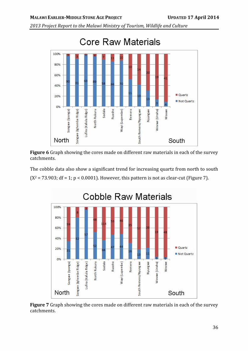
MALAWI EARLIER-MIDDLE STONE AGE PROJECT UPDATED 17 April 2014
2013 Project Report to the Malawi Ministry of Tourism, Wildlife and Culture
36
Figure 6 Graph showing the cores made on different raw materials in each of the survey catchments.
The cobble data also show a significant trend for increasing quartz from north to south
(X2 = 73.903; df = 1; p < 0.0001). However, this pattern is not as clear-cut (Figure 7).
Figure 7 Graph showing the cores made on different raw materials in each of the survey catchments.

MALAWI EARLIER-MIDDLE STONE AGE PROJECT UPDATED 17 April 2014
2013 Project Report to the Malawi Ministry of Tourism, Wildlife and Culture
37
There is a strong correlation between raw material use and raw material abundance (Rs
= 0.8601, p < 0.001). However, there are also clear peaks in the presence of quartzite.
These occur, as would be expected, in areas close to the Sungwa conglomerates that
make up part of the Dinosaur Beds. However, today the Sungwa Beds are restricted to
very small areas within the North Rukuru. The presence of many high-quality quartzites
in the Lufira and southern part of the Songwe catchments suggest that these areas once
contained Sungwa conglomerates that have now been completely reworked into stream
beds and terraces.
Most analyses that have been performed to date have been based on 2012 survey data,
which showed several patterns in terms of core abundances and clustering. Numbers of
cores and where they were found along individual survey tracks are shown in Figure 8.
Figure 8 Numbers of cores (white numbers) shown along survey tracks (white lines). Grey patches are Chitimwe Beds.

MALAWI EARLIER-MIDDLE STONE AGE PROJECT UPDATED 17 April 2014
2013 Project Report to the Malawi Ministry of Tourism, Wildlife and Culture
38
Based on 2012 survey data, it was found that cores are strongly clustered together
(Figure 9), but that there does not appear to be any direct correlation between cores
and cobble abundances. Nor was there any definitive restriction of cores to beds
mapped as Chitimwe Beds – though this may be a consequence of the large scale at
which the maps are available. Analysis of the 2013 survey data is currently underway.
Figure 9 Minimum distance to next core using a radial distance function. The clear clustering of cores is shown by the large number that occur within 25m of another core.
Discussion
Significant progress has been made toward understanding human land-use and
technological organisation in the Karonga district during the MSA. The limitations of our
approach have been a lack of chronological control in an erosional landscape and the
resulting palimpsest problem with its potential to obscure temporally-mediated spatial
patterns. Our results display consistency in spite of this.

MALAWI EARLIER-MIDDLE STONE AGE PROJECT UPDATED 17 April 2014
2013 Project Report to the Malawi Ministry of Tourism, Wildlife and Culture
39
A surprising result of GIS analysis of the 2012 data was that although focus was placed
on surveying exposures with Chitimwe Beds, these mapped deposits actually contained
some of the lowest estimates of cores per m2. In contrast, gneiss bedrock had much
higher than expected estimates of core quantities. This is likely because most of the
cores analysed from bedrock deposits were from the North Rukuru survey, in an area
where mapped bedrock is blanketed with a veneer of cobbles in colluvial and proximal
alluvial fan settings. Cores from this survey show relatively high amounts of weathering
and are on average larger, further supporting the inference that they represent part of a
lag deposit rather than cores manufactured after the fact on top of a lag deposit.
A possible explanation for the apparent paucity of cores in the surveyed Chitimwe Beds
areas comes from geomorphic observations and archaeological excavations near the
town of Karonga (Thompson et al. 2012a, Wright et al. 2014). These studies have
established that although MSA artefacts occur abundantly within the Chitimwe Beds,
they are commonly deeply buried in the upper sands. When they erode, they frequently
do so from the shoulders of local topographic highs and lag onto a cobble/pebble base
or into gullies incised into the softer underlying Pliocene lacustrine sediments of the
Chiwondo Beds. This scenario is consistent with the survey data on exposure, as well as
the artefacts themselves. Cores from the Chitimwe Beds had the smallest average
degree of weathering and large numbers of them were recorded from the surface of the
Chiwondo Beds in spite of the fact that they have never been found from within these
Beds (Juwayeyi and Betzler 1995). These results show that cores found in the vicinity of
Chitimwe Beds exposures, which occurs frequently, have not been moved severely due
to natural processes.
We noted not only a strong tendency for cores to cluster together across the study area,
but for those clusters to relate spatially to the distribution of cobbles. The composition
of core assemblages was also highly sensitive to variability in the composition of lithic
resources. The north-south trend of increasing quartz in cobbles was matched by an
increasing prevalence of quartz in cores. While the spike in quartz core prevalence in
the Remero exceeded expectation based on its frequency in cobbles, this excess is
probably explained by the higher quality of quartz in the Remero.

MALAWI EARLIER-MIDDLE STONE AGE PROJECT UPDATED 17 April 2014
2013 Project Report to the Malawi Ministry of Tourism, Wildlife and Culture
40
Though neither distance to source nor core clustering influenced core reduction,
measures of quality such as number of flaws, crystal size, and cobble shape were clearly
important considerations to past knappers. The prevalence of cores made of fine
grained rocks with few flaws far exceeded the prevalence of these characteristics in
cobble assemblages. Thus, while knappers invariably made use of what was locally
available at or near the source, they were selective in what they reduced and the extent
to which they reduced it.
Cobble size and raw material changed from north to south, particularly when the
Remero catchment is contrasted with the other areas. This pattern was further
reinforced by results from the 2013 survey data. Raw material constraints here are
reflected in the degree and manner of reduction. In the Remero, quartz was more
common, cobble sizes were smaller, and the increase in quartz cobbles meant that raw
materials in this area came in rounder packages, which offer fewer natural platforms
and are more difficult to reduce than more angular materials. Correspondingly, cores
were found to have fewer scars but more discoidal patterns of removal. These
constraints led to apparent contrasts; for example, the Remero has the most cores
where cortex has been completely removed, and yet has one of the smallest incidences
of ten or more scar removals. This pattern of artefact reduction in accordance with its
geological abundance and “package” size was also noted by Tryon et al. (2008) for the
MSA of the Kapedo Tuffs of the northern Kenyan Rift.
However, another important finding that is not replicated in the Kapedo Tuff sites, or
indeed in many other parts of Africa, was the lack of diversity in core form and
reduction systems. This was reinforced by preliminary analysis of the 2013 data. The
vast majority of cores we identified were characterised by a limited range of approaches
to flake production in which single platforms were radially worked with or without
hierarchy of hemispheres but with little or no emphasis on preferential products. We
saw little clear evidence of blade production, point production or bipolar working. To
this we might add that we observed no handaxes or bifaces of any other form, nor any
retouched points or backed pieces. Clark et al. (1970) also found these forms to be
exceedingly rare in the area.

MALAWI EARLIER-MIDDLE STONE AGE PROJECT UPDATED 17 April 2014
2013 Project Report to the Malawi Ministry of Tourism, Wildlife and Culture
41
Given the variability in core forms in other parts of Africa through the later Pleistocene,
the consistency of core reduction in our sample seems quite remarkable. Does the lack
of variability reflect a constricted age range for the land surfaces that were sampled?
This seems unlikely given the dynamic nature of the local geomorphology and the range
in preliminary ages obtained for formation of the alluvial fan system. Alternatively, does
it genuinely reflect highly conservative approaches to knapping over extended periods,
and if so, what are the underlying causes of this when contrasted with the diversity of
technologies in surrounding regions? These questions can only be addressed through
additional work in the region, but they point to the significance of our approach in
considering the entire landscape rather than focusing on individual “sites”.
The data taken together suggest that cores were not transported, or at least that cores
were transported neither often nor far. Our data are generally consistent with
extremely ‘local’ behaviour, in which available cobbles were reduced to varying degrees
but seldom heavily, and discarded at or near the source after the production of a small
number of flakes. As we noted earlier in the paper, this possibility highlights the
interpretive limitations associated with focussing strictly on cores, and leaves unclear
the issue of whether the flakes themselves were transported or whether they too were
discarded close to their point of manufacture – that is, whether the entire technological
system was expedient or only that part of it (the cores) analysed in this study.
Past studies of modern human toolkits have shown that local material abundance
generally mitigates against curation, where tools and kept and re-sharpened multiple
times rather than discarded in favour of a fresh tool (Andrefsky 1994, Bamforth 1986).
Furthermore, greater investment in complex tool production may be linked to increased
risk in the environment, such that hunter-gatherers took steps to improve the reliability
of their toolkits only under adverse environmental conditions (Bousman 1993, Collard
et al. 2005, Read 2008, Torrence and Bailey 1983). Our data might thus simply reflect
consistently weak incentives to transport tool-making potential in environments where
the risk of failing to acquire resources was generally low. Hence, future work that will
systematically test these hypotheses about risk will be essential for understanding how
the local environment affected human technological behaviour.
MALAWI EARLIER-MIDDLE STONE AGE PROJECT UPDATED 17 April 2014
2013 Project Report to the Malawi Ministry of Tourism, Wildlife and Culture
42
Further Research
The tests of the hypotheses set out above will come from future assessment of flake
transport in the area, from contrasts between assemblages from the cobble-rich alluvial
fans studied here and those from the more cobble-depauperate landscapes in the
adjacent highlands, and from association of the dated archaeological materials with the
palaeoenvironmental record of the nearby Lake Malawi drill cores (Cohen et al. 2007,
Scholz et al. 2011, Scholz et al. 2007). Though contemporaneity will be difficult to
establish in all of these cases, it will be informative at least to test whether the
consistency of technological form and organisation inferred for this study area hold true
when the geographic coverage of the surveys has been expanded and more variable
areas have been sampled.
Future work will therefore target three main practical outcomes:
1) Systematic linear survey directly up each catchment without restricting the
transects to archaeologically promising areas. This will enable an unbiased view
of where artefacts are actually preserved and what attributes they have when
they are.
2) Systematic test-pitting along these survey lines to establish chronological control
sequences for surface artefacts and also to determine where surface artefacts are
found relative to buried archaeological deposits.
3) Full mapping and data collection across an area, rather than only linear survey.
This work must take place in conjunction with detailed geomorphic maps rather
than large-scale observations (Fanning et al. 2009, Fanning et al. 2008). Thus,
future work should include new methods of aerial geomorphic mapping, such as
stereoscopic photography with a kite or remote flyer and Structure from Motion
software (Johnson et al. In review).

MALAWI EARLIER-MIDDLE STONE AGE PROJECT UPDATED 17 April 2014
2013 Project Report to the Malawi Ministry of Tourism, Wildlife and Culture
43
IV. EXCAVATION
Overview
There were four major excavation goals for the 2013 fieldwork: 1) Extend the 2012
excavations at Chaminade III (CHA-III) in order to understand its relationship to nearby
Test Pit 7; 2) Emplace a step trench at CHA-IV, upslope of CHA-III, to ascertain the depth
of the deposits extending above the site and the likelihood that the materials within the
uppermost 0.5m have been displaced from farther upslope; and 3) Extend the depth of
the 2012 excavations at Bruce Areas I, II, and III (BRU-I, BRU-II, BRU-III) to obtain a full
depositional profile and buried artefact assemblage; and 4) Complete all profile
description and sampling from these sites for pollen, phytoliths, micromophology, OSL,
and geoarchaeological interpretation. All of these goals were met, and an overview map
of the locations of the sites excavated by MEMSAP in 2013 is given in Figure 10.
Figure 10 Locations of the main sites excavated in 2013 by MEMSAP and referred to in the text. Image from Google Earth.
Methods and Protocols
All site mapping, including piece-plotting, was conducted with a total station using a
system based on the protocols developed by Marean et al. (2010). All samples and

MALAWI EARLIER-MIDDLE STONE AGE PROJECT UPDATED 17 April 2014
2013 Project Report to the Malawi Ministry of Tourism, Wildlife and Culture
44
artefacts identified in situ were piece-plotted with a Nikon Nivo 5” C-series total station
running Survey Pro software to ensure precise spatial control of all excavated materials
(McPherron et al. 2005), and orientations were taken on artefacts with a long axis to
determine the nature of any post-depositional movement (McPherron 2005). Plotted
finds were emplaced in resealable plastic bags with pre-printed, barcoded, archive-
quality labels (Marean 2010). All sediments were passed through a 5mm sieve in order
to recover artefacts that were not found during piece-plotting.
Where possible, a Bluetooth barcode scanner was used to associate each artefact
number with its coordinates and point attributes as the artefact was mapped to reduce
human transcription error. All context data (including sedimentary attributes,
photographs, disturbances, and elevations) were recorded on standardised project
context forms for which there are both digital and archive copies. Data were stored and
analysed in an Access database and an interactive ArcGIS database that were updated
daily. Because Dr Thompson was unable to personally participate in the fieldwork in
2013, data were e-mailed to her and processed daily in a similar fashion to the system
that was undertaken during the off-seasons of 2011 and 2012.
Screen-washing was done for all excavated sediments and the residue was dried and
sorted at the ‘dig house’, which also doubled as a field lab. Artefacts recovered in the
screen were given specimen numbers in the lab using the same sequential numbering
system as the piece-plotted artefacts. All 2013 excavations were backfilled using the
residue that had passed through the screen. All laboratory procedures and site locations
are detailed in Thompson et al. (2013a).
Excavation areas were defined for each site, and excavation proceeded by natural layers
in 1 x 1m squares. Grid coordinates for the squares were based on a true coordinate
grid but an alphanumeric system with letters increasing to the east and numbers
increasing to the south was used. For example, the second square in the first row would
be named B1. In some cases natural layers were subdivided into arbitrary 5cm spits
except where artefacts had not been encountered in BRU-I for more than 0.5m. In this
case, a spit thickness of 0.1m was adopted.

MALAWI EARLIER-MIDDLE STONE AGE PROJECT UPDATED 17 April 2014
2013 Project Report to the Malawi Ministry of Tourism, Wildlife and Culture
45
Each spit, layer, or feature was designated as a context and a complete record of the
geological and archaeological characteristics of each context was kept on a Context
Form and entered into a Microsoft Access database. A bulk sediment sample was taken
of each context as it was opened, and kept as an archive. Where appropriate, sediment
micromorphology, OSL, pollen, and phytolith samples were also taken from the profiles
after excavation. Recording and total station protocols are provided in Thompson et al.
(Thompson et al. 2012b).
Results
Chaminade III (36L 0595944mE 8900473mS)
Chaminade III (CHA-III) is located near a house surrounded by agricultural fields
(Figure 11). The site was excavated in August 2012 (off-season) and re-opened for
profile description and sample collection at the beginning of the 2013 field season
(Thompson et al. 2013a). The deposits in this site are related to alluvial fan
sedimentation.
The site was excavated in 2012
after discovery of a long sequence
of artefacts in Test Pit 7 (TP7),
which is approximately 10m to the
northwest of the CHA-III
excavation (note that Figure 36
from Thompson et al. [2013a]
erroneously shows TP7 to the
northeast rather than northwest).
The CHA-III excavation was re-opened in 2013 to allow for profile drawing and
sampling, and to better interpret the relationship of this excavation to the TP7
stratigraphy. A trench was also excavated that extended from the northern edge of CHA-
III towards TP7 in order to better elucidate this relationship (Figure 12).
Figure 11 Excavation at CHA-III: View north.

MALAWI EARLIER-MIDDLE STONE AGE PROJECT UPDATED 17 April 2014
2013 Project Report to the Malawi Ministry of Tourism, Wildlife and Culture
46
Preliminary OSL results from TP7 suggest
that the cobble/gravel layer in which MSA
artefacts are most abundant was emplaced
after 63 ka (Figure 13). In 2013 this cobble
layer was provisionally correlated with one
of two gravel units (Unit 4 or Unit 6) in
CHA-III. These units are at approximately
the same depth at which no more artefacts
were discovered in CHA-III. Alluvial fan
deposits ca. 2m below this depth date to
approximately 57 ka, with error ranges that
overlap with the ca. 63 ka age from TP7.
Therefore, if the TP7 cobble layer is the
same depositional phenomenon as Unit 4 or
Unit 6 in CHA-III, the sterile alluvial fan
deposits at the base may represent an
extremely short and rapid period of fan
aggradation.
Figure 13 Artefacts by weight from TP7 (left) and section drawing of the west profile of the excavation at CHA-III (right). Almost no artefacts were recovered below 2m depth.
Figure 12 Layout of the CHA-III original excavation, the 2013 CHA-III extension trench, and the CHA-IV 2013 step trench relative to the location of TP7.

MALAWI EARLIER-MIDDLE STONE AGE PROJECT UPDATED 17 April 2014
2013 Project Report to the Malawi Ministry of Tourism, Wildlife and Culture
47
Two main concentrations of artefacts were noted in the 2012 excavation: one at the top
and one between ca. 1 – 2m in depth. The same concentrations were noted in the 2013
extension trench. In both cases, diffuse artefacts overlie a buried sloping concentration
of artefacts that are typologically Later Stone Age. Artefact concentrations then become
diffuse again, and at approximately 1m in depth they take on a laminated character in
which they are found deposited in relatively flat horizontal lines (Figure 14).
Figure 14 East view of the distributions of plotted finds excavated from CHA-III in 2012 and in the extension trench in 2013.
Although the deposits in CHA-III were sterile below ca. 2m, artefacts in the extension
trench continued to the base of the excavation. Based on the position of the gravel
layers in CHA-III, the extension, and TP7, it seems likely that there is a gravel layer that
slopes subtly downward from south to north. MSA artefacts appear to begin within ca.
25cm of this layer (Figure 15), although the excavations in both TP7 and the extension
trench became too deep to safely test this definitively in 2013.
Preliminary analysis of the plotted artefacts from square C4 provides initial information
about the potential significance of the site. These results are provided in Section VII.
Further information about site formation and the depositional sequence at CHA-III can
be found in Section V and Appendix 1. However, it is worth nothing that a preliminary
OSL age from the top of the sequence at ca. 37 ka suggests that this entire sequence
formed during a very rapid period of deposition during the Late Pleistocene.
Tentatively, all occupation at this site appears to coincide with lowstand periods of Lake
Malawi (Stone et al. 2011).
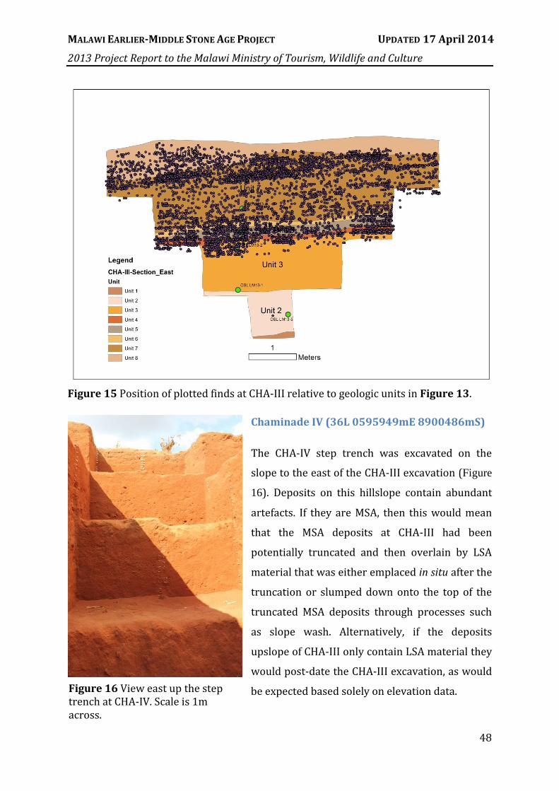
MALAWI EARLIER-MIDDLE STONE AGE PROJECT UPDATED 17 April 2014
2013 Project Report to the Malawi Ministry of Tourism, Wildlife and Culture
48
Figure 15 Position of plotted finds at CHA-III relative to geologic units in Figure 13.
Chaminade IV (36L 0595949mE 8900486mS)
The CHA-IV step trench was excavated on the
slope to the east of the CHA-III excavation (Figure
16). Deposits on this hillslope contain abundant
artefacts. If they are MSA, then this would mean
that the MSA deposits at CHA-III had been
potentially truncated and then overlain by LSA
material that was either emplaced in situ after the
truncation or slumped down onto the top of the
truncated MSA deposits through processes such
as slope wash. Alternatively, if the deposits
upslope of CHA-III only contain LSA material they
would post-date the CHA-III excavation, as would
be expected based solely on elevation data. Figure 16 View east up the step trench at CHA-IV. Scale is 1m across.

MALAWI EARLIER-MIDDLE STONE AGE PROJECT UPDATED 17 April 2014
2013 Project Report to the Malawi Ministry of Tourism, Wildlife and Culture
49
A six-metre trench running upslope was excavated to a maximum depth of ca. 2m
(Figure 17). As with CHA-III there was an initial concentration of artefacts at the top that
was then followed by a diffuse zone and then a series of laminar deposits. Further
details of site formation at CHA-IV are provided in Section V and Appendix 1.
Figure 17 Configuration of the north profile of the final exposed section at CHA-IV with plotted finds mapped against the profile.
Bruce (36L 0596563mE 8900830mS)
In the 1960s and 1970s J.D. Clark and his students located several significant
archaeological sites in Karonga. One of these, referred to by Clark as Chaminade 1A (Ch-
1a), yielded an assemblage of over 25,000 stone artefacts and several specimens of
worked ochre from an in situ deposit (Clark et al. 1970). However, the site was never
absolutely dated, the ochre and stone artefact assemblages were never thoroughly
analysed, and in the years since Clark’s excavation, the site’s exact location was lost. The
discovery of the CS-70 (“Bruce”) site over the course of the 2012 Chaminade surveys
may have resolved the final problem (Thompson et al. 2013a). A hand-annotated map
of the Clark and Haynes excavations was obtained and scanned from C.V. Haynes at the
University of Arizona, georectified into the MEMSAP GIS, and then compared against

MALAWI EARLIER-MIDDLE STONE AGE PROJECT UPDATED 17 April 2014
2013 Project Report to the Malawi Ministry of Tourism, Wildlife and Culture
50
other data held in that GIS (e.g. MEMSAP excavations, geologic units, etc.). When
MEMSAP test pits are compared against the locations of the original Clark excavations, it
was noted that several similar localities have been marked as deserving investigation by
both groups (Figure 18).
Figure 18 Digitised map of hand-annotated sites from materials held by C.V. Haynes (green stars) superimposed on digitised geological maps (Plc is the Chitimwe Beds) and with MEMSAP sites identified with yellow circles (CS stands for “Chaminade Survey” and refers to Test Pits excavated in 2012). Green stars with blue circles around them represent Clark’s sites with a 100m buffer around them to compensate for the lack of precision in older maps. Note the proximity of Clark’s Ch-1a to our Bruce, Ch-3 to our TP8, and Ch-2 to our TP12.
The Bruce site surface exhibited a depression suggestive of a previous excavation, with
mounds that may represent spoil heaps from the 1965 excavations and large numbers
of surface artefacts and some modified ochre pieces that generally match the original
assemblage description. Images of the site during excavation in 1965 (provided from
the archives at the Stone Age Institute by K. Schick and N. Toth) show a skyline that
compares favourably to the modern skyline, showing that it is overlooking the North
Rukuru from the correct perspective. Finally, after showing the site to W. Magumbwa

MALAWI EARLIER-MIDDLE STONE AGE PROJECT UPDATED 17 April 2014
2013 Project Report to the Malawi Ministry of Tourism, Wildlife and Culture
51
from the Cultural and Museum Centre Karonga in 2012, he confirmed that he used to
shortcut through this place as a boy while excavations were ongoing.
In 2013 excavations continued more deeply
in three 1 x 2m Areas (Area I, Area II, and
Area III), with Area I extended to a 1 x 3m
trench. Latrine pits newly dug for a nearby
house had been mapped and sampled in
2012, and two test pits dug in 2012 (Test
Pit 20 and Test Pit 21) were re-exhumed
and sampled in 2013 (Figure 19). Across
the site the majority of excavated finds
were located within the lower ~20cm of an
upper alluvial unit. These upper deposits
have been extensively altered by
agriculture, water erosion, and dumping.
A large surface depression scattered with
thousands of artefacts is suggestive of the
location of the original 1965 excavations.
The 1965 excavation plan was digitised
onto the depression and oriented as per the
archival photographs and does in fact
match up well to the depression (Figure
20). GIS was useful at the Bruce site for
Figure 19 Google Earth satellite image (October 2012) showing locations of excavations, interpolated elevations, excavation Areas (yellow), Test Pits (green), surface collection area (orange), and latrine pits (purple). The spring is indicated in blue.
Figure 20 Potential location of the original 1965 excavations relative to MEMSAP excavations.

MALAWI EARLIER-MIDDLE STONE AGE PROJECT UPDATED 17 April 2014
2013 Project Report to the Malawi Ministry of Tourism, Wildlife and Culture
52
palaeosurface modelling. Elevation points were taken at the top of fluvial facies exposed
in test pit and excavation profiles, and then used to interpolate a surface representing
those buried facies across the site. This was useful for illustrating the thickness of
artefact-bearing alluvium across a profile (Figure 21, profile taken across the white line
shown in Figure 19). In addition to predicting the depths at which artefacts should be
found, this is useful for understanding the potential for postdepositional movement of
artefacts along a slope. The data also allow linkage to more regional-scale depositional
processes by reconstructing the palaeoslope of more energetic facies of the Chitimwe
Beds where they grade down to the North Rukuru River.
Figure 21 85m profile along the white line in Figure 19 showing sample intervals with surface and subsurface topography. Details of the geoarchaeological context of the three Bruce excavations can be found in
Section V and Appendix 1. A useful way to examine site formation processes is to map
plotted finds against georectified sediment profiles to see where concentrations lie. At
the three Bruce excavation Areas this has revealed some consistent patterning in the
uppermost units.
At Area II, the east profile shows a mound of overlying deposit that has been preserved
by a tree stump in the face of the serious erosion that has scoured the area to the east.
Within this profile, there is a clear concentration of artefacts at and immediately above
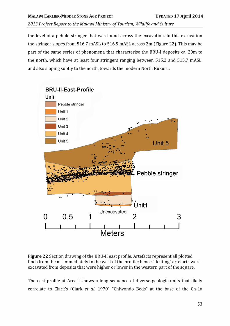
MALAWI EARLIER-MIDDLE STONE AGE PROJECT UPDATED 17 April 2014
2013 Project Report to the Malawi Ministry of Tourism, Wildlife and Culture
53
the level of a pebble stringer that was found across the excavation. In this excavation
the stringer slopes from 516.7 mASL to 516.5 mASL across 2m (Figure 22). This may be
part of the same series of phenomena that characterise the BRU-I deposits ca. 20m to
the north, which have at least four stringers ranging between 515.2 and 515.7 mASL,
and also sloping subtly to the north, towards the modern North Rukuru.
Figure 22 Section drawing of the BRU-II east profile. Artefacts represent all plotted finds from the m2 immediately to the west of the profile; hence “floating” artefacts were excavated from deposits that were higher or lower in the western part of the square.
The east profile at Area I shows a long sequence of diverse geologic units that likely
correlate to Clark’s (Clark et al. 1970) “Chiwondo Beds” at the base of the Ch-1a

MALAWI EARLIER-MIDDLE STONE AGE PROJECT UPDATED 17 April 2014
2013 Project Report to the Malawi Ministry of Tourism, Wildlife and Culture
54
excavation. There is a clear concentration of artefacts at the surface of the deposit; these
correspond to the large drape of surface artefacts present across the site (Thompson et
al. 2013a). The series of pebble stringers in Units 6 – 9 have been subjected to
preliminary pIR-IRSL feldspar analysis, which is a potential alternative to the
application of OSL to dating quartz (Figure 23). These ages presented here include both
EBS (Early Background Subtraction) and LBS (Late Background Subtraction) estimates.
Although these ages should not be taken as final estimates, they do suggest that alluvial
fan formation in the area began prior to ca. 100 ka, and possibly even ca. 200 ka. This is
consistent with other observations from the types of artefacts found in the area.
Figure 23 Section drawing of the BRU-I east profile. Artefacts represent all plotted finds from the m2 immediately to the west of the profile; hence “floating” artefacts were excavated from deposits that were higher or lower in the western part of the square.

MALAWI EARLIER-MIDDLE STONE AGE PROJECT UPDATED 17 April 2014
2013 Project Report to the Malawi Ministry of Tourism, Wildlife and Culture
55
The heavy erosion in the area is apparent in the shapes of the section drawings, which
show at least one eroded and/or slumped aspect. The Area III excavation was emplaced
to avoid this problem, and provide a “top-down stratigraphy” that is representative of
the site (Figure 24). However, excavation revealed major differences in site formation at
BRU-III from the other excavation areas, including episodes of carbonate formation.
Artefact concentrations are also not as informative here, instead suggesting a very
recent winnowing effect at the surface followed by diffuse artefact deposition uniformly
throughout the underlying units.
Figure 24 Section drawing of the BRU-I south profile. Artefacts represent all plotted finds from the m2 immediately to the west of the profile; hence “floating” artefacts were excavated from deposits that were in the northern part of the square.
MALAWI EARLIER-MIDDLE STONE AGE PROJECT UPDATED 17 April 2014
2013 Project Report to the Malawi Ministry of Tourism, Wildlife and Culture
56
V. SITE-SCALE GEOARCHAEOLOGY
Introduction
Geoarchaeological observations at the site scale include descriptions of sediment
profiles, mapping, sampling for geochronology and micromorphology, and overall
interpretations of site formation processes. Macroscopic site-scale geoarchaeology is
led by Dr David Wright, whilst the Tübingen geoarchaeology team applies
micromorphology and other micro-analytical techniques to the study of archaeological
sediments and soils. Both aspects of the work are designed to reconstruct site formation
histories and past human environments. In 2013, Flora Schilt carried out field work in
Karonga for about one month (July 8th to August 4th), and Christopher Miller arrived on
the 24th of July together with Dr David Wright (Seoul National University) and Dr
Jeong-Heon Choi (Korea Basic Science Institute). The entire team departed on August
4th. Most geoarchaeological field work, such as sample collection and describing
profiles, was carried out during the last 1.5 weeks of field work, as close collaboration
between the different specialists was necessary.
Descriptions of sediment profiles are given in Appendix 1. Miller and Schilt collected 30
micromorphological block samples with correlating loose samples, 2 ground water
samples for stable oxygen and hydrogen isotopic analysis and 7 carbonate nodules for
stable carbon and oxygen isotopic analyses and uranium-series dating (Table 3). In
addition to describing and sampling the archaeological profiles, several exposed profiles
in the North Rukuru drainage were also studied to provide regional context.
The goal of the site-scale work is to understand how cultural materials were deposited
and then potentially reworked through post-depositional processes, to aid in
reconstructions of the timing and processes active on the local landscapes in which
artefacts are found, and to develop independent palaeoenvironmental proxies that can
be compared with palaeoclimatological data obtained from sediment cores collected in
Lake Malawi (Scholz et al. 2011). Micro-analytical techniques also provide important
contextual information for the interpretation of luminescence dating methods.
MALAWI EARLIER-MIDDLE STONE AGE PROJECT UPDATED 17 April 2014
2013 Project Report to the Malawi Ministry of Tourism, Wildlife and Culture
57
Table 3 All sites sampled, number of samples collected, number of samples processed, and years in which samples were collected.
Sites # of samples # of samples
processed
Years collected
Test pit near MGD I 3 3 2010
MGD I 13 11 2011, 2012
MGD I extra loose samples 6 0
MGD II 4 4 2011
MGD III 6 6 2011, 2012
Water samples: MGD and Bruce
springs, Mwakasungura water
pump
3 0 2012, 2013
CHA I 3 0 2011, 2013
CHA II 7 5 2012
CHA III 5 0 2013
CHA IV 2 0 2013
Bruce septic tank 1 1 2012
BRU I 4 0 2013
BRU II 2 0 2013
BRU III 4 0 2013
BRU III CaCO3 nodules 7 0 2013
BRU-WELL 1 0 2013
Test Pits 1,2,3,7,8,9,11,19,21,&
20
16 0 2012, 2013
Sadala South 1 0 2012
APS (Airport Site) 1 1 2010
KRW (Kafula Ridge West) 1 1 2010
NRK (North Rukuru River
Terrace)
1 0 2013
KCR (Karonga-Chitipa Road) 2 0 2013
MAL (Malema Chiwondo) 1 0 2013
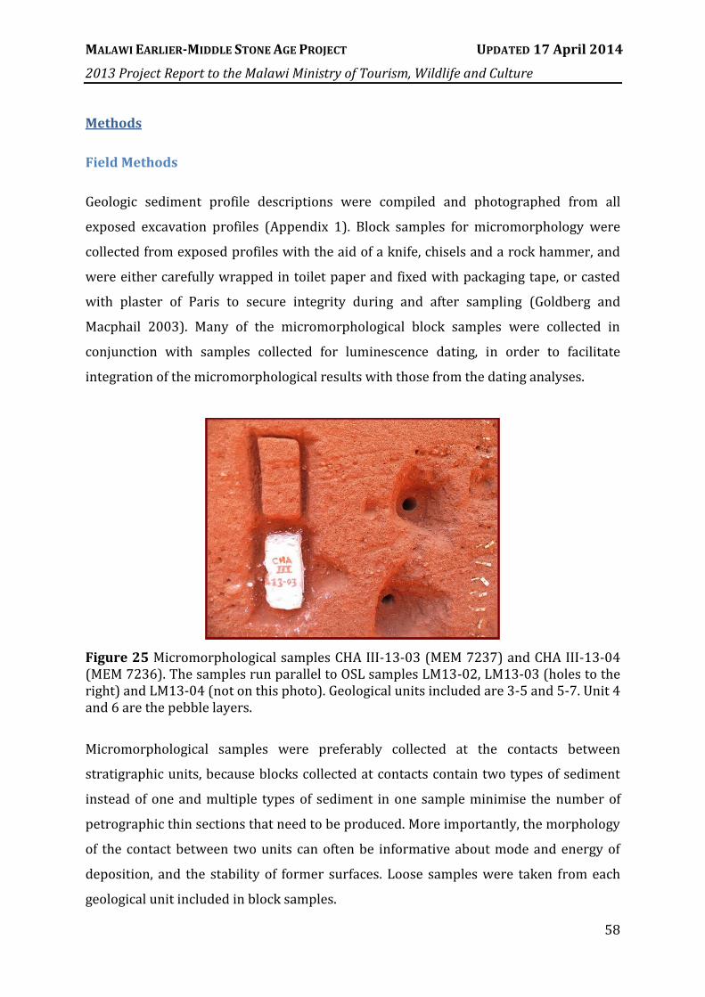
MALAWI EARLIER-MIDDLE STONE AGE PROJECT UPDATED 17 April 2014
2013 Project Report to the Malawi Ministry of Tourism, Wildlife and Culture
58
Methods
Field Methods
Geologic sediment profile descriptions were compiled and photographed from all
exposed excavation profiles (Appendix 1). Block samples for micromorphology were
collected from exposed profiles with the aid of a knife, chisels and a rock hammer, and
were either carefully wrapped in toilet paper and fixed with packaging tape, or casted
with plaster of Paris to secure integrity during and after sampling (Goldberg and
Macphail 2003). Many of the micromorphological block samples were collected in
conjunction with samples collected for luminescence dating, in order to facilitate
integration of the micromorphological results with those from the dating analyses.
Figure 25 Micromorphological samples CHA III-13-03 (MEM 7237) and CHA III-13-04 (MEM 7236). The samples run parallel to OSL samples LM13-02, LM13-03 (holes to the right) and LM13-04 (not on this photo). Geological units included are 3-5 and 5-7. Unit 4 and 6 are the pebble layers.
Micromorphological samples were preferably collected at the contacts between
stratigraphic units, because blocks collected at contacts contain two types of sediment
instead of one and multiple types of sediment in one sample minimise the number of
petrographic thin sections that need to be produced. More importantly, the morphology
of the contact between two units can often be informative about mode and energy of
deposition, and the stability of former surfaces. Loose samples were taken from each
geological unit included in block samples.

MALAWI EARLIER-MIDDLE STONE AGE PROJECT UPDATED 17 April 2014
2013 Project Report to the Malawi Ministry of Tourism, Wildlife and Culture
59
At the Bruce Area III site, carbonate nodules were collected for uranium series and
stable carbon and oxygen isotopic measurements. The orientations of the nodules were
marked on top with red nail polish after which they were carefully wrapped in toilet
paper and fixed with packaging tape.
Micromorphology
Micromorphology is the study of oriented blocks of intact sediment in thin section using
a petrographic microscope. The thin sections are studied under plane polarised light
(PPL), crossed polarised light (XPL), blue light fluorescence, and oblique incident light
(OIL) (Courty et al. 1989). From the analyses of the composition and fabric (geometry of
the components, both solids and voids) of sediments and soils, interpretations can be
made about the processes responsible for their formation and post-depositional
modification. Thin section analysis allows the sampling and study of sediments and soils
of all types (geogenic, biogenic, and anthropogenic) using the same methods.
The micromorphological samples collected during field work in Karonga are being
processed at the Institute for Archaeological Sciences (Institut für
Naturwissenschaftliche Archäologie - INA) in Tübingen, Germany. Block samples are
oven-dried at 60°C for several days and impregnated with polyester resin under
vacuum. The resin is prepared with 7 volume units of polyester resin (Viscovoss N 55S),
3 volume units of styrene (styrene for synthesis) and 5-6 ml/l hardener (MEKP). After
hardening, the samples are cut into slabs from which, depending on the size of the
sample and sample objectives, up to three uncovered 60x90mm thin-sections of 30
micron thickness are produced. Micromorphological description and analysis are
performed following the criteria outlined by Courty et al. (1989) and Stoops et al.
(2003). Based on field observations and results from thin section analysis, other
analyses such as particle size analysis and Fourier Transform Infrared Spectroscopy
(FTIR) will be performed on the loose samples.
Methods that we plan to apply in the near future include stable isotopic measurements
(δ18O, δ13C) and uranium-series (234U-230Th) dating of secondary carbonates. In 2012
and 2013, loose samples of secondary carbonates were collected from several

MALAWI EARLIER-MIDDLE STONE AGE PROJECT UPDATED 17 April 2014
2013 Project Report to the Malawi Ministry of Tourism, Wildlife and Culture
60
archaeological and geological trenches located in different areas of the Karonga
palaeolandscape (Mwanganda’s Village I and III, Test Pits 2 and 11, Bruce III). Stable
carbon and oxygen isotope analysis provides information about past climate and
vegetation, while measurements of isotopes in the uranium decay series can provide
absolute ages for the formation of the carbonates. Stable carbon and oxygen isotope
measurements will be executed on some of the collected loose samples, as well as on
samples of carbonates from micromorphological blocks using methods outlined in
Mentzer and Quade (Mentzer and Quade 2013), to directly link isotopic ratios to the
micromorphological observations of secondary carbonates. Measurements of stable
carbon and oxygen isotopic ratios will be conducted by Dr. Heinrich Taubald in the
Isotope Geochemistry laboratory at the University of Tübingen. Prior to conducting
stable carbon and oxygen isotopic measurements or uranium-series dating, carbonate
nodules will be examined in polished cross section using petrographic and
cathodoluminescence microscopes to assess any potential recrystallization that may
have taken place. Loose samples of secondary carbonates will be directly dated using
the 234U-230Th disequilibrium method. The samples will be prepared at the University of
Tübingen, and analysed in the School of Earth Sciences at the University of Queensland,
Australia by Prof. Jian-xin Zhao and Dr. Gilbert Price. Funds for this work have been
requested in a grant to the German Research Foundation (DFG).
Summary of Site Observations
Chaminade III
It was suggested by Dr Wright that dm-scale redox features could be an indication for
rodent activity, because the looser material in burrows, compared to the surrounding
matrix, would have been more susceptible to redoximorphy. The occurrence of large
gravel pockets is most likely also related to burrowing activities, however by a bigger
animal such as ground pangolin (Manis temminckii) or aardvark (Orycteropus afer).
From field observations it therefore follows that the sediments in Chaminade Area III
have been strongly disturbed by burrowing animals, which may be a factor in the
laminar deposition of the artefacts noted in Section IV. After the profile was studied,
discussed and described, five micromorphological samples were collected. The
micromorphological block samples will be used to determine the depositional

MALAWI EARLIER-MIDDLE STONE AGE PROJECT UPDATED 17 April 2014
2013 Project Report to the Malawi Ministry of Tourism, Wildlife and Culture
61
formation of the units. The formation of the units containing larger amounts of artefacts
is of the most interest, for example the gravelly units in which microliths could be easily
recognised in the profile. Also, analyses will focus on the post-depositional alterations of
the sediments, including bioturbation, in order to determine what processes may have
influenced the archaeological record and to what extent. As in most other cases,
micromorphological samples were collected parallel to, or at least from the same units
as, OSL samples to provide information for the interpretation of the dating results. The
extension of CHA III (Squares D98 to D94) was also excavated during the 2013 field
season. It was sampled for OSL at the end of the field season but not for
micromorphology.
Chaminde IV
Chaminade IV (CHA-IV) is located on the steep western slope of a ridge associated with
alluvial fan deposits (Figure 26d). The area excavated had not (recently) been worked
by farmers and was protected by trees. However, the area is surrounded by agricultural
fields. The excavation yielded abundant stone artefacts, but the sediments of the upper
ca. meter were strongly bioturbated by termite activity and large roots. The excavated
sediments consisted of slope colluvium and it is expected that undisturbed deposits lie
deeper and have not yet been reached. In the profile, immediately below the topsoil, an
alternation of greyish sediments and more reddish reworked lateritic sediments of
similar texture could be observed. These two distinct facies probably formed by burning
of nearby fields by farmers as a preparation before planting (Figure 26a). When
followed by rain, the burnt sediment from the barren fields would have washed down
and become deposited on the slope side as colluvium. A micromorphological sample
was collected from the alternating beds to test our interpretation based on macroscopic
field observations. A second sample was collected from the sediments higher up in the
profile as a reference sample for modern ant activity (Figure 26a, b).

MALAWI EARLIER-MIDDLE STONE AGE PROJECT UPDATED 17 April 2014
2013 Project Report to the Malawi Ministry of Tourism, Wildlife and Culture
62
Figure 26 Chaminade IV a) collection of a sample from dm-scale alternating beds of burned (grey) sediments and unburned reworked lateritic sediment. b) collection of a sample with known current ant activity in surficial sediments for reference. c) overview photo from CHA IV towards the west. d) overview of the hill before excavations at CHA IV were initiated. View to the north-northeast.
Bruce
Test Pits 20 and 21 were excavated in August 2012 and re-exposed in 2013 for profile
description and sample collection. Test Pit 20 is located next to a house on an alluvial
ridge and consists predominantly of sandy deposits. One micromorphological sample
was collected nearby in 2012 from one of the trenches that were dug for the septic tank
system of the house. In 2013, we collected four micromorphological samples from Test
Pit 20 that comprise the geological units 1-6 (Figure 27). These samples provide data on
the deposition of MSA artefact-bearing deposits upslope of the main Bruce site.
Abundant sharp-edged artefacts were discovered at >2m depth in 2012, mainly
concentrated within ca. vertical 20cm of one another. Hundreds of artefacts had also
been exhumed by the person digging the latrine pits in 2012, and these were scattered
across the surface. However, the continued presence of artefacts at this depth in TP20
bodes well for the preservation of additional buried and intact deposit here.

MALAWI EARLIER-MIDDLE STONE AGE PROJECT UPDATED 17 April 2014
2013 Project Report to the Malawi Ministry of Tourism, Wildlife and Culture
63
Figure 27 Test Pit 20; a) Overview to the south-west; b) Profile of TP 20 after OSL sampling but before collection of micromorphological samples; c) During sample collection. TP 20-13-13 and TP 20-13-14.
Test Pit 21 is located downslope and to the north-
west of TP 20. It contained lagoonal, clay-rich
deposits with a 5 cm thick layer of fine gravel near
the base (Figure 28). The vertical surface of the
profile had termite channels running over it, and
was strongly reddened since exposure and covered
with salts (Figure 28). This showed us not only how
quickly termites build their channels over a freshly
exposed profile-surface but also how over the
course of only a couple of weeks the fresh surface of
a profile can become weathered and oxidised,
changing its colour from greyish to red shades.
After scraping clean a column, the profile was
described. Three micromorphological samples were
collected. They include the units 1, 2, 3, 5 and 6.
Bruce Area I (BRU I) is located immediately east of a series of exposed channel bed
sequences. In 2012, four OSL samples were collected from this eroded exposure before
the area was further excavated (Figure 29).
Figure 28 Bottom part of Test Pit 21 (N-profile), showing the lower part of the profile. Note gravel layer at ca. 15 cm from the bottom, termite channels, and colour difference after scraping off the oxidised profile surface.

MALAWI EARLIER-MIDDLE STONE AGE PROJECT UPDATED 17 April 2014
2013 Project Report to the Malawi Ministry of Tourism, Wildlife and Culture
64
Figure 29 a) Bruce Area I, showing channel beds exposed from erosion on the left and a channel bed sequence in the excavated area to the right. b) Lowermost part of E-profile, showing a clayey intraclast inside cm-scale beds of coarse sand and fine gravel).
In the second lowermost unit of the excavation (10-45 cm from the bottom), clayey
intraclasts were observed (Figure 29b). These intraclasts could be the result of rodent
burrowing. While bedding features in this unit and the sequence of gravelly bedding
structures just above it indicates that no major post-depositional mixing has taken
place, the intraclasts suggest that at least some bioturbation occurred in this lower part
of the profile. However, only a few plotted finds were found in this excavation area,
especially below the gravel beddings, and these are yet to be confirmed as artefacts. An
assessment of the extent and nature of post-depositional disturbances at Bruce Area I is
therefore not only necessary to reconstruct the natural and anthropogenic influences on
the distribution of artefacts, but more importantly for the interpretation of results from
OSL dating.
In thin section more information will be gathered about the formation of features such
as the macroscopically observed intraclasts and how they may have impacted the
archaeological record. In the lower and especially the middle part of the profile the
intact channel bed sequences indicate that overall bioturbation was minimal. The units
above the gravelly channel beds, however, appear considerably impacted by
bioturbation. We collected three micromorphological samples from the bedded units
and one from the transition of unit 8 to the more bioturbated uppermost unit 9. These
samples will allow us to compare post-depositional mixing in the different units and
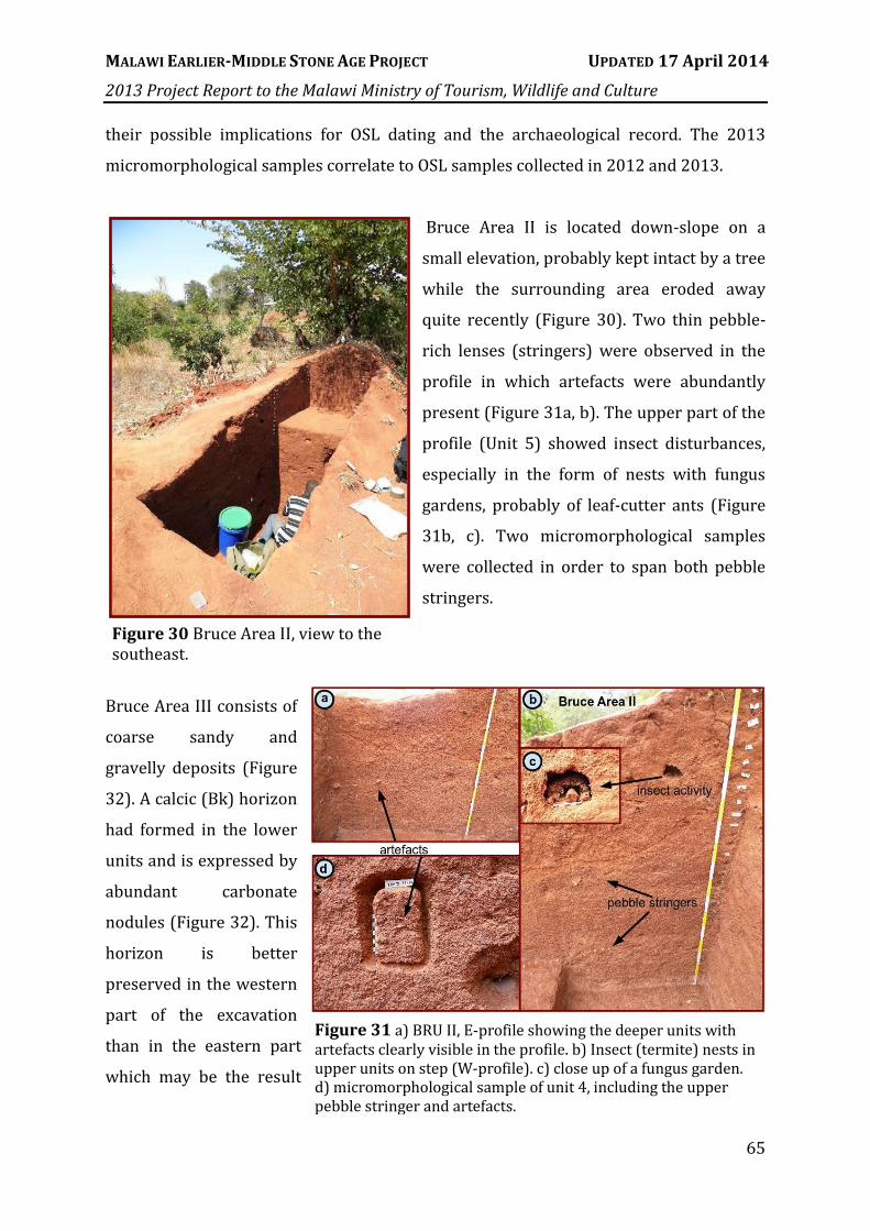
MALAWI EARLIER-MIDDLE STONE AGE PROJECT UPDATED 17 April 2014
2013 Project Report to the Malawi Ministry of Tourism, Wildlife and Culture
65
their possible implications for OSL dating and the archaeological record. The 2013
micromorphological samples correlate to OSL samples collected in 2012 and 2013.
Bruce Area II is located down-slope on a
small elevation, probably kept intact by a tree
while the surrounding area eroded away
quite recently (Figure 30). Two thin pebble-
rich lenses (stringers) were observed in the
profile in which artefacts were abundantly
present (Figure 31a, b). The upper part of the
profile (Unit 5) showed insect disturbances,
especially in the form of nests with fungus
gardens, probably of leaf-cutter ants (Figure
31b, c). Two micromorphological samples
were collected in order to span both pebble
stringers.
Bruce Area III consists of
coarse sandy and
gravelly deposits (Figure
32). A calcic (Bk) horizon
had formed in the lower
units and is expressed by
abundant carbonate
nodules (Figure 32). This
horizon is better
preserved in the western
part of the excavation
than in the eastern part
which may be the result
Figure 30 Bruce Area II, view to the southeast.
Figure 31 a) BRU II, E-profile showing the deeper units with artefacts clearly visible in the profile. b) Insect (termite) nests in upper units on step (W-profile). c) close up of a fungus garden. d) micromorphological sample of unit 4, including the upper pebble stringer and artefacts.

MALAWI EARLIER-MIDDLE STONE AGE PROJECT UPDATED 17 April 2014
2013 Project Report to the Malawi Ministry of Tourism, Wildlife and Culture
66
of differential decalcification throughout the solum. This can be determined with
micromorphology, because decalcification features are easily recognised in thin section.
We collected three micromorphological samples in Bruce Area III that will help us to
reconstruct the site formation processes and differences in soil formation.
Figure 32 South-west corner of Bruce Area III. Collection of micromorphological samples and carbonate nodules for U-series dating and stable isotope analysis.
It is expected that the calcic horizon formed in place as a result of weathering. In that
case the horizon is an indication for a former stable landscape when the climate was
more arid than today. Artefacts deposited inside and on top of this calcic horizon could
be linked to this ancient land surface. Isotopic analyses and uranium series dating
performed on the sampled carbonate nodules will provide information about their age
and the environment during their formation. Outcrops of similar secondary carbonates
can be observed in Mwanganda’s Village as well as near the Bruce excavations (Figure
33). It is possible that the carbonates in both areas formed during the same period, but
this relationship cannot be confirmed until the exact nature of the nodules in both areas

MALAWI EARLIER-MIDDLE STONE AGE PROJECT UPDATED 17 April 2014
2013 Project Report to the Malawi Ministry of Tourism, Wildlife and Culture
67
has been studied. It is possible that not all of the secondary carbonates are strictly
pedogenic in origin. Fluctuations in groundwater level occur in the study area and can
lead to similar carbonate formations.
Figure 33 Secondary carbonates (brackets) crop out in the area of the Bruce excavations and near the excavations in Mwanganda’s Village. At Mwanganda’s Village, carbonate as well as water samples were collected in 2012 for reference when performing isotopic analysis. Elevations were measured at localities where carbonates outcropped.
North Rukuru (Terrace 1)
One of the goals of the broader geoarchaeological study is to reconstruct and date
different stages of landscape development in the Karonga area. An important step in
achieving this goal is understanding the drainage system. At the North Rukuru River,
the southern fluvial cut bank (Terrace 1) was described and sampled (Figure 34).
Figure 34 North Rukuru river (left) and cut bank (right).

MALAWI EARLIER-MIDDLE STONE AGE PROJECT UPDATED 17 April 2014
2013 Project Report to the Malawi Ministry of Tourism, Wildlife and Culture
68
Karonga-Chitipa Road (Terrace 2)
At a crossing between a minor dirt road and the main Karonga-Chitipa road, a man was
digging a new latrine in front of his house, located on the second terrace of the North
Rukuru River. He allowed us to describe the profile in the latrine pit and collect samples
for OSL and micromorphology. We collected two small samples for micromorphology:
one in the upper part of a B-horizon and one in the C-horizon of a soil formed in a
profile consisting of sandy clay loam (Figure 35).
Malema
Malema camp is located ca. 10 km south of
Karonga, where Chiwondo Beds outcrop over
a large area. The camp was initially built to
accommodate researchers and excavators
involved in palaeontological research. The
team visited the area to observe and
document the Chiwondo Beds and compare
them with Chiwondo deposits exposed in the
MEMSAP excavations. No samples were taken.
Chaminade I
Miller and Schilt revisited Chaminade I to collect a small micromorphological sample of
a unit containing abundant Fe/Mn nodules, as well as a large loose sample from the
same unit (Unit 5). The objective in collecting these samples is to compare the nodules
in thin section with nodules from other sites (CHA-II, APS and TP9) and to determine
whether they formed in situ (orthic nodules) or derive from elsewhere (disorthic). It is
possible that these nodules originally formed higher up in the profile and were moved
downwards by insect activity (Crossley 1986). We can determine this by conducting
Figure 35 Profile of the Karonga-Chitipa Road site.

MALAWI EARLIER-MIDDLE STONE AGE PROJECT UPDATED 17 April 2014
2013 Project Report to the Malawi Ministry of Tourism, Wildlife and Culture
69
particle size analysis on both the sand grains present within the nodules after Fe/Mn
extraction, and on the surrounding matrix sediments. Comparison of the textures will
help us understand the relationship between the nodules and their present matrix. Iron
and manganese can be removed with sodium dithionite, sodium citrate or comparable
reducing agents. Sequestering agents, such as oxalic acid or citric acid, can also be used
for this. Differentiating these processes is important because the artefact assemblage
from CHA-I has now been analysed and refitted, and OSL ages have been finalised that
are currently being prepared for publication (Figure 36).
Figure 36 Profile of the CHA-I site with OSL ages indicated
Preliminary Micromorphology Results
Preliminary thin section analyses have focused on samples collected from three
excavations at the site of Mwanganda's Village: Area I, a 2010 test pit near Area I and
Area III. The results of these preliminary analyses suggest that depositional and post-
depositional processes in the Chitimwe beds are complex and best addressed through
micromorphology. For example, we have identified vertical and horizontal variation in
pedogenic and groundwater-related processes, including gleying and other redox
processes, bioturbation caused by termites, authigenic carbonate formation, clay

MALAWI EARLIER-MIDDLE STONE AGE PROJECT UPDATED 17 April 2014
2013 Project Report to the Malawi Ministry of Tourism, Wildlife and Culture
70
translocation, and secondary silicate formation. Importantly, micromorphological
analyses show that many of the microscopic features associated with different
pedological processes overlap one another (Figure 37). For example, the superposition
of secondary carbonates over redoximorphic features and silica coatings on carbonate
nodules provide direct evidence for diachronic variation in soil forming processes.
Figure 37 Photomicrographs of soil thin sections from Mwanganda’s Village Area I. The features observed in these thin sections show clear evidence for changing soil processes which are likely related to changing environmental conditions. A) q—quartz grain, cc—secondary carbonate nodule, ss—secondary silicates that overprints the secondary carbonate. PPL. B) I—iron staining (other abbreviations same as is A). Here, secondary silica overprints secondary iron staining. PPL. C) c—clay coatings; same abbreviations as before. The iron staining overprints clay coatings. PPL.

MALAWI EARLIER-MIDDLE STONE AGE PROJECT UPDATED 17 April 2014
2013 Project Report to the Malawi Ministry of Tourism, Wildlife and Culture
71
VI. OCHRE ANALYSIS
Overview
One of the ongoing research projects subsumed within MEMSAP is the investigation of
ochre pigments present in MSA archaeological sites in the Karonga area. Such pigments
have been linked by many authors to the origins of symbolism in the human lineage,
especially material symbolism associated with the suite of activities which constitute
recognisably modern behavior (Watts 2010, Henshilwood et al. 2009, McDougall et al.
2005, Barham 2002, McBrearty and Brooks 2000). Previous studies of ochre pigment
have largely emphasized South African MSA sites such as Pinnacle Point 13B (Watts
2010, Marean et al. 2007) and Blombos Cave (Henshilwood et al. 2011, Henshilwood et
al. 2009, Henshilwood et al. 2002). Examples of MSA ochre from elsewhere in Africa,
such as that found in the Kapthurin Formation at Baringo, Kenya (Deino and McBrearty
2002) are incompletely published or occur as residues on lithic tools which are not
suitable for provenance studies using current technology (Mercader et al. 2009). The
only site in Central Africa at which ochre pigment has been excavated and studied using
modern methods is Twin Rivers, Zambia (Barham 2000, Barham 2002, Barham 1998).
MEMSAP research in northern Malawi provides an opportunity to fill an important
geographic gap in our understanding of how the MSA varies across sub-Saharan Africa.
This avenue of investigation has been pursued since 2011 and focuses on the formation
mechanisms, distribution on the landscape, collection criteria used by MSA humans,
transport distances, and modification strategies relevant to ochre pigments.
Methods
In 2011 ochre source identification and sampling fieldwork was undertaken by Andrew
Zipkin during the MEMSAP field season from July through August. The range of
geological processes associated with the term ochre is considerable; mostly due to the
range of materials that fall under that umbrella label. Ochres are generally alteration or
weathering products of iron ores, sulphide minerals, or other iron-rich rocks (Harben
and Kužvart 1996). Common accessory minerals in ochre include quartz and other
silicate minerals, hydrous aluminum phyllosilicates (clays), micas, carbonates,

MALAWI EARLIER-MIDDLE STONE AGE PROJECT UPDATED 17 April 2014
2013 Project Report to the Malawi Ministry of Tourism, Wildlife and Culture
72
evaporites, and organic matter (Green and Watling 2007, Watts 2002). As a
consequence of this diversity, identifying which rocks and minerals to treat as ochre
was a considerable challenge. For the purposes of this project, red and orange colored
lateritic soils were not treated as a viable source of ochre pigment unless such material
was found as a lens or bed within a sedimentary formation as opposed to exposed on
the modern land surface. Emphasis was placed on sampling sources of ochreous rocks
and minerals that occur as discrete point sources (lenses of ochreous clay accessible at
an exposure) or as discrete objects (ochreous mudstone cobbles available in river beds).
Ochre sources in northern Malawi generally exhibit complex mineralogy due to their
sedimentary nature. Unlike ochres found in association with vein quartz and
predominantly composed of hematite, such as those found near Twin Rivers, Zambia,
much of the ochre in Malawi is a mixture of weathering products that have been eroded,
transported, and deposited. Such ochres present a challenge for provenance studies
because they represent the blending of the geochemical fingerprints of multiple rock
formations.
Figure 38 Locations of ochre sources used in geochemical analysis.

MALAWI EARLIER-MIDDLE STONE AGE PROJECT UPDATED 17 April 2014
2013 Project Report to the Malawi Ministry of Tourism, Wildlife and Culture
73
Several sources were identified during the 2011 season but the three most thoroughly
sampled were chosen for geochemical analysis (Figure 38). Multiple samples were
collected from each source in order to determine the maximum amount of intra-source
variability, with particular attention paid to acquiring ochre from different depths
within a deposit and representing different colors of ochre when applicable. The
Malema Camp source is a band of poorly lithified yellow-orange sandy silt within the
Chiwondo Beds accessible at a stream-cut exposure. The Mulowe River near Mutowa
Village source is a lithic polymict orthoconglomerate containing siltstone, claystone,
mudstone, and quartz framework clasts. Lastly, the Kayelekera Village source consists
of a shallow pit dug by local residents into the Karoo sandstone formation underlying
the soil. Between 50 and 70 cm depth, the pit consists of quartz-poor, poorly lithified,
clay and sand with mottled red, orange, yellow, and white colouration. Details regarding
these three sources may be found in Zipkin et al. (2014, in press), Table 1.
Results
Trace element composition of the ochre samples from these three sources was
determined using Instrumental Neutron Activation Analysis (INAA) performed at the
University of Missouri Research (MURR) Reactor and using Homogenized Ochre Chip
Laser Ablation Inductively Couple Plasma Mass Spectrometry (HOC LA-ICPMS). Both
methods were used in order to determine whether or not HOC LA-ICPMS is capable of
producing comparable results to a mature technique like INAA which has been used for
decades in archaeometric research. The HOC sample preparation method was first
developed by Green and Watling (2007) and has been further refined by Andrew Zipkin
and John M. Hanchar (Memorial University of Newfoundland, MUN) for the purpose of
allowing the analysis of ochre artefacts that are too large to fit into an ablation chamber
for direct analysis but also require minimally invasive techniques that limit damage. The
HOC technique entails extracting a small amount, potentially as little as 10 mg, of ochre
from an artefact by drilling and then diffusing the resulting powder into neutral pH
white glue. The resulting mixture is then dried into a solid film or chip and mounted for
ablation on an epoxy disk. When geological source samples are analysed, the ochre is
dehydrated in an oven and then homogenized using a mortar and pestle before mixing
with the glue. Due to the addition of the glue binder, the results of LA-ICPMS done on

MALAWI EARLIER-MIDDLE STONE AGE PROJECT UPDATED 17 April 2014
2013 Project Report to the Malawi Ministry of Tourism, Wildlife and Culture
74
HOCs cannot be considered absolute values for the composition of an ochre sample.
Rather, this technique is intended specifically for provenance studies where all samples
are analysed using the same method and relative compositional differences between
sources are sufficient for assigning artefacts to their deposit of origin. Zipkin et al. 2014
found that the trace element fingerprints obtained were robust enough that
multivariate statistical analysis was able to distinguish among sources and uphold the
Provenance Postulate for the three ochre sources considered. The ability to distinguish
among these sources was verified by the INAA results.
Since demonstrating that it is possible to distinguish among at least some of the
sedimentary pigment sources of northern Malawi, the ochre research turned its
attention to archaeological ochre artefacts. The artefacts excavated from the Chaminade
1A (Ch-1a) MSA site by J. Desmond Clark and Van Eggers in 1965 and 1966 are curated
at the Stone Age Institute (SAI) in Bloomington, Indiana, USA. The ochre from this
excavation was never completely published, but is potentially significant because of the
implications that material symbolism may have for the evolution of modern behaviour.
The Bruce site, which has been provisionally equated with the Ch-1a site (see Section
IV), yielded 18 pieces of red ochre on the surface, weighing a total of 134.1 g. Among the
eighteen pieces of surface ochre collected, eight pieces exhibit unambiguous evidence of
modification including convergent facets, flat ground surfaces, knapped flakes, and
incisions (Figure 39). The initial goals for the site included conducting new excavations
to determine if any undisturbed sediments remained, determining chronometric ages
for the site, and doing trace element composition analyses of any ochre artefacts found
on the surface, in the new excavations, and from the original Clark Ch-1a ochre.
Figure 39 Ground ochre plaque from Ch-1a (left) and two ground or incised ochre fragments from the surface of Bruce (right).

MALAWI EARLIER-MIDDLE STONE AGE PROJECT UPDATED 17 April 2014
2013 Project Report to the Malawi Ministry of Tourism, Wildlife and Culture
75
The ochre-specific research questions included the following:
Research Question 1: What is the elemental composition of the ochre artefacts from
CH-1A and Bruce and how variable is each assemblage?
Research Question 2: Is the collection of ochre artefacts excavated by J.D. Clark and
colleagues at Ch-1a of comparable trace element composition to the ochre collected on
the surface of the “Bruce” site by MEMSAP?
Research Question 3: Do the ochre artefacts from either assemblage show affinities to
present day ochre sources in northern Malawi?
In order to address these questions, during the 2012 field season the previously
mentioned ochre artefacts from the surface of the Bruce site were collected. Additional
ochre sources were sampled, with an emphasis on ochreous boulders and cobbles in
riverbeds throughout northern Malawi. Walking surveys of the Mkungwe tributary of
the North Rukuru, and of the Lufira, Ruasho, Wayi, and Remero Rivers were undertaken
by Andrew Zipkin. All rivers except the Remero yielded at least sporadic ochreous
cobbles and boulders, and more rarely, examples of bedrock exposures on the banks
weathering in situ into ochre. All source samples and the surface artefacts from Bruce
were exported to the United States for geochemical analysis; the surface artefacts will
be returned to Malawi in July 2014.
Since MEMSAP interest in archaeological ochre in the Karonga area was initiated by the
report of pigments at Ch-1a in Clark et al. (1970), the next logical step was to
incorporate this assemblage into the broader MEMSAP pigment sourcing project.
Andrew Zipkin traveled to SAI during late 2012 to describe and photograph the ochre
artefacts excavated from CH-1A in 1965 and 1966. Just over 2 kg of ochre artefacts were
identified in the SAI collection of which about 130 g were too fragile to sample.
Ultimately 14 artefacts were drilled to extract ochre powder for trace element analysis.
These samples, the Bruce surface artefacts, and the Malawi ochre sources samples from
the 2012 field season were prepared for LA-ICPMS using the HOC technique. Analyses
were carried out at MUN by Andrew Zipkin and John Hanchar during February 2013. In
addition to LA-ICPMS, each HOC was also analysed using Electron Microprobe Analysis

MALAWI EARLIER-MIDDLE STONE AGE PROJECT UPDATED 17 April 2014
2013 Project Report to the Malawi Ministry of Tourism, Wildlife and Culture
76
(EMPA) in order to measure iron content and use this element as an internal standard
for the purpose of transforming counts per second into ppm concentrations for trace
elements. EMPA was done at the University of Maryland by Dr. Phillip Piccoli in
collaboration with Andrew Zipkin.
The results of the LA-
ICPMS and EMPA analyses
of the ochre source and
artefact samples were
presented by Andrew
Zipkin at the bi-annual
meeting of the East African
Association for
Paleoanthrology and
Paleontology in Mombasa,
Kenya on July 31st, 2013.
The EMPA measures of iron
found that the all ochre
artefacts were relatively
low in Fe content, with none exceeding 30% (Figure 40). In addition, it was found that
the Clark Chaminade 1a ochre artefacts exhibited significantly (ANOVA: Bruce Surface ≠
Ch-1a (α = 0.05 p = 0.001) lower iron content than the Bruce surface collected artefacts.
This does not preclude the ochre artefacts from each assemblage being derived from the
same source since iron content can vary radically within a single ochre source.
Research question #1 was addressed using Upper Crust Normalized Spider Plots and
Chondrite Normalized Spider Plots to compare the artefacts in each assemblage (Figure
41). The two assemblages showed generally similar patterns of trace element
composition in the Upper Crust Normalized plots in which all elements measured by LA-
ICPMS were considered. All elements were depleted relative to the upper crust of the
earth with the exception of a few artefacts from CH-1A that were enriched in Nickel.
Both assemblages displayed a marked depletion of Strontium and a notably minor
depletion in Lead. In the Chondrite Normalized plots, only Rare Earth Elements (REEs)
Figure 40 Bruce surface artefacts Fe composition (left) compared to Fe composition in the Chaminade-1a artefacts (right). Left axis is %Fe (FeO + Fe2O3).

MALAWI EARLIER-MIDDLE STONE AGE PROJECT UPDATED 17 April 2014
2013 Project Report to the Malawi Ministry of Tourism, Wildlife and Culture
77
were plotted. All samples showed a progressive depletion of rare earth elements from
heavy to light elements, the only exception to the gradual decrease being marked
Cerium anomalies, both positive and negative, relative to the elements Lanthanum and
Praseodymium. Normally Cerium should behave similarly to these two elements and its
behaviour here, particularly in those specimens where Cerium content is depleted
relative La and Pr, suggests that Cerium may be 4+ rather than trivalent due to oxidising
conditions. Interestingly, Tim Young reported similar, variable Cerium anomalies in his
ICPMS analysis of ochre from Twin Rivers, Zambia and the significance of this pattern, if
any, will require further investigation to elucidate (Young 1999).
Figure 41 Upper Crust Normalized plot of element concentrations in the Cha-1a (red) and Bruce (yellow) artefacts.
More advanced analyses of the trace element composition relied upon multivariate
statistical methods which are described in detail in Zipkin et al. (in press, 2014). A
bivariate plot was generated using the mean compositions from 5 LA-ICPMS analyses of
each artefact, with 34 measured elements normalized to iron content, log10
transformed, and plotted with a Principal Component Analysis. On a qualitative level,
the Bruce surface ochre assemblage and the Ch-1a assemblage excavated by JD Clark
were indistinguishable. The confidence ellipses for the two assemblages substantially
overlapped. The only truly notable trend was that the Bruce surface assemblage is less
internally variable than the excavated Ch-1a assemblage and generally clusters within
its 90% confidence ellipse. The results of these analyses do not conclusively confirm
that the Ch-1a ochre assemblage is identical in composition to the Bruce surface

MALAWI EARLIER-MIDDLE STONE AGE PROJECT UPDATED 17 April 2014
2013 Project Report to the Malawi Ministry of Tourism, Wildlife and Culture
78
assemblage, but more importantly they do not preclude the two assemblages in fact
being one and the same (Figure 42). If the Bruce surface assemblage and the Ch-1a
assemblage were found to be unambiguously chemically different this would complicate
the present interpretation that Bruce is the same site as Ch-1a. For the time being,
research question #2 remains open but presently available data suggest that the Bruce
and Chaminade ochre derive from the same source or sources.
Figure 42 PCA using 34 elemental variables: Each point represents the mean composition of an artefact, averaged from 5 analyses and standardised to the Fe content of each artefact, log10 transformed. Red is Ch-1a artefacts and yellow are from Bruce.
Finally, with regard to research question #3, the trace element fingerprint of the ochre
artefacts were compared to the fingerprints of all analysed northern Malawi ochre
sources, including the three sources identified in 2011 and the four river sources
sampled in 2012. Canonical Discriminant Analyses were used in an attempt to assign
ochre artefacts to these sources. The sources were largely distinguishable from one
another but neither artefact assemblage as a whole, nor any sub-group within either
assemblage, clearly matched a source (Figure 43). Considering how erosive the
landscape of northern Malawi is, there is a distinct possibility that the ochre sources
available during the MSA are simply no longer present.

MALAWI EARLIER-MIDDLE STONE AGE PROJECT UPDATED 17 April 2014
2013 Project Report to the Malawi Ministry of Tourism, Wildlife and Culture
79
Figure 43 Canonical Discriminant Analysis: Discriminant function built using 34 elements and mean values for all ochre source samples collected. Artefact means treated as unknown origin and plotted. Red triangles are Ch-1a artefacts and yellow are from Bruce.
However, source sampling thus far has relied on a combination of knowledge from local
informants and walking surveys of river beds. A more comprehensive ochre source
identification program in the future might begin by investigating bedrock exposures in
the highlands in north western Malawi, from which the ochre found in rivers beds might
ultimately derive. In addition, extreme northern Malawi along the Tanzanian border has
been entirely unaddressed with regard to pigment sources. Jackson Njau (Indiana
University) has suggested that the ochre artefacts from Ch-1a bear a resemblance to
pigment sources in southern Tanzania. Lastly, the Chinese mining firm Hainan
International Resources has just begun mining limonite, a rock used as yellow ochre
pigment, at Nyungwe in Karonga District. This deposit has not as of yet been sampled
and raises the possibility that major ochre sources relatively close to Karonga have been
overlooked thus far. With sufficient training in the identification of ferruginous
pigments and how to sample a source effectively, it may be possible to carry on ochre
exploration during an “off-season” using only Malawian personnel and more effectively
canvas areas of operations for sources.

MALAWI EARLIER-MIDDLE STONE AGE PROJECT UPDATED 17 April 2014
2013 Project Report to the Malawi Ministry of Tourism, Wildlife and Culture
80
VII. STONE ARTEFACT ANALYSIS
Overview
Analysis of the stone artefacts recovered by MEMSAP is being led by Dr Alex Mackay
and Ms Sheila Nightingale. Although they work closely together to ensure comparable
results, each undertakes analysis of assemblages from different sites, and both have
contributed to this section of the report. Major activities in 2013 included: 1)
completion of refitting analysis and recording of the MGD-I artefact assemblage; 2)
completion of analysis of artefacts from MGD-III; 3) completion of analysis of artefacts
from CHA-I and CHA-II; 4) preliminary artefact analysis from a column sample of
plotted finds from CHA-III; and 5) analysis during the 2013 field season of artefacts
recovered in 2012 from test pits, excavated sites, and a geological trench.
Analysis of artefacts from MGD-I, CHA-I, and CHA-II has been conducted in Karonga
during prior field seasons, and in order to complete analysis in a timely manner,
additional work was carried out in 2013 on artefacts temporarily exported to the lithic
analysis laboratory at The University of Queensland (UQ) and at the City University of
New York (CUNY). All artefacts from CHA-I and MGD-I have now been returned to
Malawi, and the remaining exported artefacts from CHA-II will be returned in July 2014.
Because some artefacts from CHA-I and CHA-II had not been shipped to New York
following the 2012 field season, these were also analysed in Karonga in 2013. Refitting
of artefacts from the black nodule layer at CHA-I was undertaken, and follow-up
analysis was completed for this assemblage. In order to produce artefactual data to
complement the OSL dating program at Bruce, the plotted artefacts from Area I were
analysed (time unfortunately did not permit the analysis of the sieved fraction of the
assemblage). Finally, the artefacts from the Sadala South geological trench were
analysed. The analytic focus for Mackay in 2013 was completion of remaining artefacts
from Mwanganda’s Village (MGD) exavations, and preliminary analysis of a sample from
Chaminade III (CHA-III).
In total during the 2013 fieldwork, over 3900 stone artefacts were analysed by
Nightingale according to quantitative and qualitative characteristics in a typo-

MALAWI EARLIER-MIDDLE STONE AGE PROJECT UPDATED 17 April 2014
2013 Project Report to the Malawi Ministry of Tourism, Wildlife and Culture
81
technological classification system described in Thompson et al. (Thompson et al.
2013a, Thompson et al. 2012a). Artefacts from Test Pits 8, 9, 10, 12, 13, 20, and 21 were
all analysed in their entirety in 2013, and no artefacts had been recovered from Test Pit
11. Mackay analysed a total of 1976 new plotted and sieve-recovered finds, of which
1635 came from MGD and the remaining 341 from CHA-III.
Rationale and Objectives
Analysis of the rich stone tool assemblages of the Karonga region will provide a clearer
and more complete picture of traditions of landscape and resource exploitation by
Middle and Later Stone Age people. Even a cursory look at the artefactual record of the
area shows an incredible diversity across both time and space, and the importance of
this research cannot be overstated. Historical biases in the field of archaeology have
resulted in a geographic disparity of exploration of the African continent; areas such as
eastern and southern Africa have been the subjects of intense archaeological inquiry for
many years, while other regions have received much less attention. Such is the case in
northern Malawi. A major goal for the analysis of the stone artefacts from Karonga,
therefore, is to meaningfully examine the trends and traditions of Middle Pleistocene
populations, living around the time of the emergence of our own species. While patterns
may emerge that link this area of southern central Africa to populations to the north or
the south, it is equally likely that the MSA stone tools of Karonga will reveal local
traditions that have developed in situ. This will add to our increasing knowledge of MSA
people as varied, adaptable populations with unique ways of living, both suited and
responsive to the immediate environment and cultural traditions. The analysis of the
Karonga lithic assemblages is therefore aimed at uncovering quantitative patterns of
resource exploitation and technological systems, and placing these in a temporal and
geographic framework at the local and continental scales.
Methods
All stone artefacts from excavated contexts were examined on a number of qualitative
and quantitative variables that are comparable to methods used by lithic analysts
working elsewhere in Africa (Tostevin 2011, Tryon and Potts 2011). Raw material was
classed according to type, grain size, and matrix homogeneity, variables demonstrated

MALAWI EARLIER-MIDDLE STONE AGE PROJECT UPDATED 17 April 2014
2013 Project Report to the Malawi Ministry of Tourism, Wildlife and Culture
82
to affect characteristics of flaking quality (Braun et al. 2009). Weathering was classed on
a scale of 0 to 3 after Thompson et al. (Thompson et al. 2012a). These data were
collected to assist site formation interpretations, as assemblages that are in a primary
depositional context will have much less edge damage than transported assemblages. As
a corollary of weathering measures, recent edge damage is was also recorded. Weight
and maximum dimension was recorded for all recovered artefacts, providing a minimal
data set for those objects that could not be ascribed to a technological class more
specific than “angular shatter.”
All artefacts were classed according to technological component—flake, core, angular
shatter (incidental breakage resulting from knapping, or broken components that
cannot be confidently identified), hammerstone, manuport, other—and according to
completeness, including preserved portions: proximal, mesial, distal, etc., following
Inizan (1999). Metric attributes of flakes and cores (length, width, thickness) recorded
variation in their shape. Exterior and interior platform angles, platform width, and
thickness were also recorded for complete flakes and those proximal flake fragments
significantly long enough to preserve such dimensions, as these have been shown to
influence flake morphology in experimental programs (Dibble and Rezek 2009, Lin et al.
2013, Rezek et al. 2011), and may serve as proxies for knapping control. On both flakes
and cores, preserved cortex was estimated to 5% of exterior/dorsal surface coverage;
cortex coverage is not only indicative of a flake’s relative position in a reduction
sequence, but when assemblage-wide trends are considered, can demonstrate the
degree to which toolstone was reduced as a matter of practice, which itself has been
demonstrated as a proxy for raw material availability (Kuhn 1991, Andrefsky 2005,
Braun et al. 2008, Dibble et al. 2005). Dorsal scar patterns were recorded for sufficiently
complete flakes, while acknowledging that a given flake morphology is not exclusive to a
particular reduction method (Boëda 1995). Reduction strategies are more easily
discerned on cores than flakes, and the cores of the Karonga assemblages can generally
be classed as platform, centripetal, or ‘casual’ (≤5 removals) cores. These main core
types can be further subdivided (i.e., single platform, multiple platform, discoidal,
Levallois, etc.) to produce a more detailed understanding of reduction trends. Both
discoidal and Levallois cores are hemispherically organised, with opposed upper and

MALAWI EARLIER-MIDDLE STONE AGE PROJECT UPDATED 17 April 2014
2013 Project Report to the Malawi Ministry of Tourism, Wildlife and Culture
83
lower surfaces. The volumes of these surfaces were measured to produce convexity
ratios (after Thompson et al. 2012), which can be used to compare the technical rigidity
of the various reduction strategies for the production of flakes.
Results
Test Pit 8
Test Pit 8 revealed a relatively deeply
buried LSA assemblage. Based on its
location, it is almost certainly the same
locality as Clark’s site “Chaminade 3”, or
Ch-3 (Figure 18), as briefly described in
Clark et al. (1970). A single extremely
weathered flake fragment was found at
the surface of TP8, and was the only
artefact recovered in the first metre of
the pit. Between the depths of 100cm
and 160cm (Contexts 6, 7, 8), 93
unweathered artefacts, predominantly
on quartz, were recovered. The average
size class of all artefacts in these
contexts is 1.91, and no artefacts were
over 30mm in maximum dimension.
Relatively little cortex remained on any of the artefacts. Contexts 9 and 10 (160-200mm
depth) were considerably more productive, with 495 and 437 artefacts, respectively
(Figure 44). As in the layers above, artefacts were predominantly on quartz (including a
considerable amount of crystal quartz), showed very little evidence for weathering, had
an average size class of 2, and had very few cortical elements. Context 10 also produced
a backed microllith. In all contexts, artefacts were mostly whole or fragmentary flakes
and angular shatter (flake pieces); two complete quartz radial cores (both SC 3) and one
broken quartzite platform(?) core (preserved SC 6) came from Context 9, and two
quartz radial cores (SC 3 and 4) came from Context 10. Three small chert(?) flake pieces
Figure 44 Artefacts from TP8 Context 10.

MALAWI EARLIER-MIDDLE STONE AGE PROJECT UPDATED 17 April 2014
2013 Project Report to the Malawi Ministry of Tourism, Wildlife and Culture
84
were also found these lower contexts. The small size of all recovered artefacts, the
predominance of quartz, and the lack of strongly diagnostic MSA elements all suggest an
LSA attribution, despite the fact that easily recognizable microlithic cores or retouched
pieces were not common.
Test Pit 9
Test Pit 9 produced only 58 artefacts. The majority of these were found between 60 and
120cm below the surface. Two relatively large flake fragments from Context 1 could
have resulted from Levallois reduction, though they may also simply have been radially
flaked. Context 4 was slightly more interesting, with singular possible occurrences of
quartzite Levallois and laminar flakes fragments, one retouched complete flake, three
flake fragments/flake pieces on an unidentified material (perhaps sandstone or
silcrete), and one distinctly laminar flake fragment on fossil wood; all artefacts from
Context 4 are in fresh condition. Context 5 also produced two fresh, non-refitting flaked
pieces (core fragments) of fossil wood. Interestingly, a fragment of ceramic or brick was
also found in Context 5, suggesting that the assemblage has been subject to post-
depositional processes. One large (SC 7) quartzite flake fragment was found in Context
8, and nothing below. The lack of weathering or abrasion on most of the artefacts does
not support the hypotheses that these artefacts were considerably moved from their
original depositional setting, but the presence of the brick/ceramic fragment is
somewhat confounding. Typologically, Test Pit 9 produced artefacts that may well date
to the MSA, but the small sample size prevents much further confirmation.
Test Pit 10
A total of 166 artefacts were recovered from Test Pit 10. Although this is a very modest
amount, the artefacts from this test pit show a pattern previously unseen in the Karonga
assemblages. The upper contexts contain very little artefactual material. In Context 1, a
single (modern?) bone fragment was found, as well as 3 quartz and 5 quartzite flake
fragments or flake pieces, all in unweathered condition, all less than 50mm in maximum
dimension. A burned and broken quartzite cobble was also recovered from Context 1.
Context 4 (60-80cm) produced a single burned quartzite cobble. The main
concentration of artefacts occurs in Context 8 (140-160cm below the surface), where a

MALAWI EARLIER-MIDDLE STONE AGE PROJECT UPDATED 17 April 2014
2013 Project Report to the Malawi Ministry of Tourism, Wildlife and Culture
85
total of 145 lithic objects were found. Fifty-three quartz artefacts were recovered,
mostly flakes, flake fragments, and flake pieces, with minor weathering and an average
size class of 3.93; cortex is variably present on the artefacts, but regularly occurs across
~50% of preserved surfaces. Two quartz cores were also found: one complete casual
core and one fragmentary radial core. Seventy-nine quartzite flakes, flake fragments,
and flake pieces came from Context 8, as well as 2 burned radial cores and one
centripetal Levallois core. Additionally, six burned quartz cobbles and five burned
quartzite cobbles were recovered. In total, 48 lithic objects (including the cobbles, cores,
and flakes and flake pieces) from Context 8 show evidence for burning—blackened or
otherwise colour-affected surfaces, and increased friability of the stone matrix.
Furthermore, it is fairly clear that these stones were burned before flaking, as the
blackened surfaces are restricted to the cortical areas of the stones, and where heat has
caused a change in the color of the rock—penetrating the exterior surface—the flake
margins cut across these color changes. Context 9 only produced five artefacts: four
fragmentary flakes and flake pieces (two each on quartz and quartzite) and a complete
quartzite hammerstone with diagnostic pecking at each end—one more so than the
other. While the artefacts from Test Pit 10 are not entirely diagnostic, the general
centripetal pattern of reduction, their size, and the relative frequency of cortical pieces
is reminiscent of objects from CHA-II, and it is likely that the main artefact
concentration dates to the MSA. The frequency of objects that evidence burning prior to
flaking—including a number of complete and broken but unflaked cobbles—is unique in
the Karonga assemblages. A casual test in which quartz and quartzite cobbles were
placed directly in or adjacent to a fire for several hours shows similar types of
modification to the cortex and immediately underlying stone matrix, and it seems
unlikely that the human use of the burned stones found in Test Pit 10 would have been
entirely unintentional.
Test Pit 12
Test Pit 12 produced only 66 artefacts, all of which come from the top metre of the unit.
Context 1, with 16 artefacts, shows some characteristics that are typical of the MSA in
Karonga, including a higher proportion of larger quartzite flakes and fragments
(average SC 4.92), some of which may have been reduced via the Levallois method. Most

MALAWI EARLIER-MIDDLE STONE AGE PROJECT UPDATED 17 April 2014
2013 Project Report to the Malawi Ministry of Tourism, Wildlife and Culture
86
artefacts from this level are slightly weathered—including regular edge damage—which
is unsurprising at the surface. Context 2 produced a large portion of broken rocks, but
these do not appear to have been anthropogenically modified. With a total of 42
artefacts, Context 2 is the densest at Test Pit 12, and artefacts are slightly to consistently
weathered, including three chert artefacts, one of which has developed a significant
patina. The 15 quartz artefacts in Context 2 have an average size class of 3.09, while the
24 quartzite flake fragments and flake pieces are marginally larger with an average size
class of 3.81; most artefacts on either material retain cortex. No artefacts were found in
Context 3, and a single slightly weathered chert flake was recovered in Context 4. The
only interesting finds from Test Pit 12 are three complete quartz primary flakes, all in
fresh condition, that were found in Context 5 along with four other pieces of quartz
flake fragments or flake pieces. None of the artefactual data from Test Pit 12 strongly
suggests that this was an area of primary deposition, though the artefacts are
typologically consistent with other MSA assemblages from Karonga. This site is within
100m of Clark et al.’s (1970) excavation at Ch-2.
Test Pit 13
This test pit produced over 1500 artefacts, approximately 75% from a concentration
40-80cm below the modern surface. Quartz slightly dominates the total assemblage
(54.8%); quartzite is mostly fine-grained, but a coarse-grained, quartz-like variety is
also present. The total assemblage shows a high frequency of edge damage though not
edge rounding, suggesting secondary deposition and quick burial, rather than long-term
entrainment in a fluvial system or exposure on land surface. Cores are typically ‘casual’
or discoidal, with some typological affinities to Sangoan-like “end-“ and “side-choppers”
described by Clark (Clark et al. 1970). Two quartzite cores show with some, but not all,
of the qualities required of Levallois reduction (per Boëda [1995]). Specifically, both
cores have opposed, hierarchically related convex surfaces, and reduction was
ostensibly aimed at the production of a preferential flake, but ‘preparation’ flakes of the
lower surface are sometimes flaked parallel to the intersecting plane, or fail to produce
correctly oriented striking platforms for preferential flake removal. Though numbers
are small, this may represent some experimentation with approaches to reducing
toolstone, and are not seen elsewhere in the Karonga assemblages. A group of cores-on-

MALAWI EARLIER-MIDDLE STONE AGE PROJECT UPDATED 17 April 2014
2013 Project Report to the Malawi Ministry of Tourism, Wildlife and Culture
87
flakes are remarkable as they represent the only such cores in the entirety of the
MEMSAP assemblages from excavations or test pits, where river cobbles have otherwise
dominated as core blanks. Based on the lack of true Levallois reduction from an
otherwise artefact-rich assemblage and the typologically Sangoan-like artefacts, this
assemblage is inferred to be older than either Chaminade I or Chaminade II.
Test Pit 20
Test Pit 20 was excavated to a depth of 3m, and the majority of the 410 artefacts
recovered come from the lowest meter of the unit. Six relatively unweathered quartz
and quartzite artefacts were found in Context 1, though these could have simply been
surface finds. A single quartz flake was recovered from Context 3. Between 100 and
160cm below the surface, the 27 artefacts found are relatively small (average SC 1.28 –
2.75), minimally weathered, flake fragments and flake pieces on quartz and quartzite,
with the exception of a broken radial quartzite core in Context 8. No finds were
recovered in Contexts 9 and 10, and only six (a quartz flake fragment and flake
fragments and flake pieces) from Context 11. Contexts 12-14 have the highest artefact
densities in Test Pit 20, and the most interesting diagnostic pieces for identifying
technological behaviors. Context 12 produced a total of 77 artefacts, predominantly on
quartz. Forty-eight quartz flakes, flake fragments, and flake pieces had an average size
class of 2.38, were overwhelmingly in fresh condition, and preserved minimal cortex.
Two quartz cores were excavated from Test Pit 20—a casual core (≤5 removals) and a
Levallois core-on-flake, a novel approach to core reduction in Karonga that has
otherwise only been found in the Sadala South materials. Twenty-two quartzite flakes,
flake fragments, and flake pieces were found, slightly larger than the quartz components
(average size class 3.32), and with slightly more cortex preserved, but the same degree
of freshness. One quartzite primary flake clearly came from a cobble that had been
burned prior to reduction. Five additional flakes of an unidentified stone type were
found—all as dark blue/black material, and it seems likely that these flakes came from
the same core. Context 13 (140-160cm below the surface) produced the largest number
of artefacts (n = 177): 73 quartz flakes, fragments, and flake pieces, with an average size
class of 2.96, some cortex preserved, and almost no evidence for weathering. Ninety-five
quartzite complete and fragmentary flakes and flake pieces came from Context 13, and

MALAWI EARLIER-MIDDLE STONE AGE PROJECT UPDATED 17 April 2014
2013 Project Report to the Malawi Ministry of Tourism, Wildlife and Culture
88
as in the context above, were slightly larger (average size class 3.39) with slightly more
cortex, but minimal weathering. Quartzite flake fragments show a general trend of
centripetal reduction. One chert and one silcrete(?) artefact were also recovered.
Additionally, seven quartzite cores were found, including a centripetal Levallois core,
discoid cores, platform/multiplatform cores, and a flake that had weathered
considerably before being flaked again. Multiple refits of cores and flakes were found in
this Context, which may suggest that post-depositional processes have not significantly
reworked this material. Context 14 includes two cobbles that were possibly tested for
quality by ancient knappers, and one of them appears to have been burned first. Four
chert flake fragments and flake pieces were found, with variable degrees of weathering.
Thirty-three quartz flake fragments and shatter and one complete radial core came
from Context 14; all had minimal weathering and a sizeable amount of remaining cortex
on exterior surfaces. Sixty-seven quartzite flake pieces and fragments were found; as in
overlying contexts, quartzite pieces were slightly larger than quartz. One quartzite
centripetal Levallois flake was recovered, in addition to two quartzite cores--one
discoid/centripetal core and a likely Levallois core in the process of being
rejuvenated—and a single core-chopper. The core-chopper has been classed as such
because of the seemingly deliberate attention given to reduction of only one end of the
cobble, where many removals were made in an apparent attempt to produce a relatively
thin, long edge, whereas the other end of the cobble was left completely unreduced.
Artefacts are less dense in Context 15, where only two quartz and eight quartzite flake
fragments and shatter were found, with significantly higher degrees of weathering than
in contexts above. Based on the minimal evidence for weathering in the main artefact
concentration, and the typologically diagnostic elements (Levallois flakes and cores, the
degree of reduction), it appears that the lower levels of Test Pit 20 are consistent with
many characteristics of the MSA in Karonga, although the presence of somewhat novel
forms (Levallois core-on-flake, core-chopper) is notable.
Test Pit 21
Although excavated to a depth of 2.8m, only 176 artefacts were found, predominantly
from the lowest contexts. In the upper levels, Context 4 produced 14 quartz and
quartzite flakes, flake fragments, and flake pieces, all relatively unweathered. An
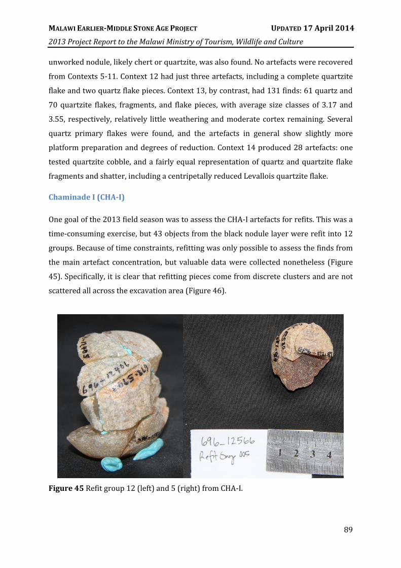
MALAWI EARLIER-MIDDLE STONE AGE PROJECT UPDATED 17 April 2014
2013 Project Report to the Malawi Ministry of Tourism, Wildlife and Culture
89
unworked nodule, likely chert or quartzite, was also found. No artefacts were recovered
from Contexts 5-11. Context 12 had just three artefacts, including a complete quartzite
flake and two quartz flake pieces. Context 13, by contrast, had 131 finds: 61 quartz and
70 quartzite flakes, fragments, and flake pieces, with average size classes of 3.17 and
3.55, respectively, relatively little weathering and moderate cortex remaining. Several
quartz primary flakes were found, and the artefacts in general show slightly more
platform preparation and degrees of reduction. Context 14 produced 28 artefacts: one
tested quartzite cobble, and a fairly equal representation of quartz and quartzite flake
fragments and shatter, including a centripetally reduced Levallois quartzite flake.
Chaminade I (CHA-I)
One goal of the 2013 field season was to assess the CHA-I artefacts for refits. This was a
time-consuming exercise, but 43 objects from the black nodule layer were refit into 12
groups. Because of time constraints, refitting was only possible to assess the finds from
the main artefact concentration, but valuable data were collected nonetheless (Figure
45). Specifically, it is clear that refitting pieces come from discrete clusters and are not
scattered all across the excavation area (Figure 46).
Figure 45 Refit group 12 (left) and 5 (right) from CHA-I.
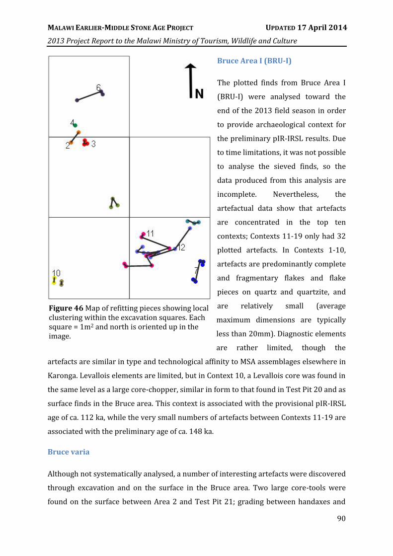
MALAWI EARLIER-MIDDLE STONE AGE PROJECT UPDATED 17 April 2014
2013 Project Report to the Malawi Ministry of Tourism, Wildlife and Culture
90
Bruce Area I (BRU-I)
The plotted finds from Bruce Area I
(BRU-I) were analysed toward the
end of the 2013 field season in order
to provide archaeological context for
the preliminary pIR-IRSL results. Due
to time limitations, it was not possible
to analyse the sieved finds, so the
data produced from this analysis are
incomplete. Nevertheless, the
artefactual data show that artefacts
are concentrated in the top ten
contexts; Contexts 11-19 only had 32
plotted artefacts. In Contexts 1-10,
artefacts are predominantly complete
and fragmentary flakes and flake
pieces on quartz and quartzite, and
are relatively small (average
maximum dimensions are typically
less than 20mm). Diagnostic elements
are rather limited, though the
artefacts are similar in type and technological affinity to MSA assemblages elsewhere in
Karonga. Levallois elements are limited, but in Context 10, a Levallois core was found in
the same level as a large core-chopper, similar in form to that found in Test Pit 20 and as
surface finds in the Bruce area. This context is associated with the provisional pIR-IRSL
age of ca. 112 ka, while the very small numbers of artefacts between Contexts 11-19 are
associated with the preliminary age of ca. 148 ka.
Bruce varia
Although not systematically analysed, a number of interesting artefacts were discovered
through excavation and on the surface in the Bruce area. Two large core-tools were
found on the surface between Area 2 and Test Pit 21; grading between handaxes and
Figure 46 Map of refitting pieces showing local clustering within the excavation squares. Each square = 1m2 and north is oriented up in the image.

MALAWI EARLIER-MIDDLE STONE AGE PROJECT UPDATED 17 April 2014
2013 Project Report to the Malawi Ministry of Tourism, Wildlife and Culture
91
chopper-cores, these large objects are similar to those described for the lower levels of
Clark’s 1965 excavation at Chaminade 1A. It is a bit surprising that this type of artefact
was not encountered during the systematic surface collection in 2012, but that
collection took place further downslope and may relate to a different depositional
sequence. The presence of these artefacts does reinforce the idea of an older component
in the Chitimwe Beds, even if they are currently undated (Figure 47).
A piece of what appears to be flaked bone was found during excavation at Area II, from
Context 17 in Square A1 (Lot 2149). While it is possible that this is a non-anthropogenic
occurrence, the object has morphological characteristics that are identical to those seen
on flaked stone, including a clear platform for percussion, a bulb of percussion, and a
previous removal on what could be considered the dorsal surface. It would be highly
unusual if this was confirmed as bone preserved in the lateritic sediments at Bruce,
although the presence of soil carbonates in the area may have acted as a buffer against
dissolution of artefacts manufactured on fossil bone. This phenomenon has also been
found to occur at Mwanganda’s Village {Thompson, 2009 #5558}.
To make this find even more
remarkable, an additional seven
pieces of flaked(?) bone were
recovered from Context 16,
immediately above, through wet-
sieving, and in excavation in
Square A0, Context 22 (Figure
48). These pieces also show
characteristics that would be
expected of flaked stone, though
none are unequivocally flaked. The
margin of one piece is irregular,
and looks a bit like a cranial
suture, while a different piece
seems to have on its dorsal surface
Figure 47 Surface finds from Bruce that suggest an older depositional sequence at the locality.

MALAWI EARLIER-MIDDLE STONE AGE PROJECT UPDATED 17 April 2014
2013 Project Report to the Malawi Ministry of Tourism, Wildlife and Culture
92
a bit of the exterior bone surface. In the same depositional layer, a series of very large,
extremely fresh quartzite flakes were found; these pieces have not been shown to refit,
but color and quality of the raw material suggest they likely come from the same core.
Sadala South
This 1x3m geological trench
approximately 6km south of Karonga
was not excavated archaeologically, but
several artefacts unearthed during its
emplacement in 2012 were collected so
that their potential significance could be
explored. This site shows the clearest
evidence for an Acheulean occupation of
the Karonga region. Of the 98 artefacts
recovered (6 from the upper unit, 92
from the lower unit), the most
compelling is an unweathered, finely
worked chert handaxe. This was
recovered at below 1.5m depth from the
trench, from which OSL and Cosmogenic
Figure 48 Potential pieces of flaked bone from BRU-II.
Figure 49 Chert handaxe recovered from the Sadala South trench (at rear, ca. 3m deep).

MALAWI EARLIER-MIDDLE STONE AGE PROJECT UPDATED 17 April 2014
2013 Project Report to the Malawi Ministry of Tourism, Wildlife and Culture
93
nuclide dating is currently underway.
At 116mm in length, the Sadala South handaxe is the largest chert artefact recovered in
any subsurface investigation of the Karonga region. Only 43 chert objects have been
found among the 15,000+ artefacts analysed thus far from MEMSAP excavations; with
the exception of four, are all 30mm or less in maximum dimension. A bifacial,
centripetally flaked chert core (max. dimension = 45mm) was found in the same unit at
Sadala South, and similar to the quartzite cores from Test Pit 13, it shows elements of
technological organization consistent with Levallois reduction, while failing to maintain
others. The presence of these two relatively large but extensively flaked chert artefacts
is highly incongruous with the other Karonga assemblages, as well as the known locally
available raw material.
Recent surface survey approximately 60km south of Karonga has revealed a slightly
higher incidence of chert artefacts and a few unworked chert nodules; this increase in
size and number of chert suggests a primary source to the south of Karonga. At Sadala
South Quartz is slightly more common in the lower unit (57.1%), and the vein quartz-
like quartzite found at Test Pit 13 represents 11.9% of the total quartzite at Sadala
South. No Levallois artefacts were recovered from the lower unit, though one Levallois
core on a flake was found in the upper sandy unit of the trench. This piece is strongly
reminiscent of the cores-on-flakes noted at Test Pit 20, though this and the example
from Bruce show a novel approach at Karonga to the production of a Levallois core. The
flake’s ventral surface served as the upper ‘Levallois’ hemisphere, providing natural
lateral and distal convexities without extensive ‘preparing flakes,’ while the flake’s
cortical dorsal surface provided the volume typically associated with lower
hemispheres of Levallois cores (Boëda 1995). Artefacts show little evidence for post-
depositional movement or weathering, and it is likely that Sadala South is a stratified, in
situ occurrence of Acheulean and overlying MSA deposits. Expanded and controlled
excavation at Sadala South will provide an essential data set for addressing the
Acheulean in Central Africa by exploring the innovating behaviors of our species’
immediate forbearers.

MALAWI EARLIER-MIDDLE STONE AGE PROJECT UPDATED 17 April 2014
2013 Project Report to the Malawi Ministry of Tourism, Wildlife and Culture
94
MGD-I
The prinicpal objective of excavation as this site was to understand the archaeological
deposits that overlay those designated by Clark “elephant buthery site“. After discovery
in 2011 of an intact series of deposits with refitting artefacts, a secondary objective
became to recover and refit other artefacts from the area – with an aim toward
understanding the distribution of activity areas and possibly identifying the site
boundaries. This study shows a clear concentration in the centre of the excavation area
(Figure 50). After refitting was completed, techno-typological analysis of the artefacts
was also completed in 2013.

MALAWI EARLIER-MIDDLE STONE AGE PROJECT UPDATED 17 April 2014
2013 Project Report to the Malawi Ministry of Tourism, Wildlife and Culture
95
Figure 50 3D (a, b, c) and 2D plan view maps of the distribution of plotted finds (small black dots) relative to plotted finds that are part of a conjoining unit (coloured circles). The 3D view (southeast) allows visualisation of the sedimentary units as volumes.
A total of 3332 stone finds were recovered from excavations at MGD-I, of which were
3034 were identified as flaked or battered stone artefacts. The vast majority of these are
flakes (n=2196), followed by angular fragments (n=655), cores (n=124) and retouched
flakes (n=53). The assemblage includes a minimum of 62 identified conjoin sets and 38
raw material units, attesting to exploitation of gravels available locally to the site. While
conjoin sets occur in all layers, they tend to be concentrated in the middle stratigraphic

MALAWI EARLIER-MIDDLE STONE AGE PROJECT UPDATED 17 April 2014
2013 Project Report to the Malawi Ministry of Tourism, Wildlife and Culture
96
layers of the deposit (Figure 50), most notably in the brown clayey sands (BCS).
Artefacts from MGD-I also show relatively low rates of edge rounding, with 87.2%
showing no signs of post-depositional reworking.
The artefacts throughout the MGD-I deposit, but particularly in the denser stratigraphic
layers, are characteristically MSA. Radial or discoidal reduction methods occur
throughout, but are generally concentrated in and below layer BCS. Also present in BCS
is a reasonably distinct reduction system featuring the unifacial radial working of small
quartz crystal pebbles. The notable aspect of this kind of reduction is both the small size
of the flakes produced, and the general absence of bipolar working. No typologically-
regular implement types were observed. With ages placing this system ~22 ka, it may
be considered a regionally distinct late MSA expression of great significance in
understanding the transition of the MSA to the LSA across central Africa.
MGD-II
A total of 438 finds have been examined from MGD-II, of which 278 were determined to
be artefactual. Again, these are mostly flakes (n=221), with reasonable representation of
angular fragments (n=43) and small numbers of cores (n=8) and retouched flakes
(n=6). Unlike MGD-I, MGD-II shows heavy signs of fluvial reworking. Only 42.8% of
artefacts have no edge abrasion, while 14.5% have been abraded sufficiently that they
can only just be discerned as having been artefacts.
As with MGD-I, MGD-II contains typically MSA artefacts including discoidal cores
throughout, but also present are some potentially later markers including a Levallois
point. Further work is required to differentiate the stratigraphic levels of the site and to
test whether, within the general theme of reworking, intact or largely intact units can be
identified. However, initial analysis suggests that these artefacts are part of a lag deposit
overlying a recent channel that cut through the site ca. 15 ka {Wright, 2014 #6402}.
MGD-III
The recovered assemblage from MGD-III numbers 672 pieces, of which 573 were
determined to be artefactual. Flakes account for 463 artefacts, followed in abundance by

MALAWI EARLIER-MIDDLE STONE AGE PROJECT UPDATED 17 April 2014
2013 Project Report to the Malawi Ministry of Tourism, Wildlife and Culture
97
angular fragments (n=76), cores (n=16) and retouched flakes (n=8). Overall, much of
the assemblage appears to relate to the earlier Middle Stone Age, with large alternately-
worked cores and discoidal cores present, along with many flakes with dihedral and
faceted platforms. Also present, however, are two scrapers, a unifacial point, a backed
artefact and some pieces of pottery. This, combined with the very low prevalence of
unabraded artefacts (24.3%) suggests that the assemblage is extensively mixed and that
very old and very recent artefacts may be present in similar levels. As with MGD-II,
further work is required to assess the integrity of different stratigraphic layers, and to
determined whether there may in fact be some partially or substantially intact layers in
this part of the site. Preliminary analysis suggests that the majority of the artefacts
derive from the same upper lag deposit that marks MGD-II – the “stony soil“ of Kaufulu
{Kaufulu, 1990 #5357}. Future work will focus on separating the characteristics of these
from those of the artefacts recovered from the same palaeosol unit that yielded the
elephant skeleton {Wright, 2014 #6402}.
Chaminadae III (CHA-III)
The analysis of CHA-III has so far been very limited, but does provide initial insight into
the archaeological occupation of the site. The following points can be made:
The site appears to include components from the Middle and Later Stone Ages
o The latter includes backed artefacts
Changes in material selection are gradual through the sequence.
Flake platform size gradual increases with depth through the sequence
The quartz rocks include pieces sourced from outcrops, differentiating the
material acquistion pattern here from that at MGD
While assessments of the continuity of deposit accumulation at CHA-III remain to be
developed, the sequence as it stands may plausible include a Middle to Later Stone Age
transition, and also appears to contain one of the only significant, intact backed artefact-
bearing assemblages so far recovered by MEMSAP – with the possible except of the
deeply buried LSA assemblage from Test Pit 8.

MALAWI EARLIER-MIDDLE STONE AGE PROJECT UPDATED 17 April 2014
2013 Project Report to the Malawi Ministry of Tourism, Wildlife and Culture
98
Figure 51 Raw material change in the plotted finds from square C4 of CHA-III by context.
The age of the CHA-III assemblage will be of considerable interest, as will analysis of the
nature of the potential transition at the site. This is particularly true considering the
preliminary age estimates that potentially constrain the artefact deposition to between
ca. 37 ka and ca. 57 ka – a relatively brief period of occupation, especially when
considering that this period also encompasses ca. 3m of artefactually sterile sediment at
the base. At the moment, with the limited amount of work carried out, CHA-III can be
suggested as a site of considerable regional significance and one of the few open-air
sites in Africa that potentially captures the MSA-LSA transition in situ. It is also notable
that preliminary age estimates for three sites in the Karonga region (MGD-I, CHA-I, and
CHA-III) have deposits with occupation dating to the period between ca. 44 - 37 ka.
VIII. SUMMARY

MALAWI EARLIER-MIDDLE STONE AGE PROJECT UPDATED 17 April 2014
2013 Project Report to the Malawi Ministry of Tourism, Wildlife and Culture
99
Summary and Conclusions
The 2013 field season undertook a range of activities designed to finalise investigation
of key sites near the town of Karonga and prepare them for publication, whilst also
paving the way for the next phase of MEMSAP research. All excavations proceeded on
schedule and met the stated goals for sampling and artefact recovery. The effects of
slope wash and bioturbation were characterised at the sites of CHA-III and CHA-IV,
which will enable stronger interpretation of the OSL ages sampled from the profiles. At
Bruce, site formation was further explored and the very small remnant of intact MSA
deposit was identified near the BRU-II excavation.
The survey revealed more detailed patterns in MSA stone artefact reduction and raw
material abundances. It also confirmed that although MSA materials are common in
catchments north of the North Rukuru, they are not in situ. This is most likely because
higher precipitation in the northern catchments has eroded previous Middle to Late
Pleistocene alluvial fan deposits away and many MSA materials were deposited directly
upon colluvium, pediments, or other non-aggradational surfaces.
In accordance with the timeline for research, several analytical tasks were also
completed. These include stone artefacts, geoarchaeology, OSL, ochre analysis, and
spatial analysis. Their completion allowed for submission of several manuscripts, four
of which have been published or accepted within the 12 months since the last report.
Preliminary OSL analysis reported here suggests that near the town of Karonga, alluvial
fan deposition began prior to ca. 100 ka. However, MSA occupation does not appear in
situ until ca. 63 ka, at the site of TP7. The adjacent site of CHA-III shows a rapid
deposition of alluvial deposits, interspersed with MSA artefacts that transition into the
LSA by ca. 37 ka. This is in contrast to other LSA materials recovered from MGD-I, in
which LSA materials that retain an MSA character persist until ca. 22 ka. Across all sites
for which we have ages to date, there is a clear clustering of MSA occupation in the
region between ca. 45 – 35 ka. As this picture continues to unfold, we will be able to
describe in detail how MSA behaviour relates to local periods of climatic change.
Future work will now focus on bringing together the last five years of fieldwork into a
meaningful picture of the past, with more publications to follow. The majority of work

MALAWI EARLIER-MIDDLE STONE AGE PROJECT UPDATED 17 April 2014
2013 Project Report to the Malawi Ministry of Tourism, Wildlife and Culture
100
for this project phase near Karonga town is now complete. Future field seasons will
include two components. One will be to investigate deposits outside the immediate
proximity of Karonga town that are likely to contain older archaeological materials.
These will begin with the site of Sadala South, where a handaxe was recovered in 2012
and where a cosmogenic nuclide depth profile is currently being produced that will aid
in age control. The other will be continued survey and test-pitting at landscape and
catchment scales, in order to better understand how MSA people moved about the
region and what strategies they employed to mitigate the effects of severe climate
change as recorded in the Lake Malawi sediment cores.
Acknowledgements
The authors firstly thank the Malawi Government for their continued support for the
project. Permits were provided by Director of Culture Dr. Elizabeth Gomani-Chindebvu
and Deputy Director of Culture/Director of Antiquities Ms. Chrissy Chiuma. In 2013 the
crew comprised a mix of specialist scientists, professional staff, students, and an
outstanding crew of local workers. Mr. Oris Malijani, Mr. Malani Chinula, Mr. Frederick
Mapemba, and Mr. Joseph Tembo represented Malawi Antiquities in the field, with an
inspection visit made by Ms. Chiumia. Mr. James Flittner kindly gave of his own time and
resources to participate in the surveys, and was accompanied by Mr. Davie Simengwa.
We appreciate the continued support of the local community, and are very grateful to
Prof. Friedemann Schrenk for assisting us with the storage of our field equipment. This
season’s work was supported by the National Geographic-Waitt Foundation (grant to
Thompson), the National Research Foundation of Korea (grant to Wright and Choi), the
Australian Institute for Nuclear Science and Engineering (grant to Thompson, Heimsath,
and Arrowsmith), the University of Tübingen (funds to Miller), and Australian Research
Council Discovery grant DP110101305 (to Thompson, Arrowsmith, and Cohen). The
University of Queensland has provided access to the technical equipment used over the
life of the project so far.

MALAWI EARLIER-MIDDLE STONE AGE PROJECT UPDATED 17 April 2014
2013 Project Report to the Malawi Ministry of Tourism, Wildlife and Culture
101
IX. REFERENCES CITED
Andrefsky, W. A. J. (1994) Raw material availability and the organisation of technology. American Antiquity, 59, 21-34.
Andrefsky, W. J. 2005. Lithics: Macroscopic Approaches to Analysis. Cambridge: Cambridge University Press.
Bamforth, D. B. (1986) Technological efficiency and tool curation. American Antiquity, 51, 38-50. Barham, L. (1998) Possible early pigment use in south-central Africa. Current Anthropology, 39,
703-710. Barham, L. S. 2000. The Middle Stone Age of Zambia, south-central Africa. Bristol: Western
Academic and Specialist Press. Barham, L. S. (2002) Systematic pigment use in the Middle Pleistocene of South-Central Africa.
Current Anthropology, 43, 181-190. Barut, S. (1994) Middle and Later Stone Age lithic technology and land use in East African
savannas. African Archaeological Review, 12, 43-72. Basell, L. S. (2008) Middle Stone Age (MSA) site distributions in eastern Africa and their
relationship to Quaternary environmental change, refugia and the evolution of Homo sapiens. Quaternary Science Reviews, 27, 2484-2498.
Biggs, J., E. Nissen, T. Craig, J. Jackson & D. P. Robinson (2010) Breaking up the hanging wall of a rift-border fault: The 2009 Karonga earthquakes, Malawi. Geophys. Res. Lett., 37, L11305.
Blome, M. W., A. S. Cohen, C. A. Tryon, A. S. Brooks & J. Russell (2012) The environmental context for the origins of modern human diversity: A synthesis of regional variability in African climate 150,000–30,000 years ago. Journal of Human Evolution, 62, 563-592.
Boëda, E. 1995. Levallois: A volumetric construction, methods, and technique. In The definition and Interpretation of Levallois Technology eds. H. L. Dibble & O. Bar-Yosef, 41-68. Madison, Wisconsin: Prehistory Press.
Bousman, C. B. (1993) Hunter-gatherer adaptations, economic risk and tool design. Lithic Technology, 18, 59-86.
Bousman, C. B. & K. Cruz-Uribe. 1998. Strategies for coping with risk: Later Stone Age hunter- gatherers at Blydefontein rock shelter.
Braun, D. R., T. Plummer, P. Ditchfield, J. V. Ferraro, D. Maina, L. C. Bishop & R. Potts (2008) Oldowan behavior and raw material transport: perspectives from the Kanjera Formation. Journal of Archaeological Science, 35, 2329-2345.
Braun, D. R., T. Plummer, J. V. Ferraro, P. Ditchfield & L. C. Bishop (2009) Raw material quality and Oldowan hominin toolstone preferences: evidence from Kanjera South, Kenya. . Journal of Archaeological Science, 36, 1605-1614.
Brown, E. T., T. C. Johnson, C. A. Scholz, A. S. Cohen & J. W. King (2007) Abrupt change in tropical African climate linked to the bipolar seesaw over the past 55,000 years. Geophys. Res. Lett., 34.
Chase, P. G. & H. L. Dibble (1990) On the emergence of modern humans. Current Anthropology, 38, 58-59.
Clark, J. D. (1966) Archaeology in Malawi. Society of Malawi Journal, 19, 15-25. Clark, J. D. 1968. Antiquities programme: Malawi - (mission) 19 July-15 September 1968. In
UNESCO Document, 73. Paris. Clark, J. D. 1972. Archaeological mission: Malawi - (mission) July-September 1972. In UNESCO
Document, 17. Paris. Clark, J. D., C. V. Haynes, J. E. Mawby & A. Gautier. 1967. Interim report on palaeo-
anthropological investigations in the Lake Malawi Rift. Clark, J. D., C. V. Haynes, J. E. Mawby & A. Gautier (1970) Interim report on
palaeoanthropological investigations in the Lake Malawi Rift. Quaternaria, 13, 305-354.

MALAWI EARLIER-MIDDLE STONE AGE PROJECT UPDATED 17 April 2014
2013 Project Report to the Malawi Ministry of Tourism, Wildlife and Culture
102
Clark, J. D. & C. V. J. Haynes (1970) An elephant butchery site at Mwanganda's Village, Karonga, Malawi, and its relevance for Palaeolithic archaeology. World Archaeology, 1, 390-411.
Clark, J. D., E. A. Stephens & S. C. Coryndon (1966) Pleistocene fossiliferous lake beds of the Malawi (Nyasa) Rift: a preliminary report. American Anthropologist, 68, 46-87.
Cohen, A., J. R. Stone, K. R. M. Beuning, L. E. Park, P. N. Rainthal, D. Dettman, C. A. Scholz, T. C. Johnson, J. W. King, M. R. Talbot, E. T. Brown & S. J. Ivory (2007) Ecological consequences of early Late Pleistocene megadroughts in tropical Africa. Proceedings of the National Academy of Science, 104, 16422-16427.
Collard, M., M. Kemery & S. Banks (2005) Causes of toolkit variation among hunter-gatherers: a test of four competing hypotheses. Canadian Journal of Archaeology, 29, 1-19.
Courty, M. A., P. Goldberg & R. Macphail. 1989. Soils and Micromorphology in Archaeology. Cambridge: Cambridge University Press.
Crossley, R. (1986) Sedimentation by termites in the Malawi Rift Valley. Geological Society, London, Special Publications, 25, 191-199.
d'Errico, F. & C. B. Stringer (2011) Evolution, revolution or saltation scenario for the emergence of modern cultures? Philosophical Transactions of the Royal Society B: Biological Sciences, 366, 1060-1069.
Deino, A. L. & S. McBrearty (2002) 40 Ar/ 39 Ar dating of the Kapthurin Formation, Baringo, Kenya. Journal of Human Evolution, 42, 185-210.
Dibble, H. L. & Z. Rezek (2009) Introducing a new experimental design for controlled studies of flake formation: results for exterior platform angle, platform depth, angle of blow, velocity, and force. Journal of Archaeological Science, 36, 1945-1954.
Dibble, H. L., U. A. Schurmans, R. P. Iovita & M. V. McLaughlin (2005) The measurement and interpretation of cortex in lithic assemblages. American Antiquity, 545-560.
Dietl, H., A. W. Kandel & N. Conard (2005) Middle Stone Age settlement and land use at the open-air sites of Geelbek and Anyskop, South Africa. Journal of African Archaeology, 3, 233-244.
Douglass, M. J., S. J. Holdaway, P. C. Fanning & J. I. Shiner (2008) An assessment and archaeological application of cortex measurement in lithic assemblages. American Antiquity, 513-526.
Dunnell, R. 1992. The notion site. In Space, Time and Archaeological Landscapes. , eds. J. Rossignol & L. Wandsnider, 21-41. New York: Plenum Press.
Ebinger, C. J., J. A. Jackson, A. N. Foster & N. J. Hayward (1999) Extensional basin geometry and the elastic lithosphere. Philosophical Transactions of the Royal Society of London Series a-Mathematical Physical and Engineering Sciences, 357, 741-762.
Ebinger, C. J., B. R. Rosendahl & D. J. Reynolds (1987) Tectonic Model of the Malawi Rift, Africa. Tectonophysics, 141, 215-235.
Einsele, G. (1996) Event deposits: The role of sediment supply and relative sea-level changes - Overview. Sedimentary Geology, 104, 11-37.
Fagereng, Å. (2013) Fault segmentation, deep rift earthquakes and crustal rheology: Insights from the 2009 Karonga sequence and seismicity in the Rukwa-Malawi rift zone. Tectonophysics.
Fanning, P., S. Holdaway, E. J. Rhodes & T. Bryant (2009) The surface archaeological record in arid Australia: Geomorphic controls on preservation, exposure, and visibility. Geoarchaelogy, 24, 121-146.
Fanning, P. C., S. J. Holdaway & E. J. Rhodes (2008) A new geoarchaeology of Aboriginal artefact deposits in western NSW, Australia: establishing spatial and temporal geomorphic controls on the surface archaeological record. Geomorphology, 101, 524-532.
Gamble, C. 1994. Timewalkers: The Prehistory of Global Colonization. Cambridge: Harvard University Press.
Goldberg, P. & R. I. Macphail (2003) Short Contribution: Strategies and Techniques in Collecting Micromorphology Samples. Geoarchaeology, 18, 571-578.

MALAWI EARLIER-MIDDLE STONE AGE PROJECT UPDATED 17 April 2014
2013 Project Report to the Malawi Ministry of Tourism, Wildlife and Culture
103
Gould, R. (1991) Arid-land foraging as seen from Australia: adaptive models and behavioral realities. Oceania, 62, 12-33.
Green, R. L. & R. J. Watling (2007) Trace element fingerprinting of Australian ocher using Laser Ablation Inductively Coupled Plasma-Mass Spectrometry (LAICP-MS) for the provenance establishment and authentication of indigenous art. Journal of Forensic Science, 52, 851-859.
Harben, P. W. & M. Kužvart. 1996. Industrial Minerals: A Global Geology. London: Industrial Minerals Information Ltd.
Henshilwood, C. S., F. d'Errico & I. Watts (2009) Engraved ochres from the Middle Stone Age levels at Blombos Cave, South Africa. Journal of Human Evolution, 57, 27-47.
Henshilwood, C. S., F. D'Errico, R. Yates, Z. Jacobs, C. Tribolo, G. A. T. Duller, N. Mercier, J. C. Sealy, H. Valladas, I. Watts & A. G. Wintle (2002) Emergence of modern human behavior: Middle Stone Age engravings from South Africa. Science, 295, 1278-1280.
Henshilwood, C. S., F. d’Errico, K. L. van Niekerk, Y. Coquinot, Z. Jacobs, S.-E. Lauritzen, M. Menu & R. García-Moreno (2011) A 100,000-year-old ochre-processing workshop at Blombos Cave, South Africa. Science, 334, 219-222.
Henshilwood, C. S. & C. W. Marean (2003) The origin of modern human behavior: Critique of the models and their test implications. Current Anthropology, 44, 627-651.
Hijmans, R. J., S. E. Cameron, J. L. Parra, P. G. Jones & A. Jarvis (2005) Very high resolution interpolated climate surfaces for global land areas. International Journal of Climatology, 25, 1965-1978.
Hiscock, P. (1994) Technological responses to risk in Holocene Australia. Journal of World Prehistory, 8, 267-292.
Holdaway, S. & P. Fanning (2008) Developing a Landscape History as Part of a Survey Strategy: A Critique of Current Settlement System Approaches based on Case Studies from Western New South Wales, Australia. Journal of Archaeological Method and Theory 15, 167-189.
Inizan, M.-L., M. Reduron-Ballinger, H. Roche & J. Tixier. 1999. Technology and Terminology of Knapped Stone. Nanterre: CREP.
Johnson, K., E. Nissen, S. Saripalli, J. R. Arrowsmith, P. McGarey, K. Scharer, P. Williams & K. Kimberly Blisniuk (In review) Rapid mapping of ultra-fine fault zone topography with Structure from Motion. Geosphere.
Johnson, T. C., E. T. Brown, J. McManus, S. Barry, P. Barker & F. Gasse (2002) A high-resolution paleoclimate record spanning the past 25,000 years in southern East Africa. Science, 296, 113-+.
Juwayeyi, Y. & C. G. Betzler (1995) Archaeology of the Malawi Rift: the search continues for Early Stone Age occurences in the Chiwondo Beds, northern Malawi. Journal of Human Evolution, 28, 115-116.
Kaufulu, Z. (1990) Sedimentary environments at the Mwanganda site, Malawi. Geoarchaeology, 5, 15-27.
Kaufulu, Z., E. S. Vrba & T. D. White (1981) Age of the Chiwondo Beds, Northern Malawi. Annals of the Transvaal Museum, 33, 1-8.
Kaufulu, Z. M. 1983. The geological context of some early archaeological sites in Kenya, Malawi and Tanzania: Microstratigraphy, site formation and interpretation. In Department of Anthropology, 340. Berkeley: University of California, Berkeley.
Klein, R. G. (2008) Out of Africa and the evolution of human behavior. Evolutionary Anthropology, 17, 267-281.
Kuhn, S. L. (1991) “Unpacking” reduction: lithic raw material economy in the Mousterian of West-Central Italy. Journal of Anthropological Archaeology, 10, 76-106.
Lin, S. C., Z. Rezek, D. Braun & H. L. Dibble (2013) On the Utility and Economization of Unretouched Flakes: The Effects of Exterior Platform Angle and Platform Depth. American Antiquity, 78, 724-745.

MALAWI EARLIER-MIDDLE STONE AGE PROJECT UPDATED 17 April 2014
2013 Project Report to the Malawi Ministry of Tourism, Wildlife and Culture
104
Loarie, S. R., P. B. Duffy, H. Hamilton, G. P. Asner, C. B. Field & D. D. Ackerly (2009) The velocity of climate change. Nature, 462, 1052-1055.
Mackay, A. (2008) A method for estimating edge length from flake dimensions: use and implications for technological change in the southern African MSA. Journal of Archaeological Science, 35, 614-622.
Marean, C. W. (2010) Introduction to the Special Issue - The Middle Stone Age at Pinnacle Point Site 13B, a coastal cave near Mossel Bay (Western Cape Province, South Africa). Journal of Human Evolution, 59, 231-233.
Marean, C. W., M. Bar-Matthews, J. Bernatchez, E. Fisher, P. Goldberg, A. I. R. Herries, Z. Jacobs, A. Jerardino, P. Karkanas, T. Minichillo, P. J. Nilssen, E. Thompson, I. Watts & H. M. Williams (2007) Early human use of marine resources and pigment in South Africa during the Middle Pleistocene. Nature, 449, 905-908.
McBrearty, S. & A. S. Brooks (2000) The revolution that wasn't: A new interpretation of the origin of modern human behavior. Journal of Human Evolution, 39, 453-563.
McCall, G. (2007) Behavioral ecological models of lithic technological change during the later Middle Stone Age of South Africa. Journal of Archaeological Science, 34, 1738-1751.
McDougall, I., F. H. Brown & J. Fleagle (2005) Stratigraphic placement and age of modern humans from Kibish, Ethiopia. Nature, 433, 733-736.
McPherron, S. J. P. (2005) Artifact orientations and site formation processes from total station proveniences. Journal of Archaeological Science, 32, 1003-1014.
McPherron, S. P., H. Dibble & P. Goldberg (2005) Z. Geoarchaeology, 20, 243-262. Mellars, P. 2007. Rethinking the human revolution: Eurasian and African perspectives. In
Rethinking the Human Revolution eds. P. Mellars, K. Boyle, O. Bar-Yosef & C. Stringer, 1-14. Cambridge: McDonald Institute for Archaeological Research.
Mentzer, S. & J. Quade (2013) Compositional and isotopic analytical methods in archaeological micromorphology. . Geoarchaeology 28, 87-97.
Mercader, J., Y. Asmeromb, T. Bennett, M. Raja & A. Skinner (2009) Initial excavation and dating of Ngalue Cave: A Middle Stone Age site along the Niassa Rift, Mozambique. Journal of Human Evolution, 57, 63–74.
Porat, N., M. Chazan, R. Grün, M. Aubert, V. Eisenmann & L. K. Horwitz (2010) New radiometric ages for the Fauresmith industry from Kathu Pan, southern Africa: Implications for the Earlier to Middle Stone Age transition. Journal of Archaeological Science, 37, 269-283.
Read, D. (2008) An interaction model for resource implement complexity based on risk and number of annual moves. American Antiquity, 73, 599-625.
Rezek, Z., S. Lin, R. Iovita & H. L. Dibble (2011) The relative effects of core surface morphology on flake shape and other attributes. Journal of Archaeological Science, 38, 1346-1359.
Ring, U. (1994) The Influence of Preexisting Structure on the Evolution of the Cenozoic Malawi Rift (East-African Rift System). Tectonics, 13, 313-326.
Rosendahl, B. R. (1987) Architecture of Continental Rifts with Special Reference to East-Africa. Annual Review of Earth and Planetary Sciences, 15, 445-503.
Scholz, C. A., A. S. Cohen, T. C. Johnson, J. King, M. R. Talbot & E. T. Brown (2011) Scientific drilling in the Great Rift Valley: The 2005 Lake Malawi Scientific Drilling Project — An overview of the past 145,000 years of climate variability in Southern Hemisphere East Africa. Palaeogeography, Palaeoclimatology, Palaeoecology, 303, 3-19.
Scholz, C. A., T. C. Johnson, A. S. Cohen, J. W. King, J. A. Peck, J. T. Overpeck, M. R. Talbot, E. T. Brown, L. Kalindekafe, P. Y. O. Amoako, R. P. Lyons, T. M. Shanahan, I. S. Castaneda, C. W. Heil, S. L. Forman, L. R. McHargue, K. R. Beuning, J. Gomez & J. Pierson (2007) East African megadroughts between 135 and 75 thousand years ago and bearing on early-modern human origins. Proceedings of the National Academy of Science, 104, 16416-16421.
Stamps, D. S., E. Calais, E. Saria, C. Hartnady, J. M. Nocquet, C. J. Ebinger & R. M. Fernandes (2008) A kinematic model for the east African rift. Geophysical Research Letters, 35.

MALAWI EARLIER-MIDDLE STONE AGE PROJECT UPDATED 17 April 2014
2013 Project Report to the Malawi Ministry of Tourism, Wildlife and Culture
105
Stephens, E. A. (1966) Geological account of the northwest coast of Lake Malawi between Karonga and Lion Point, Malawi. American Anthropologist, 68, 50-58.
Stone, J. R., K. S. Westover & A. S. Cohen (2011) Late Pleistocene paleohydrography and diatom paleoecology of the central basin of Lake Malawi, Africa. Palaeogeography, Palaeoclimatology, Palaeoecology, 303, 51-70.
Stoops, G. 2003. Guidelines for analysis and description of soil and regolith thin sections. . Madison, Wisconsin, USA: Soil Science Society of America, Inc.
Strahler, A. H. & A. N. Strahler. 1992. Modern Physical Geography. New York: Wiley. Thompson, J. C. 2010. The Malawi Earlier-Middle Stone Age Project: Preliminary Results from
2009 Fieldwork. In Paleoanthropology Society. St. Louis, Missouri. Thompson, J. C., V. De Moor, F. Schilt, S. Mentzer, M. Bravo Foster, S. Robinson, S. Nightingale, A.
Mackay, A. Zipkin, D. K. Wright, M. Welling & E. Gomani-Chindebvu. 2013a. Malawi Earlier-Middle Stone Age Project – 2012 Preliminary Project Report. 141. Lilongwe: Malawi Department of Antiquities.
Thompson, J. C., A. Mackay, V. de Moor & E. Gomani-Chindebvu (2014, in press) Catchment survey in the Karonga District: A landscape-scale analysis of core reduction strategies and provisioning during the Middle Stone Age of northern Malawi. African Archaeological Review.
Thompson, J. C., A. Mackay & M. Welling. 2011. Malawi Earlier-Middle Stone Age Project – 2010 Project Report. 146. Lilongwe: Malawi Department of Antiquities.
Thompson, J. C., A. Mackay, D. K. Wright, M. Welling, A. Greaves, E. Gomani-Chindebvu & D. Simenga (2012a) Renewed Investigations into the Middle Stone Age of northern Malawi. Quaternary International, 270, 129-139.
Thompson, J. C., M. Welling & E. Gomani-Chindebvu. 2012b. Malawi Earlier-Middle Stone Age Project – 2011 Preliminary Project Report. 146. Lilongwe: Malawi Department of Antiquities.
Thompson, J. C., M. Welling & E. Gomani-Chindebvu (2013b) Using GIS to integrate old and new archaeological data from Stone Age deposits in Karonga, Malawi. International Journal of Heritage in the Digital Era, 2, 611-630.
Thompson, J. C., M. Welling & J. Pargeter. 2009. Field Report from August 2009 Feasibility Study on the Middle Stone Age of Northern Malawi. 62. Malawi Ministry of Tourism, Wildlife, and Culture.
Torrence, R. 1989. Retooling: towards a behavioral theory of stone tools. In Time, Energy, and Stone Tools, 57-66. Cambridge: Cambridge University Press.
Torrence, R. & G. Bailey. 1983. Time budgeting and hunter-gather technology. In Hunter-gatherer Economy in Prehistory: A European Perspective, 11-22. Cambridge: Cambridge University Press.
Tostevin, G. B. (2011) Levels of theory and social practice in the reduction sequence and chaîne opératoire methods of lithic analysis. PaleoAnthropology, 351-375.
Tryon, C., S. McBrearty & P.-J. Texier (2005) Levallois lithic technology from the Kapthurin Formation, Kenya: Acheulian origin and Middle Stone Age diversity. African Archaeological Review, 22, 199-229.
Tryon, C. A. & S. McBrearty (2002) Tephrostratigraphy and the Acheulian to Middle Stone Age transition in the Kapthurin Formation, Kenya. Journal of Human Evolution, 42, 211-236.
Tryon, C. A. & S. McBrearty (2006) Tephrostratigraphy of the Bedded Tuff Member (Kapthurin Formation, Kenya) and the nature of archaeological change in the later middle Pleistocene. Quaternary Research, 65, 492-507.
Tryon, C. A. & R. Potts (2011) Approaches for understanding flake production in the African Acheulean. PaleoAnthropology, 376-389.
Tryon, C. A., N. T. Roach & A. V. Logan (2008) The Middle Stone Age of the northern Kenyan Rift: age and context of new archaeological sites from the Kapedo Tuffs. Journal of Human Evolution, 55, 652–664.

MALAWI EARLIER-MIDDLE STONE AGE PROJECT UPDATED 17 April 2014
2013 Project Report to the Malawi Ministry of Tourism, Wildlife and Culture
106
Veth, P. 2008. Cycles of aridity and human mobility: Risk minimization among Late Pleistocene foragers of the Western Desert, Australia. In Desert Peoples, 100-115. Blackwell Publishing Ltd.
Watts, I. (2002) Ochre in the Middle Stone Age of southern Africa: Ritualized display or hide preservative? South African Archaeological Bulletin, 57, 1-14.
Watts, I. (2010) The pigments from Pinnacle Point Cave 13B, Western Cape, South Africa. Journal of Human Evolution, 59, 392-411.
Wheeler, W. H. & B. R. Rosendahl (1994) Geometry of the Livingstone Mountains Border Fault, Nyasa (Malawi) Rift, East-Africa. Tectonics, 13, 303-312.
Wilkins, J., B. J. Schoville, K. S. Brown & M. Chazan (2012) Evidence for early hafted hunting technology. Science, 338, 942-946.
Wright, D. K., J. C. Thompson, A. Mackay, M. Welling, S. Forman, G. Price, J.-x. Zhao, A. Cohen, O. Malijani & E. Gomani-Chindebvu (2014) Renewed geoarchaeological investigations of Mwanganda’s Village (Elephant Butchery Site), Karonga, Malawi. Geoarchaeology, 29, 98-120.
Zipkin, A., J. Hanchar, A. S. Brooks, M. W. Grabowski, J. C. Thompson & E. Gomani-Chindebvu (2014, in press) Ochre fingerprints: Distinguishing among Malawian mineral pigment sources with homogenized ochre chip LA-ICPMS. Archaeometry.

MALAWI EARLIER-MIDDLE STONE AGE PROJECT UPDATED 17 April 2014
2013 Project Report to the Malawi Ministry of Tourism, Wildlife and Culture
107
X. APPENDICES
Appendix 1: Detailed sediment profile descriptions from sites investigated in 2013
Sedimentological descriptions of test pits excavated in the Karonga region were
performed by David Wright and Flora Schilt between 25 July and 2 August 2013.
All sedimentary units were tested with 9:1 H2O/HCl. Reactions to acid tests are reported
below only if the sediments demonstrated a reaction. Additionally, all sedimentary
facies were generally “poorly sorted” or “very poorly sorted” and so this descriptor is
not included below.
Chaminade-III and –IV
Chaminade site sits on the shoulder of a steeply sloping ridge associated with alluvial
fan deposition. The site is currently occupied by a single-family home, and agricultural
fields extend across the site.
CHA-III: East wall profile
Unit 1: 0 – 8 cm. Fine to medium subrounded, spheroid pebbles (~25-30%) within a
subangular to subrounded medium and very coarse sand (bimodal); unit is not found
uniformly across the test pit; 2.5YR6/8; soft, friable, non-sticky, non-plastic; no bedding
structures noted.
Unit 2: 8 – 100 cm. Poorly sorted subangular to subrounded medium to coarse sand;
massive; 2.5YR6/8 (bottom), 10R5/8 (top); common Stage 0.5 redox (concentrations)
appear as krotovinas; higher clay context toward the top of the unit on sediments; soft,
friable, non-sticky, non-plastic; no acid effervescence; abrupt, smooth boundary.
Unit 3: 100 – 210 cm. Poorly sorted subangular to subrounded coarse to very coarse
sand and very fine gravel; 2.5R5/8; inclusions of poorly sorted subangular to
subrounded fine gravel (~40%) within poorly sorted angular to subangular coarse

MALAWI EARLIER-MIDDLE STONE AGE PROJECT UPDATED 17 April 2014
2013 Project Report to the Malawi Ministry of Tourism, Wildlife and Culture
108
sandy matrix (10R5/8); soft, friable, non-sticky, non-plastic; common insect, root,
rootlets; abrupt, smooth boundary.
Unit 4: 210 – 215 cm. Poorly sorted, rounded to subrounded coarse gravels (~30%) and
semi-discoidal to spheroidal, 8-12 cm diameter cobbles (2-5%) within a matrix of
poorly sorted subangular to subrounded vert coarse sand and very fine gravel;
2.5YR5/8; hard, friable, non-sticky, non-plastic; few rootlets; no effervescence; abrupt,
slightly wavy boundary.
Unit 5: 215 – 240 cm. Poorly sorted subangular to subrounded coarse to very coarse
sand with 15-25% fine to medium subrounded gravel; 2.5YR5/8; common weathering
feldspar; clear clay films on the gravels; common redoximorphic mottles; soft, friable,
non-sticky, non-plastic; common roots, rootlets, and insect disturbances; abrupt, slightly
wavy boundary.
Unit 6: 240 – 245 cm. Poorly sorted subangular to subrounded, semi-discoidal to semi-
spheroidal medium to coarse gravel (25-50%) in a matrix of poorly sorted subangular
to subrounded, semi-discoidal to spherical coarse to very coarse sand and very fine
gravel; common, dispersed, weathering sand-sized feldspar; hard, friable, non-sticky,
non-plastic; very slight effervescence; abrupt, broken boundary inclined 4° to the south
and 5° to the east.
Unit 7: 245 – 270 cm. Fining upward sequence of poorly sorted subangular to
subrounded coarse to very coarse sand and very fine gravel (lower, 10R5/8) to
moderately well-sorted coarse sand (upper, 2.5YR5/8); very clear clay films in the
lower portion of the unit; some dm-scale planar bedding structures in the lower part of
the unit with abundant coarse feldspars; soft, friable, non-sticky, non-plastic; no
effervescence; common roots, rootlets, and insect disturbances; abrupt, slightly wavy
boundary.
CHA-EXT: West wall profile

MALAWI EARLIER-MIDDLE STONE AGE PROJECT UPDATED 17 April 2014
2013 Project Report to the Malawi Ministry of Tourism, Wildlife and Culture
109
Unit 1: 0 – 25 cm. Fine to medium sand with 25-50% subangular to subrounded, mixed
sphericity coarse sand and fine gravel and 2-5% rounded to subrounded, mixed
sphericity medium gravel; 2.5YR4/6; single-grain to weak massive structure; sift, loose,
non-sticky, non-plastic; rare roots, rootlets and possible insect disturbances (casts?).
Unit 2: 25 – 40 cm. Fine to medium sand with 25-50% subangular to subrounded, mixed
sphericity coarse sand and fine gravel; 2.5YR4/8; single-grain to weak massive
structure; sift, loose, non-sticky, non-plastic; rare roots, rootlets and insect
disturbances; abrupt, continuous boundary.
Unit 3: 40 – 185 cm. Fine to medium sand with 25-50% subangular to subrounded,
mixed sphericity coarse sand and <1% fine gravel; 2.5YR5/8 (bottom), 2.5YR5/6 (top);
horizontal cm-scale bedding structures are detected from ~+60 cm; soft, loose, non-
sticky, non-plastic; rare roots, common rootlets and many insect disturbances
(krotovinas); merging, continuous boundary.
Unit 4: 185 – 230 cm. Fine to coarse sand with mixed angularity; 7.5YR5/6; soft, loose,
non-sticky, non-plastic; common roots, rootlets and insect disturbances; abrupt,
continuous boundary; Ap horizon.
CHA-IV: North wall profile
The test unit is comprised of two intercalated sedimentary facies:
Unit 1: Slightly loamy sand with 25-50% coarse sand and 1-2% fine gravel of mixed
angularity and sphericity; 2.5YR4/8; very weak, mm-scale bedding structures oriented -
10° east > west; loose, soft, non-sticky, non-plastic; many roots, common rootlets, many
insect disturbances.
Unit 2: Slightly loamy sand with 25-50% coarse sand to fine gravel of mixed angularity
and sphericity; 5YR5/6; soft, loose, non-sticky, non-plastic; common roots, rootlets and
insect disturbances.

MALAWI EARLIER-MIDDLE STONE AGE PROJECT UPDATED 17 April 2014
2013 Project Report to the Malawi Ministry of Tourism, Wildlife and Culture
110
Chaminade site exhibits heterogeneous preservation conditions of the sediments
suggesting changing geomorphological aspect of the site over time. The basal
sedimentation zone identified at the site in CHA-III is indicative of a fluvial channel, but
since only 5 cm of the unit was exposed, this interpretation should be treated as
provisional. The second phase of sedimentation is interpreted as alluvial fan deposition
associated with Chitmwe Bed progradation. Chitimwe Beds are incised by two fluvial
channel beds separated by 25 cm of channel bar sediments. Initial colluviation of the
site is detected in Unit 4 of CHA-EXT, but is most obvious in CHA-IV, where there are
numerous intercalated, dm-scale beds of reworked lateritic sediments and burned
lateritic sediments. This is interpreted as occurring coincident to preparation of
agricultural fields prior to planting when fields are burned, followed by rain. Rainfall
washed unrooted sediments downslope depositing colluvium along the shoulders of fan
ridges. Preservation of upper solum of CHA-III is inferred by the lack of bedding
structures, lateritic soil development and coherency of the fining up sequence recorded
in Unit 7. Therefore, while portions of the site are significantly disturbed and the
archaeological facies within CHA-IV and upper 170 cm of CHA-EXT should be
considered as secondary deposits, CHA-III and portions of the site extending south and
west are likely intact.
“Rukuru River 1” site: South wall profile.
The depths of all units were recorded from the top of the profile. This unit was
identified as an alluvial cutbank on the side of the Rukuru River. The site is an alluvial
terrace (T-1) of the Rukuru River.
Unit 1: 200 – 150 cm. Loamy sand; 10YR4/2; massive to granular structure; common
roots, rootlets and insect disturbances; hard, firm, non-sticky, slightly plastic; strong
effervescence.
Unit 2: 150 – 115 cm. Sandy clay loam; 10YR5/3; granular parting to angular blocky
structure; hard, firm, moderately sticky, moderately plastic; common roots, rootlets and
insect disturbances; no effervescence; clear boundary.

MALAWI EARLIER-MIDDLE STONE AGE PROJECT UPDATED 17 April 2014
2013 Project Report to the Malawi Ministry of Tourism, Wildlife and Culture
111
Unit 3: 115 – 100 cm. Sandy clay; 5YR5/3; subangular blocky structure; hard, firm,
moderately sticky, slightly plastic; common roots, rootlets and insect disturbances; no
effervescence; clear boundary.
Unit 4: 100 – 70 cm. Sandy clay loam; 5YR4/2; angular blocky structure; hard, friable,
slightly sticky, slightly plastic; no effervescence; clear boundary.
Unit 5: 70 – 5 cm. Sandy clay loam; 5YR3/1; subangular blocky structure; hard, friable,
non-sticky, slightly plastic; common roots, rootlets and insect disturbances; no
effervescence; gradual boundary.
Unit 6: 5 – 0 cm. Strongly mottled sediments with 15 – 25% fine to medium gravels;
5YR3/1; aggraded, unconformable on the A horizon; abrupt boundary.
Pedology of Rukuru 1 exposure: 0-5 Ap, 5-40 A, 40-70 Bw1, 70-100 Bw2, 100-150 Bt3,
150-200 Ck.
NOTE: Only a ~50 cm wide section was exposed from an alluvial escarpment of the
Rukuru River. Therefore, determining the topography of the unit boundaries was not
possible.
Chitipa-Karonga Road Trench: East wall profile.
This unit was a fortuitous encounter with a man who was digging a new latrine for his
home. At the time of the visit, the unit was 175 cm deep, and there were no artefacts
observed in the backdirt. The site was a fluvial terrace (T-2) of the Rukuru River.
Unit 1: 0 – 30 cm. Sandy clay loam; 7.5YR3/3; massive; hard, slightly friable, moderately
sticky, slightly plastic; few roots.
Unit 2: 30 – 75 cm. Sandy loam; 7.5YR3/3; massive; hard, very friable, slightly sticky,
slightly plastic; few roots; clear, continuous boundary.
MALAWI EARLIER-MIDDLE STONE AGE PROJECT UPDATED 17 April 2014
2013 Project Report to the Malawi Ministry of Tourism, Wildlife and Culture
112
Unit 3: 75 – 90 cm. Coarse to very coarse sand with 10-15% rounded to subrounded
medium gravels; 7.5YR5/4; loose, very friable, non-sticky, non-plastic; abrupt, wavy
boundary.
Unit 4: 90 – 130 cm. Sandy clay loam; 10YR4/4; blocky structure; hard, moderately
friable, slightly sticky, slightly plastic; common roots and insect disturbances; abrupt,
wavy boundary.
Unit 5: 130 – 175 cm. Sandy clay loam; 10YR3/2; granular parting to fine angular blocky
structure; soft, very friable, moderately sticky, moderately plastic; common root, rootlet
and insect disturbances; abrupt, continuous boundary.
Pedology of Chitipa-Karonga Road Trench: 0-30 cm A, 30-70 Bw
Bruce site (BRU): The site is located on steeply incised alluvial fan sediments and has
significant modern settlement. Erosion is particularly acute in the southern portion of
the site adjacent to the modern houses where vegetation has been cleared for
agricultural fields. Two test units were excavated into the site in 2012 and were
reexcavated in July 2013. Three 1-x-2 m archaeological test units (Areas I, II and III)
were excavated into the artefact-bearing portions of the site. Additionally, a well was
fortuitously excavated at the time the investigations were underway, so artefacts, OSL
and micromorphology samples were collected from the profile walls and a
sedimentological description was made of the stratigraphy.
Area I: East wall profile
Unit 0: 0 – 10 cm. Sandy clay; 2.5Y5/3; angular blocky structure; very hard, very firm,
non-sticky, non-plastic; no disturbances noted.
Unit 1: 10 – 45 cm. Alternating cm-scale beds of rounded to subrounded, subdiscoidal to
spherical coarse sand and fine gravel with clayey intraclasts (krotovinas?); 2-5% planar
to subplanar beds of rounded, subprismoidal medium gravel beds; clast supported

MALAWI EARLIER-MIDDLE STONE AGE PROJECT UPDATED 17 April 2014
2013 Project Report to the Malawi Ministry of Tourism, Wildlife and Culture
113
matrix = 2.5YR3/6; few roots, common rootlets; very hard, very friable, non-sticky, non-
plastic.
Unit 2: 45 – 55 cm. Basal bed of imbricated subrounded, subprismoidal to spherical fine
to medium gravel fining up in wavy cm-scale beds dipping ~30° to the east, but appear
subplanar/slightly wavy in the east wall profile; 2.5YR4/7; very hard, very friable, non-
sticky, non-plastic; clast supported matrix; common roots, few insect disturbances; very
abrupt, wavy boundary.
Unit 3: 55 – 70 cm. Fine gravel overlain by cm-scale beds of coarse sands and medium
sands (fining up) dipping ~10° to the east, but appear subplanar/slightly wavy in the
east wall profile; 2.5YR4/7; very hard, very friable, non-sticky, non-plastic; common
roots, few insect disturbances; very abrupt, wavy boundary.
Unit 4: 70 – 95 cm. Basal bed of imbricated subrounded, subprismoidal to spherical fine
to medium gravel (discontinuous) fining up in wavy cm-scale beds dipping ~30° to the
east, but appear subplanar/slightly wavy in the east wall profile; 2.5YR4/8; very hard,
very friable, non-sticky, non-plastic; clast supported matrix; common roots, few insect
disturbances; very abrupt, wavy boundary.
Unit 5: 95 – 105 cm. Basal bed of imbricated subrounded, subprismoidal to spherical
fine to medium gravel fining up in wavy cm-scale beds dipping ~5° to the east, but
appear subplanar/slightly wavy in the east wall profile; 2.5YR3.5/6; very hard, very
friable, non-sticky, non-plastic; clast supported matrix; common roots, few insect
disturbances; very abrupt, wavy boundary.
Unit 6: 105 – 120. Basal bed of imbricated subrounded, subprismoidal to spherical fine
to medium gravel (discontinuous) fining up in wavy cm-scale beds dipping ~5° to the
east, but appear subplanar/slightly wavy in the east wall profile; 2.5YR3.5/6; very hard,
very friable, non-sticky, non-plastic; clast supported matrix; common roots, many
rootlets and few insect disturbances; very abrupt, wavy boundary.

MALAWI EARLIER-MIDDLE STONE AGE PROJECT UPDATED 17 April 2014
2013 Project Report to the Malawi Ministry of Tourism, Wildlife and Culture
114
Unit 7: 120 – 135 cm. Basal bed of imbricated subangular to subrounded, subdiscoidal
to spherical fine gravel upon which an imbricated subangular to subrounded,
subdiscoidal to spherical fine to medium gravel fining up in wavy cm-scale beds dipping
~5° to the east, but appear subplanar/slightly wavy in the east wall profile; 2.5YR3.5/6;
very hard, very friable, non-sticky, non-plastic; clast supported matrix; common roots,
many rootlets and few insect disturbances; very abrupt, slightly wavy boundary.
Unit 7A: (135 – 140: not present in west wall.) Basal bed of imbricated subangular to
subrounded, subdiscoidal to spherical fine gravel fining up in wavy cm-scale beds
dipping ~5° to the east, but appear subplanar/slightly wavy in the east wall profile;
2.5YR3.5/6; very hard, very friable, non-sticky, non-plastic; clast supported matrix;
common roots, many rootlets and few insect disturbances; very abrupt, slightly wavy
boundary.
Unit 8: 140 – 160 cm. Basal bed of imbricated subangular to subrounded, subprismoidal
to spherical coarse sand to fine gravel fining up in wavy cm-scale beds dipping ~5-10°
to the east, but appear planar in the east wall profile; 2.5YR3.5/6; very hard, very
friable, non-sticky, non-plastic; clast supported matrix; few roots, many rootlets; very
abrupt, continuous boundary.
Unit 9: 160 – 210 cm. Beds of dm-scale loamy sand and fine to medium sand with
inclusions of fine gravel (5-10% in the loamy sand and 10-15% in the fine to medium
sand); 2.5YR4/6; a 3-5 cm thick lens of imbricated, rounded to subrounded
subprismoidal to spherical medium gravel comprises the base of the unit; many roots,
rootlets and insect disturbances; very abrupt, continuous boundary dipping ~5-10° to
the east.
Area II: South wall profile
Unit 1: 0-5 cm. Slightly loamy sand with 50-75% subangular to subrounded, mixed
sphericity coarse sand and fine gravel and 5-10% subangular to subrounded,
subprismoidal to spherical medium gravel; 2.5YR4/6; moderately hard, moderately
friable; slightly sticky, slightly plastic; common rootlets.
MALAWI EARLIER-MIDDLE STONE AGE PROJECT UPDATED 17 April 2014
2013 Project Report to the Malawi Ministry of Tourism, Wildlife and Culture
115
Unit 2: 5-25 cm. Slightly loamy sand with 50-75% subangular to subrounded, mixed
sphericity coarse sand and fine gravel and <1% rounded, spherical medium gravel;
2.5YR4/6; moderately hard, moderately friable, slightly sticky, slightly plastic; many
rootlets; merging, continuous boundary.
Unit 3: 25-30 cm. Slightly loamy sand with 25-50% subangular to subrounded, mixed
sphericity coarse sand and fine gravel with 15-25% rounded to subrounded, spherical
to subprismoidal medium gravel; 2.5YR4/6; moderately hard, moderately friable,
slightly sticky, slightly plastic; common rootlets; abrupt, continuous boundary dipping
2-4° to the northwest.
Unit 4: 30 – 135 cm. Loamy sand with 50-75% subangular to subrounded, mixed
sphericity coarse sand and fine gravel and a wavy pebble stringer comprised of
subangular to subrounded, subprismoidal to spherical medium gravels at +70 – 75 cm;
2.5YR5/6; MnO concentrations and masses are more prominent above the pebble
stringer than in the underlying sediments; moderately hard, moderately friable, slightly
sticky, slightly plastic; abrupt, continuous boundary dipping 2-4° to the northwest.
Unit 5: 110 – 200 cm. Mixed, gravelly Ap horizon; 2.5YR5/8; many roots, rootlets and
insect disturbances; abrupt, wavy boundary.
Area III: South wall profile
Unit 1: 0 – 20 cm. Slightly gravelly sandy clay loam with 10-15% rounded to
subrounded, subprimoidal to spherical coarse sand and fine gravel; matrix = 7.5YR4/4
and 7.5YR3/2 in areas with common MnO masses; massive parting to weak granular
structure; very hard, very firm, very sticky, very plastic; rare roots, common rootlets;
violent effervescence to acid test from western 2/3 of the unit with no reaction in the
eastern 1/3 where laterite soil formation occurs.
Unit 2: 20 – 60 cm (west), 20 – 25 cm (east). Loamy sand and 50-75% subangular to
subrounded, subdiscoidal to spherical fine gravel with 5-10% rounded to subrounded
MALAWI EARLIER-MIDDLE STONE AGE PROJECT UPDATED 17 April 2014
2013 Project Report to the Malawi Ministry of Tourism, Wildlife and Culture
116
subprismoidal to spherical medium gravel; loamy sand matrix comprised of redox
depletion (5Y6/3) and concentrations (2.5YR4/4); very hard, very friable, very sticky,
slightly plastic; clayey intraclast inclusions; rare roots, common rootlets; abrupt,
continuous boundary.
Unit 3: 60 – 63 cm (west), 20 – 23 cm (east). Lens of imbricated AB plane rounded to
subrounded, mixed sphericity medium to coarse gravel; the lens appears to be dipping
10° to the east in the north and south wall profiles, while slightly wavy, but 0° in the
west wall, while ~2° incline toward the south in the east wall, so the water flow
probably ran from the SW>NE; abrupt boundary.
Unit 4: 63 (west)/23 (east) – 75 cm. Loamy sand and 50-75% subangular to
subrounded, subprismoidal to subdiscoidal coarse sand and fine gravel (medium gravel
comprises <1% of the unit); 2.5YR4/6; very weak redoximorphic depletions;
moderately hard, moderately friable, slightly sticky, slightly plastic; rare roots, common
rootlets; abrupt discontinuous boundary.
Unit 5: 75 – 125 cm. Loamy sand and 50-75% subangular to subrounded, mixed
sphericity coarse sand and fine gravel with 2-5% rounded to subrounded,
subprismoidal to spherical medium gravel; 2.5YR5/6; moderately hard, moderately
friable, slightly sticky, slightly plastic; clay intraclasts related to root bioturbation; many
roots and rootlets especially between +100 and 125 cm; abrupt, continuous boundary.
Pedology of Area III: There is a well developed soil that appears at the top of Unit 4. The
soil may be decalcified in the upper solum, but it reaches Stage 3 (petrocalcic) Bk by -75
cm in the west of the test pit and -125 cm in the east. Some nodules in the Bw2 suggest
decalcification occurred.
BRU-WELL: Well for extracting water that was being excavated at the time
archaeological investigations were progressing at Bruce. The site is located in a valley
surrounded by alluvial ridges. Erosion of the topsoil appears to be significant in the
previous year resulting from clearing trees.

MALAWI EARLIER-MIDDLE STONE AGE PROJECT UPDATED 17 April 2014
2013 Project Report to the Malawi Ministry of Tourism, Wildlife and Culture
117
Unit 1: 0 – 25 cm. Clay parting to clay loam; (5Y5/4-w, 5Y7/3-d); very hard, non-friable,
very sticky, very plastic; no disturbances noted.
Unit 2: 25 – 60 cm. Slightly sandy clay loam with abundant redoximorphic depletions
(5Y4/3) and concentrations (2.5YR4/4); crumbly, platy structure; 2-5% coarse sand
inclusions; hard, moderately friable, very sticky, very plastic; rare rootlets; abrupt, wavy
boundary.
Unit 3: 60 – 80 cm. Coarse sandy clay loam with 10-15% angular to subangular
prismoidal to subprismoidal fine gravels; 2.5YR5/4; numerous redox features; hard,
moderately friable, very sticky, very plastic; no disturbances noted; merging, continuous
boundary.
Unit 4: 80 – 90 cm. Fine to medium gravelly sandy clay loam; numerous redox
depletions (5Y5/3) and masses (10R4/6); medium gravels comprise 10-15% of the unit
and are rounded to subrounded, subprismoidal to spherical and the coarse sands and
fine gravels comprise 15-25% of the unit and are rounded to subrounded,
subprismoidal to spherical; hard, moderately friable, slightly sticky, slightly plastic; rare
rootlets and roots; abrupt, continuous boundary.
Unit 5: 90 – 100 cm. Very coarse sandy clay loam with 2-5% subangular to subrounded,
subprismoidal to spherical fine gravel inclusions; strongly weathered redox depletions
(5Y5/3) and concentrations/masses (2.5YR4/6); Crumbly, granular structure; very
hard, very firm, very sticky, very plastic; no disturbances noted; abrupt, continuous
boundary dipping 10° to the west.
Unit 6: 100 – 105 cm. Coarse sandy clay loam with 15-25% fine gravels and 10-15%
rounded to subrounded, subprismoidal to spherical medium to coarse gravels; strongly
weathered redox depletions (5Y6/3) and concentrations/masses (10R3/6); sharp, non-
abraded archaeological artefacts are discontinuously imbricated on the top of the unit

MALAWI EARLIER-MIDDLE STONE AGE PROJECT UPDATED 17 April 2014
2013 Project Report to the Malawi Ministry of Tourism, Wildlife and Culture
118
boundary; the matrix is in a granular parting to fine blocky structure; very hard, very
firm, very sticky, very plastic; no disturbances noted; abrupt, continuous boundary.
Unit 7: 105 – 120 cm. Very coarse sandy clay loam; moderate to strong weathered clay
redox depletions (5Y7/2) and concentrations/masses (7.5YR4/4); crumbly granular
parting to fine blocky structure; very hard, very firm, very sticky, very plastic; common
rootlets; abrupt, discontinuous boundary (the unit is not present in the south end of the
well and goes to +150 cm in the eastern portion of the well, while it is at +110 in the
area where the micromorphological sample was taken (northwest corner).
Unit 8: 120 – 170 cm. Sandy loam with 10-15% very coarse sand; 2.5YR4/6; no redox
noted, but the sediments are part of a laterite soil; soft, moderately friable, slightly
sticky, slightly plastic; common roots, rootlets and insect disturbances; abrupt wavy
boundary.
TP20: This geological test unit excavated in August 2012 and exhumed in 2013 was
screened in 20 cm spits through 5-mm mesh. This test unit is located on an alluvial ridge
and the adjacent area has been steeply incised.
Unit 1: 0 – 35/40 cm. medium to coarse sands and fine gravels with 5-10% subrounded
medium gravels; the unit is heavily mottled with redox depletions (2.5Y7/2) and
concentrations (10R4/6); massive; very hard, very friable, non-sticky, non-plastic; few
rootlets.
Unit 2: 35/40 – 50 cm. Silty sand with 25-50% coarse fraction; the coarse fraction is
comprised of rounded, subprismoidal to spherical coarse gravels (5-10% of total) with
subangular to subrounded, subprimoidal to spherical fine gravels (25-50% of total);
matrix = 5YR4/7, fine gravel = 2.5Y7/3; massive; very hard, very friable, slightly sticky,
slightly to moderately plastic; no disturbances noted; abrupt, wavy boundary.
Unit 3: 50 – 65 cm. angular to subangular coarse sand to fine gravel with 15-25%
rounded subprismoidal to spherical medium and coarse gravels imbricated

MALAWI EARLIER-MIDDLE STONE AGE PROJECT UPDATED 17 April 2014
2013 Project Report to the Malawi Ministry of Tourism, Wildlife and Culture
119
horizontally; the unit is heavily mottled with redox depletions (2.5Y7/3) and
concentrations (10R4/4); massive; very hard, very friable, non-sticky, non-plastic; few
rootlets; abrupt, wavy boundary.
Unit 4: 65 – 110 cm. Slightly loamy sand with 25-50% angular to subangular,
subprismoidal to spherical fine gravels; the unit is heavily mottled with redox
depletions (2.5YR7/3) and concentrations (2.5YR4/7); common consolidated MnO
masses; massive; very hard, very friable, slightly sticky, slightly plastic; moderately few
roots; abrupt, slightly wavy boundary.
Unit 5: 110 – 160 cm. Loamy sand parting to a sandy loam comprised of ~25% coarse
sand and 15-25% angular to subangular, subprismoidal to spherical fine gravel;
2.5YR4/6; fewer redox depletion and enrichment zones compared to Unit 4; moderately
hard, moderately friable, slightly sticky, slightly plastic; few to common roots and
rootlets; clear, continuous boundary.
Unit 6: 160 – 225 cm. Sandy loam comprised of 15-25% coarse to very coarse sands;
10R5/8; laterite; no redoximorphic features noted; soft, very friable, moderately sticky,
moderately plastic; common roots, rootlets, and insect disturbances; gradual, smooth
boundary.
Unit 7: 225 – 280 cm. Sandy loam comprised of 10-15% coarse to very coarse sand;
10R4/8; laterite; soft, very friable, moderately sticky, moderately plastic; gradual,
smooth boundary.
Unit 8: 280 – 290 (N)/300 (S) cm. Disturbed (Ap) horizon of gravelly sandy loam.
TP21: This geological test unit excavated in August 2012 and exhumed in 2013 was
screened in 20 cm spits through 5-mm mesh. This test unit is located on an alluvial ridge
and the adjacent area has been steeply incised.

MALAWI EARLIER-MIDDLE STONE AGE PROJECT UPDATED 17 April 2014
2013 Project Report to the Malawi Ministry of Tourism, Wildlife and Culture
120
Unit 1: 0 – 15 cm. Sandy clay; 2.5Y5/3; angular blocky structure; very hard, very firm,
non-sticky, non-plastic; no disturbances noted.
Unit 2: 15 – 20 cm. Fine angular, discoidal gravel with 15-25% imbricated, rounded to
subrounded medium gravels dipping to the southwest at 4-5°; 2.5Y6/3; very hard,
friable, non-sticky, non-plastic; no disturbances noted; abrupt, continuous boundary.
Unit 3: 20 – 70 cm. Very coarse sandy clay; 2.5Y5/3; massive; strong redox depletions
and concentrations (iron, goethite, manganese); hard, moderately friable, moderately
sticky, slightly plastic; abundant artefacts noted in the profile wall; termite disturbances
noted, but interpreted as occurring after excavation of the test pit; abrupt, continuous
boundary.
Unit 4: 70 – 95 cm. Coarse sandy clay loam; 2.5Y5/3 with mottles of 10R 4/4; weak
granular structure; hard, moderately friable, moderately sticky, slightly plastic;
redoximorphic depletions are not as pronounced as in the underlying unit (Unit 3), but
still prominent; few rootlets; clear, continuous boundary.
Unit 5: 95 – 155 cm. Medium sandy clay loam; 2.5Y5/2 with mottles of 10R4/4; granular
structure; hard, moderately friable, moderately sticky, moderately plastic; common
redoximorphic features (depletions and concentrations); common rootlets and insect
disturbances; gradual, continuous boundary.
Unit 6: 155 – 270 cm. Sandy loam that fines up to a fine sandy loam; 2.5YR4/6; massive;
soft, very friable, non-sticky, moderately plastic; laterite; few roots, common rootlets
and insect disturbances; gradual, continuous boundary.
Bruce exhibits significant changes in sedimentology and pedology as viewed from the
preserved stratigraphy indicative of regional shifts in climate and deposition. The early
stage of deposition preserved at the site appears to have been lagoonal or wetland
deposits illustrated by clayey units preserved in TP21, Area II and BRU-WELL. The lack
of bedding features in the sediments and presence of sand fraction suggests that these

MALAWI EARLIER-MIDDLE STONE AGE PROJECT UPDATED 17 April 2014
2013 Project Report to the Malawi Ministry of Tourism, Wildlife and Culture
121
deposits were formed in small, hummocky marshes. The second stage of deposition is
found in Area II and consists of sandy Chitimwe alluvial fan sediments. The Stage 3
pedogenic carbonate deposits indicate that period of landform stability within a
generally arid climate ensued. A later prograding phase of alluvial fan deposition incised
the topsoil and meandering streams truncated vast sections of the Phase 1 and 2
deposits. Aggraded beds of channel beds found in Area I as well as more diffuse lenses
of gravel from TP20, TP21, Areas II and III and BRU-WELL evidence this transition.
Later Chitimwe Bed deposition fined up and was less incised than during Phase 3.
Redoximorphic weathering is common at the site, indicating water table fluctuations
(TP20, TP21, BRU-WELL) as well as soil formation (Area II, Area III). Laterite formation
within the sediments, likely associated with bioturbation, degraded bedding features
that may have been present shortly after deposition. Modern agricultural activities have
accelerated rates of erosion and exposed archaeological deposits on the ground surface.