major new iocg corridor defined at mount isa for personal
TRANSCRIPT

ASX Announcement (ASX: HMX)
26th November 2014
1
Major New IOCG Corridor defined at Mount Isa
Gravity and magnetic surveys at Overlander, Andy’s Hill and Dronfield delineate large IOCG targets;
Preliminary modelling of recently acquired Bouguer gravity and high resolution aeromagnetic data at Overlander North and Andy’s Hill have defined overlapping bodies with high density and magnetic anomalism indicative of IOCG deposits;
These bodies represent prime drill targets and will be tested in Hammer’s next drilling program;
Modelling of the Dronfield gravity and magnetic anomalies is currently in progress.
Hammer Metals Limited (ASX: HMX) (“Hammer” or “the Company”) is pleased to announce it has defined a major new Iron Oxide Copper-Gold (IOCG) corridor from the Company’s recent targeting program at its Mount Isa Project. Hammer’s Mount Isa Project has a tenement area of 2000km2 and is strategically located within the Mount Isa mining district, 60km to the south east of the city of Mount Isa. Hammer’s rapidly advancing exploration program has defined what it believes is a major new IOCG corridor extending from Mount Philp in the north through to Overlander, Andy’s Hill and Scalper in the south. (Refer to ASX releases dated 20th May and 3rd June 2014 for details.) Preliminary 2D and 3D modelling of recently acquired detailed gravity and high resolution aeromagnetic data at the Company’s 100%-owned Andy’s Hill and Overlander North Prospects has significantly enhanced the prospectivity of these targets. The modelling of the new gravity and magnetic data at the Dronfield IOCG Prospect located 25km to the southeast of Overlander is currently in progress and will be reported within the quarter. Hammer’s CEO, Mr Alex Hewlett commented: “Following on from the recently announced drilling results at Overlander North, Kalman and Scalper, the modelling of the new geophysical data has further enhanced our understanding of our IOCG target areas with exciting results. Hammer’s Mount Isa tenement holdings cover a range of large altered and mineralized systems with key characteristics of IOCG deposits. The results of this work will help focus the next phase of exploration in this emerging province.”
Mount Philp Ironstone
For
per
sona
l use
onl
y

2
Project Location (Figure also shows Selwyn - Mt Dore Corridor Resource inventory sourced from public sources)
GEOPHYSICAL SURVEY AREAS AND PROCESSING.
Gravity and magnetics data are key tools used in the exploration for IOCG deposits due to the geophysical properties of this deposit style and have been instrumental in the discovery of world-class IOCG deposits such as Olympic Dam and Ernest Henry.
For
per
sona
l use
onl
y

3
Gravity surveys were conducted over the magnetic targets at Andy’s Hill and Overlander and the magnetic-gravity targets at Dronfield. Gravity readings were taken at 400 metre centres with zones of 200 and 100 metre infill in key areas.
High resolution aeromagnetic and radiometric data at 50 metre line spacing were acquired for the Andy’s Hill and Overlander Prospects along with detailed ground magnetic data for a section of the Dronfield target. Additional detailed ground magnetic data has recently been collected at Dronfield to fully cover the gravity anomalies. Modelling of the new Dronfield data is in progress and results will be reported during the quarter.
The data are being modelled by Southern Geoscience, the Company’s geophysical consultants.
Overlander-Andy’s Hill Survey Area
(Gravity Image to left and Magnetic Image to right)
For
per
sona
l use
onl
y

4
OVERLANDER NORTH
The Overlander North Prospect is within a zone of multiple IOCG targets which extends from the Mt Philp
metasomatic hematite deposit in the north to the Scalper Prospect in the south.
The Overlander magnetic and gravity anomalies are located immediately to the west of the Overlander North
copper deposit that is located in the Overlander shear zone. The shear zone appears to form the eastern
boundary to the magnetic anomaly. The magnetic response peaks at 2500nT and is approximately 1500 by
500 metres in extent. A coincident gravity anomaly has been delineated which is approximately 1000 x 500
metres in extent (at the 3.9mgal level) with a peak response of approximately 4.1mgal.
Strongly red rock and magnetite altered calc-silicate rocks occur immediately above the area of the gravity
response. A strong copper-in-soil response occurs over the entire area, and new rock chip sampling
immediately above the coincident magnetic and gravity anomalies has returned assay grades as high as
12.5% Cu in gossanous material.
Modelling of the gravity data indicates the presence of a dense body with an SG of up to 4.5g/cm3 with the
top of the body at approximately 100m below surface. A strongly magnetic body is modelled as being
partially coincident with the gravity body. The magnetic and gravity bodies are untested by drilling and
represent priority drilling targets.
Overlander North Gravity and Magnetic Anomalies
For
per
sona
l use
onl
y

5
Overlander North Modelled Long Section (looking West)
Overlander North modelled Cross Section (7673740N)
For
per
sona
l use
onl
y

6
Red Rock altered and magnetite veined Calc-Silicate from the Overlander North Anomaly
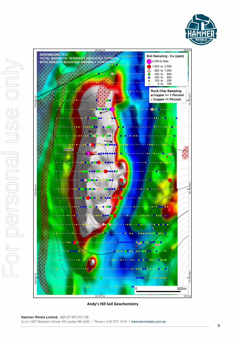
ANDY’S HILL
Andy’s Hill is located 5km south of Overlander North. Rock outcrop above the magnetic and gravity
anomalies consists of red rock altered and gossanous calcareous sediments of the Corella Formation. The
area is characterised by a large zone of strong “red rock” alteration and anomalous copper-in-soil response.
The magnetic response peaks at 7000nT and is approximately 1800 by 600 metres in extent. The gravity
survey delineated an anomaly approximately 650 x 350 metres in extent (at the 3.8mgal level) with a peak
response of approximately 3.9mgal.
Previous drilling has intercepted extensive red rock alteration with copper sulphides at Andy’s Hill. AHD001
drilled in 2011 was terminated in a zone of strong red rock alteration at 494.5m after intersecting 298m @
0.1% Cu within strongly magnetic, altered and brecciated sediments. AHD001 also contained elevated gold,
cobalt and the rare earth elements (REE’s) with lanthanum (up to 0.56%) and cerium (up to 0.72%).
Preliminary gravity modelling indicates two bodies with SG’s of up to 4.5g/cm3 with their top at
approximately 100m below surface. Previous drill holes were either too shallow or in the case of AHD001
passed between the two modelled higher density bodies within the system. A down hole EM survey of
AHD001 indicated an off-hole conductor to the south of the hole in the vicinity of the larger gravity feature.
Hammer considers this work to be highly encouraging and confirms the potential of Andy’s Hill to host
significant mineralisation within the alteration envelope.
For
per
sona
l use
onl
y

7
Andy’s Hill Anomaly
Andy’s Hill modelled Long Section (looking West)
For
per
sona
l use
onl
y

8
Core Photo AH-001 (309.20-317.3m) showing pervasive red albite and patchy dark green actinolite alteration.
For
per
sona
l use
onl
y
9
Andy’s Hill Soil Geochemistry
For
per
sona
l use
onl
y

10
DRONFIELD
The Dronfield magnetic and gravity anomalies are located approximately 25km southeast of Overlander on
EPM18084 which is subject to a farm-in agreement with Kabiri Resources Pty Ltd. The Dronfield anomaly is
located on the northern contact of the Williams Granite contact with the Argylla Formation.
Hammer has recently completed a detailed gravity survey and is currently extending the existing detailed
ground magnetics survey to enable modelling of the magnetic and gravity anomalies. The finalization of the
gravity and magnetic modelling should occur within the next month.
SIGNIFICANCE OF RESULTS AND FUTURE PROGRAM
Hammer considers the recent exploration work has significantly advanced the prospectivity of its Mount Isa Project for large IOCG deposits. The Company now has a range of targets which share characteristics favorable for IOCG mineralisation:
Coincident or closely associated magnetic and gravity anomalies;
A location close to or within felsic intrusive complexes;
Surface geology showing strong red-rock magnetite alteration;
Elevated copper in surface geochemical sampling; and
Copper mineralisation in nearby drilling.
Overlander North, Andy’s Hill, Scalper and Dronfield are high priority IOCG targets for Hammer. The targets will be further modelled and refined followed by drilling as a matter of priority.
- ENDS -
For further information, please contact:
Alex Hewlett
Executive Director
Hammer Metals
Tel: +61 8 9271 0149
Media:
Karen Oswald
Marko Communications
Tel: + 61 423 602 353
For
per
sona
l use
onl
y

11
Competent Person’s Statements:
Historic Exploration Results
The information in this report as it relates to exploration results and geology first reported prior to 1 December 2013 was reviewed by Mr John Downing, who is a Member of the Australian Institute of Geoscientists and a full time employee of the Company. Mr Downing has sufficient experience which is relevant to the style of mineralisation and type of deposit under consideration and to the activity which he is undertaking to qualify as a Competent Person as defined in the 2004 Edition of the 'Australasian Code for Reporting of Exploration Results, Mineral Resources and Ore Reserves'. Mr Downing consents to the inclusion in the report of the matters based on the information in the form and context in which it appears.
This information was prepared and first disclosed under the JORC Code 2004. It has not been updated since to comply with the JORC Code 2012 on the basis that the information has not materially changed since it was last reported.
Exploration Results – Overlander, Andy’s Hill and Dronfield
The information in this report as it relates to exploration results and geology was compiled by Mr John Downing, who is a Member of the Australian Institute of Geoscientists and a full time employee of the Company. Mr Downing has sufficient experience which is relevant to the style of mineralisation and type of deposit under consideration and to the activity which he is undertaking to qualify as a Competent Person as defined in the 2012 Edition of the 'Australasian Code for Reporting of Exploration Results, Mineral Resources and Ore Reserves'. Mr Downing consents to the inclusion in the report of the matters based on the information in the form and context in which it appears.
For
per
sona
l use
onl
y

12
JORC Code, 2012 Edition
Table 1 report – Overlander, Andy’s Hill and
Dronfield Geophysical Modelling
Section 1 Sampling Techniques and Data
(Criteria in this section apply to all succeeding sections in this information release.)
Criteria JORC Code explanation Commentary
Sampling techniques
Nature and quality of sampling (eg cut channels, random chips, or specific specialised industry standard measurement tools appropriate to the minerals under investigation, such as down hole gamma sondes, or handheld XRF instruments, etc). These examples should not be taken as limiting the broad meaning of sampling.
Include reference to measures taken to ensure sample representivity and the appropriate calibration of any measurement tools or systems used.
Aspects of the determination of mineralisation that are Material to the Public Report.
In cases where ‘industry standard’ work has been done this would be relatively simple (eg ‘reverse circulation drilling was used to obtain 1 m samples from which 3 kg was pulverised to produce a 30 g charge for fire assay’). In other cases more explanation may be required, such as where there is coarse gold that has inherent sampling problems. Unusual commodities or mineralisation types (eg submarine nodules) may warrant disclosure of detailed information.
The primary subject of this release is to report on the results of geophysical modelling over Overlander, Andy’s Hill and Dronfield Prospects. The modelling builds on the acquisition of gravity and magnetics data which was completed during October. The release also describes a hole drilled at Andy’s Hill (AH-001).
The ground Gravity Survey was conducted on 400 centres with 200 metre infill and select zones of 100 metre detailed readings to enable depth modelling. The gravity was undertaken by Haines Surveys Pty Ltd utilising a Scintrex CG-5 Autograv Gravity meter which has an accuracy of 0.01 mgal. Locations were captured using a Trimble 5000 GPS receiver and post processed to achieve 5cm vertical and horizontal accuracy.
The Magnetics Survey was undertaken by Fugro Airborne Surveys using a Diamond DA-42 aircraft, housing a Scintrex CS-3 Caesium Vapour Magnetometer, Billingsley TFM100-1E 3-Axis Vector Magnetometer and an Exploranium GR820 Gamma-ray spectrometer. Horizontal location information was captured to GPS accuracy and post processed to enable 1-2 meter accuracy. Altitude information was captured using a radar altimeter, the accuracy of which is less than 5m but strongly dependant on vegetation cover. Data was collected at around 7m spacing on 50m line spacing.
AH-001: Drilling information where
For
per
sona
l use
onl
y

13
Criteria JORC Code explanation Commentary
mentioned pertains to AH-001 which was drilled by Syndicated Metals (SMD) in 2011 and reported to the ASX on 9/1/2012.
The quoted intercept from AH-001 pertains to the results from assaying conducted by Syndicated Metals Limited in 2011. This was done using an OME drilling Pty Ltd top drive rig drilling HQ core. Core was half split and selected 1m samples submitted for analysis. Analysis was conducted by Australian Laboratory Services. 84 metres were analysed for gold by Fire Assay with AAS finish on a 50 gram charge. The same samples were analysed by ICPAES (with aqua regia digest) reporting a 35 element suite A further 340 metres were analysed for gold by Fire Assay with AAS finish on a 50 gram charge. The same samples were analysed by ICPAES (with 4 acid digest) reporting a 33 element suite. Also these samples were analysed by ICPMS (lithium Borate fusion) reporting a 24 element suite. The latter method concentrated on REE analysis.
Drilling techniques
Drill type (eg core, reverse circulation, open-hole hammer, rotary air blast, auger, Bangka, sonic, etc) and details (eg core diameter, triple or standard tube, depth of diamond tails, face-sampling bit or other type, whether core is oriented and if so, by what method, etc).
AH-001: Diamond HQ Core
Drill sample recovery
Method of recording and assessing core and chip sample recoveries and results assessed.
Measures taken to maximise sample recovery and ensure representative nature of the samples.
Whether a relationship exists between sample recovery and grade and whether sample bias may have occurred due to preferential loss/gain of fine/coarse material.
AH-001: Sample recovery was determined through direct measurement of core.
No recovery bias noted in geological logs. F
or p
erso
nal u
se o
nly
14
Criteria JORC Code explanation Commentary
Logging Whether core and chip samples have been geologically and geotechnically logged to a level of detail to support appropriate Mineral Resource estimation, mining studies and metallurgical studies.
Whether logging is qualitative or quantitative in nature. Core (or costean, channel, etc) photography.
The total length and percentage of the relevant intersections logged.
AH-001: An assessment of the information available suggests that the level of detail recorded would support AH-001 being included in a mineral resource estimation along with other drill holes. Core was quantitatively assayed, qualitatively logged, photographed and SG analysis was regularly conducted using the weight air-weight water method.
Sub-sampling techniques and sample preparation
If core, whether cut or sawn and whether quarter, half or all core taken.
If non-core, whether riffled, tube sampled, rotary split, etc and whether sampled wet or dry.
For all sample types, the nature, quality and appropriateness of the sample preparation technique.
Quality control procedures adopted for all sub-sampling stages to maximise representivity of samples.
Measures taken to ensure that the sampling is representative of the in situ material collected, including for instance results for field duplicate/second-half sampling.
Whether sample sizes are appropriate to the grain size of the material being sampled.
AH-001: Half HQ Core was used for assaying.
Quality of assay data and laboratory tests
The nature, quality and appropriateness of the assaying and laboratory procedures used and whether the technique is considered partial or total.
For geophysical tools, spectrometers, handheld XRF instruments, etc, the parameters used in determining the analysis including instrument make and model, reading times, calibrations factors applied and their derivation, etc.
Nature of quality control procedures adopted (eg standards, blanks, duplicates, external laboratory checks) and whether acceptable levels of accuracy (ie lack of bias) and precision have been established.
AH-001: From the information reviewed the assaying of AH-001 was well conducted. The methodology is detailed above. Two passes of analysis occurred, the first with aqua regia digest and the second using the more reliable 4 acid digest. The frequency of standards and blanks inserted with the assays from this hole is not recorded.
The gravity was undertaken by Haines Surveys Pty Ltd utilising a Scintrex CG-5 Autograv Gravity meter which has an accuracy of 0.01 mgal. Locations were captured using a Trimble 5000 GPS receiver and post processed to achieve 5cm vertical and horizontal accuracy. Control points in the areas surveyed were established from existing trig stations and
For
per
sona
l use
onl
y

15
Criteria JORC Code explanation Commentary
benchmarks. Where this was not possible the Geoscience Australia AUSPOS processing facility was used for control. Gravity control was established relative to local control stations. Haines Surveys conducted repeat readings at a minimum frequency of 2%.
The Magnetics Survey was undertaken by Fugro Airborne Surveys using a Diamond DA-42 aircraft, housing a Scintrex CS-3 Caesium Vapour Magnetometer, Billingsley TFM100-1E 3-Axis Vector Magnetometer and an Exploranium GR820 Gamma-ray spectrometer. Horizontal location information was captured to GPS accuracy and post processed to enable 1-2 meter accuracy. Altitude information was captured using a radar altimeter, the accuracy of which is less than 5m but strongly dependant on vegetation cover. Data was collected at around 7m spacing on 50m line spacing. Daily calibrations of equipment were performed.
Verification of sampling and assaying
The verification of significant intersections by either independent or alternative company personnel.
The use of twinned holes.
Documentation of primary data, data entry procedures, data verification, data storage (physical and electronic) protocols.
Discuss any adjustment to assay data.
AH-001: As the data from this tenement has come to Hammer Metals through a sale agreement, Hammer personnel have verified the AH-001 assays against original lab reports. Hammer data is stored in a thoroughly verified database. No adjustments have been made to the primary assay results for this hole.
Gravity: All readings were transferred to Haines personnel on a daily basis for review. The data was also transferred to Southern Geoscience Consultants and Hammer Metals for further examination and verification.
For the magnetics survey, data verification was conducted daily. Data was also transferred to Fugros office in Perth.
Location of data points
Accuracy and quality of surveys used to locate drill holes (collar and down-hole surveys), trenches, mine workings and other locations used in Mineral Resource estimation.
Specification of the grid system used.
AH-001 was captured using DGPS in GDA94 Zone 54 and AHD elevation.
Gravity Station locations were captured using a Trimble 5000 GPS receiver and post processed to achieve 5cm vertical and horizontal
For
per
sona
l use
onl
y
16
Criteria JORC Code explanation Commentary
Quality and adequacy of topographic control.
accuracy.
Magnetics data capture is discussed above.
Data spacing and distribution
Data spacing for reporting of Exploration Results.
Whether the data spacing and distribution is sufficient to establish the degree of geological and grade continuity appropriate for the Mineral Resource and Ore Reserve estimation procedure(s) and classifications applied.
Whether sample compositing has been applied.
AH-001 is an exploration hole and cannot be used to establish geological or grade continuity without further drilling.
The ground gravity survey was conducted on 400 centres with 200 metre infill and select zones of 100 metre detailed readings to enable depth modelling
The aeromagnetic data was collected at around 7m spacing on 50m line spacing.
The geophysical data density is considered appropriate to the target type being sought.
Orientation of data in relation to geological structure
Whether the orientation of sampling achieves unbiased sampling of possible structures and the extent to which this is known, considering the deposit type.
If the relationship between the drilling orientation and the orientation of key mineralised structures is considered to have introduced a sampling bias, this should be assessed and reported if material.
AH-001: The direction of the drill hole is perpendicular to the main axis of magnetic elongation at Andy’s Hill.
The aeromagnetic flight line direction and gravity station layout was oriented perpendicular to major structural features.
Sample security
The measures taken to ensure sample security.
Gravity data was transferred daily to Haines Surveys and then onto Southern Geoscience for independent review. Data was also transferred daily to Hammer personnel for digital storage.
Aeromagnetic data was transferred daily to Fugro Perth Office.
Audits or reviews
The results of any audits or reviews of sampling techniques and data.
As mentioned above as gravity data was collected, daily data review was conducted by Southern Geoscience Consultants for independent review during the execution of the program. F
or p
erso
nal u
se o
nly

17
Section 2 Reporting of Exploration Results
(Criteria listed in the preceding section also apply to this section.)
Criteria JORC Code explanation Commentary
Mineral tenement and land tenure status
Type, reference name/number, location and ownership including agreements or material issues with third parties such as joint ventures, partnerships, overriding royalties, native title interests, historical sites, wilderness or national park and environmental settings.
The security of the tenure held at the time of reporting along with any known impediments to obtaining a licence to operate in the area.
The survey was conducted over two Exploration Permits.
The Andy’s Hill and Overlander surveys are located within EPM14232, which is held 100% by Mt Dockerell Mining Pty Ltd (a 100% owned subsidiary of Hammer Metals Limited).
The Dronfield Survey was conducted on EPM18084 which is the subject of a farm-in with Kabiri Resources Pty Ltd. Hammer Metals can earn an 80% interest in the tenement through expenditure of $250,000.
The above-mentioned tenements are in good standing with the Qld DME
Exploration done by other parties
Acknowledgment and appraisal of exploration by other parties.
AH-001 was drilled by Syndicated Metals (SMD) in 2011 (and reported to the ASX on 9/1/2012). The tenement on which AH-001 is located was subsequently purchased by Hammer Metals Limited.
At Dronfield detailed ground magnetics (depicted in the report figure) was conducted by Arimco Mining Pty Ltd in 1995. The digital data from this program has been reviewed and modelled. The program was undertaken using a Geometrics G-856 magnetometer with a reading spacing of 25m on 100m East-West oriented lines.
Surface soil and rock chip sampling shown in the attached figures was conducted by Cerro Resources Limited, Syndicated Metals Limited and Hammer Resources Limited.
Geology Deposit type, geological setting and style of mineralisation.
The mineralisation style discussed in this release is Iron-Oxide Copper Gold (IOCG). The closest example of this style is the Ernest Henry Deposit to the north of Cloncurry.
At Overlander North and Andy’s Hill the host rocks are strongly red rock-magnetite altered calc-silicates of the Corella Formation. At Dronfield the host is strongly red rock-magnetite altered granite of the Wimberu
For
per
sona
l use
onl
y
18
Criteria JORC Code explanation Commentary
Granite (Williams Suite).
Drill hole Information
A summary of all information material to the understanding of the exploration results including a tabulation of the following information for all Material drill holes: o easting and northing of the drill
hole collar o elevation or RL (Reduced Level –
elevation above sea level in metres) of the drill hole collar
o dip and azimuth of the hole o down hole length and interception
depth o hole length.
If the exclusion of this information is justified on the basis that the information is not Material and this exclusion does not detract from the understanding of the report, the Competent Person should clearly explain why this is the case.
Details for AH-001 are as follows:
E (GDA94 Zone54) – 384710
N (GDA94 Zone54) – 7669400
RL (AHD) – 495
Dip (Degrees) - -55
Azimuth (Relative to GDA94) – 090
Total Depth (m) – 494.5
Other holes are shown on the figures for the Overlander Prospect. The holes for the Overlander North Resource area are not specifically relevant to the suspected IOCG system which may be present below the Overlander North Gravity-Magnetics Anomaly. This drilling has been previously reported to the ASX.
At Andy’s Hill (apart from AH-001) the holes shown in the figures have not intersected the geophysical models and are therefore not considered material to the topic that this release addresses.
Data aggregation methods
In reporting Exploration Results, weighting averaging techniques, maximum and/or minimum grade truncations (eg cutting of high grades) and cut-off grades are usually Material and should be stated.
Where aggregate intercepts incorporate short lengths of high grade results and longer lengths of low grade results, the procedure used for such aggregation should be stated and some typical examples of such aggregations should be shown in detail.
The assumptions used for any reporting of metal equivalent values should be clearly stated.
AH-001: The intercept quoted in this report was derived from a previous ASX release done by Hammer Metals Limited on May 20th 2014
The quoted average grade was checked against the Hammer Database to verify its authenticity. The cut-off grade for the intercept was 0.1% Copper. No top cut was applied.
No metal equivalents have been used in this release.
Relationship between mineralisation widths and intercept lengths
These relationships are particularly important in the reporting of Exploration Results.
If the geometry of the mineralisation with respect to the drill hole angle is known, its nature should be reported.
If it is not known and only the down hole lengths are reported, there should be a clear statement to this
The relationship between the mineralised interval in AH-001 and the geometry of mineralisation at Andy’s Hill is uncertain as the drill hole density is insufficient to enable continuity of grade to be established.
For
per
sona
l use
onl
y

19
Criteria JORC Code explanation Commentary
effect (eg ‘down hole length, true width not known’).
Diagrams Appropriate maps and sections (with scales) and tabulations of intercepts should be included for any significant discovery being reported These should include, but not be limited to a plan view of drill hole collar locations and appropriate sectional views.
See attached figures
Balanced reporting
Where comprehensive reporting of all Exploration Results is not practicable, representative reporting of both low and high grades and/or widths should be practiced to avoid misleading reporting of Exploration Results.
All holes which have been drilled at the relevant prospects are shown on the attached figures. Apart from AH-001 the holes are not considered material to the subject of this report.
All compiled rock chip sampling is shown on the attached figures and significant results are highlighted.
Similarly soil sampling undertaken at Andys Hill is shown in its entirety.
Other substantive exploration data
Other exploration data, if meaningful and material, should be reported including (but not limited to): geological observations; geophysical survey results; geochemical survey results; bulk samples – size and method of treatment; metallurgical test results; bulk density, groundwater, geotechnical and rock characteristics; potential deleterious or contaminating substances.
Refer to the release.
Further work The nature and scale of planned further work (eg tests for lateral extensions or depth extensions or large-scale step-out drilling).
Diagrams clearly highlighting the areas of possible extensions, including the main geological interpretations and future drilling areas, provided this information is not commercially sensitive.
It is envisioned that the three areas will be further examined with a view to defining drill targets as soon as possible.
For
per
sona
l use
onl
y