mainstreetmaps web gis user guide€¦ · web gis user guide - copyright mainstreetgis, llc - page...
TRANSCRIPT

Web GIS User Guide - Copyright MainStreetGIS, LLC - www.mainstreetgis.com Page 1 of 15
MainStreetMaps Web GIS User Guide
by MainStreetGIS, LLC www.mainstreetgis.com
Updated 11/11/2017

Web GIS User Guide - Copyright MainStreetGIS, LLC - www.mainstreetgis.com Page 2 of 15
Table of Contents
Suggestions……………………………page 3
Tool Bar…...……………………………page 4
Search……………………………….…page 5
Parcel Information………….…………page 6
Base Maps…………………………..…page 7
Layers Tab…………………………..…page 8
Property Tab……………………..….…page 9
Selection Tab…………………..………page 10
Street View Tab…………………..……page 11
Tax Maps Tab…………………….……page 12
Other Maps Tab…………………..……page 13
Abutters Mailing Lists…………….……page 14
Internal GIS Toolbar…………………...page 15

Web GIS User Guide - Copyright MainStreetGIS, LLC - www.mainstreetgis.com Page 3 of 15
Suggestions Here are some suggestions for setting up your web browser for use with the Web GIS:
❖ We highly suggest using the free Google Chrome web browser, however all major browsers should be
compatible, including Internet Explorer, Safari, and Firefox.
❖ For Abutters Lists and other features, you will need to “Always allow pop-ups from
mainstreetmaps.com”. If you are asked if you would like to show pop-ups, please choose Yes or OK
and select the “Always allow” option. You may need to reload the page or your web browser itself for
this change to take effect. Note: Abutters List mailing labels will not display unless you have allowed
pop-ups.
❖ For printing, please use the Print icon shown on the Web GIS toolbar to select a layout. Once the
layout is displayed, use your browser’s Print Preview to view additional options. Set the layout to
Portrait or Landscape depending and you will probably want to set the zoom level to 100% so that there
is No Scaling on the page.
❖ Set your browser’s zoom level for the web page to 100% so that the map shows at its original size.
❖ JavaScript must be enabled. (Usually not an issue, but might be worth checking if it looks like the
application did not fully load and a map is not drawn)
❖ In Windows, if text is overlapping or the layout doesn’t look right, please try setting your Screen Font
size to 100% or “normal”. You will find this setting in the Display Properties for Windows.
❖ If something is not working as it should, please try clearing your browser history and reload the Web
GIS so that the latest version of the Web GIS is loaded.
Web GIS User Guide - Copyright MainStreetGIS, LLC - www.mainstreetgis.com Page 4 of 15
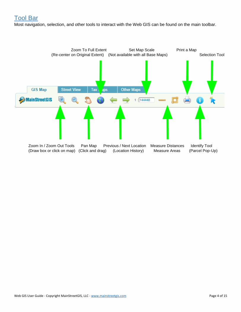
Tool Bar Most navigation, selection, and other tools to interact with the Web GIS can be found on the main toolbar.
Zoom To Full Extent Set Map Scale Print a Map
(Re-center on Original Extent) (Not available with all Base Maps) Selection Tool
Zoom In / Zoom Out Tools Pan Map Previous / Next Location Measure Distances Identify Tool
(Draw box or click on map) (Click and drag) (Location History) Measure Areas (Parcel Pop-Up)

Web GIS User Guide - Copyright MainStreetGIS, LLC - www.mainstreetgis.com Page 5 of 15
Search To search for a parcel or property, use the Search bar in the upper-right of the Web GIS. The Address, Parcel
ID, and Owner searches will locate particular parcels, while the Google search option uses Google to search
for a location.
Using the Search bar is usually the first step to locating a Parcel and accessing its Property Record Card, Tax
Map, or running an Abutters Notification List. Once a parcel is found, buttons under the Property Tab offer
access to tools and information specific to the parcel.
Hint: Enter just a street name with the Google search option to quickly locate a street.
Note: The Google search for an address is often an approximate location based on distance along the street
segment.
Type your search in the Search
Bar and hit Enter.
Choose a Search method.
The Address and Parcel ID
search methods offer a drop-
down list that offers suggestions
as you type.

Web GIS User Guide - Copyright MainStreetGIS, LLC - www.mainstreetgis.com Page 6 of 15
Parcel Information With the Identify Tool activated, click on a Property / Parcel to view a Pop-Up with links to more information.
Identify Tool
Activate this tool before
clicking on a parcel to view
Pop-up.
Select Parcel
Adds this parcel to the
Property Tab for more options
and Abutters Lists.
Property Card and Other Links
Link to Property Record Cards,
Permitting (where available),
and other Documents for the
active parcel.

Web GIS User Guide - Copyright MainStreetGIS, LLC - www.mainstreetgis.com Page 7 of 15
Base Maps The Base Map menu is located near the top of the Web GIS and provides access to Satellite Imagery, Aerial
Photos, Orthophotography, USGS Topo Maps, Google Maps, Hillshades, Elevation Models, and more.
Base Maps are drawn underneath all other layers such as those found under the Layers tab.
The source and date are shown along with the name of each base map when possible.
Base Map menu
Web GIS User Guide - Copyright MainStreetGIS, LLC - www.mainstreetgis.com Page 8 of 15
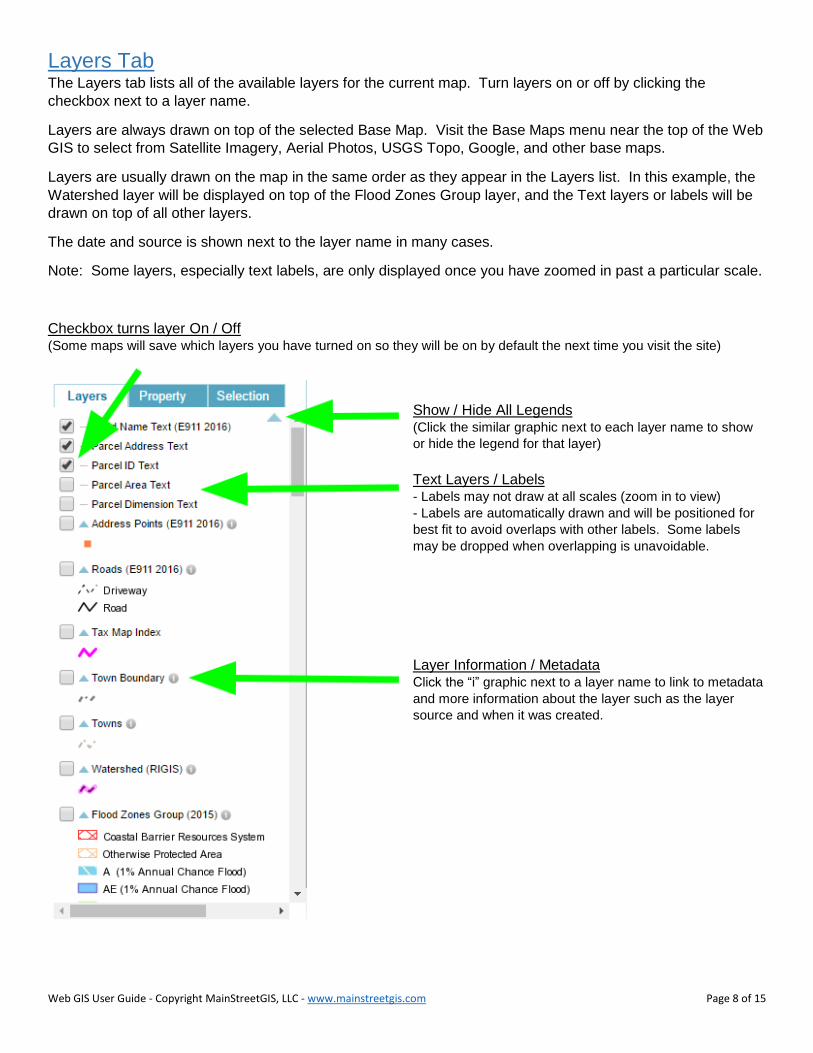
Layers Tab The Layers tab lists all of the available layers for the current map. Turn layers on or off by clicking the
checkbox next to a layer name.
Layers are always drawn on top of the selected Base Map. Visit the Base Maps menu near the top of the Web
GIS to select from Satellite Imagery, Aerial Photos, USGS Topo, Google, and other base maps.
Layers are usually drawn on the map in the same order as they appear in the Layers list. In this example, the
Watershed layer will be displayed on top of the Flood Zones Group layer, and the Text layers or labels will be
drawn on top of all other layers.
The date and source is shown next to the layer name in many cases.
Note: Some layers, especially text labels, are only displayed once you have zoomed in past a particular scale.
Checkbox turns layer On / Off (Some maps will save which layers you have turned on so they will be on by default the next time you visit the site)
Show / Hide All Legends (Click the similar graphic next to each layer name to show
or hide the legend for that layer)
Text Layers / Labels - Labels may not draw at all scales (zoom in to view)
- Labels are automatically drawn and will be positioned for
best fit to avoid overlaps with other labels. Some labels
may be dropped when overlapping is unavoidable.
Layer Information / Metadata Click the “i” graphic next to a layer name to link to metadata
and more information about the layer such as the layer
source and when it was created.

Web GIS User Guide - Copyright MainStreetGIS, LLC - www.mainstreetgis.com Page 9 of 15
Property Tab The Property Tab provides access to links and tools specific to the Active Property. The Active Property can
be set by either performing a Search using the Search Bar in the upper-right of the Web GIS or by activating
the Identify Tool, clicking on a parcel, and then clicking Select from within the pop-up.
Property Tab
(Available options will vary)
Zoom To
Locate the Active Property on the GIS Map.
Property Card
Link to the MainStreetGIS Property Card for the Active Property.
Abutters List
Generate a mailing list of all properties within a specific distance of the Active Property.
Tax Map
View the Tax Map for the Active Property in PDF format.
Property Details
Link to a simple text description of each assessment record for the Active Property. In the case of
condominiums or other multiple address per parcel situations, multiple records will be displayed (one for each
unit).
Report an Issue
Let us know of any incorrect information to help us improve the data.

Web GIS User Guide - Copyright MainStreetGIS, LLC - www.mainstreetgis.com Page 10 of 15
Selection Tab The Selection Tab shows all parcels or properties in your current selection set. Selected parcels are
highlighted in Yellow on the map.
Activate the Selection Tool and then click on a parcel to add it to the selection set. To remove a parcel from
the selection set, click on the selected parcel again or click the red X in the selection list.
Download Selection
as a Table (.csv) Activate Selection Tool
Clear Mailing Labels
Selection Zoom To Selection
Click the red X to Click on any item in the selection set to locate its corresponding parcel on the map
remove a parcel from
the selection set
Click the blue “i” icon
to view more information
about the property

Web GIS User Guide - Copyright MainStreetGIS, LLC - www.mainstreetgis.com Page 11 of 15
Street View Tab The Street View Tab offers a combined Google Street View and Bing Bird’s Eye that work in tandem and are
located to the last position on the GIS Map Tab.
Google Street View allows you to walk up and down a street and view properties as seen from the roadway.
Some municipalities may have limited Street View.
Bind Bird’s Eye offers aerial and satellite imagery with a handy angled or “oblique” view that allows you to see
properties from an angle (where available).
Click the Street View Tab to access Google Street View and Bing Bird’s Eye
Street View Street View Bing Bird’s Eye Bing Bird’s Eye
Walk Up and Down Street Rotate View Drag to relocate Rotate View

Web GIS User Guide - Copyright MainStreetGIS, LLC - www.mainstreetgis.com Page 12 of 15
Tax Maps Tab The Tax Maps Tab offers links to the latest official full size tax maps in PDF format.
Tax Maps Tab
Activate the Tax Maps Tab to show
links to the latest official Tax Maps in
PDF format. Click a link to view or
download each individual tax map or
a combined set.
Use the Tax Map Index map to
locate the tax map for a particular
property or a section of town.

Web GIS User Guide - Copyright MainStreetGIS, LLC - www.mainstreetgis.com Page 13 of 15
Other Maps Tab The Other Maps Tab offers links to other official town maps in PDF format. Here you may find Zoning Maps,
Street Index Maps, Cemetery Maps, FEMA Flood Zone Maps, Voting Districts, Polling Places, and more.
Other Maps Tab
Offers links to other official maps in
PDF format

Web GIS User Guide - Copyright MainStreetGIS, LLC - www.mainstreetgis.com Page 14 of 15
Abutters Notification Lists Our abutters notification tool generates a set of mailing labels for all properties within a specified distance from
the active property.
Important: You must allow pop-ups from mainstreetmaps.com in order to view the mailing labels. This may
be done in your browser’s settings area, or by running an abutters list and watching your browser for a
message about a blocked pop-up. It should then give you the option to allow pop-ups for
mainstreetmaps.com. Be sure to choose “always allow”, reload the website, and then run your abutters list
again. The pop-up setting should be saved for future use.
To select abutters and view mailing labels, please follow these steps:
- Search for a property using the Search bar in the upper right, or click on a property and then click
Select from within the pop-up. This will add a property to the Property tab on the left.
- Click the Abutters List button from the Property tab.
- Enter a buffer distance (usually in Feet). This will select all properties within a distance of the active
property.
- Click OK and the map will add all properties within the buffer zone to the Selection tab and will also
open a new tab or window with the mailing labels.
The mailing labels are formatted for the Avery mailing label template 5160.
In some browsers (Chrome, Firefox) the mailing labels will automatically set the margins and page breaks for
the Avery 5160 mailing label template when you use your browser’s Print Preview.
Hint #1: You may add or remove parcels from the abutters selection by activating the Selection tool and then
clicking on a parcel. See the Selection tab for the current list of selected parcels.
Hint #2: You may also create a mailing list at any time without using the Abutters List button by using the
Selection tool and then clicking on the Mail button under the Selection tab.
Hint #3: To create a PDF document of your mailing labels, try printing to PDF from your browser. You may be
able to choose a PDF generator as one of your printers in your browser’s print settings.

Web GIS User Guide - Copyright MainStreetGIS, LLC - www.mainstreetgis.com Page 15 of 15
Tool Bar (Internal WebGIS Only)
To Draw, make sure the Drawing button is activated.
Select a drawing tool from the toolbar to be used on screen.
Draw Point Draw Box
Draw Line Draw Freehand
Draw Polygon Clear Drawings
To Buffer, make sure the Buffer button is activated.
Select a buffer tool from the toolbar to be used on screen.
Select Features to Buffer Clear Buffers
Apply Buffer Zoom to Buffers
Buffer Point