maiden 895koz jorc 2012 resource and 131koz …...2017/12/21 · samrec estimates completed by...
TRANSCRIPT
1
Red 5 Limited ABN 73 068 647 610 ASX: RED Shares on Issue: 1,241M
Level 2, 35 Ventnor Avenue West Perth 6005 Western Australia Tel: (+61) 8 9322 4455 Fax: (+61) 8 9481 5950 Web: www.red5limited.com Investor enquiries: [email protected]
21 December 2017
Maiden 895koz JORC 2012 Resource and 131koz Ore Reserve for Darlot Gold Mine Sets Foundation for Gold
Production Outlook for 2018
Increases Group Mineral Resources in the Eastern Goldfields of WA to 1.3Moz1 including the King of the Hills Project where underground mining is set to commence early next year
Key Points
• Maiden JORC 2012 Mineral Resource estimate completed for the 100%-owned Darlot Gold Mine:
Measured, Indicated and Inferred Mineral Resource of 6.0Mt @ 4.6 g/t Au for 895koz of contained gold
• New Mineral Resource delivers a significant increase in contained gold ounces over the previously reported SAMREC estimates completed by previous owner, a subsidiary of Gold Fields Limited (1.2Mt @ 5.97g/t Au for 224,000oz2).
• JORC 2012 Resource includes a maiden Probable Ore Reserve of 1.0Mt @ 4.0 g/t Au for 131koz of contained gold, delivering additional mine life for the Darlot mining operations.
• Exploration and grade control programs to commence at Darlot in early 2018 to further expand and de-risk the Resource and Reserve base, with numerous high-priority targets identified.
Operations, Development and Financial Update • Five gold shipments for 12,300oz achieved at Darlot since the completion of the acquisition on 2 October
2017 with gold production for the December 2017 Quarter expected to be at the upper end of guidance (13-16koz).
• The remnant mining program at Darlot is delivering positive results, with stopes in the first three extensions to existing mining areas (Metzke, Walters and Bradman) exceeding expectations in terms of mined tonnes and grade.
• The Darlot mill is also performing well with opportunities identified to increase capacity. This work is ongoing.
• The first stockpiled ore from King of the Hills (KOTH) has been successfully trucked and milled at Darlot.
• The underground mining contract for the KOTH project has been awarded to experienced underground mining contractor, Pit N Portal Mining Services, who have commenced mobilisation to site. Following receipt of final mining permit approvals, mining is expected to commence in January 2018.
2018 Production Guidance and Outlook • Gold production3 for calendar year 2018 is expected to be in the range of 85-95,000oz.
1 Combined New Mineral Resource (JORC 2012) at Darlot (see below) and Saracen Resource and Reserve Statement 2 August
2017 for KOTH as at 30 June 2017 2 Gold Fields Resource and Reserve Supplement 2016 p.69 and p.71 as previously reported by Red 5 on 3 August 2017 3 Guidance is subject to market and operating conditions and no unforeseen circumstances occurring. Potential production
and throughput rates are subject to a range of contingencies which may affect performance.
For
per
sona
l use
onl
y

2
Red 5 Limited (“Red 5” or “the Company”) (ASX: RED) is pleased to advise that its Eastern Goldfields consolidation strategy is delivering results on several fronts, with the completion of a maiden 895,000 ounce JORC 2012 Mineral Resource and maiden 131,000 ounce Ore Reserve for the 100%-owned Darlot Gold Mine in Western Australia (Figure 1) providing the foundation for the Group’s first production guidance outlook for its Australian operations for calendar year 2018.
Figure 1: Location of Darlot Gold Mine, Western Australia showing
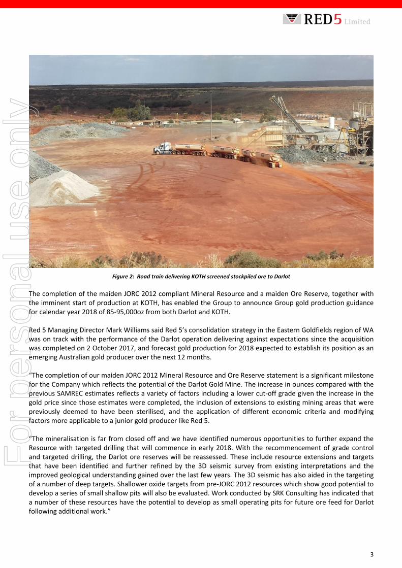
historical production from key gold deposits in the region Mineral Resources for the Darlot Gold Mine are now reported for the first time under the JORC Code since the 1990s, with Mineral Resources now reported in accordance with the JORC 2012 Code, a significant milestone for the Group which follows an extensive re-evaluation of the previously reported SAMREC estimates completed by the previous owner, a subsidiary of Gold Fields Limited (1.2Mt at 5.97g/t Au for 224,000oz²). The significant increase in the Resource base is primarily due to the inclusion of areas deemed by the previous owner for SAMREC estimate reporting purposes to have been sterilised, including numerous areas which are now being targeted as part of Red 5’s mining strategy at Darlot together with reduced mining cut off grades and additional areas not quoted previously – which is already underway and delivering promising results. Together with previously reported JORC 2012 Mineral Resources for the KOTH Project, this increases the Group’s JORC Mineral Resource inventory of Measured, Indicated and Inferred in Western Australia’s Eastern Goldfields to 1.3 million ounces. The Company is also pleased to provide an update on operations at Darlot, where production for the December 2017 Quarter is on track to be at the upper end of the previously reported guidance range of 13-16,000oz. Red 5 has awarded an underground mining contract for the KOTH project to Pit N Portal Mining Services and expects mining to commence at KOTH in January 2018, providing a second supplementary source of ore feed to the Darlot mill. The first ore from the medium to low grade stockpiles at KOTH has been successfully trucked and milled at Darlot. Contractor, MLG Oz, screened and transported the ore to Darlot as shown in Figure 2.
For
per
sona
l use
onl
y
3
Figure 2: Road train delivering KOTH screened stockpiled ore to Darlot
The completion of the maiden JORC 2012 compliant Mineral Resource and a maiden Ore Reserve, together with the imminent start of production at KOTH, has enabled the Group to announce Group gold production guidance for calendar year 2018 of 85-95,000oz from both Darlot and KOTH. Red 5 Managing Director Mark Williams said Red 5’s consolidation strategy in the Eastern Goldfields region of WA was on track with the performance of the Darlot operation delivering against expectations since the acquisition was completed on 2 October 2017, and forecast gold production for 2018 expected to establish its position as an emerging Australian gold producer over the next 12 months. “The completion of our maiden JORC 2012 Mineral Resource and Ore Reserve statement is a significant milestone for the Company which reflects the potential of the Darlot Gold Mine. The increase in ounces compared with the previous SAMREC estimates reflects a variety of factors including a lower cut-off grade given the increase in the gold price since those estimates were completed, the inclusion of extensions to existing mining areas that were previously deemed to have been sterilised, and the application of different economic criteria and modifying factors more applicable to a junior gold producer like Red 5. “The mineralisation is far from closed off and we have identified numerous opportunities to further expand the Resource with targeted drilling that will commence in early 2018. With the recommencement of grade control and targeted drilling, the Darlot ore reserves will be reassessed. These include resource extensions and targets that have been identified and further refined by the 3D seismic survey from existing interpretations and the improved geological understanding gained over the last few years. The 3D seismic has also aided in the targeting of a number of deep targets. Shallower oxide targets from pre-JORC 2012 resources which show good potential to develop a series of small shallow pits will also be evaluated. Work conducted by SRK Consulting has indicated that a number of these resources have the potential to develop as small operating pits for future ore feed for Darlot following additional work.”
For
per
sona
l use
onl
y
4
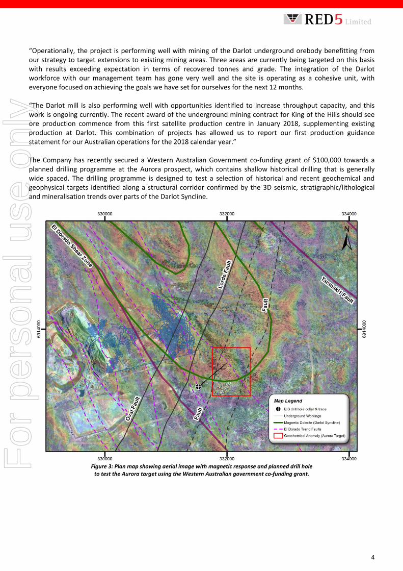
“Operationally, the project is performing well with mining of the Darlot underground orebody benefitting from our strategy to target extensions to existing mining areas. Three areas are currently being targeted on this basis with results exceeding expectation in terms of recovered tonnes and grade. The integration of the Darlot workforce with our management team has gone very well and the site is operating as a cohesive unit, with everyone focused on achieving the goals we have set for ourselves for the next 12 months. “The Darlot mill is also performing well with opportunities identified to increase throughput capacity, and this work is ongoing currently. The recent award of the underground mining contract for King of the Hills should see ore production commence from this first satellite production centre in January 2018, supplementing existing production at Darlot. This combination of projects has allowed us to report our first production guidance statement for our Australian operations for the 2018 calendar year.” The Company has recently secured a Western Australian Government co-funding grant of $100,000 towards a planned drilling programme at the Aurora prospect, which contains shallow historical drilling that is generally wide spaced. The drilling programme is designed to test a selection of historical and recent geochemical and geophysical targets identified along a structural corridor confirmed by the 3D seismic, stratigraphic/lithological and mineralisation trends over parts of the Darlot Syncline.
Figure 3: Plan map showing aerial image with magnetic response and planned drill hole
to test the Aurora target using the Western Australian government co-funding grant.
For
per
sona
l use
onl
y

5
Figure 4: Cross-section (looking northwest) through the Aurora target area showing trace of the co-funded
planned drill hole with structural and stratigraphic target features. Darlot Gold Mine – JORC 2012 Mineral Resource The Mineral Resource estimates for the Darlot Gold Mine are reported by Red 5 in accordance with the JORC 2012 Code (Table 1). A summary of the data and methodologies supporting the Mineral Resource estimates form part of this ASX release, including separate JORC Table 1’s for each of the deposits reported. Table 1 – Mineral Resource estimate, Darlot Gold Mine, for the Deposit by resource area and JORC Classification.
Mineral Resource, Darlot Gold Mine
Area Au cut off g/t JORC 2012 Classification Tonnes kt Au g/t Au koz
Centenary 2.0 Measured 7.1 10.1 2 Indicated 1,633 5.5 289 Inferred 1,028 4.7 154
Pedersen 2.0 Indicated 1,394 3.9 177 Inferred 613 3.5 69
Lords South Lower 2.0 Indicated 548 4.6 81 Inferred 38 4.1 5
Centenary Depth Analogue Lower 2.0 Indicated 167 8.0 43 Inferred 113 6.3 23
Burswood 2.0 Indicated 162 4.8 25 Inferred 295 2.9 28
Sub-total Measured 7.1 10.1 2 Sub-total Indicated 3,904 4.9 615 Sub-total Inferred 2,086 4.1 278
Sub Total Measured + Indicated 3,911 4.9 617
Total All 5,997 4.6 895
For
per
sona
l use
onl
y

6
Notes on Mineral Resources:
1. Mineral Resources are quoted as inclusive of Ore Reserves. 2. Discrepancy in summation may occur due to rounding. 3. The updated JORC 2012 Underground Reserve expected marginal cut off will range between <2.0 to 2.3 g/t Au. 4. The figures take into account mining depletion as at 27 November 2017. 5. Figures do not include closing estimated ROM stocks of 13,200t @ 3.8g/t for 1,612oz as at 27 November 2017. 6. Refer to Appendix 1 for the JORC 2012 Table 1 Most of the Mineral Resources quoted in Table 1 are currently being mined, and the Burswood deposit is adjacent to current underground workings. A 402-camp is located adjacent to the mine site and an experienced workforce is employed.
Figure 5: Isometric view of all Darlot lodes, Darlot open pit and underground development
Summary of Darlot Mineral Resource Estimates
Geology and Geological Interpretation The Darlot lodes are considered to be part of an Archean hydrothermal fault-vein deposit with many similar characteristics with other deposits within the Yilgarn Craton, namely host rock type and nature of hydrothermal alteration; however, it is atypical in being relatively flat-lying rather than steeply dipping. Felsic porphyries and lamprophyre intrusions are encountered throughout the deposit. The major host for gold mineralisation is the Mount Pickering Dolerite. Five Mineral Resource models have been prepared for the purposes of this announcement, namely Centenary, Pedersen, Lords South Lower, Centenary Depth Analogue Oval and Burswood. Gold mineralisation occurs within sub-horizontal to steeply-dipping stacked quartz veins bounded by deposit scale faults. The interpretations supporting the geological models are predominantly based upon drill-hole samples and geological mapping from the development drives. Drilling Techniques A total of 4,826 diamond drill (DD) holes (607,464m), 501 RCDD drill holes (Reverse Circulation (RC)) collars with diamond core tails (163,7784m), 707 Reverse Circulation drill holes (66,567m) and 8,334 face samples (50,082m) support the Mineral Resource.
For
per
sona
l use
onl
y
7
Sampling and Sub-Sampling Techniques DD core sample lengths can be variable in a mineralised zone, though usually no larger than one-metre. Surface DD is generally NQ2 or HQ diameter core, while underground DD is usually NQ2 or LTK60. DD samples were geotechnically and geologically logged and sample recoveries calculated. Where possible, core is sampled by cutting in half and samples bagged and dispatched to the analytical laboratory. RC drill samples were geologically logged and sampled on one-metre intervals using similar codes to DD. Samples of 1 m drill length were passed through a rig-mounted cyclone and collected in large plastic bags positioned beneath the cyclone. Representative 3kg samples were collected in calico bags for despatch to the analytical laboratory. Underground face sampling was carried out by the geologist painting a sample line orthogonal to the dip of the quartz veining and sampled according to geological intervals. Sample Analysis Method Primary assaying of DD and face samples was undertaken by ALS Kalgoorlie for considerable time up to the present time. Analysis is by 50g fire assay (FA) with Atomic Absorption Spectrometer (AAS) finish to 0.01 g/t detection limit.
Estimation Methodology All geological interpretations were prepared in Darlot Mine Grid. Geological interpretations are based upon underground mapping, geological logs (all sample data) and gold assays. Multiple lodes modelled for each deposit are grouped into separate geological domains. Barren lamprophyres cross-cut some of the lodes and naturally deplete the Mineral Resource. Sample data were composited to 1m intervals, very high gold grades were top-cut, to statistically analysed and estimated into a block model using Ordinary Kriging (OK) and Simple Kriging (SK). A density of 2.90 t/m3 was applied to all blocks. The models were validated to ensure that blocks were correctly coded for geological domains, and that estimated gold grades honoured the surrounding drill assays.
Cut-off Grades All geological interpretations were completed by site geologists based on both grade and lithology, and an approximate Au lower cut-off of around 0.5 g/t. The Mineral Resources are reported above a cut-off grade of 2.0 g/t which is determined from the expected marginal underground mining cost.
Classification The Mineral Resource models are classified as a combination of Indicated and Inferred. The classification of the Mineral Resource took into account the geological understanding of the deposit, quality of the samples, quality and quantity of density data, drill-hole spacing, and the quality of the block grade estimates. Geological understanding and quality of samples is sufficient to assume geological and grade continuity in the Indicated volumes.
For classification of Indicated Resources, a drill spacing of <40 x 40m was generally required, and for classification of Inferred Resources, <60 x 60m was required. The Indicated resource blocks were assigned the OK estimated grades while the Inferred resource blocks were assigned the SK estimated grade.
Other Material Modifying Factors No significant amounts of deleterious elements have historically been encountered at Darlot or estimated in the Darlot Mineral Resource models, and hence have never been considered for estimation in the Mineral Resource. Pyrite does not occur in significant enough quantities to be considered for acid mine drainage (AMD) considerations.
For
per
sona
l use
onl
y
8
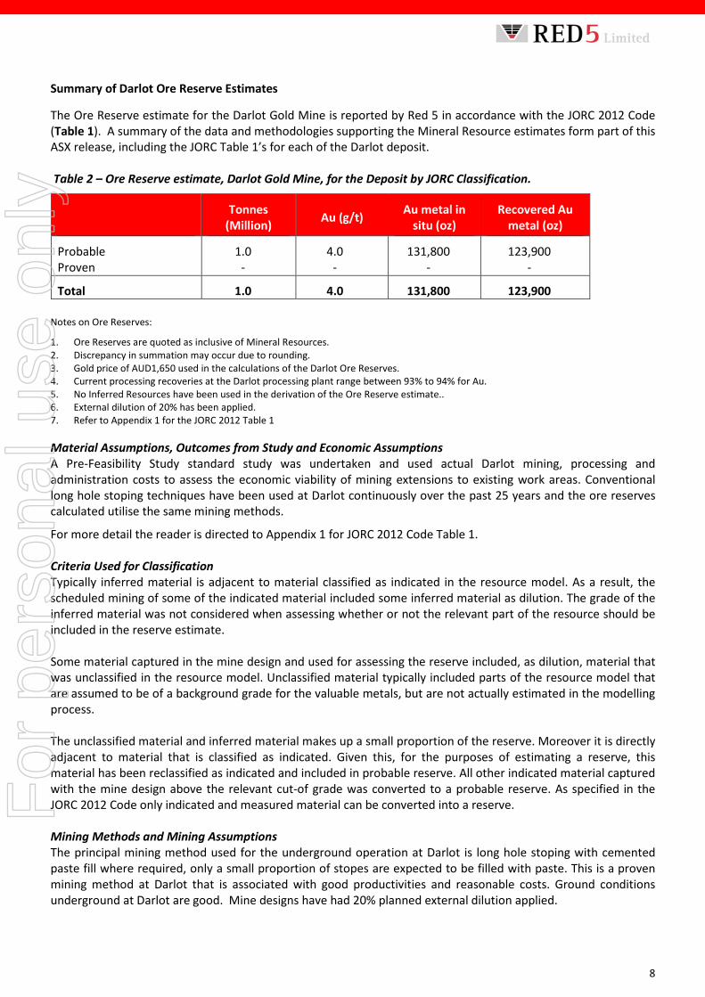
Summary of Darlot Ore Reserve Estimates
The Ore Reserve estimate for the Darlot Gold Mine is reported by Red 5 in accordance with the JORC 2012 Code (Table 1). A summary of the data and methodologies supporting the Mineral Resource estimates form part of this ASX release, including the JORC Table 1’s for each of the Darlot deposit. Table 2 – Ore Reserve estimate, Darlot Gold Mine, for the Deposit by JORC Classification.
Tonnes (Million) Au (g/t) Au metal in
situ (oz) Recovered Au
metal (oz)
Probable 1.0 4.0 131,800 123,900 Proven - - - -
Total 1.0 4.0 131,800 123,900 Notes on Ore Reserves:
1. Ore Reserves are quoted as inclusive of Mineral Resources. 2. Discrepancy in summation may occur due to rounding. 3. Gold price of AUD1,650 used in the calculations of the Darlot Ore Reserves. 4. Current processing recoveries at the Darlot processing plant range between 93% to 94% for Au. 5. No Inferred Resources have been used in the derivation of the Ore Reserve estimate.. 6. External dilution of 20% has been applied. 7. Refer to Appendix 1 for the JORC 2012 Table 1 Material Assumptions, Outcomes from Study and Economic Assumptions A Pre-Feasibility Study standard study was undertaken and used actual Darlot mining, processing and administration costs to assess the economic viability of mining extensions to existing work areas. Conventional long hole stoping techniques have been used at Darlot continuously over the past 25 years and the ore reserves calculated utilise the same mining methods.
For more detail the reader is directed to Appendix 1 for JORC 2012 Code Table 1. Criteria Used for Classification Typically inferred material is adjacent to material classified as indicated in the resource model. As a result, the scheduled mining of some of the indicated material included some inferred material as dilution. The grade of the inferred material was not considered when assessing whether or not the relevant part of the resource should be included in the reserve estimate. Some material captured in the mine design and used for assessing the reserve included, as dilution, material that was unclassified in the resource model. Unclassified material typically included parts of the resource model that are assumed to be of a background grade for the valuable metals, but are not actually estimated in the modelling process. The unclassified material and inferred material makes up a small proportion of the reserve. Moreover it is directly adjacent to material that is classified as indicated. Given this, for the purposes of estimating a reserve, this material has been reclassified as indicated and included in probable reserve. All other indicated material captured with the mine design above the relevant cut-of grade was converted to a probable reserve. As specified in the JORC 2012 Code only indicated and measured material can be converted into a reserve. Mining Methods and Mining Assumptions The principal mining method used for the underground operation at Darlot is long hole stoping with cemented paste fill where required, only a small proportion of stopes are expected to be filled with paste. This is a proven mining method at Darlot that is associated with good productivities and reasonable costs. Ground conditions underground at Darlot are good. Mine designs have had 20% planned external dilution applied.
For
per
sona
l use
onl
y
9
Processing Methods and Processing Assumptions Ore from the Darlot underground operation will be processed at the existing 0.83Mtpa gravity and carbon-in-leach (CIL) processing facility. Metallurgical recoveries of 94% have been used which is in line with historic gold recoveries at Darlot. Cut-Off Grade A cut-off grade assessment was completed indicating an optimal cut-off grade of 2.3 g/t of Au should be applied for the purposes of developing a reserve estimate. Some low grade material has to be mined as development in order to access the resource above the economic cut-off grade. This material is not economic by itself; however, given that it has to be mined and transported to surface the valuable metal need only cover the cost of treatment. As a result this material has been included for the purposes of estimating the reserve. The cut-off grade for this material is 0.5 g/t Au. Block Model Estimation Methodology All geological interpretations were prepared in Darlot Mine Grid. Geological interpretations are based upon underground mapping, geological logs (all sample data) and gold assays. Multiple lodes modelled for each deposit are grouped into separate geological domains. Barren lamprophyres cross-cut some of the lodes and naturally deplete the Mineral Resource. Sample data were composited to 1m intervals, very high gold grades were top-cut, to statistically analysed and estimated into a block model using Ordinary Kriging (OK) and Simple Kriging (SK). A density of 2.90 t/m3 was applied to all blocks. The models were validated to ensure that blocks were correctly coded for geological domains, and that estimated gold grades honoured the surrounding drill assays. Material Modifying Factors and Approvals The Darlot Underground Mine has been operated continuously since 1995 with operating parameters well understood with all regulatory approvals in place. Existing mine infrastructure includes a 402 person accommodation village, airstrip, 0.83mtpa processing plant, power station and office/workshop infrastructure required to run the Darlot Gold Mine. Minor capital development and sustaining capital expenditure will be required to extract these reserves. These resources and reserves have been compiled out of Red 5’s normal estimation cycle, which is to report reserves as at 30 June each year. The Company expects to review these resources and reserves mid-2018. Red 5 has elected to report resources and reserves at this time to demonstrate some of the potential of the recently acquired Darlot asset. To be included in reserves, Red 5 has to design stopes around the ore blocks. Given the acquisition of the asset, Red 5 has had limited time for this design process, which has restricted the generation of stope design and optimisation and has impacted the tonnage and grade of the reserves being reported. Because the Darlot asset was operating while in a sale process, the normal cycle of exploration and infill drilling was interrupted and this has impacted the generation of both resources and reserves which return to Red 5’s normal estimation. OPERATIONS, DEVELOPMENT AND FINANCIAL UPDATE The Darlot mining operation was acquired by Red 5 as an operating mine site, with the acquisition completed on 2 October 2017. The Company’s Stage 1 development plan is to maximise throughput at the Darlot mill over an initial 3 year period by processing ore from both the Darlot and KOTH underground mining operations. Stage 2 of the Strategy will centre on increasing the Company’s Resource base in the Eastern Goldfields through regional exploration within the 25,700ha tenement footprint, as well as assessing additional business development opportunities. Extensions to existing mining areas program (Remnant Mining) Mining a number of different areas in the upper and mid-levels of the mine which had previously been considered to have been sterilised was a key part of Red 5’s Stage 1 development plan.
For
per
sona
l use
onl
y
10
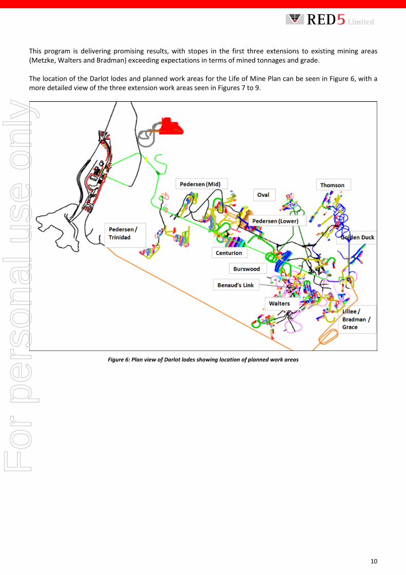
This program is delivering promising results, with stopes in the first three extensions to existing mining areas (Metzke, Walters and Bradman) exceeding expectations in terms of mined tonnages and grade. The location of the Darlot lodes and planned work areas for the Life of Mine Plan can be seen in Figure 6, with a more detailed view of the three extension work areas seen in Figures 7 to 9.
Figure 6: Plan view of Darlot lodes showing location of planned work areas
For
per
sona
l use
onl
y

11
Figure 7: Isometric view of the Marsh 1108 Bulk stope
The Marsh 1108 stope, as seen in Figure 7 was a developed block of ore identified as suitable for a bulk stope with an opportunity to mine 55kt at 1.9 g/t but the final mining shape is expected to produce 86kt at a similar grade for 5.5kozs. This stope is close to half mined out with every indication that the grade is holding up through the process plant.
Figure 8: Bradman 1160 planned stoping area
The Bradman 1160 extension is currently being developed, initial designs contained 16kt at 5g/t however the development grades were quite exceptional through this area with the development face in Figure 8 averaging 7 g/t. The Company is planning to mine 33kt at 5 g/t with an additional 66kt at 3 g/t (Bradman West) identified as being economic and mineable.
For
per
sona
l use
onl
y

12
Figure 9: Walters 980 E Stope
The third extensional work area being developed is the Walters 980 E stope, where a closer inspection and evaluation has doubled the available ounces to be mined from 3.1koz to 6.3koz as seen in Figure 9. The Walters B stope is currently being mined after 19kt was successfully mined out of the W980 A stope. Darlot Mill Performance The Darlot processing plant has been performing strongly, with throughput reaching up to 100 tonnes per hour (tph) which is above the design annualised throughput capacity of 830,000tpa, with recoveries averaging 93.6%. The strong performance of the processing department at Darlot supports Red 5’s strategy of aiming to fully utilise mill capacity in order to reduce unit operating costs. King of the Hills Development Red 5 has awarded the underground mining contract for the KOTH project to experienced underground mining contractors, Pit N Portal Mining Services. The contract is a standard fixed and variable three year mining contract. Pit n Portal will supply all equipment, mining and technical personnel whilst Red 5 will supply power, diesel, accommodation and flights. DMIRS approvals to recommence mining at KOTH have been received and so mining at KOTH is expected to commence in early January 2018, however Pit n Portal have already commenced mobilisation to site and have been managing the dewatering activities at KOTH. In anticipation of this milestone, a parcel of stockpiled, low grade run-of-mine (ROM) ore from KOTH has been transported to Darlot for trial processing to evaluate its metallurgical and blending characteristics. The first 1,000 tonne sample averaged 2 g/t with the ore treated through the Darlot processing plant. Initial results from the heap leach amenability test work recently undertaken on samples of ore from the KOTH project are positive and indicate potential for heap leaching of the lower grade ores. Preliminary Intermittent Bottle Roll (IBR) test work indicate >70% gold recovery is achievable at typical heap leach operating conditions.
For
per
sona
l use
onl
y
13
Based on these positive results further sampling and second stage column leach test work will be scheduled in the New Year and is expected to take approximately three months. Financial The Group’s cash balance, including refined gold held in the metal account, as at 30 November 2017 was $19.6 million. However, this balance does not include a shipment made in early December 2017 of 3,034oz. As previously advised, a working capital debt facility of $10-$15 million is continuing to be actively considered by Red 5. 2018 PRODUCTION GUIDANCE AND OUTLOOK Gold production guidance for the Darlot operations, including from KOTH, for calendar year 2018 is in the range of 85,000-95,000oz, with production for the first quarter of calendar year 2018 expected to be in the range of 16,000-19,000oz. Reporting of All-in Sustaining Costs (AISC) to date will be provided in the quarterly activities report for the December 2017 quarter which is due for release in late January 2018.
ENDS For more information: Investors/Shareholders: Media: Mark Williams, Managing Director Nicholas Read John Tasovac, Chief Financial Officer Read Corporate Red 5 Limited Tel: +61-8 9388 1474 Telephone: +61 8 9322 4455 About Red 5 Limited Red 5 Limited (ASX: RED) is an Australian gold producer an asset portfolio in the Eastern Goldfields region of Western Australia comprising the operating Darlot Gold Mine and the King of the Hills (KOTH) Gold Project. Red 5 holds a commanding 25,700ha footprint in the highly-endowed Leonora-Leinster gold district, one of Australia’s most active gold provinces, an expanding Mineral Resource inventory, gold production and outstanding exploration and growth potential. The Group, through its associated Philippine company Greenstone Resources Corporation also holds interests in the Siana Gold Project, located in the established gold mining region of Surigao del Norte in the Philippines. Mining operations at the Siana Gold Project are currently suspended pending an improvement in operating conditions in the Philippines. Siana retains significant inherent value, including a substantial gold inventory, a modern 1.1Mtpa treatment facility, an open pit mine and a part-developed underground mine.
For
per
sona
l use
onl
y
14
Competent Person’s Statements Mineral Resource Mr Byron Dumpleton, confirms that he is the Competent Person for the Mineral Resources summarised in this report and Mr Dumpleton has read and understood the requirements of the 2012 Edition of the Australasian Code for Reporting of Exploration Results, Mineral Resources and Ore Reserves (JORC Code, 2012 Edition). Mr Dumpleton is a Competent Person as defined by the JORC Code, 2012 Edition, having five years’ experience that is relevant to the style of mineralisation and type of deposit described in this report and to the activity for which he is accepting responsibility. Mr Dumpleton is a Member of the Australian Institute of Geoscientists, No. 1598. Mr Dumpleton is a full time employee of Red 5 Limited. Mr Dumpleton has reviewed this report and consents to the inclusion of the matters based on his supporting information in the form and context in which it appears. Ore Reserve Mr Steve Tombs confirms that he is the Competent Person for the open pit Ore Reserves estimates summarised in this report and Mr Tombs has read and understood the requirements of the 2012 Edition of the Australasian Code for Reporting of Exploration Results, Mineral Resources and Ore Reserves (JORC Code, 2012 Edition). Mr Tombs is a Competent Person as defined by the JORC Code, 2012 Edition, having five years’ experience that is relevant to the style of mineralisation and type of deposit described in the report and to the activity for which he is accepting responsibility. Mr Tombs is a Fellow of the Australasian Institute of Mining and Metallurgy, No. 105785. Mr Tombs is a full time employee of Red 5. Mr Tombs has reviewed this report and consents to the inclusion of the matters based on his supporting information in the form and context in which it appears. Forward-Looking Statements Certain statements made during or in connection with this statement contain or comprise certain forward-looking statements regarding Red 5’s Mineral Resources and Reserves, exploration operations, project development operations, production rates, life of mine, projected cash flow, capital expenditure, operating costs and other economic performance and financial condition as well as general market outlook. Although Red 5 believes that the expectations reflected in such forward-looking statements are reasonable, such expectations are only predictions and are subject to inherent risks and uncertainties which could cause actual values, results, performance or achievements to differ materially from those expressed, implied or projected in any forward looking statements and no assurance can be given that such expectations will prove to have been correct. Accordingly, results could differ materially from those set out in the forward-looking statements as a result of, among other factors, changes in economic and market conditions, delays or changes in project development, success of business and operating initiatives, changes in the regulatory environment and other government actions, fluctuations in metals prices and exchange rates and business and operational risk management. Except for statutory liability which cannot be excluded, each of Red 5, its officers, employees and advisors expressly disclaim any responsibility for the accuracy or completeness of the material contained in this statement and excludes all liability whatsoever (including in negligence) for any loss or damage which may be suffered by any person as a consequence of any information in this statement or any error or omission. Red 5 undertakes no obligation to update publicly or release any revisions to these forward-looking statements to reflect events or circumstances after today's date or to reflect the occurrence of unanticipated events other than required by the Corporations Act and ASX Listing Rules. Accordingly you should not place undue reliance on any forward looking statement.
For
per
sona
l use
onl
y
1
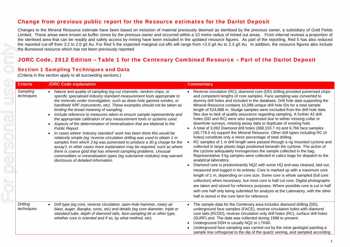
Change from previous public report for the Resource estimates for the Darlot Deposit Changes to the Mineral Resource estimate have been based on inclusion of material previously deemed as sterilised by the previous owner, a subsidiary of Gold Fields Limited. These areas were known as buffer zones by the previous owner and occurred within a 10 metre radius of mined out areas. From internal reviews a proportion of the sterilised area that can be readily and safely access by mining have been included in the updated resource figures. As part of the reporting, Red 5 has also reduced the reported cut-off from 3.2 to 2.0 g/t Au. For Red 5 the expected marginal cut-offs will range from <2.0 g/t Au to 2.3 g/t Au. In addition, the resource figures also include the Burswood resource which has not been previously reported.
JORC Code, 2012 Edition – Table 1 for the Centenary Combined Resource – Part of the Darlot Deposit
Section 1 Sampling Techniques and Data (Criteria in this section apply to all succeeding sections.)
Criteria JORC Code explanation Commentary Sampling techniques
• Nature and quality of sampling (eg cut channels, random chips, or specific specialised industry standard measurement tools appropriate to the minerals under investigation, such as down hole gamma sondes, or handheld XRF instruments, etc). These examples should not be taken as limiting the broad meaning of sampling.
• Include reference to measures taken to ensure sample representivity and the appropriate calibration of any measurement tools or systems used.
• Aspects of the determination of mineralisation that are Material to the Public Report.
• In cases where ‘industry standard’ work has been done this would be relatively simple (eg ‘reverse circulation drilling was used to obtain 1 m samples from which 3 kg was pulverised to produce a 30 g charge for fire assay’). In other cases more explanation may be required, such as where there is coarse gold that has inherent sampling problems. Unusual commodities or mineralisation types (eg submarine nodules) may warrant disclosure of detailed information.
• Reverse circulation (RC), diamond core (DD) drilling provided pulverised chips and competent lengths of core samples. Face sampling was converted to dummy drill holes and included in the database. Drill hole data supporting the Mineral Resource contains 10,098 unique drill hole IDs for a total sample length of 524,888 m. Sludge samples were excluded from the drill hole data files due to lack of quality assurance regarding sampling. A further 42 drill holes (DD and RC) were also suppressed due to wither missing collar or downhole surveys, missing assay data or duplicate of existing hole.
• A total of 3,092 Diamond drill holes (368,103.7 m) and 6,766 face samples (40,778.5 m) support the Mineral Resource. Other drill types including RC (4 holes) constitute only a minor percentage of total drilling.
• RC samples of 1 m drill length were passed through a rig mounted cyclone and collected in large plastic bags positioned beneath the cyclone. The action of the cyclone adequately homogenises the sample collected in the bag. Representative 3 kg samples were collected in calico bags for dispatch to the analytical laboratory.
• Diamond core is predominantly NQ2 with some HQ and was cleaned, laid out, measured and logged in its entirety. Core is marked up with a maximum core length of 1 m, depending on core size. Some core is whole sampled (full core collection) when necessary, but most core is half cut core. Digital photographs are taken and stored for reference purposes. Where possible core is cut in half with one half only being submitted for analysis at the Laboratory, with the other half is stored in the core farm for reference.
Drilling techniques
• Drill type (eg core, reverse circulation, open-hole hammer, rotary air blast, auger, Bangka, sonic, etc) and details (eg core diameter, triple or standard tube, depth of diamond tails, face-sampling bit or other type, whether core is oriented and if so, by what method, etc).
• The sample data for the Centenary area includes diamond drilling (DD), underground face samples (FACE), reverse circulation holes with diamond core tails (RCDD), reverse circulation only drill holes (RC), surface drill holes (SURF) and. The data was collected during 1998 to present.
• Underground DDH is usually NQ2 or LTK60. • Underground face sampling was carried out by the mine geologist painting a
sample line orthogonal to the dip of the quartz veining, and sampled according
For
per
sona
l use
onl
y
2
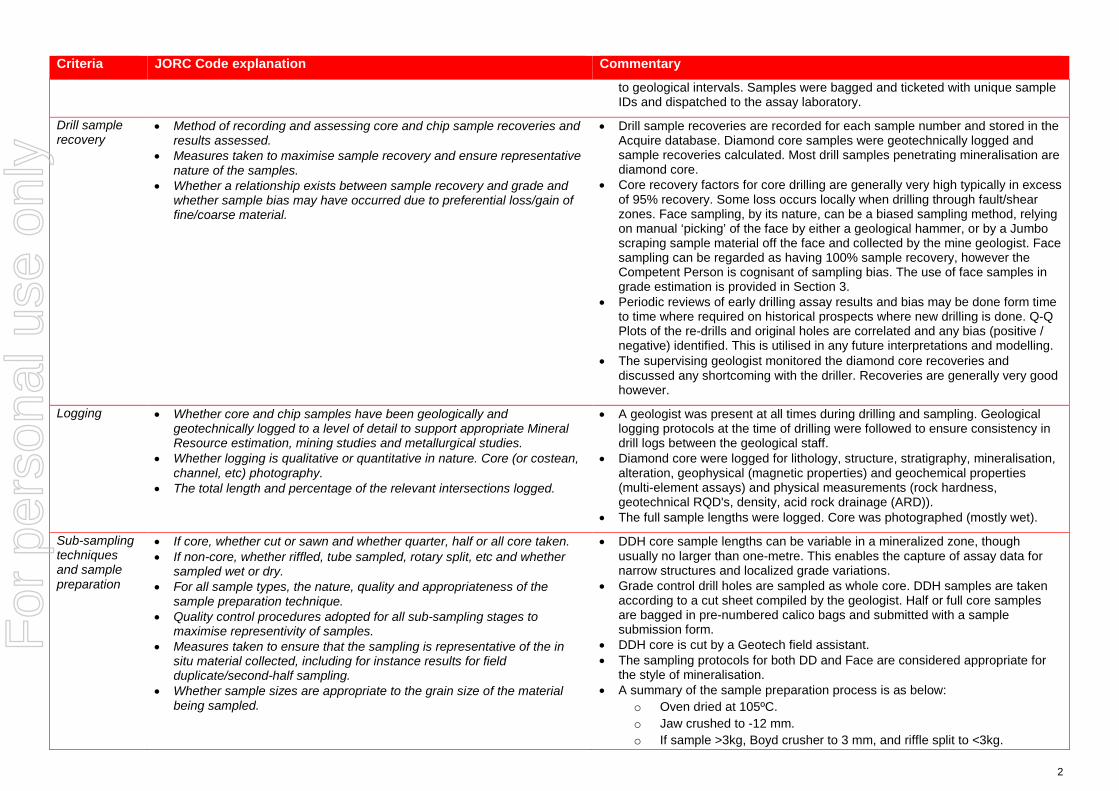
Criteria JORC Code explanation Commentary
to geological intervals. Samples were bagged and ticketed with unique sample IDs and dispatched to the assay laboratory.
Drill sample recovery
• Method of recording and assessing core and chip sample recoveries and results assessed.
• Measures taken to maximise sample recovery and ensure representative nature of the samples.
• Whether a relationship exists between sample recovery and grade and whether sample bias may have occurred due to preferential loss/gain of fine/coarse material.
• Drill sample recoveries are recorded for each sample number and stored in the Acquire database. Diamond core samples were geotechnically logged and sample recoveries calculated. Most drill samples penetrating mineralisation are diamond core.
• Core recovery factors for core drilling are generally very high typically in excess of 95% recovery. Some loss occurs locally when drilling through fault/shear zones. Face sampling, by its nature, can be a biased sampling method, relying on manual ‘picking’ of the face by either a geological hammer, or by a Jumbo scraping sample material off the face and collected by the mine geologist. Face sampling can be regarded as having 100% sample recovery, however the Competent Person is cognisant of sampling bias. The use of face samples in grade estimation is provided in Section 3.
• Periodic reviews of early drilling assay results and bias may be done form time to time where required on historical prospects where new drilling is done. Q-Q Plots of the re-drills and original holes are correlated and any bias (positive / negative) identified. This is utilised in any future interpretations and modelling.
• The supervising geologist monitored the diamond core recoveries and discussed any shortcoming with the driller. Recoveries are generally very good however.
Logging • Whether core and chip samples have been geologically and geotechnically logged to a level of detail to support appropriate Mineral Resource estimation, mining studies and metallurgical studies.
• Whether logging is qualitative or quantitative in nature. Core (or costean, channel, etc) photography.
• The total length and percentage of the relevant intersections logged.
• A geologist was present at all times during drilling and sampling. Geological logging protocols at the time of drilling were followed to ensure consistency in drill logs between the geological staff.
• Diamond core were logged for lithology, structure, stratigraphy, mineralisation, alteration, geophysical (magnetic properties) and geochemical properties (multi-element assays) and physical measurements (rock hardness, geotechnical RQD's, density, acid rock drainage (ARD)).
• The full sample lengths were logged. Core was photographed (mostly wet).
Sub-sampling techniques and sample preparation
• If core, whether cut or sawn and whether quarter, half or all core taken. • If non-core, whether riffled, tube sampled, rotary split, etc and whether
sampled wet or dry. • For all sample types, the nature, quality and appropriateness of the
sample preparation technique. • Quality control procedures adopted for all sub-sampling stages to
maximise representivity of samples. • Measures taken to ensure that the sampling is representative of the in
situ material collected, including for instance results for field duplicate/second-half sampling.
• Whether sample sizes are appropriate to the grain size of the material being sampled.
• DDH core sample lengths can be variable in a mineralized zone, though usually no larger than one-metre. This enables the capture of assay data for narrow structures and localized grade variations.
• Grade control drill holes are sampled as whole core. DDH samples are taken according to a cut sheet compiled by the geologist. Half or full core samples are bagged in pre-numbered calico bags and submitted with a sample submission form.
• DDH core is cut by a Geotech field assistant. • The sampling protocols for both DD and Face are considered appropriate for
the style of mineralisation. • A summary of the sample preparation process is as below:
o Oven dried at 105ºC. o Jaw crushed to -12 mm. o If sample >3kg, Boyd crusher to 3 mm, and riffle split to <3kg.
For
per
sona
l use
onl
y
3
Criteria JORC Code explanation Commentary
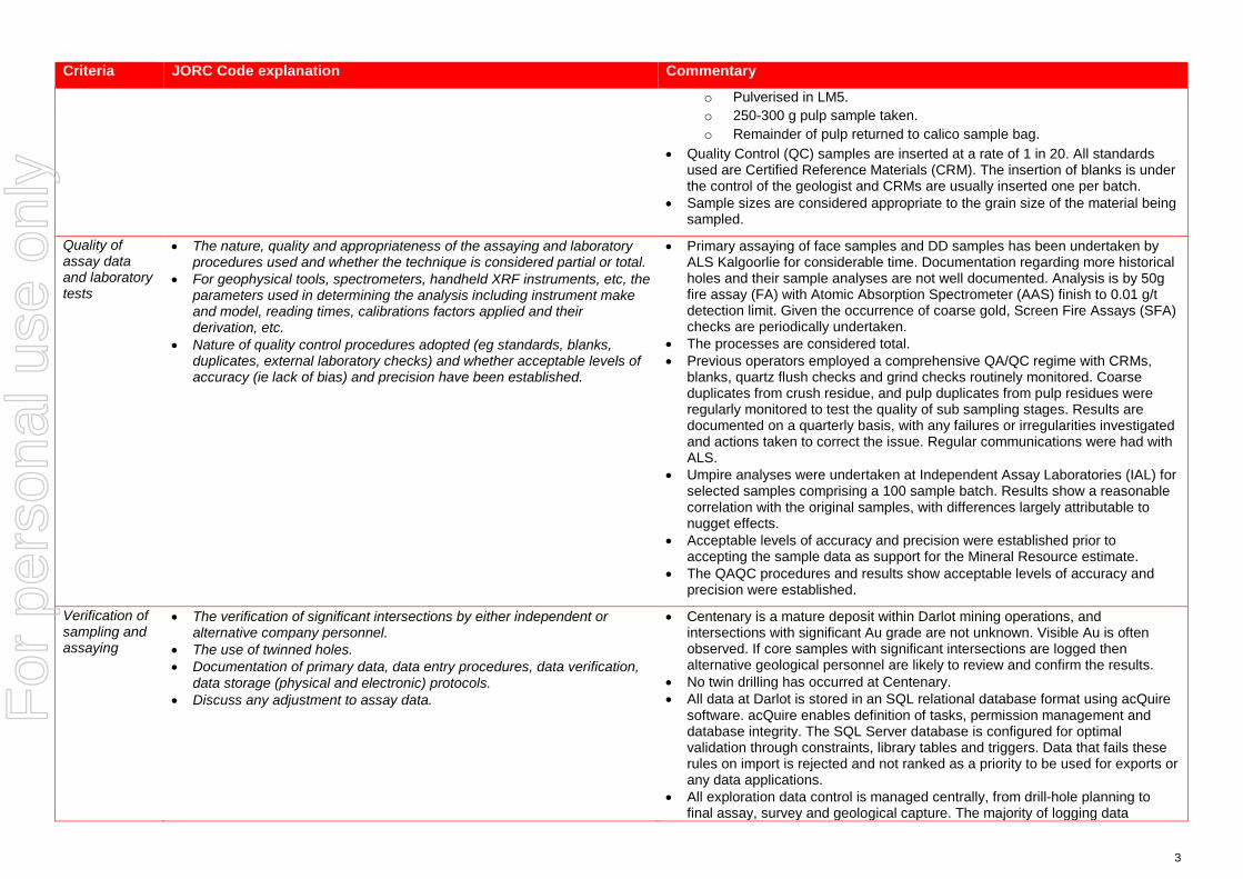
o Pulverised in LM5. o 250-300 g pulp sample taken. o Remainder of pulp returned to calico sample bag.
• Quality Control (QC) samples are inserted at a rate of 1 in 20. All standards used are Certified Reference Materials (CRM). The insertion of blanks is under the control of the geologist and CRMs are usually inserted one per batch.
• Sample sizes are considered appropriate to the grain size of the material being sampled.
Quality of assay data and laboratory tests
• The nature, quality and appropriateness of the assaying and laboratory procedures used and whether the technique is considered partial or total.
• For geophysical tools, spectrometers, handheld XRF instruments, etc, the parameters used in determining the analysis including instrument make and model, reading times, calibrations factors applied and their derivation, etc.
• Nature of quality control procedures adopted (eg standards, blanks, duplicates, external laboratory checks) and whether acceptable levels of accuracy (ie lack of bias) and precision have been established.
• Primary assaying of face samples and DD samples has been undertaken by ALS Kalgoorlie for considerable time. Documentation regarding more historical holes and their sample analyses are not well documented. Analysis is by 50g fire assay (FA) with Atomic Absorption Spectrometer (AAS) finish to 0.01 g/t detection limit. Given the occurrence of coarse gold, Screen Fire Assays (SFA) checks are periodically undertaken.
• The processes are considered total. • Previous operators employed a comprehensive QA/QC regime with CRMs,
blanks, quartz flush checks and grind checks routinely monitored. Coarse duplicates from crush residue, and pulp duplicates from pulp residues were regularly monitored to test the quality of sub sampling stages. Results are documented on a quarterly basis, with any failures or irregularities investigated and actions taken to correct the issue. Regular communications were had with ALS.
• Umpire analyses were undertaken at Independent Assay Laboratories (IAL) for selected samples comprising a 100 sample batch. Results show a reasonable correlation with the original samples, with differences largely attributable to nugget effects.
• Acceptable levels of accuracy and precision were established prior to accepting the sample data as support for the Mineral Resource estimate.
• The QAQC procedures and results show acceptable levels of accuracy and precision were established.
Verification of sampling and assaying
• The verification of significant intersections by either independent or alternative company personnel.
• The use of twinned holes. • Documentation of primary data, data entry procedures, data verification,
data storage (physical and electronic) protocols. • Discuss any adjustment to assay data.
• Centenary is a mature deposit within Darlot mining operations, and intersections with significant Au grade are not unknown. Visible Au is often observed. If core samples with significant intersections are logged then alternative geological personnel are likely to review and confirm the results.
• No twin drilling has occurred at Centenary. • All data at Darlot is stored in an SQL relational database format using acQuire
software. acQuire enables definition of tasks, permission management and database integrity. The SQL Server database is configured for optimal validation through constraints, library tables and triggers. Data that fails these rules on import is rejected and not ranked as a priority to be used for exports or any data applications.
• All exploration data control is managed centrally, from drill-hole planning to final assay, survey and geological capture. The majority of logging data
For
per
sona
l use
onl
y

4
Criteria JORC Code explanation Commentary
(lithology, alteration, and structural characteristics of core and percussion chips) is captured directly either by manual or to customised digital logging tools with stringent validation and data entry constraints. Geologists load data in the acquire database where initial validation of the data occurs. The data are uploaded into the database by the geologist after which ranking of the data happen based on multiple QAQC and validation rules.
• All assay data is uploaded into the database in a text format known as a sif. These files include detailed information about the batch, methods, units, detection limits and elements assayed. The file also includes all QC data in the sequence of analysis. The assay data is stored in a flattened format to ensure all required information is stored for each sample, and that multiple assay results are stored for each sample.
• Data validation is controlled via rules, library tables and triggers. Once all data for a drill-hole have been entered into the database, the geologist responsible for the drilling program validates each drill-hole. A standard validation trigger in the acquire database run queries against the data, which includes checks for; incorrect collar locations, testing for overlapping, missing or incorrect down-hole surveys, and incorrect collar location.
• A digital certified assay certificate in Adobe PDF format is backed up on the Darlot server on a regular schedule. A copy of the database also resides on the Red 5 back-up server in Perth.
• The database is secure and password protected by the Database Administrator to prevent accidental or malicious adjustment to data.
• No adjustments are made to the data.
Location of data points
• Accuracy and quality of surveys used to locate drill holes (collar and down-hole surveys), trenches, mine workings and other locations used in Mineral Resource estimation.
• Specification of the grid system used. • Quality and adequacy of topographic control.
• Collars are marked out pre-drilling and surveyed post-drilling by licensed surveyors. All recent DD holes were surveyed down the hole by Reflex non-magnetic multi shot gyro survey. Down hole surveys are routinely undertaken by the drilling contractor and verified by the mine geologist.
• Drill hole collars are located respective to the local mine grid and to the overall property in UTM MGA94-Zone51. Mine grid north is 44° west of north Australian Map Grid, and all mining Mineral Resource and Ore Reserve work is carried out in Mine Grid. Reduced Level (RL) for surface drilling is calculated by adding 1,000 m to surface elevation, while the underground RL is calculated by taking the surface RL minus the vertical depth to the point being referenced.
• Underground voids are surveyed by mine surveyors. The survey control on these voids is considered adequate to support the depletion of the Mineral Resource model.
Data spacing and distribution
• Data spacing for reporting of Exploration Results. • Whether the data spacing and distribution is sufficient to establish the
degree of geological and grade continuity appropriate for the Mineral Resource and Ore Reserve estimation procedure(s) and classifications applied.
• Whether sample compositing has been applied.
• Typical drill spacing in Centenary ranges up to 30x30m, which is reduced to around 15x15m in the grade control areas.
• The Competent Person considers the data spacing to be sufficient to establish the degree of geological and grade continuity appropriate for the Mineral Resource classification categories adopted for Centenary.
• Samples were not composited prior to dispatch for analyses.
For
per
sona
l use
onl
y
5
Criteria JORC Code explanation Commentary
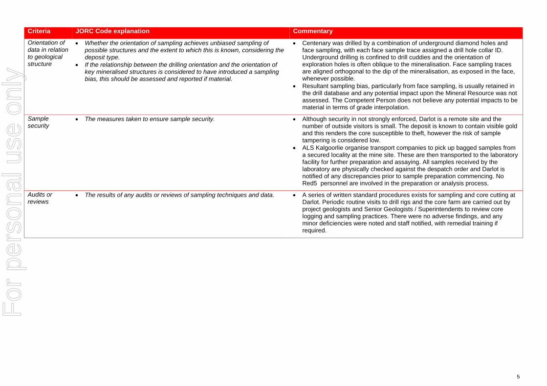
Orientation of data in relation to geological structure
• Whether the orientation of sampling achieves unbiased sampling of possible structures and the extent to which this is known, considering the deposit type.
• If the relationship between the drilling orientation and the orientation of key mineralised structures is considered to have introduced a sampling bias, this should be assessed and reported if material.
• Centenary was drilled by a combination of underground diamond holes and face sampling, with each face sample trace assigned a drill hole collar ID. Underground drilling is confined to drill cuddies and the orientation of exploration holes is often oblique to the mineralisation. Face sampling traces are aligned orthogonal to the dip of the mineralisation, as exposed in the face, whenever possible.
• Resultant sampling bias, particularly from face sampling, is usually retained in the drill database and any potential impact upon the Mineral Resource was not assessed. The Competent Person does not believe any potential impacts to be material in terms of grade interpolation.
Sample security
• The measures taken to ensure sample security. • Although security in not strongly enforced, Darlot is a remote site and the number of outside visitors is small. The deposit is known to contain visible gold and this renders the core susceptible to theft, however the risk of sample tampering is considered low.
• ALS Kalgoorlie organise transport companies to pick up bagged samples from a secured locality at the mine site. These are then transported to the laboratory facility for further preparation and assaying. All samples received by the laboratory are physically checked against the despatch order and Darlot is notified of any discrepancies prior to sample preparation commencing. No Red5 personnel are involved in the preparation or analysis process.
Audits or reviews
• The results of any audits or reviews of sampling techniques and data. • A series of written standard procedures exists for sampling and core cutting at Darlot. Periodic routine visits to drill rigs and the core farm are carried out by project geologists and Senior Geologists / Superintendents to review core logging and sampling practices. There were no adverse findings, and any minor deficiencies were noted and staff notified, with remedial training if required.
For
per
sona
l use
onl
y

6
Section 2 Reporting of Exploration Results (Criteria listed in the preceding section also apply to this section.)
Criteria JORC Code explanation Commentary
Mineral tenement and land tenure status
• Type, reference name/number, location and ownership including agreements or material issues with third parties such as joint ventures, partnerships, overriding royalties, native title interests, historical sites, wilderness or national park and environmental settings.
• The security of the tenure held at the time of reporting along with any known impediments to obtaining a licence to operate in the area.
• Centenary is covered by mining lease M37/155 and held by Darlot Mining Company Limited. This lease covers 1,000Ha and was granted on 18/7/1988, renewed 17/7/2009 and to be renewed on 17/7/2030. Current rental has been paid ($17,600) and minimum annual expenditure of $100,000 is required and is being met. There are no Joint Ventures over the tenure and no native title claims. There are no other agreements in place apart from a 2.5% royalty for all gold sold, payable to the Government of Western Australia.
Exploration done by other parties
• Acknowledgment and appraisal of exploration by other parties. • Centenary is part of the Darlot Gold Mine, which has a long history of gold mining and exploration. Alluvial gold was first mined in the area in 1894 with a consequent gold rush between 1895 and 1913. Total gold production from this time is unknown. Limited gold production occurred between 1935 and 1980.
• Modern exploration of Darlot commenced in the period in the 1970’s, with intensive exploration by Sundowner Minerals NL during 1986 to 1988. Darlot open pit mining commenced in 1988, and Sundowner was acquired by Plutonic Resources in 1992, who continued open cut mining through to 1995. Underground mining commenced in 1995 and has continued to the present day.
• Centenary was discovered in 1996, and underground development commenced in the same year. Mining has continued to the present day.
• To the end of October 2017, the Darlot Gold Mine has produced 17 Mt @ 4.8 g/t Au for 2.7 MOz.
• A total of 3,092 Diamond drill holes (368,103.7 m) and 6,766 face samples (40,778.5 m) support the Mineral Resource.
• 3D seismic surveys were carried out in late 2016 to provide geophysical data in support of planned exploration programs.
Geology • Deposit type, geological setting and style of mineralisation. • The Darlot lodes are considered to be part of an Archean hydrothermal fault-vein deposit with many similar characteristics with other deposits within the Yilgarn Craton, namely host rock type and nature of hydrothermal alteration; however, it is atypical in being relatively flat-lying rather than steeply dipping. Felsic porphyries and lamprophyre intrusions are encountered throughout the deposit. The major host for gold mineralisation is the Mount Pickering Dolerite.
• The Centenary deposit is located approximately 1.2 km east of the Darlot open pit and has been defined between 150 m and 700 m below the surface.
• The Centenary gold mineralisation occurs within sub-horizontal to 20° north-westerly dipping stacked quartz veins bounded to the west by the Oval Fault and to the east by the Lords Fault. These reverse faults are marked by banded quartz veins dipping 50° to the northwest.
• Gold mineralisation is associated with quartz veins and alteration haloes controlled by major D2 and D3 structures or secondary splays and cross-linking structures. The quartz veins are hosted mainly by magnetic dolerite and
For
per
sona
l use
onl
y

7
Criteria JORC Code explanation Commentary
magnetic quartz dolerite rock types and, to a lesser extent, by non-magnetic dolerite and felsic volcano-sedimentary rock types. Lamprophyre intrusions are present in the area with a variety of orientations. In most cases the lamprophyres are thought to be pre-mineralisation but are an unfavorable host rock for mineralisation and in most cases are barren.
• Mineralisation is hosted by a fractionated Dolerite sill within the greater Mt Pickering dolerite syncline, with silica+/-albite+/-carbonate+/-pyrite+/-gold being the key alteration components.
Drill hole Information
• A summary of all information material to the understanding of the exploration results including a tabulation of the following information for all Material drill holes: o easting and northing of the drill hole collar o elevation or RL (Reduced Level – elevation above sea level in metres)
of the drill hole collar o dip and azimuth of the hole o down hole length and interception depth o hole length.
• If the exclusion of this information is justified on the basis that the information is not Material and this exclusion does not detract from the understanding of the report, the Competent Person should clearly explain why this is the case.
• Drill hole information from Darlot drill programs, predominantly diamond core and face sampling, were used to support the Mineral Resource estimate. The locations of drill samples, and the geological logs of these samples were used to build the geological model, and with the sample analyses, support the Mineral Resource estimate.
Data aggregation methods
• In reporting Exploration Results, weighting averaging techniques, maximum and/or minimum grade truncations (eg cutting of high grades) and cut-off grades are usually Material and should be stated.
• Where aggregate intercepts incorporate short lengths of high grade results and longer lengths of low grade results, the procedure used for such aggregation should be stated and some typical examples of such aggregations should be shown in detail.
• The assumptions used for any reporting of metal equivalent values should be clearly stated.
• Exploration results are not reported here, with most drill holes and face samples used to support the Mineral Resource estimate. Sludge samples are recorded in the drill hole database but were not used in the Mineral Resource estimate due insufficient reliability of sampling methods.
Relationship between mineralisation widths and intercept lengths
• These relationships are particularly important in the reporting of Exploration Results.
• If the geometry of the mineralisation with respect to the drill hole angle is known, its nature should be reported.
• If it is not known and only the down hole lengths are reported, there should be a clear statement to this effect (eg ‘down hole length, true width not known’).
• From mapping and diamond drilling, mineralisation appear to be dipping approximately 20 degrees to the north west. Drillholes are angled to drill as close to perpendicular to mineralisation as possible, although this is difficult when drilling from underground locations, targeting lode positions along strike from the drill cuddies.
• Intercepts reported are downhole length, and true width can generally be calculated because the dip of the lode is known.
Diagrams • Appropriate maps and sections (with scales) and tabulations of intercepts should be included for any significant discovery being reported These should include, but not be limited to a plan view of drill hole collar locations and appropriate sectional views.
• Isometric view representing the Darlot deposit (including the Centenary Combined Resource) is shown in announcement.
Balanced reporting
• Where comprehensive reporting of all Exploration Results is not practicable, representative reporting of both low and high grades and/or widths should be practiced to avoid misleading reporting of Exploration
• Exploration results are not reported here, with all drill holes used to support the Mineral Resource estimate.
For
per
sona
l use
onl
y
8
Criteria JORC Code explanation Commentary
Results. Other substantive exploration data
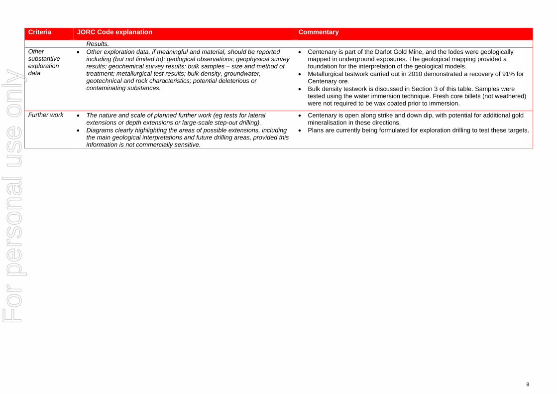
• Other exploration data, if meaningful and material, should be reported including (but not limited to): geological observations; geophysical survey results; geochemical survey results; bulk samples – size and method of treatment; metallurgical test results; bulk density, groundwater, geotechnical and rock characteristics; potential deleterious or contaminating substances.
• Centenary is part of the Darlot Gold Mine, and the lodes were geologically mapped in underground exposures. The geological mapping provided a foundation for the interpretation of the geological models.
• Metallurgical testwork carried out in 2010 demonstrated a recovery of 91% for Centenary ore.
• Bulk density testwork is discussed in Section 3 of this table. Samples were tested using the water immersion technique. Fresh core billets (not weathered) were not required to be wax coated prior to immersion.
Further work • The nature and scale of planned further work (eg tests for lateral extensions or depth extensions or large-scale step-out drilling).
• Diagrams clearly highlighting the areas of possible extensions, including the main geological interpretations and future drilling areas, provided this information is not commercially sensitive.
• Centenary is open along strike and down dip, with potential for additional gold mineralisation in these directions.
• Plans are currently being formulated for exploration drilling to test these targets.
For
per
sona
l use
onl
y
9
Section 3 Estimation and Reporting of Mineral Resources (Criteria listed in section 1, and where relevant in section 2, also apply to this section.)
Criteria JORC Code explanation Commentary
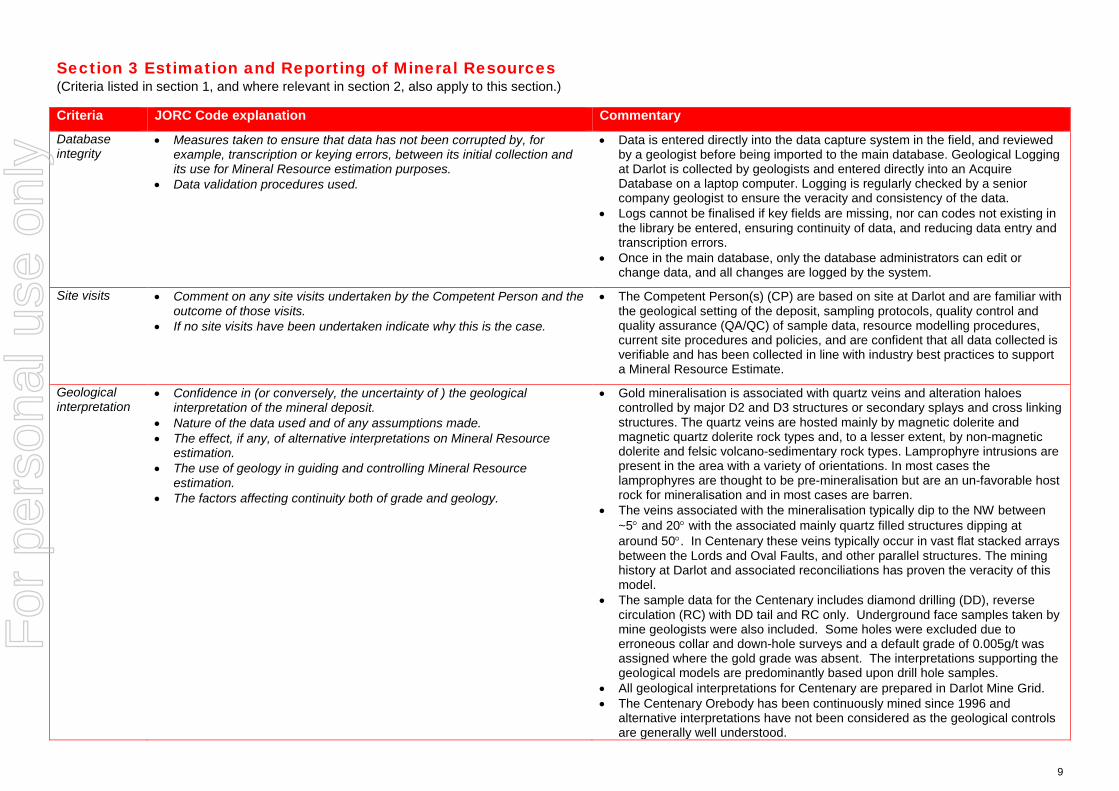
Database integrity
• Measures taken to ensure that data has not been corrupted by, for example, transcription or keying errors, between its initial collection and its use for Mineral Resource estimation purposes.
• Data validation procedures used.
• Data is entered directly into the data capture system in the field, and reviewed by a geologist before being imported to the main database. Geological Logging at Darlot is collected by geologists and entered directly into an Acquire Database on a laptop computer. Logging is regularly checked by a senior company geologist to ensure the veracity and consistency of the data.
• Logs cannot be finalised if key fields are missing, nor can codes not existing in the library be entered, ensuring continuity of data, and reducing data entry and transcription errors.
• Once in the main database, only the database administrators can edit or change data, and all changes are logged by the system.
Site visits • Comment on any site visits undertaken by the Competent Person and the outcome of those visits.
• If no site visits have been undertaken indicate why this is the case.
• The Competent Person(s) (CP) are based on site at Darlot and are familiar with the geological setting of the deposit, sampling protocols, quality control and quality assurance (QA/QC) of sample data, resource modelling procedures, current site procedures and policies, and are confident that all data collected is verifiable and has been collected in line with industry best practices to support a Mineral Resource Estimate.
Geological interpretation
• Confidence in (or conversely, the uncertainty of ) the geological interpretation of the mineral deposit.
• Nature of the data used and of any assumptions made. • The effect, if any, of alternative interpretations on Mineral Resource
estimation. • The use of geology in guiding and controlling Mineral Resource
estimation. • The factors affecting continuity both of grade and geology.
• Gold mineralisation is associated with quartz veins and alteration haloes controlled by major D2 and D3 structures or secondary splays and cross linking structures. The quartz veins are hosted mainly by magnetic dolerite and magnetic quartz dolerite rock types and, to a lesser extent, by non-magnetic dolerite and felsic volcano-sedimentary rock types. Lamprophyre intrusions are present in the area with a variety of orientations. In most cases the lamprophyres are thought to be pre-mineralisation but are an un-favorable host rock for mineralisation and in most cases are barren.
• The veins associated with the mineralisation typically dip to the NW between ~5° and 20° with the associated mainly quartz filled structures dipping at around 50°. In Centenary these veins typically occur in vast flat stacked arrays between the Lords and Oval Faults, and other parallel structures. The mining history at Darlot and associated reconciliations has proven the veracity of this model.
• The sample data for the Centenary includes diamond drilling (DD), reverse circulation (RC) with DD tail and RC only. Underground face samples taken by mine geologists were also included. Some holes were excluded due to erroneous collar and down-hole surveys and a default grade of 0.005g/t was assigned where the gold grade was absent. The interpretations supporting the geological models are predominantly based upon drill hole samples.
• All geological interpretations for Centenary are prepared in Darlot Mine Grid. • The Centenary Orebody has been continuously mined since 1996 and
alternative interpretations have not been considered as the geological controls are generally well understood.
For
per
sona
l use
onl
y

10
Criteria JORC Code explanation Commentary
• The Centenary Deposit is sub-divided into eighteen mineralised domains based on geology and structure, with the steeper fault hosted domains such as Walters, Lords and Oval areas separated from the flatter wing vein hosted mineralisation such as the Grace-Marsh bulk and Boon North areas. There are also shallowly dipping domains such as the Benaud’s Link. Those domains with similar characteristics were grouped geo-statistically.
• The site geologists prepared the interpretations of the mineralised lodes within these domains and the 254 lodes are modeled as 304 individual wireframes.
• The grade in the ore bodies is controlled by both structure and host lithology, in that typically the best grades are hosted by the Magnetic Dolerite and Felsic intrusions, with comparatively lesser grades observed in the other host rocks such as the non-magnetic dolerite. Consequently host lithology for lodes was a key factor considered for the estimate.
Dimensions • The extent and variability of the Mineral Resource expressed as length (along strike or otherwise), plan width, and depth below surface to the upper and lower limits of the Mineral Resource.
• The deposit has an overall strike length of about 1.3km and a width of about 0.5km and extends from about 150m to 700m below the natural surface.
Estimation and modelling techniques
• The nature and appropriateness of the estimation technique(s) applied and key assumptions, including treatment of extreme grade values, domaining, interpolation parameters and maximum distance of extrapolation from data points. If a computer assisted estimation method was chosen include a description of computer software and parameters used.
• The availability of check estimates, previous estimates and/or mine production records and whether the Mineral Resource estimate takes appropriate account of such data.
• The assumptions made regarding recovery of by-products. • Estimation of deleterious elements or other non-grade variables of
economic significance (eg sulphur for acid mine drainage characterisation).
• In the case of block model interpolation, the block size in relation to the average sample spacing and the search employed.
• Any assumptions behind modelling of selective mining units. • Any assumptions about correlation between variables. • Description of how the geological interpretation was used to control the
resource estimates. • Discussion of basis for using or not using grade cutting or capping. • The process of validation, the checking process used, the comparison of
model data to drill hole data, and use of reconciliation data if available.
• As previously noted, the Mineral Resource estimate has been divided into eighteen (18) domains for the purpose of resource estimation. The model was constructed with manual wireframing in both Vulcan and Datamine software.
• The 304 wireframes mentioned above were imported directly into Datamine for grade estimation and resource reporting.
• Datamine was used for block modelling, grade interpolation, and Mineral Resource classification and reporting. Snowden Supervisor was used for geostatistical analyses. The Au domain interpretations were based upon both geology and grade.
• Given the crenulated nature of some of the Centenary lodes, several of the domains were flattened, meaning all composites and blocks are transformed to a single RL and estimated in 2D space, and then re-transformed back into 3D space. Only the elevation is adjusted while the X and Y coordinates remain the same.
• The interpreted mineralisation wireframes encompass broad areas, with gold grades that vary from poorly mineralised through to significantly mineralised within each domain. To improve definition of higher grades within the mineralised domains an indicator estimation method, based on ≥ 1 g/t Au and ≥ 3 g/t Au composited drill hole grade thresholds, was applied. The two thresholds are selected to identify areas of lower grade gold mineralisation from the high grade gold mineralisation and the threshold of 3 g/t Au is intentionally below the Mineral Resource reporting cut-off and the Ore Reserves reporting cut-off.
• Significant amounts of lamprophyre which are generally barren cross-cut some of the lodes, some of the larger ones were wire-framed by the site geologists, while a categorical estimation technique was applied to model out the less continuous dykes, based on an indicator kriging technique. These areas are then flagged as waste in the final model.
For
per
sona
l use
onl
y
11
Criteria JORC Code explanation Commentary
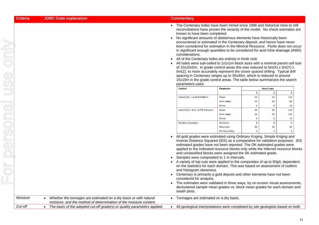
• The Centenary lodes have been mined since 1996 and historical mine to mill reconciliations have proven the veracity of the model. No check estimates are known to have been completed.
• No significant amounts of deleterious elements have historically been encountered or estimated in the Centenary deposit, and hence have never been considered for estimation in the Mineral Resource. Pyrite does not occur in significant enough quantities to be considered for acid mine drainage (AMD) considerations.
• All of the Centenary lodes are entirely in fresh rock • All lodes were sub-celled to 1x1x1m block sizes with a nominal parent cell size
of 10x10x5m. In grade control areas this was reduced to 5m(X) x 5m(Y) x 5m(Z), to more accurately represent the closer spaced drilling. Typical drill spacing in Centenary ranges up to 30x30m, which is reduced to around 15x15m in the grade control areas. The table below summarizes the search parameters used.
• All gold grades were estimated using Ordinary Kriging, Simple Kriging and
Inverse Distance Squared (IDS) as a comparative for validation purposes. IDS estimated grades have not been reported. The OK estimated grades were applied to the Indicated resource blocks only while the Inferred resource blocks and unclassified blocks were assigned the SK estimated grade.
• Samples were composited to 1 m intervals. • A variety of top cuts were applied to the composites of up to 60g/t; dependent
on the statistics for each domain. This was based on assessment of outliers and histogram skewness.
• Centenary is primarily a gold deposit and other elements have not been considered for analysis.
• The estimates were validated in three ways, by on-screen visual assessments, declustered sample mean grades vs. block mean grades for each domain and swath plots.
Moisture • Whether the tonnages are estimated on a dry basis or with natural moisture, and the method of determination of the moisture content.
• Tonnages are estimated on a dry basis.
Cut-off • The basis of the adopted cut-off grade(s) or quality parameters applied. • All geological interpretations were completed by site geologists based on both
For
per
sona
l use
onl
y

12
Criteria JORC Code explanation Commentary
parameters grade and lithology, and an approximate lower cut-off of around 0.5g/t.
Mining factors or assumptions
• Assumptions made regarding possible mining methods, minimum mining dimensions and internal (or, if applicable, external) mining dilution. It is always necessary as part of the process of determining reasonable prospects for eventual economic extraction to consider potential mining methods, but the assumptions made regarding mining methods and parameters when estimating Mineral Resources may not always be rigorous. Where this is the case, this should be reported with an explanation of the basis of the mining assumptions made.
• Domains were modelled to a minimum 1 m plan width.
Metallurgical factors or assumptions
• The basis for assumptions or predictions regarding metallurgical amenability. It is always necessary as part of the process of determining reasonable prospects for eventual economic extraction to consider potential metallurgical methods, but the assumptions regarding metallurgical treatment processes and parameters made when reporting Mineral Resources may not always be rigorous. Where this is the case, this should be reported with an explanation of the basis of the metallurgical assumptions made.
• During the mining history of the Centenary lodes the mill at Darlot has generally achieved >93-95% recoveries with a significant portion of the gold also captured by a gravity circuit.
• The CP is not aware of any specific metallurgical test-work for these orebodies.
Environmen-tal factors or assumptions
• Assumptions made regarding possible waste and process residue disposal options. It is always necessary as part of the process of determining reasonable prospects for eventual economic extraction to consider the potential environmental impacts of the mining and processing operation. While at this stage the determination of potential environmental impacts, particularly for a greenfields project, may not always be well advanced, the status of early consideration of these potential environmental impacts should be reported. Where these aspects have not been considered this should be reported with an explanation of the environmental assumptions made.
• Darlot has had an extensive mining history and as such has full infrastructure for the treatment of processing and mining residues.
• Darlot is certified as ISO14001 compliant for environmental management and is also certified for International Cyanide Management Code.
Bulk density • Whether assumed or determined. If assumed, the basis for the assumptions. If determined, the method used, whether wet or dry, the frequency of the measurements, the nature, size and representativeness of the samples.
• The bulk density for bulk material must have been measured by methods that adequately account for void spaces (vugs, porosity, etc), moisture and differences between rock and alteration zones within the deposit.
• Discuss assumptions for bulk density estimates used in the evaluation process of the different materials.
• A dry (in situ) bulk density of 2.90 t/m3 has been used for all lithologies. This value has been historically assigned for the Darlot project area.
• Data is available for bulk density determinations and is recorded in Red 5 Limited’s database, and was assessed by previous operators of the Darlot Gold Mine. The CP is satisfied that the value used is verifiable and typical given their knowledge and experience in similar deposits in the Eastern Goldfields of Western Australia.
• All the bulk density records that have been sighted were determined by the Archimedes method of immersion in water, with no wax coating required as porosity is not an issue in Darlot host rocks. These samples are considered representative of the lodes and waste zones.
Classification • The basis for the classification of the Mineral Resources into varying confidence categories.
• Whether appropriate account has been taken of all relevant factors (ie relative confidence in tonnage/grade estimations, reliability of input data, confidence in continuity of geology and metal values, quality, quantity and distribution of the data).
• The Mineral Resource is classified as Indicated and Inferred. • The geological evidence for mineralisation occurrence and continuity was
observed in drill samples and significant underground workings on the Centenary lodes. For classification of Indicated; in the main steep lodes a drill spacing of <40 x 40 m was required, with <20 x 20 m for the flatter lodes. For classification of Inferred; < 60 x 60 m for steep lodes and < 40 x 40 m for the
For
per
sona
l use
onl
y

13
Criteria JORC Code explanation Commentary
• Whether the result appropriately reflects the Competent Person’s view of the deposit.
flatter lodes. Any blocks outside these parameters were unclassified. Drill sampling and analytical techniques for DD and RC drilling as well as face sampling are well documented by Red 5 Limited, as well as rigorous QAQC protocols and documentation to support an Indicated Resource Classification where geological confidence allows.
• The classification of the Mineral Resource took into account the geological understanding of the deposit, quality of the samples, quality and quantity of density data, drill hole spacing, and the quality of the block grade estimates. Geological understanding and quality of samples is sufficient to assume geological and grade continuity in the Indicated volumes.
• All relevant factors have been taken into account when determining the resource classification for Centenary deposit, and the results are deemed by the CP to be fair and relevant.
Audits or reviews
• The results of any audits or reviews of Mineral Resource estimates. • The Mineral Resource Estimate was peer reviewed internally by Goldfields Australia, and also by OPTIRO consultants.
Discussion of relative accuracy/ confidence
• Where appropriate a statement of the relative accuracy and confidence level in the Mineral Resource estimate using an approach or procedure deemed appropriate by the Competent Person. For example, the application of statistical or geostatistical procedures to quantify the relative accuracy of the resource within stated confidence limits, or, if such an approach is not deemed appropriate, a qualitative discussion of the factors that could affect the relative accuracy and confidence of the estimate.
• The statement should specify whether it relates to global or local estimates, and, if local, state the relevant tonnages, which should be relevant to technical and economic evaluation. Documentation should include assumptions made and the procedures used.
• These statements of relative accuracy and confidence of the estimate should be compared with production data, where available.
• The Mineral Resource estimate is considered a global resource for both Indicated and Inferred Resource estimations.
• The CP is comfortable that more than 20 years of mining and reconciliation data is deemed sufficient to verify the veracity of the estimate.
• Fully surveyed voids have been used to deplete the model of already mined material.
For
per
sona
l use
onl
y

14
JORC Code, 2012 Edition – Table 1 for the Pederson Resource – Part of the Darlot Deposit
Section 1 Sampling Techniques and Data (Criteria in this section apply to all succeeding sections.)
Criteria JORC Code explanation Commentary
Sampling techniques
• Nature and quality of sampling (eg cut channels, random chips, or specific specialised industry standard measurement tools appropriate to the minerals under investigation, such as down hole gamma sondes, or handheld XRF instruments, etc). These examples should not be taken as limiting the broad meaning of sampling.
• Include reference to measures taken to ensure sample representivity and the appropriate calibration of any measurement tools or systems used.
• Aspects of the determination of mineralisation that are Material to the Public Report.
• In cases where ‘industry standard’ work has been done this would be relatively simple (eg ‘reverse circulation drilling was used to obtain 1 m samples from which 3 kg was pulverised to produce a 30 g charge for fire assay’). In other cases more explanation may be required, such as where there is coarse gold that has inherent sampling problems. Unusual commodities or mineralisation types (eg submarine nodules) may warrant disclosure of detailed information.
• Reverse circulation (RC) and diamond core (DD) drilling provided pulverized chips and (generally) competent lengths of core samples. A small quantity of face sampling is included in the database. Drill hole data supporting the Mineral Resource contains 2,900 holes for a total sample length of 258,186.1 m.
• A total of 868 Diamond drill holes (73,000.58 m), 418 RCDD holes (RC collars with DD tails, 115,221.27 m), 699 RC holes (64,501.55 m) and 915 face samples (5,462.7 m) support the Mineral Resource.
• RC samples of 1 m drill length were passed through a rig mounted cyclone and collected in large plastic bags positioned beneath the cyclone. The action of the cyclone adequately homogenizes the sample collected in the bag. Representative 3 kg samples were collected in calico bags for dispatch to the analytical laboratory.
• Diamond core is predominantly NQ2 with some HQ was cleaned, laid out, measured and logged in its entirety. Core is marked up with a maximum core length of 1 m, depending on core size. Some core is whole sampled (full core collection) when necessary, but most core is half cut core. Digital photographs are taken and stored for reference purposes. Where possible core is cut in half with one half only being submitted for analysis at the Laboratory, with the other half is stored in the core farm for reference.
• Underground face sampling was carried out by the mine geologist painting a sample line orthogonal to the dip of the quartz veining and sampled according to geological intervals. Samples were bagged and ticketed with unique sample IDs and dispatched to the assay laboratory.
Drilling techniques
• Drill type (eg core, reverse circulation, open-hole hammer, rotary air blast, auger, Bangka, sonic, etc) and details (eg core diameter, triple or standard tube, depth of diamond tails, face-sampling bit or other type, whether core is oriented and if so, by what method, etc).
• The sample data for the Pedersen area includes diamond drilling (DD), reverse circulation holes with diamond core tails (RCDD), reverse circulation only drill holes (RC), surface drill holes (SURF) and underground face samples (FACE). The data was collected during 1998 to 1999 and 2007 to 2015.
• Surface DDH is generally NQ2 or HQ, while underground DDH is usually NQ2 or LTK60. Underground exploration/resource drilling is almost exclusively DD.
• RC drilling used a face sampling hammer.
Drill sample recovery
• Method of recording and assessing core and chip sample recoveries and results assessed.
• Measures taken to maximise sample recovery and ensure representative nature of the samples.
• Whether a relationship exists between sample recovery and grade and whether sample bias may have occurred due to preferential loss/gain of fine/coarse material.
• Drill sample recoveries are recorded for each sample number and stored in the Acquire database. Diamond core samples were geotechnically logged and sample recoveries calculated. Most drill samples penetrating mineralisation are diamond core with RC closer to the topographic surface, and weights of RC samples are not recorded. Visual checks by the supervising geologist assessed RC sample recovery on the run.
• Diamond drilling and open pit grade control drilling typically provide close to
For
per
sona
l use
onl
y
15
Criteria JORC Code explanation Commentary
100% sample recovery, and where core loss occurs, it is recorded. Pre-1995 drilling did not utilise core blocks making estimation of core recovery prior to that point in time difficult.
• Core recovery factors for core drilling are generally very high typically in excess of 95% recovery. Some loss occurs locally when drilling through fault/shear zones.
• Where possible, RC percussion samples are recovered from the RC drill rig through the cyclone splitter, providing a 2-4 kg sample, which is submitted for assay.
• Periodic reviews of early drilling assay results and bias may be done form time to time where required on historical prospects where new drilling is done. Q-Q Plots of the re-drills and original holes are correlated and any bias (positive / negative) identified. This is utilised in any future interpretations and modelling.
• The supervising geologist monitored the diamond core recoveries and discussed any shortcoming with the driller.
Logging • Whether core and chip samples have been geologically and geotechnically logged to a level of detail to support appropriate Mineral Resource estimation, mining studies and metallurgical studies.
• Whether logging is qualitative or quantitative in nature. Core (or costean, channel, etc) photography.
• The total length and percentage of the relevant intersections logged.
• A geologist was present at all times during drilling and sampling. Geological logging protocols at the time of drilling were followed to ensure consistency in drill logs between the geological staff.
• RC chips were logged for weathering, lithologies, mineralogy, colour and grainsize. RC chip trays (with chips) were infrequently photographed.
• Diamond core were logged for lithology, structure, stratigraphy, mineralisation, alteration, geophysical (magnetic properties) and geochemical properties (multi-element assays) and physical measurements (rock hardness, geotechnical RQD's, density, acid rock drainage (ARD)).
• The full sample lengths were logged. Core was photographed (mostly wet).
Sub-sampling techniques and sample preparation
• If core, whether cut or sawn and whether quarter, half or all core taken. • If non-core, whether riffled, tube sampled, rotary split, etc and whether
sampled wet or dry. • For all sample types, the nature, quality and appropriateness of the
sample preparation technique. • Quality control procedures adopted for all sub-sampling stages to
maximise representivity of samples. • Measures taken to ensure that the sampling is representative of the in
situ material collected, including for instance results for field duplicate/second-half sampling.
• Whether sample sizes are appropriate to the grain size of the material being sampled.
• DDH core sample lengths can be variable in a mineralized zone, though usually no larger than one-metre. This enables the capture of assay data for narrow structures and localized grade variations.
• Grade control drill holes are sampled as whole core. DDH samples are taken according to a cut sheet compiled by the geologist. Half or full core samples are bagged in pre-numbered calico bags and submitted with a sample submission form.
• DDH core is cut by a Geotech field assistant. • RC drilling is logged and sampled on one-metre intervals using similar codes to
DDH core. • The sampling protocols for both DD and RC are considered appropriate for the
style of mineralisation. • A summary of the sample preparation process is as below:
o Oven dried at 105ºC. o Jaw crushed to -12 mm. o If sample >3kg, Boyd crusher to 3 mm, and riffle split to <3kg. o Pulverised in LM5. o 250-300 g pulp sample taken.
For
per
sona
l use
onl
y
16
Criteria JORC Code explanation Commentary
o Remainder of pulp returned to calico sample bag. • Quality Control (QC) samples are inserted at a rate of 1 in 20. All standards
used are Certified Reference Materials (CRM). The insertion of blanks is under the control of the geologist and CRMs are usually inserted one per batch.
• Sample sizes are considered appropriate to the grain size of the material being sampled.
Quality of assay data and laboratory tests
• The nature, quality and appropriateness of the assaying and laboratory procedures used and whether the technique is considered partial or total.
• For geophysical tools, spectrometers, handheld XRF instruments, etc, the parameters used in determining the analysis including instrument make and model, reading times, calibrations factors applied and their derivation, etc.
• Nature of quality control procedures adopted (eg standards, blanks, duplicates, external laboratory checks) and whether acceptable levels of accuracy (ie lack of bias) and precision have been established.
• Primary assaying of face samples, DDH and RC has been undertaken by ALS Kalgoorlie for considerable time. Documentation regarding more historical holes and their sample analyses are not well documented. Analysis is by 50g fire assay (FA) with Atomic Absorption Spectrometer (AAS) finish to 0.01 g/t detection limit. Given the occurrence of coarse gold, Screen Fire Assays (SFA) checks are periodically.
• The processes are considered total. • Previous operators employed a comprehensive QA/QC regime with CRMs,
blanks, quartz flush checks and grind checks routinely monitored. Coarse duplicates from crush residue, and pulp duplicates from pulp residues were regularly monitored to test the quality of sub sampling stages. Results are documented on a quarterly basis, with any failures or irregularities investigated and actions taken to correct the issue. Regular communications were had with ALS.
• Acceptable levels of accuracy and precision were established prior to accepting the sample data as support for the Mineral Resource estimate.
• The QAQC procedures and results show acceptable levels of accuracy and precision were established.
Verification of sampling and assaying
• The verification of significant intersections by either independent or alternative company personnel.
• The use of twinned holes. • Documentation of primary data, data entry procedures, data verification,
data storage (physical and electronic) protocols. • Discuss any adjustment to assay data.
• Pedersen is a mature deposit within Darlot mining operations, and intersections with significant Au grade are not unknown. Visible Au is often observed. If core samples with significant intersections are logged then alternative geological personnel are likely to review and confirm the results.
• No twin drilling has occurred at Pedersen. • All data at Darlot is stored in an SQL relational database format using acQuire
software. acQuire enables definition of tasks, permission management and database integrity. The SQL Server database is configured for optimal validation through constraints, library tables and triggers. Data that fails these rules on import is rejected and not ranked as a priority to be used for exports or any data applications.
• All exploration data control is managed centrally, from drill-hole planning to final assay, survey and geological capture. The majority of logging data (lithology, alteration, and structural characteristics of core and percussion chips) is captured directly either by manual or to customised digital logging tools with stringent validation and data entry constraints. Geologists load data in the acquire database where initial validation of the data occurs. The data are uploaded into the database by the geologist after which ranking of the data happen based on multiple QAQC and validation rules.
• All assay data is uploaded into the database in a text format known as a sif.
For
per
sona
l use
onl
y
17
Criteria JORC Code explanation Commentary
These files include detailed information about the batch, methods, units, detection limits and elements assayed. The file also includes all QC data in the sequence of analysis. The assay data is stored in a flattened format to ensure all required information is stored for each sample, and that multiple assay results are stored for each sample.
• Data validation is controlled via rules, library tables and triggers. Once all data for a drill-hole have been entered into the database, the geologist responsible for the drilling program validates each drill-hole. A standard validation trigger in the acquire database run queries against the data, which includes checks for; incorrect collar locations, testing for overlapping, missing or incorrect down-hole surveys, and incorrect collar location.
• A digital certified assay certificate in Adobe PDF format is backed up on the Darlot server on a regular schedule. A copy of the database also resides on the Red 5 back-up server in Perth.
• The database is secure and password protected by the Database Administrator to prevent accidental or malicious adjustment to data.
• No adjustments are made to the data.
Location of data points
• Accuracy and quality of surveys used to locate drill holes (collar and down-hole surveys), trenches, mine workings and other locations used in Mineral Resource estimation.
• Specification of the grid system used. • Quality and adequacy of topographic control.
• Collars are marked out pre and post drilling by licensed surveyors. Surface collars were surveyed using Differential Global Positioning System (DGPS). All recent DDH holes were surveyed down the hole by single shot down hole camera and Reflex non-magnetic multi shot gyro survey. Down hole surveys are routinely undertaken by the drilling contractor. Due to the relatively short depths of RC drilling (<100m) these holes are generally not surveyed. When RC is used as pre-collars to DDH tails, these are then surveyed using standard down hole gyro.
• Drill hole collars are located respective to the local mine grid and to the overall property in UTM MGA94-Zone51. Mine grid north is 44° west of north Australian Map Grid, and all mining Mineral Resource and Ore Reserve work is carried out in Mine Grid. Reduced Level (RL) for surface drilling is calculated by adding 1,000 m to surface elevation, while the underground RL is calculated by taking the surface RL minus the vertical depth to the point being referenced.
• The Pedersen Mineral Resource daylights into the open pit void and the open pit was surveyed at end of mining by licensed mine surveyors. The natural topographic surface is very flat with minor undulations. Underground voids are surveyed by mine surveyors. The control on these topographies and voids is considered adequate.
Data spacing and distribution
• Data spacing for reporting of Exploration Results. • Whether the data spacing and distribution is sufficient to establish the
degree of geological and grade continuity appropriate for the Mineral Resource and Ore Reserve estimation procedure(s) and classifications applied.
• Whether sample compositing has been applied.
• Drill hole spacing at Pedersen ranges from 20 m(gN) by 20 m (gE) to 40 m(gN) by 40 m (gE)
• The Competent Person considers the data spacing to be sufficient to establish the degree of geological and grade continuity appropriate for the Mineral Resource classification categories adopted for Pedersen.
• Samples were not composited prior to dispatch for analyses.
Orientation of • Whether the orientation of sampling achieves unbiased sampling of • Pedersen was drilled by a combination of surface and underground holes. The
For
per
sona
l use
onl
y
18
Criteria JORC Code explanation Commentary
data in relation to geological structure
possible structures and the extent to which this is known, considering the deposit type.
• If the relationship between the drilling orientation and the orientation of key mineralised structures is considered to have introduced a sampling bias, this should be assessed and reported if material.
surface holes were orientated to penetrate the host unit as orthogonally as possible, however underground drilling is confined to drill cuddies and the orientation of exploration holes is often oblique to the mineralisation.
• Resultant sampling bias is usually retained in the drill database and any potential impact upon the Mineral Resource was not assessed. The Competent Person does not believe any potential impacts to be material in terms of grade interpolation.
Sample security
• The measures taken to ensure sample security. • Although security in not strongly enforced, Darlot is a remote site and the number of outside visitors is small. The deposit is known to contain visible gold and this renders the core susceptible to theft, however the risk of sample tampering is considered low.
• ALS Kalgoorlie organise transport companies to pick up bagged samples from a secured locality at the mine site. These are then transported to the laboratory facility for further preparation and assaying. All samples received by the laboratory are physically checked against the despatch order and Darlot is notified of any discrepancies prior to sample preparation commencing. No Red 5 personnel are involved in the preparation or analysis process.
Audits or reviews
• The results of any audits or reviews of sampling techniques and data. • A series of written standard procedures exists for sampling and core cutting at Darlot. Periodic routine visits to drill rigs and the core farm are carried out by project geologists and Senior Geologists / Superintendents to review core logging and sampling practices.
For
per
sona
l use
onl
y
19
Section 2 Reporting of Exploration Results (Criteria listed in the preceding section also apply to this section.)
Criteria JORC Code explanation Commentary
Mineral tenement and land tenure status
• Type, reference name/number, location and ownership including agreements or material issues with third parties such as joint ventures, partnerships, overriding royalties, native title interests, historical sites, wilderness or national park and environmental settings.
• The security of the tenure held at the time of reporting along with any known impediments to obtaining a licence to operate in the area.
• Pedersen is covered by mining lease M37/155 and held by Darlot Mining Company Limited. This lease covers 1,000Ha and was granted on 18/7/1988, renewed 17/7/2009 and to be renewed on 17/7/2030. Current rental has been paid ($17,600) and minimum annual expenditure of $100,000 is required, and is being met. There are no Joint Ventures over the tenure and no native title claims. There are no other agreements in place apart from a 2.5% royalty for all gold sold, payable to the Government of Western Australia.
Exploration done by other parties
• Acknowledgment and appraisal of exploration by other parties. • Pedersen is part of the Darlot Gold Mine, which has a long history of gold mining and exploration. Alluvial gold was first mined in the area in 1894 with a consequent gold rush between 1895 and 1913. Total gold production from this time is unknown. Limited gold production occurred between 1935 and 1980.
• Modern exploration of Darlot commenced in the period in the 1970’s, with intensive exploration by Sundowner Minerals NL during 1986 to 1988. Darlot open pit mining commenced in 1988, and Sundowner was acquired by Plutonic Resources in 1992, who continued open cut mining through to 1995. Underground mining commenced in 1995 and has continued to the present day. To the end of October 2017, the Darlot Gold Mine has produced 17 Mt @ 4.8 g/t Au for 2.7 Moz.
• A total of 868 Diamond drill holes (73,000.58 m), 418 RCDD holes (RC collars with DD tails, 115,221.27 m), 699 RC holes (64,501.55 m) and 915 face samples (5,462.7 m) support the Mineral Resource, drilled since modern exploration commenced in 1988.
• Pedersen was mined from 1988 to 1995 from an Open pit and has continued to be mined sporadically from 1995 to the present day from the Darlot Underground workings,
Geology • Deposit type, geological setting and style of mineralisation. • The Darlot lodes are considered to be part of an Archean hydrothermal fault-vein deposit with many similar characteristics with other deposits within the Yilgarn Craton, namely host rock type and nature of hydrothermal alteration; however, it is atypical in being relatively flat-lying rather than steeply dipping. Felsic porphyries and lamprophyre intrusions are encountered throughout the deposit. The major host for gold mineralisation is the Mount Pickering Dolerite.
• In the Pedersen area the mineralisation crosses lithological boundaries and is present in the magnetic dolerite (MMD), within the adjacent areas of mixed dolerite and felsic porphyry (MD and FAP) and within the porphyritic dolerite. Non-mineralised and variably mineralised lamprophyres including the main regional lamprophyre and smaller lamprophyres subparallel to the Pedersen mineralisation or the regional trend.
• The Darlot gold mineralisation is located about the Darlot Thrust and is associated with quartz veins and alteration haloes controlled by major D2 and D3 structures, secondary splays and cross-linking structures.
For
per
sona
l use
onl
y
20
Criteria JORC Code explanation Commentary
Drill hole Information
• A summary of all information material to the understanding of the exploration results including a tabulation of the following information for all Material drill holes: o easting and northing of the drill hole collar o elevation or RL (Reduced Level – elevation above sea level in metres)
of the drill hole collar o dip and azimuth of the hole o down hole length and interception depth o hole length.
• If the exclusion of this information is justified on the basis that the information is not Material and this exclusion does not detract from the understanding of the report, the Competent Person should clearly explain why this is the case.
• Drill hole information from Darlot drill programs were used to support the Mineral Resource estimate. The locations of drill samples, and the geological logs of these samples were used to build the geological model, and with the sample analyses, support the Mineral Resource estimate.
Data aggregation methods
• In reporting Exploration Results, weighting averaging techniques, maximum and/or minimum grade truncations (eg cutting of high grades) and cut-off grades are usually Material and should be stated.
• Where aggregate intercepts incorporate short lengths of high grade results and longer lengths of low grade results, the procedure used for such aggregation should be stated and some typical examples of such aggregations should be shown in detail.
• The assumptions used for any reporting of metal equivalent values should be clearly stated.
• Exploration results are not reported here, with all drill holes used to support the Mineral Resource estimate. Sludge samples are recorded in the drill hole database but were not used in the Mineral Resource estimate due insufficient reliability of sampling methods.
Relationship between mineralisation widths and intercept lengths
• These relationships are particularly important in the reporting of Exploration Results.
• If the geometry of the mineralisation with respect to the drill hole angle is known, its nature should be reported.
• If it is not known and only the down hole lengths are reported, there should be a clear statement to this effect (eg ‘down hole length, true width not known’).
• From mapping and diamond drilling, mineralisation appear to be dipping approximately 20 degrees. Drillholes are angled to drill as close to perpendicular to mineralisation as possible, although this is difficult when drilling from underground locations, targeting lode positions along strike from the drill cuddy.
• Intercepts reported are downhole length, and true width can generally be calculated because the dip of the lode is known.
Diagrams • Appropriate maps and sections (with scales) and tabulations of intercepts should be included for any significant discovery being reported These should include, but not be limited to a plan view of drill hole collar locations and appropriate sectional views.
• Isometric view representing the Darlot deposit (including the Pederson Resource) is shown in announcement.
Balanced reporting
• Where comprehensive reporting of all Exploration Results is not practicable, representative reporting of both low and high grades and/or widths should be practiced to avoid misleading reporting of Exploration Results.
• Exploration results are not reported here, with all drill holes used to support the Mineral Resource estimate.
Other substantive exploration data
• Other exploration data, if meaningful and material, should be reported including (but not limited to): geological observations; geophysical survey results; geochemical survey results; bulk samples – size and method of treatment; metallurgical test results; bulk density, groundwater, geotechnical and rock characteristics; potential deleterious or contaminating substances.
• Pedersen is part of the Darlot Gold Mine, and the lodes were geologically mapped at both open cut and underground exposures. The geological mapping provided a foundation for the interpretation of the geological models.
• Metallurgical testwork carried out in 2010 demonstrates a recovery of 94% achievable from Pedersen ore samples.
• Bulk density testwork is discussed in Section 3 of this table.
For
per
sona
l use
onl
y
21
Criteria JORC Code explanation Commentary
Further work • The nature and scale of planned further work (eg tests for lateral extensions or depth extensions or large-scale step-out drilling).
• Diagrams clearly highlighting the areas of possible extensions, including the main geological interpretations and future drilling areas, provided this information is not commercially sensitive.
• Down dip extremities of the Mineral Resource have not been mined due to the thinner widths of the lodes, but may be included in future Ore Reserve inventories.
• The Pedersen lodes die out once they reach the El Dorado Fault, and there is believed to be limited potential down dip for further mineralisation. There is potential for strike extension although this has not been tested, and there are no current plans for this evaluation.
For
per
sona
l use
onl
y
22
Section 3 Estimation and Reporting of Mineral Resources (Criteria listed in section 1, and where relevant in section 2, also apply to this section.)
Criteria JORC Code explanation Commentary
Database integrity
• Measures taken to ensure that data has not been corrupted by, for example, transcription or keying errors, between its initial collection and its use for Mineral Resource estimation purposes.
• Data validation procedures used.
• Data is entered directly into the data capture system in the field, and reviewed by a geologist before being imported to the main database. Geological Logging at Darlot is collected by geologists and entered directly into an Acquire Database on a laptop computer. Logging is regularly checked by a senior company geologist to ensure the veracity and consistency of the data.
• Logs cannot be finalised if key fields are missing, nor can codes not existing in the library be entered, ensuring continuity of data, and reducing data entry and transcription errors.
• Once in the main database, only the database administrators can edit or change data, and all changes are logged by the system.
Site visits • Comment on any site visits undertaken by the Competent Person and the outcome of those visits.
• If no site visits have been undertaken indicate why this is the case.
• The Competent Person(s) (CP) are based on site at Darlot and are familiar with the geological setting of the deposit, sampling protocols, quality control and quality assurance (QA/QC) of sample data, resource modelling procedures, current site procedures and policies, and are confident that all data collected is verifiable and has been collected in line with industry best practices to support a Mineral Resource Estimate.
Geological interpretation
• Confidence in (or conversely, the uncertainty of ) the geological interpretation of the mineral deposit.
• Nature of the data used and of any assumptions made. • The effect, if any, of alternative interpretations on Mineral Resource
estimation. • The use of geology in guiding and controlling Mineral Resource
estimation. • The factors affecting continuity both of grade and geology.
• The Darlot Gold mineralisation is associated mainly with the Darlot Thrust and associated quartz veins and alteration haloes controlled by major D2 and D3 structures or secondary splays and cross linking structures. The Darlot mineralisation is hosted by magnetic dolerite and magnetic quartz (porphyritic) dolerite rock types and, to a lesser extent, by non-magnetic dolerite and felsic volcano-sedimentary rock types. Lamprophyre intrusions are present in the area with a variety of orientations. In most cases the lamprophyres are thought to be pre-mineralisation but are an un-favorable host rock for mineralisation and in most cases are barren.
• The Darlot Thrust and associated major quartz bearing structures typically dip at around 20° to the SE, with associated hanging-wall veins that dip between 0° and 20° to NW. The mining history at Darlot and associated reconciliations has proven the veracity of this model.
• The sample data for the Pedersen includes diamond drilling (DD), reverse circulation (RC) with DD tail and RC only. Underground face samples taken by mine geologists were also included. Some holes were excluded due to erroneous collar and down-hole surveys and a default grade of 0.005g/t was assigned where the gold grade was absent. The interpretations supporting the geological models are predominantly based upon drill hole samples and also the mapping done by competent mining geologists in the Darlot pit and underground workings.
• All geological interpretations for Pedersen are prepared in Darlot Mine Grid. • The Pedersen deposit has been continuously mined since 1988 and alternative
interpretations have not been considered as the geological controls are
For
per
sona
l use
onl
y
23
Criteria JORC Code explanation Commentary
generally well understood. • The Pedersen Deposit is sub-divided into seventeen mineralised domains
based on geology and structure, with the moderately dipping fault hosted domains such as the Darlot thrust and Hurst areas separated from the flatter wing vein hosted mineralisation, such as the Pedersen hanging-wall lodes. Those domains with similar characteristics were grouped geo-statistically.
• The site geologists prepared the interpretations of the mineralised lodes within these seventeen domains; with 75 individual lode wireframes produced.
• The grade in the Pedersen deposit is controlled by both structure and host lithology, in that typically the best grades are hosted by the Magnetic Dolerite and Felsic intrusions, with comparatively lesser grades observed in the other host rocks such as the non-magnetic dolerite. Consequently host lithology for lodes was a key factor considered for the estimate.
Dimensions • The extent and variability of the Mineral Resource expressed as length (along strike or otherwise), plan width, and depth below surface to the upper and lower limits of the Mineral Resource.
• The deposit has an overall strike length of about 1,500m and a width of about 850 m and extends from just below the natural surface to a depth of about 450 m.
Estimation and modelling techniques
• The nature and appropriateness of the estimation technique(s) applied and key assumptions, including treatment of extreme grade values, domaining, interpolation parameters and maximum distance of extrapolation from data points. If a computer assisted estimation method was chosen include a description of computer software and parameters used.
• The availability of check estimates, previous estimates and/or mine production records and whether the Mineral Resource estimate takes appropriate account of such data.
• The assumptions made regarding recovery of by-products. • Estimation of deleterious elements or other non-grade variables of
economic significance (eg sulphur for acid mine drainage characterisation).
• In the case of block model interpolation, the block size in relation to the average sample spacing and the search employed.
• Any assumptions behind modelling of selective mining units. • Any assumptions about correlation between variables. • Description of how the geological interpretation was used to control the
resource estimates. • Discussion of basis for using or not using grade cutting or capping. • The process of validation, the checking process used, the comparison of
model data to drill hole data, and use of reconciliation data if available.
• As previously noted, the Mineral Resource estimate has been divided into seventeen (17) domains for the purpose of resource estimation. The model was constructed with manual wireframing in both Vulcan and Datamine software.
• The 75 wireframes mentioned above were imported directly into Datamine for grade estimation and resource reporting.
• Datamine was used for block modelling, grade interpolation, and Mineral Resource classification and reporting. Snowden Supervisor was used for geostatistical analyses. The Au domain interpretations were based upon both geology and grade.
• Given the crenulated nature of some of the Pedersen lodes, several of the domains were flattened, meaning all composites and blocks are transformed to a single RL and estimated in 2D space, and then re-transformed back into 3D space. Only the elevation is adjusted while the X and Y coordinates remain the same.
• The interpreted mineralisation wireframes encompass broad areas, with gold grades that vary from poorly mineralised through to significantly mineralised within each domain. To improve definition of higher grades within the mineralised domains an indicator estimation method, based on ≥ 1.12 g/t Au and ≥ 3.25 g/t Au composited drill hole grade thresholds, was applied. The two thresholds are selected to identify areas of lower grade gold mineralisation from the high grade gold mineralisation and the threshold of 3 g/t Au is intentionally below the Mineral Resource reporting cut-off and the Ore Reserves reporting cut-off.
• Significant amounts of lamprophyre which are generally barren cross-cut some of the lodes, some of the larger ones were wire-framed by the site geologists, while a categorical estimation technique was applied to model out the less continuous dykes, based on an indicator kriging technique. These areas are then flagged as waste in the final model.
For
per
sona
l use
onl
y
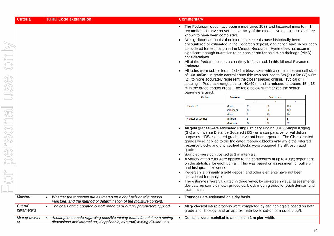
24
Criteria JORC Code explanation Commentary
• The Pedersen lodes have been mined since 1988 and historical mine to mill reconciliations have proven the veracity of the model. No check estimates are known to have been completed.
• No significant amounts of deleterious elements have historically been encountered or estimated in the Pedersen deposit, and hence have never been considered for estimation in the Mineral Resource. Pyrite does not occur in significant enough quantities to be considered for acid mine drainage (AMD) considerations.
• All of the Pedersen lodes are entirely in fresh rock in this Mineral Resource Estimate.
• All lodes were sub-celled to 1x1x1m block sizes with a nominal parent cell size of 10x10x5m. In grade control areas this was reduced to 5m (X) x 5m (Y) x 5m (Z), to more accurately represent the closer spaced drilling. Typical drill spacing in Pedersen ranges up to +40x40m, and is reduced to around 15 x 15 m in the grade control areas. The table below summarizes the search parameters used.
• All gold grades were estimated using Ordinary Kriging (OK), Simple Kriging
(SK) and Inverse Distance Squared (IDS) as a comparative for validation purposes. IDS estimated grades have not been reported. The OK estimated grades were applied to the Indicated resource blocks only while the Inferred resource blocks and unclassified blocks were assigned the SK estimated grade.
• Samples were composited to 1 m intervals. • A variety of top cuts were applied to the composites of up to 40g/t; dependent
on the statistics for each domain. This was based on assessment of outliers and histogram skewness.
• Pedersen is primarily a gold deposit and other elements have not been considered for analysis.
• The estimates were validated in three ways, by on-screen visual assessments, declustered sample mean grades vs. block mean grades for each domain and swath plots.
Moisture • Whether the tonnages are estimated on a dry basis or with natural moisture, and the method of determination of the moisture content.
• Tonnages are estimated on a dry basis
Cut-off parameters
• The basis of the adopted cut-off grade(s) or quality parameters applied. • All geological interpretations were completed by site geologists based on both grade and lithology, and an approximate lower cut-off of around 0.5g/t.
Mining factors or
• Assumptions made regarding possible mining methods, minimum mining dimensions and internal (or, if applicable, external) mining dilution. It is
• Domains were modelled to a minimum 1 m plan width.
For
per
sona
l use
onl
y

25
Criteria JORC Code explanation Commentary
assumptions always necessary as part of the process of determining reasonable prospects for eventual economic extraction to consider potential mining methods, but the assumptions made regarding mining methods and parameters when estimating Mineral Resources may not always be rigorous. Where this is the case, this should be reported with an explanation of the basis of the mining assumptions made.
Metallurgical factors or assumptions
• The basis for assumptions or predictions regarding metallurgical amenability. It is always necessary as part of the process of determining reasonable prospects for eventual economic extraction to consider potential metallurgical methods, but the assumptions regarding metallurgical treatment processes and parameters made when reporting Mineral Resources may not always be rigorous. Where this is the case, this should be reported with an explanation of the basis of the metallurgical assumptions made.
• During the mining history of the Pedersen lodes the mill at Darlot has generally achieved >93-95% recoveries with a significant portion of the gold also captured by a gravity circuit.
• The CP is not aware of any specific metallurgical test-work for these orebodies.
Environmen-tal factors or assumptions
• Assumptions made regarding possible waste and process residue disposal options. It is always necessary as part of the process of determining reasonable prospects for eventual economic extraction to consider the potential environmental impacts of the mining and processing operation. While at this stage the determination of potential environmental impacts, particularly for a greenfields project, may not always be well advanced, the status of early consideration of these potential environmental impacts should be reported. Where these aspects have not been considered this should be reported with an explanation of the environmental assumptions made.
• Darlot has had an extensive mining history and as such has full infrastructure for the treatment of processing and mining residues.
• Darlot is certified as ISO14001 compliant for environmental management and is also certified for International Cyanide Management Code.
Bulk density • Whether assumed or determined. If assumed, the basis for the assumptions. If determined, the method used, whether wet or dry, the frequency of the measurements, the nature, size and representativeness of the samples.
• The bulk density for bulk material must have been measured by methods that adequately account for void spaces (vugs, porosity, etc), moisture and differences between rock and alteration zones within the deposit.
• Discuss assumptions for bulk density estimates used in the evaluation process of the different materials.
• A dry (in situ) bulk density of 2.90 t/m3 has been used for all lithologies. This value has been historically assigned for the Darlot project area. The Pedersen Mineral Resource Estimate does not include any material above the top of fresh rock.
• Data is available for bulk density determinations and is recorded in Red 5 Limited’s database, and was assessed by previous operators of the Darlot Gold Mine. This CP is satisfied that the value used is verifiable and typical given their knowledge and experience in similar deposits in the Eastern Goldfields.
• All the bulk density records that have been sighted were determined by the Archimedes method of immersion in water, with no wax coating required as porosity is not an issue in Darlot host rocks. These samples are considered representative of the lodes and waste zones.
Classification • The basis for the classification of the Mineral Resources into varying confidence categories.
• Whether appropriate account has been taken of all relevant factors (ie relative confidence in tonnage/grade estimations, reliability of input data, confidence in continuity of geology and metal values, quality, quantity and distribution of the data).
• Whether the result appropriately reflects the Competent Person’s view of the deposit.
• The Mineral Resource is classified as Indicated and Inferred. • The geological evidence for mineralisation occurrence and continuity was
observed in drill samples and significant underground workings on the Pedersen lodes. For classification of Indicated a drill spacing of <40 x 40 m was required, for classification of Inferred; < 60 x 60 m was required. Any blocks outside these parameters were unclassified. Drill sampling and analytical techniques for DD and RC drilling as well as face sampling are well documented by Red 5 Limited, as well as rigorous QAQC protocols and documentation to support an Indicated Resource Classification where
For
per
sona
l use
onl
y

26
Criteria JORC Code explanation Commentary
geological confidence allows. • The classification of the Mineral Resource took into account the geological
understanding of the deposit, quality of the samples, quality and quantity of density data, drill hole spacing, and the quality of the block grade estimates. Geological understanding and quality of samples is sufficient to assume geological and grade continuity in the Indicated volumes.
• All relevant factors have been taken into account when determining the resource classification for Pedersen deposit, and the results are deemed by the CP to be fair and relevant.
Audits or reviews
• The results of any audits or reviews of Mineral Resource estimates. • The Mineral Resource Estimate was peer reviewed internally by Goldfields Australia, and also by OPTIRO consultants.
Discussion of relative accuracy/ confidence
• Where appropriate a statement of the relative accuracy and confidence level in the Mineral Resource estimate using an approach or procedure deemed appropriate by the Competent Person. For example, the application of statistical or geostatistical procedures to quantify the relative accuracy of the resource within stated confidence limits, or, if such an approach is not deemed appropriate, a qualitative discussion of the factors that could affect the relative accuracy and confidence of the estimate.
• The statement should specify whether it relates to global or local estimates, and, if local, state the relevant tonnages, which should be relevant to technical and economic evaluation. Documentation should include assumptions made and the procedures used.
• These statements of relative accuracy and confidence of the estimate should be compared with production data, where available.
• The Mineral Resource estimate is considered a global resource for both Indicated and Inferred Resource estimations.
• The CP is comfortable that more than 20 years of mining and reconciliation data is deemed sufficient to verify the veracity of the estimate.
• Fully surveyed voids have been used to deplete the model of already mined material.
For
per
sona
l use
onl
y
27
JORC Code, 2012 Edition – Table 1 for the Lords South Lower Resource – Part of the Darlot Deposit
Section 1 Sampling Techniques and Data (Criteria in this section apply to all succeeding sections.)
Criteria JORC Code explanation Commentary
Sampling techniques
• Nature and quality of sampling (eg cut channels, random chips, or specific specialised industry standard measurement tools appropriate to the minerals under investigation, such as down hole gamma sondes, or handheld XRF instruments, etc). These examples should not be taken as limiting the broad meaning of sampling.
• Include reference to measures taken to ensure sample representivity and the appropriate calibration of any measurement tools or systems used.
• Aspects of the determination of mineralisation that are Material to the Public Report.
• In cases where ‘industry standard’ work has been done this would be relatively simple (eg ‘reverse circulation drilling was used to obtain 1 m samples from which 3 kg was pulverised to produce a 30 g charge for fire assay’). In other cases more explanation may be required, such as where there is coarse gold that has inherent sampling problems. Unusual commodities or mineralisation types (eg submarine nodules) may warrant disclosure of detailed information.
• Reverse circulation (RC), diamond core (DD) drilling provided pulverised chips and competent lengths of core samples. Face sampling was converted to dummy drill holes and included in the database. Drill hole data supporting the Mineral Resource contains 991 unique drill hole IDs for a total sample length of 85,706 m. Sludge samples were excluded from the drill hole data files due to lack of quality assurance regarding sampling.
• A total of 499 Diamond drill holes (82,809.98 m), including 6 RCDD holes, and 492 face samples (2,896.02 m) support the Mineral Resource.
• Diamond core is predominantly NQ2 with some HQ and was cleaned, laid out, measured and logged in its entirety. Core is marked up with a maximum core length of 1 m, depending on core size. Some core is whole sampled (full core collection) when necessary, but most core is half cut core. Digital photographs are taken and stored for reference purposes. Where possible core is cut in half with one half only being submitted for analysis at the Laboratory, with the other half is stored in the core farm for reference.
Drilling techniques
• Drill type (eg core, reverse circulation, open-hole hammer, rotary air blast, auger, Bangka, sonic, etc) and details (eg core diameter, triple or standard tube, depth of diamond tails, face-sampling bit or other type, whether core is oriented and if so, by what method, etc).
• The sample data for the Lords South Lower (LSL) area includes diamond drilling (DD), underground face samples (FACE), and reverse circulation holes with diamond core tails (RCDD). Only the diamond core samples from RCDD holes were used in the LSL Mineral Resource. The data was collected during 2014 (year of discovery of LSL) to present.
• Underground DDH is usually NQ2 or LTK60. • Underground face sampling was carried out by the mine geologist painting a
sample line orthogonal to the dip of the quartz veining, and sampled according to geological intervals. Samples were bagged and ticketed with unique sample IDs, and dispatched to the assay laboratory.
Drill sample recovery
• Method of recording and assessing core and chip sample recoveries and results assessed.
• Measures taken to maximise sample recovery and ensure representative nature of the samples.
• Whether a relationship exists between sample recovery and grade and whether sample bias may have occurred due to preferential loss/gain of fine/coarse material.
• Drill sample recoveries are recorded for each sample number and stored in the Acquire database. Diamond core samples were geotechnically logged and sample recoveries calculated. Most drill samples penetrating mineralisation are diamond core.
• Core recovery factors for core drilling are generally very high typically in excess of 95% recovery. Some loss occurs locally when drilling through fault/shear zones. Face sampling, by its nature, can be a biased sampling method, relying on manual ‘picking’ of the face by either a geological hammer, or by a Jumbo scraping sample material off the face and collected by the mine geologist. Face sampling can be regarded as having 100% sample recovery, however the Competent Person is cognisant of sampling bias. The use of face samples in grade estimation is provided in Section 3.
For
per
sona
l use
onl
y

28
Criteria JORC Code explanation Commentary
• The supervising geologist monitored the diamond core recoveries and discussed any shortcoming with the driller. Recoveries are generally very good however.
Logging • Whether core and chip samples have been geologically and geotechnically logged to a level of detail to support appropriate Mineral Resource estimation, mining studies and metallurgical studies.
• Whether logging is qualitative or quantitative in nature. Core (or costean, channel, etc) photography.
• The total length and percentage of the relevant intersections logged.
• A geologist was present at all times during drilling and sampling. Geological logging protocols at the time of drilling were followed to ensure consistency in drill logs between the geological staff.
• Diamond core were logged for lithology, structure, stratigraphy, mineralisation, alteration, geophysical (magnetic properties) and geochemical properties (multi-element assays) and physical measurements (rock hardness, geotechnical RQD's, density, acid rock drainage (ARD)).
• The full sample lengths were logged. Core was photographed (mostly wet).
Sub-sampling techniques and sample preparation
• If core, whether cut or sawn and whether quarter, half or all core taken. • If non-core, whether riffled, tube sampled, rotary split, etc and whether
sampled wet or dry. • For all sample types, the nature, quality and appropriateness of the
sample preparation technique. • Quality control procedures adopted for all sub-sampling stages to
maximise representivity of samples. • Measures taken to ensure that the sampling is representative of the in
situ material collected, including for instance results for field duplicate/second-half sampling.
• Whether sample sizes are appropriate to the grain size of the material being sampled.
• DDH core sample lengths can be variable in a mineralized zone, though usually no larger than one-metre. This enables the capture of assay data for narrow structures and localized grade variations.
• Grade control drill holes are sampled as whole core. DDH samples are taken according to a cut sheet compiled by the geologist. Half or full core samples are bagged in pre-numbered calico bags and submitted with a sample submission form.
• DDH core is cut by a Geotech field assistant. • The sampling protocols for both DD and Face are considered appropriate for
the style of mineralisation. • A summary of the sample preparation process is as below:
o Oven dried at 105ºC. o Jaw crushed to -12 mm. o If sample >3kg, Boyd crusher to 3 mm, and riffle split to <3kg. o Pulverised in LM5. o 250-300 g pulp sample taken. o Remainder of pulp returned to calico sample bag.
• Quality Control (QC) samples are inserted at a rate of 1 in 20. All standards used are Certified Reference Materials (CRM). The insertion of blanks is under the control of the geologist and CRMs are usually inserted one per batch.
• Sample sizes are considered appropriate to the grain size of the material being sampled.
Quality of assay data and laboratory tests
• The nature, quality and appropriateness of the assaying and laboratory procedures used and whether the technique is considered partial or total.
• For geophysical tools, spectrometers, handheld XRF instruments, etc, the parameters used in determining the analysis including instrument make and model, reading times, calibrations factors applied and their derivation, etc.
• Nature of quality control procedures adopted (eg standards, blanks, duplicates, external laboratory checks) and whether acceptable levels of accuracy (ie lack of bias) and precision have been established.
• Primary assaying of face samples and DD samples has been undertaken by ALS Kalgoorlie for considerable time. Documentation regarding more historical holes and their sample analyses are not well documented. Analysis is by 50g fire assay (FA) with Atomic Absorption Spectrometer (AAS) finish to 0.01 g/t detection limit. Given the occurrence of coarse gold, Screen Fire Assays (SFA) checks are periodically undertaken.
• The processes are considered total. • Previous operators employed a comprehensive QA/QC regime with CRMs,
blanks, quartz flush checks and grind checks routinely monitored. Coarse duplicates from crush residue, and pulp duplicates from pulp residues were
For
per
sona
l use
onl
y

29
Criteria JORC Code explanation Commentary
regularly monitored to test the quality of sub sampling stages. Results are documented on a quarterly basis, with any failures or irregularities investigated and actions taken to correct the issue. Regular communications were had with ALS.
• Umpire analyses were undertaken at Independent Assay Laboratories (IAL) for selected samples comprising a 100 sample batch. Results show a reasonable correlation with the original samples, with differences largely attributable to nugget effects.
• Acceptable levels of accuracy and precision were established prior to accepting the sample data as support for the Mineral Resource estimate.
• The QAQC procedures and results show acceptable levels of accuracy and precision were established.
Verification of sampling and assaying
• The verification of significant intersections by either independent or alternative company personnel.
• The use of twinned holes. • Documentation of primary data, data entry procedures, data verification,
data storage (physical and electronic) protocols. • Discuss any adjustment to assay data.
• Intersections with significant Au grade are not unknown. Visible Au is sometimes observed. If core samples with significant intersections are logged then alternative geological personnel are likely to review and confirm the results.
• No twin drilling has occurred at LSL. • All data at Darlot is stored in an SQL relational database format using acQuire
software. acQuire enables definition of tasks, permission management and database integrity. The SQL Server database is configured for optimal validation through constraints, library tables and triggers. Data that fails these rules on import is rejected and not ranked as a priority to be used for exports or any data applications.
• All exploration data control is managed centrally, from drill-hole planning to final assay, survey and geological capture. The majority of logging data (lithology, alteration, and structural characteristics of core and percussion chips) is captured directly either by manual or to customised digital logging tools with stringent validation and data entry constraints. Geologists load data in the acquire database where initial validation of the data occurs. The data are uploaded into the database by the geologist after which ranking of the data happen based on multiple QAQC and validation rules.
• All assay data is uploaded into the database in a text format known as a sif. These files include detailed information about the batch, methods, units, detection limits and elements assayed. The file also includes all QC data in the sequence of analysis. The assay data is stored in a flattened format to ensure all required information is stored for each sample, and that multiple assay results are stored for each sample.
• Data validation is controlled via rules, library tables and triggers. Once all data for a drill-hole have been entered into the database, the geologist responsible for the drilling program validates each drill-hole. A standard validation trigger in the acquire database run queries against the data, which includes checks for incorrect collar locations, testing for overlapping, missing or incorrect down-hole surveys, and incorrect collar locations.
• A digital certified assay certificate in Adobe PDF format is backed up on the Darlot server on a regular schedule. A copy of the database also resides on the
For
per
sona
l use
onl
y
30
Criteria JORC Code explanation Commentary
Red 5 back-up server in Perth. • The database is secure and password protected by the Database Administrator
to prevent accidental or malicious adjustment to data. • No adjustments are made to the data.
Location of data points
• Accuracy and quality of surveys used to locate drill holes (collar and down-hole surveys), trenches, mine workings and other locations used in Mineral Resource estimation.
• Specification of the grid system used. • Quality and adequacy of topographic control.
• Collars are marked out pre-drilling and surveyed post-drilling by licensed surveyors. All recent DD holes were surveyed down the hole by Reflex non-magnetic multi shot gyro survey. Down hole surveys are routinely undertaken by the drilling contractor and verified by the mine geologist.
• Drill hole collars are located respective to the local mine grid and to the overall property in UTM MGA94-Zone51. Mine grid north is 44° west of north Australian Map Grid, and all mining Mineral Resource and Ore Reserve work is carried out in Mine Grid. Reduced Level (RL) for surface drilling is calculated by adding 1,000 m to surface elevation, while the underground RL is calculated by taking the surface RL minus the vertical depth to the point being referenced.
• Underground voids are surveyed by mine surveyors. The survey control on these voids is considered adequate to support the depletion of the Mineral Resource model.
Data spacing and distribution
• Data spacing for reporting of Exploration Results. • Whether the data spacing and distribution is sufficient to establish the
degree of geological and grade continuity appropriate for the Mineral Resource and Ore Reserve estimation procedure(s) and classifications applied.
• Whether sample compositing has been applied.
• Typical drill spacing in LSL ranges up to 30x30m, which is reduced to around 15x15m in the grade control areas.
• The Competent Person considers the data spacing to be sufficient to establish the degree of geological and grade continuity appropriate for the Mineral Resource classification categories adopted for LSL.
• Samples were not composited prior to dispatch for analyses.
Orientation of data in relation to geological structure
• Whether the orientation of sampling achieves unbiased sampling of possible structures and the extent to which this is known, considering the deposit type.
• If the relationship between the drilling orientation and the orientation of key mineralised structures is considered to have introduced a sampling bias, this should be assessed and reported if material.
• LSL was drilled by a combination of underground diamond holes and face sampling, with each face sample trace assigned a drill hole collar ID. Underground drilling is confined to drill cuddies and the orientation of exploration holes is often oblique to the mineralisation. Face sampling traces are aligned orthogonal to the dip of the mineralisation, as exposed in the face, whenever possible.
• Resultant sampling bias, particularly from face sampling, is usually retained in the drill database and any potential impact upon the Mineral Resource was not assessed. The Competent Person does not believe any potential impacts to be material in terms of grade interpolation.
Sample security
• The measures taken to ensure sample security. • Although security in not strongly enforced, Darlot is a remote site and the number of outside visitors is small. The deposit is known to contain visible gold and this renders the core susceptible to theft, however the risk of sample tampering is considered low.
• ALS Kalgoorlie organise transport companies to pick up bagged samples from a secured locality at the mine site. These are then transported to the laboratory facility for further preparation and assaying. All samples received by the laboratory are physically checked against the despatch order and Darlot is notified of any discrepancies prior to sample preparation commencing. No Red
For
per
sona
l use
onl
y
31
Criteria JORC Code explanation Commentary
5 personnel are involved in the preparation or analysis process.
Audits or reviews
• The results of any audits or reviews of sampling techniques and data. • A series of written standard procedures exists for sampling and core cutting at Darlot. Periodic routine visits to drill rigs and the core farm are carried out by project geologists and Senior Geologists / Superintendents to review core logging and sampling practices. There were no adverse findings, and any minor deficiencies were noted and staff notified, with remedial training if required.
For
per
sona
l use
onl
y
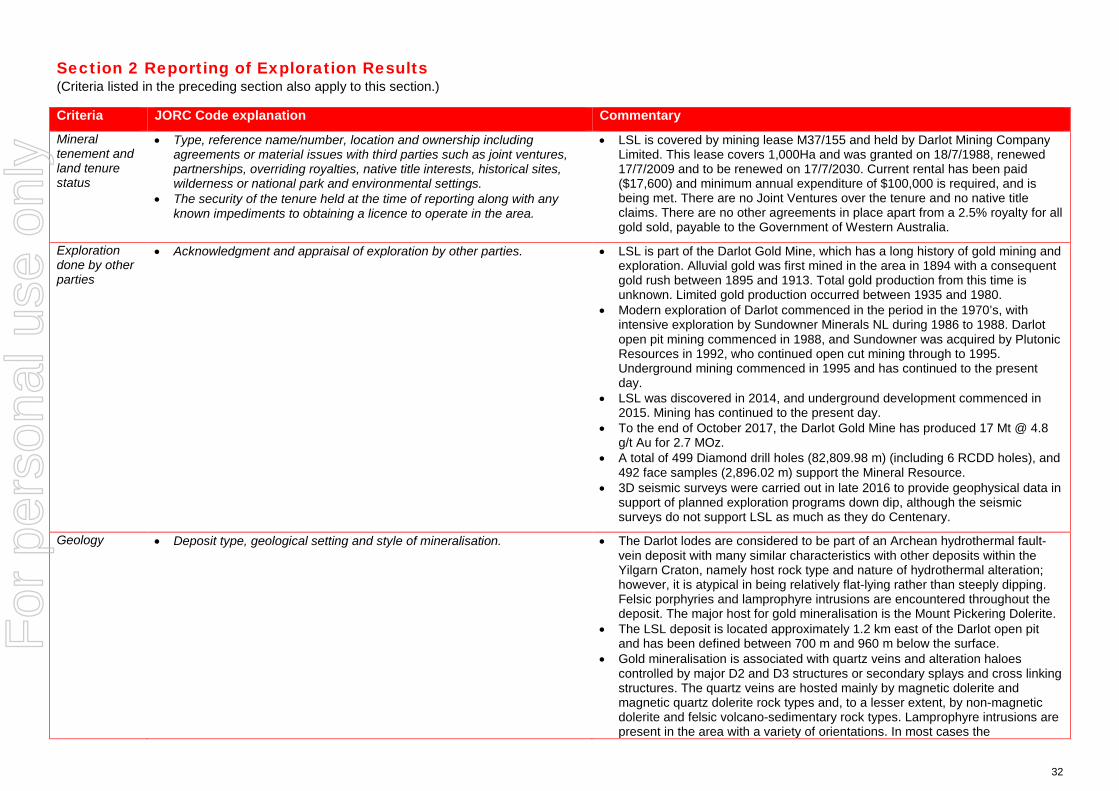
32
Section 2 Reporting of Exploration Results (Criteria listed in the preceding section also apply to this section.)
Criteria JORC Code explanation Commentary
Mineral tenement and land tenure status
• Type, reference name/number, location and ownership including agreements or material issues with third parties such as joint ventures, partnerships, overriding royalties, native title interests, historical sites, wilderness or national park and environmental settings.
• The security of the tenure held at the time of reporting along with any known impediments to obtaining a licence to operate in the area.
• LSL is covered by mining lease M37/155 and held by Darlot Mining Company Limited. This lease covers 1,000Ha and was granted on 18/7/1988, renewed 17/7/2009 and to be renewed on 17/7/2030. Current rental has been paid ($17,600) and minimum annual expenditure of $100,000 is required, and is being met. There are no Joint Ventures over the tenure and no native title claims. There are no other agreements in place apart from a 2.5% royalty for all gold sold, payable to the Government of Western Australia.
Exploration done by other parties
• Acknowledgment and appraisal of exploration by other parties. • LSL is part of the Darlot Gold Mine, which has a long history of gold mining and exploration. Alluvial gold was first mined in the area in 1894 with a consequent gold rush between 1895 and 1913. Total gold production from this time is unknown. Limited gold production occurred between 1935 and 1980.
• Modern exploration of Darlot commenced in the period in the 1970’s, with intensive exploration by Sundowner Minerals NL during 1986 to 1988. Darlot open pit mining commenced in 1988, and Sundowner was acquired by Plutonic Resources in 1992, who continued open cut mining through to 1995. Underground mining commenced in 1995 and has continued to the present day.
• LSL was discovered in 2014, and underground development commenced in 2015. Mining has continued to the present day.
• To the end of October 2017, the Darlot Gold Mine has produced 17 Mt @ 4.8 g/t Au for 2.7 MOz.
• A total of 499 Diamond drill holes (82,809.98 m) (including 6 RCDD holes), and 492 face samples (2,896.02 m) support the Mineral Resource.
• 3D seismic surveys were carried out in late 2016 to provide geophysical data in support of planned exploration programs down dip, although the seismic surveys do not support LSL as much as they do Centenary.
Geology • Deposit type, geological setting and style of mineralisation. • The Darlot lodes are considered to be part of an Archean hydrothermal fault-vein deposit with many similar characteristics with other deposits within the Yilgarn Craton, namely host rock type and nature of hydrothermal alteration; however, it is atypical in being relatively flat-lying rather than steeply dipping. Felsic porphyries and lamprophyre intrusions are encountered throughout the deposit. The major host for gold mineralisation is the Mount Pickering Dolerite.
• The LSL deposit is located approximately 1.2 km east of the Darlot open pit and has been defined between 700 m and 960 m below the surface.
• Gold mineralisation is associated with quartz veins and alteration haloes controlled by major D2 and D3 structures or secondary splays and cross linking structures. The quartz veins are hosted mainly by magnetic dolerite and magnetic quartz dolerite rock types and, to a lesser extent, by non-magnetic dolerite and felsic volcano-sedimentary rock types. Lamprophyre intrusions are present in the area with a variety of orientations. In most cases the
For
per
sona
l use
onl
y

33
Criteria JORC Code explanation Commentary
lamprophyres are thought to be pre-mineralisation but are an un-favorable host rock for mineralisation and in most cases are barren.
• The wing veins associated with the mineralisation typically dip to the NW and SE at around 15° with the associated Lords, (Walters and SRCG) faults being mainly quartz filled structures dipping at around 40°. The mining history of LSL and associated reconciliations has proven the veracity of this model.
• Mineralisation is hosted by a fractionated Dolerite sill within the greater Mt Pickering dolerite syncline, with silica+/-albite+/-carbonate+/-pyrite+/-gold being the key alteration components.
Drill hole Information
• A summary of all information material to the understanding of the exploration results including a tabulation of the following information for all Material drill holes: o easting and northing of the drill hole collar o elevation or RL (Reduced Level – elevation above sea level in metres)
of the drill hole collar o dip and azimuth of the hole o down hole length and interception depth o hole length.
• If the exclusion of this information is justified on the basis that the information is not Material and this exclusion does not detract from the understanding of the report, the Competent Person should clearly explain why this is the case.
• Drill hole information from Darlot drill programs, predominantly diamond core and face sampling, were used to support the Mineral Resource estimate. The locations of drill samples, and the geological logs of these samples were used to build the geological model, and with the sample analyses, support the Mineral Resource estimate.
Data aggregation methods
• In reporting Exploration Results, weighting averaging techniques, maximum and/or minimum grade truncations (eg cutting of high grades) and cut-off grades are usually Material and should be stated.
• Where aggregate intercepts incorporate short lengths of high grade results and longer lengths of low grade results, the procedure used for such aggregation should be stated and some typical examples of such aggregations should be shown in detail.
• The assumptions used for any reporting of metal equivalent values should be clearly stated.
• Exploration results are not reported here, with most drill holes and face samples used to support the Mineral Resource estimate. Sludge samples are recorded in the drill hole database but were not used in the Mineral Resource estimate due insufficient reliability of sampling methods.
Relationship between mineralisation widths and intercept lengths
• These relationships are particularly important in the reporting of Exploration Results.
• If the geometry of the mineralisation with respect to the drill hole angle is known, its nature should be reported.
• If it is not known and only the down hole lengths are reported, there should be a clear statement to this effect (eg ‘down hole length, true width not known’).
• From mapping and diamond drilling, mineralisation appear to be dipping approximately 15° to the north west. Drillholes are angled to drill as close to perpendicular to mineralisation as possible, although this is difficult when drilling from underground locations, targeting lode positions along strike from the drill cuddies.
• Intercepts reported are downhole length, and true width can generally be calculated because the dip of the lode is known.
Diagrams • Appropriate maps and sections (with scales) and tabulations of intercepts should be included for any significant discovery being reported These should include, but not be limited to a plan view of drill hole collar locations and appropriate sectional views.
• Isometric view representing the Darlot deposit (including Lord South Lower Resource) is included in the body of this report.
Balanced • Where comprehensive reporting of all Exploration Results is not practicable, representative reporting of both low and high grades and/or
• Exploration results are not reported here, with all drill holes used to support the
For
per
sona
l use
onl
y
34
Criteria JORC Code explanation Commentary
reporting widths should be practiced to avoid misleading reporting of Exploration Results.
Mineral Resource estimate.
Other substantive exploration data
• Other exploration data, if meaningful and material, should be reported including (but not limited to): geological observations; geophysical survey results; geochemical survey results; bulk samples – size and method of treatment; metallurgical test results; bulk density, groundwater, geotechnical and rock characteristics; potential deleterious or contaminating substances.
• LSL is part of the Darlot Gold Mine, and the lodes were geologically mapped in underground exposures. The geological mapping provided a foundation for the interpretation of the geological models.
• Metallurgical testwork carried out in 2014 on a 55kg composited drill core sample demonstrated a recovery of 95% for LSL ore.
• Bulk density testwork is discussed in Section 3 of this table. Testwork on the sample discussed in the previous point resulted in a density of 2.92 t/m3, supporting the value of 2.9 assigned to the Mineral Resource model. Other samples were tested using the water immersion technique. Fresh core billets (not weathered) were not required to be wax coated prior to immersion.
Further work • The nature and scale of planned further work (eg tests for lateral extensions or depth extensions or large-scale step-out drilling).
• Diagrams clearly highlighting the areas of possible extensions, including the main geological interpretations and future drilling areas, provided this information is not commercially sensitive.
• LSL is open along strike and down dip, with potential for additional gold mineralisation in these directions.
• Plans are currently being formulated for exploration drilling to test these targets.
For
per
sona
l use
onl
y
35
Section 3 Estimation and Reporting of Mineral Resources (Criteria listed in section 1, and where relevant in section 2, also apply to this section.)
Criteria JORC Code explanation Commentary
Database integrity
• Measures taken to ensure that data has not been corrupted by, for example, transcription or keying errors, between its initial collection and its use for Mineral Resource estimation purposes.
• Data validation procedures used.
• Data is entered directly into the data capture system in the field and reviewed by a geologist before being imported to the main database. Geological Logging at Darlot is collected by geologists and entered directly into an Acquire Database on a laptop computer. Logging is regularly checked by a senior company geologist to ensure the veracity and consistency of the data.
• Logs cannot be finalised if key fields are missing, nor can codes not existing in the library be entered, ensuring continuity of data, and reducing data entry and transcription errors.
• Once in the main database, only the database administrators can edit or change data, and all changes are logged by the system.
Site visits • Comment on any site visits undertaken by the Competent Person and the outcome of those visits.
• If no site visits have been undertaken indicate why this is the case.
• The Competent Person(s) (CP) are based on site at Darlot and are familiar with the geological setting of the deposit, sampling protocols, quality control and quality assurance (QA/QC) of sample data, resource modelling procedures, current site procedures and policies, and are confident that all data collected is verifiable and has been collected in line with industry best practices to support a Mineral Resource Estimate.
Geological interpretation
• Confidence in (or conversely, the uncertainty of ) the geological interpretation of the mineral deposit.
• Nature of the data used and of any assumptions made. • The effect, if any, of alternative interpretations on Mineral Resource
estimation. • The use of geology in guiding and controlling Mineral Resource
estimation. • The factors affecting continuity both of grade and geology.
• Gold mineralisation is associated with quartz veins and alteration haloes controlled by major D2 and D3 structures or secondary splays and cross linking structures. The quartz veins are hosted mainly by magnetic dolerite and magnetic quartz dolerite rock types and, to a lesser extent, by non-magnetic dolerite and felsic volcano-sedimentary rock types. Lamprophyre intrusions are present in the area with a variety of orientations. In most cases the lamprophyres are thought to be pre-mineralisation but are an un-favorable host rock for mineralisation and in most cases are barren.
• The wing veins associated with the mineralisation typically dip to the NW and SE at around 15° with the associated Lords, (Walters and SRCG) faults being mainly quartz filled structures dipping at around 40°. The mining history of Lords South Lower (LSL) and associated reconciliations has proven the veracity of this model.
• The sample data for the LSL includes diamond drilling (DD) and reverse circulation (RC) with DD tail. Underground face samples taken by mine geologists were also included. Some holes were excluded due to erroneous collar and down-hole surveys and a default grade of 0.005g/t was assigned where the gold grade was absent. The interpretations supporting the geological models are predominantly based upon drill hole samples.
• All geological interpretations for the LSL are prepared in Darlot Mine Grid. • The LSL Orebody has been continuously mined since 2015 and alternative
interpretations have not been considered as the geological controls are generally well understood.
• The LSL Deposit is sub-divided into six mineralised domains based on geology
For
per
sona
l use
onl
y
36
Criteria JORC Code explanation Commentary
and structure, with the steeper fault hosted domains such as Walters, Lords and SRCG areas separated from the flatter wing vein hosted mineralisation such as the hanging-wall and foot-wall flat lodes. Those domains with similar characteristics were grouped geo-statistically.
• The site geologists prepared the interpretations of the mineralised lodes within these six domains and the 100 lodes are modeled as individual wireframes.
• The grade in the ore bodies is controlled by both structure and host lithology, in that typically the best grades are hosted by the Magnetic Dolerite and Felsic intrusions, with comparatively lesser grades observed in the other host rocks such as the non-magnetic dolerite. Consequently host lithology for lodes was a key factor considered for the estimate.
Dimensions • The extent and variability of the Mineral Resource expressed as length (along strike or otherwise), plan width, and depth below surface to the upper and lower limits of the Mineral Resource.
• The LSL deposit has an overall strike length of about 900 m and a width of about 600 m and extends from about 700m to 960m below the natural surface.
Estimation and modelling techniques
• The nature and appropriateness of the estimation technique(s) applied and key assumptions, including treatment of extreme grade values, domaining, interpolation parameters and maximum distance of extrapolation from data points. If a computer assisted estimation method was chosen include a description of computer software and parameters used.
• The availability of check estimates, previous estimates and/or mine production records and whether the Mineral Resource estimate takes appropriate account of such data.
• The assumptions made regarding recovery of by-products. • Estimation of deleterious elements or other non-grade variables of
economic significance (eg sulphur for acid mine drainage characterisation).
• In the case of block model interpolation, the block size in relation to the average sample spacing and the search employed.
• Any assumptions behind modelling of selective mining units. • Any assumptions about correlation between variables. • Description of how the geological interpretation was used to control the
resource estimates. • Discussion of basis for using or not using grade cutting or capping. • The process of validation, the checking process used, the comparison of
model data to drill hole data, and use of reconciliation data if available.
• As previously noted, the Mineral Resource estimate has been divided into six (6) domains for the purpose of resource estimation. The model was constructed with manual wireframing in Vulcan software.
• The 100 wireframes mentioned above were imported directly into Vulcan for grade estimation and resource reporting.
• Vulcan was used for block modelling, grade interpolation, and Mineral Resource classification and reporting. Snowden Supervisor was used for geostatistical analyses. The Au domain interpretations were based upon both geology and grade.
• The interpreted mineralisation for the Main Lords structure wireframe encompasses a broad area in parts, with gold grades that vary from poorly mineralised through to significantly mineralised within. To improve definition of the higher grades within the mineralised Lords domain an indicator estimation method, based on ≥ 1 g/t Au and ≥ 3 g/t Au composited drill hole grade thresholds, was applied. The two thresholds are selected to identify areas of lower grade gold mineralisation from the high grade gold mineralisation and the threshold of 3 g/t Au is intentionally below the Mineral Resource reporting cut-off and the Ore Reserves reporting cut-off.
• Significant amounts of lamprophyre which are generally barren cross-cut some of the lodes, some of the larger ones were wire-framed by the site geologists, while a categorical estimation technique was applied to model out the less continuous dykes, based on an indicator kriging technique. These areas are then flagged as waste in the final model.
• The LSL lodes have been mined since 2015 and mostly positive mine to mill reconciliations have proven the veracity of the model. No check estimates are known to have been completed.
• No significant amounts of deleterious elements have historically been encountered or estimated in the LSL deposit, and hence have never been considered for estimation in the Mineral Resource. Pyrite does not occur in
For
per
sona
l use
onl
y
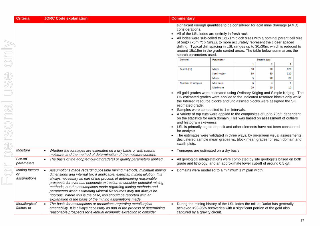
37
Criteria JORC Code explanation Commentary
significant enough quantities to be considered for acid mine drainage (AMD) considerations.
• All of the LSL lodes are entirely in fresh rock • All lodes were sub-celled to 1x1x1m block sizes with a nominal parent cell size
of 5m(X) x5m(Y) x 5m(Z), to more accurately represent the closer spaced drilling. Typical drill spacing in LSL ranges up to 30x30m, which is reduced to around 15x15m in the grade control areas. The table below summarizes the search parameters used.
• All gold grades were estimated using Ordinary Kriging and Simple Kriging. The
OK estimated grades were applied to the Indicated resource blocks only while the Inferred resource blocks and unclassified blocks were assigned the SK estimated grade.
• Samples were composited to 1 m intervals. • A variety of top cuts were applied to the composites of up to 70g/t; dependent
on the statistics for each domain. This was based on assessment of outliers and histogram skewness.
• LSL is primarily a gold deposit and other elements have not been considered for analysis.
• The estimates were validated in three ways, by on-screen visual assessments, declustered sample mean grades vs. block mean grades for each domain and swath plots.
Moisture • Whether the tonnages are estimated on a dry basis or with natural moisture, and the method of determination of the moisture content.
• Tonnages are estimated on a dry basis.
Cut-off parameters
• The basis of the adopted cut-off grade(s) or quality parameters applied. • All geological interpretations were completed by site geologists based on both grade and lithology, and an approximate lower cut-off of around 0.5 g/t.
Mining factors or assumptions
• Assumptions made regarding possible mining methods, minimum mining dimensions and internal (or, if applicable, external) mining dilution. It is always necessary as part of the process of determining reasonable prospects for eventual economic extraction to consider potential mining methods, but the assumptions made regarding mining methods and parameters when estimating Mineral Resources may not always be rigorous. Where this is the case, this should be reported with an explanation of the basis of the mining assumptions made.
• Domains were modelled to a minimum 1 m plan width.
Metallurgical factors or
• The basis for assumptions or predictions regarding metallurgical amenability. It is always necessary as part of the process of determining reasonable prospects for eventual economic extraction to consider
• During the mining history of the LSL lodes the mill at Darlot has generally achieved >93-95% recoveries with a significant portion of the gold also captured by a gravity circuit.
For
per
sona
l use
onl
y

38
Criteria JORC Code explanation Commentary
assumptions potential metallurgical methods, but the assumptions regarding metallurgical treatment processes and parameters made when reporting Mineral Resources may not always be rigorous. Where this is the case, this should be reported with an explanation of the basis of the metallurgical assumptions made.
• Metallurgical testwork carried out in 2014 on a 55kg composited drill core sample demonstrated a recovery of 95% for LSL ore.
Environmen-tal factors or assumptions
• Assumptions made regarding possible waste and process residue disposal options. It is always necessary as part of the process of determining reasonable prospects for eventual economic extraction to consider the potential environmental impacts of the mining and processing operation. While at this stage the determination of potential environmental impacts, particularly for a greenfields project, may not always be well advanced, the status of early consideration of these potential environmental impacts should be reported. Where these aspects have not been considered this should be reported with an explanation of the environmental assumptions made.
• Darlot has had an extensive mining history and as such has full infrastructure for the treatment of processing and mining residues.
• Darlot is certified as ISO14001 compliant for environmental management and is also certified for International Cyanide Management Code.
Bulk density • Whether assumed or determined. If assumed, the basis for the assumptions. If determined, the method used, whether wet or dry, the frequency of the measurements, the nature, size and representativeness of the samples.
• The bulk density for bulk material must have been measured by methods that adequately account for void spaces (vugs, porosity, etc), moisture and differences between rock and alteration zones within the deposit.
• Discuss assumptions for bulk density estimates used in the evaluation process of the different materials.
• A dry (in situ) bulk density of 2.90 t/m3 has been used for all lithologies. This value has been historically assigned for the Darlot project area.
• Metallurgical testwork (2014) on the sample discussed in Section 2 resulted in a density of 2.92 t/m3, supporting the value of 2.90 assigned to the Mineral Resource model.
• Data is available for bulk density determinations and is recorded in Red 5 Limited’s database, and was assessed by previous operators of the Darlot Gold Mine. The CP is satisfied that the value used is verifiable and typical given their knowledge and experience in similar deposits in the Eastern Goldfields of Western Australia.
• All the bulk density records that have been sighted were determined by the Archimedes method of immersion in water, with no wax coating required as porosity is not an issue in Darlot host rocks. These samples are considered representative of the lodes and waste zones.
Classification • The basis for the classification of the Mineral Resources into varying confidence categories.
• Whether appropriate account has been taken of all relevant factors (ie relative confidence in tonnage/grade estimations, reliability of input data, confidence in continuity of geology and metal values, quality, quantity and distribution of the data).
• Whether the result appropriately reflects the Competent Person’s view of the deposit.
• The Mineral Resource is classified as Indicated and Inferred. • The geological evidence for mineralisation occurrence and continuity was
observed in drill samples and significant underground workings on the LSL lodes. For classification of Indicated; a drill spacing of <30 x 30 m was required. For classification of Inferred; < 60 x 60 m. Any blocks outside these parameters were unclassified. Drill sampling and analytical techniques for DD and RC drilling as well as face sampling are well documented by Red 5 Limited, as well as rigorous QAQC protocols and documentation to support an Indicated Resource Classification where geological confidence allows.
• The classification of the Mineral Resource took into account the geological understanding of the deposit, quality of the samples, quality and quantity of density data, drill hole spacing, and the quality of the block grade estimates. Geological understanding and quality of samples is sufficient to assume geological and grade continuity in the Indicated volumes.
• All relevant factors have been taken into account when determining the resource classification for LSL deposit, and the results are deemed by the CP
For
per
sona
l use
onl
y

39
Criteria JORC Code explanation Commentary
to be fair and relevant.
Audits or reviews
• The results of any audits or reviews of Mineral Resource estimates. • The Mineral Resource Estimate was peer reviewed internally by Goldfields Australia.
Discussion of relative accuracy/ confidence
• Where appropriate a statement of the relative accuracy and confidence level in the Mineral Resource estimate using an approach or procedure deemed appropriate by the Competent Person. For example, the application of statistical or geostatistical procedures to quantify the relative accuracy of the resource within stated confidence limits, or, if such an approach is not deemed appropriate, a qualitative discussion of the factors that could affect the relative accuracy and confidence of the estimate.
• The statement should specify whether it relates to global or local estimates, and, if local, state the relevant tonnages, which should be relevant to technical and economic evaluation. Documentation should include assumptions made and the procedures used.
• These statements of relative accuracy and confidence of the estimate should be compared with production data, where available.
• The Mineral Resource estimate is considered a global resource for both Indicated and Inferred Resource estimations.
• The CP is comfortable that the 2 years LSL production records of mining and reconciliation is sufficient to verify the veracity of the estimate.
• Fully surveyed voids have been used to deplete the model of already mined material.
For
per
sona
l use
onl
y

40
JORC Code, 2012 Edition – Table 1 for the CDA Oval Resource – Part of the Darlot Deposit
Section 1 Sampling Techniques and Data (Criteria in this section apply to all succeeding sections.)
Criteria JORC Code explanation Commentary
Sampling techniques
• Nature and quality of sampling (eg cut channels, random chips, or specific specialised industry standard measurement tools appropriate to the minerals under investigation, such as down hole gamma sondes, or handheld XRF instruments, etc). These examples should not be taken as limiting the broad meaning of sampling.
• Include reference to measures taken to ensure sample representivity and the appropriate calibration of any measurement tools or systems used.
• Aspects of the determination of mineralisation that are Material to the Public Report.
• In cases where ‘industry standard’ work has been done this would be relatively simple (eg ‘reverse circulation drilling was used to obtain 1 m samples from which 3 kg was pulverised to produce a 30 g charge for fire assay’). In other cases more explanation may be required, such as where there is coarse gold that has inherent sampling problems. Unusual commodities or mineralisation types (eg submarine nodules) may warrant disclosure of detailed information.
• Diamond core (DD) drilling provided pulverised chips and competent lengths of core samples. Face sampling was converted to dummy drill holes and included in the database. Drill hole data supporting the Mineral Resource contains 287 unique drill hole IDs for a total sample length of 55,477.76 m. Sludge samples were excluded from the drill hole data files due to lack of quality assurance regarding sampling.
• A total of 139 Diamond drill holes (54,704.42 m), (including 23 RCDD holes), and 148 face samples (773.34 m) support the Mineral Resource.
• Diamond core is predominantly NQ2 with some HQ and was cleaned, laid out, measured and logged in its entirety. Core is marked up with a maximum core length of 1 m, depending on core size. Some core is whole sampled (full core collection) when necessary, but most core is half cut core. Digital photographs are taken and stored for reference purposes. Where possible core is cut in half with one half only being submitted for analysis at the Laboratory, with the other half is stored in the core farm for reference.
Drilling techniques
• Drill type (eg core, reverse circulation, open-hole hammer, rotary air blast, auger, Bangka, sonic, etc) and details (eg core diameter, triple or standard tube, depth of diamond tails, face-sampling bit or other type, whether core is oriented and if so, by what method, etc).
• The sample data for the Centenary Depth Analogue Oval (CDA Oval) area includes diamond drilling (DD), underground face samples (FACE), and reverse circulation holes with diamond core tails (RCDD). The data was collected during 2015 to present.
• Underground DDH is usually NQ2 or LTK60. • Underground face sampling was carried out by the mine geologist painting a
sample line orthogonal to the dip of the quartz veining and sampled according to geological intervals. Samples were bagged and ticketed with unique sample IDs and dispatched to the assay laboratory.
Drill sample recovery
• Method of recording and assessing core and chip sample recoveries and results assessed.
• Measures taken to maximise sample recovery and ensure representative nature of the samples.
• Whether a relationship exists between sample recovery and grade and whether sample bias may have occurred due to preferential loss/gain of fine/coarse material.
• Drill sample recoveries are recorded for each sample number and stored in the Acquire database. Diamond core samples were geotechnically logged and sample recoveries calculated. Most drill samples penetrating mineralisation are diamond core.
• Core recovery factors for core drilling are generally very high typically in excess of 95% recovery. Some loss occurs locally when drilling through fault/shear zones. Face sampling, by its nature, can be a biased sampling method, relying on manual ‘picking’ of the face by either a geological hammer, or by a Jumbo scraping sample material off the face and collected by the mine geologist. Face sampling can be regarded as having 100% sample recovery, however the Competent Person is cognisant of sampling bias. The use of face samples in grade estimation is provided in Section 3.
For
per
sona
l use
onl
y

41
Criteria JORC Code explanation Commentary
• Periodic reviews of early drilling assay results and bias may be done form time to time where required on historical prospects where new drilling is done. Q-Q Plots of the re-drills and original holes are correlated and any bias (positive / negative) identified. This is utilised in any future interpretations and modelling.
• The supervising geologist monitored the diamond core recoveries and discussed any shortcoming with the driller. Recoveries are generally very good however.
Logging • Whether core and chip samples have been geologically and geotechnically logged to a level of detail to support appropriate Mineral Resource estimation, mining studies and metallurgical studies.
• Whether logging is qualitative or quantitative in nature. Core (or costean, channel, etc) photography.
• The total length and percentage of the relevant intersections logged.
• A geologist was present at all times during drilling and sampling. Geological logging protocols at the time of drilling were followed to ensure consistency in drill logs between the geological staff.
• Diamond core were logged for lithology, structure, stratigraphy, mineralisation, alteration, geophysical (magnetic properties) and geochemical properties (multi-element assays) and physical measurements (rock hardness, geotechnical RQD's, density, acid rock drainage (ARD)).
• The full sample lengths were logged. Core was photographed (mostly wet).
Sub-sampling techniques and sample preparation
• If core, whether cut or sawn and whether quarter, half or all core taken. • If non-core, whether riffled, tube sampled, rotary split, etc and whether
sampled wet or dry. • For all sample types, the nature, quality and appropriateness of the
sample preparation technique. • Quality control procedures adopted for all sub-sampling stages to
maximise representivity of samples. • Measures taken to ensure that the sampling is representative of the in
situ material collected, including for instance results for field duplicate/second-half sampling.
• Whether sample sizes are appropriate to the grain size of the material being sampled.
• DD core sample lengths can be variable in a mineralized zone, though usually no larger than one-metre. This enables the capture of assay data for narrow structures and localized grade variations.
• Grade control drill holes are sampled as whole core. DD samples are taken according to a cut sheet compiled by the geologist. Half or full core samples are bagged in pre-numbered calico bags and submitted with a sample submission form.
• DD core is cut by a getoech field assistant. • The sampling protocols for both DD and Face are considered appropriate for
the style of mineralisation. • A summary of the sample preparation process is as below:
o Oven dried at 105ºC. o Jaw crushed to -12 mm. o If sample >3kg, Boyd crusher to 3 mm, and riffle split to <3kg. o Pulverised in LM5. o 250-300 g pulp sample taken. o Remainder of pulp returned to calico sample bag.
• Quality Control (QC) samples are inserted at a rate of 1 in 20. All standards used are Certified Reference Materials (CRM). The insertion of blanks is under the control of the geologist and CRMs are usually inserted one per batch.
• Sample sizes are considered appropriate to the grain size of the material being sampled.
Quality of assay data and laboratory tests
• The nature, quality and appropriateness of the assaying and laboratory procedures used and whether the technique is considered partial or total.
• For geophysical tools, spectrometers, handheld XRF instruments, etc, the parameters used in determining the analysis including instrument make and model, reading times, calibrations factors applied and their derivation, etc.
• Primary assaying of face samples and DD samples has been undertaken by ALS Kalgoorlie for considerable time. Documentation regarding more historical holes and their sample analyses are not well documented. Analysis is by 50g fire assay (FA) with Atomic Absorption Spectrometer (AAS) finish to 0.01 g/t detection limit. Given the occurrence of coarse gold, Screen Fire Assays (SFA) checks are periodically undertaken.
For
per
sona
l use
onl
y
42
Criteria JORC Code explanation Commentary
• Nature of quality control procedures adopted (eg standards, blanks, duplicates, external laboratory checks) and whether acceptable levels of accuracy (ie lack of bias) and precision have been established.
• The processes are considered total. • Previous operators employed a comprehensive QA/QC regime with CRMs,
blanks, quartz flush checks and grind checks routinely monitored. Coarse duplicates from crush residue, and pulp duplicates from pulp residues were regularly monitored to test the quality of sub sampling stages. Results are documented on a quarterly basis, with any failures or irregularities investigated and actions taken to correct the issue. Regular communications were had with ALS.
• Umpire analyses were undertaken at Independent Assay Laboratories (IAL) for selected samples comprising a 100 sample batch. Results show a reasonable correlation with the original samples, with differences largely attributable to nugget effects.
• Acceptable levels of accuracy and precision were established prior to accepting the sample data as support for the Mineral Resource estimate.
• The QAQC procedures and results show acceptable levels of accuracy and precision were established.
Verification of sampling and assaying
• The verification of significant intersections by either independent or alternative company personnel.
• The use of twinned holes. • Documentation of primary data, data entry procedures, data verification,
data storage (physical and electronic) protocols. • Discuss any adjustment to assay data.
• CDA Oval is a recently discovered deposit within Darlot Gold Mine, and intersections with significant Au grade are not unknown. Visible Au is often observed. If core samples with significant intersections are logged then alternative geological personnel are likely to review and confirm the results.
• No twin drilling has occurred at CDA Oval. • All data at Darlot is stored in an SQL relational database format using acQuire
software. acQuire enables definition of tasks, permission management and database integrity. The SQL Server database is configured for optimal validation through constraints, library tables and triggers. Data that fails these rules on import is rejected and not ranked as a priority to be used for exports or any data applications.
• All exploration data control is managed centrally, from drill-hole planning to final assay, survey and geological capture. The majority of logging data (lithology, alteration, and structural characteristics of core) is captured directly either by manual or to customised digital logging tools with stringent validation and data entry constraints. Geologists load data in the acquire database where initial validation of the data occurs. The data are uploaded into the database by the geologist after which ranking of the data happen based on multiple QAQC and validation rules.
• All assay data is uploaded into the database in a text format known as a sif. These files include detailed information about the batch, methods, units, detection limits and elements assayed. The file also includes all QC data in the sequence of analysis. The assay data is stored in a flattened format to ensure all required information is stored for each sample, and that multiple assay results are stored for each sample.
• Data validation is controlled via rules, library tables and triggers. Once all data
For
per
sona
l use
onl
y
43
Criteria JORC Code explanation Commentary
for a drill-hole have been entered into the database, the geologist responsible for the drilling program validates each drill-hole. A standard validation trigger in the acquire database run queries against the data, which includes checks for; incorrect collar locations, testing for overlapping, missing or incorrect down-hole surveys, and incorrect collar location.
• A digital certified assay certificate in Adobe PDF format is backed up on the Darlot server on a regular schedule. A copy of the database also resides on the Red 5 back-up server in Perth.
• The database is secure and password protected by the Database Administrator to prevent accidental or malicious adjustment to data.
• No adjustments are made to the data.
Location of data points
• Accuracy and quality of surveys used to locate drill holes (collar and down-hole surveys), trenches, mine workings and other locations used in Mineral Resource estimation.
• Specification of the grid system used. • Quality and adequacy of topographic control.
• Collars are marked out pre-drilling and surveyed post-drilling by licensed surveyors. All recent DD holes were surveyed down the hole by Reflex non-magnetic multi shot gyro survey. Down hole surveys are routinely undertaken by the drilling contractor and verified by the mine geologist.
• Drill hole collars are located respective to the local mine grid and to the overall property in UTM MGA94-Zone51. Mine grid north is 44° west of north Australian Map Grid, and all mining Mineral Resource and Ore Reserve work is carried out in Mine Grid. Reduced Level (RL) for surface drilling is calculated by adding 1,000 m to surface elevation, while the underground RL is calculated by taking the surface RL minus the vertical depth to the point being referenced.
• Underground voids are surveyed by mine surveyors. The survey control on these voids is considered adequate to support the depletion of the Mineral Resource model.
Data spacing and distribution
• Data spacing for reporting of Exploration Results. • Whether the data spacing and distribution is sufficient to establish the
degree of geological and grade continuity appropriate for the Mineral Resource and Ore Reserve estimation procedure(s) and classifications applied.
• Whether sample compositing has been applied.
• Typical drill spacing in CDA Oval ranges up to 40x40m, which is reduced to around 15x15m in the grade control areas.
• The Competent Person considers the data spacing to be sufficient to establish the degree of geological and grade continuity appropriate for the Mineral Resource classification categories adopted for Centenary.
• Samples were not composited prior to dispatch for analyses.
Orientation of data in relation to geological structure
• Whether the orientation of sampling achieves unbiased sampling of possible structures and the extent to which this is known, considering the deposit type.
• If the relationship between the drilling orientation and the orientation of key mineralised structures is considered to have introduced a sampling bias, this should be assessed and reported if material.
• CDA Oval was drilled by a combination of underground diamond holes and face sampling, with each face sample trace assigned a drill hole collar ID. Underground drilling is confined to drill cuddies and the orientation of exploration holes is often oblique to the mineralisation. Face sampling traces are aligned orthogonal to the dip of the mineralisation, as exposed in the face, whenever possible.
• Resultant sampling bias, particularly from face sampling, is usually retained in the drill database and any potential impact upon the Mineral Resource was not assessed. The Competent Person does not believe any potential impacts to be material in terms of grade interpolation.
Sample • The measures taken to ensure sample security. • Although security in not strongly enforced, Darlot is a remote site and the number of outside visitors is small. The deposit is known to contain visible gold
For
per
sona
l use
onl
y

44
Criteria JORC Code explanation Commentary
security and this renders the core susceptible to theft, however the risk of sample tampering is considered low.
• ALS Kalgoorlie organise transport companies to pick up bagged samples from a secured locality at the mine site. These are then transported to the laboratory facility for further preparation and assaying. All samples received by the laboratory are physically checked against the despatch order and Darlot is notified of any discrepancies prior to sample preparation commencing. No Red 5 personnel are involved in the preparation or analysis process.
Audits or reviews
• The results of any audits or reviews of sampling techniques and data. • A series of written standard procedures exists for sampling and core cutting at Darlot. Periodic routine visits to drill rigs and the core farm are carried out by project geologists and Senior Geologists / Superintendents to review core logging and sampling practices. There were no adverse findings, and any minor deficiencies were noted and staff notified, with remedial training if required.
For
per
sona
l use
onl
y

45
Section 2 Reporting of Exploration Results (Criteria listed in the preceding section also apply to this section.)
Criteria JORC Code explanation Commentary
Mineral tenement and land tenure status
• Type, reference name/number, location and ownership including agreements or material issues with third parties such as joint ventures, partnerships, overriding royalties, native title interests, historical sites, wilderness or national park and environmental settings.
• The security of the tenure held at the time of reporting along with any known impediments to obtaining a licence to operate in the area.
• CDA Oval is covered by mining lease M37/155 and held by Darlot Mining Company Limited. This lease covers 1,000Ha and was granted on 18/7/1988, renewed 17/7/2009 and to be renewed on 17/7/2030. Current rental has been paid ($17,600) and minimum annual expenditure of $100,000 is required, and is being met. There are no Joint Ventures over the tenure and no native title claims. There are no other agreements in place apart from a 2.5% royalty for all gold sold, payable to the Government of Western Australia.
Exploration done by other parties
• Acknowledgment and appraisal of exploration by other parties. • CDA Oval is part of the Darlot Gold Mine, which has a long history of gold mining and exploration. Alluvial gold was first mined in the area in 1894 with a consequent gold rush between 1895 and 1913. Total gold production from this time is unknown. Limited gold production occurred between 1935 and 1980.
• Modern exploration of Darlot commenced in the period in the 1970’s, with intensive exploration by Sundowner Minerals NL during 1986 to 1988. Darlot open pit mining commenced in 1988, and Sundowner was acquired by Plutonic Resources in 1992, who continued open cut mining through to 1995. Underground mining commenced in 1995 and has continued to the present day.
• CDA Oval was discovered in 2015, and underground development commenced in 2016. Mining has continued to the present day.
• To the end of October 2017, the Darlot Gold Mine has produced 17 Mt @ 4.8 g/t Au for 2.7 MOz.
• A total of 139 Diamond drill holes (54,704.42 m), (including 23 RCDD holes), and 148 face samples (773.34 m) support the Mineral Resource.
• 3D seismic surveys were carried out in late 2016 to provide geophysical data in support of planned exploration programs.
Geology • Deposit type, geological setting and style of mineralisation. • The Darlot lodes are considered to be part of an Archean hydrothermal fault-vein deposit with many similar characteristics with other deposits within the Yilgarn Craton, namely host rock type and nature of hydrothermal alteration; however, it is atypical in being relatively flat-lying rather than steeply dipping. Felsic porphyries and lamprophyre intrusions are encountered throughout the deposit. The major host for gold mineralisation is the Mount Pickering Dolerite.
• The CDA Oval deposit is located approximately 0.5 km east of the Darlot open pit and has been defined between 470 m and 1,200 m below the surface.
• Gold mineralisation is associated with quartz veins and alteration haloes controlled by major D2 and D3 structures or secondary splays and cross linking structures. The quartz veins are hosted mainly by magnetic dolerite and magnetic quartz dolerite rock types and, to a lesser extent, by non-magnetic dolerite and felsic volcano-sedimentary rock types. Lamprophyre intrusions are present in the area with a variety of orientations. In most cases the lamprophyres are thought to be pre-mineralisation but are an un-favorable host
For
per
sona
l use
onl
y
46
Criteria JORC Code explanation Commentary
rock for mineralisation and in most cases are barren. • The hanging-wall and foot-wall veins associated with the CDA Oval
mineralisation typically dip to the NW between ~5° and 25° with the Main Oval structure dipping at around 45° to the NW. The CDA Oval deposit also encompasses the Twelfth man and Burswood fault structures which are similar to the Oval and dip at ~70° to the NW too. The recent mining history of the CDA Oval area and associated reconciliations has proven the veracity of this model.
• Mineralisation is hosted by a fractionated Dolerite sill within the greater Mt Pickering dolerite syncline, with silica+/-albite+/-carbonate+/-pyrite+/-gold being the key alteration components.
Drill hole Information
• A summary of all information material to the understanding of the exploration results including a tabulation of the following information for all Material drill holes: o easting and northing of the drill hole collar o elevation or RL (Reduced Level – elevation above sea level in metres)
of the drill hole collar o dip and azimuth of the hole o down hole length and interception depth o hole length.
• If the exclusion of this information is justified on the basis that the information is not Material and this exclusion does not detract from the understanding of the report, the Competent Person should clearly explain why this is the case.
• Drill hole information from Darlot drill programs, predominantly diamond core and face sampling, were used to support the Mineral Resource estimate. The locations of drill samples, and the geological logs of these samples were used to build the geological model, and with the sample analyses, support the Mineral Resource estimate.
Data aggregation methods
• In reporting Exploration Results, weighting averaging techniques, maximum and/or minimum grade truncations (eg cutting of high grades) and cut-off grades are usually Material and should be stated.
• Where aggregate intercepts incorporate short lengths of high grade results and longer lengths of low grade results, the procedure used for such aggregation should be stated and some typical examples of such aggregations should be shown in detail.
• The assumptions used for any reporting of metal equivalent values should be clearly stated.
• Exploration results are not reported here, with most drill holes and face samples used to support the Mineral Resource estimate. Sludge samples are recorded in the drill hole database but were not used in the Mineral Resource estimate due insufficient reliability of sampling methods.
Relationship between mineralisation widths and intercept lengths
• These relationships are particularly important in the reporting of Exploration Results.
• If the geometry of the mineralisation with respect to the drill hole angle is known, its nature should be reported.
• If it is not known and only the down hole lengths are reported, there should be a clear statement to this effect (eg ‘down hole length, true width not known’).
• From mapping and diamond drilling, mineralisation typically dips to the NW between ~5° and 25°. Drillholes are angled to drill as close to perpendicular to mineralisation as possible, although this is difficult when drilling from underground locations, targeting lode positions along strike from the drill cuddies.
• Intercepts reported are downhole length, and true width can generally be calculated because the dip of the lode is known.
Diagrams • Appropriate maps and sections (with scales) and tabulations of intercepts should be included for any significant discovery being reported These should include, but not be limited to a plan view of drill hole collar locations and appropriate sectional views.
• Isometric view representing the Darlot deposit (including CDA Oval) is included in the body of this report.
For
per
sona
l use
onl
y

47
Criteria JORC Code explanation Commentary
Balanced reporting
• Where comprehensive reporting of all Exploration Results is not practicable, representative reporting of both low and high grades and/or widths should be practiced to avoid misleading reporting of Exploration Results.
• Exploration results are not reported here, with all drill holes used to support the Mineral Resource estimate.
Other substantive exploration data
• Other exploration data, if meaningful and material, should be reported including (but not limited to): geological observations; geophysical survey results; geochemical survey results; bulk samples – size and method of treatment; metallurgical test results; bulk density, groundwater, geotechnical and rock characteristics; potential deleterious or contaminating substances.
• CDA Oval is part of the Darlot Gold Mine, and the lodes were geologically mapped in underground exposures. The geological mapping provided a foundation for the interpretation of the geological models.
• A report from 2017 on metallurgical test-work done by ALS AMMTEC for the CDA Oval lodes suggested that a recovery of 91% was achievable based on the sample composites provided by the Darlot Geology department.
• Samples were tested for bulk density using the water immersion technique. Fresh core billets (not weathered) were not required to be wax coated prior to immersion.
Further work • The nature and scale of planned further work (eg tests for lateral extensions or depth extensions or large-scale step-out drilling).
• Diagrams clearly highlighting the areas of possible extensions, including the main geological interpretations and future drilling areas, provided this information is not commercially sensitive.
• CDA Oval is open along strike and down dip, with potential for additional gold mineralisation in these directions.
• Plans are currently being formulated for exploration drilling to test these targets.
For
per
sona
l use
onl
y
48
Section 3 Estimation and Reporting of Mineral Resources (Criteria listed in section 1, and where relevant in section 2, also apply to this section.)
Criteria JORC Code explanation Commentary
Database integrity
• Measures taken to ensure that data has not been corrupted by, for example, transcription or keying errors, between its initial collection and its use for Mineral Resource estimation purposes.
• Data validation procedures used.
• Data is entered directly into the data capture system in the field, and reviewed by a geologist before being imported to the main database. Geological Logging at Darlot is collected by geologists and entered directly into an Acquire Database on a laptop computer. Logging is regularly checked by a senior company geologist to ensure the veracity and consistency of the data.
• Logs cannot be finalised if key fields are missing, nor can codes not existing in the library be entered, ensuring continuity of data, and reducing data entry and transcription errors.
• Once in the main database, only the database administrators can edit or change data, and all changes are logged by the system.
Site visits • Comment on any site visits undertaken by the Competent Person and the outcome of those visits.
• If no site visits have been undertaken indicate why this is the case.
• The Competent Person(s) (CP) are based on site at Darlot and are familiar with the geological setting of the deposit, sampling protocols, quality control and quality assurance (QA/QC) of sample data, resource modelling procedures, current site procedures and policies, and are confident that all data collected is verifiable and has been collected in line with industry best practices to support a Mineral Resource Estimate.
Geological interpretation
• Confidence in (or conversely, the uncertainty of ) the geological interpretation of the mineral deposit.
• Nature of the data used and of any assumptions made. • The effect, if any, of alternative interpretations on Mineral Resource
estimation. • The use of geology in guiding and controlling Mineral Resource
estimation. • The factors affecting continuity both of grade and geology.
• Gold mineralisation is associated with quartz veins and alteration haloes controlled by major D2 and D3 structures or secondary splays and cross linking structures. The quartz veins are hosted mainly by magnetic dolerite and magnetic quartz dolerite rock types and, to a lesser extent, by non-magnetic dolerite and felsic volcano-sedimentary rock types. Lamprophyre intrusions are present in the area with a variety of orientations. In most cases the lamprophyres are thought to be pre-mineralisation but are an un-favorable host rock for mineralisation and in most cases are barren.
• The hanging-wall and foot-wall veins associated with the CDA Oval mineralisation typically dip to the NW between ~5° and 25° with the Main Oval structure dipping at around 45° to the NW. The CDA Oval deposit also encompasses the Twelfth man and Burswood fault structures which are similar to the Oval and dip at ~70° to the NW too. The recent mining history of the CDA Oval area and associated reconciliations has proven the veracity of this model.
• The sample data for the CDA Oval includes diamond drilling (DD), and reverse circulation (RC) with DD tail only. Underground face samples taken by mine geologists were also included. Some holes were excluded due to erroneous collar and down-hole surveys and a default grade of 0.005g/t was assigned where the gold grade was absent. The interpretations supporting the geological models are predominantly based upon drill hole samples and geological mapping from the development drives.
• All geological interpretations for CDA Oval are prepared in Darlot Mine Grid. • The CDA Oval deposit has been continuously mined since 2016 and alternative
For
per
sona
l use
onl
y

49
Criteria JORC Code explanation Commentary
interpretations have not been considered as the geological controls are generally well understood.
• The CDA Oval Deposit is sub-divided into five mineralised domains based on geology and structure, with the steeper Oval, Twelfth man and Burswood fault hosted domains separated from the flatter wing vein hosted mineralisation such as the hanging-wall and foot-wall lode areas. Those domains with similar characteristics were grouped geo-statistically.
• The site geologists prepared the interpretations of the mineralised lodes within these domains and the 31 lodes are modeled as individual wireframes.
• The grade in the ore bodies is controlled by both structure and host lithology, in that typically the best grades are hosted by the Magnetic Dolerite and Felsic intrusions, with comparatively lesser grades observed in the other host rocks such as the non-magnetic dolerite. Consequently host lithology for lodes was a key factor considered for the estimate.
Dimensions • The extent and variability of the Mineral Resource expressed as length (along strike or otherwise), plan width, and depth below surface to the upper and lower limits of the Mineral Resource.
• The deposit has an overall strike length of about 600 m and a width of about 600 m and extends from about 470m to 1,200 m below the natural surface.
Estimation and modelling techniques
• The nature and appropriateness of the estimation technique(s) applied and key assumptions, including treatment of extreme grade values, domaining, interpolation parameters and maximum distance of extrapolation from data points. If a computer assisted estimation method was chosen include a description of computer software and parameters used.
• The availability of check estimates, previous estimates and/or mine production records and whether the Mineral Resource estimate takes appropriate account of such data.
• The assumptions made regarding recovery of by-products. • Estimation of deleterious elements or other non-grade variables of
economic significance (eg sulphur for acid mine drainage characterisation).
• In the case of block model interpolation, the block size in relation to the average sample spacing and the search employed.
• Any assumptions behind modelling of selective mining units. • Any assumptions about correlation between variables. • Description of how the geological interpretation was used to control the
resource estimates. • Discussion of basis for using or not using grade cutting or capping. • The process of validation, the checking process used, the comparison of
model data to drill hole data, and use of reconciliation data if available.
• As previously noted, the Mineral Resource estimate has been divided into five (5) domains for the purpose of resource estimation. The model was constructed with manual wireframing Leapfrog software.
• The 31 wireframes mentioned above were imported directly into Vulcan for grade estimation and resource reporting.
• Vulcan was used for block modelling, grade interpolation, and Mineral Resource classification and reporting. Snowden Supervisor was used for geostatistical analyses. The Au domain interpretations were based upon both geology and grade.
• Significant amounts of lamprophyre which are generally barren cross-cut some of the lodes, some of the larger ones were wire-framed by the site geologists, while a categorical estimation technique was applied to model out the less continuous dykes, based on an indicator kriging technique. These areas are then flagged as waste in the final model.
• The CDA Oval lodes have been mined since 2016 and recent mine to mill reconciliations have proven the veracity of the model. No check estimates are known to have been completed.
• No significant amounts of deleterious elements have historically been encountered or estimated in the CDA Oval deposit, and hence have never been considered for estimation in the Mineral Resource. Pyrite does not occur in significant enough quantities to be considered for acid mine drainage (AMD) considerations.
• All of the CDA Oval lodes are entirely in fresh rock • All lodes were sub-celled to 1x1x1m block sizes with a nominal parent cell size
of 20x20x5m. In grade control areas this was reduced to 5m (X) x 5m (Y) x 5m (Z), to more accurately represent the closer spaced drilling. Typical drill spacing in CDA Oval ranges up to 40x40m, which is reduced to around
For
per
sona
l use
onl
y
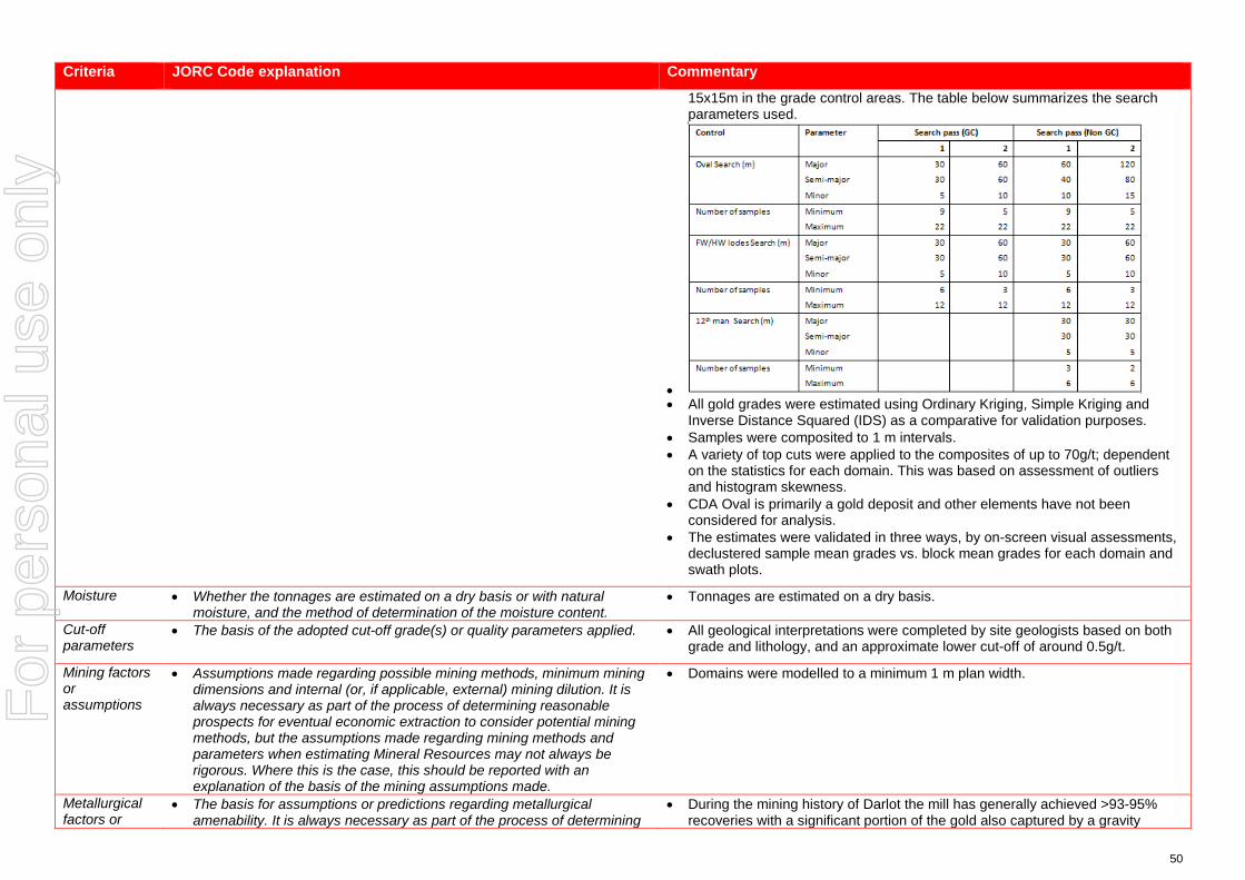
50
Criteria JORC Code explanation Commentary
15x15m in the grade control areas. The table below summarizes the search parameters used.
• • All gold grades were estimated using Ordinary Kriging, Simple Kriging and
Inverse Distance Squared (IDS) as a comparative for validation purposes. • Samples were composited to 1 m intervals. • A variety of top cuts were applied to the composites of up to 70g/t; dependent
on the statistics for each domain. This was based on assessment of outliers and histogram skewness.
• CDA Oval is primarily a gold deposit and other elements have not been considered for analysis.
• The estimates were validated in three ways, by on-screen visual assessments, declustered sample mean grades vs. block mean grades for each domain and swath plots.
Moisture • Whether the tonnages are estimated on a dry basis or with natural moisture, and the method of determination of the moisture content.
• Tonnages are estimated on a dry basis.
Cut-off parameters
• The basis of the adopted cut-off grade(s) or quality parameters applied. • All geological interpretations were completed by site geologists based on both grade and lithology, and an approximate lower cut-off of around 0.5g/t.
Mining factors or assumptions
• Assumptions made regarding possible mining methods, minimum mining dimensions and internal (or, if applicable, external) mining dilution. It is always necessary as part of the process of determining reasonable prospects for eventual economic extraction to consider potential mining methods, but the assumptions made regarding mining methods and parameters when estimating Mineral Resources may not always be rigorous. Where this is the case, this should be reported with an explanation of the basis of the mining assumptions made.
• Domains were modelled to a minimum 1 m plan width.
Metallurgical factors or
• The basis for assumptions or predictions regarding metallurgical amenability. It is always necessary as part of the process of determining
• During the mining history of Darlot the mill has generally achieved >93-95% recoveries with a significant portion of the gold also captured by a gravity
For
per
sona
l use
onl
y
51
Criteria JORC Code explanation Commentary
assumptions reasonable prospects for eventual economic extraction to consider potential metallurgical methods, but the assumptions regarding metallurgical treatment processes and parameters made when reporting Mineral Resources may not always be rigorous. Where this is the case, this should be reported with an explanation of the basis of the metallurgical assumptions made.
circuit. • A report from 2017 on metallurgical test-work done by ALS AMMTEC for the
CDA Oval lodes suggested that a recovery of 91% was achievable based on the sample composites provided by the Darlot Geology department.
Environmen-tal factors or assumptions
• Assumptions made regarding possible waste and process residue disposal options. It is always necessary as part of the process of determining reasonable prospects for eventual economic extraction to consider the potential environmental impacts of the mining and processing operation. While at this stage the determination of potential environmental impacts, particularly for a greenfields project, may not always be well advanced, the status of early consideration of these potential environmental impacts should be reported. Where these aspects have not been considered this should be reported with an explanation of the environmental assumptions made.
• Darlot has had an extensive mining history and as such has full infrastructure for the treatment of processing and mining residues.
• Darlot is certified as ISO14001 compliant for environmental management and is also certified for International Cyanide Management Code.
Bulk density • Whether assumed or determined. If assumed, the basis for the assumptions. If determined, the method used, whether wet or dry, the frequency of the measurements, the nature, size and representativeness of the samples.
• The bulk density for bulk material must have been measured by methods that adequately account for void spaces (vugs, porosity, etc), moisture and differences between rock and alteration zones within the deposit.
• Discuss assumptions for bulk density estimates used in the evaluation process of the different materials.
• A dry (in situ) bulk density of 2.90 t/m3 has been used for all lithologies. This value has been historically assigned for the Darlot project area.
• Data is available for bulk density determinations and is recorded in Red 5 Limited’s database, and was assessed by previous operators of the Darlot Gold Mine. The CP is satisfied that the value used is verifiable and typical given their knowledge and experience in similar deposits in the Eastern Goldfields of Western Australia.
• All the bulk density records that have been sighted were determined by the Archimedes method of immersion in water, with no wax coating required as porosity is not an issue in Darlot host rocks. These samples are considered representative of the lodes and waste zones.
Classification • The basis for the classification of the Mineral Resources into varying confidence categories.
• Whether appropriate account has been taken of all relevant factors (ie relative confidence in tonnage/grade estimations, reliability of input data, confidence in continuity of geology and metal values, quality, quantity and distribution of the data).
• Whether the result appropriately reflects the Competent Person’s view of the deposit.
• The Mineral Resource is classified as Indicated and Inferred. • The geological evidence for mineralisation occurrence and continuity was
observed in drill samples and significant underground workings on the CDA Oval lodes. For classification of Indicated; in the main steep lodes a drill spacing of <30 x 30 m was required, with <20 x 20 m for the flatter lodes. For classification of Inferred; < 60 x 60 m for steep lodes and < 40 x 40 m for the flatter lodes. Any blocks outside these parameters were unclassified. Drill sampling and analytical techniques for DD as well as face sampling are well documented by Red 5 Limited, as well as rigorous QAQC protocols and documentation to support an Indicated Resource Classification where geological confidence allows.
• The classification of the Mineral Resource took into account the geological understanding of the deposit, quality of the samples, quality and quantity of density data, drill hole spacing, and the quality of the block grade estimates. Geological understanding and quality of samples is sufficient to assume geological and grade continuity in the Indicated volumes.
• All relevant factors have been taken into account when determining the resource classification for CDA Oval deposit, and the results are deemed by
For
per
sona
l use
onl
y
52
Criteria JORC Code explanation Commentary
the CP to be fair and relevant.
Audits or reviews
• The results of any audits or reviews of Mineral Resource estimates. • The Mineral Resource Estimate was peer reviewed internally by Red 5 Senior Geologists.
Discussion of relative accuracy/ confidence
• Where appropriate a statement of the relative accuracy and confidence level in the Mineral Resource estimate using an approach or procedure deemed appropriate by the Competent Person. For example, the application of statistical or geostatistical procedures to quantify the relative accuracy of the resource within stated confidence limits, or, if such an approach is not deemed appropriate, a qualitative discussion of the factors that could affect the relative accuracy and confidence of the estimate.
• The statement should specify whether it relates to global or local estimates, and, if local, state the relevant tonnages, which should be relevant to technical and economic evaluation. Documentation should include assumptions made and the procedures used.
• These statements of relative accuracy and confidence of the estimate should be compared with production data, where available.
• The Mineral Resource estimate is considered a global resource for both Indicated and Inferred Resource estimations.
• The CP is comfortable that the ~1-2 years of mining and reconciliation data is deemed sufficient to verify the veracity of the estimate.
• Fully surveyed voids have been used to deplete the model of already mined material.
For
per
sona
l use
onl
y

53
JORC Code, 2012 Edition – Table 1 for the Burswood Resource – Part of the Darlot Deposit
Section 1 Sampling Techniques and Data (Criteria in this section apply to all succeeding sections.)
Criteria JORC Code explanation Commentary
Sampling techniques
• Nature and quality of sampling (eg cut channels, random chips, or specific specialised industry standard measurement tools appropriate to the minerals under investigation, such as down hole gamma sondes, or handheld XRF instruments, etc). These examples should not be taken as limiting the broad meaning of sampling.
• Include reference to measures taken to ensure sample representivity and the appropriate calibration of any measurement tools or systems used.
• Aspects of the determination of mineralisation that are Material to the Public Report.
• In cases where ‘industry standard’ work has been done this would be relatively simple (eg ‘reverse circulation drilling was used to obtain 1 m samples from which 3 kg was pulverised to produce a 30 g charge for fire assay’). In other cases more explanation may be required, such as where there is coarse gold that has inherent sampling problems. Unusual commodities or mineralisation types (eg submarine nodules) may warrant disclosure of detailed information.
• Reverse circulation (RC), diamond core (DD) drilling and face sampling (face) provided pulverised chips and competent lengths of core samples. Face sampling was converted to dummy drill holes and included in the database. Drill hole data supporting the Mineral Resource contains 328 unique drill hole IDs for a total sample length of 77,756.44 m. Sludge samples were excluded from the drill hole data files due to lack of quality assurance regarding sampling.
• A total of 311 Diamond drill holes (77,402.19 m), including 54 RCDD holes, 4 RC holes (254 m) and 13 face samples (100.25 m) support the Mineral Resource.
• Diamond core is predominantly NQ2 with some HQ and was cleaned, laid out, measured and logged in its entirety. Core is marked up with a maximum core length of 1 m, depending on core size. Some core is whole sampled (full core collection) when necessary, but most core is half cut core. Digital photographs are taken and stored for reference purposes. Where possible core is cut in half with one half only being submitted for analysis at the Laboratory, with the other half is stored in the core farm for reference.
• RC samples of 1 m drill length were passed through a rig mounted cyclone and collected in large plastic bags positioned beneath the cyclone. The action of the cyclone adequately homogenizes the sample collected in the bag. Representative 3 kg samples were collected in calico bags for dispatch to the analytical laboratory.
Drilling techniques
• Drill type (eg core, reverse circulation, open-hole hammer, rotary air blast, auger, Bangka, sonic, etc) and details (eg core diameter, triple or standard tube, depth of diamond tails, face-sampling bit or other type, whether core is oriented and if so, by what method, etc).
• The sample data for the Burswood area includes diamond drilling (DD), underground face samples (FACE), reverse circulation (RC) and RC holes with diamond core tails (RCDD). Only the diamond core samples from RCDD holes were used in the Burswood Mineral Resource. The data was collected during 2015/16 whilst targeting CDA Oval.
• Underground DDH is usually NQ2 or LTK60. • Underground face sampling was carried out by the geologists painting a
sample line orthogonal to the dip of the quartz veining, and sampled according to geological intervals. Samples were bagged and ticketed with unique sample IDs, and dispatched to the assay laboratory.
• RC drilling used a face sampling hammer.
Drill sample recovery
• Method of recording and assessing core and chip sample recoveries and results assessed.
• Measures taken to maximise sample recovery and ensure representative nature of the samples.
• Whether a relationship exists between sample recovery and grade and
• Drill sample recoveries are recorded for each sample number and stored in the Acquire database. Diamond core samples were geotechnically logged and sample recoveries calculated. Most drill samples penetrating mineralisation are diamond core.
• Core recovery factors for core drilling are generally very high typically in
For
per
sona
l use
onl
y
54
Criteria JORC Code explanation Commentary
whether sample bias may have occurred due to preferential loss/gain of fine/coarse material.
excess of 95% recovery. Some loss occurs locally when drilling through fault/shear zones. Face sampling, by its nature, can be a biased sampling method, relying on manual ‘picking’ of the face by either a geological hammer, or by a Jumbo scraping sample material off the face and collected by the mine geologist. Face sampling can be regarded as having 100% sample recovery, however the Competent Person is cognisant of sampling bias. The use of face samples in grade estimation is provided in Section 3.
• The supervising geologist monitored the diamond core recoveries and discussed any shortcoming with the driller. Recoveries are generally very good however.
• Where possible, RC percussion samples are recovered from the RC drill rig through the cyclone splitter, providing a 2-4 kg sample, which is submitted for assay.
Logging • Whether core and chip samples have been geologically and geotechnically logged to a level of detail to support appropriate Mineral Resource estimation, mining studies and metallurgical studies.
• Whether logging is qualitative or quantitative in nature. Core (or costean, channel, etc) photography.
• The total length and percentage of the relevant intersections logged.
• A geologist was present at all times during drilling and sampling. Geological logging protocols at the time of drilling were followed to ensure consistency in drill logs between the geological staff.
• Diamond core were logged for lithology, structure, stratigraphy, mineralisation, alteration, geophysical (magnetic properties) and geochemical properties (multi-element assays) and physical measurements (rock hardness, geotechnical RQD's, density, acid rock drainage (ARD)).
• The full sample lengths were logged. Core was photographed (mostly wet). • RC chips were logged for weathering, lithologies, mineralogy, colour and
grainsize. RC chip trays (with chips) were infrequently photographed.
Sub-sampling techniques and sample preparation
• If core, whether cut or sawn and whether quarter, half or all core taken. • If non-core, whether riffled, tube sampled, rotary split, etc and whether
sampled wet or dry. • For all sample types, the nature, quality and appropriateness of the
sample preparation technique. • Quality control procedures adopted for all sub-sampling stages to
maximise representivity of samples. • Measures taken to ensure that the sampling is representative of the in
situ material collected, including for instance results for field duplicate/second-half sampling.
• Whether sample sizes are appropriate to the grain size of the material being sampled.
• DD core sample lengths can be variable in a mineralized zone, though usually no larger than one-metre. This enables the capture of assay data for narrow structures and localized grade variations.
• Grade control drill holes are sampled as whole core. DD samples are taken according to a cut sheet compiled by the geologist. Half or full core samples are bagged in pre-numbered calico bags and submitted with a sample submission form.
• DD core is cut by a getoech field assistant. • RC drilling is logged and sampled on one-metre intervals using similar codes to
DD core. • The sampling protocols are considered appropriate for the style of
mineralisation. • A summary of the sample preparation process is as below:
o Oven dried at 105ºC. o Jaw crushed to -12 mm. o If sample >3kg, Boyd crusher to 3 mm, and riffle split to <3kg. o Pulverised in LM5. o 250-300 g pulp sample taken. o Remainder of pulp returned to calico sample bag.
• Quality Control (QC) samples are inserted at a rate of 1 in 20. All standards
For
per
sona
l use
onl
y

55
Criteria JORC Code explanation Commentary
used are Certified Reference Materials (CRM). The insertion of blanks is under the control of the geologist and CRMs are usually inserted one per batch.
• Sample sizes are considered appropriate to the grain size of the material being sampled.
Quality of assay data and laboratory tests
• The nature, quality and appropriateness of the assaying and laboratory procedures used and whether the technique is considered partial or total.
• For geophysical tools, spectrometers, handheld XRF instruments, etc, the parameters used in determining the analysis including instrument make and model, reading times, calibrations factors applied and their derivation, etc.
• Nature of quality control procedures adopted (eg standards, blanks, duplicates, external laboratory checks) and whether acceptable levels of accuracy (ie lack of bias) and precision have been established.
• Primary assaying of samples has been undertaken by ALS Kalgoorlie for considerable time. Documentation regarding more historical holes and their sample analyses are not well documented. Analysis is by 50g fire assay (FA) with Atomic Absorption Spectrometer (AAS) finish to 0.01 g/t detection limit. Given the occurrence of coarse gold, Screen Fire Assays (SFA) checks are periodically undertaken.
• The processes are considered total. • Previous operators employed a comprehensive QA/QC regime with CRMs,
blanks, quartz flush checks and grind checks routinely monitored. Coarse duplicates from crush residue, and pulp duplicates from pulp residues were regularly monitored to test the quality of sub sampling stages. Results are documented on a quarterly basis, with any failures or irregularities investigated and actions taken to correct the issue. Regular communications were had with ALS.
• Umpire analyses were undertaken at Independent Assay Laboratories (IAL) for selected samples comprising a 100 sample batch. Results show a reasonable correlation with the original samples, with differences largely attributable to nugget effects.
• Acceptable levels of accuracy and precision were established prior to accepting the sample data as support for the Mineral Resource estimate.
• The QAQC procedures and results show acceptable levels of accuracy and precision were established.
Verification of sampling and assaying
• The verification of significant intersections by either independent or alternative company personnel.
• The use of twinned holes. • Documentation of primary data, data entry procedures, data verification,
data storage (physical and electronic) protocols. • Discuss any adjustment to assay data.
• Intersections with significant Au grade are not unknown. Visible Au is sometimes observed. If core samples with significant intersections are logged then alternative geological personnel are likely to review and confirm the results.
• No twin drilling has occurred at Burswood. • All data at Darlot is stored in an SQL relational database format using acQuire
software. acQuire enables definition of tasks, permission management and database integrity. The SQL Server database is configured for optimal validation through constraints, library tables and triggers. Data that fails these rules on import is rejected and not ranked as a priority to be used for exports or any data applications.
• All exploration data control is managed centrally, from drill-hole planning to final assay, survey and geological capture. The majority of logging data (lithology, alteration, and structural characteristics of core and percussion chips) is captured directly either by manual or to customised digital logging tools with stringent validation and data entry constraints. Geologists load data in the acquire database where initial validation of the data occurs. The data are
For
per
sona
l use
onl
y

56
Criteria JORC Code explanation Commentary
uploaded into the database by the geologist after which ranking of the data happen based on multiple QAQC and validation rules.
• All assay data is uploaded into the database in a text format known as a sif. These files include detailed information about the batch, methods, units, detection limits and elements assayed. The file also includes all QC data in the sequence of analysis. The assay data is stored in a flattened format to ensure all required information is stored for each sample, and that multiple assay results are stored for each sample.
• Data validation is controlled via rules, library tables and triggers. Once all data for a drill-hole have been entered into the database, the geologist responsible for the drilling program validates each drill-hole. A standard validation trigger in the acquire database run queries against the data, which includes checks for incorrect collar locations, testing for overlapping, missing or incorrect down-hole surveys, and incorrect collar locations.
• A digital certified assay certificate in Adobe PDF format is backed up on the Darlot server on a regular schedule. A copy of the database also resides on the Red 5 back-up server in Perth.
• The database is secure and password protected by the Database Administrator to prevent accidental or malicious adjustment to data.
• No adjustments are made to the data.
Location of data points
• Accuracy and quality of surveys used to locate drill holes (collar and down-hole surveys), trenches, mine workings and other locations used in Mineral Resource estimation.
• Specification of the grid system used. • Quality and adequacy of topographic control.
• Collars are marked out pre-drilling and surveyed post-drilling by licensed surveyors. All recent DD holes were surveyed down the hole by Reflex non-magnetic multi shot gyro survey. Down hole surveys are routinely undertaken by the drilling contractor and verified by the mine geologist. Due to the relatively short depths of RC drilling (<100m) these holes are generally not surveyed. The 4 RC holes at Burswood are vertical. When RC is used as pre-collars to DDH tails, these are then surveyed using standard down hole gyro.
• Drill hole collars are located respective to the local mine grid and to the overall property in UTM MGA94-Zone51. Mine grid north is 44° west of north Australian Map Grid, and all mining Mineral Resource and Ore Reserve work is carried out in Mine Grid. Reduced Level (RL) for surface drilling is calculated by adding 1,000 m to surface elevation, while the underground RL is calculated by taking the surface RL minus the vertical depth to the point being referenced.
• Underground voids are surveyed by mine surveyors. The survey control on these voids is considered adequate to support the depletion of the Mineral Resource model.
Data spacing and distribution
• Data spacing for reporting of Exploration Results. • Whether the data spacing and distribution is sufficient to establish the
degree of geological and grade continuity appropriate for the Mineral Resource and Ore Reserve estimation procedure(s) and classifications applied.
• Whether sample compositing has been applied.
• Typical drill spacing in Burswood ranges up to 40x40m reducing to 20x20 in areas defined as Indicated.
• The Competent Person considers the data spacing to be sufficient to establish the degree of geological and grade continuity appropriate for the Mineral Resource classification categories adopted for Burswood.
For
per
sona
l use
onl
y
57
Criteria JORC Code explanation Commentary
• Samples were not composited prior to dispatch for analyses.
Orientation of data in relation to geological structure
• Whether the orientation of sampling achieves unbiased sampling of possible structures and the extent to which this is known, considering the deposit type.
• If the relationship between the drilling orientation and the orientation of key mineralised structures is considered to have introduced a sampling bias, this should be assessed and reported if material.
• Burswood was drilled by a combination of underground diamond holes, RC and face sampling, with each face sample trace assigned a drill hole collar ID. Underground drilling is confined to drill cuddies and the orientation of exploration holes is often oblique to the mineralisation. Face sampling traces are aligned orthogonal to the dip of the mineralisation, as exposed in the face, whenever possible. The surface holes (RC, RCDD) were orientated to penetrate the host unit as orthogonally as possible.
• Resultant sampling bias, particularly from face sampling, is usually retained in the drill database and any potential impact upon the Mineral Resource was not assessed. The Competent Person does not believe any potential impacts to be material in terms of grade interpolation.
Sample security
• The measures taken to ensure sample security. • Although security in not strongly enforced, Darlot is a remote site and the number of outside visitors is small. The deposit is known to contain visible gold and this renders the core susceptible to theft, however the risk of sample tampering is considered low.
• ALS Kalgoorlie organise transport companies to pick up bagged samples from a secured locality at the mine site. These are then transported to the laboratory facility for further preparation and assaying. All samples received by the laboratory are physically checked against the despatch order and Darlot is notified of any discrepancies prior to sample preparation commencing. No Red 5 personnel are involved in the preparation or analysis process.
Audits or reviews
• The results of any audits or reviews of sampling techniques and data. • A series of written standard procedures exists for sampling and core cutting at Darlot. Periodic routine visits to drill rigs and the core farm are carried out by project geologists and Senior Geologists / Superintendents to review core logging and sampling practices. There were no adverse findings, and any minor deficiencies were noted and staff notified, with remedial training if required.
For
per
sona
l use
onl
y
58
Section 2 Reporting of Exploration Results (Criteria listed in the preceding section also apply to this section.)
Criteria JORC Code explanation Commentary
Mineral tenement and land tenure status
• Type, reference name/number, location and ownership including agreements or material issues with third parties such as joint ventures, partnerships, overriding royalties, native title interests, historical sites, wilderness or national park and environmental settings.
• The security of the tenure held at the time of reporting along with any known impediments to obtaining a licence to operate in the area.
• Burswood is covered by mining lease M37/155 and held by Darlot Mining Company Limited. This lease covers 1,000Ha and was granted on 18/7/1988, renewed 17/7/2009 and to be renewed on 17/7/2030. Current rental has been paid ($17,600) and minimum annual expenditure of $100,000 is required, and is being met. There are no Joint Ventures over the tenure and no native title claims. There are no other agreements in place apart from a 2.5% royalty for all gold sold, payable to the Government of Western Australia.
Exploration done by other parties
• Acknowledgment and appraisal of exploration by other parties. • Burswood is part of the Darlot Gold Mine, which has a long history of gold mining and exploration. Alluvial gold was first mined in the area in 1894 with a consequent gold rush between 1895 and 1913. Total gold production from this time is unknown. Limited gold production occurred between 1935 and 1980.
• Modern exploration of Darlot commenced in the period in the 1970’s, with intensive exploration by Sundowner Minerals NL during 1986 to 1988. Darlot open pit mining commenced in 1988, and Sundowner was acquired by Plutonic Resources in 1992, who continued open cut mining through to 1995. Underground mining commenced in 1995 and has continued to the present day.
• To the end of October 2017, the Darlot Gold Mine has produced 17 Mt @ 4.8 g/t Au for 2.7 MOz produced.
• Burswood was discovered in 2015, however underground development of the deposit has not commenced.
• A total of 311 Diamond drill holes (77,402.19 m), including 54 RCDD holes, 4 RC holes (254 m) and 13 face samples (100.25 m) support the Mineral Resource.
• 3D seismic surveys were carried out in late 2016 to provide geophysical data in support of planned exploration programs down dip, although the seismic surveys do not support Burswood as much as they do Centenary, which the surveys were focusing upon.
Geology • Deposit type, geological setting and style of mineralisation. • The Darlot lodes are considered to be part of an Archean hydrothermal fault-vein deposit with many similar characteristics with other deposits within the Yilgarn Craton, namely host rock type and nature of hydrothermal alteration; however, it is atypical in being relatively flat-lying rather than steeply dipping. Felsic porphyries and lamprophyre intrusions are encountered throughout the deposit. The major host for gold mineralisation is the Mount Pickering Dolerite.
• The Burswood deposit is located approximately 1 km east of the Darlot open pit and has been defined between surface and 650 m below the surface.
• Gold mineralisation is associated with quartz veins and alteration haloes controlled by major D2 and D3 structures or secondary splays and cross linking structures. The quartz veins are hosted mainly by magnetic dolerite and magnetic quartz dolerite rock types and, to a lesser extent, by non-magnetic
For
per
sona
l use
onl
y
59
Criteria JORC Code explanation Commentary
dolerite and felsic volcano-sedimentary rock types. Lamprophyre intrusions are present in the area with a variety of orientations. In most cases the lamprophyres are thought to be pre-mineralisation but are an un-favorable host rock for mineralisation and in most cases are barren.
• The Burswood mineralisation is associated the Burswood fault itself, and proximal vein assemblages. The Burswood fault dips approximately 55 degrees to the NW. It is structurally controlled by the Burswood fault and geochemically / rheologically within the magnetic dolerite unit. Gold mineralisation appears to be intimately related to albite, silica and sericite alteration and sulphide (mainly pyrite) intensity surrounding quartz vein assemblages. Visible gold has been observed in core, however does not appear to be common. It is thought to be analogous with the Walters in Centenary. The ~2-3cm wide sub-horizontal Darcent Veins are comparable to the Boon West Mineralisation in the Centenary, and sit in-between the Burswood, Moses and Darlot thrust structures. The Lower Pedersen lode is a depth extension of the Pedersen lode seen in the Pedersen area and dips at around 20°to the SE.
• The Burswood structure is present in both the Eastern and Western magnetic dolerite unit. As with most mineralisation with Centenary, gold mineralisation drastically drops off outside the magnetic dolerite. To the North of the Burswood is a NW/SE (DMG) trending lamprophyre unit, interpreted to have intruded through a pre-existing structure, and is barren of any mineralisation. The Burswood model is accurate within fresh rock although the structure does extend to the surface.
Drill hole Information
• A summary of all information material to the understanding of the exploration results including a tabulation of the following information for all Material drill holes: o easting and northing of the drill hole collar o elevation or RL (Reduced Level – elevation above sea level in metres)
of the drill hole collar o dip and azimuth of the hole o down hole length and interception depth o hole length.
• If the exclusion of this information is justified on the basis that the information is not Material and this exclusion does not detract from the understanding of the report, the Competent Person should clearly explain why this is the case.
• Drill hole information from Darlot drill programs, predominantly diamond core and face sampling, with minor number of RC samples, were used to support the Mineral Resource estimate. The locations of drill samples, and the geological logs of these samples were used to build the geological model, and with the sample analyses, support the Mineral Resource estimate.
Data aggregation methods
• In reporting Exploration Results, weighting averaging techniques, maximum and/or minimum grade truncations (eg cutting of high grades) and cut-off grades are usually Material and should be stated.
• Where aggregate intercepts incorporate short lengths of high grade results and longer lengths of low grade results, the procedure used for such aggregation should be stated and some typical examples of such aggregations should be shown in detail.
• The assumptions used for any reporting of metal equivalent values
• Exploration results are not reported here, with most drill holes and face samples used to support the Mineral Resource estimate. Sludge samples are recorded in the drill hole database but were not used in the Mineral Resource estimate due insufficient reliability of sampling methods.
For
per
sona
l use
onl
y
60
Criteria JORC Code explanation Commentary
should be clearly stated. Relationship between mineralisation widths and intercept lengths
• These relationships are particularly important in the reporting of Exploration Results.
• If the geometry of the mineralisation with respect to the drill hole angle is known, its nature should be reported.
• If it is not known and only the down hole lengths are reported, there should be a clear statement to this effect (eg ‘down hole length, true width not known’).
• The Burswood mineralisation is associated the Burswood fault, and proximal vein assemblages. The Burswood fault dips approximately 55 degrees to the NW. The Lower Pedersen lode is a depth extension of the Pedersen lode seen in the Pedersen area and dips at around 20°to the SE.
• Drillholes are angled to drill as close to perpendicular to mineralisation as possible, although this is difficult when drilling from underground locations, targeting lode positions along strike from the drill cuddies.
• Intercepts reported are downhole length, and true width can generally be calculated because the dip of the lode is known from structural measurements of DD core.
Diagrams • Appropriate maps and sections (with scales) and tabulations of intercepts should be included for any significant discovery being reported These should include, but not be limited to a plan view of drill hole collar locations and appropriate sectional views.
• Isometric view representing the Darlot deposit (including the Burswood Resource) is shown in announcement.
Balanced reporting
• Where comprehensive reporting of all Exploration Results is not practicable, representative reporting of both low and high grades and/or widths should be practiced to avoid misleading reporting of Exploration Results.
• Exploration results are not reported here, with all drill holes used to support the Mineral Resource estimate.
Other substantive exploration data
• Other exploration data, if meaningful and material, should be reported including (but not limited to): geological observations; geophysical survey results; geochemical survey results; bulk samples – size and method of treatment; metallurgical test results; bulk density, groundwater, geotechnical and rock characteristics; potential deleterious or contaminating substances.
• Burswood is part of the Darlot Gold Mine, and the lodes were geologically interpreted primarily from DD geological logs. The geological logs were the foundation for the interpretation of the geological models.
• No metallurgical testwork has been carried out to date on Burswood ore samples. Testwork is planned.
• No bulk density testwork has been carried out to date on Burswood samples. Burswood is similar in geological style of mineralisation to Centenary (analogous to the Walters Lode in Centenary), and is assumed to have a similar density to Centenary.
Further work • The nature and scale of planned further work (eg tests for lateral extensions or depth extensions or large-scale step-out drilling).
• Diagrams clearly highlighting the areas of possible extensions, including the main geological interpretations and future drilling areas, provided this information is not commercially sensitive.
• Burswood is open along strike, with potential for additional gold mineralisation in these directions.
• Plans are currently being formulated for exploration drilling to test these targets, including geological controls on mineralisation and to gather samples for metallurgical testwork and bulk density testwork.
For
per
sona
l use
onl
y
61
Section 3 Estimation and Reporting of Mineral Resources (Criteria listed in section 1, and where relevant in section 2, also apply to this section.)
Criteria JORC Code explanation Commentary
Database integrity
• Measures taken to ensure that data has not been corrupted by, for example, transcription or keying errors, between its initial collection and its use for Mineral Resource estimation purposes.
• Data validation procedures used.
• Data is entered directly into the data capture system in the field, and reviewed by a geologist before being imported to the main database. Geological Logging at Darlot is collected by geologists and entered directly into an Acquire Database on a laptop computer. Logging is regularly checked by a senior company geologist to ensure the veracity and consistency of the data.
• Logs cannot be finalised if key fields are missing, nor can codes not existing in the library be entered, ensuring continuity of data, and reducing data entry and transcription errors.
• Once in the main database, only the database administrators can edit or change data, and all changes are logged by the system.
Site visits • Comment on any site visits undertaken by the Competent Person and the outcome of those visits.
• If no site visits have been undertaken indicate why this is the case.
• The Competent Person(s) (CP) are based on site at Darlot and are familiar with the geological setting of the deposit, sampling protocols, quality control and quality assurance (QA/QC) of sample data, resource modelling procedures, current site procedures and policies, and are confident that all data collected is verifiable and has been collected in line with industry best practices to support a Mineral Resource Estimate.
Geological interpretation
• Confidence in (or conversely, the uncertainty of ) the geological interpretation of the mineral deposit.
• Nature of the data used and of any assumptions made. • The effect, if any, of alternative interpretations on Mineral Resource
estimation. • The use of geology in guiding and controlling Mineral Resource
estimation. • The factors affecting continuity both of grade and geology.
• Gold mineralisation is associated with quartz veins and alteration haloes controlled by major D2 and D3 structures or secondary splays and cross linking structures. The quartz veins are hosted mainly by magnetic dolerite and magnetic quartz dolerite rock types and, to a lesser extent, by non-magnetic dolerite and felsic volcano-sedimentary rock types. Lamprophyre intrusions are present in the area with a variety of orientations. In most cases the lamprophyres are thought to be pre-mineralisation but are an un-favorable host rock for mineralisation and in most cases are barren.
• The Burswood mineralisation is associated the Burswood fault itself, and proximal vein assemblages. The Burswood fault dips approximately 55 degrees to the NW. It is structurally controlled by the Burswood fault and geochemically / rheologically within the magnetic dolerite unit. Gold mineralisation appears to be intimately related to albite, silica and sericite alteration and sulphide (mainly pyrite) intensity surrounding quartz vein assemblages. Visible gold has been observed in core, however does not appear to be common. It is thought to be analogous with the Walters in Centenary. The ~2-3cm wide sub-horizontal Darcent Veins are comparable to the Boon West Mineralisation in the Centenary, and sit in-between the Burswood, Moses and Darlot thrust structures. The Lower Pedersen lode is a depth extension of the Pedersen lode seen in the Pedersen area and dips at around 20°to the SE.
• The Burswood structure is present in both the Eastern and Western magnetic dolerite unit. As with most mineralisation with Centenary, gold mineralisation drastically drops off outside the magnetic dolerite. To the North of the Burswood is a NW/SE (DMG) trending lamprophyre unit, interpreted to have
For
per
sona
l use
onl
y
62
Criteria JORC Code explanation Commentary
intruded through a pre-existing structure, and is barren of any mineralisation. The Burswood model is accurate within fresh rock although the structure does extend to the surface.
• The sample data for the Burswood includes diamond drilling (DD) and reverse circulation (RC) with DD tail. Underground face samples taken by mine geologists were also included. Some holes were excluded due to erroneous collar and down-hole surveys and a default grade of 0.005g/t was assigned where the gold grade was absent. The interpretations supporting the geological models are predominantly based upon drillhole samples.
• All geological interpretations for the Burswood are prepared in Darlot Mine Grid.
• The Burswood deposit overlaps to a certain extent with the Pedersen area, and is itself analogous with the Walters lode in Centenary; hence alternative interpretations have not been considered as the geological controls are generally well understood. The interpretation is also well supported by numerous drillhole intercepts.
• The Burswood Deposit is sub-divided into four mineralised domains based on geology and structure, with the steeper fault hosted domains such as the Burswood and Moses separated from the Darcent veins and the Lower Pedersen lodes. Those domains with similar characteristics were grouped geo-statistically.
• The site geologists prepared the interpretations of the mineralised lodes within these three domains and the 37 lodes are modeled as individual wireframes.
• The grade in the lodes is controlled by both structure and host lithology, in that typically the best grades are hosted by the Magnetic Dolerite and Felsic intrusions, with comparatively lesser grades observed in the other host rocks such as the non-magnetic dolerite. Consequently host lithology for lodes was a key factor considered for the estimate.
Dimensions • The extent and variability of the Mineral Resource expressed as length (along strike or otherwise), plan width, and depth below surface to the upper and lower limits of the Mineral Resource.
• The Burswood deposit has an overall strike length of about 900 m and a width of about 600 m and extends from the natural surface to a depth of approximately 650 m.
Estimation and modelling techniques
• The nature and appropriateness of the estimation technique(s) applied and key assumptions, including treatment of extreme grade values, domaining, interpolation parameters and maximum distance of extrapolation from data points. If a computer assisted estimation method was chosen include a description of computer software and parameters used.
• The availability of check estimates, previous estimates and/or mine production records and whether the Mineral Resource estimate takes appropriate account of such data.
• The assumptions made regarding recovery of by-products. • Estimation of deleterious elements or other non-grade variables of
economic significance (eg sulphur for acid mine drainage characterisation).
• As previously noted, the Mineral Resource estimate has been divided into four (4) domains for the purpose of resource estimation. The model was constructed with Leapfrog software.
• The 37 wireframes mentioned above were imported directly into Vulcan for grade estimation and resource reporting.
• Vulcan was used for block modelling, grade interpolation, and Mineral Resource classification and reporting. Snowden Supervisor was used for geostatistical analyses. The Au domain interpretations were based upon both geology and grade.
• Significant amounts of lamprophyre which are generally barren cross-cut some of the lodes, some of the larger ones were wire-framed by the site geologists. These areas are flagged as waste in the final model.
• The Burswood lodes are mostly yet to be mined so no mining data is available.
For
per
sona
l use
onl
y
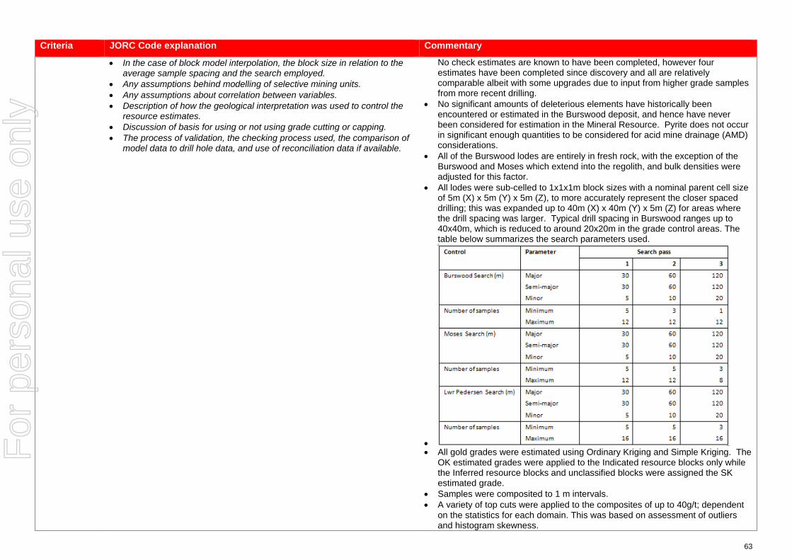
63
Criteria JORC Code explanation Commentary
• In the case of block model interpolation, the block size in relation to the average sample spacing and the search employed.
• Any assumptions behind modelling of selective mining units. • Any assumptions about correlation between variables. • Description of how the geological interpretation was used to control the
resource estimates. • Discussion of basis for using or not using grade cutting or capping. • The process of validation, the checking process used, the comparison of
model data to drill hole data, and use of reconciliation data if available.
No check estimates are known to have been completed, however four estimates have been completed since discovery and all are relatively comparable albeit with some upgrades due to input from higher grade samples from more recent drilling.
• No significant amounts of deleterious elements have historically been encountered or estimated in the Burswood deposit, and hence have never been considered for estimation in the Mineral Resource. Pyrite does not occur in significant enough quantities to be considered for acid mine drainage (AMD) considerations.
• All of the Burswood lodes are entirely in fresh rock, with the exception of the Burswood and Moses which extend into the regolith, and bulk densities were adjusted for this factor.
• All lodes were sub-celled to 1x1x1m block sizes with a nominal parent cell size of 5m (X) x 5m (Y) x 5m (Z), to more accurately represent the closer spaced drilling; this was expanded up to 40m (X) x 40m (Y) x 5m (Z) for areas where the drill spacing was larger. Typical drill spacing in Burswood ranges up to 40x40m, which is reduced to around 20x20m in the grade control areas. The table below summarizes the search parameters used.
• • All gold grades were estimated using Ordinary Kriging and Simple Kriging. The
OK estimated grades were applied to the Indicated resource blocks only while the Inferred resource blocks and unclassified blocks were assigned the SK estimated grade.
• Samples were composited to 1 m intervals. • A variety of top cuts were applied to the composites of up to 40g/t; dependent
on the statistics for each domain. This was based on assessment of outliers and histogram skewness.
For
per
sona
l use
onl
y
64
Criteria JORC Code explanation Commentary
• Burswood is primarily a gold deposit and other elements have not been considered for analysis.
• The estimates were validated in three ways, by on-screen visual assessments, declustered sample mean grades vs. block mean grades for each domain and swath plots.
Moisture • Whether the tonnages are estimated on a dry basis or with natural moisture, and the method of determination of the moisture content.
• Tonnages are estimated on a dry basis.
Cut-off parameters
• The basis of the adopted cut-off grade(s) or quality parameters applied. • All geological interpretations were completed in Leapfrog by site geologists based on both grade and lithology, and an approximate lower cut-off of around 0.5g/t.
Mining factors or assumptions
• Assumptions made regarding possible mining methods, minimum mining dimensions and internal (or, if applicable, external) mining dilution. It is always necessary as part of the process of determining reasonable prospects for eventual economic extraction to consider potential mining methods, but the assumptions made regarding mining methods and parameters when estimating Mineral Resources may not always be rigorous. Where this is the case, this should be reported with an explanation of the basis of the mining assumptions made.
• Domains were modelled to a minimum 1 m plan width.
Metallurgical factors or assumptions
• The basis for assumptions or predictions regarding metallurgical amenability. It is always necessary as part of the process of determining reasonable prospects for eventual economic extraction to consider potential metallurgical methods, but the assumptions regarding metallurgical treatment processes and parameters made when reporting Mineral Resources may not always be rigorous. Where this is the case, this should be reported with an explanation of the basis of the metallurgical assumptions made.
• Metallurgical test work is planned but is yet to be carried out on the Burswood.
Environmen-tal factors or assumptions
• Assumptions made regarding possible waste and process residue disposal options. It is always necessary as part of the process of determining reasonable prospects for eventual economic extraction to consider the potential environmental impacts of the mining and processing operation. While at this stage the determination of potential environmental impacts, particularly for a greenfields project, may not always be well advanced, the status of early consideration of these potential environmental impacts should be reported. Where these aspects have not been considered this should be reported with an explanation of the environmental assumptions made.
• Darlot has had an extensive mining history and as such has full infrastructure for the treatment of processing and mining residues.
• Darlot is certified as ISO14001 compliant for environmental management and is also certified for International Cyanide Management Code.
Bulk density • Whether assumed or determined. If assumed, the basis for the assumptions. If determined, the method used, whether wet or dry, the frequency of the measurements, the nature, size and representativeness of the samples.
• The bulk density for bulk material must have been measured by methods that adequately account for void spaces (vugs, porosity, etc), moisture and differences between rock and alteration zones within the deposit.
• Discuss assumptions for bulk density estimates used in the evaluation
• A dry (in situ) bulk density of 2.90 t/m3 has been used for all lithologies. This value has been historically assigned for the Darlot project area.
• Data is available for bulk density determinations and is recorded in Red 5 Limited’s database, and was assessed by previous operators of the Darlot Gold Mine. The CP is satisfied that the value used is verifiable and typical given their knowledge and experience in similar deposits in the Eastern Goldfields of Western Australia.
• No Density test work has been carried out on Burswood as yet however it is
For
per
sona
l use
onl
y

65
Criteria JORC Code explanation Commentary
process of the different materials. analogous to the Walters in Centenary and should therefore have a similar bulk density. Density test work will be carried out when drilling of this deposit resumes.
Classification • The basis for the classification of the Mineral Resources into varying confidence categories.
• Whether appropriate account has been taken of all relevant factors (ie relative confidence in tonnage/grade estimations, reliability of input data, confidence in continuity of geology and metal values, quality, quantity and distribution of the data).
• Whether the result appropriately reflects the Competent Person’s view of the deposit.
• The Mineral Resource is classified as Indicated and Inferred. • The geological evidence for mineralisation occurrence and continuity was
observed in drill samples and significant underground workings on the Burswood lodes. For classification of Indicated; a drill spacing of <30 x 30 m was required. For classification of Inferred; < 60 x 60 m. Any blocks outside these parameters were unclassified. Drill sampling and analytical techniques for DD and RC drilling as well as face sampling are well documented by Red 5 Limited, as well as rigorous QAQC protocols and documentation to support an Indicated Resource Classification where geological confidence allows.
• The classification of the Mineral Resource took into account the geological understanding of the deposit, quality of the samples, quality and quantity of density data, drill hole spacing, and the quality of the block grade estimates. Geological understanding and quality of samples is sufficient to assume geological and grade continuity in the Indicated volumes.
• All relevant factors have been taken into account when determining the resource classification for Burswood deposit, and the results are deemed by the CP to be fair and relevant.
Audits or reviews
• The results of any audits or reviews of Mineral Resource estimates. • The Mineral Resource Estimate was peer reviewed internally by Goldfields Australia, who were the previous owners of the Darlot Gold Mine.
Discussion of relative accuracy/ confidence
• Where appropriate a statement of the relative accuracy and confidence level in the Mineral Resource estimate using an approach or procedure deemed appropriate by the Competent Person. For example, the application of statistical or geostatistical procedures to quantify the relative accuracy of the resource within stated confidence limits, or, if such an approach is not deemed appropriate, a qualitative discussion of the factors that could affect the relative accuracy and confidence of the estimate.
• The statement should specify whether it relates to global or local estimates, and, if local, state the relevant tonnages, which should be relevant to technical and economic evaluation. Documentation should include assumptions made and the procedures used.
• These statements of relative accuracy and confidence of the estimate should be compared with production data, where available.
• The Mineral Resource estimate is considered a global resource for both Indicated and Inferred Resource estimations.
• The CP is comfortable that the diamond drilling and subsequent sampling protocols and procedures that the estimate is based on is sufficiently accurate to support this Mineral Resource estimate.
• Fully surveyed voids have been used to deplete the model of already mined material.
For
per
sona
l use
onl
y

1
JORC Code, 2012 Edition – Table 1 for the Reserves covering the Centenary Combined, Pederson, Lord South Lower, CDA Oval and Burswood – Part of the Darlot Deposit
Section 4 Estimation and Reporting of Ore Reserves (Criteria listed in section 1, and where relevant in sections 2 and 3, also apply to this section.)
Criteria JORC Code explanation Commentary
Mineral Resource estimate for conversion to Ore Reserves
• Description of the Mineral Resource estimate used as a basis for the conversion to an Ore Reserve.
• Clear statement as to whether the Mineral Resources are reported additional to, or inclusive of, the Ore Reserves.
• The mineral resource estimate covers the Centenary Combined, Pederson, Lord South Lower, CDA Oval and Burswood – Part of the Darlot Deposit. The mineral resource estimates were completed on the individual models from which the reserve estimate was completed using data on actual mining and processing costs at Darlot
• The Mineral Resources are reported inclusive of the Ore Reserve
Site visits • Comment on any site visits undertaken by the Competent Person and the outcome of those visits.
• If no site visits have been undertaken indicate why this is the case.
• The Competent Person together with other Red 5 Senior Technical Staff including Geologists, Mining Engineers and contract Geotechnical Engineer all work full time at the Darlot Gold Mine
Study status • The type and level of study undertaken to enable Mineral Resources to be converted to Ore
• Reserves. • The Code requires that a study to at least Pre-Feasibility Study level has
been undertaken to convert Mineral Resources to Ore Reserves. Such studies will have been carried out and will have determined a mine plan that is technically achievable and economically viable, and that material Modifying Factors have been considered.
• The Darlot Underground Gold Mine has been operated continuously since 1995 with operating parameters well understood
• A Pre-Feasibility Study standard study was undertaken to using actual Darlot Mining, Processing and Administration costs to assess the economic viability of mining extensions to existing work areas
• Material Modifying Factors have been assessed
Cut-off parameters
• The basis of the cut-off grade(s) or quality parameters applied. • Break even cut off of 2.3 g/t applied. Based actual mining and processing costs at Darlot and assumes the process plant will be operated at full capacity with the addition of additional ore from the Red 5 owned King of the Hills Mine.
Mining factors or assumptions
• The method and assumptions used as reported in the Pre-Feasibility or Feasibility Study to convert the Mineral Resource to an Ore Reserve (i.e. either by application of appropriate factors by optimisation or by preliminary or detailed design).
• The choice, nature and appropriateness of the selected mining method(s) and other mining parameters including associated design issues such as pre-strip, access, etc.
• The assumptions made regarding geotechnical parameters (eg pit slopes, stope sizes, etc), grade control and pre-production drilling.
• The major assumptions made and Mineral Resource model used for pit and stope optimisation (if appropriate).
• The mining dilution factors used. • The mining recovery factors used. • Any minimum mining widths used. • The manner in which Inferred Mineral Resources are utilised in mining
• Indicated Resources were converted to Probable Ore Reserves subject to mine design physicals and an economic evaluation.
• Selected mining method deemed appropriate based on geotechnical advice and previous experience and history at Darlot.
• Assumptions have been based on actual mining performance at Darlot with Geotechnical Assessments undertaken over the years to develop a comprehensive ground support and reinforcement regime for conditions encountered at Darlot.
• Stopes have been designed based on an economic cut-off of 2.3 g/t. • Mining dilution of 15 to 20% has been used. • Mining recovery factor of 95% is applied. • Minimum stope widths of 2.0m for Longhole stopes • Designed stopes with greater than 50% inferred blocks are excluded from the
reported reserve. • Darlot is an operating underground mine and as such all the required
For
per
sona
l use
onl
y

2
Criteria JORC Code explanation Commentary
studies and the sensitivity of the outcome to their inclusion. • The infrastructure requirements of the selected mining methods.
infrastructure is in place and operational. Minor Capital Development will be required to extract all of the ore reserve.
Metallurgical factors or assumptions
• The metallurgical process proposed and the appropriateness of that process to the style of mineralisation.
• Whether the metallurgical process is well-tested technology or novel in nature.
• The nature, amount and representativeness of metallurgical test work undertaken, the nature of the metallurgical domaining applied and the corresponding metallurgical recovery factors applied.
• Any assumptions or allowances made for deleterious elements. • The existence of any bulk sample or pilot scale test work and the degree
to which such samples are considered representative of the orebody as a whole.
• For minerals that are defined by a specification, has the ore reserve estimation been based on the appropriate mineralogy to meet the specifications?
• The ore reserve will be processed at the Darlot processing plant which utilizes a CIL (Carbon in Leach) circuit for the extraction of gold. Reserves are based on historical plant data and historical recoveries. Recoveries of 94% have been used.
• The Darlot processing plant is currently operating and is a conventional design. • No additional testwork was undertaken as all the ore reserve is contained
within previously mined orebodies which are currently being processed on site. • Recoveries through the Darlot processing plant have averaged 94%, • There have been no deleterious elements identified while processing Darlot
ore. • Recovery based on actual historical performance. • Not applicable
Environmen-tal
• The status of studies of potential environmental impacts of the mining and processing operation. Details of waste rock characterisation and the consideration of potential sites, status of design options considered and, where applicable, the status of approvals for process residue storage and waste dumps should be reported.
• The Darlot Gold Mine is currently compliant with all legal and regulatory requirements. Mine waste is currently stored within the open pit or used to backfill completed stopes. All government permits and licenses and statutory approvals are in place for this operating mine.
Infrastructure • The existence of appropriate infrastructure: availability of land for plant development, power, water, transportation (particularly for bulk commodities), labour, accommodation; or the ease with which the infrastructure can be provided, or accessed.
• Darlot is a well-established gold mine and has all the required infrastructure in place including a 400 person accommodation village, process plant, offices and workshops, airstrip, water supply and road access.
Costs • The derivation of, or assumptions made, regarding projected capital costs in the study.
• The methodology used to estimate operating costs. • Allowances made for the content of deleterious elements. • The derivation of assumptions made of metal or commodity price(s), for
the principal minerals and co- products. • The source of exchange rates used in the study. • Derivation of transportation charges. • The basis for forecasting or source of treatment and refining charges,
penalties for failure to meet specification, etc. • The allowances made for royalties payable, both Government and
private.
• All capital infrastructure is in place- minimal capital is required for ongoing extraction of the ore reserves. Provisions made for ongoing sustaining capital based on historical performance.
• Operating costs for Processing, Mining, Geology and Administration costs have been estimated as a cost per ore tonne based on actual site costs. An assumption has been made that the process plant will also treat ore from the King of the Hills Gold Mine reducing the fixed cost per tonne for processing and administration.
• There have been no deleterious elements identified while processing Darlot ore.
• Revenue was based on an AUD gold price of $1,650/oz, based on the gold price at the time the reserves were being calculated and used for the Darlot 2018 Budget.
• Perth Mint contractual transport and refining charges built into the cost model • Government royalties built into the cost model.
For
per
sona
l use
onl
y

3
Criteria JORC Code explanation Commentary
Revenue factors
• The derivation of, or assumptions made regarding revenue factors including head grade, metal or commodity price(s) exchange rates, transportation and treatment charges, penalties, net smelter returns, etc.
• The derivation of assumptions made of metal or commodity price(s), for the principal metals, minerals and co-products.
• Revenue was based on an AUD gold price of $1,650/oz, based on the gold price at the time the reserves were being calculated and used for the Darlot 2018 Budget.
• Perth Mint contractual transport and refining charges built into the cost model
Market assessment
• The demand, supply and stock situation for the particular commodity, consumption trends and factors likely to affect supply and demand into the future.
• A customer and competitor analysis along with the identification of likely market windows for the product.
• Price and volume forecasts and the basis for these forecasts. • For industrial minerals the customer specification, testing and acceptance
requirements prior to a supply contract.
• Gold bullion is sold direct at market prices to the Perth Mint with no hedges in place. Historical gold price and forward looking estimates have been used for the gold price.
• Not applicable
• Not applicable • Not applicable
Economic • The inputs to the economic analysis to produce the net present value (NPV) in the study, the source and confidence of these economic inputs including estimated inflation, discount rate, etc.
• NPV ranges and sensitivity to variations in the significant assumptions and inputs.
• All costs assumptions are made based on historical performance from Darlot and current economic forecast seen as representative of current market conditions.
• Sensitivity to gold price, grade, recovery and costs were evaluated.
Social • The status of agreements with key stakeholders and matters leading to social licence to operate.
• Agreements are in place and are current with all key stakeholders
Other • To the extent relevant, the impact of the following on the project and/or on the estimation and classification of the Ore Reserves:
• Any identified material naturally occurring risks. • The status of material legal agreements and marketing arrangements. • The status of governmental agreements and approvals critical to the
viability of the project, such as mineral tenement status, and government and statutory approvals. There must be reasonable grounds to expect that all necessary Government approvals will be received within the timeframes anticipated in the Pre-Feasibility or Feasibility study. Highlight and discuss the materiality of any unresolved matter that is dependent on a third party on which extraction of the reserve is contingent.
• None identified
• None identified • Darlot is currently compliant with all legal and regulatory requirements. All
government permits and licenses and statutory approvals are in place
Classification • The basis for the classification of the Ore Reserves into varying confidence categories.
• Whether the result appropriately reflects the Competent Person’s view of the deposit.
• The proportion of Probable Ore Reserves that have been derived from Measured Mineral Resources (if any).
• All Ore Reserves include Proved (if any) and Probable classifications.
• The results accurately reflect the Competent Persons view of the deposit. • None.
Audits or reviews
• The results of any audits or reviews of Ore Reserve estimates. • There have been no external reviews of this Ore reserve estimate.
Discussion of relative accuracy/ confidence
• Where appropriate a statement of the relative accuracy and confidence level in the Ore Reserve estimate using an approach or procedure deemed appropriate by the Competent Person. For example, the application of statistical or geostatistical procedures to quantify the relative accuracy of the reserve within stated confidence limits, or, if such
• This ore reserve statement has been prepared in accordance with the guidelines of the 2012 JORC Code. The resource estimates used to estimate the ore reserves are reliant on block models which were estimated using drill hole data drilled to a density required for classification of an indicated resource.
• Mining dilution and ore recoveries were based on information from historical
For
per
sona
l use
onl
y

4
Criteria JORC Code explanation Commentary
an approach is not deemed appropriate, a qualitative discussion of the factors which could affect the relative accuracy and confidence of the estimate.
• The statement should specify whether it relates to global or local estimates, and, if local, state the relevant tonnages, which should be relevant to technical and economic evaluation. Documentation should include assumptions made and the procedures used.
• Accuracy and confidence discussions should extend to specific discussions of any applied Modifying Factors that may have a material impact on Ore Reserve viability, or for which there are remaining areas of uncertainty at the current study stage.
• It is recognised that this may not be possible or appropriate in all circumstances. These statements of relative accuracy and confidence of the estimate should be compared with production data, where available.
mining operations at Darlot • Reconciliation for the past 2 years of underground production at Darlot
indicates that 20% more ore tonnes were mined as compared to the design, at a similar grade and that the gold produced from the process plant indicated that the grade control grades should have been 10% higher.
For
per
sona
l use
onl
y