magnitude–frequency relationships of debris flows — a · pdf...
TRANSCRIPT

Geomorphology 116 (2010) 67–76
Contents lists available at ScienceDirect
Geomorphology
j ourna l homepage: www.e lsev ie r.com/ locate /geomorph
Magnitude–frequency relationships of debris flows — A case study based on fieldsurveys and tree-ring records
Markus Stoffel ⁎Laboratory of Dendrogeomorphology (dendrolab.ch), Institute of Geological Sciences, University of Berne, 3012 Berne, SwitzerlandClimatic Change and Climate Impacts, Chair for Environmental Sciences, University of Geneva, 1227 Carouge-Geneva, Switzerland
⁎ Laboratory of Dendrogeomorphology (dendrolab.ch),University of Berne, 3012 Berne, Switzerland. Tel./fax: +41
E-mail address: [email protected].
0169-555X/$ – see front matter © 2009 Elsevier B.V. Adoi:10.1016/j.geomorph.2009.10.009
a b s t r a c t
a r t i c l e i n f oArticle history:Received 30 July 2009Received in revised form 14 October 2009Accepted 15 October 2009Available online 24 October 2009
Keywords:Debris flowsTree-ring analysisDendrogeomorphologyDepositsSedimentTriggering eventsPermafrostClimate changeSwiss Alps
Debris-flow activity in a watershed is usually defined in terms of magnitude and frequency. Whilemagnitude–frequency (M–F) relations have long formed the basis for risk assessment and engineeringdesign in hydrology and fluvial hydraulics, only fragmentary and insufficiently specified data for debris flowsexists. This paper reconstructs M–F relationships of 62 debris flows for an aggradational cone of a small(<5 km2), high elevation watershed in the Swiss Alps since A.D. 1863. The frequency of debris flows isobtained from tree-ring records. The magnitude of individual events is given as S, M, L, XL, and derived fromvolumetric data of deposits, grain size distributions of boulders, and a series of surrogates (snout elevations,tree survival, lateral spread of surges). Class S and M debris flows (<5×10³m3) encompass a typical size ofevents and have mean recurrence intervals of 5.4 (SD: 3.2) and 7.4 years (SD: 6.7), respectively. Class XLevents (104–5×10⁴m3) are, in contrast, only identified three times over the past 150 years, and majorerosional activity on the cone was restricted to two of these events in 1948 and 1993. A comparison of resultswith hydrometeorological records shows that class L and XL events are typically triggered by advectivestorms (rainfall >50 mm) in August and September, when the active layer of the rock glacier in the sourcearea of debris flows is largest. Over the past ∼150 years, climate has exerted control on material releasedfrom the source area and prevented triggering of class XL events before 1922. With the projected climaticchange, permafrost degradation and the potential increase in storm intensity are likely to produce “class XXL”events in the future with volumes surpassing 5×10⁴m3 at the level of the debris-flow cone.
Institute of Geological Sciences,31 631 87 73.
ll rights reserved.
© 2009 Elsevier B.V. All rights reserved.
1. Introduction
Debris-flow activity within a given area can be defined in terms offrequency (i.e., the number of debris-flow occurrences per unit time;also known as temporal frequency) and magnitude (i.e., the size of anevent; Van Steijn, 1996; Hungr et al., 2005). The determination oftemporal occurrence and size of debris flows is not only of crucialimportance for hazard and risk assessment, but also for landscapeevolution, landuse planning or the design of torrent control (Hungret al., 1984; Rickenmann, 1999; Hungr et al., 2008; Mao et al., 2009).In the Alps, debris flows represent one of the most important hazards(Bloetzer and Stoffel, 1998; Marchi and D'Agostini, 2004; Jakob andHungr, 2005) and devastating events caused fatalities and severedamage to infrastructure and transportation corridors in 1987(Rickenmann and Zimmermann, 1993), 2000 (BWG, 2002), and2005 (Habersack and Krapesch, 2006; Bezzola and Hegg, 2007).
Although debris flows are recognized as a frequently occurring anddestructive phenomenon, relatively few studies have addressed themagnitude–frequency (M–F) aspects compared to the large numberof works on debris-flow rheology and dynamics (Iverson, 1997;McArdell et al., 2007). The small number of M–F studies also contrastssharply with the situation in analytical hydrology and fluvialhydraulics, where M–F relations have long formed the basis forengineering design (Bovis and Jakob, 1999). For the Swiss Alps,records on pre-1987 debris flows are not readily available, resulting invery fragmentary data on return intervals of debris flows. In addition,magnitude is, as in other Alpine environments, insufficiently specified(Van Steijn, 1996; Carrara et al., 2003; Marchi and D'Agostini, 2004).We also observe an important deficiency of torrents and gullies thathave beenmonitored over sufficiently long periods of the past, despiterecognition that debris flows possessmuch greater erosive and hazardpotential than do flood processes (Pierson, 1980).
Several authors have derived M–F relationships for debris flows inthe past (Hungr et al., 2008). Most studies used indirect datingmethods, such as stratigraphic techniques (Blair and McPherson,1998; Blair, 1999), lichenometric methods (Rapp and Nyberg, 1981;Innes, 1983, 1985; Helsen et al., 2002), or aerial and LiDARphotography interpretation (Jakob et al., 2005; Scheidl et al., 2008).

68 M. Stoffel / Geomorphology 116 (2010) 67–76
In addition, the analysis of volumes triggered from the source area andmaterial entrained along the flow path (Eaton et al., 2003; Hungret al., 2005) or the design of empirical or statistical equations (Marchiand D'Agostini, 2004) have been used to determine magnitude andfrequency of debris flows.
On forested cones, tree-ring series of trees affected by debris flowscan be analyzed to gather data on past events or to complete recordsfrom written sources (Hupp, 1984; Strunk, 1991, 1997; Baumann andKaiser, 1999; Stoffel et al., 2006). Research focused on (i) spatio-temporal patterns of debris flows on cones (Bollschweiler et al., 2007;Stoffel et al., 2008a), (ii) the study of debris-flow activity in currentlyabandoned channels (Bollschweiler et al., 2008), or (iii) the inves-tigation of meteorological conditions triggering debris flows (Stoffeland Beniston, 2006). Results from tree-ring analyses have, in contrast,not been coupled with data from field surveys so far to analyzevolumes left on cones during particular events or to define M–Frelationships of debris flows.
In an attempt to foster the understanding of M–F relationships ofdebris flows, this paper sheds light on 150 years of debris-flow activityon a cone in the Swiss Alps by coupling results from tree-ring analyseswith field survey data and sedimentological records. The specificobjectives of this study are (i) to quantify volumes of past debris flowsremaining visible on the present-day cone surface; and (ii) to assess thegranulometry of deposited material. Based on these data, (iii) M–Frelationships are determined for past events. In subsequent steps, (iv)the amount and type of precipitation that have led to the release ofindividual debris flows and (v) changes in debris-flow activity resultingfrom changing terrain and climatic conditions are discussed.
This article reports on M–F relationships for 62 debris flowsreconstructed sinceA.D. 1863, leaving 229 lobes visible on the present-day surface of the cone of the Ritigraben torrent (Valais, Swiss Alps).
2. Study area
The intermediate debris-flow cone of the Ritigraben torrent(Fig. 1) is located on a structural terrace (1800–1500 masl) south ofthe village of Grächen (Valais, Swiss Alps, 46° 11′ N./7° 49′ E.). Thestructural terrace is part of a large, deep-sited sagging (Noverraz et al.,
Fig. 1. The Ritigraben torrent (Valais, Swiss Alps) rises from its source at 2600 masl and pasbefore converging with the Mattervispa River (1080 masl): (A) Detail of the intermediate de(catchment area: 1.36 km2, channel lengths: 3.5 km).
1998) and causes deposition of debris-flow material. Field evidenceindicates that the cone has been in an aggradational stage over the lastcenturies and that erosional activity is restricted to very large, butrare, sediment bypass events.
The Ritigraben torrent originates in permafrost environments, at2600 masl, and massive ice lenses have been observed in the frontalpart of the rock–glacier tongue after the triggering of 11 debris-flowsurges on 24 September 1993. Geophysical and borehole prospectingas well as BTS measurements (= bottom temperature of the wintersnow cover) have since confirmed the existence of contemporarypermafrost in the source area of debris flows (see Lugon andMonbaron, 1997; Stoffel et al., 2005 for details).
Previous tree-ring studies on the Ritigraben cone have focused onthe reconstruction of past events. Dendrogeomorphic investigationsas well as the analysis of archival data allowed for a reconstructionand documentation of 124 events for the period A.D. 1570–2008(Stoffel et al., 2008b). For the last 300 years (A.D. 1706–2005), dataindicate a mean annual frequency of 0.33 events.
The study area is located in a dry inner-alpine valley, with debrisflows occurring primarily as a result of localized convective (thunder-storms) or regional advective (persistent rainfall) storm events(Stoffel et al., in review).While convective storms aremost commonlyobserved in summer, advective storms tend to bemore common in latesummer and fall, when strong low-pressure systems located in theMediterranean Sea (so-called Genoa lows) adduct wet-warm airmasses toward the Alps over several days (Grebner and Roesch, 1998).
Because of the large availability of sediment in the source area(Lugon and Monbaron, 1997) and the debris-flow channel, theRitigraben is in a transport-limited situation of sediment discharge.However, the high elevation of the source area of debris flows and thelocal rock glacier restrict present-day debris-flow activity to summer(June, July, and August) and early fall (September). A comparison ofdendrogeomorphic reconstructions of past debris-flow events andhistorical data on regional flooding (Stoffel et al., 2005, 2008b) showsa clear peak in debris-flow activity in July and August (32% each) forthe period A.D. 1570–2008. If only the last 50 years are taken intoaccount, activity is largest in August and September, with almost nodebris flows in early summer (June and July).
ses through a forested cone located on a structural terrace near the village of Grächenbris-flow cone (32 ha) and its mixed conifer stand. (B) View of the debris-flow system

Fig. 3. Volume determination of debris-flow deposits visible on the present-day conesurface. For explanations see text and Eqs. (1) and (2).
69M. Stoffel / Geomorphology 116 (2010) 67–76
Data on magnitude of past events only cover the past 15 years.While the 1994, 2002, and 2008 events mobilized 3000–5000 m3, anestimated 60,000 m3 were transported by 11 debris-flow surges on 24September 1993. As a result, the debris-flow channel has been deeplyscoured, with erosion depths attaining up to 4 m locally (Zimmer-mann et al., 1997).
3. Material and methods
3.1. Dating of deposits and attribution to specific events
The frequency of debris flows was reconstructed for the Ritigrabencone using dendrogeomorphicmethods (see Stoffel and Bollschweiler,2008, 2009). Fieldwork started with a mapping of features associatedwith past debris-flow activity (i.e., lobes, levees, and abandonedchannels) on a scale of 1:1000. Based on an outer inspection of thestems and on their position with respect to debris-flow deposits, treesthat have obviously been disturbed by past debris-flow activity wereselected on the cone. In total, 1204 trees were sampled (2450increment cores): 539 European larch (Larix decidua Mill.), 429Norway spruce (Picea abies (L.) Karst.), and 134 cembran pine (Pinuscembra L.). Increment cores and crosssections of the selected treeswere then analyzed and data processed following the standardprocedures described in Bräker (2002). The age of lobate depositswas assessed by attributing severe growth disturbances identified inthe tree-ring series to individual deposits in the field (Fig. 2). Datingof a lobe was possible (i) if a survivor tree was injured throughthe deposition of material; (ii) if its stem base was buried by debris; or(iii) if it was tilted. Results from the dendrogeomorphic investigationhave been published by Stoffel et al. (2008b), and data from this studyserve as input for the present work.
3.2. Field observations and volumes of deposits
The volume of lobate deposits identified on the present-day surfaceof the cone was assessed based on morphometric properties. As illus-trated in Fig. 3, individual lobeswere considered as truncated triangularprisms and their volume V was calculated with Eqs. (1) and (2):
V = 1 = 3ðwf + wc + wtÞ × A ð1Þ
A = 1 = 2ab × sin γ ð2Þ
Fig. 2. Tree-ring “signatures” used to determine the age of de
with wf, wc, and wt representing the widths at the front and crest ofthe debris-flow lobe and at the end of the debris-flow tail, respectively;A stands for the central triangle surface and is determined via the lobe(a) and snout (b) lengths and the slope angle of the snout (γ).
Mean (∅<0.5 m, 0.5–1 m, or 1–2 m) and maximum grain sizes (∅0.1, 0.5, 1, 1.5, 2, or 3 m)weremeasured for every lobe and lateral leveeassociatedwith a debris-flow event. Measurementswere performed forat least 20 boulders per feature and always upslope of the lobe snout.Although such a sampling overestimatesmean grain sizes of deposits asthe finer surface sediments were removed through winnowing by rain,winds and/or overland flow (Blikra and Nemec, 1998; Blair, 1999;Gómez-Villar and García-Ruiz, 2000; de Scally and Owens, 2005), itprovides a realistic image on the stream power of individual events.
3.3. Magnitude–frequency relationships of past and contemporary debrisflows
While much of the field evidence typically resides on debris-flowcones (Haeberli et al., 1991), subsequent incidences may also
bris-flow deposits (drawing modified after Hupp, 1983).

70 M. Stoffel / Geomorphology 116 (2010) 67–76
overprint or remove geomorphic and botanical evidence of previousevents (Hupp, 1984). This is why an assessment of debris-flowmagnitude which considers exclusively the deposits visible on thepresent-day surface will run the risk of underestimating the size ofindividual events.
To account for this problem, the assessment of event magnitudeand M–F relationships was not only based on the first-order para-meters listed above (i.e., volumetric data of lobate deposits, mean andmaximum grain sizes of boulders), but also included analysis of aseries of second-order surrogate variables, such as (i) snout elevationsof lobes as a proxy for stream power; (ii) damage caused to the forestalong the tracks and to tree survival inside lobes (given as light,medium, and dense; Hansen and Hahn, 1992) as indicators of impactenergies involved; as well as (iii) the distribution of lobes and leveesbelonging to the same event as a proxy for the lateral spread of flows.In addition and similar to Jakob et al. (2000) or Carrara et al. (2003),we used (iv) eyewitness reports and (v) volumetric data of the mostrecent events (1993, 1994, 2002, and 2008) to further increasemagnitude control.
Based on the above criteria, four different size classes of debris flowsare presented here and given as small (S), medium (M), large (L), andextra large (XL), alluding to the debris-flow classes of the tenfoldclassification described by Jakob (2005). As pure descriptors of debris-flow sizes remain vague, they are attributed numbers. These valuesreflect the estimated magnitude of aggradational events at the coneapex, but they are not representative of events transported beyond thebase of the cone during unusual episodes of erosion and sedimentbypass events. The temporal frequency of events was analyzed per sizeclasswith the FHX2 software (Grissino-Mayer, 2001). This tool has beendesigned for fire reconstructions derived from tree-ring records, but canalso be used for other types of dendrochronological time series. Para-meters assessed include debris-flow frequency (incl. standard devia-tion), mean debris-flow intervals, Weibull median intervals, minimumandmaximum debris-flow intervals as well as lower (0.125) and upper(0.875) exceedance intervals.
3.4. Meteorological records
The Federal Office of Meteorology and Climatology (MeteoSwiss,2009)maintains a dense network of observation stations and operates arecording station in Grächen (1619 masl) located ∼1.3 km north of theRitigraben torrent. The station has been operational almost continu-ously since A.D. 1863, and records include data on 24-h precipitationsums, minimum, maximum, and mean temperatures as well as snowdepths.
Within this study, meteorological data are used (i) to analyze thetype (i.e., advective or convective) and (ii) duration (24-h resolution)of precipitation events that have led to the release of debris-flowevents as well as (iii) to assess rainfall totals recorded at the meteo-rological station during events. In addition, the presence of antecedentrain or snow was noted as well.
4. Results
4.1. Dating and quantification of debris-flow deposits
Geomorphic mapping permitted identification of 769 featuresrelating to debris-flow activity on the cone of the Ritigraben torrent.The features inventoried in the study area covering 32 ha included291 lobes, 465 levees, and 13 well-developed debris-flow channels.Fig. 4 illustrates the features identified on the present-day surface ofthe cone and provides indications of the density of the vegetationcover. A majority of lobate deposits has predominant grain sizes<0.5 m (38%) or between 0.5 and 1 m (51%). In only 11% of thedeposits, mean grain sizes exceed 1 m. The size of the largest particlesper lobe, in contrast, easily surpasses 2 m, with the largest boulders
>10 m3. While survivor trees are scarce inside these boulderydeposits, they can be observed more frequently in lobes with smallermean and maximum grain sizes as well as close to the front ofdeposits or toward their lateral limits.
Dendrogeomorphic analyses of trees disturbed by past debris-flowevents yields evidence for 62 events between A.D. 1863 and 2008.From the 291 lobate deposits identified on the cone, 229 lobes (79%)can be attributed to particular debris flows. While 20 (7%) of theremaining lobes date back to the period 1570–1862, tree-ring recordsdo not allow an assignment of calendar years for 42 deposits (14%).Most of the undated lobes do not support trees at all or the vegetationidentified is growing on the debris-flow material.
On average, four deposits are identified per event on the cone(median: 2 deposits). For the debris-flow events of 1922 and 1987,however, tree-ring records allowdating of 26 and 23 lobes, respectively.While evidence of debris-flow activity is registered in the tree-ringseries, we do not find deposits for 15 events (24%) on the present-daycone surface.
The volume of individual deposits varies by several orders ofmagnitude. The smallest deposits identified on the present-daysurface have volumes <5 m3 and were left on the cone by debris-flow surges with small mean grain sizes in the late nineteenth andearly twentieth centuries. The largest lobe, in contrast, accounts for3061 m3 and was deposited in 1922. Evidence for the 1922 event isstill visibly present on the current-day surface with 26 lobes totaling13,872 m3. The mean volume identified per event, however, remainsmuch smaller and amounts to 1144 m3 (median: 688 m3). Thevolume of all dated deposits on the cone totals more than7×104m3. Notably, the 1994, 2002, and 2008 debris flows did notleave any deposits on the current-day surface, as they were remaininginside the main channel that was scoured up to 4 m during the 1993events.
4.2. Characteristics of debris flows belonging to different size classes
The volumes persisting on the present-day surface of the cone, aswell as data on mean and maximum grain sizes are used as first-ordercriteria for the assessment of debris-flow magnitude (S, M, L, and XL)but are also coupled with other surrogates to corroborate results.These surrogates include (i) the degree of tree survival inside deposits,(ii) lateral spread of flows on the cone, as well as (iii) snout elevationsof lobes. The characteristics of the different debris-flow size classes aregiven in Table 1.
Over the last ∼150 years, data indicate that more than 40% of thereconstructed debris flows (25 records) belong to class S events. Thesedebris flows are characterized by comparably high snout elevationswith early deposition (∼1630 masl on average). Deposition of surgeson the cone seems to be complete, and the spread of deposits remainsvery limited. Class S events are estimated to be 102–103m3 in size atthe level of the cone apex.
ClassM debrisflows are frequent at Ritigraben aswell, representingapproximately one-third of the incidences of the past 150 years (20events). Fig. 5A provides an example of a classM deposit belonging to adebris-flow event dated to 1947 as well as the spatial distribution of1947 deposits on the cone. Class M events travel slightly farther downthe cone as compared to small events. Mean snout elevations are at∼1600 masl and have mean grain sizes of 0.5–1 m. Individual surgesmay exceptionally pass the low gradient segments of the cone andreach the valley floor at 1080 masl, but entrainment of material andspread of deposits on the cone surface remain very limited. Class Mdebris flows are estimated to be 103–5×10³m3 in size at the coneapex.
In total, 14 large debris flows (class L) have occurred at Ritigrabenthroughout the period covered by the reconstruction. This category ofdebris flows exhibits mean grain sizes of boulders 0.5–1 m (Fig. 5B).Individual flows are deposited in the lower reaches of the low

Fig. 4. Geomorphic map of the debris-flow cone with lobes, levees, and channels. The key indicates the density of the vegetation cover and the mean grain size of boulders of thelobes.
71M. Stoffel / Geomorphology 116 (2010) 67–76
gradient segment of the cone at ∼1560 masl or transported into thereceiving Mattervispa during sediment bypass events. In contrast tosmaller events, class L flows entrain material from the channel andmay leave deposits in different segments of the cone. The distributionof deposits of the 1897 class L event is given in Fig. 5B, and the volumeof this category of events is estimated to 5×10³–104m3.
The return period ofXL events in this small watershed spans decadesand only three debris-flow events of this size have been identified forthe last 150 years.Withmeangrain sizes of 1–2 m(Fig. 5C) and volumesestimated to 104–5×10⁴m3 at the cone apex, these events areconsidered the maximum size that can be achieved under currentclimatic conditions. All XL debris flows on record bypassed the cone andreached the valley floor, but exhibited different flow behaviors in the
Table 1Characteristics of past Ritigraben debris flows (A.D. 1863–2008) based on field surveysand tree-ring records.a
Debris-flow characteristics Class S Class M Class L Class XL
Snout elevation 1630 m 1600 ma 1560a 1080Spread of flows on cone Low Low Medium Low/largeDeposition on cone Complete Almost
completePartial Limited
Entrainment of material Verylimited
Limited Limited Unlimited
Mean grain size of boulders (%)(<0.5, 0.5–1, 1–2)
60/40/0 44/54/2 36/51/14 24/51/24
Max. grain size of boulders (%)(0.1, <1, <1.5, <2, <3)
43/7/7/40/3
15/15/11/37/22
17/16/10/24/23
14/14/8/35/30
Events 25 20 14 3Magnitude (m3) 102–103 103–5×10³ 5×10³–104 104–5×10⁴
a Individual surges of class M and L debris may bypass the cone and reach the bottomof the valley at 1080 masl.
low gradient segments of the cone where surges either aggraded oreroded colluvium. During the oldest XL event on record in 1922(Fig. 5C), very viscous and slow-flowing surges (P. Schnydrig, verbatim)resulted in abundant andwidespread deposition ofmaterial on the cone(>13,800 m3). In contrast, volumes delivered to the Mattervispa Riverpresumably remained quite small. Based on eyewitness accounts andfield evidence, the 1948 (P. Schnydrig, verbatim) and 1993 events have,in contrast, scoured the debris-flow channel by several meters. Whilestrong evidence exists for these being XL events, they did only overflowand sediment during the first surge(s) and did not, therefore, leavemuch material on the cone.
4.3. Magnitude–frequency relationships of past and contemporary debrisflows
The frequency distribution of debris-flow magnitudes is given inFig. 6 and Table 2, indicating that class S (102–103m3) and class M
Table 2Statistics of temporal frequency of debris-flow events for different magnitude classes.a
Temporal frequency of events Class S Class M Class L Class XL Total
Events (no.) 25 20 14 3 62Debris-flow frequency 0.18 0.14 0.10 – 0.42Mean debris-flow interval (yr) 5.42 7.37 9.54 – 2.38Weibull median interval (yr) 4.94 5.96 8.14 – 2.18Standard deviation (yr) 3.19 6.65 6.88 – 1.49Debris-flow interval (min., yr) 1 2 1 – 1Debris-flow interval (max., yr) 12 27 24 – 8Lower exceedance interval (yr)a 1.95 1.60 2.59 – 0.85Upper exceedance interval (yr)a 9.20 14.31 17.48 – 4.09
a Thresholds for the lower and upper exceedances set at 0.125 and 0.875.

72 M. Stoffel / Geomorphology 116 (2010) 67–76

Fig. 6. Reconstructed time series of debris-flow magnitudes, in five classes, for the period from 1858 to 2008. Note the clustering of important events in the early decades of thetwentieth century and the absence of class XL debris flows before 1922.
73M. Stoffel / Geomorphology 116 (2010) 67–76
events (103–5×10³m3) would encompass a very typical size range ofdebris flowswithmean intervals of 5.42 (SD: 3.19) and 7.37 (SD: 6.65)years and Weibull median intervals of 4.94 and 5.96 years, respec-tively. Based on the reconstruction, class L debris flows (5×10³–104m3) recurred at decadal intervals (9.54 years, SD: 6.88; Weibullmedian interval: 8.14 years). Class XL events (104–5×10⁴m3) could, incontrast, only be identified three times over the last 150 years. Fig. 6also illustrates the presence of variations in the frequency of differentmagnitudes at Ritigraben since A.D. 1863 and a clustering of class L(and XL) events between 1916 and 1935. Another cluster of class L andXL flows occurred around 1950. Except for the 1987 and 1993 events,class L and XL events are missing in the record since the early 1960sand small events predominated over the last four decades.
5. Hydrometeorological conditions — an interpretation
Based on the results presented above, we analyze the hydrome-teorological conditions that have led to the release of debris flows ofdifferent magnitudes, taking into account the (i) seasonality of events,(ii) precipitation totals (in mm), (iii) duration (24-h steps), and (iv)type (i.e., advective or convective) of rainfall events as well as (v) thehydrological conditions in the source area of debris flows (see Table 3).
Class S debris flows are typically released during short-lasting,convective precipitation events (i.e., summer thunderstorms). Meanprecipitation sums recorded at themeteorological station total 26 mm(min. 10 mm, max. 52 mm). The limited availability of water chieflylimits the amount of material triggered from the source area of debrisflows and the diameter of mean grain size (<0.5 m). As a furtherresult, rapid drainage usually occurs on the colluvial deposits of thecone, encouraging early deposition of material and an absence ofchannel scouring in the low gradient segments of the torrent on thecone. Antecedent rain (19%) and rain-on-snow events (4%) influencethe triggering of debris flows but are considered less important in thebouldery, steep, and well-delimited initiation zone as compared tovegetation-mantled, nonpermafrost source areas. In contrast, thepresence of frozen ground and a thin active layer early in summerallow for class S debris flows to be released by rainfall totals wellbelow 20 mm. Class S events are most common in July and August, butcan be observed in September as well.
The downslope transport of class M debris flows with mean grainsizes of 0.5–1 m is frequently hampered by limited precipitationamounts as well. Mean precipitation sums recorded at Grächen total27 mm (min. 12 mm and max. 50 mm) and are very muchcomparable to those observed during class S events. Class M debris
Fig. 5. Minimum lateral spread and snout elevations of lobes of (A) the class M debris flow osize: 0.5–1 m), and (C) the class XL debris flow of 1922 (mean particle size: 1–2 m).
flows are triggered by local thunderstorms in summer (JJA) and inSeptember, with a clear peak in activity in July and August.
During class L events, larger amounts of water are normallyavailable (mean: 51 mm, min. 21 mm, and max. 179 mm). Althoughthey have been observed from June through September, a clear peakof class L activity is observed in August when advective precipitationfavors the release of unconsolidated debris from the active layer of thelocal rock glacier.
As a result of their occurrence in late summer and early fall, sedimentsupply from the rock glacier is not a major limiting factor for class XLdebris-flow events, and large active-layer failures are associated withthis size of event. Exclusively triggered by extensive advective rainfall(49, 100 and 116 mm of rainfall in 1922, 1948, and 1993, respectively)over several days, released volumes of class XL events and their capacityto transport large boulders are controlled primarily by hydroclimaticconditions rather than by sediment availability.
6. Discussion
In the study reported here, M–F relations of debris flows areassessed on the cone of the Ritigraben torrent (Swiss Alps) for the last∼150 years (1863–2008). While the reconstruction of frequenciesconsidered growth anomalies in century-old conifers, the assessmentof magnitude was based on field surveys and grain sizes of deposits,eyewitness reports, and detailed data from recent events as well as onsurrogate variables, such as lateral spread and snout elevations ofsurges on the cone.
Despite the practical and theoretical utility of M–F relationships,serious obstacles to obtaining such data and M–F relationships existand relations have been addressed explicitly in a very limited numberof studies to date (e.g., Innes, 1985; Osterkamp et al., 1986; Ohmoriand Hirano, 1988; Scott, 1989; Johnson et al., 1991). These studieseither based their M–F assessments on rather limited data sets on pastevents, a vague description of magnitude, or a determination ofmagnitude at a regional level (van Steijn, 1996). However, as Strunk(1991) pertinently emphasizes, local factors are greatly influencingM–F relations, and data sets from neighboring torrential systemscannot necessarily be compared with each other. As the need forinformation on debris-flow magnitude has often been motivated bydisasters calling for engineering solutions (Jakob, 1996), channelparameters and other factors related to debris flows have been used todetermine magnitude in areas without data on past activity, such asbasin area, (fan) slope, channel length, channel width or hypsometry(VanDine, 1985).
f 1947 (mean particle size: 0.5–1 m), (B) the class L debris flow of 1897 (mean particle
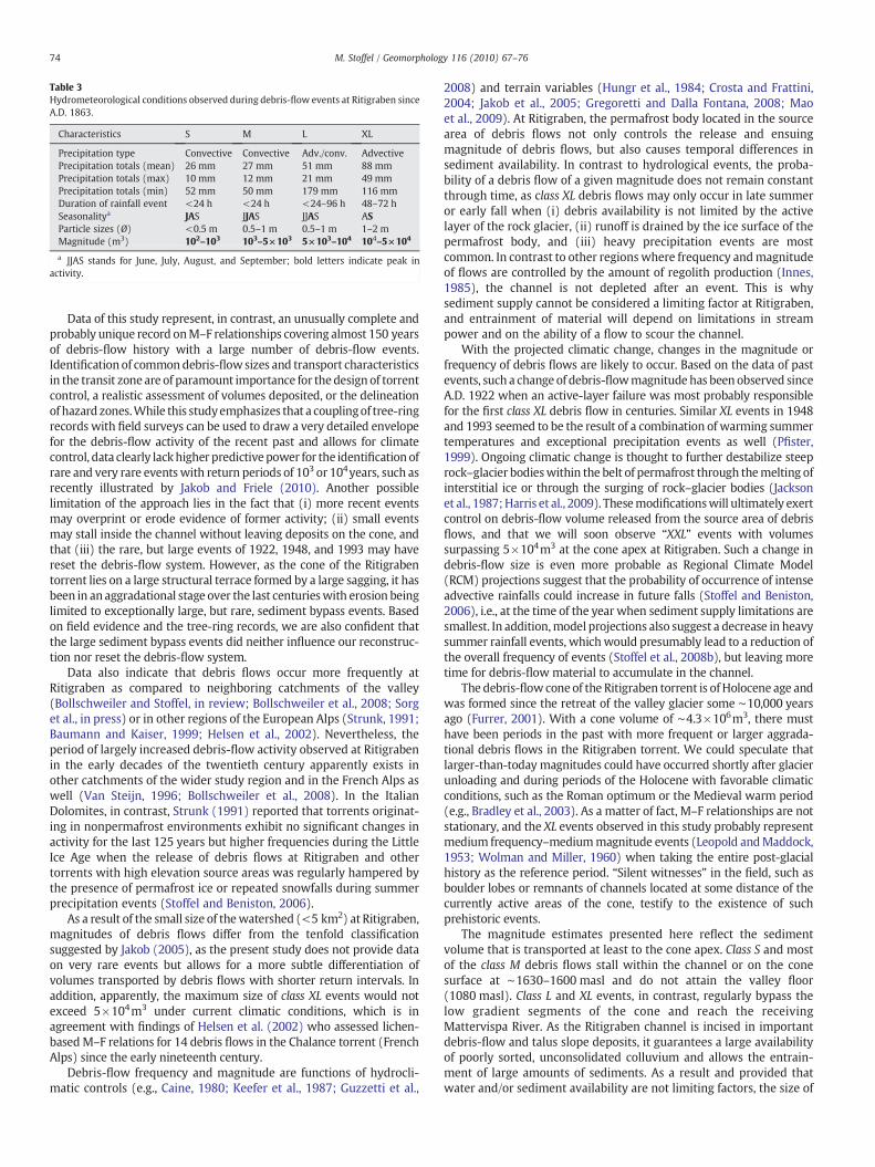
Table 3Hydrometeorological conditions observed during debris-flow events at Ritigraben sinceA.D. 1863.
Characteristics S M L XL
Precipitation type Convective Convective Adv./conv. AdvectivePrecipitation totals (mean) 26 mm 27 mm 51 mm 88 mmPrecipitation totals (max) 10 mm 12 mm 21 mm 49 mmPrecipitation totals (min) 52 mm 50 mm 179 mm 116 mmDuration of rainfall event <24 h <24 h <24–96 h 48–72 hSeasonalitya JAS JJAS JJAS ASParticle sizes (Ø) <0.5 m 0.5–1 m 0.5–1 m 1–2 mMagnitude (m3) 102–103 103–5×10³ 5×10³–104 104–5×10⁴
a JJAS stands for June, July, August, and September; bold letters indicate peak inactivity.
74 M. Stoffel / Geomorphology 116 (2010) 67–76
Data of this study represent, in contrast, an unusually complete andprobably unique record onM–F relationships covering almost 150 yearsof debris-flow history with a large number of debris-flow events.Identificationof commondebris-flowsizes and transport characteristicsin the transit zoneare of paramount importance for thedesign of torrentcontrol, a realistic assessment of volumes deposited, or the delineationof hazard zones.While this studyemphasizes that a couplingof tree-ringrecords with field surveys can be used to draw a very detailed envelopefor the debris-flow activity of the recent past and allows for climatecontrol, data clearly lackhigher predictive power for the identification ofrare and very rare eventswith return periods of 103 or 104years, such asrecently illustrated by Jakob and Friele (2010). Another possiblelimitation of the approach lies in the fact that (i) more recent eventsmay overprint or erode evidence of former activity; (ii) small eventsmay stall inside the channel without leaving deposits on the cone, andthat (iii) the rare, but large events of 1922, 1948, and 1993 may havereset the debris-flow system. However, as the cone of the Ritigrabentorrent lies on a large structural terrace formed by a large sagging, it hasbeen in anaggradational stage over the last centurieswith erosion beinglimited to exceptionally large, but rare, sediment bypass events. Basedon field evidence and the tree-ring records, we are also confident thatthe large sediment bypass events did neither influence our reconstruc-tion nor reset the debris-flow system.
Data also indicate that debris flows occur more frequently atRitigraben as compared to neighboring catchments of the valley(Bollschweiler and Stoffel, in review; Bollschweiler et al., 2008; Sorget al., in press) or in other regions of the European Alps (Strunk, 1991;Baumann and Kaiser, 1999; Helsen et al., 2002). Nevertheless, theperiod of largely increased debris-flow activity observed at Ritigrabenin the early decades of the twentieth century apparently exists inother catchments of the wider study region and in the French Alps aswell (Van Steijn, 1996; Bollschweiler et al., 2008). In the ItalianDolomites, in contrast, Strunk (1991) reported that torrents originat-ing in nonpermafrost environments exhibit no significant changes inactivity for the last 125 years but higher frequencies during the LittleIce Age when the release of debris flows at Ritigraben and othertorrents with high elevation source areas was regularly hampered bythe presence of permafrost ice or repeated snowfalls during summerprecipitation events (Stoffel and Beniston, 2006).
As a result of the small size of thewatershed (<5 km2) at Ritigraben,magnitudes of debris flows differ from the tenfold classificationsuggested by Jakob (2005), as the present study does not provide dataon very rare events but allows for a more subtle differentiation ofvolumes transported by debris flows with shorter return intervals. Inaddition, apparently, the maximum size of class XL events would notexceed 5×10⁴m3 under current climatic conditions, which is inagreement with findings of Helsen et al. (2002) who assessed lichen-basedM–F relations for 14 debris flows in the Chalance torrent (FrenchAlps) since the early nineteenth century.
Debris-flow frequency and magnitude are functions of hydrocli-matic controls (e.g., Caine, 1980; Keefer et al., 1987; Guzzetti et al.,
2008) and terrain variables (Hungr et al., 1984; Crosta and Frattini,2004; Jakob et al., 2005; Gregoretti and Dalla Fontana, 2008; Maoet al., 2009). At Ritigraben, the permafrost body located in the sourcearea of debris flows not only controls the release and ensuingmagnitude of debris flows, but also causes temporal differences insediment availability. In contrast to hydrological events, the proba-bility of a debris flow of a given magnitude does not remain constantthrough time, as class XL debris flows may only occur in late summeror early fall when (i) debris availability is not limited by the activelayer of the rock glacier, (ii) runoff is drained by the ice surface of thepermafrost body, and (iii) heavy precipitation events are mostcommon. In contrast to other regions where frequency andmagnitudeof flows are controlled by the amount of regolith production (Innes,1985), the channel is not depleted after an event. This is whysediment supply cannot be considered a limiting factor at Ritigraben,and entrainment of material will depend on limitations in streampower and on the ability of a flow to scour the channel.
With the projected climatic change, changes in the magnitude orfrequency of debris flows are likely to occur. Based on the data of pastevents, such a change of debris-flowmagnitudehas been observed sinceA.D. 1922 when an active-layer failure was most probably responsiblefor the first class XL debris flow in centuries. Similar XL events in 1948and 1993 seemed to be the result of a combination of warming summertemperatures and exceptional precipitation events as well (Pfister,1999). Ongoing climatic change is thought to further destabilize steeprock–glacier bodieswithin the belt of permafrost through themelting ofinterstitial ice or through the surging of rock–glacier bodies (Jacksonet al., 1987;Harris et al., 2009). Thesemodificationswill ultimately exertcontrol on debris-flow volume released from the source area of debrisflows, and that we will soon observe “XXL” events with volumessurpassing 5×10⁴m3 at the cone apex at Ritigraben. Such a change indebris-flow size is even more probable as Regional Climate Model(RCM) projections suggest that the probability of occurrence of intenseadvective rainfalls could increase in future falls (Stoffel and Beniston,2006), i.e., at the time of the year when sediment supply limitations aresmallest. In addition,model projections also suggest a decrease in heavysummer rainfall events, whichwould presumably lead to a reduction ofthe overall frequency of events (Stoffel et al., 2008b), but leaving moretime for debris-flow material to accumulate in the channel.
The debris-flowcone of the Ritigraben torrent is of Holocene age andwas formed since the retreat of the valley glacier some ∼10,000 yearsago (Furrer, 2001). With a cone volume of ∼4.3×10⁶m3, there musthave been periods in the past with more frequent or larger aggrada-tional debris flows in the Ritigraben torrent. We could speculate thatlarger-than-today magnitudes could have occurred shortly after glacierunloading and during periods of the Holocene with favorable climaticconditions, such as the Roman optimum or the Medieval warm period(e.g., Bradley et al., 2003). As a matter of fact, M–F relationships are notstationary, and the XL events observed in this study probably representmedium frequency–mediummagnitude events (Leopold andMaddock,1953; Wolman and Miller, 1960) when taking the entire post-glacialhistory as the reference period. “Silent witnesses” in the field, such asboulder lobes or remnants of channels located at some distance of thecurrently active areas of the cone, testify to the existence of suchprehistoric events.
The magnitude estimates presented here reflect the sedimentvolume that is transported at least to the cone apex. Class S and mostof the class M debris flows stall within the channel or on the conesurface at ∼1630–1600 masl and do not attain the valley floor(1080 masl). Class L and XL events, in contrast, regularly bypass thelow gradient segments of the cone and reach the receivingMattervispa River. As the Ritigraben channel is incised in importantdebris-flow and talus slope deposits, it guarantees a large availabilityof poorly sorted, unconsolidated colluvium and allows the entrain-ment of large amounts of sediments. As a result and provided thatwater and/or sediment availability are not limiting factors, the size of

75M. Stoffel / Geomorphology 116 (2010) 67–76
individual class L and class XL events may increase in size by up to oneorder of magnitude on the cone and transport almost 105m3 to theconfluence of the Ritigraben torrent with theMattervispa River. Whilethe class S and M events are important in terms of long-term debristransport from the source area of debris flows and aggradation on thecone, clearly the class L and XL events are playing the primordial rolein the transport of sediment into the Mattervispa River system.
7. Conclusions
Dendrochronology has proved to be a very reliable method toestablish a debris-flow frequency and related magnitudes on a localscale in a mountain environment with low precipitation amounts andthe presence of a perennially frozen ground in the source area of debrisflows. Although the quality and quantity of the data set presented isone of the most comprehensive compiled worldwide to date, thenature of the data does not allow for a formal application of extremevalue frequency analysis as commonly used for perennial streams inhydrology. This is because debris flows exhibit an episodic rather thancontinuous behavior and are not usuallymonitored. Nevertheless, thisstudy shows, for the first time, that the nonstationarity of climaticvariables chiefly influences the frequency of debris flows and that themagnitude of events at this high elevation site subsequently under-goes changes with time as well. Also changes in magnitude similar tothose observed since the early twentieth century will continue tooccur in a warmer greenhouse climate, and the size of individualeventsmight attain volumes thatwould not have been possible duringthe past few centuries.
Acknowledgements
Thiswork has been undertaken partly in the context of the followingprojects: EU-FP7 project ACQWA (project no. GOCE-20290), and FOEN-SFP-SRCE project RUFINE (project no. 0931030100RA0000008253).This study considerably benefited from the critical comments of FritzSchlunegger, Michelle Bollschweiler, and two anonymous reviewers aswell as from substantial contributions of Delphine Conus, Michael A.Grichting, Igor Lièvre, and Gilles Maître during fieldwork and sampleanalysis.
References
Baumann, F., Kaiser, K.F., 1999. The Multetta debris fan, eastern Swiss Alps: a 500-yeardebris flow chronology. Arct. Alp. Res. 31, 128–134.
Bezzola, G.R., Hegg, C. (Eds.), 2007. Ereignisanalyse Hochwasser 2005. Teil 1 - Prozesse,Schäden und erste Einordnung. Bundesamt Umwelt BAFU and Eidg. Forsch'anst.WSL, Bern, Birmensdorf, Switzerland. 215 pp. (in German).
Blair, T.C., 1999. Sedimentology of the debris-flow dominated Warm Spring Canyonalluvial fan, Death Valley, California. Sedimentology 46, 941–957.
Blair, T.C., McPherson, J.G., 1998. Recent debris flow processes and resultant form andfacies of the Dolomite alluvial fan, Owens Valley, California. J. Sediment. Res. 68,800–818.
Blikra, L.H., Nemec, W., 1998. Postglacial colluvium in western Norway: depositionalprocesses, facies and paleoclimatic record. Sedimentology 45, 909–959.
Bloetzer, W., Stoffel, M., 1998. Klimawandel als Herausforderung für die Raumplanungder Vispertäler. In: Bloetzer, W., Egli, T., Petrascheck, A., Sauter, J., Stoffel, M. (Eds.),Klimaänderungen und Naturgefahren in der Raumplanung—Methodische Ansätzeund Fallbeispiele, vdf Hochschulverlag AG, Zürich, pp. 127–200 (in German).
Bollschweiler, M., Stoffel, M., in review. Variations in debris-flow occurrence in anAlpine catchment — reconstruction and implications for the future. Global Planet.Change.
Bollschweiler, M., Ehmisch, M., Stoffel, M., Monbaron, M., 2007. Reconstructing spatio-temporal patterns of debris-flow activity with dendrogeomorphological methods.Geomorphology 87, 337–351.
Bollschweiler, M., Stoffel, M., Schneuwly, D.M., 2008. Dynamics in debris-flow activityon a forested cone — a case study using different dendroecological approaches.Catena 72, 67–78.
Bovis, M.J., Jakob, M., 1999. The role of debris supply conditions in predicting debrisflow activity. Earth Surf. Processess Landf. 24, 1039–1054.
Bradley, R.S., Hughes, M.K., Diaz, H.F., 2003. Climate in medieval time. Science 302,404–405.
Bräker, O.U., 2002. Measuring and data processing in tree-ring research — amethodological introduction. Dendrochronologia 20, 203–216.
Bundesamt für Wasser und Geologie (BWG), 2002. Hochwasser 2000 — Les crues 2000.Berichte des Bundesamtes für Wasser und Geologie, Serie Wasser 2, 1–248 (inGerman).
Caine, N., 1980. The rainfall intensity–duration control of shallow landslides and debrisflows. Geogr. Ann. 62A, 23–27.
Carrara, A., Crosta, G., Frattini, P., 2003. Geomorphological and historical data inassessing landslide hazard. Earth Surf. Processes Landf. 28, 1125–1142.
Crosta, G.B., Frattini, P., 2004. Controls on modern alluvial fan processes in the centralAlps, northern Italy. Earth Surf. Processes Landf. 29, 267–293.
de Scally, F.A., Owens, I.F., 2005. Depositional processes and particle characteristics onfans in the Southern Alps, New Zealand. Geomorphology 69, 46–56.
Eaton, L.S., Morgan, B.A., Kochel, R.C., Howard, A.D., 2003. Quaternary deposits andlandscapeevolution in thecentral BlueRidgeof Virginia. Geomorphology56, 139–154.
Furrer, G., 2001. Alpine Vergletscherung vom letzten Hochglazial bis heute. FranzSteiner Verlag. 49 pp. (in German).
Gómez-Villar, A., García-Ruiz, J.M., 2000. Surface sediment characteristics and presentdynamics in alluvial fans of the central Spanish Pyrenees. Geomorphology 34, 127–144.
Grebner, D., Roesch, T., 1998. Flächen-Mengen-Dauer-Beziehungen von Starknieders-chlägen und mögliche Niederschlagsgrenzwerte im Raum der Schweiz, vdfHochschulverlags AG, Zürich, Switzerland. 190 pp. (in German).
Gregoretti, C., Dalla Fontana, G., 2008. The triggering of debris flow due to channel-bedfailure in some alpine headwater basins of the dolomites: analyses of critical runoff.Hydrol. Process. 22, 2248–2263.
Grissino-Mayer, H.D., 2001. FHX2 — software for analyzing temporal and spatialpatterns in fire regimes from tree rings. Tree-Ring Res. 57 (1), 115–124.
Guzzetti, F., Peruccacci, S., Rossi, M., Stark, C.P., 2008. The rainfall intensity–durationcontrol of shallow landslides and debris flows: an update. Landslides 5, 3–17.
Habersack, H., Krapesch, G., 2006. Hochwasser 2005 — Ereignisdokumentation derBundesbauverwaltung, des Forsttechnischen Dienstes für Wildbach- und Law-inenverbauung und des Hydrographischen Dienstes, Bundesministerium für Land-und Forstwirtschaft, Umwelt und Wasserwirtschaft, Wien. 157 pp. (in German).
Haeberli, W., Rickenmann, D., Zimmermann, M., Rösli, U., 1991. Murgänge, Mitt.Bundesamt Wasserwirtsch. 4, 77–88 (in German).
Hansen, M.H., Hahn, J.T., 1992. Determining stocking, forest type, and stand-size classfrom forest inventory data. Northern J. Appl. For. 9, 82–89.
Harris, C., Arenson, L.U., Christiansen, H.H., Etzelmüller, B., Frauenfelder, R., Gruber, S.,Haeberli, W., Hauck, C., Hölzle, M., Humlum, O., Isaksen, K., Kääb, A., Kern-Lütschg,M.A., Lehning, M., Matsuoka, N., Murton, J.B., Nötzli, J., Phillips, M., Ross, N., Seppälä,M., 2009. Permafrost and climate in Europe: monitoring and modelling thermal,geomorphological and geotechnical responses. Earth-Sci. Rev. 92, 117–171.
Helsen, M.M., Koop, P.J.M., van Steijn, H., 2002. Magnitude–frequency relationship fordebris flows on the fan of the Chalance torrent, Valgaudemar (French Alps). EarthSurf. Processess Landf. 27, 1299–1307.
Hungr, O., Morgan, G.C., Kellerhals, R., 1984. Quantitative analysis of debris torrenthazard for design of remedial measures. Can. Geotech. J. 21, 663–677.
Hungr, O., McDougall, S., Bovis, B., 2005. Entrainment of material by debris flows. In:Jakob, M., Hungr, O. (Eds.), Debris Flow Hazard and Related Phenomena. Springer,Heidelberg, Berlin, pp. 135–158.
Hungr, O., McDougall, S., Wise, M., Cullen, M., 2008. Magnitude–frequency relationshipsof debris flows and debris avalanches in relation to slope relief. Geomorphology 96,355–365.
Hupp, C.R., 1983. Geo-botanical evidence of late Quaternary mass wasting in block fieldareas of Virginia. Earth Surf. Processess Landf. 8, 439–450.
Hupp, C.R., 1984. Dendrogeomorphic evidence of debris flow frequency and magnitudeat Mount Shasta, California. Environ. Geol. Water Sci. 6, 121–128.
Innes, J.L., 1983. Lichenometric dating of debris-flow deposits in the Scottish Highlands.Earth Surf. Processess Landf. 8, 579–588.
Innes, J.L., 1985. Magnitude–frequency relations of debris flows in northwest Europe.Geogr. Ann. 67A, 519–524.
Iverson, R.M., 1997. The physics of debris flows. Rev. Geophys. 35, 245–296.Jackson, L.E., Kostaschuck, R.A.,MacDonald, G.M., 1987. Identification of debrisflowhazard
on alluvial fans in the Canadian Rocky Mountains. Rev. Eng. Geol. 7, 115–124.Jakob, M., 1996. Morphometric and geotechnical controls of debris flow frequency and
magnitude in southwestern British Columbia. Ph.D. dissertation, University ofBritish Columbia at Vancouver, Vancouver, BC, Canada, 232 pp.
Jakob, M., 2005. A size classification for debris flows. Eng. Geol. 79, 151–161.Jakob, M., Friele, P., 2010. Frequency and magnitude of debris flows on Cheekye River,
British Columbia. Geomorphology 114 (3), 382–395.Jakob, M., Hungr, O., 2005. Debris Flow Hazard and Related Phenomena. Springer,
Heidelberg, Berlin. 739 pp.Jakob, M., Hungr, O., Anderson, D., Fuller, T., Ayotte, D., 2000. The July 7, 1997 debris
flow at Hummingbird Creek. Can. Geotech. J. 37, 1109–1125.Jakob, M., Bovis, M., Oden, M., 2005. The significance of channel recharge rates for
estimating debris-flow magnitude and frequency. Earth Surf. Processess Landf. 30,755–766.
Johnson, P.A., McCuen, R.H., Hromadga, T.V., 1991. Magnitude and frequency of debrisflows. J. Hydrol. 123, 68–82.
Keefer, D.K., Wilson, R.C., Mark, R.K., Brabb, E.E., Brown, W.M., Ellen, S.D., Harp, E.L.,Wieczorek, G.F., Alger, C.S., Zatkin, R.S., 1987. Real-time landslide warning duringheavy rainfall. Science 238, 921–925.
Leopold, L.B., Maddock Jr., T., 1953. The hydrologic geometry of stream channels andsome physiographic implications. U. S. Geol. Surv. Prof. Pap. 282-B, 39–85.
Lugon, R., Monbaron, M., 1997. Stabilité des terrains meubles en zone de pergélisol etchangements climatiques. Deux études de cas en Valais: Le Ritigraben (Mattertal)et la moraine du Dolent (Val Ferret). Zürich: vdf Hochschulverlag AG, Zürich,Switzerland, 101 pp. (in French).

76 M. Stoffel / Geomorphology 116 (2010) 67–76
Mao, L., Cavalli, M., Comiti, F., Marchi, L., Lenzi, M.A., Arattano, M., 2009. Sedimenttransfer processes in two Alpine catchments of contrasting morphological settings.J. Hydrol. 364, 88–98.
Marchi, L., D'Agostini, V., 2004. Estimation of debris-flow magnitude in the easternItalian Alps. Earth Surf. Processess Landf. 29, 207–220.
McArdell, B.W., Bartelt, P., Kowalski, J., 2007. Field observations of basal forces and fluidpore pressure in a debris flow. Geophys. Res. Lett. 34, L07406.
MeteoSwiss, 2009. Swiss Meteorological Office. www.meteoschweiz.ch (site lastvisisted May 13, 2009).
Noverraz, F., Bonnard, C., Dupraz, H., Huguenin, L., 1998. Grands glissements de terrain etclimat. Versinclim — comportement passé, présent et futur des grands versantsinstables subactifs en fonction de l'évolution climatique, et évolution en continue desmouvements en profondeur, vdf Hochschulverlags AG, Zürich, Switzerland, 265 pp.(in French).
Ohmori, H., Hirano, M., 1988. Magnitude, frequency and geomorphological significanceof rocky mud flows, landcreep and the collapse of steep slopes. Z. Geomorphol. N. F.Suppl.bd 67, 55–65.
Osterkamp, W.R., Hupp, C.R., Blodgett, J.C., 1986. Magnitude and frequency of debrisflows, and areas of hazard on Mount Shasta, Northern California. U. S. Geol. Surv.Prof. Pap. 1396-C, 1–20.
Pfister, C., 1999. Wetternachhersage. Paul Haupt Verlag, Bern, Stuttgart, Wien. 304 pp.(in German).
Pierson, T.C., 1980. Erosion and deposition by debris flows at Mt. Thomas, northCanterbury, New Zealand. Earth Surf. Processes 5, 227–247.
Rapp, A., Nyberg, R., 1981. Alpine debris flows in northern Scandinavia. Geogr. Ann.63A, 183–196.
Rickenmann, D., 1999. Empirical relationships for debris flows. Nat. Hazards 19, 47–77.Rickenmann, D., Zimmermann, M., 1993. The 1987 debris flows in Switzerland:
documentation and analysis. Geomorphology 8, 175–189.Scheidl, C., Rickenmann, D., Chiari, M., 2008. The use of airborne LiDAR data for the
analysis of debris flow events in Switzerland. Nat. Hazards Earth Syst. Sci. 8,1113–1127.
Scott, K.M., 1989. Magnitude and frequency of lahars and lahar runout flows in theToutle–Cowlitz River System. U.S. Geol. Surv. Open-File Rep, pp. 90–385. 106 pp.
Sorg, A., Bugmann, H., Bollschweiler, M., Stoffel, M., in press. Debris-flow activity along atorrent in the Swiss Alps: minimum frequency of events and implications for forestdynamics. Dendrochronologia.
Stoffel, M., Beniston, M., 2006. On the incidence of debris flows from the early Little IceAge to a future greenhouse climate: a case study from the Swiss Alps. Geophys. Res.Lett. 33, L16404.
Stoffel, M., Bollschweiler, M., 2008. Tree-ring analysis in natural hazards research — anoverview. Nat. Hazard Earth Syst. Sci. 8, 187–202.
Stoffel, M., Bollschweiler, M., 2009. What tree rings can tell about earth–surfaceprocesses. Teaching the principles of dendrogeomorphology. Geogr. Compass 3,1013–1037.
Stoffel, M., Lièvre, I., Conus, D., Grichting, M.A., Raetzo, H., Gärtner, H.W., Monbaron, M.,2005. 400 years of debris flow activity and triggering weather conditions:Ritigraben, Valais, Switzerland. Arct. Antarc. Alp. Res. 37, 387–395.
Stoffel, M., Bollschweiler, M., Hassler, G.R., 2006. Differentiating events on a coneinfluenced by debris-flow and snow avalanche activity — a dendrogeomorpholo-gical approach. Earth Surf. Processess Landf. 31, 1424–1437.
Stoffel, M., Bollschweiler, M., Leutwiler, A., Aeby, P., 2008a. Large debris-flow events andoverbank sedimentation in the Illgraben torrent (Valais Alps, Switzerland). OpenGeol. J. 2, 18–29.
Stoffel, M., Conus, D., Grichting, M.A., Lièvre, I., Maître, G., 2008b. Unraveling thepatterns of late Holocene deposition processes and channel incision on a debris-flow cone in the Swiss Alps: chronology, environment and implications for thefuture. Global Planet. Change 60, 222–234.
Stoffel, M., Bollschweiler, M., Beniston, M., in review. Rainfall characteristics forperiglacial debris flows in the Swiss Alps: past incidences — potential futureevolutions. Clim. Change.
Strunk, H., 1991. Frequency distribution of debris flows in the Alps since the ‘Little IceAge’. Z. Geomorph. Suppl. Bd. 83, 71–81.
Strunk, H., 1997. Dating of geomorphological processes using dendrogeomorphologicalmethods. Catena 31, 137–151.
Van Steijn, H., 1996. Debris-flow magnitude–frequency relationships for mountainousregions of central and northwest Europe. Geomorphology 15, 259–273.
VanDine, D.F., 1985. Debris flows and debris torrents in the southern CanadianCordillera. Can. Geotech. J. 22, 44–67.
Wolman, M.G., Miller, W.P., 1960. Magnitude and frequency of forces in geomorphicprocesses. J. Geol. 68, 54–74.
Zimmermann, M., Mani, P., Romang, H., 1997. Magnitude–frequency aspects of alpinedebris flows. Eclogae Geol. Helv. 90, 415–420.